
A Novel Algorithm for Estimating the Sand Dune Density of the Taklimakan Desert Based on Remote Sensing Data

 , , , and
Abstract
1. Introduction
2. Materials and Methods
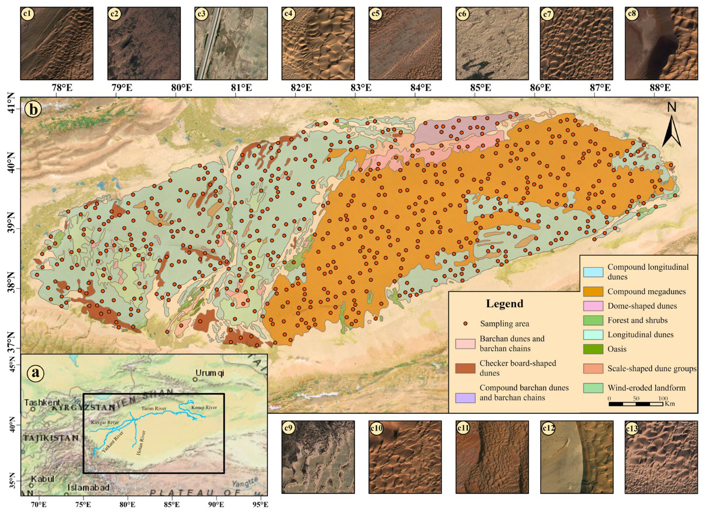
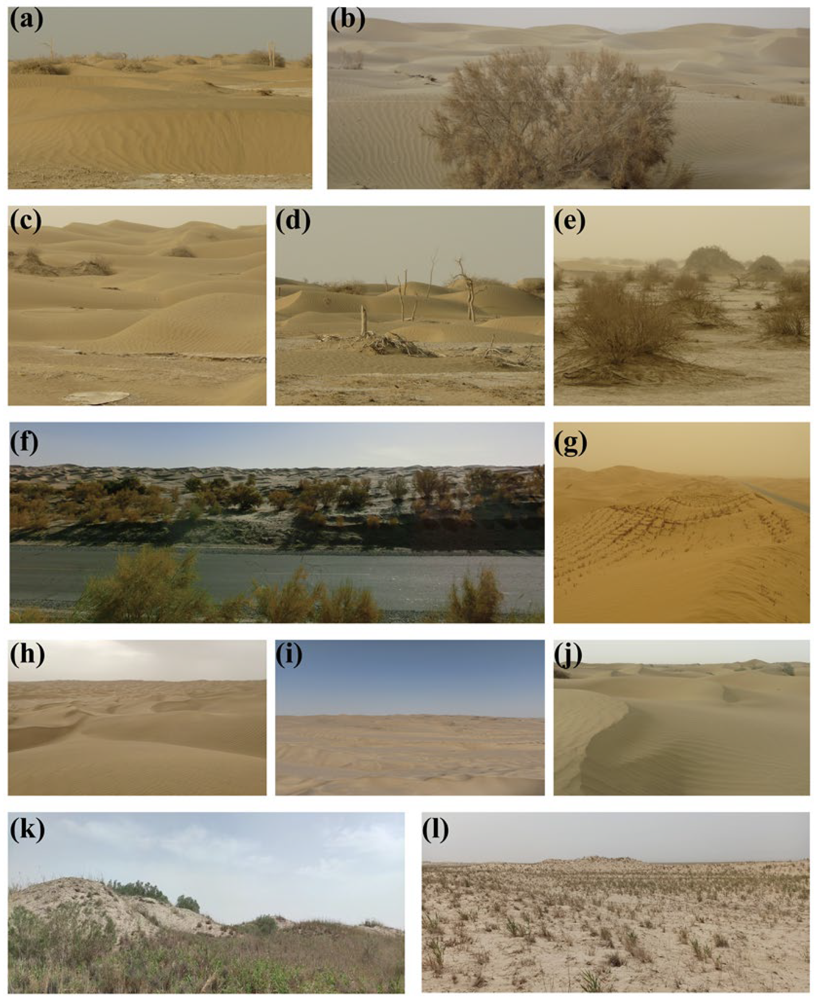
2.1. Study Area
2.2. Data and Pre-Processing
3. Research Method
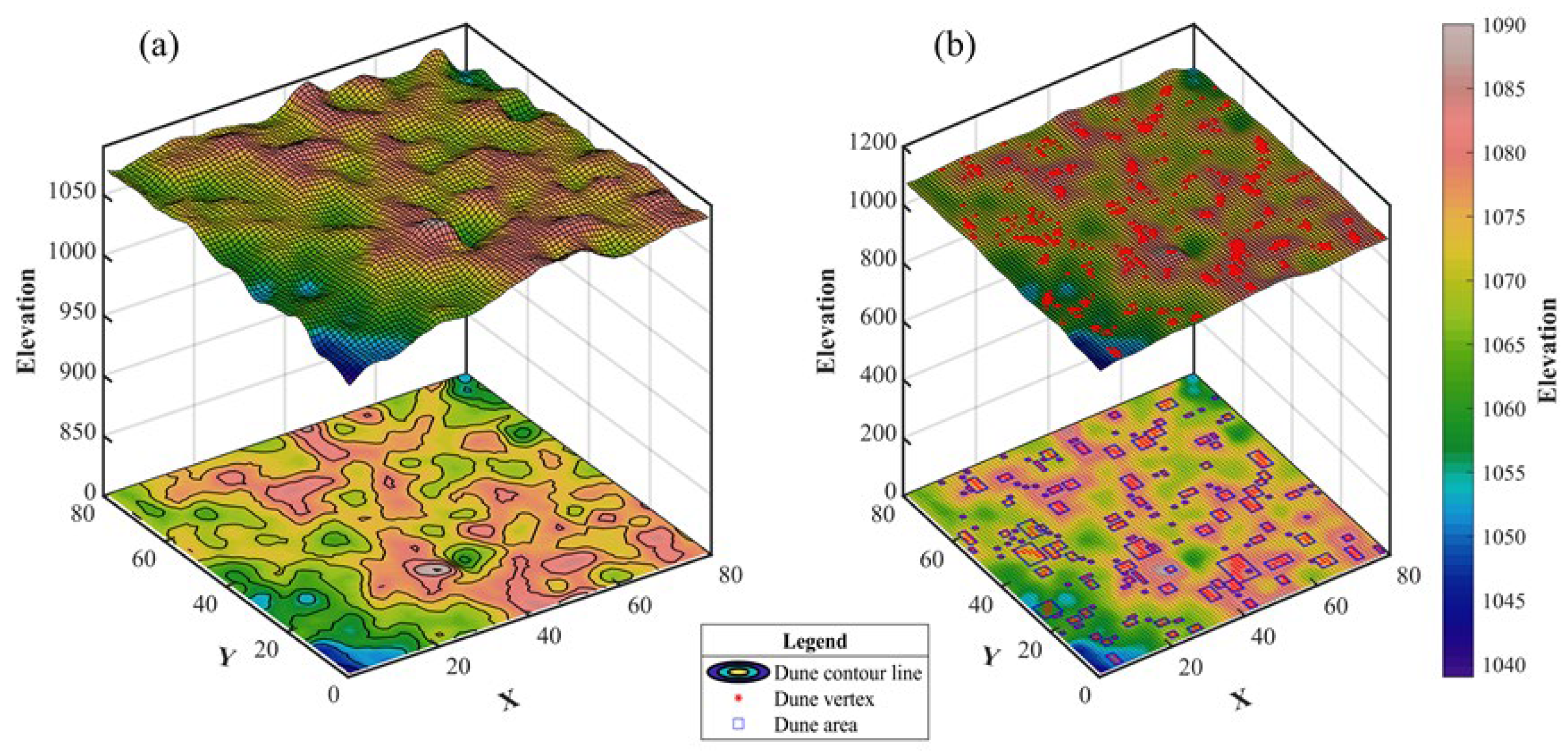
3.1. Dune Density Estimation Model Based on DEM
3.1.1. Extraction Algorithm Based on Dune Vertices
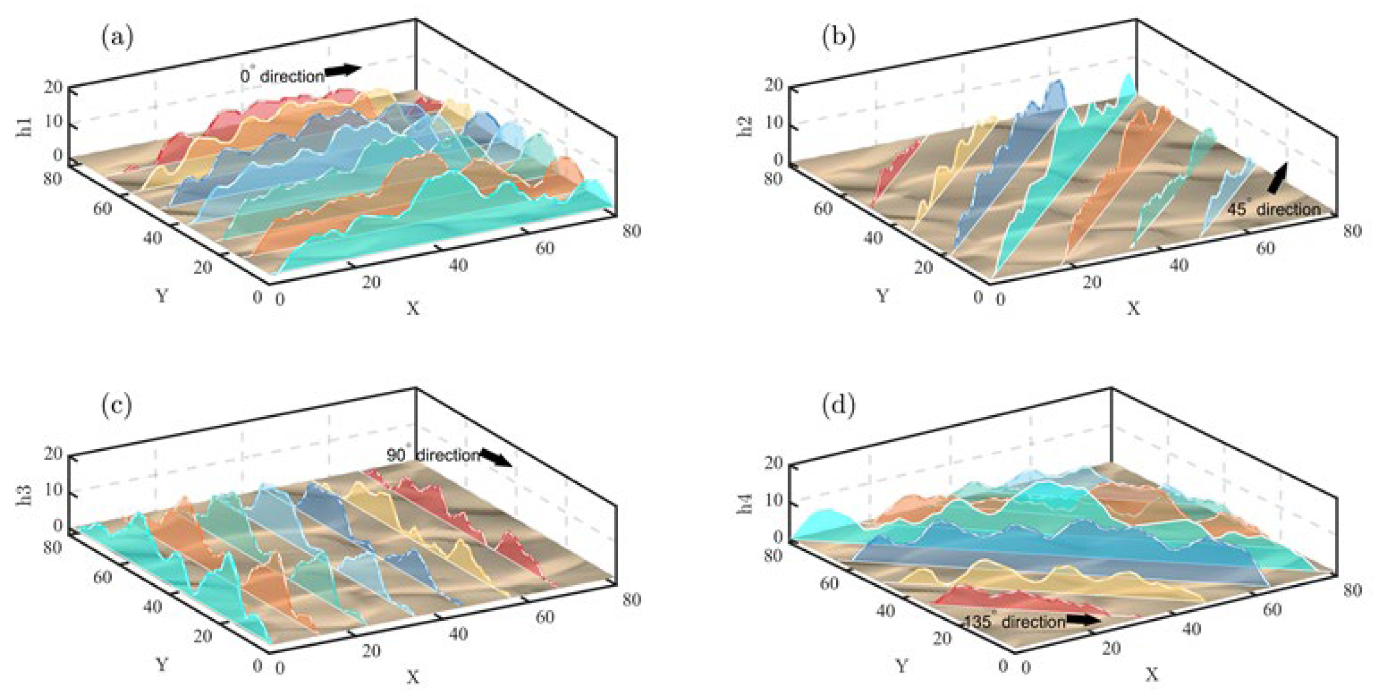
3.1.2. The Orographic Spectral Decomposition of Four-Directional Method
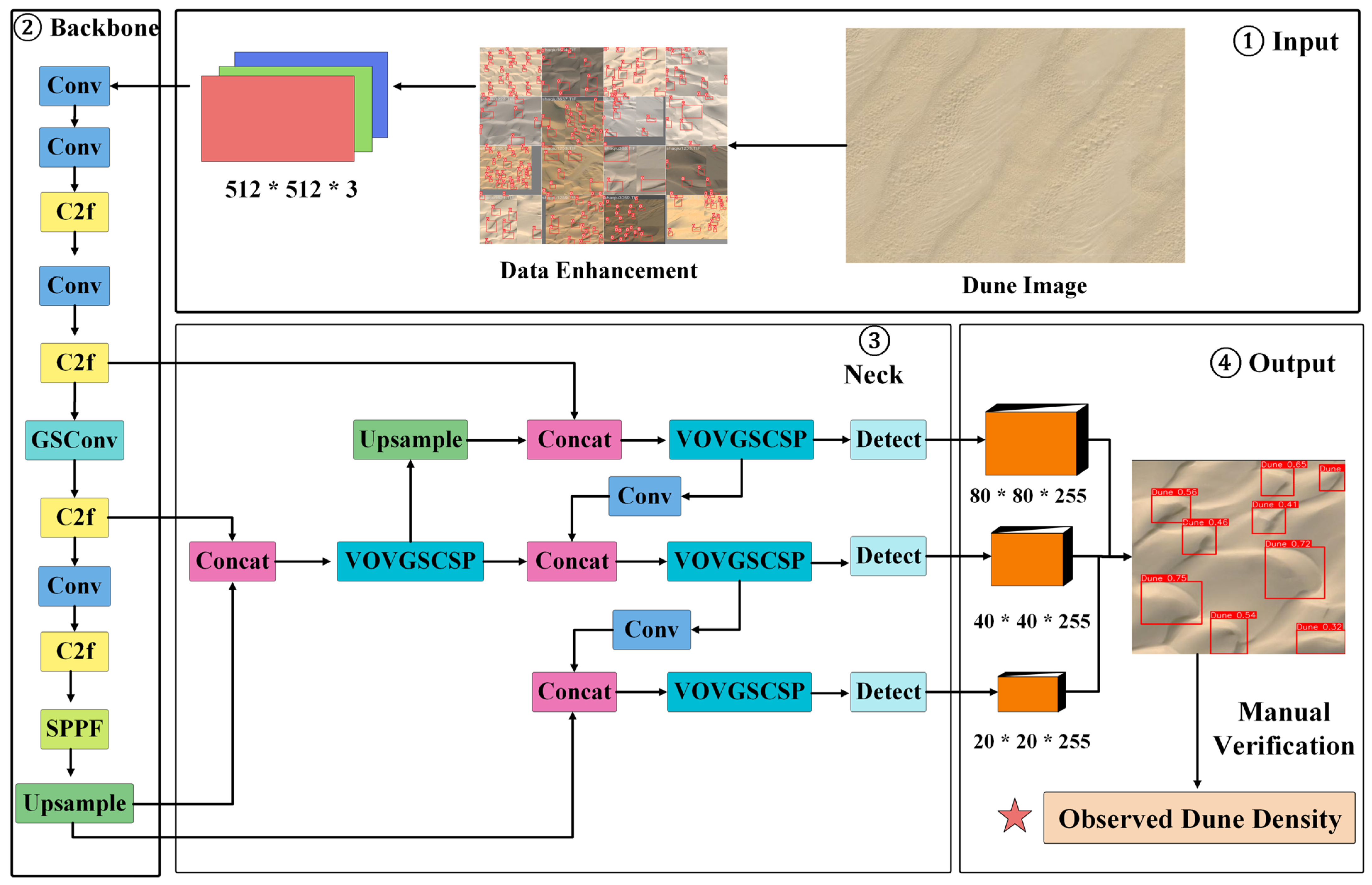
3.2. The Acquisition of Dune Density Observation Data
3.3. Assessment of Factors Influencing Dune Density
4. Results
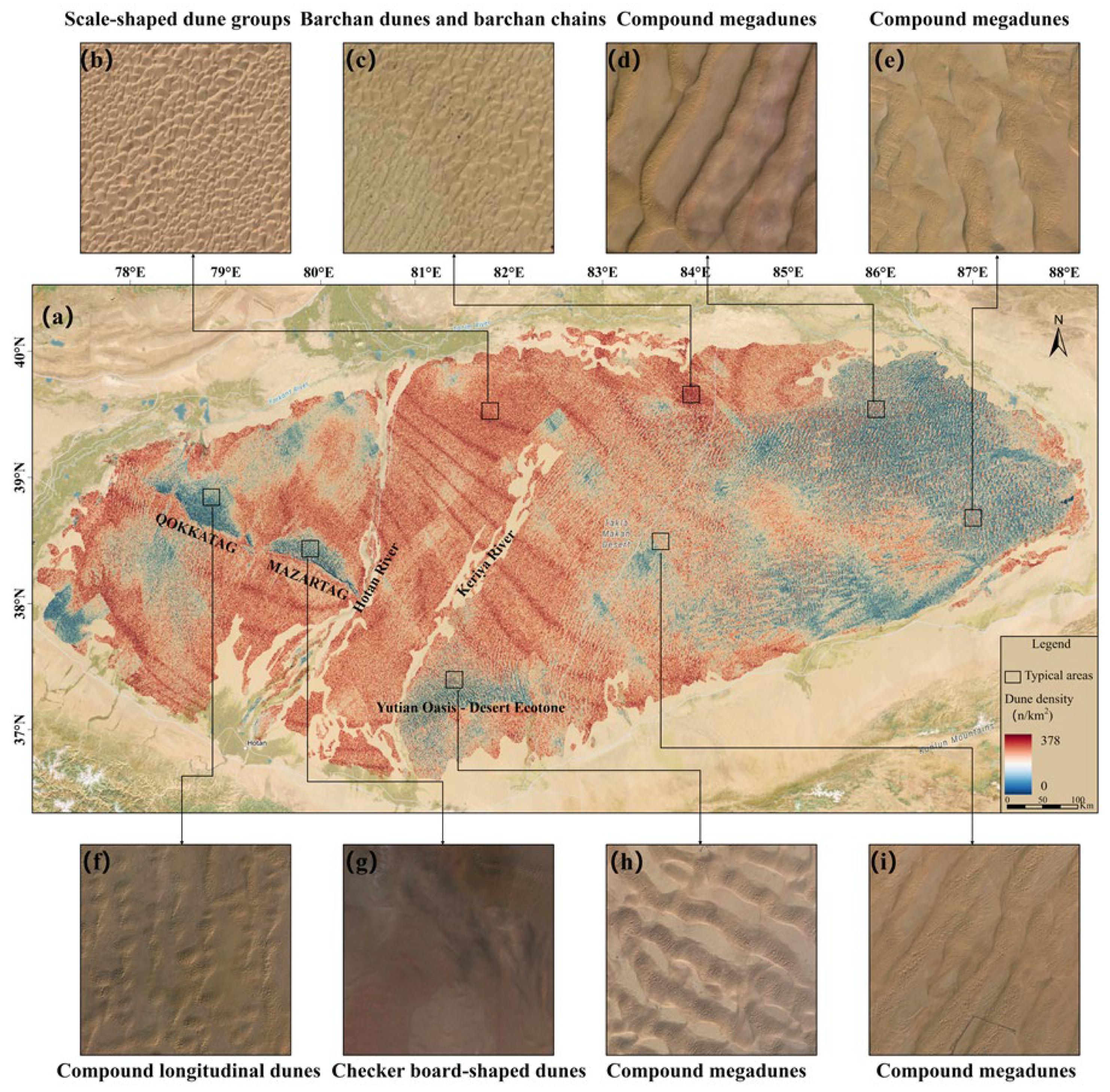
4.1. Dunes Density Distribution Characteristics of TD
4.2. The Assessment of Accuracy in Estimating Dune Density
5. Discussion
5.1. Error Analysis of Dune Density Estimation
5.2. Factors Influencing Spatial Distribution of Dune Density
5.3. Limitations and Future Prospects
6. Conclusions
- (1)
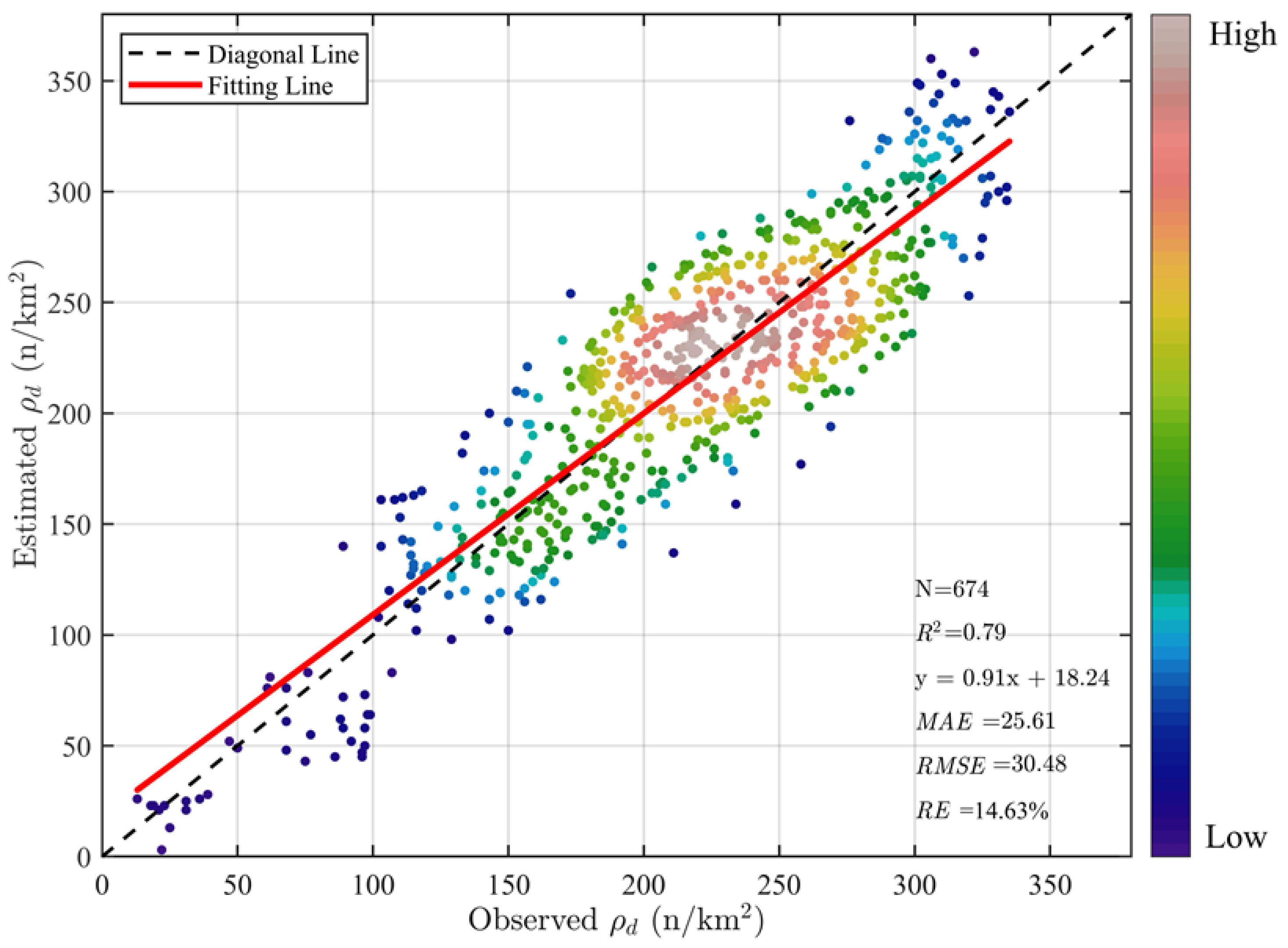
- The new approach has projected that there are approximately 5.31 × 10⁷ dunes in TD. The linear regression fit R2 between the estimated and actual dune density is 0.79. The MAE and RMSE for the sample areas are 25.61 n/km2 and 30.48 n/km2, respectively.
- (2)
- The dune density within the TD exhibits a sparse in the eastern, northeastern, southern (Yutian oasis–desert ecotone), and western (Mazartag Mountain area) parts, while the dune density is higher in the central and northern parts of TD.
- (3)
- The observation data constructed using the enhanced YOLOv8s algorithm and remote sensing imagery can effectively validate the estimation results of dune density.
Supplementary Materials
Author Contributions
Funding
Data Availability Statement
Acknowledgments
Conflicts of Interest
References
- Peng, L.; Wan, Y.; Shi, H.; Anwaier, A.; Shi, Q. Influence of Climate, Topography, and Hydrology on Vegetation Distribution Patterns—Oasis in the Taklamakan Desert Hinterland. Remote Sens. 2023, 15, 5299. [Google Scholar] [CrossRef]
- Jin, L.; He, Q.; Li, Z.; Deng, M.; Abbas, A. Variation characteristics of dust in the Taklimakan Desert. Nat. Hazards 2024, 120, 2129–2153. [Google Scholar] [CrossRef]
- Li, H.; Wang, C. Impact of dust radiation effect on simulations of temperature and wind—A case study in Taklimakan Desert. Atmos. Res. 2022, 273, 106163. [Google Scholar] [CrossRef]
- Aili, A.; Kim Oanh, N.T. Effects of dust storm on public health in desert fringe area: Case study of northeast edge of Taklimakan Desert, China. Atmos. Pollut. Res. 2015, 6, 805–814. [Google Scholar] [CrossRef]
- Yang, Z.; Gao, X.; Lei, J. Fuzzy comprehensive risk evaluation of Aeolian disasters in Xinjiang, Northwest China. Aeolian Res. 2021, 48, 100647. [Google Scholar] [CrossRef]
- Tang, C.; Lin, Y.; Tian, P.; Shi, J.; Deng, T.; Deng, X.; Zou, Y.; Zhang, L. Enhanced mass scattering efficiencies of background dust aerosols over East Asia following the passage of dust plumes. Atmos. Environ. 2024, 338, 120862. [Google Scholar] [CrossRef]
- Wang, X.; Zhang, C. Field observations of sand flux and dust emission above a gobi desert surface. J. Soils Sediments 2021, 21, 1815–1825. [Google Scholar] [CrossRef]
- Wang, J.; Wang, T.; Yasheng, D.; Wang, X.; Lei, Y.; Li, X.; Wang, Z.; Shi, B. Modulations of dust aerosols on precipitation: Evidence from a typical heavy sandstorm event. Atmos. Res. 2024, 304, 107411. [Google Scholar] [CrossRef]
- Xue, H.; Shen, X. A turbulent orographic form drag scheme accounting for anisotropy and orientation for kilometer- to subkilometer-scale models. Q. J. R. Meteorol. Soc. 2023, 149, 2527–2549. [Google Scholar] [CrossRef]
- Feng, X.; Xu, X.; Yao, X.; Zhao, Y.; Tang, Y.; Zhao, Z.; Wei, Y.; Mehmood, T.; Luo, X. Sources, compositions, spatio-temporal distributions, and human health risks of bioaerosols: A review. Atmos. Res. 2024, 305, 107453. [Google Scholar] [CrossRef]
- Jin, L.L.; Li, Z.J.; He, Q.; Miao, Q.L.; Zhang, H.Q.; Yang, X.H. Observation and Simulation of Near-Surface Wind and Its Variation with Topography in Urumqi, West China. J. Meteorol. Res. 2016, 30, 961–982. [Google Scholar] [CrossRef]
- He, Q.; Li, J.; Zhao, T.; Zhang, H.; Meng, L. Observing a dust aerosol layer at a height of 3-4 km above the ground on the southern margin of the Tarim Basin. Atmos. Environ. 2024, 318, 120236. [Google Scholar] [CrossRef]
- Jackson, D.W.T.; Cooper, A.; Green, A.; Beyers, M.; Guisado-Pintado, E.; Wiles, E.; Benallack, K.; Balme, M. Reversing transverse dunes: Modelling of airflow switching using 3D computational fluid dynamics. Earth Planet. Sci. Lett. 2020, 544, 116363. [Google Scholar] [CrossRef]
- Beljaars, A.; Brown, A.R.; Wood, N. A new parametrization of turbulent orographic form drag. Q. J. R. Meteorol. Soc. 2004, 130, 1327–1347. [Google Scholar] [CrossRef]
- Wang, X.; Dong, Z.; Zhang, J.; Chen, G. Geomorphology of sand dunes in the Northeast Taklimakan Desert. Geomorphology 2002, 42, 183–195. [Google Scholar] [CrossRef]
- Dong, Z.; Wang, X.; Chen, G. Monitoring sand dune advance in the Taklimakan Desert. Geomorphology 2000, 35, 219–231. [Google Scholar] [CrossRef]
- Tsuchiya, K.; Oguro, Y. Observation of large fixed sand dunes of Taklimakan Desert using satellite imagery. Adv. Space Res. 2007, 39, 60–64. [Google Scholar] [CrossRef]
- Dong, Z.; Wei, Z.; Qian, G.; Zhang, Z.; Luo, W.; Hu, G. “Raked” linear dunes in the Kumtagh Desert, China. Geomorphology 2010, 123, 122–128. [Google Scholar] [CrossRef]
- Telbisz, T.; Keszler, O. DEM-based morphometry of large-scale sand dune patterns in the Grand Erg Oriental (Northern Sahara Desert, Africa). Arab. J. Geosci. 2018, 11, 382. [Google Scholar] [CrossRef]
- Niu, Z.; Wang, N.; Meng, N.; Liu, J.; Liang, X.; Cheng, H.; Wen, P.; Yu, X.; Zhang, W.; Liang, X. Contribution of Lake-Dune Patterning to the Dune Height of Mega-Dunes in the Badain Jaran Sand Sea, Northern China. Remote Sens. 2021, 13, 4915. [Google Scholar] [CrossRef]
- Xiao, X.; Liu, H.; Zheng, X. Temporal Evolution of Dune Number Density in a Barchan Dune Field. J. Geophys. Res. Earth Surf. 2023, 128, e2022JF007036. [Google Scholar] [CrossRef]
- Zheng, Z.; Du, S.; Taubenboeck, H.; Zhang, X. Remote sensing techniques in the investigation of aeolian sand dunes: A review of recent advances. Remote Sens. Environ. 2022, 271, 112913. [Google Scholar] [CrossRef]
- Yang, X.P. Landscape evolution and palaeoclimate in the deserts of northwestern China, with a special reference to Badain Jaran and Taklamakan. Chin. Sci. Bull. 2001, 46, 6–11. [Google Scholar] [CrossRef]
- Yiming, F.; Lu, W.; Yao, B.; Xi, L.; Cao, X.; Liu, Y.; Ning, H. Management regionalization and zoning management tasks of battle against desertification in the core area of Hexi Corridor-Taklimakan Desert edge. J. Desert Res. 2024, 44, 91–101. (In Chinese) [Google Scholar]
- Wang, K.; Hui, Z.; Sheng, Y.; Zhang, S.; Xingfan, W.; Hongyu, Y.; Qian, C. Distribution and morphological parameters of dunes in the Badain Jaran Desert based on DEM. J. Desert Res. 2020, 40, 81–94. [Google Scholar]
- Yi, H.; Liu, B.; Zhao, B.; Liu, E. Small Object Detection Algorithm Based on Improved YOLOv8 for Remote Sensing. IEEE J. Sel. Top. Appl. Earth Obs. Remote Sens. 2024, 17, 1734–1747. [Google Scholar] [CrossRef]
- Li, H.; Li, J.; Wei, H.; Liu, Z.; Zhan, Z.; Ren, Q. Slim-neck by GSConv: A better design paradigm of detector architectures for autonomous vehicles. arXiv 2022, arXiv:2206.02424. [Google Scholar]
- Zhang, Z.; Dong, X.; Tian, J.; Tian, Q.; Xi, Y.; He, D. Stand density estimation based on fractional vegetation coverage from Sentinel-2 satellite imagery. Int. J. Appl. Earth Obs. Geoinf. 2022, 108, 102760. [Google Scholar] [CrossRef]
- Zu, R.; Xue, X.; Qiang, M.; Yang, B.; Qu, J.; Zhang, K. Characteristics of near-surface wind regimes in the Taklimakan Desert, China. Geomorphology 2008, 96, 39–47. [Google Scholar] [CrossRef]
- McKee, E.D. A Study of Global Sand Seas; US Government Printing Office: Washington, DC, USA, 1979. [Google Scholar]
- Zhu, Z.; Wu, Z.; Li, J.; Chen, Z.; Wu, G.; Li, B. Research on Wind and Sand Landforms in the Taklamakan Desert. Sci. Bull. 1966, 17, 620–624. [Google Scholar]
- Wu, L. The 1:1.5 Million Map of Aeolian Landform in Taklimakan Desert (1978); National Cryosphere Desert Data Center: Lanzhou, China, 2020. [Google Scholar]
- Song, Q.; Gao, X.; Du, H.; Lei, J.; Li, S.; Li, S. Cultivation impacts on soil texture during oasis expansion in Xinjiang, Northwest China: Wind erosion effects. Aeolian Res. 2021, 50, 100646. [Google Scholar] [CrossRef]
- Liu, B.; Sun, A.; Zhao, H.; Fan, Y.; Yang, L.; Li, Y.; Li, S.; Wang, K. Physicochemical properties of surface sediments in the Taklimakan desert, northwestern China, and their relationship with oasis-desert evolution. Catena 2022, 208, 105751. [Google Scholar] [CrossRef]
- Du Pont, S.C.; Narteau, C.; Gao, X. Two modes for dune orientation. Geology 2014, 42, 743–746. [Google Scholar] [CrossRef]
- Askhat, N.; Zhu, K.; Bekzat, R.; Tursunay, V.; Nurzikhan, S.; Daniyar, D.; Yersultan, S.; Kurmanbek, Z.; Issakov, Y.; Antal, S.; et al. Exploring the complexities of sand dune transformation: The role of anthropogenic degradation and climatic conditions. Front. Earth Sci. 2023, 11, 1271127. [Google Scholar] [CrossRef]
- Zhao, H.; Li, B.; Wang, X.F.; Cohen, T.J.; Fan, Y.X.; Yang, H.Y.; Wang, K.Q.; Sheng, Y.W.; Zhan, S.A.; Li, S.H.; et al. Evolution and migration of the highest megadunes on Earth. Glob. Planet. Change 2023, 225, 104133. [Google Scholar] [CrossRef]
- Zhang, Z.; Dong, Z. Field observations of dust transport rates in Gobi deserts. Nat. Hazards 2023, 116, 1689–1709. [Google Scholar] [CrossRef]
- Song, Y.; Chen, X.; Li, Y.; Fan, Y.; Collins, A.L. Quantifying the provenance of dune sediments in the Taklimakan Desert using machine learning, multidimensional scaling and sediment source fingerprinting. Catena 2022, 210, 105902. [Google Scholar] [CrossRef]
- Chen, X.; Song, Y.; Li, Y.; Huang, Y.; Zhou, X.; Fan, Y. Provenance of sub-aerial surface sediments in the Tarim Basin, Western China. Catena 2021, 198, 105014. [Google Scholar] [CrossRef]
- Dong, Z.B.; Wang, X.M.; Zhang, J.W.; Qu, J.J.; Zhao, A.U. Grain size characteristics of dune sands in the central Taklimakan Sand Sea. Sediment. Geol. 2003, 161, 1–14. [Google Scholar]
- Han, Z.W.; Dong, Z.B.; Wang, T.; Chen, G.T.; Yan, C.Z.; Yao, Z.Y. Observations of several characteristics of aeolian sand movement in the Taklimakan Desert. Sci. China Ser. D-Earth Sci. 2004, 47, 86–96. [Google Scholar] [CrossRef]
- Du Pont, S.C.; Rubin, D.M.; Narteau, C.; Lapotre, M.G.A.; Day, M.; Claudin, P.; Livingstone, I.; Telfer, M.W.; Radebaugh, J.; Gadal, C.; et al. Complementary classifications of aeolian dunes based on morphology, dynamics, and fluid mechanics. Earth-Sci. Rev. 2024, 255, 104772. [Google Scholar] [CrossRef]
- Saqqa, W.; Atallah, M. Characterization of the aeolian terrain facies in Wadi Araba Desert, southwestern Jordan. Geomorphology 2004, 62, 63–87. [Google Scholar] [CrossRef]
- Yang, X.; Li, H.; Conacher, A. Large-scale controls on the development of sand seas in northern China. Quat. Int. 2012, 250, 74–83. [Google Scholar] [CrossRef]
- Sun, W.; Gao, X. Geomorphology of sand dunes in the Taklamakan Desert based on ERA5 reanalysis data. J. Arid Environ. 2022, 207, 104848. [Google Scholar] [CrossRef]
- Jiang, N.; Cheng, H. Probability density distributions of morphological parameters of barchan dunes and their responses to the climate environment. Geomorphology 2024, 454, 109164. [Google Scholar] [CrossRef]
- Ma, F.; Lue, P.; Cao, M.; Yu, J.; Xia, Z. Morphological and sedimentary characteristics of raked linear dunes in the southeastern Taklimakan Desert, China. Aeolian Res. 2024, 67, 100923. [Google Scholar] [CrossRef]
- Hu, Z.; Gao, X.; Lei, J.; Zhou, N. Geomorphology of aeolian dunes in the western Sahara Desert. Geomorphology 2021, 392, 107916. [Google Scholar] [CrossRef]
- Zhou, A.; Chen, Y.; Wilson, J.P.; Chen, G.; Min, W.; Xu, R. A multi-terrain feature-based deep convolutional neural network for constructing super-resolution DEMs. Int. J. Appl. Earth Obs. Geoinf. 2023, 120, 103338. [Google Scholar] [CrossRef]
- Yang, F.; Huang, J.; He, Q.; Zheng, X.; Zhou, C.; Pan, H.; Huo, W.; Yu, H.; Liu, X.; Meng, L.; et al. Impact of differences in soil temperature on the desert carbon sink. Geoderma 2020, 379, 114636. [Google Scholar] [CrossRef]


Disclaimer/Publisher’s Note: The statements, opinions and data contained in all publications are solely those of the individual author(s) and contributor(s) and not of MDPI and/or the editor(s). MDPI and/or the editor(s) disclaim responsibility for any injury to people or property resulting from any ideas, methods, instructions or products referred to in the content. |
© 2025 by the authors. Licensee MDPI, Basel, Switzerland. This article is an open access article distributed under the terms and conditions of the Creative Commons Attribution (CC BY) license (https://creativecommons.org/licenses/by/4.0/).
Share and Cite
Wang, M.; Liu, Y.; Li, H.; Wang, M.; Huo, W.; Liu, Z. A Novel Algorithm for Estimating the Sand Dune Density of the Taklimakan Desert Based on Remote Sensing Data. Remote Sens. 2025, 17, 297. https://doi.org/10.3390/rs17020297
Wang M, Liu Y, Li H, Wang M, Huo W, Liu Z. A Novel Algorithm for Estimating the Sand Dune Density of the Taklimakan Desert Based on Remote Sensing Data. Remote Sensing. 2025; 17(2):297. https://doi.org/10.3390/rs17020297
Chicago/Turabian StyleWang, Mingyu, Yongqiang Liu, Huoqing Li, Minzhong Wang, Wen Huo, and Zonghui Liu. 2025. "A Novel Algorithm for Estimating the Sand Dune Density of the Taklimakan Desert Based on Remote Sensing Data" Remote Sensing 17, no. 2: 297. https://doi.org/10.3390/rs17020297
APA StyleWang, M., Liu, Y., Li, H., Wang, M., Huo, W., & Liu, Z. (2025). A Novel Algorithm for Estimating the Sand Dune Density of the Taklimakan Desert Based on Remote Sensing Data. Remote Sensing, 17(2), 297. https://doi.org/10.3390/rs17020297