Unequal Horizons: Global North–South Disparities in Archaeological Earth Observation (2000–2025)
Abstract
Highlights
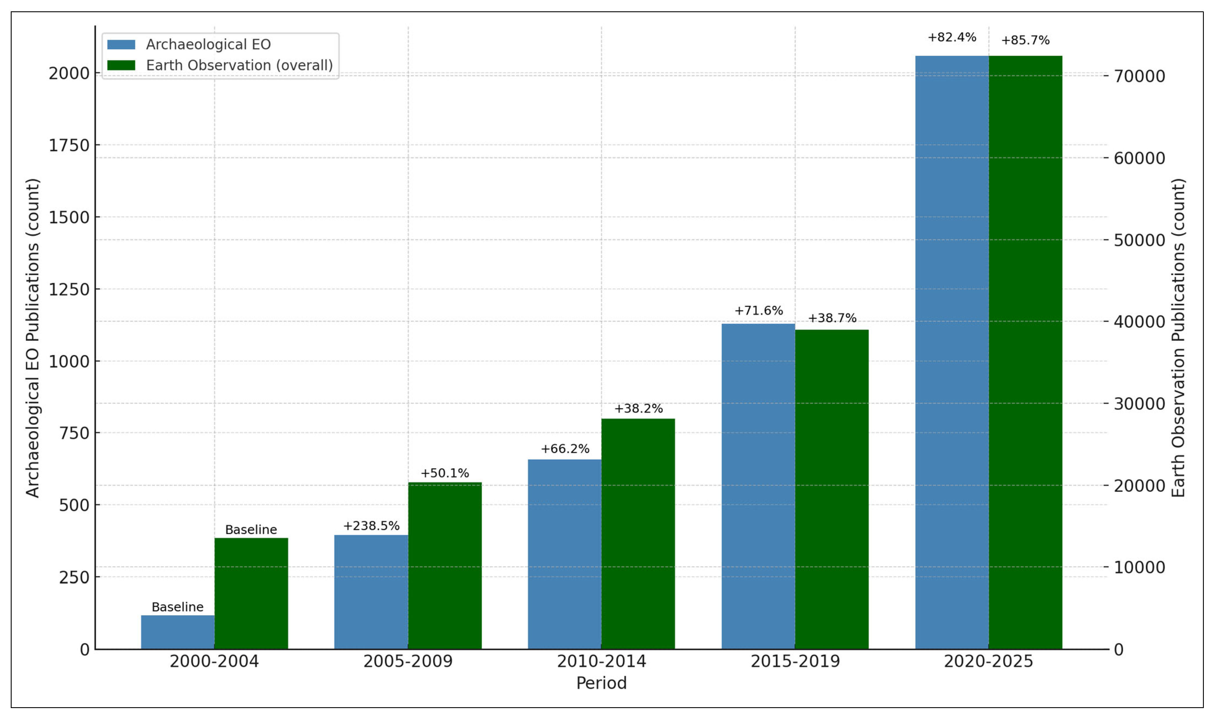
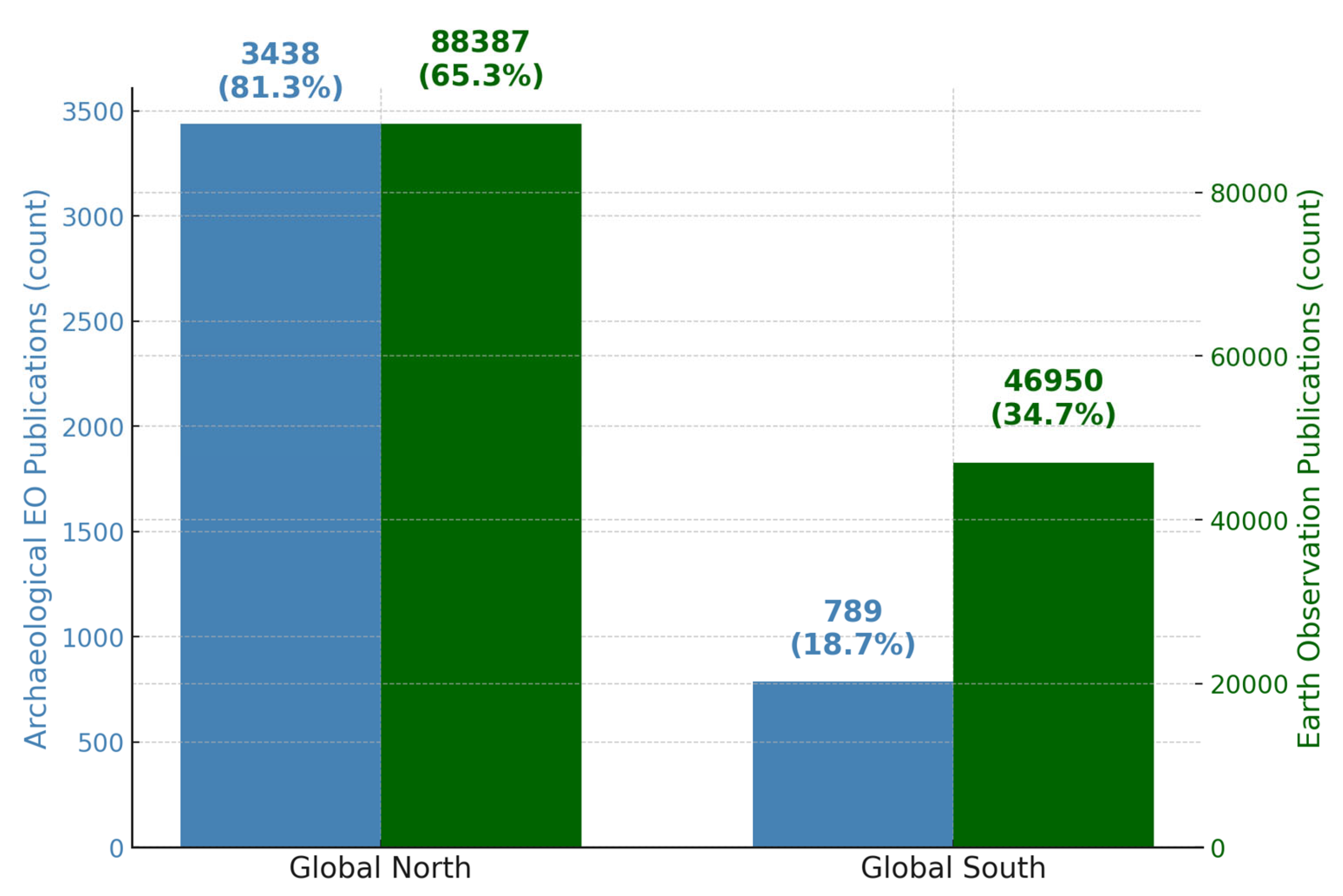
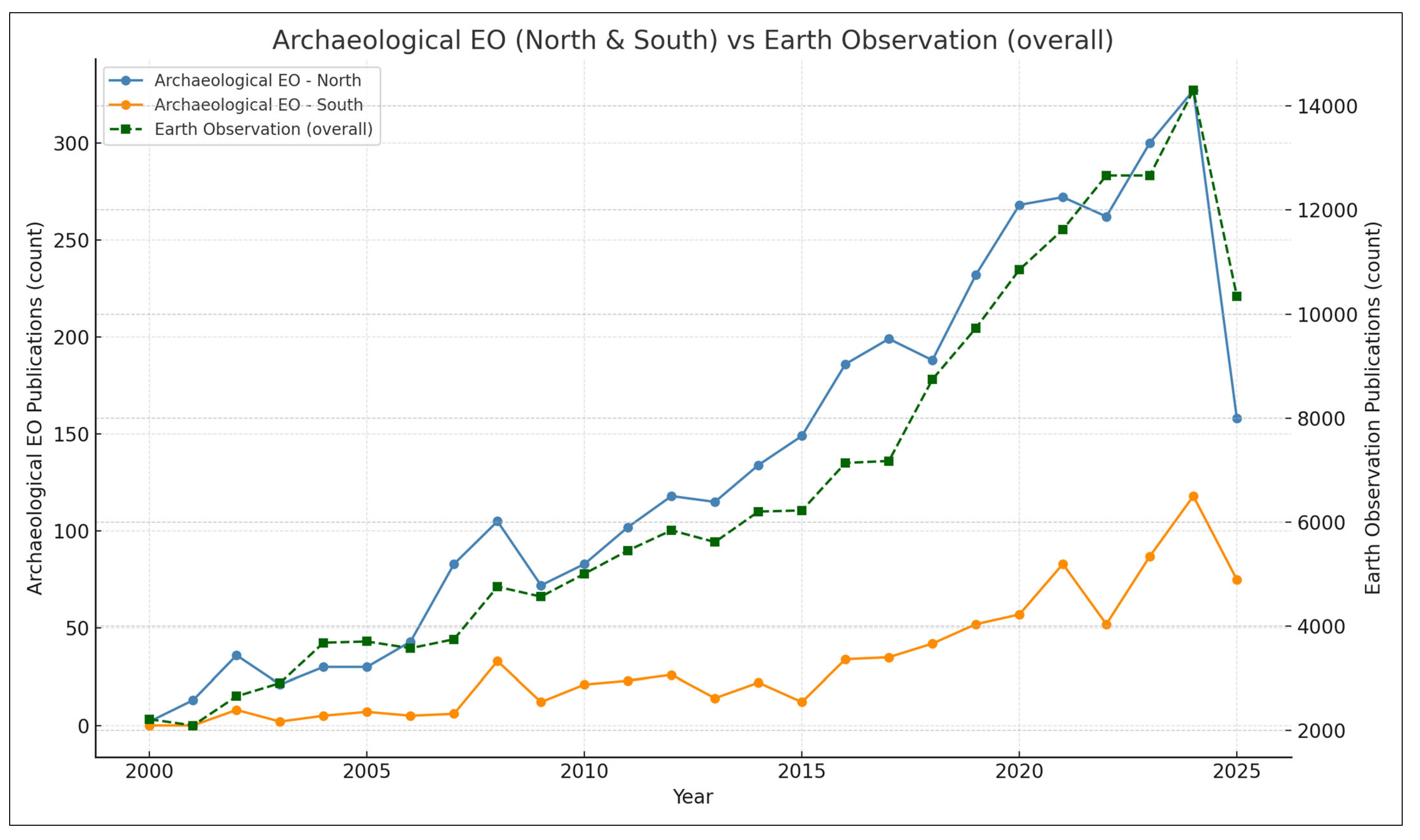
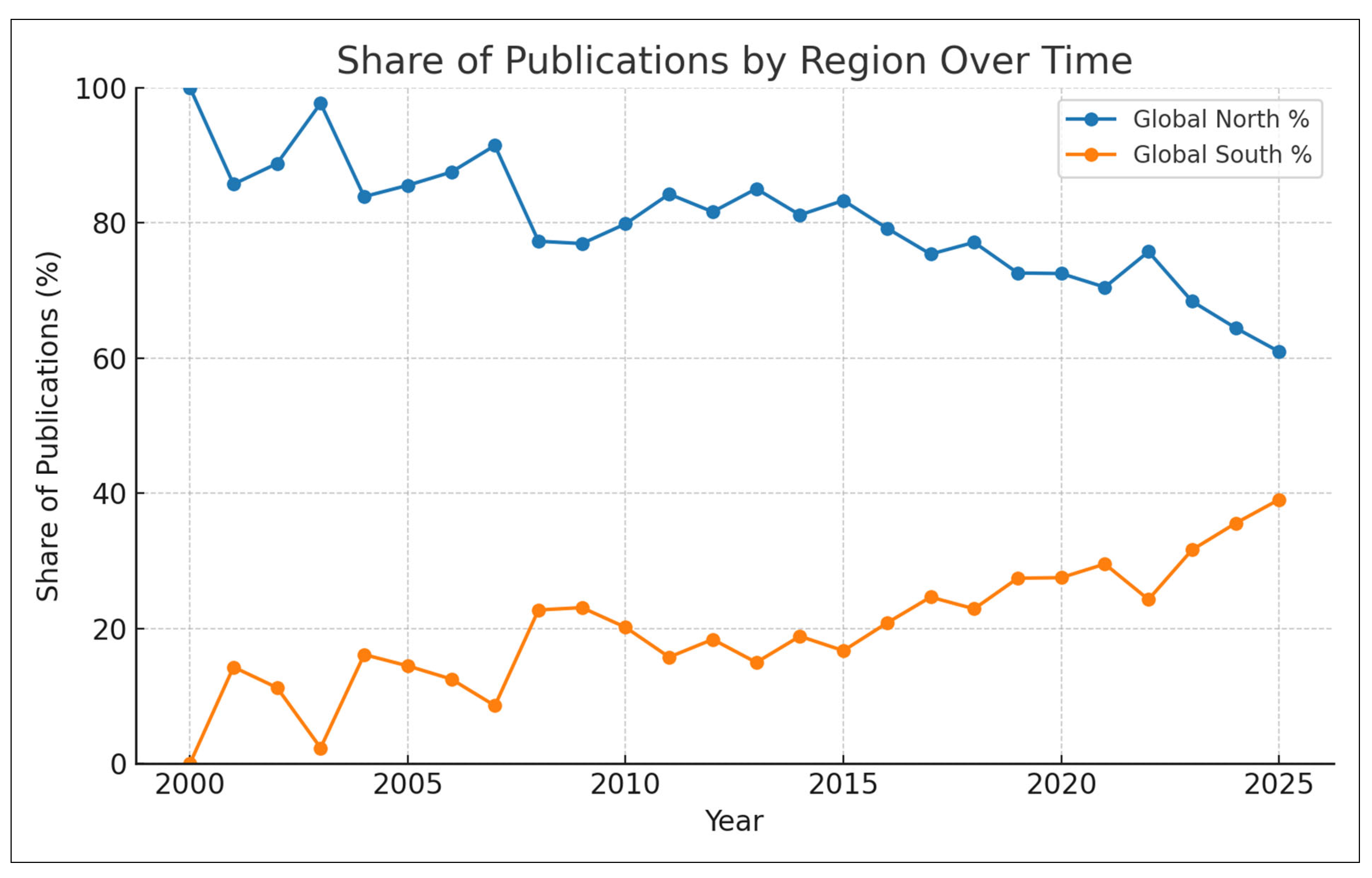
- Archaeological Earth observation research expanded nearly 1661% from 2000 to 2025, yet 78.9% of publications originate from Global North institutions, despite the Global South hosting the majority of UNESCO World Heritage Sites.
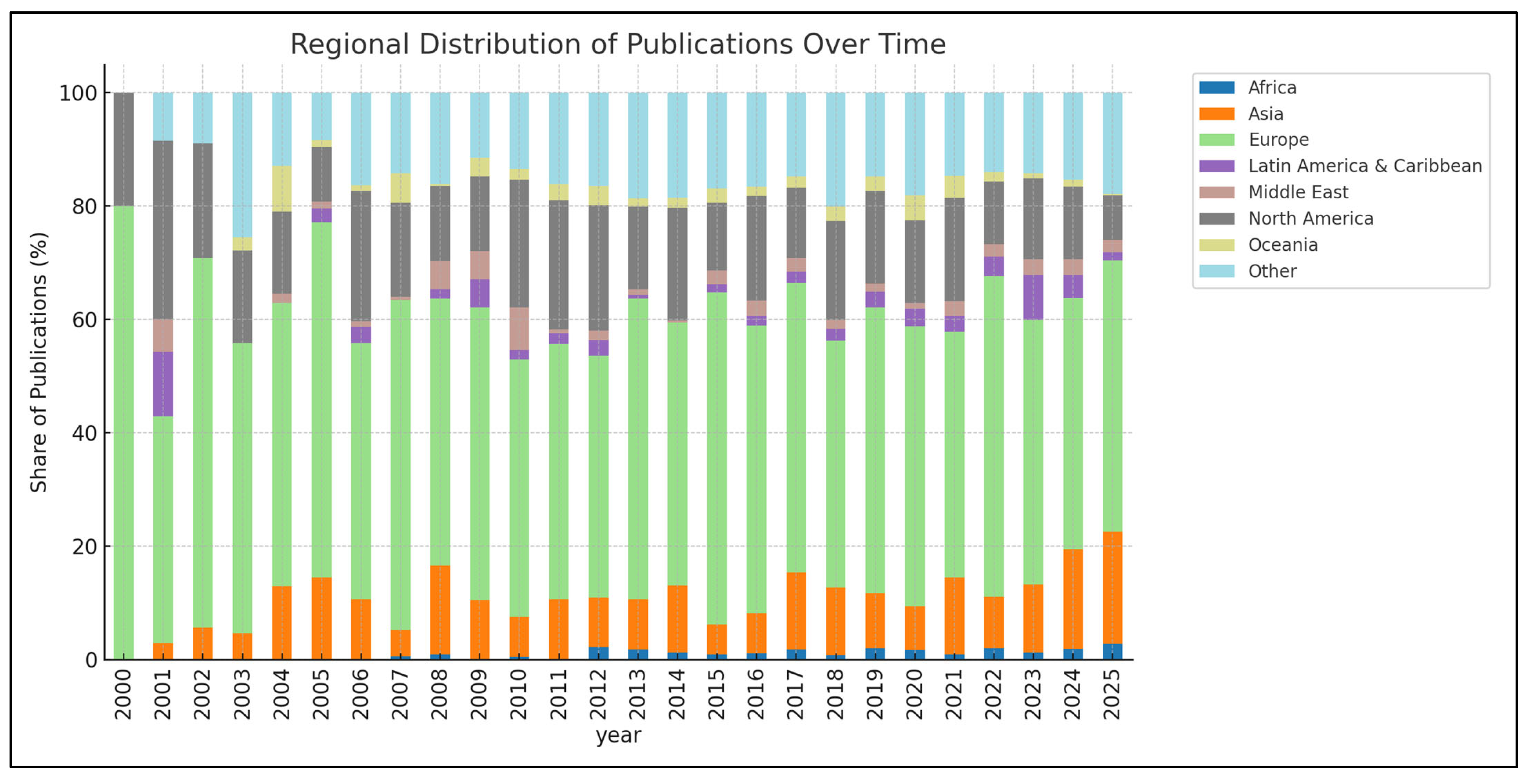
- A small group of countries (Italy, USA, UK) account for almost half of global out-put, while regions such as Sub-Saharan Africa remain critically un-der-represented (<1% of publications versus 9.4% of sites).
- This study demonstrates persistent structural inequalities in access to satellite data, computing infrastructure, and expertise, with implications for cultural her-itage protection and sustainable development.
- Redressing this imbalance requires coordinated capacity building, equitable data access, and inclusive frameworks that integrate Global South perspectives into Earth observation research.
Abstract
1. Introduction
2. Methodology
3. Results
3.1. Temporal Distribution and Research Evolution Patterns
3.2. Geographic Distribution and Regional Research Patterns
3.3. Regional Analysis and Global North–South Disparities
3.4. Technological and Methodological Evolution Patterns
4. Discussion
4.1. Advancing Fair Access to Heritage Protection Technologies
4.2. The European Model and the Acceleration Paradox
4.3. The Chinese Case Study
4.4. Pathways Toward Technological Justice
5. Conclusions
Funding
Data Availability Statement
Acknowledgments
Conflicts of Interest
References
- Lasaponara, R.; Masini, N. Satellite remote sensing in archaeology: Past, present and future perspectives. J. Archaeol. Sci. 2011, 38, 1995–2002. [Google Scholar] [CrossRef]
- Zingaro, M.; Scicchitano, G.; Capolongo, D. The Innovative growth of space archaeology: A brief overview of concepts and approaches in detection, monitoring, and promotion of the archaeological heritage. Remote Sens. 2023, 15, 3049. [Google Scholar] [CrossRef]
- Tapete, D. Remote sensing and geosciences for archaeology. Geosciences 2018, 8, 41. [Google Scholar] [CrossRef]
- Custer, J.F.; Eveleigh, T.; Klemas, V.; Wells, I. Application of Landsat data and synoptic remote sensing to predictive models for prehistoric archaeological sites: An example from the Delaware coastal plain. Am. Antiq. 1986, 51, 572–588. [Google Scholar] [CrossRef]
- Pope, K.O.; Dahlin, B.H. Ancient Maya wetland agriculture: New insights from ecological and remote sensing research. J. Field Archaeol. 1989, 16, 87–106. [Google Scholar] [CrossRef]
- Sever, T.L. Remote Sensing Applications in Archeological Research: Tracing Prehistoric Human Impact Upon the Environment; University of Colorado at Boulder: Boulder, CO, USA, 1990. [Google Scholar]
- Sever, T.L.; Irwin, D.E. Landscape archaeology: Remote-sensing investigation of the ancient Maya in the Peten rainforest of northern Guatemala. Anc. Mesoam. 2003, 14, 113–122. [Google Scholar] [CrossRef]
- Campana, S.R. Remote sensing in archaeology. In Encyclopedia of Geoarchaeology; Springer International Publishing: Cham, Switzerland, 2023; pp. 1–25. [Google Scholar]
- Agapiou, A.; Lysandrou, V. Remote sensing archaeology: Tracking and mapping evolution in European scientific literature from 1999 to 2015. J. Archaeol. Sci. Rep. 2015, 4, 192–200. [Google Scholar] [CrossRef]
- Opitz, R.; Herrmann, J. Recent trends and long-standing problems in archaeological remote sensing. J. Comput. Appl. Archaeol. 2018, 1, 19–41. [Google Scholar] [CrossRef]
- Evans, D.; Traviglia, A. Uncovering Angkor: Integrated remote sensing applications in the archaeology of early Cambodia. In Satellite Remote Sensing; Springer: Dordrecht, The Netherlands, 2012; pp. 197–230. [Google Scholar]
- Lasaponara, R.; Masini, N. Remote sensing in archaeology: From visual data interpretation to digital data manipulation. In Satellite Remote Sensing; Springer: Dordrecht, The Netherlands, 2012; pp. 3–16. [Google Scholar]
- Luo, L.; Wang, X.; Guo, H.; Lasaponara, R.; Zong, X.; Masini, N.; Wang, G.; Shi, P.; Khatteli, H.; Chen, F.; et al. Airborne and spaceborne remote sensing for archaeological and cultural heritage applications: A review of the century (1907–2017). Remote Sens. Environ. 2019, 232, 111280. [Google Scholar] [CrossRef]
- Stewart, C.; Lasaponara, R.; Schiavon, G. ALOS PALSAR analysis of the archaeological site of Pelusium in the Eastern Nile Delta (Egypt). Archaeol. Prospect. 2016, 23, 109–116. [Google Scholar]
- Agapiou, A. Remote sensing heritage in a petabyte-scale: Satellite data and heritage Earth Engine© applications. Int. J. Digit. Earth 2017, 10, 85–102. [Google Scholar] [CrossRef]
- Gorelick, N.; Hancher, M.; Dixon, M.; Ilyushchenko, S.; Thau, D.; Moore, R. Google Earth Engine: Planetary-scale geospatial analysis for everyone. Remote Sens. Environ. 2017, 202, 18–27. [Google Scholar] [CrossRef]
- Fu, D.; Xiao, H.; Su, F.; Zhou, C.; Dong, J.; Zeng, Y.; Yan, K.; Li, S.; Wu, J.; Wu, W.; et al. Remote sensing cloud computing platform development and Earth science application. Natl. Remote Sens. Bull. 2021, 25, 220–230. [Google Scholar] [CrossRef]
- Luo, L.; Wang, X.; Guo, H.; Jia, X.; Fan, A. Earth observation in archaeology: A brief review. Int. J. Appl. Earth Obs. Geoinform. 2023, 116, 103169. [Google Scholar] [CrossRef]
- Fisher, M.; Fradley, M.; Flohr, P.; Rouhani, B.; Simi, F. Ethical considerations for remote sensing and open data in relation to the endangered archaeology in the Middle East and North Africa project. Archaeol. Prospect. 2021, 28, 279–292. [Google Scholar] [CrossRef]
- Davis, D.S.; Buffa, D.; Rasolondrainy, T.; Creswell, E.; Anyanwu, C.; Ibirogba, A.; Randolph, C.; Ouarghidi, A.; Phelps, L.N.; Lahiniriko, F.; et al. The aerial panopticon and the ethics of archaeological remote sensing in sacred cultural spaces. Archaeol. Prospect. 2021, 28, 305–320. [Google Scholar] [CrossRef]
- Davis, D.S. Geographic disparity in machine intelligence approaches for archaeological remote sensing research. Remote Sens. 2020, 12, 921. [Google Scholar] [CrossRef]
- Matás, G.J.L.; Lim, J.S. Monumental funerary landscapes of Dhar Tagant (south-eastern Mauritania): Towards ethical satellite remote sensing in the West African Sahel. Archaeol. Prospect. 2021, 28, 357–378. [Google Scholar] [CrossRef]
- Mahler, A.G. What/Where is the Global South? In Oxford Bibliographies in Literary and Critical Theory; O’Brien, E., Ed.; Oxford University Press: Oxford, UK, 2017; Available online: https://www.globalsouthstudies.org/what-is-the-global-south/ (accessed on 30 August 2025).
- Joyce, K.E.; Nakalembe, C.L.; Gómez, C.; Suresh, G.; Fickas, K.; Halabisky, M.; Kalamandeen, M.; Crowley, M.A. Discovering Inclusivity in Remote Sensing: Leaving No One Behind. Front. Remote Sens. 2022, 3, 869291. [Google Scholar] [CrossRef]
- Thorpe, D. Dependent or not? From a daily practice of Earth observation research in the Global South to promoting adequate developmental spaces in science and technology studies. Geogr. Helv. 2023, 78, 105–130. [Google Scholar] [CrossRef]
- Woodcock, C.E.; Allen, R.; Anderson, M.; Belward, A.; Bindschadler, R.; Cohen, W.; Gao, F.; Goward, S.N.; Helder, D.; Helmer, E.; et al. Free Access to Landsat Imagery. Science 2008, 320, 1011. [Google Scholar] [CrossRef] [PubMed]
- Karnieli, A.; Berk, A.; Bayarjargal, Y. Remote Sensing and Geospatial Analysis in the Big Data Era: A Survey. Remote. Sens. 2024, 17, 550. [Google Scholar] [CrossRef]
- Wulder, M.A.; Coops, N.C. Satellites: Make Earth observations open access. Nature 2014, 513, 30–31. [Google Scholar] [CrossRef] [PubMed]
- Rouhani, B. From Ruins to Records: Digital Strategies and Dilemmas in Cultural Heritage Protection. In Digital Colonialism and Heritage Documentation; Routledge: Oxfordshire, UK, 2025; pp. 242–257. [Google Scholar]
- Meskell, L. A Future in Ruins: UNESCO, World Heritage, and the Dream of Peace; Oxford University Press: Oxford, UK, 2018. [Google Scholar]
- UNESCO World Heritage Centre. World Heritage List. 2024. Available online: https://whc.unesco.org/en/list/ (accessed on 24 August 2024).
- Casana, J. Emerging approaches to archaeological remote sensing. Adv. Archaeol. Pract. 2021, 9, 510–523. [Google Scholar] [CrossRef]
- Parcak, S. Archaeology from Space: How the Future Shapes Our Past; Henry Holt and Co.: New York, NY, USA, 2019. [Google Scholar]
- Comer, D.C.; Blakely, R.J. Global heritage in a digital age. J. Cult. Herit. 2020, 41, 224–231. [Google Scholar] [CrossRef]
- Davis, D.S.; Douglass, K. Aerial and spaceborne remote sensing in African archaeology: A review of current research and potential future avenues. Spat. Approaches Afr. Archaeol. 2020, 37, 9–24. [Google Scholar] [CrossRef]
- Tapete, D.; Cigna, F. Trends and perspectives of space-borne SAR remote sensing for archaeological landscape monitoring. J. Archaeol. Sci. Rep. 2019, 25, 513–525. [Google Scholar] [CrossRef]
- Forte, M.; Campana, S. Digital Methods and Remote Sensing in Archaeology: Archaeology in the Age of Sensing; Springer: Berlin/Heidelberg, Germany, 2019. [Google Scholar]
- UNESCO. Heritage Emergency Fund: Annual Progress Report 2023; UNESCO: Paris, France, 2023; Available online: https://docs.un.org/en/A/78/217 (accessed on 30 August 2025).
- UNESCO. Priority Africa: World Heritage Capacity-Building Strategy for Africa; UNESCO World Heritage Centre: Paris, Italy, 2023; Available online: https://whc.unesco.org/document/199636 (accessed on 30 August 2025).
- UNESCO. Operational Guidelines for the Implementation of the World Heritage Convention; UNESCO World Heritage Centre: Paris, France, 2022; Available online: https://icomos.es/wp-content/uploads/2024/04/document-57-39.pdf (accessed on 30 August 2025).
- Rouhani, B. Training in Endangered Archaeology: From Digital Documentation to Empowering National Heritage Stakeholders in the Middle East and North Africa. 2018. Available online: https://publ.icomos.org/publicomos/jlbSai?html=Pag&page=Pml/Not&base=technica&ref=6B9D268B4AD3835AB2B87534065A8AEE (accessed on 30 August 2025).
- Menéndez-Marsh, F.; Al-Rawi, M.; Fonte, J.; Dias, R.; Gonçalves, L.J.; Seco, L.G.; Neves, A. Geographic information systems in archaeology: A systematic review. J. Comput. Appl. Archaeol. 2023, 6, 40–50. [Google Scholar] [CrossRef]
- Trier, Ø.D.; Cowley, D.C.; Waldeland, A.U. Using deep neural networks on airborne laser scanning data: Results from a case study of semi-automatic mapping of archaeological topography on Arran, Scotland. Archaeol. Prospect. 2019, 26, 165–175. [Google Scholar] [CrossRef]
- Orengo, H.; Garcia-Molsosa, A. A brave new world for archaeological survey: Automated machine learning-based potsherd detection using high-resolution drone imagery. J. Archaeol. Sci. 2019, 112, 105013. [Google Scholar] [CrossRef]
- Bickler, S.H. Machine learning arrives in archaeology, but when do computers see like an archaeologist? Adv. Archaeol. Pract. 2021, 9, 122–136. [Google Scholar] [CrossRef]
- Davis, D.S. Object-based image analysis: A review of developments and future directions of automated feature detection in landscape archaeology. Archaeol. Prospect. 2019, 26, 155–163. [Google Scholar] [CrossRef]
- Soroush, M.; Mehrtash, A.; Khazraee, E.; Ur, J.A. Deep Learning in Archaeological Remote Sensing: Automated Qanat Detection in the Kurdistan Region of Iraq. Remote Sens. 2020, 12, 500. [Google Scholar] [CrossRef]
- Verschoof-van der Vaart, W.B.; Lambers, K. Automated detection of archaeological objects from remotely sensed data using machine learning: A review of progress and challenges. J. Archaeol. Sci. 2021, 133, 105428. [Google Scholar]
- Argyrou, A.; Agapiou, A. A review of artificial intelligence and remote sensing for archaeological research. Remote Sens. 2022, 14, 6000. [Google Scholar] [CrossRef]
- Kadhim, I.; Abed, F.M. A critical review of remote sensing approaches and deep learning techniques in archaeology. Sensors 2023, 23, 2918. [Google Scholar] [CrossRef]
- LeCun, Y.; Bengio, Y.; Hinton, G. Deep learning. Nature 2015, 521, 436–444. [Google Scholar] [CrossRef]
- Casana, J. Global-scale archaeological prospection using machine learning on satellite imagery. Proc. Natl. Acad. Sci. USA 2020, 117, 8554–8562. [Google Scholar]
- Somrak, M.; Džeroski, S.; Kokalj, Ž. Learning to classify structures in ALS-derived visualizations of ancient Maya settlements with CNN. Remote Sens. 2020, 12, 2215. [Google Scholar] [CrossRef]
- Kokalj, Ž.; Žiberna, A.; Briese, C.; Doneus, M. Machine learning-ready remote sensing data for Maya archaeology. Sci. Data 2023, 10, 24. [Google Scholar] [CrossRef]
- Aria, M.; Cuccurullo, C. bibliometrix: An R-tool for comprehensive science mapping analysis. J. Informetr. 2017, 11, 959–975. [Google Scholar] [CrossRef]
- Van Eck, N.J.; Waltman, L. Visualizing bibliometric networks. In Measuring Scholarly Impact; Springer International Publishing: Cham, Switzerland, 2014; pp. 285–320. [Google Scholar]
- Baas, J.; Schotten, M.; Plume, A.; Côté, G.; Karimi, R. Scopus as a curated, high-quality bibliometric data source for academic research in quantitative science studies. Quant. Sci. Stud. 2020, 1, 377–386. [Google Scholar] [CrossRef]
- Mongeon, P.; Paul-Hus, A. The journal coverage of Web of Science and Scopus: A comparative analysis. Scientometrics 2016, 106, 213–228. [Google Scholar] [CrossRef]
- Bramer, W.M.; Rethlefsen, M.L.; Kleijnen, J.; Franco, O.H. Optimal database combinations for literature searches in systematic reviews: A prospective exploratory study. Syst. Rev. 2017, 6, 1–12. [Google Scholar] [CrossRef]
- Lefebvre, C.; Glanville, J.; Briscoe, S.; Littlewood, A.; Marshall, C.; Metzendorf, M.I.; Noel-Storr, A.; Rader, T.; Shokraneh, F.; Thomas, J.; et al. Searching for and selecting studies. In Cochrane Handbook for Systematic Reviews of Interventions; John Wiley & Sons: Chichester, UK, 2019; pp. 67–107. [Google Scholar]
- Page, M.J.; McKenzie, J.E.; Bossuyt, P.M.; Boutron, I.; Hoffmann, T.C.; Mulrow, C.D.; Shamseer, L.; Tetzlaff, J.M.; Akl, E.A.; Brennan, S.E.; et al. The PRISMA 2020 statement: An updated guideline for reporting systematic reviews. BMJ 2021, 372, n71. [Google Scholar] [CrossRef]
- Drusch, M.; Del Bello, U.; Carlier, S.; Colin, O.; Fernandez, V.; Gascon, F.; Hoersch, B.; Isola, C.; Laberinti, P.; Martimort, P.; et al. Sentinel-2: ESA’s Optical High-Resolution Mission for GMES Operational Services. Remote Sens. Environ. 2012, 120, 25–36. [Google Scholar] [CrossRef]
- Wulder, M.A.; Loveland, T.R.; Roy, D.P.; Crawford, C.J.; Masek, J.G.; Woodcock, C.E.; Allen, R.G.; Anderson, M.C.; Belward, A.S.; Cohen, W.B.; et al. Current status of Landsat program, science, and applications. Remote Sens. Environ. 2019, 225, 127–147. [Google Scholar] [CrossRef]
- Malenovský, Z.; Rott, H.; Cihlar, J.; Schaepman, M.E.; García-Santos, G.; Fernandes, R.; Berger, M. Sentinels for science: Potential of Sentinel-1, -2, and -3 missions for scientific observations of ocean, cryosphere, and land. Remote Sens. Environ. 2012, 120, 91–101. [Google Scholar] [CrossRef]
- Abate, N.; Lasaponara, R. Preventive archaeology based on open remote sensing data and tools: The cases of Sant’Arsenio (SA) and Foggia (FG), Italy. Sustainability 2019, 11, 4145. [Google Scholar] [CrossRef]
- Agapiou, A.; Hegyi, A.; Gogâltan, F.; Stavilă, A.; Sava, V.; Sarris, A.; Floca, C.; Dorogostaisky, L. Exploring the largest known Bronze Age earthworks in Europe through medium resolution multispectral satellite images. Int. J. Appl. Earth Obs. Geoinform. 2023, 118, 103239. [Google Scholar] [CrossRef]
- Roy, D.P.; Wulder, M.A.; Loveland, T.R.; Woodcock, C.E.; Allen, R.G.; Anderson, M.C.; Helder, D.; Irons, J.R.; Johnson, D.M.; Kennedy, R.; et al. Landsat-8: Science and product vision for terrestrial global change research. Remote Sens. Environ. 2014, 145, 154–172. [Google Scholar] [CrossRef]
- DigitalGlobe. WorldView-3 Data Sheet (Instrument & SWIR Specifications). 2014. Available online: https://www.spaceimagingme.com/downloads/sensors/datasheets/DG_WorldView3_DS_2014.pdf (accessed on 30 August 2025).
- Planet Team. Planet Application Program Interface: In Space for Life on Earth; Planet Team: San Francisco, CA, USA, 2017. [Google Scholar]
- Torres, R.; Snoeij, P.; Geudtner, D.; Bibby, D.; Davidson, M.; Attema, E.; Potin, P.; Rommen, B.; Floury, N.; Brown, M.; et al. GMES Sentinel-1 mission. Remote Sens. Environ. 2012, 120, 9–24. [Google Scholar] [CrossRef]
- Werninghaus, R.; Buckreuss, S. The TerraSAR-X mission and system design. IEEE Trans. Geosci. Remote Sens. 2010, 48, 606–614. [Google Scholar] [CrossRef]
- Covello, F.; Battazza, F.; Coletta, A.; Lopinto, E.; Fiorentino, C.; Pietranera, L.; Valentini, G.; Zoffoli, S. The COSMO-SkyMed Mission: A SAR Constellation for Earth Observation. IGARSS/IEEE TGRS (Mission Overview). 2010. Available online: https://hal.science/hal-00615310/document (accessed on 30 August 2025).
- Covello, F.; Battazza, F.; Coletta, A.; Zoffoli, S. COSMO-SkyMed mission status. In Proceedings of the EUSAR 2018; 12th European Conference on Synthetic Aperture Radar, Aachen, Germany, 4–7 June 2018. [Google Scholar]
- Yamaguchi, Y.; Kahle, A.; Tsu, H.; Kawakami, T.; Pniel, M. Overview of Advanced Spaceborne Thermal Emission and Reflection Radiometerinstrument. IEEE Trans. Geosci. Remote Sens. 1998, 36, 1062–1071. [Google Scholar] [CrossRef]
- Guarini, R.; Loizzo, R.; Facchinetti, C.; Longo, F.; Ponticelli, B.; Faraci, M.; Dami, M.; Cosi, M.; Amoruso, L.; De Pasquale, V.; et al. Prisma Hyperspectral Mission Products. In Proceedings of the IGARSS 2018—2018 IEEE International Geoscience and Remote Sensing Symposium, Valencia, Spain, 22–27 July 2018; pp. 179–182. [Google Scholar]
- Shaik, R.U.; Periasamy, S.; Zeng, W. Potential Assessment of PRISMA Hyperspectral Imagery for Remote Sensing Applications. Remote Sens. 2023, 15, 1378. [Google Scholar] [CrossRef]
- Guanter, L.; Kaufmann, H.; Segl, K.; Foerster, S.; Rogass, C.; Chabrillat, S.; Kuester, T.; Hollstein, A.; Rossner, G.; Chlebek, C.; et al. The EnMAP Spaceborne Imaging Spectroscopy Mission for Earth Observation. Remote Sens. 2015, 7, 8830–8857. [Google Scholar] [CrossRef]
- Farr, T.G.; Rosen, P.A.; Caro, E.; Crippen, R.; Duren, R.; Hensley, S.; Kobrick, M.; Paller, M.; Rodriguez, E.; Roth, L.; et al. The Shuttle Radar Topography Mission. Rev. Geophys. 2007, 45, RG2004. [Google Scholar] [CrossRef]
- Krieger, G.; Zink, M.; Bachmann, M.; Bräutigam, B.; Schulze, D.; Martone, M.; Rizzoli, P.; Steinbrecher, U.; Antony, J.W.; De Zan, F.; et al. TanDEM-X: A radar interferometer with two formation-flying satellites. Acta Astronaut. 2013, 89, 83–98. [Google Scholar] [CrossRef]
- Casana, J.; Cothren, J. Stereo analysis, DEM extraction and orthorectification of CORONA satellite imagery: Archaeological applications from the Near East. Antiquity 2008, 82, 732–749. [Google Scholar] [CrossRef]
- Agapiou, A. Land cover mapping from colorized CORONA archived greyscale satellite data and feature extraction classification. Land 2021, 10, 771. [Google Scholar] [CrossRef]
- Chirikure, S. Heritage conservation in Africa: The good, the bad, and the challenges. S. Afr. J. Sci. 2013, 109, 1–3. [Google Scholar] [CrossRef]
- Brooks, N.; Clarke, J.; Ngaruiya, G.W.; Wangui, E.E. African heritage in a changing climate. Azania Archaeol. Res. Afr. 2020, 55, 297–328. [Google Scholar] [CrossRef]
- Sesay, A.; Olusola, O.K.; Omotosho, M. Africa and South–South cooperation: Opportunities and challenges. In The Rise of the Global South: Philosophical, Geopolitical and Economic Trends of the 21st Century; World Scientific Publishing Co. Pte. Ltd.: Singapore, 2013; pp. 95–123. [Google Scholar]
- SERVIR Amazonia. SERVIR Amazonia: Connecting Space to Village. 2023. Available online: https://servir.ciat.cgiar.org/ (accessed on 30 August 2025).
- Asante, K.O.; Macuácua, E.; Mutanga, O. Capacity building in Earth Observation: Experiences from GMES & Africa. Remote. Sens. Appl. Soc. Environ. 2021, 23, 100546. [Google Scholar] [CrossRef]
- Landauer, J.; Klassen, S.; Wijker, A.P.; van der Kroon, J.; Jaszkowski, A.; der Vaart, W.B.V.-V. Beyond the Greater Angkor Region: Automatic Large-Scale Mapping of Angkorian-Period Reservoirs in Satellite Imagery Using Deep Learning. PLoS ONE 2025, 20, e0320452. [Google Scholar] [CrossRef] [PubMed]
- Sobotkova, A.; Kristensen-McLachlan, R.D.; Mallon, O.; Ross, S.A. Validating Predictions of Burial Mounds with Field Data: The Promise and Reality of Machine Learning. J. Doc. 2024, 80, 1167–1189. [Google Scholar] [CrossRef]
- Fylaktos, P.; Petropoulos, G.P.; Lemesios, I. A Deep Learning Method for the Automated Mapping of Archaeological Structures from Geospatial Data: A Case Study of Delos Island. ISPRS Int. J. Geo-Inform. 2025, 14, 220. [Google Scholar] [CrossRef]
- Chen, F.; Lasaponara, R.; Masini, N. An overview of satellite synthetic aperture radar remote sensing in archaeology: From site detection to monitoring. J. Cult. Heritage 2017, 23, 5–11. [Google Scholar] [CrossRef]
- Bewley, R. Endangered archaeology in the Middle East and North Africa (EAMENA): Approach and possible solutions. In Post-Conflict Archaeology and Cultural Heritage; Routledge: New York, NY, USA, 2017; pp. 123–137. [Google Scholar]
- Cuca, B. The contribution of earth observation technologies to monitoring strategies of cultural landscapes and sites. Int. Arch. Photogramm. Remote Sens. Spat. Inf. Sci. 2017, 42, 135–140. [Google Scholar] [CrossRef]
- Xiao, W.; Mills, J.; Guidi, G.; Rodríguez-Gonzálvez, P.; Barsanti, S.G.; González-Aguilera, D. Geoinformatics for the conservation and promotion of cultural heritage in support of the UN Sustainable Development Goals. ISPRS J. Photogramm. Remote Sens. 2018, 142, 389–406. [Google Scholar] [CrossRef]
- Anderson, K.; Ryan, B.; Sonntag, W.; Kavvada, A.; Friedl, L. Earth observation in service of the 2030 Agenda for Sustainable Development. Geo-Spat. Inf. Sci. 2017, 20, 77–96. [Google Scholar] [CrossRef]
- Chen, F.; Zhou, W.; Xu, H.; Parcharidis, I.N.; Lin, H.; Fang, C. Space technology facilitates the preventive monitoring and preservation of the Great Wall of the Ming dynasty: A comparative study of the Qingtongxia and Zhangjiakou sections in China. IEEE J. Sel. Top. Appl. Earth Obs. Remote Sens. 2020, 13, 5719–5729. [Google Scholar] [CrossRef]
- Moise, C.; Lazar, A.-M.; Mihalache, C.E.; Dedulescu, L.A.; Negula, I.F.D.; Badea, A.; Poenaru, V.D.; Moise, R.; Ortan, A.R. Geomatics Technologies in the Framework of Multidisciplinary Project for Integrated Management of Cultural Heritage Sites. Int. Arch. Photogramm. Remote Sens. Spat. Inf. Sci. 2020, 46, 1477–1484. [Google Scholar] [CrossRef]
- Cannelli, S.; de Veld, F.; Gehlot, M.; Nugent, T.K.; Thangavel, K. Earth’s orbits as a UNESCO World Heritage Site. In Proceedings of the 74th International Astronautical Congress, Baku, Azerbaijan, 2–6 October 2023. [Google Scholar]
- Agapiou, A.; Lysandrou, V.; Cuca, B. Copernicus Earth Observation for Cultural Heritage. In Proceedings of the Joint International Event 9th ARQUEOLÓGICA 2.0 & 3rd GEORES, Valencia, Spain, 26–28 April 2021; pp. 259–266. [Google Scholar]
- Zhong, Q.; Luo, J.; Fang, J.; Chen, Y. Two-stage cascaded vision transformer with spatial attention for dense settlement detection in remote sensing imagery. npj Heritage Sci. 2025, 13, 211. [Google Scholar] [CrossRef]



| Query Focus | Records | Percentage | Coverage | Research Emphasis |
|---|---|---|---|---|
| Core Remote Sensing Q1 | 4573 | 92.2% | Comprehensive | Traditional methods |
| AI/ML Applications Q2 | 272 | 5.5% | Advanced techniques | Computational methods |
| Geographic Disparities Q3 | 44 | 0.9% | Critical perspectives | Social analysis |
| Heritage Management Q4 | 72 | 1.4% | Practical applications | Implementation focus |
| Combined Total | 4961 | 100% |
| Period | Archaeologically Relevant Publications | % | Growth Rate | EO Overall Publications | EO Overall % | EO Overall Growth Rate |
|---|---|---|---|---|---|---|
| 2000–2004 | 117 | 2.7% | Baseline | 13,551 | 7.8% | Baseline |
| 2005–2009 | 396 | 9.1% | +238.5% | 20,345 | 11.7% | +50.1% |
| 2010–2014 | 658 | 15.1% | +66.2% | 28,117 | 16.2% | +38.2% |
| 2015–2019 | 1129 | 25.9% | +71.6% | 39,007 | 22.5% | +38.7% |
| 2020–2025 | 2059 | 47.2% | +82.4% | 72,454 | 41.8% | +85.7% |
| Total | 4359 | 100% | +3625.6% | 173,474 | 100% | +1180.2% |
| Country | Publications | Percentage | Regional Position | Country | Publications | % of EO Overall | Regional Position |
|---|---|---|---|---|---|---|---|
| Italy | 886 | 20.3% | Europe leader | United States | 45,133 | 17.4% | North America leader |
| United States | 726 | 16.7% | North America leader | China | 44,247 | 17.0% | East Asia leader |
| United Kingdom | 438 | 10.0% | Europe major | Germany | 14,598 | 5.6% | Europe leader |
| China | 380 | 8.7% | East Asia leader | United Kingdom | 11,990 | 4.6% | Europe major |
| Germany | 319 | 7.3% | Europe major | France | 11,763 | 4.5% | Europe major |
| Spain | 289 | 6.6% | Iberian leader | Italy | 11,077 | 4.3% | Europe major |
| France | 250 | 5.7% | Europe major | India | 10,537 | 4.1% | South Asia leader |
| Greece | 187 | 4.3% | Mediterranean focus | Japan | 9031 | 3.5% | East Asia major |
| Australia | 142 | 3.3% | Oceania leader | Canada | 7073 | 2.7% | North America secondary |
| Canada | 120 | 2.8% | North America secondary | Russian Federation | 7041 | 2.7% | Eastern Europe/Eurasia |
| Region | Publications | Percentage | World Heritage Sites | Research Intensity |
|---|---|---|---|---|
| Global North | ||||
| North America | 607 | 13.9% | 45 (3.6%) | Very High |
| Europe | 2663 | 61.1% | 492 (39.4%) | High |
| Developed Asia-Pacific | 168 | 3.9% | 66 (5.3%) | Low |
| Global North Total | 3438 | 78.9% | 603 (48.3%) | |
| Global South | ||||
| China | 339 | 7.8% | 60 (4.8%) | High |
| Other East Asia | 25 | 0.6% | 97 (7.8%) | Very Low |
| South Asia | 103 | 2.4% | 66 (5.3%) | Very Low |
| Middle East/North Africa | 204 | 4.7% | 151 (12.1%) | Very Low |
| Sub-Saharan Africa | 26 | 0.6% | 117 (9.4%) | Very Low |
| Latin America | 92 | 2.1% | 154 (12.3%) | Very Low |
| Global South Total | 789 | 18.1% | 645 (51.7%) |
Disclaimer/Publisher’s Note: The statements, opinions and data contained in all publications are solely those of the individual author(s) and contributor(s) and not of MDPI and/or the editor(s). MDPI and/or the editor(s) disclaim responsibility for any injury to people or property resulting from any ideas, methods, instructions or products referred to in the content. |
© 2025 by the author. Licensee MDPI, Basel, Switzerland. This article is an open access article distributed under the terms and conditions of the Creative Commons Attribution (CC BY) license (https://creativecommons.org/licenses/by/4.0/).
Share and Cite
Agapiou, A. Unequal Horizons: Global North–South Disparities in Archaeological Earth Observation (2000–2025). Remote Sens. 2025, 17, 3371. https://doi.org/10.3390/rs17193371
Agapiou A. Unequal Horizons: Global North–South Disparities in Archaeological Earth Observation (2000–2025). Remote Sensing. 2025; 17(19):3371. https://doi.org/10.3390/rs17193371
Chicago/Turabian StyleAgapiou, Athos. 2025. "Unequal Horizons: Global North–South Disparities in Archaeological Earth Observation (2000–2025)" Remote Sensing 17, no. 19: 3371. https://doi.org/10.3390/rs17193371
APA StyleAgapiou, A. (2025). Unequal Horizons: Global North–South Disparities in Archaeological Earth Observation (2000–2025). Remote Sensing, 17(19), 3371. https://doi.org/10.3390/rs17193371


