Abstract
Mapping marine habitats is fundamental for biodiversity conservation and ecosystem-based management in oceanic regions under increasing anthropogenic and climatic pressures. In the context of global initiatives—such as marine protected area expansion and international agreements—habitat mapping has become mandatory for regional and global conservation policies. It provides spatial data to delineate essential habitats, support connectivity analyses, and assess pressures, enabling ecosystem-based marine spatial planning aligned with EU directives (2008/56/EC; 2014/89/EU). Beyond biodiversity, macrophytes, rhodolith beds, and coral reefs deliver key ecosystem services—carbon sequestration, coastal protection, nursery functions, and fisheries support—essential to local socioeconomies. This systematic review (PRISMA guidelines) examined 69 peer-reviewed studies across Central-Eastern Atlantic archipelagos (Macaronesia: the Azores, Madeira, the Canaries, and Cabo Verde) and the Mid-Atlantic Ridge. We identified knowledge gaps, methodological trends, and key challenges, emphasizing the integration of cartographic, ecological, and technological approaches. Although methodologies diversified over time, the lack of survey standardization, limited ground truthing, and heterogeneous datasets constrained the production of high-resolution bionomic maps. Regional disparities persist in technology access and habitat coverage. The Azores showed the highest species richness (393), dominated by acoustic mapping in corals. Madeira was most advanced in the remote mapping of rhodoliths; the Canaries focused on shallow macrophytes with direct mapping; and Cabo Verde remains underrepresented. Harmonized protocols and regional cooperation are needed to improve data interoperability and predictive modeling.
1. Introduction
Continental shelves provide a diverse network of habitats that support numerous species [1,2,3] and hold significant ecological, economic, and social value. Their importance is especially demonstrated through key ecosystem services, such as blue carbon sequestration [4,5,6], habitat formation [7,8,9], and the preservation of fishing grounds and cultural activities [10,11,12,13,14]. These ecosystem services arise from various key habitats underpinned by “ecosystem engineers”, which not only provide resources and services, but also modify local conditions by creating, maintaining, or transforming habitats [15,16,17]. The complexity of these habitats—frequently found on continental shelves, slopes, and seamounts (in both hard and soft bottoms)—is related to their three-dimensionality, diversity, and arrangement of physical elements (rocks, crevices, organisms, etc.), and it largely determines the increased diversity and density of the species they support [18,19,20,21,22]. Consequently, habitat complexity is considered decisive in the structure and function of biological communities [23,24].
Key habitats include macrophyte beds and coral reefs [25,26,27,28,29] (Figure 1). Macrophyte beds encompass various habitats (e.g., macroalgal forests, rhodolith and seagrass seabeds), which function as submerged “forests”, offering protection and food for invertebrates and fish [30,31,32] (Figure 1). These habitats are known for their high primary production, biodiversity increases through “facilitation cascades” [14,16,33,34,35], and their role in carbon sequestration [2,16,17,36,37,38]. Rhodolith beds, in particular, consist of free-living, calcified red algae forming mobile nodules, creating unique habitats with high structural complexity over soft bare substrates. Rhodolith beds also play a significant role in biogeochemical cycling, acting as carbon sinks and contributing to the regulation of ocean acidity through carbonate production and dissolution [6,39,40]. Seagrass meadows play a crucial role in sediment retention, juvenile fish habitat provision, and carbon fixation (e.g., blue carbon) [16,17,36]. They significantly enhance water clarity and stabilize sediments, thereby protecting coastlines from erosion and storm impacts [41,42]. Coral reefs, found in both shallow and deep waters [43,44,45,46,47], form biogenic structures that provide shelter and breeding grounds for invertebrates and fish, further enhancing biodiversity [16,17,40]. They provide vital ecosystem services such as coastal protection, fisheries support, and opportunities for tourism and recreation, which are crucial for the livelihoods of coastal communities [48,49,50].
The high added value of these habitats to humans and the marine ecosystem, coupled with increasing pressures and threats, highlights the need to protect marine biodiversity while preserving essential ecosystem services [29,51,52,53,54,55]. Contemporary environmental management methodologies are shifting toward an ecosystem-based approach [56,57,58,59] that integrates all interactions related to the functioning of marine ecosystems—including anthropogenic systems—rather than addressing them in isolation [60,61,62]. Typical marine spatial planning (MSP) approaches include zoning schemes that combine strict conservation areas, supervised sustainable-use zones, and multiple-use areas, driven by EU directives such as the Maritime Spatial Planning Directive (Directive 2014/89/EU) and the Marine Strategy Framework Directive (MSFD, Directive 2008/56/EC) [63,64,65]. Effective MSP utilizes marine habitat mapping (MHM) data to identify critical habitats and their connectivity, facilitating informed decisions on marine conservation and sustainable resource use [66,67,68]. The implementation of this marine spatial management framework requires understanding multiple factors, such as ecosystem functioning and former inter- and intraspecific interactions [69,70,71,72]. In this context, accurate data on the distribution and extent of marine habitats are essential [66,73,74,75]. Effective management and conservation strategies rely on baseline geographic information, including habitat distribution patterns, connectivity, associated biodiversity [52,76,77,78], and the impacts of different pressures [2,79].
Habitat mapping is a crucial first step in the sustainable management of the marine environments, a field that remains largely unexplored due to financial, logistical, and technical challenges [2,52,61]. Historically, habitat mapping in Macaronesia (the Azores, Madeira, the Canary Islands, and Cabo Verde) has progressively developed through initiatives like the MarSP project (2018–2020) and cooperative networks such as EMODnet and OSPAR, enhancing the region’s scientific capacity and data availability for effective management [80,81,82]. Recent technological advancements in remote sensing, including acoustic and optical methods, have significantly improved habitat characterization accuracy and spatial resolution, overcoming historical limitations in data quality and coverage [66,83]. Traditionally, habitat assessment relied on direct sampling and observations [84,85]. However, advancements in remote sensing technologies, such as acoustic, satellite, and optical methods [17,36,52,86,87], allow for the characterization of physical and biological features over large areas with reduced logistical and economic efforts [88,89,90,91,92,93]. Consequently, habitat mapping underpins essential baseline data for effective coastal management and conservation policies, though limited ecological knowledge of many marine habitats continues to hinder management effectiveness [28,71,77,84,94] (Figure 1; Table A1).
The Lusitanian biogeographical province [95], known for its rich biodiversity, faces significant environmental pressures from climate change, tourism overdevelopment, coastal exploitation, and invasive species [96,97]. Specifically, coastal economic and urban development intensifies anthropogenic pressures, as a large portion of the global population resides and/or works in these areas [98,99,100,101,102]. These pressures are even more pronounced in insular territories, where coastal zones constitute a substantial part of the total land area [98,103], such as the case of the Central-Eastern Atlantic volcanic archipelagos of the Azores, Madeira, the Canary Islands, and Cabo Verde [40,104,105]. As insular systems, they exhibit high isolation shaping their marine biota [105,106]. These unique characteristics make them highly relevant in terms of their biogeography, ecology, evolution, and conservation biology, as they serve as natural laboratories for studying evolutionary and ecological processes [104,107,108]. However, these islands are particularly vulnerable to environmental change and human impact due to their isolation, their limited area, and the concentration of human activities along their coasts. This heightened vulnerability makes it essential to conduct focused scientific studies aimed at protecting their unique marine ecosystems. Such protection relies on acquiring detailed knowledge of the distribution and characteristics of marine habitats, which, in turn, depends on continued advancements in seabed mapping techniques [66,104,109,110,111]. In this context, the European Union has committed to protecting at least 30% of its marine surface by 2030 under the EU Biodiversity Strategy, with 10% under strict protection, thus reinforcing the legal and political urgency of advancing marine conservation [112]. The Macaronesian archipelagos are particularly relevant within this strategy, as they host vulnerable and ecologically valuable habitats—such as seagrass meadows, rhodolith beds, and coral reefs—that are essential for achieving ecological representativeness, connectivity, and effective conservation targets in European marine subregions [29,51,52,53,54,55,65,80].
This study aims to provide a comprehensive review of the current knowledge and gaps in mapping key habitats across the Central-Eastern Atlantic volcanic archipelagos. To achieve this, available mapping tools and methodologies were cataloged, their chronological use examined, and the challenges associated with their application across different habitats and depths analyzed. The review also identified knowledge gaps, such as understudied geographical areas and key habitats—both in terms of habitat type and taxonomy—highlighting regions with data scarcity that could hinder conservation efforts. Finally, recommendations were proposed to strengthen research initiatives and enhance the development of useful habitat mapping methodologies. In this sense, international cooperation will foster more effective decision-making processes in the framework of evolving marine spatial planning activities, where the marine conservation sector deserves a more intense focus.

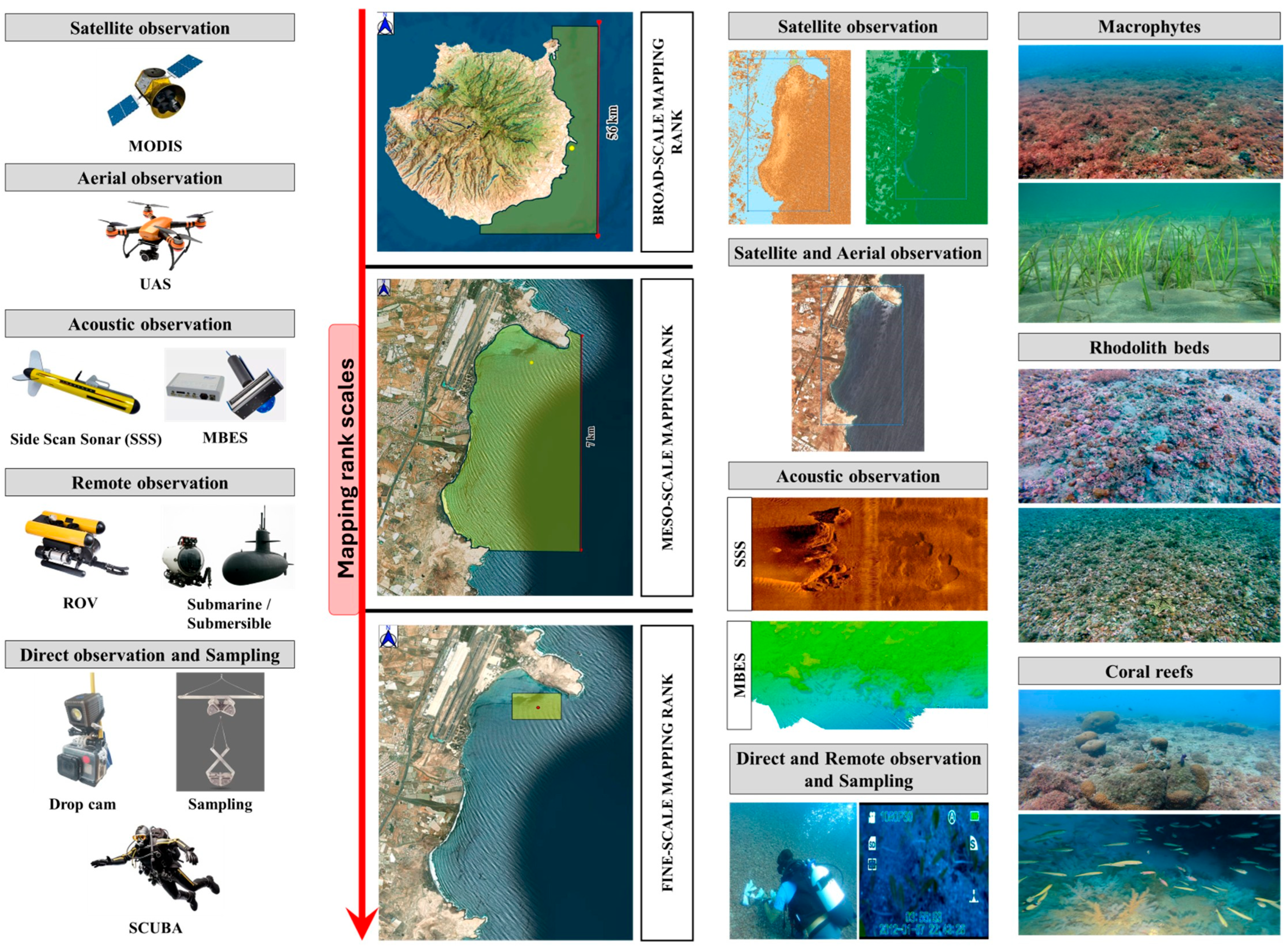
Figure 1.
Summary of main methodologies used for marine habitat mapping, organized by spatial coverage—from broad-scale to fine-scale approaches. These include satellite and aerial observation (e.g., moderate resolution imaging spectroradiometer [MODIS], unmanned aerial vehicles [UAVs]), acoustic techniques (e.g., side scan sonar [SSS], multibeam echosounder [MBES]), remote sensing (remotely operated vehicles [ROVs] and submersibles), and direct observation and sampling (e.g., SCUBA, drop cameras, dredges). Representative examples of the data generated by each methodology and the key habitats analyzed in this study are shown on the right. The figure was adapted from Van Rein et al. [113] MODIS database (https://modis.gsfc.nasa.gov/ accessed on 17 June 2025).
2. Materials and Methods
This systematic review was conducted following the guidelines of the Preferred Reporting Items for Systematic Reviews and Meta-Analyses (PRISMA), to ensure transparency, reproducibility, and comprehensiveness at each stage of the process, from sourcing and selection to the analysis of the selected articles [114,115,116].
2.1. Study Area
The study focuses on the four volcanic archipelagos located in the Central-Eastern Atlantic Ocean: the Azores, Madeira, the Canary Islands, and Cabo Verde. A section of the Mid-Atlantic Ridge within the Azores exclusive economic zone (EEZ) was also considered, as it plays a crucial role in ocean current dynamics and ecological connectivity among the four archipelagos (Figure 2; [117]).
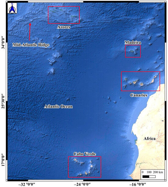
Figure 2.
Location of the study area in the Central-Eastern Atlantic Ocean, showing the study areas.
The marine study area covers the so-called European Macaronesian region [118]; the term Macaronesia (composed of two Greek words, makarion [fortunate] and neosi [islands]) has been used in the biogeographic literature to include the four archipelagos located in the Central-East North Atlantic Ocean: the Azores, Madeira (including the Selvagens Isles), the Canary Islands, and Cabo Verde. These oceanic archipelagos have a volcanic origin, as geological demonstrations of hotspots off Northwestern Africa with large depths found between adjacent islands. The biogeographic position of these European archipelagos encompasses a large macroclimatic gradient of almost 2500 km of latitudinal extension, from hyperoceanic temperate conditions in the Azores to Mediterranean to subtropical ecosystems in Madeira, the Selvagens, and the Canaries [119,120]. Their marine environments are mainly connected through the Canary Current, a branch of the Gulf Stream in the Eastern Atlantic moving down from the Azores through Madeira to the Canary Islands and further south to the Cape Verde Islands [121]. Recent biogeographical studies have shown a more isolated biogeographical position in the case of the Azores, whereas the marine biota of the three central archipelagos, Madeira, the Selvagens, and the Canary Islands, showed stronger affinities among them [122,123]; as a consequence, these three archipelagos defined a new biogeographical unit (Webbnesia) and the marine biota of the southernmost archipelago of Cabo Verde is considered as part of the West African Transition province [124].
Aside from their common volcanic origin, these archipelagos exhibit a high degree of endemism in the terrestrial realm, underscoring their worldwide biogeographic significance [117,125] and including marked differences in both terrestrial and coastal habitats. The Azores, Madeira, and the Canary Islands, located at more northerly latitudes, display temperate and subtropical oceanic climates alongside rugged coastlines featuring rocky reefs that support a range of benthic communities. Their coasts range from volcanic cliffs to sandy beaches and emergent rock outcrops, which foster highly diverse marine habitats encompassing seagrass beds, macroalgal assemblages on rocky reefs, and cold-water coral reefs (CWC) [117,126,127]. Conversely, Cabo Verde is situated in a dry subtropical zone, characterized by a warmer and more arid climate, where marine ecosystems are dominated by sedimentary seabeds (sandy and muddy), followed by rocky and coral reefs, and their biota differs in composition from that of the more northerly islands [128].
2.2. Data Sources and Search Strategies
The literature collection was conducted in two primary databases, SciVerse Scopus and ISI Web of Science, with Google Scholar as a supplementary source. These platforms were selected for their extensive coverage and ability to capture relevant publications on cartography and mapping in the different oceanic archipelagos of the Central-Eastern Atlantic Ocean.
Due to the inconsistency and variability in the terminology used across the scientific literature to describe this study region, we have adopted an inclusive approach by referencing all historically and currently accepted designations. In addition to the term Central-Atlantic Islands, we use the widely recognized expressions Macaronesia (as per the biogeographic classification of Spalding et al. [95] and Webbnesia [124], as well as the explicit naming of the four constituent archipelagos: the Azores, Madeira, the Canary Islands, and Cape Verde. As indicated in the second paragraph of the Study area section, the scope of this study is geographically defined within the region traditionally known as Macaronesia, ensuring consistency with the biogeographical frameworks adopted in previous reviews.
The search strategy was carefully designed and executed in December 2024. A Boolean sequence of search terms was developed, using synonyms and related terms aligned with the main objective of the study. As shown in Table 1, each column represented a set of similar terms combined using the “OR” logic, while different columns were linked using the “AND” logic. Wildcard characters (*) were applied to account for variations in term usage (e.g., “canar*” retrieves for canaries, canary, and canarias). The complete search formula is available in the Supplementary Materials. In the Web of Science, the TS= operator was used in the search equation, while in Scopus, a similar logic was applied by adapting the TS= to TITLE-ABS-KEY=. In both, filters were applied to exclude non-relevant subject areas, such as medicine, arts, and physical–chemical–mathematical sciences.

Table 1.
Search terms for the systematic review.
2.3. Inclusion and Exclusion Criteria
To ensure the quality and relevance of the selected studies, rigorous “inclusion” and “exclusion” criteria were established. Studies addressing cartography and providing spatial data were included, even if explicit maps were absent. Reviews containing maps or spatial data, as well as studies focused on one or more Central-Eastern Atlantic archipelagos or the Mid-Atlantic Ridge, when linked to the concerned archipelagos, were also considered. No language or date restrictions were applied, but only peer-reviewed journal articles were included. Conversely, studies that only reported species presence/absence without spatial data, articles focused solely on methodologies without data or maps, and grey literature or non-peer-reviewed works were excluded.
2.4. Screening and Selection Process of Articles
The screening process followed the PRISMA guidelines, and it was conducted in two phases (Figure 3). First, the results were imported into Rayyan SaaS software [129], where duplicates were automatically removed and manually verified. At least two authors independently screened titles and abstracts to exclude non-relevant articles [105]. In the second phase, the preselected articles underwent a thorough review to confirm their relevance, with discrepancies resolved by a third reviewer.
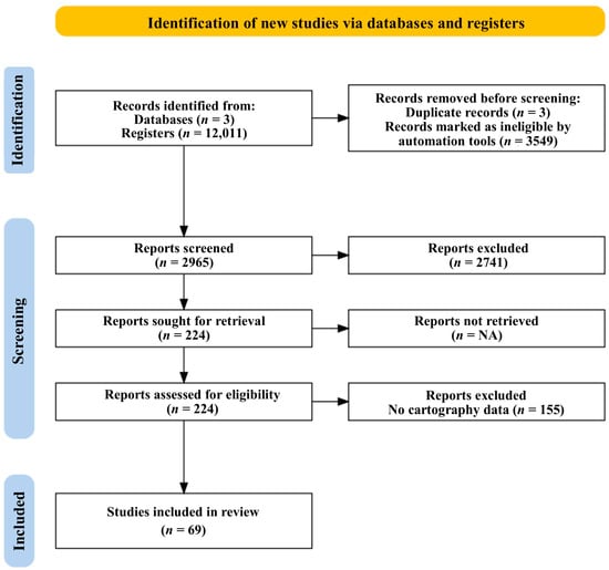
Figure 3.
PRISMA flow diagram that shows the bibliography search process (created with Ryyan app [129]).
2.5. Data Extraction and Coding
The information from each article was first consolidated into an Excel template, creating two separate databases (Table 2): one for studies and another for species observations. The first database compiled methodological and contextual features, including mapping techniques, study area, research period, and other relevant factors. The second database focuses on taxonomic details, tracking the species recorded, the number of studies in which they appeared, and their presence or absence in each archipelago.
Table 2.
Summary of data sources extracted from the literature review.
2.6. Methodological Quality Assessment and Data Analysis
Methodological quality was assessed using an ad hoc strategy that evaluated the clarity of the technique descriptions, transparency in identifying limitations, and the relevance of the methodologies employed. Three of the authors conducted the literature review, resolving any discrepancies through consensus [105].
The data analysis incorporates qualitative descriptions and graphical representations to evaluate the temporal distribution and application of mapping techniques. Statistical tools, such as SPSS v. 2.17c [130] and PAST v. 29.0.1 [131], were used for descriptive analyses and to assess correlations between different variables. Additionally, methods and patterns of habitat representation were examined to identify optimal combinations for mapping complex ecosystems. Studies with a high risk of bias (e.g., grey literature, non-peer-reviewed studies) were excluded to enhance the validity of the conclusions. In the graphical and tabular summaries, individual publications may be represented multiple times, as a single article can report multiple mapping methodologies and/or assess multiple habitat types across archipelagos. Consequently, cumulative frequencies and percentage distributions in the figures do not sum to 100%, reflecting the overlapping nature of methodological and habitat classifications rather than data omission.
3. Results
3.1. Research Effort and Objectives
From a total of 12,011 articles identified across three databases, the initial screening narrowed the sample to 2965, of which 224 were analyzed in detail. The review focused on 69 studies, providing key insights into the mapping of marine ecosystem engineers in the concerned archipelagos. Additionally, data on 506 species were collected and compiled into a separate database as part of the taxonomic analysis derived from the reviewed articles.
Geographical and temporal patterns revealed that 30 studies were recorded in the Canary Islands, 29 in the Azores, 8 in Madeira, and 3 in Cabo Verde. Research effort has exhibited temporal and spatial variations, with differences in intensity across each archipelago (Figure 4). The Azores experienced a peak in research activity between the late 1990s and early 2000s, followed by a resurgence and stabilization between 2005 and 2015, with a relative increase from 2020 onwards. In Madeira, research progressively increased starting in 2020. In the Canary Islands, research levels remained relatively constant since the early 2010s, with more intense activity peaks observed from 2020 onwards, persisting to the present day. Finally, in Cabo Verde, all recorded studies were conducted between 2023 and 2024. Regarding the study objectives, 41% (28 studies) focused on mapping, 38% (26 studies) on explorations, and 21% (15 studies) on monitoring (Table A2).
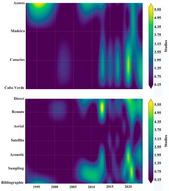
Figure 4.
Temporal changes in the number of studies by region (top) and by type of sampling method (bottom) in the context of marine research in Central-Eastern Atlantic archipelagos. The color intensity represents the density of surveys over time (1990–2025), with higher values in yellow and lower values in purple.
3.2. Methodologies and Habitats Analysis
The analyzed studies covered three main types of marine habitats: macrophyte beds, rhodolith beds, and coral reefs. Various methodologies were employed, including direct, remote, acoustic, satellite and/or aerial observation, sampling, and bibliographic review.
The methodologies have exhibit different usage patterns over time (Figure 4). Direct observation has been documented since the beginning, with higher recurrence during 2020 and 2021. Remote observation first appeared in 2000 and showed notable occurrences in 2013 and 2021. Aerial methodologies emerged in 2019, with additional occurrences in 2021 and 2024. Satellite observation first appeared in 2015 and was documented in isolated studies until 2024. Acoustics was not reported until 2012 and became more prevalent from 2020 onwards. Sampling has been used intermittently since 1992, with increased application during the 2010s. Finally, bibliographic reviews were initially recorded in the early 2000s and reappeared consistently from 2020 to 2024.
Comparative analysis among (Figure 5) and within (Figure 6) archipelagos revealed similar variations in the application of observation and data collection methodologies. In the Azores, remote observation was the predominant method, followed to a lesser extent by direct observation and sampling, with similar usage. Acoustic methods, aerial techniques, and bibliographic review were employed less frequently. In contrast, although all methodologies—except remote observation—were relatively more common in the Canary Islands, direct observation emerged as the primary method, complemented by sampling. The use of the remaining methodologies (remote observation, acoustic methods, and bibliographic review) was identical, whereas satellite observation was incorporated in a moderate and exclusive manner in the Canary Islands. In Madeira, direct observation, acoustic methods, and sampling constituted the most employed techniques, whereas remote sensing, aerial observation, and bibliographic review were applied to a lesser extent. The index of aerial observation usage was similar to that used in Canary Islands and the Azores. Finally, in Cabo Verde, the only methodologies implemented were remote observation—which proved to be the most used—followed by direct observation and acoustic methods, with equivalent usage. Bibliographic review was the only additional methodology recorded in all studies conducted in Cabo Verde.

Figure 5.
Interregional differences in terms of (top) the types of sampling methods used and (bottom) the habitats analyzed. Individual studies may be counted in multiple categories (methodologies and/or habitats), so cumulative percentages do not sum to 100%.
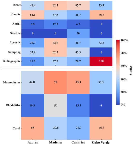
Figure 6.
Intraregional differences in (top) the types of sampling methods used and (bottom) the habitats analyzed. Individual studies may be counted in multiple categories (methodologies and/or habitats), so cumulative percentages do not sum to 100%.
3.3. Biodiversity Analysis
The greatest research effort was carried out on macroalgal beds (42 studies), followed by coral reefs (33 studies) and, to a lesser extent, by rhodolith beds (11 studies). Similarly, habitats comparisons revealed differences in the research efforts on these habitats among (Figure 5) and within (Figure 6) the archipelagos, where the Azores exhibited the higher percentage of studies related to coral reefs. Conversely, the Canary Islands focused its research efforts toward macroalgal beds, followed by the Azores and Madeira. Rhodolith beds had a similar percentage of studies across all the archipelagos, except for Cabo Verde, where no studies targeting this habitat were observed.
Our literature review recorded a total of 505 species, with the highest diversity observed in the Azores (393 species), followed by the Canary Islands (131), Madeira (69), and Cabo Verde (10) (Figure 7 and Figure 8; Table A2). The Azores concentrated the highest percentage of cnidarian species, exhibiting a similar diversity in both Hexacorallia and Octocorallia classes, accounting for ca. 86.4% of the cnidarian species observed. In particular, the Mid-Atlantic Ridge predominantly documented cnidarians (ca. 99%: Table A1). Likewise, the Azores included the greatest diversity of marine plants (Figure 8; Table A2), with the exception of Tracheophyta, which were not represented. Rhodophyta were predominant, followed by Chlorophyta and a similar percentage of Ochrophyta (Figure 8; Table A2). In the other archipelagos, a similar pattern was observed regarding cnidarians and macroalgae. However, Madeira documented a similarity in the diversity of cnidarians between Hexacorallia and Hydrozoa, presenting a lower representation of Octocorallia and a slight representation of Tracheophyta. The Canary Islands exhibited the highest diversity of Tracheophyta (Figure 8; Table A2). With respect to cnidarians in the Canary Islands, a higher percentage of Hexacorallia was observed, followed by Octocorallia and Hydrozoa. Finally, in Cabo Verde, the diversity was concentrated in cnidarians, with a greater diversity of Octocorallia than of Hexacorallia, and no macroalgae were documented, except for Tracheophyta (Figure 8; Table A2).
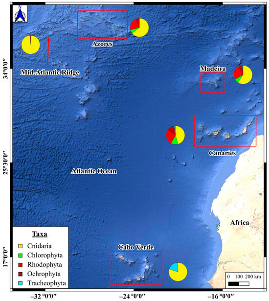
Figure 7.
Spatial distribution of the study regions in Central-Eastern Atlantic archipelagos and the Mid-Atlantic Ridge, with proportional representation of the main taxonomic categories registered in each region.
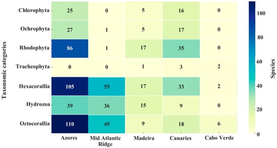
Figure 8.
Species richness by taxonomic category and region in the Central-Eastern Atlantic archipelagos and the Mid-Atlantic Ridge. The matrix shows the number of species recorded per group.
Regarding singular species (Table A3), it was evidenced that the greatest research effort was focused on seagrass meadows, specifically on Cymodocea nodosa (Ucria) Ascherson, 1870, which was the subject of 14 studies. Subsequently, the effort was directed toward brown macroalgae, in particular Dictyota spp. (J.V. Lamouroux, 1809) and Padina pavonica (Linnaeus, Thivy, 1960), which were the subject of 12 and 10 studies, respectively. Among corals, the species that were studied most intensively were the octocoral Viminella flagellum (Johnson, 1863) and two hexacorals, Desmophyllum pertusum (Linnaeus, 1758) and Antipathella wollastoni (Gray, 1857), each appearing in 8 studies.
Methodological approaches to studying marine benthic communities varied according to habitat and region (Figure 9). Throughout the geographical range considered, macroalgae were studied mainly by direct observation and sampling, while remote sensing and acoustic methods were used less frequently. In rhodolith beds, direct observation (seven cases) and acoustic methods (five cases) were the most common approaches. Corals, which were found at depths of up to 4000 m, were investigated primarily by remote sensing (25 cases) and acoustic methods (13 cases), although sampling and direct observation were also applied. Acoustic methodologies, in particular, were used more frequently in the Canary Islands (eight cases) and the Azores (six cases). Overall, the Azores and the Canary Islands represented the majority of the studies, demonstrating a diverse methodological approach.
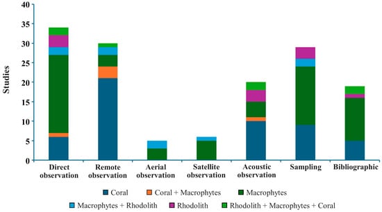
Figure 9.
Number of studies by type of sampling method, broken down according to the combination of areas and habitats analyzed.
3.4. Postprocessing Data Analyses
Of the total studies analyzed, 62% incorporated some form of mapping, with 25% generating geological cartography. The remaining studies provided cartographic data as coverage or visual percentages, supplementing spatial analyses. Computational modeling appeared in ca. 49% of the studies, showing a ca. 750% increase between 2010 and 2020, followed by an additional 100% rise between 2020 and 2024 (Table A2).
This growth coincided with the integration of geographic information systems (GIS), described in ca. 47% of the studies, combined often with image analysis tools (18 studies) or remote sensing data (15 studies). GIS was primarily used to predict coral and macrophyte beds distributions based on remote, acoustic, and direct observation data (Figure 10).
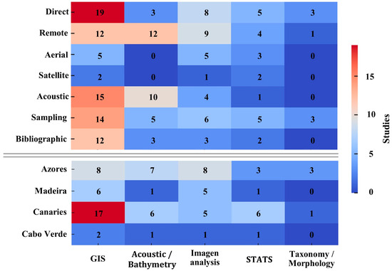
Figure 10.
List of post-processing analyses, including geographic information systems (GIS), acoustic data analysis, image analysis, statistical analysis (STATS), and taxonomic/morphological analysis, with (top) the types of sampling methods used and (bottom) the archipelagos analyzed.
The Azores and Canary Islands showed a strong preference for GIS, while Madeira relied more on taxonomic and morphological tools. Rhodolith beds were linked to GIS and acoustic/bathymetric analysis, macrophytes to GIS and statistical analysis, and corals to GIS and image analysis (Figure 10).
4. Discussion
Although marine research in some of the Central-Eastern Atlantic archipelagos dates back to the 19th century, these studies have predominantly focused on taxonomy and species cataloguing, relegating habitat mapping to a secondary position [132]. During the last 30 years, research efforts have been concentrated, particularly in the Azores and the Canary Islands archipelagos, while in Cabo Verde, such efforts are scarce or nearly non-existent (Figure 11).
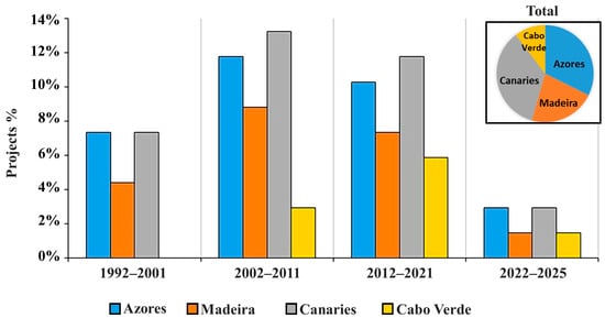
Figure 11.
Percentage of European-funded projects by Archipelago. Sources accessed on 5 March 2025: https://cinea.ec.europa.eu/programmes/life_en; https://cordis.europa.eu/; https://interreg.eu/; https://fundacion-biodiversidad.es/; https://www.biodiversa.eu/; https://plocan.eu/; https://www.mac-interreg.org/.
Transnational cooperation projects focus on the monitoring, conservation, cataloguing, and mapping of marine biotopes dominated by habitat-forming megafauna, considered vulnerable marine ecosystems (VMEs), through projects such as MISTICSEAS, MIMAR, POPCORN, and MOVE ON (https:misticseas3.com/es; https:www.mare-centre.pt/en/proj/mimar; https://www.ecoaqua.eu/en/habitats-popcorn.html; https://www.moveon-project.eu/homepage/) (accessed on 3 July 2025). However, updated information on the current progress in comprehensive seabed mapping remains limited. An example is the situation observed in the studies conducted on the Mid-Atlantic Ridge, where extensive knowledge from multiple multinational expeditions since 1954 remains unpublished in indexed scientific journals, existing mainly as technical reports or grey literature [133,134].
4.1. Methodologies and Technological Advances
4.1.1. Direct and Remote Observation Techniques
Direct observation is essential for producing highly detailed and accurate thematic maps based on biota distribution, usually complemented by in situ sampling, thereby facilitating the identification of spatial patterns and ecological processes. While this methodology achieves the highest level of accuracy, its effectiveness is inversely related to its spatial coverage [111,113,135,136,137] (Figure 1; Table A1).
Although direct observation of keystone species and habitats has been systematically employed over time, it is now complemented by emerging remote technologies, such as optical remote observation, or its combination with acoustic and satellite methods, enabling three-dimensional analysis (horizontal and vertical dimensions) [111,138,139]. Currently, marine habitats can be effectively mapped using various stationery and mobile cameras, including remotely operated vehicles (ROVs) and autonomous underwater vehicles (AUVs), providing high-resolution imagery for species identification with expert analysis [140,141]. These tools can explore challenging areas, enabling long-term monitoring and broad data collection [142,143,144,145] (Figure 1; Table A1). However, they face limitations in covering very extensive areas and dealing with the “canopy effect,” which obscures deeper layers, necessitating complementary mapping methods [137,146]. Specifically, in the Canary Islands, camera-based methods—either standalone or combined with other methods—have proven particularly effective for subtidal habitats and deep-water ecological studies, more so than for intertidal zones [137,147]. Furthermore, this approach aligns well with other methodologies, such as the MNCR biotope method employed in the Azores, facilitating the identification and monitoring of structural changes within algal communities [148].
4.1.2. Acoustic Methodologies
Technological advancements have transformed the way information is acquired and interpreted [149,150]. The development of acoustic technology in the 1940s revolutionized seabed exploration, enabling the interpretation of seabed textures over extensive areas and the creation of more realistic images [151,152]. Over time, technological improvements have significantly enhanced data acquisition and image resolution by refining acoustic signal properties and advancing digital tools for acoustic data analysis [152,153]. Among the various acoustic systems, wide-beam or multibeam systems (side-scan sonar or SSS) [151,152,154], single-beam echo sounders or fish-finders [152,155], and multibeam echosounder systems (MBES) [152,156] are widely utilized. Within the concerned oceanic archipelagos, this review highlighted SSS and MBES as the most versatile acoustic technologies employed by regional marine research, particularly for habitat characterization along the Mid-Atlantic Ridge [14,61,157,158] (Figure 1; Table A1).
Our review suggests that SSS was particularly effective in identifying substrate textures and highly efficient in habitats with sedimentary and rocky bottoms, as well as in detecting coral reefs and seagrass beds in the Azores and Canary Islands [14,158,159]. Conversely, MBES was more precise in measuring bathymetry and seabed relief, making it more suitable for characterizing deep-water habitats, such as coral reefs along the Mid-Atlantic Ridge [61,160,161,162]. Furthermore, advancements in MBES post-processing have facilitated the implementation of new multi-detection (MD) techniques capable of estimating the presence of CWC gardens in the Azores and Canary Islands (e.g., black corals [52,61,163], undetectable directly via SSS or MBES due to their proteinaceous composition. Such techniques lay the groundwork for enhancing future distribution maps of other key habitats [163].
4.1.3. Aerial and Satellite Methodologies
Aerial remote sensing is transforming marine mapping by providing high-resolution data on habitat coverage and coastal morphological changes using optical, thermal, and hyperspectral sensors [164]. Its capacity for operating at high spatial resolution makes it ideal for monitoring coastal ecosystems and intertidal zones, facilitating vegetation cover analysis [4,164,165,166,167]. Aerial platforms equipped with LiDAR (light detection and ranging) enable precise bathymetric mapping in shallow waters [111], generating detailed digital models of sandy bottoms and reefs [4,165,166,167,168] (Figure 1; Table A1). Specifically, in the Azores, Madeira, and the Canary Islands, drones (unmanned aircraft systems or UAS) have effectively monitored shallow waters and algal blooms; however, highly heterogeneous habitats present methodological challenges due to environmental and meteorological variables limiting their spatio-temporal applicability [166,167,168]. Additionally, they cannot accurately differentiate benthic communities without ground-truthing support [166,167] (Figure 1; Table A1). To overcome these limitations, Monteiro et al. [166] proposes an integrated approach, by combining in situ data—specific benthic composition—with physiographic mapping derived from UAS imagery.
Satellite platforms (Sentinel, Landsat, and WorldView) employ multispectral and hyperspectral sensors, enabling the large-scale monitoring of shallow marine ecosystems [169,170,171,172,173,174,175]. They offer extensive temporal and spatial coverage, providing characterizable images alongside abiotic and oceanographic variables such as temperature, pH, or chlorophyll [164,176,177,178,179,180,181,182]. Despite their effectiveness in marine habitat mapping, satellite studies have been conducted almost exclusively in the Canary Islands, frequently adopting a single-methodological approach and facing limitations due to reliance on reflectance and/or spectral profiles without integrating in situ biological data [166,181] (Figure 1; Table A1). For example, multitemporal satellite image analysis was applied to evaluate the impact of the Granadilla port construction on the special conservation area (SAC) of “Sebadales del Sur” in Tenerife (Canary Islands) [183]. Cosme De Esteban et al. [2] underscored the importance of ground truthing regarding satellite approach, as, for example, comparisons carried out in Príncipe Island (Gulf of Guinea) that revealed discrepancies in delineating marine habitats of high ecological value, such as rhodolith beds, where the acoustic methodology supported by direct observations was more precise compared to satellite methods. Furthermore, Eugenio et al. [177] highlights the efficacy of these multitemporal approaches integrating bathymetric and benthic studies to detect variations through qualitative and quantitative analysis, producing high-resolution maps.
Globally, aerial methods provide higher spatial resolution and greater flexibility for selecting optimal environmental conditions, whereas satellite imagery analysis reduces exploratory sampling needs, improving efficiency in time and cost and reducing sampling bias [166,167,168]. Despite proven efficacy, aerial and satellite remote sensing methodologies remain underrepresented, predominantly applied in the Canary Islands and the Azores, where usage has increased since 2021 (Figure 1; Table A1). In the Canary Islands, image processing and automatic classification algorithms based on artificial intelligence and deep learning have achieved up to ca. 96% effectiveness in discriminating species, such as the genera Cymodocea and Gongolaria [168], highlighting the increased analytical precision made possible by these advancements; however, clearly defined training areas and ground-truthing validation remain essential [177,181,184].
4.1.4. Data Postprocessing
Once cartographic data are collected, integrating them into a unified reference framework becomes essential. This integration is facilitated by geographic information systems (GIS), which aid in spatial organization and analysis [185,186,187]. GIS effectively consolidate datasets that differ in spatial, temporal, and thematic scales, thereby addressing informational heterogeneity [188,189]. The literature demonstrates extensive use of specialized software for image analysis [132,137] and GIS programs (e.g., ESRI’s ArcGIS or QGIS) for the integration of georeferenced vector and raster data [4,133,165,190]. Additionally, analytical interfaces have been optimized through additional tools that facilitate visualization and map overlays, allowing the combination of habitat information and physicochemical variables. Such integration is pivotal for conducting statistical analyses and creating predictive maps through modeling [158,159].
Following database integration, habitat mapping advances by modeling habitat conditions, emphasizing the biological integrity index and anthropogenic stress factors [87,191].
Identifying new biotopes and extensive data collection on taxonomic diversity significantly enhance predictive statistical modeling at multiple spatial scales [192,193]. This modeling facilitates an integrated assessment of biodiversity and generates predictive maps incorporating anthropogenic risks and impacts [194,195,196,197]. According to Braga-Henriques et al. [193], accurate modeling and data analysis require standardized data formats. However, heterogenous data collection from different periods, campaigns, and multinational organizations complicates direct standardization, requiring the use of probability mapping or prior data refinement according to established standards [132]. Refinement involves standardizing classifications and terminologies to ensure coherent mapping and effective environmental data storage [132]. Consequently, the hierarchical EUNIS habitat classification system, extensively applied across Europe, can support large-scale habitat mapping by integrating comprehensive ecological knowledge and spatial data on seabed characteristics [183]. Accordingly, in the Canary Islands, a study provided the first comprehensive spatial assessment of benthic ecosystem service supply (until 50 m depth; [198]), generating maps through a flexible, updatable methodological approach based on the scientific literature, directly applicable to marine spatial planning.
One of the initial steps in Mapping and Assessment of Ecosystems and their Services (MAES) involves ecological niche and food web characterization using specialized models and software (e.g., ECOPATH, ECOSIM, ENFA, or MAXENT). These tools are crucial for analyzing energy flows and predicting species distribution changes due to environmental disturbances and anthropogenic activities [111,164]. Their application has been pivotal in predictive analyses of species distribution, such as CWC, in studies conducted in the Azores and Cabo Verde [193,199]. When information is limited or historically incomplete, implementing ensemble models has proven effective. In Cabo Verde and the Canary Islands, combining these models with AI and deep learning classification techniques (i) predicted new CWC presence areas on seamounts [199], (ii) identified the potential distribution of algae (both essential and invasive), and (iii) assessed seagrass meadow conditions following port infrastructure construction [147,200]. In the Azores, integrating data on anthropogenic activities (e.g., fisheries) and protected areas has facilitated evaluations of interactions between key habitats, such as macroalgae and CWC, and resources [146,159,193]. This information provides critical insights into ecosystem functioning, niche interactions, and influencing variables, contributing to the development of distribution maps that inform the spatial planning and conservation strategies of these essential habitats [4,159,179,193]. Finally, in the Canary Islands, visual analyses and the first ecological model of an MPA have demonstrated the potential of this conservation tool and the responses of communities to natural events [179,201], thereby facilitating adjustments in MPA design and management policies. Collectively, these data support improvements in design and management policies to ensure the conservation and recovery of ecosystems [4,179,201].
4.2. Habitat Mapping
Marine habitat maps are developed using a variety of methodologies that integrate multiple sources of data (see Section 4.1). Biological data (e.g., species and community distributions), geophysical variables (e.g., bathymetry, geomorphology, physicochemical parameters), and habitat-related factors (e.g., ecosystem services and local and global threats) collectively determine the precision, spatial coverage, quality, and overall utility of the final habitat map.
4.2.1. Methodologies
Marine habitat mapping remains operationally challenging and costly despite technological advancements since the late 1990s, which have enhanced spatial coverage and data accuracy [132,202]. While studies often rely on either direct imaging or remote observation methods individually [166,203], integrating multiple methodologies significantly enhance accuracy by offsetting each technique’s inherent limitations [137]. For instance, in the Canary Islands and Azores, studies relying exclusively on remote sensing techniques effectively describe facies and community structure. However, these approaches can be limited by the “canopy effect”, where dense algae cover or CWC gardens may obscure underlying strata, hindering the observation of all present taxa [137]. Furthermore, while all benthic environments provide characterizable data, some habitats inherently yield more detailed or relevant information due to their specific ecological and structural properties. Thus, the potential for comprehensive habitat mapping varies depending on the nature of the seafloor being studied. Therefore, it is essential to clearly define the types of thematic maps that can be generated from such data [32,161]. No single approach exists for their development, given the multidisciplinary complexity and the variability associated with the specific objectives of each project. Consequently, multidisciplinary campaigns are conducted—such as the one carried out in the Azores by Somoza et al. (2020) [161]—in which both biological and abiotic data (e.g., geophysical, hydrographic, geological, oceanographic, etc.) were collected, enabling the description of new hard and soft coral gardens and the analysis of the factors that determined their location and distribution.
4.2.2. Biotic–Abiotic Data
Marine habitat maps integrate multiple data sources, including biological (e.g., species and community distributions) and geophysical variables (e.g., bathymetry, geomorphology, and physicochemical parameters). According to Brown et al. [186], habitat maps can be classified based on mapped variables, distinguishing between biological and abiotic data [51,204,205]. Adopting a hierarchical, multiscale approach at species, community, and ecoregion levels enhances maps comprehensiveness [140,206,207]. Additionally, discovering new biotopes and detecting structural or distributional changes through repeat mapping or predictive modeling improve habitat-classification accuracy [166,179,184,200]. However, maps focused solely on geophysical features remain incomplete without integrating biological information [186,208,209,210]. In these volcanic archipelagos, geological studies commonly regard biological analyses as secondary, especially in deep-water habitats such as the Mid-Atlantic Ridge and hydrothermal areas of the Azores [158,160,202,211]. Since 2013, however, multidisciplinary research—particularly in the Azores and the Canary Islands—has significantly expanded, driven by technological innovations, advanced methodologies, integrated management plans, and improved infrastructure and funding availability (Figure 11; [195]).
Other mapping investigations treat spatial information as complementary or secondary to the primary objective, which is to collect biotic or abiotic data from marine habitats or facies. For example, research on hydrothermal habitats, in metal-rich areas—such as those hosting Rimicaris shrimp populations along the Mid-Atlantic Ridge (Azores)—enable the generation of more accurate predictive models for species distributions [203]. Conversely, investigations that specifically map and characterize valuable habitats, such as the seagrass meadows of C. nodosa in the Canary Islands, facilitate the prediction of dynamics in related communities, including fishery populations [181,212].
4.2.3. Habitat-Related Factors
Marine habitats are increasingly threatened by global and local threats (e.g., climate change, overfishing, pollution, and coastal development), underscoring the need for up-to-date habitat mapping to manage these ecosystems effectively [166]. In the concerned oceanic archipelagos, several studies have already used direct and remote-sensing techniques to detect and map local threats (e.g., marine litter, trawling, long line fisheries, etc.), showing how cumulative stressors erode functional diversity and community structure over time, particularly in morphologically complex taxa such as CWC [153,157,202,213]. Additionally, marine litter data have been used in advanced predictive modeling to pinpoint plastic accumulation hotspots and compare them with potential key habitat areas [214]. Documenting spatial links between habitats and both historical and contemporary local threats is, therefore, essential for evidence-based conservation and management [134,147,165,181]. Thus, Martín-García et al. [147] established cause and effect relationships between human and environmental drivers that influence the distribution of brown macroalgae (e.g., Gongolaria abies-marina) in the western Canary waters. Equally, studies performed in Cabo Verde on abiotic factors (e.g., topography and hydrodynamics) are essential for characterizing habitats and supporting predictive models. This approach has effectively identified food supply mechanisms for suspension feeders and potential areas for key species such as the coral Enallopsammia rostrata [201].
Understanding how the distribution and persistence of key habitats have changed in response to local threats is also critical for contextualizing recent observations. In Madeira, a southward regression of Laminaria ochroleuca has been documented [157], along with a decline in several Sargassaceae species [147]. Nonetheless, high resolution imagery of adult L. ochroleuca specimens (ca. 5–7 years) suggests that the archipelago may serve as a climate refuge against ocean warming [157]. Meanwhile, the first exhaustive mapping of rhodolith beds in Madeira revealed a widespread distribution across the archipelago, extending to depths of ~100 m—considerably deeper than typically reported in the northeastern Atlantic and comparable to the Azores [192]. Finally, regarding seagrass beds, Cymodocea nodosa and Avrainvillea canariensis patches have decreased in southern areas within a marine protected area (Parque Natural Marino de Cabo Girão) [132,190,215]. In the Azores, regressions have also been observed in several species of the Sargassaceae family [147]. However, while the mesophotic niche occupied by algae in the Azores benefits from some protection against natural and anthropogenic stressors, it remains vulnerable to climate change, with predictions indicating a decrease of between 23% and 85% in the thermal niche of L. ochroleuca by 2100 [216]. Finally, in the Canary Islands, intensified maritime traffic favors invasive species introduction, notably, populations of scleractinian corals (Savalia savaglia, Tubastraea sp., Oculina sp., and Culicia sp.), necessitating continuous monitoring of these species [153,217]. The brown macroalgae forest of Gongolaria abies-marina transitioned from extensive to fragmented forests in the upper sublittoral zone, almost disappearing in areas such as the Canary Islands [147,165,168]. This coincides temporally with the increase in marine heatwaves (MHW), which displace species toward cooler waters [218], and with increased coastal urbanization. These activities can also negatively impact seagrass seabeds, causing the reduction or disappearance of C. nodosa meadows and rhodolith beds, which are frequently replaced by invasive species (Caulerpa racemosa, Caulerpa prolifera) accompanied by cyanobacterial proliferations (Lyngbya spp.) [180,212,213,219].
4.2.4. Final Habitat Map in the Central-Eastern Atlantic Archipelagos
Most conservation projects are undertaken within MPAs, whose design has progressively shifted—driven by technological advances and the adoption of ecosystem-based policies—from a focus on single emblematic species to an integrated view of ecosystem functioning. Consistent, high resolution habitat mapping is, therefore, indispensable for redefining existing MPAs, proposing new ones, and ensuring comparability at the regional scale [2,61,157,220]. For example, Cosme De Esteban et al. [61] recommended revising an Azorean MPA originally delimited to protect a seabird colony; the absence of a marine component resulted in a buffer zone dominated by sedimentary substrates and excluded reef habitats characterized by cold water corals. Likewise, cartographic and taxonomic surveys along the Mid Atlantic Ridge—sites initially designated as Natura 2000 Sites of Community Importance for cetacean conservation—have revealed extensive mesophotic and deep-water habitats of high ecological value, warranting an expansion of the protection boundaries [157].
4.3. Challenges and Future Implications
Globally, the review of the current status of marine habitat mapping in the oceanic and volcanic archipelagos highlighted two fundamental and interdependent methodological stages: exploration and monitoring. The exploratory stage aims to address initial questions about habitat presence, distribution, and ecological importance, laying the groundwork for subsequent, detailed studies. Clear examples from the Azores and the Canary Islands demonstrate how initial exploration identified essential habitats, such as cold-water coral gardens and rhodolith beds, which might otherwise have been overlooked in marine protected area planning. Conversely, the monitoring stage assesses temporal habitat changes and evaluates the effectiveness of implemented conservation measures, as exemplified in the Azores, Madeira, and the Canary Islands, where inadequate monitoring has limited effective management of key habitats.
A comprehensive analysis of methodologies and outcomes revealed significant progress in advanced technological applications, particularly in the Azores and Canary Islands, where a wide array of sophisticated tools—such as remote sensing, acoustic, and satellite sensors (e.g., side-scan sonar, MBES)—have been successfully implemented. However, this contrasts sharply with Madeira and, especially, Cabo Verde, archipelagos constrained by limited technological infrastructure and marine research funding. This regional disparity directly impacts the quality and comprehensiveness of the bionomic maps produced, hindering the necessary interregional comparisons and integrations required for effective integrated management. To address this, regional initiatives promoting technological cooperation and specialized training of local researchers are crucial, as partially achieved by the Azores and Canary Islands through European-funded programs.
Furthermore, integrating and standardizing data generated from diverse methodological techniques remained a significant challenge. The involvement of various stakeholders employing different methodologies resulted in heterogeneous databases, complicating their coherent integration into thematic maps. Studies conducted in the different archipelagos, notably in the Azores, emphasized the imperative need for standardized reference frameworks, systematic field validation (ground truthing), and robust data validation protocols. Adopting these measures will enhance data reliability and accuracy, thereby strengthening the predictive modeling capabilities essential for effective marine ecosystem management.
Advanced techniques such as computational modeling, GIS systems, and artificial intelligence have also revolutionized marine mapping in the region. Nevertheless, these technological innovations introduced specific challenges related to processing, analyzing, and interpreting large volumes of data, especially in contexts with limited technological infrastructure. In areas such as Cabo Verde, where technological adoption remains constrained, it is essential to strengthen analytical capabilities and provide specialized training in spatial data processing. Such improvements are crucial for accurate data interpretation and scientifically informed decision-making.
The effective and sustainable management of marine habitats in the Central-Eastern Atlantic archipelagos requires an integrated approach that combines biological and geophysical data to produce detailed bionomic maps. In the Azores, the initial lack of such integration resulted in the exclusion of keystone habitats, including CWC, from established MPAs. Therefore, regular updates and the continuous refinement of habitat maps, supported by GIS tools and predictive modeling, are essential for accurate ecological assessments of anthropogenic pressures, ensuring the effectiveness of ecosystem-based conservation strategies.
At present time, stronger scientific cooperation regarding marine habitat mapping will foster more effective decision-making processes in the framework of evolving marine spatial planning activities, where the marine conservation sector, usually, is not very represented and deserves a more intense focus.
In conclusion, overcoming the challenges identified in this review requires coordinated efforts integrating methodological standardization, investment in advanced technologies, and robust interregional collaboration. The successful implementation of these strategies will substantially enhance the precision of marine habitat mapping in the region, providing a solid foundation for the effective management and conservation of marine ecosystems in face of current and future environmental and anthropogenic pressures. Importantly, the methodological advances, lessons learned, and recommendations highlighted here are directly applicable to the global design, management, and monitoring of MPAs, and can inform the implementation of international frameworks such as the Biodiversity Beyond National Jurisdiction (BBNJ) Agreement. This regional review, thus, offers practical guidance for enhancing marine habitat mapping and supporting evidence-based conservation in oceanic and deep-sea environments worldwide.
Supplementary Materials
The following supporting information can be downloaded at: https://www.mdpi.com/article/10.3390/rs17132331/s1, Formula: Searching Formula (TITLE-ABS-KEY if searching with SCOPUS; and TS = if searching with Web of Science).
Author Contributions
M.C.D.E.: Writing—review and editing, Writing—original draft, Investigation, Visualization. F.T.: Writing—review and editing, Validation. R.H.: Writing—review and editing, Supervision. F.O.-F.: Writing—review and editing, Writing—original draft, Supervision, Investigation. All authors have read and agreed to the published version of the manuscript.
Funding
This work was partially supported through the European Community project 101093910—OCEAN CITIZEN, grant agreement ID: 101093910, https://cordis.europa.eu/project/id/101093910. Work co-financed by the Canarian Agency for Research. Innovation and Information Society of the Ministry of Economy. Knowledge and Employment and by the European Social Fund (ESF) Integrated Operational Programme of the Canary Islands 2014–2020. Axis 3 Priority Theme 74 (85%).
Data Availability Statement
The original contributions presented in this study are included in the article/Supplementary Materials. Further inquiries can be directed to the corresponding author(s).
Conflicts of Interest
The authors declare no conflicts of interest. The funders had no role in the design of the study; in the collection, analysis, or interpretation of data; in the writing of the manuscript; or in the decision to publish the results. The authors declare the following financial interests/personal relationships which may be considered as potential competing interests: Marcial Cosme De Esteban reports financial support was provided by Canarian Agency for Research Innovation and Information Society.
Appendix A
Table A1.
Summary of key performance variables associated with each habitat mapping methodology, including general limitations and relative levels of precision across the three main habitat types assessed in this study: macroalgal beds, rhodolith beds, and coral reefs. Each variable is represented according to its relative level (high, medium, or low), using both an arrow (upward, horizontal, or downward orientation) and a color scale (green, yellow, and red, respectively).
| Coverage | Resolution | Taxonomic Accuracy | Relative Cost | Relative Depths | Limitations | Habitats | |||
|---|---|---|---|---|---|---|---|---|---|
| Macrophytes | Rhodolith Beds | Coral | |||||||
| Direct observation and Sampling | 🡻Low | 🡹High | 🡹High | Medium-🡾Low | Shallow |
| 🡹High | 🡹High | 🡹High |
| Direct identification analysis of species, structure, and habitat health status. | Direct identification analysis of species, structure, and habitat health status. | Direct identification analysis of species, structure, and habitat health status. | |||||||
| Remote observation | 🡺Medium | 🡹High | 🡹High | Medium-🡽High | Deep |
| 🡹High | 🡹High | 🡹High |
| Direct identification analysis of species, structure, and habitat health status. Limitation for cryptic or small species. | Direct identification analysis of species, structure, and habitat health status. Limitation for cryptic or small species. | Direct identification analysis of species, structure, and habitat health status. Limitation for cryptic or small species. | |||||||
| Aerial observation | 🡺Medium | Medium-🡽High | 🡺Medium | Medium-🡾Low | Shallow |
| 🡺Medium | 🡻Low | 🡺Medium |
| Distinguishes extensive meadows and algal patches, without reaching species level. | Difficult to identify rhodolith structures from the air due to confusion with other substrates. | General differentiation of reefs and coral patches in shallow and clear water. No taxonomic precision. | |||||||
| Satellite observation | Very 🡹🡹High | 🡺Medium | 🡻Low | Medium-🡾Low | Shallow |
| 🡺Medium | 🡻Low | 🡺Medium |
| Broad differentiation of submerged vegetation cover, limited to general classes. | Difficult to identify rhodoliths due to spectral and spatial limitation. | Useful for mapping shallow reef tracts. No taxonomic precision. | |||||||
| Acoustic observation | 🡹High | 🡹High | 🡻Low | 🡹High | Deep |
| 🡻Low | 🡺Medium | 🡻Low |
| Detects bottom texture, possible identification of dense coverages, but without precision. | Recognizes rough structures associated with rhodoliths, requires in situ validation. | Identification of relief and reef structures. No biological detail. | |||||||
Table A2.
Table of variables analyzed from the reviewed articles.
Table A2.
Table of variables analyzed from the reviewed articles.
| Habitats | |||||||||||||||
|---|---|---|---|---|---|---|---|---|---|---|---|---|---|---|---|
| Paper | Reference | Year | Zone | Main Objective | Macrophytes | Rhodolith Beds | Coral | Habitat Map | Geological Map | Depth (m) | Substrate | Area Size (ha) | |||
| 1 | [192] | 2021 | Madeira | exploratory | - | x | - | x | - | 35 | mixed | 2.368 | |||
| 2 | [215] | 2022 | Madeira | monitoring | x | - | - | x | - | 20 | soft | - | |||
| 3 | [148] | 2000 | Azores | monitoring | x | - | - | - | - | 40 | hard | - | |||
| 4 | [203] | 2000 | Azores | exploratory | - | - | x | - | - | 3800 | hard | - | |||
| 5 | [220] | 2008 | Azores | monitoring | x | - | - | x | - | 30 | hard | 400 | |||
| 6 | [153] | 2015 | Canary Islands | exploratory | - | - | x | - | - | 600 | hard | - | |||
| 7 | [157] | 2022 | Madeira | exploratory | x | x | x | - | - | 990 | mixed | 1.55 | |||
| 8 | [182] | 2017 | Canary Islands | mapping | x | - | - | x | - | 20 | mixed | - | |||
| 9 | [175] | 2022 | Azores | exploratory | - | - | x | - | - | 210 | mixed | 0.019 | |||
| 10 | [183] | 2015 | Azores | mapping | x | x | x | x | - | n/a | mixed | 167,692.2 | |||
| 11 | [163] | 2023 | Canary Islands | mapping | - | - | x | x | - | 110 | mixed | 48.075 | |||
| 12 | [134] | 2012 | Azores | exploratory | - | - | x | - | - | 3,3 | mixed | - | |||
| 13 | [146] | 2017 | Azores, Canary Islands | exploratory | x | - | x | - | - | 734 | mixed | - | |||
| 14 | [221] | 1992 | Azores | exploratory | x | - | - | x | - | 5,5 | hard | - | |||
| 15 | [202] | 2013 | Madeira | mapping | - | - | x | x | x | 2660 | soft | 56,000 | |||
| 16 | [160] | 2020 | Azores | exploratory | - | - | x | - | x | 1700 | hard | 0.045 | |||
| 17 | [213] | 2014 | Canary Islands | monitoring | x | - | - | - | - | 15 | soft | 393.9 | |||
| 18 | [212] | 2014 | Azores | monitoring | - | - | x | - | x | 1092 | hard | - | |||
| 19 | [222] | 2021 | Azores | exploratory | - | - | x | - | x | 595 | hard | - | |||
| 20 | [223] | 2013 | Azores | exploratory | - | - | x | - | x | 1097 | mixed | 2.378 | |||
| 21 | [193] | 2013 | Azores | exploratory | - | - | x | x | - | 1500 | hard | - | |||
| 22 | [15] | 2019 | Canary Islands | monitoring | - | x | - | x | - | 50 | mixed | 0.72 | |||
| 23 | [181] | 2021 | Canary Islands | monitoring | x | - | - | - | - | 75 | soft | - | |||
| 24 | [14] | 2020 | Canary Islands | monitoring | - | x | - | - | - | 40 | soft | - | |||
| 25 | [180] | 2024 | Canary Islands | monitoring | x | x | - | x | - | 25 | mixed | 2150 | |||
| 26 | [199] | 2024 | Cabo Verde | mapping | - | - | x | x | x | 2100 | hard | 118,800 | |||
| 27 | [147] | 2022 | Canary Islands | monitoring | x | - | - | - | - | n/a | hard | - | |||
| 28 | [132] | 2020 | Madeira | mapping | x | x | x | x | - | 50 | mixed | 240 | |||
| 29 | [61] | 2024 | Azores | mapping | x | - | x | x | - | 60 | mixed | 394.08 | |||
| 30 | [224] | 2018 | Canary Islands | mapping | x | - | - | x | - | 50 | mixed | 9138 | |||
| 31 | [219] | 2013 | Canary Islands | exploratory | x | - | - | - | - | 19 | mixed | - | |||
| 32 | [225] | 2019 | Madeira | exploratory | x | - | - | - | - | 2,6 | mixed | - | |||
| 33 | [226] | 2006 | Azores | exploratory | x | - | - | x | - | 20 | hard | - | |||
| 34 | [217] | 2019 | Canary Islands | exploratory | - | - | x | x | - | 35 | hard | 0.018 | |||
| 35 | [165] | 2024 | Canary Islands | monitoring | x | - | - | x | - | 50 | hard | - | |||
| 36 | [190] | 2021 | Madeira | monitoring | x | - | - | - | - | 12 | soft | 0.009 | |||
| 37 | [4] | 2021 | Azores | mapping | x | - | - | x | - | 15 | mixed | - | |||
| 38 | [227] | 2012 | Canary Islands | exploratory | x | - | - | - | - | 46 | mixed | - | |||
| 39 | [228] | 2002 | Canary Islands | mapping | x | - | - | x | - | 10 | mixed | - | |||
| 40 | [229] | 2023 | Canary Islands | mapping | x | - | - | x | - | n/a | soft | - | |||
| 41 | [230] | 2012 | Azores | mapping | - | - | x | - | x | 1350 | hard | - | |||
| 42 | [231] | 2017 | Canary Islands | monitoring | x | - | - | x | - | 20 | hard | 7.4 | |||
| 43 | [232] | 2020 | Canary Islands | mapping | x | - | - | x | - | 40 | mixed | 746 | |||
| 44 | [179] | 2020 | Canary Islands | mapping | x | - | - | x | - | 40 | hard | 740 | |||
| 45 | [211] | 2016 | Canary Islands | mapping | - | - | x | - | x | 2500 | mixed | 367,388 | |||
| 46 | [161] | 2020 | Azores | exploratory | - | - | x | x | x | 4000 | mixed | - | |||
| 47 | [233] | 2008 | Azores | exploratory | - | - | x | - | x | 2977 | mixed | - | |||
| 48 | [178] | 2015 | Canary Islands | mapping | x | - | - | x | - | 25 | mixed | - | |||
| 49 | [214] | 2023 | Azores | mapping | - | - | x | x | - | 2387 | mixed | 154 | |||
| 50 | [159] | 2012 | Azores | mapping | x | - | - | x | x | 80 | mixed | 53,750 | |||
| 51 | [234] | 2023 | Azores | mapping | - | - | x | x | x | 2700 | hard | - | |||
| 52 | [216] | 2021 | Azores | exploratory | x | x | - | x | - | 85 | mixed | - | |||
| 53 | [235] | 2023 | Cabo Verde | exploratory | x | - | - | x | - | 5 | soft | 0.62 | |||
| 54 | [236] | 2023 | Azores | exploratory | - | - | x | x | - | 2000 | mixed | 2,200,000 | |||
| 55 | [237] | 2022 | Canary Islands | mapping | x | - | - | x | - | n/a | mixed | - | |||
| 56 | [238] | 2008 | Azores | monitoring | x | x | x | - | - | 30 | mixed | - | |||
| 57 | [52] | 2020 | Canary Islands | mapping | - | - | x | x | - | 173 | hard | 55 | |||
| 58 | [218] | 2021 | Canary Islands | mapping | - | - | x | x | x | 3000 | mixed | - | |||
| 59 | [158] | 2013 | Azores | mapping | - | - | x | - | x | 160 | hard | - | |||
| 60 | [200] | 2020 | Canary Islands | exploratory | x | - | - | x | - | 40 | mixed | - | |||
| 61 | [201] | 2013 | Canary Islands | mapping | x | - | x | x | - | 50 | mixed | 1574 | |||
| 62 | [167] | 2019 | Azores | monitoring | x | - | - | x | - | 10 | mixed | - | |||
| 63 | [184] | 2022 | Azores | exploratory | - | - | x | x | x | 1600 | hard | - | |||
| 64 | [133] | 2024 | Cabo Verde | exploratory | - | - | x | - | x | 3218 | mixed | 2.807 | |||
| 65 | [239] | 2013 | Canary Islands | exploratory | x | - | - | x | x | 45 | mixed | - | |||
| 66 | [177] | 2023 | Canary Islands | mapping | x | - | - | x | - | 20 | mixed | - | |||
| 67 | [168] | 2024 | Canary Islands | mapping | x | x | - | x | - | 10 | mixed | 58.5 | |||
| 68 | [166] | 2021 | Madeira | mapping | x | x | - | x | - | 14 | mixed | 10 | |||
| 69 | [137] | 2008 | Azores | mapping | x | - | - | - | - | 30 | mixed | - | |||
| Methologies | Data Classification | ||||||||||||||
| Paper | Reference | Year | Direct Observation | Remote Observation | Aerial Observation | Satellite Observation | Acoustic Observation | Sampling | Bibliographic | Modeling | GIS Tools | Acoustic/Bathymetry | Image Analysis | STATS | Taxonomic/Morphology |
| 1 | [192] | 2021 | x | - | - | - | x | x | x | - | x | - | x | - | - |
| 2 | [215] | 2022 | x | - | - | - | x | x | x | x | x | - | - | - | - |
| 3 | [148] | 2000 | - | - | - | - | - | - | x | - | - | - | - | - | - |
| 4 | [203] | 2000 | - | x | - | - | - | - | - | - | - | - | - | - | - |
| 5 | [220] | 2008 | x | - | - | - | - | x | - | - | - | - | - | - | x |
| 6 | [153] | 2015 | x | x | - | - | - | - | x | - | x | - | - | - | - |
| 7 | [157] | 2022 | - | x | - | - | x | - | - | - | - | - | x | - | - |
| 8 | [182] | 2017 | - | - | - | x | - | - | - | x | - | - | - | - | - |
| 9 | [175] | 2022 | - | x | - | - | - | - | - | - | - | - | x | - | - |
| 10 | [183] | 2015 | - | - | - | - | - | - | x | x | x | x | - | - | - |
| 11 | [163] | 2023 | x | x | - | - | x | - | - | x | x | x | - | - | - |
| 12 | [134] | 2012 | - | x | - | - | - | - | x | - | - | - | - | - | - |
| 13 | [146] | 2017 | x | x | - | - | - | - | - | - | - | - | x | - | - |
| 14 | [221] | 1992 | x | - | - | - | - | x | - | - | - | - | - | - | - |
| 15 | [202] | 2013 | - | x | - | - | x | x | - | x | x | x | - | - | - |
| 16 | [160] | 2020 | - | x | - | - | x | - | - | x | - | - | x | - | - |
| 17 | [213] | 2014 | x | - | - | - | - | x | - | x | - | - | - | - | - |
| 18 | [212] | 2014 | x | x | - | - | - | - | - | x | x | - | - | - | - |
| 19 | [222] | 2021 | - | x | - | - | - | - | - | - | - | - | - | - | - |
| 20 | [223] | 2013 | - | x | - | - | - | - | - | - | - | - | x | - | - |
| 21 | [193] | 2013 | x | x | - | - | - | x | x | - | - | - | - | - | - |
| 22 | [15] | 2019 | x | - | - | - | x | x | - | - | x | - | - | - | - |
| 23 | [181] | 2021 | - | - | - | x | - | - | x | x | x | - | - | - | - |
| 24 | [14] | 2020 | x | - | - | - | x | x | - | - | x | - | - | - | - |
| 25 | [180] | 2024 | - | - | - | x | - | - | - | x | - | - | - | x | - |
| 26 | [199] | 2024 | - | x | - | - | x | - | x | x | - | - | x | x | - |
| 27 | [147] | 2022 | x | - | - | - | - | - | x | x | x | - | - | - | - |
| 28 | [132] | 2020 | x | - | - | - | x | - | x | - | x | - | - | - | - |
| 29 | [61] | 2024 | - | x | - | - | x | - | - | - | x | x | - | - | - |
| 30 | [224] | 2018 | x | x | - | - | - | x | - | x | - | - | - | x | - |
| 31 | [219] | 2013 | x | - | - | - | - | x | - | - | - | - | - | - | x |
| 32 | [225] | 2019 | x | - | - | - | - | x | - | - | - | - | x | - | - |
| 33 | [226] | 2006 | x | - | - | - | - | x | - | - | - | - | - | x | - |
| 34 | [217] | 2019 | x | - | - | - | - | x | - | - | - | - | - | - | - |
| 35 | [165] | 2024 | - | - | x | - | - | - | x | x | x | - | x | - | - |
| 36 | [190] | 2021 | x | - | - | - | - | x | - | - | x | - | x | - | - |
| 37 | [4] | 2021 | x | - | x | - | - | x | - | x | x | - | x | x | - |
| 38 | [227] | 2012 | x | - | - | - | - | x | - | - | - | - | - | - | - |
| 39 | [228] | 2002 | - | x | - | - | - | - | - | x | - | - | x | - | - |
| 40 | [229] | 2023 | x | - | - | - | x | - | x | x | x | - | - | - | - |
| 41 | [230] | 2012 | - | - | - | - | - | x | - | - | - | - | - | - | - |
| 42 | [231] | 2017 | x | - | - | - | - | x | - | - | x | - | - | - | - |
| 43 | [232] | 2024 | - | - | - | x | - | - | x | x | - | - | - | - | - |
| 44 | [179] | 2020 | x | - | - | x | - | x | x | x | - | - | - | - | - |
| 45 | [211] | 2016 | - | x | - | - | x | x | - | x | x | x | - | - | - |
| 46 | [161] | 2020 | - | x | - | - | x | - | - | x | - | x | - | - | - |
| 47 | [233] | 2008 | - | x | - | - | - | x | - | - | - | - | - | - | x |
| 48 | [178] | 2015 | - | - | - | x | - | - | - | - | - | - | - | x | - |
| 49 | [214] | 2023 | - | x | - | - | - | - | - | x | - | x | - | - | - |
| 50 | [159] | 2012 | x | x | - | - | x | x | x | x | x | x | - | - | - |
| 51 | [234] | 2023 | - | x | - | - | x | - | - | x | - | x | - | - | - |
| 52 | [216] | 2021 | x | x | - | - | - | x | - | - | - | - | - | - | - |
| 53 | [235] | 2023 | x | - | - | - | - | - | x | - | x | - | - | - | - |
| 54 | [236] | 2023 | - | - | - | - | - | x | - | x | x | - | - | - | - |
| 55 | [237] | 2022 | - | - | - | - | - | - | x | x | - | - | - | x | - |
| 56 | [238] | 2008 | x | - | - | - | - | - | - | - | - | - | - | - | x |
| 57 | [52] | 2020 | x | - | - | - | x | x | - | - | x | x | - | - | - |
| 58 | [218] | 2021 | - | x | - | - | x | x | - | x | x | x | - | - | - |
| 59 | [158] | 2013 | - | x | - | - | x | - | - | - | x | - | - | - | - |
| 60 | [200] | 2020 | x | - | - | - | - | - | - | - | x | - | - | - | - |
| 61 | [201] | 2013 | - | x | - | - | x | - | - | x | x | x | - | x | - |
| 62 | [167] | 2019 | x | - | x | - | - | - | - | x | x | - | x | - | - |
| 63 | [184] | 2022 | - | x | - | - | - | - | - | - | - | x | x | - | - |
| 64 | [133] | 2024 | - | x | - | - | - | - | x | - | x | x | - | - | - |
| 65 | [239] | 2013 | - | - | - | - | x | - | - | x | x | x | - | - | - |
| 66 | [177] | 2023 | - | - | - | x | - | - | - | x | x | - | x | - | - |
| 67 | [168] | 2024 | x | - | x | - | - | x | - | x | x | - | x | x | - |
| 68 | [166] | 2021 | - | x | x | - | - | - | - | x | x | - | x | x | - |
| 69 | [137] | 2008 | x | - | - | - | - | x | - | x | - | - | x | x | - |
Table A3.
Table of species observed and mapped in the reviewed papers.
Table A3.
Table of species observed and mapped in the reviewed papers.
| Species | Order | Family | Studies | Azores | Madeira | Canary Islands | Cabo Verde | Atlantic Mid-Ridge |
|---|---|---|---|---|---|---|---|---|
| Phyllum Cnidaria | ||||||||
| Subphyllum Anthozoa | ||||||||
| Anthozoa | 1 | x | - | - | - | - | ||
| Class Hexacorallia | ||||||||
| Elatopathes aff. abietina (Pourtalès, 1874) | Antipatharia | Aphanipathidae | 1 | x | - | - | - | - |
| Actiniaria | Actiniaria | 4 | x | - | - | x | x | |
| Anemonia viridis (Forsskål, 1775) | Actiniaria | Actiniidae | 1 | - | x | - | - | - |
| Actinoscyphia aurelia (Stephenson, 1918) | Actiniaria | Actinoscyphiidae | 1 | - | - | x | - | - |
| Parasicyonis ingolfi Carlgren, 1942 | Actiniaria | Actinostolidae | 1 | x | - | - | - | x |
| Parasicyonis Carlgren, 1921 | Actiniaria | Actinostolidae | 1 | x | - | - | - | x |
| Telmatactis cricoides (Duchassaing, 1850) | Actiniaria | Andvakiidae | 1 | - | x | - | - | - |
| Antipatharia | Antipatharia | 3 | x | - | - | - | x | |
| Antipathes furcata Gray, 1857 | Antipatharia | Antipathidae | 1 | - | - | x | - | - |
| Antipathes grayi (Roule, 1902) | Antipatharia | Antipathidae | 1 | x | - | - | - | - |
| Antipathes virgata Esper, 1798 | Antipatharia | Antipathidae | 1 | x | - | - | - | - |
| Antipathes Pallas, 1766 | Antipatharia | Antipathidae | 2 | x | x | - | - | - |
| Stichopathes flagellum Roule, 1902 | Antipatharia | Antipathidae | 1 | x | - | - | - | - |
| Stichopathes gracilis (Gray, 1857) | Antipatharia | Antipathidae | 1 | x | - | x | - | x |
| Stichopathes gravieri Molodtsova, 2006 | Antipatharia | Antipathidae | 2 | x | - | - | - | x |
| Stichopathes richardi Roule, 1902 | Antipatharia | Antipathidae | 1 | x | - | - | - | - |
| Stichopathes Brook, 1889 | Antipatharia | Antipathidae | 4 | x | x | x | - | x |
| Elatopathes Opresko, 2004 | Antipatharia | Aphanipathidae | 1 | x | - | - | - | x |
| Aphanostichopathes dissimilis (Roule, 1902) | Antipatharia | Aphanipathidae | 1 | x | - | - | - | - |
| Distichopathes Opresko, 2004 | Antipatharia | Aphanipathidae | 2 | x | x | - | - | - |
| Phanopathes erinaceus (Roule, 1905) | Antipatharia | Aphanipathidae | 2 | x | - | - | - | - |
| Heteropathes Opresko, 2011 | Antipatharia | Cladopathidae | 1 | x | - | - | - | x |
| Leiopathes expansa Johnson, 1899 | Antipatharia | Leiopathidae | 2 | x | - | - | - | x |
| Leiopathes glaberrima (Esper, 1792) | Antipatharia | Leiopathidae | 3 | x | - | x | - | - |
| Leiopathes grimaldii Roule, 1902 | Antipatharia | Leiopathidae | 1 | x | - | - | - | - |
| Leiopathes Haime, 1849 | Antipatharia | Leiopathidae | 1 | x | - | x | - | x |
| Leiopathes Haime, 1849 | Antipatharia | Leiopathidae | 4 | x | - | x | - | x |
| Antipathella subpinnata (Ellis & Solander, 1786) | Antipatharia | Myriopathidae | 4 | x | - | x | - | x |
| Antipathella wollastoni (Gray, 1857) | Antipatharia | Myriopathidae | 8 | x | - | x | - | x |
| Antipathella Brook, 1889 | Antipatharia | Myriopathidae | 3 | x | - | x | - | x |
| Tanacetipathes squamosa (Koch, 1886) | Antipatharia | Myriopathidae | 1 | x | - | - | - | - |
| Tanacetipathes Opresko, 2001 | Antipatharia | Myriopathidae | 4 | x | x | - | - | x |
| Bathypathes patula Brook, 1889 | Antipatharia | Schizopathidae | 1 | x | - | - | - | - |
| Bathypathes Brook, 1889 | Antipatharia | Schizopathidae | 3 | x | - | x | - | x |
| Stauropathes punctata (Roule, 1905) | Antipatharia | Schizopathidae | 1 | x | - | - | - | - |
| Stauropathes arctica (Lütken, 1871) | Antipatharia | Schizopathidae | 1 | x | - | - | - | x |
| Parantipathes hirondelle Molodtsova, 2006 | Antipatharia | Schizopathidae | 2 | x | - | - | - | - |
| Parantipathes Brook, 1889 | Antipatharia | Schizopathidae | 2 | x | x | - | - | x |
| Ceriantharia | Ceriantharia | 1 | x | - | - | - | - | |
| Pachycerianthus Roule, 1904 | Ceriantharia | Cerianthidae | 1 | - | x | - | - | - |
| Scleractinia | Scleractinia | 2 | x | - | - | - | x | |
| Coenocyathus cylindricus Milne Edwards y Haime, 1848 | Scleractinia | Caryophylliidae | 1 | x | - | - | - | - |
| Concentrotheca laevigata (Pourtalès, 1871) | Scleractinia | Caryophylliidae | 1 | x | - | - | - | - |
| Dasmosmilia lymani (Pourtalès, 1871) | Scleractinia | Caryophylliidae | 1 | x | - | - | - | - |
| Dasmosmilia variegata (Pourtalès, 1871) | Scleractinia | Caryophylliidae | 1 | x | - | - | - | - |
| Desmophyllum dianthus (Esper, 1794) | Scleractinia | Caryophylliidae | 5 | x | - | - | - | x |
| Desmophyllum pertusum (Linnaeus, 1758) | Scleractinia | Caryophylliidae | 8 | x | - | x | - | x |
| Desmophyllum Ehrenberg, 1834 | Scleractinia | Caryophylliidae | 2 | x | - | x | - | x |
| Pourtalosmilia anthophyllites (Ellis & Solander, 1786) | Scleractinia | Caryophylliidae | 1 | x | - | - | - | - |
| Premocyathus cornuformis (Pourtalès, 1868) | Scleractinia | Caryophylliidae | 1 | x | - | - | - | - |
| Anomocora fecunda (Pourtalès, 1871) | Scleractinia | Caryophylliidae | 1 | x | - | - | - | - |
| Paracyathus pulchellus (Philippi, 1842) | Scleractinia | Caryophylliidae | 1 | x | - | - | - | - |
| Phyllangia americana Milne Edwards & Haime, 1849 | Scleractinia | Caryophylliidae | 1 | - | - | x | - | - |
| Polycyathus muellerae (Abel, 1959) | Scleractinia | Caryophylliidae | 1 | - | - | x | - | - |
| Polycyathus senegalensis Chevalier, 1966 | Scleractinia | Caryophylliidae | 1 | - | - | x | - | - |
| Aulocyathus atlanticus Zibrowius, 1980 | Scleractinia | Caryophylliidae | 2 | x | x | - | - | x |
| Caryophyllia (Caryophyllia) abyssorum Duncan, 1873 | Scleractinia | Caryophylliidae | 1 | x | - | - | - | - |
| Caryophyllia (Caryophyllia) alberti Zibrowius, 1980 | Scleractinia | Caryophylliidae | 3 | x | - | - | - | x |
| Caryophyllia (Caryophyllia) atlantica (Duncan, 1873) | Scleractinia | Caryophylliidae | 1 | x | - | - | - | - |
| Caryophyllia (Caryophyllia) calveri Duncan, 1873 | Scleractinia | Caryophylliidae | 1 | x | - | - | - | - |
| Caryophyllia (Caryophyllia) cyathus (Ellis & Solander, 1786) | Scleractinia | Caryophylliidae | 2 | x | - | - | - | x |
| Caryophyllia (Caryophyllia) foresti Zibrowius, 1980 | Scleractinia | Caryophylliidae | 1 | x | - | - | - | - |
| Caryophyllia (Caryophyllia) inornata (Duncan, 1878) | Scleractinia | Caryophylliidae | 2 | x | - | x | - | - |
| Caryophyllia (Caryophyllia) sarsiae Zibrowius, 1974 | Scleractinia | Caryophylliidae | 2 | x | - | - | - | x |
| Caryophyllia (Caryophyllia) smithii Stokes & Broderip, 1828 | Scleractinia | Caryophylliidae | 1 | x | - | - | - | - |
| Caryophyllia (Caryophyllia) Lamarck, 1801 | Scleractinia | Caryophylliidae | 5 | x | - | x | - | x |
| Caryophylliidae Dana, 1846 | Scleractinia | Caryophylliidae | 2 | x | - | - | - | x |
| Solenosmilia variabilis Duncan, 1873 | Scleractinia | Caryophylliidae | 5 | x | - | x | - | x |
| Solenosmilia Duncan, 1873 | Scleractinia | Caryophylliidae | 1 | x | - | - | - | x |
| Tethocyathus variabilis Cairns, 1979 | Scleractinia | Caryophylliidae | 1 | x | - | - | - | - |
| Trochocyathus (Trochocyathus) spinosocostatus Zibrowius, 1980 | Scleractinia | Caryophylliidae | 1 | x | - | - | - | - |
| Deltocyathus eccentricus Cairns, 1979 | Scleractinia | Deltocyathidae | 2 | x | x | - | - | x |
| Deltocyathus italicus (Michelotti, 1838) | Scleractinia | Deltocyathidae | 1 | x | - | - | - | - |
| Deltocyathus moseleyi Cairns, 1979 | Scleractinia | Deltocyathidae | 2 | x | x | - | - | x |
| Dendrophyllia alternata Pourtalès, 1880 | Scleractinia | Dendrophylliidae | 2 | x | - | x | - | x |
| Dendrophyllia cornigera (Lamarck, 1816) | Scleractinia | Dendrophylliidae | 4 | x | x | x | - | x |
| Dendrophyllia ramea (Linnaeus, 1758) | Scleractinia | Dendrophylliidae | 4 | x | x | x | - | x |
| Dendrophyllia de Blainville, 1830 | Scleractinia | Dendrophylliidae | 2 | x | - | - | - | x |
| Enallopsammia pusilla (Alcock, 1902) | Scleractinia | Dendrophylliidae | 1 | x | - | - | - | - |
| Enallopsammia rostrata (Pourtalès, 1878) | Scleractinia | Dendrophylliidae | 4 | x | - | - | x | x |
| Enallopsammia Michelloti, 1871 | Scleractinia | Dendrophylliidae | 1 | x | - | - | - | x |
| Leptopsammia formosa (Gravier, 1915) | Scleractinia | Dendrophylliidae | 2 | x | - | - | - | - |
| Balanophyllia (Balanophyllia) cellulosa Duncan, 1873 | Scleractinia | Dendrophylliidae | 2 | x | - | - | - | x |
| Tubastraea coccinea Lesson, 1830 | Scleractinia | Dendrophylliidae | 1 | - | - | x | - | - |
| Tubastraea tagusensis Wells, 1982 | Scleractinia | Dendrophylliidae | 1 | - | - | x | - | - |
| Tubastraea Lesson, 1830 | Scleractinia | Dendrophylliidae | 1 | - | - | x | - | - |
| Javania cailleti (Duchassaing & Michelotti, 1864) | Scleractinia | Flabellidae | 1 | x | - | - | - | - |
| Javania pseudoalabastra Zibrowius, 1974 | Scleractinia | Flabellidae | 1 | x | - | - | - | - |
| Flabellum (Flabellum) chunii Marenzeller, 1904 | Scleractinia | Flabellidae | 1 | x | - | - | - | - |
| Flabellum (Ulocyathus) alabastrum Moseley, 1876 | Scleractinia | Flabellidae | 2 | x | - | - | - | x |
| Flabellum (Ulocyathus) angulare Moseley, 1876 | Scleractinia | Flabellidae | 2 | x | - | - | - | x |
| Flabellum (Ulocyathus) macandrewi Gray, 1849 | Scleractinia | Flabellidae | 2 | x | - | - | - | x |
| Flabellum Lesson, 1831 | Scleractinia | Flabellidae | 3 | x | - | - | - | x |
| Fungiacyathus (Bathyactis) crispus (Pourtalès, 1871) | Scleractinia | Fungiacyathidae | 2 | x | - | - | - | x |
| Fungiacyathus (Bathyactis) marenzelleri (Vaughan, 1906) | Scleractinia | Fungiacyathidae | 1 | x | - | - | - | - |
| Fungiacyathus (Bathyactis) symmetricus (Pourtalès, 1871) | Scleractinia | Fungiacyathidae | 1 | x | - | - | - | - |
| Fungiacyathus (Fungiacyathus) fragilis Sars, 1872 | Scleractinia | Fungiacyathidae | 3 | x | - | - | - | x |
| Guynia annulata Duncan, 1872 | Scleractinia | Guyniidae | 1 | x | - | - | - | - |
| Madrepora oculata Linnaeus, 1758 | Scleractinia | Madreporidae | 8 | x | x | x | - | x |
| Oculina patagonica de Angelis D’Ossat, 1908 | Scleractinia | Oculinidae | 1 | - | - | x | - | - |
| Oculina Lamarck, 1816 | Scleractinia | Oculinidae | 1 | - | - | x | - | - |
| Madracis pharensis (Heller, 1868) | Scleractinia | Pocilloporidae | 1 | x | - | - | - | - |
| Madracis profunda Zibrowius, 1980 | Scleractinia | Pocilloporidae | 1 | x | - | - | - | - |
| Madracis Milne Edwards & Haime, 1849 | Scleractinia | Pocilloporidae | 1 | - | x | - | - | - |
| Culicia tenella Dana, 1846 | Scleractinia | Rhizangiidae | 1 | - | - | x | - | - |
| Culicia Dana, 1846 | Scleractinia | Rhizangiidae | 1 | - | - | x | - | - |
| Schizocyathidae Stolarski, 2000 | Scleractinia | Schizocyathidae | 1 | x | - | - | - | x |
| Schizocyathus fissilis Pourtalès, 1874 | Scleractinia | Schizocyathidae | 1 | x | - | - | - | - |
| Stenocyathus vermiformis (Pourtalès, 1868) | Scleractinia | Stenocyathidae | 3 | x | x | - | - | x |
| Stephanocyathus (Odontocyathus) nobilis (Moseley, 1876) | Scleractinia | Stephanocyathidae | 1 | x | - | - | - | - |
| Stephanocyathus (Stephanocyathus) crassus (Jourdan, 1895) | Scleractinia | Stephanocyathidae | 1 | x | - | - | - | - |
| Stephanocyathus (Stephanocyathus) diadema (Moseley, 1876) | Scleractinia | Stephanocyathidae | 1 | x | - | - | - | - |
| Stephanocyathus (Stephanocyathus) moseleyanus (Sclater, 1886) | Scleractinia | Stephanocyathidae | 2 | x | - | - | - | x |
| Vaughanella concinna Gravier, 1915 | Scleractinia | Stephanocyathidae | 1 | x | - | - | - | - |
| Peponocyathus stimpsonii (Pourtalès, 1871) | Scleractinia | Turbinoliidae | 1 | x | - | - | - | - |
| Sphenotrochus (Sphenotrochus) andrewianus Milne Edwards & Haime, 1848 | Scleractinia | Turbinoliidae | 1 | x | - | - | - | - |
| Thrypticotrochus Cairns, 1989 | Scleractinia | Turbinoliidae | 1 | - | - | - | - | x |
| Peponocyathus folliculus (Pourtalès, 1868) | Scleractinia | Turbinoliidae | 2 | x | x | - | - | x |
| Zoantharia | Zoantharia | 1 | x | - | - | - | x | |
| Epizoanthus martinsae Carreiro-Silva, Ocaña, Stanković, Sampaio, Porteiro, Fabri & Stefanni, 2017 | Zoantharia | Epizoanthidae | 1 | x | - | - | - | - |
| Parazoanthus Haddon & Shackleton, 1891 | Zoantharia | Parazoanthidae | 1 | x | - | x | - | x |
| Savalia savaglia (Bertoloni, 1819) | Zoantharia | Parazoanthidae | 1 | - | - | x | - | - |
| Palythoa canariensis Haddon & Duerden, 1896 | Zoantharia | Sphenopidae | 1 | - | - | x | - | - |
| Zoanthidae Rafinesque, 1815 | Zoantharia | Zoanthidae | 2 | x | - | - | - | x |
| Class Octocorallia | ||||||||
| Octocorallia | 5 | x | - | x | x | x | ||
| Rolandia coralloides de Lacaze Duthiers, 1900 | Alcyonacea | Clavulariidae | 1 | x | - | - | - | - |
| Malacalcyonacea | Malacalcyonacea | 1 | x | - | - | - | - | |
| Acanthogorgia armata Verrill, 1878 | Malacalcyonacea | Acanthogorgiidae | 3 | x | - | - | - | x |
| Acanthogorgia aspera Pourtalès, 1867 | Malacalcyonacea | Acanthogorgiidae | 1 | x | - | - | - | - |
| Acanthogorgia hirsuta Gray, 1857 | Malacalcyonacea | Acanthogorgiidae | 3 | x | - | x | - | x |
| Acanthogorgia muricata Verrill, 1883 | Malacalcyonacea | Acanthogorgiidae | 1 | x | - | - | - | - |
| Acanthogorgia pico Grasshoff, 1973 | Malacalcyonacea | Acanthogorgiidae | 1 | x | - | - | - | - |
| Acanthogorgia sp. Gray, 1857 | Malacalcyonacea | Acanthogorgiidae | 4 | x | - | x | - | x |
| Bebryce mollis Philippi, 1842 | Malacalcyonacea | Acanthogorgiidae | 3 | x | x | - | - | x |
| Dentomuricea meteor Grasshoff, 1977 | Malacalcyonacea | Acanthogorgiidae | 7 | x | x | x | - | x |
| Dentomuricea Grasshoff, 1977 | Malacalcyonacea | Acanthogorgiidae | 1 | x | - | - | - | x |
| Muriceides lepida Carpine & Grasshoff, 1975 | Malacalcyonacea | Acanthogorgiidae | 1 | x | - | - | - | - |
| Muriceides sceptrum (Studer, 1891) | Malacalcyonacea | Acanthogorgiidae | 2 | x | - | - | - | x |
| Placogorgia becena Grasshoff, 1977 | Malacalcyonacea | Acanthogorgiidae | 1 | x | - | - | - | - |
| Placogorgia coronata Carpine & Grasshoff, 1975 | Malacalcyonacea | Acanthogorgiidae | 1 | x | - | - | - | - |
| Placogorgia intermedia (Thomson, 1927) | Malacalcyonacea | Acanthogorgiidae | 1 | x | - | - | - | - |
| Villogorgia bebrycoides (von Koch, 1887) | Malacalcyonacea | Acanthogorgiidae | 2 | x | - | - | - | x |
| Gersemia clavata (Danielssen, 1887) | Malacalcyonacea | Alcyoniidae | 1 | x | - | - | - | - |
| Azoriella bayeri (López-González & Gili, 2001) | Malacalcyonacea | Cerveridae | 1 | x | - | - | - | - |
| Clavularia arctica (Sars, 1860) | Malacalcyonacea | Clavulariidae | 1 | x | - | - | - | - |
| Clavularia armata Thomson, 1927 | Malacalcyonacea | Clavulariidae | 1 | x | - | - | - | - |
| Clavularia charcoti (Tixier-Durivault & d’Hondt, 1974) | Malacalcyonacea | Clavulariidae | 1 | x | - | - | - | - |
| Clavularia elongata Wright & Studer, 1889 | Malacalcyonacea | Clavulariidae | 1 | x | - | - | - | - |
| Clavularia marioni von Koch, 1890 | Malacalcyonacea | Clavulariidae | 1 | x | - | - | - | - |
| Clavularia tenuis Tixier-Durivault & d’Hondt, 1974 | Malacalcyonacea | Clavulariidae | 1 | x | - | - | - | - |
| Clavularia Blainville, 1830 | Malacalcyonacea | Clavulariidae | 1 | x | - | - | - | x |
| Schizophytum echinatum Studer, 1891 | Malacalcyonacea | Clavulariidae | 2 | x | - | - | - | x |
| Eunicella verrucosa (Pallas, 1766) | Malacalcyonacea | Eunicellidae | 1 | - | x | - | - | - |
| Eunicella Verrill, 1869 | Malacalcyonacea | Eunicellidae | 1 | - | x | - | - | - |
| Pseudotelestula humilis (Thomson, 1927) | Malacalcyonacea | Incrustatidae | 1 | x | - | - | - | - |
| Thesea rigida (Thomson, 1927) | Malacalcyonacea | Malacalcyonacea incertae sedis | 1 | x | - | - | - | - |
| Nephtheidae Gray, 1862 | Malacalcyonacea | Nephtheidae | 1 | - | x | - | - | - |
| Scleronephthya macrospina Thomson, 1927 | Malacalcyonacea | Nephtheidae | 1 | x | - | - | - | - |
| Plexauridae Gray, 1859 | Malacalcyonacea | Plexauridae | 3 | x | - | - | - | x |
| Dacrygorgia modesta (Verrill, 1883) | Malacalcyonacea | Pterogorgiidae | 1 | x | - | - | - | - |
| Sarcophyton Lesson, 1834 | Malacalcyonacea | Sarcophytidae | 1 | - | x | - | - | - |
| Bathytelesto rigida (Wright & Studer, 1889) | Malacalcyonacea | Tubiporidae | 1 | x | - | - | - | - |
| Scyphopodium ingolfi (Madsen, 1944) | Malacalcyonacea | Tubiporidae | 1 | x | - | - | - | - |
| Scleranthelia rugosa (Pourtalès, 1867) | Octocorallia incertae sedis | Octocorallia incertae sedis | 1 | x | - | - | - | - |
| Scleralcyonacea | Scleralcyonacea | 2 | x | - | - | x | x | |
| Chelidonisis aurantiaca Studer, 1890 | Scleralcyonacea | Chelidonisididae | 2 | x | - | - | - | - |
| Chrysogorgia agassizii (Verrill, 1883) | Scleralcyonacea | Chrysogorgiidae | 3 | x | - | - | - | x |
| Chrysogorgia fewkesii Verrill, 1883 | Scleralcyonacea | Chrysogorgiidae | 1 | x | - | - | - | - |
| Chrysogorgia quadruplex Thomson, 1927 | Scleralcyonacea | Chrysogorgiidae | 1 | x | - | - | - | - |
| Chrysogorgia Duchassaing & Michelotti, 1864 | Scleralcyonacea | Chrysogorgiidae | 3 | x | - | x | - | x |
| Parachrysogorgia squamata (Verrill, 1883) | Scleralcyonacea | Chrysogorgiidae | 1 | x | - | - | - | - |
| Radicipes gracilis (Verrill, 1884) | Scleralcyonacea | Chrysogorgiidae | 2 | x | - | - | - | - |
| Chrysogorgia elegans (Verrill, 1883) | Scleralcyonacea | Chrysogorgiidae | 1 | x | - | - | - | - |
| Pleurocorallium johnsoni (Gray, 1860) | Scleralcyonacea | Coralliidae | 3 | x | - | - | - | x |
| Coralliidae Lamouroux, 1812 | Scleralcyonacea | Coralliidae | 4 | x | - | - | - | x |
| Cornularia cornucopiae (Pallas, 1766) | Scleralcyonacea | Cornulariidae | 1 | x | - | - | - | - |
| Viminella flagellum (Johnson, 1863) | Scleralcyonacea | Ellisellidae | 8 | x | x | x | - | x |
| Acanella arbuscula (Johnson, 1862) | Scleralcyonacea | Keratoisididae | 5 | x | - | x | x | x |
| Calyptrophora trilepis (Pourtalès, 1868) | Scleralcyonacea | Primnoidae | 1 | x | - | x | - | x |
| Candidella imbricata (Johnson, 1862) | Scleralcyonacea | Primnoidae | 5 | x | - | - | - | x |
| Narella bellissima (Kükenthal, 1915) | Scleralcyonacea | Primnoidae | 4 | x | - | - | - | x |
| Narella versluysi (Hickson, 1909) | Scleralcyonacea | Primnoidae | 3 | x | - | - | - | x |
| Paracalyptrophora josephinae (Lindström, 1877) | Scleralcyonacea | Primnoidae | 4 | x | - | - | - | x |
| Primnoidae Milne Edwards, 1857 | Scleralcyonacea | Primnoidae | 3 | x | - | - | - | x |
| Thouarella (Euthouarella) grasshoffi Cairns, 2006 | Scleralcyonacea | Primnoidae | 1 | x | - | - | - | - |
| Thouarella (Euthouarella) hilgendorfi (Studer, 1879) | Scleralcyonacea | Primnoidae | 1 | x | - | - | - | x |
| Thouarella (Thouarella) variabilis Wright & Studer, 1889 | Scleralcyonacea | Primnoidae | 1 | x | - | - | - | - |
| Thouarella Gray, 1870 | Scleralcyonacea | Primnoidae | 2 | x | - | - | - | x |
| Sarcodictyon catenatum Forbes in Johnston, 1847 | Scleralcyonacea | Sarcodictyonidae | 2 | x | - | - | - | x |
| Telestula batoni Weinberg, 1990 | Scleralcyonacea | Sarcodictyonidae | 1 | x | - | - | - | - |
| Telestula kuekenthali Weinberg, 1990 | Scleralcyonacea | Sarcodictyonidae | 1 | x | - | - | - | - |
| Telestula tubaria Wright & Studer, 1889 | Scleralcyonacea | Sarcodictyonidae | 1 | x | - | - | - | - |
| Scleroptilum grandiflorum Kölliker, 1880 | Scleralcyonacea | Scleroptilidae | 1 | x | - | - | - | x |
| Titanideum obscurum Thomson, 1927 | Scleralcyonacea | Spongiodermidae | 1 | x | - | - | - | - |
| Paramuricea candida Grasshoff, 1977 | Malacalcyonacea | Acanthogorgiidae | 1 | x | - | - | - | - |
| Paramuricea grayi (Johnson, 1861) | Malacalcyonacea | Acanthogorgiidae | 1 | - | x | - | - | - |
| Paramuricea Kölliker, 1865 | Malacalcyonacea | Acanthogorgiidae | 5 | x | - | x | x | x |
| Alcyoniidae Lamouroux, 1812 | Malacalcyonacea | Alcyoniidae | 3 | x | - | - | - | x |
| Alcyonium bocagei (Saville Kent, 1870) | Malacalcyonacea | Alcyoniidae | 2 | x | - | - | - | x |
| Alcyonium burmedju Sampaio, Stokvis & van Ofwegen, 2016 | Malacalcyonacea | Alcyoniidae | 2 | x | - | - | - | x |
| Alcyonium maristenebrosi (Stiasny, 1937) | Malacalcyonacea | Alcyoniidae | 1 | x | - | - | - | - |
| Alcyonium palmatum Pallas, 1766 | Malacalcyonacea | Alcyoniidae | 1 | x | - | - | - | - |
| Alcyonium profundum Stokvis & van Ofwegen, 2006 | Malacalcyonacea | Alcyoniidae | 1 | x | - | - | - | - |
| Alcyonium Linnaeus, 1758 | Malacalcyonacea | Alcyoniidae | 1 | x | - | - | - | x |
| Anthothela grandiflora (Sars, 1856) | Malacalcyonacea | Alcyoniidae | 1 | x | - | - | - | - |
| Bellonella tenuis Tixier-Durivault & d’Hondt, 1974 | Malacalcyonacea | Alcyoniidae | 1 | x | - | - | - | - |
| Bellonella variabilis (Studer, 1891) | Malacalcyonacea | Alcyoniidae | 1 | x | - | - | - | - |
| Lateothela grandiflora (Tixier-Durivault & d’Hondt, 1974) | Malacalcyonacea | Alcyoniidae | 2 | x | - | - | - | - |
| Isididae Lamouroux, 1812 | Malacalcyonacea | Isididae | 2 | x | - | - | - | x |
| Paralcyonium spinulosum (Delle Chiaje, 1822) | Malacalcyonacea | Paralcyoniidae | 1 | x | - | - | - | - |
| Swiftia dubia (Thomson, 1929) | Malacalcyonacea | Plexauridae | 2 | x | - | - | - | x |
| Swiftia Duchassaing & Michelotti, 1864 | Malacalcyonacea | Plexauridae | 2 | x | - | x | - | - |
| Pennatuloidea Ehrenberg, 1834 | Scleralcyonacea | 2 | x | - | - | - | x | |
| Anthoptilum Kölliker, 1880 | Scleralcyonacea | Anthoptilidae | 1 | x | - | - | - | x |
| Iridogorgia fontinalis Watling, 2007 | Scleralcyonacea | Chrysogorgiidae | 1 | x | - | - | - | - |
| Iridogorgia pourtalesii Verrill, 1883 | Scleralcyonacea | Chrysogorgiidae | 1 | x | - | - | - | - |
| Iridogorgia Verrill, 1883 | Scleralcyonacea | Chrysogorgiidae | 2 | x | - | - | x | x |
| Metallogorgia melanotrichos (Wright & Studer, 1889) | Scleralcyonacea | Chrysogorgiidae | 2 | x | - | x | - | - |
| Metallogorgia Versluys, 1902 | Scleralcyonacea | Chrysogorgiidae | 1 | - | - | - | x | - |
| Corallium Cuvier, 1798 | Scleralcyonacea | Coralliidae | 2 | x | - | x | - | x |
| Hemicorallium niobe (Bayer, 1964) | Scleralcyonacea | Coralliidae | 3 | x | - | x | - | - |
| Hemicorallium tricolor (Johnson, 1899) | Scleralcyonacea | Coralliidae | 2 | x | - | x | - | - |
| Paragorgia arborea (Linnaeus, 1758) | Scleralcyonacea | Coralliidae | 1 | x | - | - | - | x |
| Paragorgia johnsoni Gray, 1862 | Scleralcyonacea | Coralliidae | 4 | x | - | - | - | x |
| Anthomastus canariensis Wright & Studer, 1889 | Scleralcyonacea | Coralliidae | 1 | x | - | - | - | - |
| Anthomastus grandiflorus Verrill, 1878 | Scleralcyonacea | Coralliidae | 1 | x | - | - | - | - |
| Anthomastus Verrill, 1878 | Scleralcyonacea | Coralliidae | 4 | x | - | x | - | x |
| Pseudoanthomastus agaricus (Studer, 1890) | Scleralcyonacea | Coralliidae | 2 | x | - | - | - | x |
| Pseudoanthomastus Tixier-Durivault & d’Hondt, 1974 | Scleralcyonacea | Coralliidae | 1 | x | - | - | - | - |
| Nicella granifera (Kölliker, 1865) | Scleralcyonacea | Ellisellidae | 1 | x | - | - | - | - |
| Gyrophyllum hirondellei Studer, 1891 | Scleralcyonacea | Gyrophyllidae | 1 | x | - | - | - | - |
| Isidella longiflora (Verrill, 1883) | Scleralcyonacea | Keratoisididae | 1 | x | - | - | - | - |
| Lepidisis cyanae Grasshoff, 1986 | Scleralcyonacea | Keratoisididae | 1 | x | - | - | - | - |
| Lepidisis Verrill, 1883 | Scleralcyonacea | Keratoisididae | 1 | x | - | - | - | - |
| Keratoisididae Gray, 1870 | Scleralcyonacea | Keratoisididae | 1 | x | - | - | - | x |
| Keratoisis grayi Wright, 1869 | Scleralcyonacea | Keratoisididae | 1 | x | - | - | - | - |
| Keratoisis Wright, 1869 | Scleralcyonacea | Keratoisididae | 3 | x | - | x | - | x |
| Pennatula Linnaeus, 1758 | Scleralcyonacea | Pennatulidae | 1 | - | - | x | - | - |
| Callogorgia verticillata (Pallas, 1766) | Scleralcyonacea | Primnoidae | 4 | x | - | x | - | x |
| Paracalyptrophora Kinoshita, 1908 | Scleralcyonacea | Primnoidae | 1 | x | - | - | - | x |
| Umbellula Cuvier, (1797) | Scleralcyonacea | Umbellulidae | 1 | x | - | - | - | x |
| Veretillum cynomorium (Pallas, 1766) | Scleralcyonacea | Veretillidae | 1 | - | x | - | - | - |
| Subphyllum Medusozoa | ||||||||
| Class Hydrozoa | ||||||||
| Hydrozoa | 1 | x | - | - | - | x | ||
| Candelabrum phrygium (Fabricius, 1780) | Anthoathecata | Candelabridae | 1 | x | - | - | - | x |
| Candelabrum serpentarii Segonzac & Vervoort, 1995 | Anthoathecata | Candelabridae | 1 | x | - | - | - | x |
| Eudendrium Ehrenberg, 1834 | Anthoathecata | Eudendriidae | 1 | x | - | - | - | x |
| Pennaria disticha Goldfuss, 1820 | Anthoathecata | Pennariidae | 1 | - | x | - | - | - |
| Errina atlantica Hickson, 1912 | Anthoathecata | Stylasteridae | 2 | x | - | - | - | x |
| Errina dabneyi (Pourtalès, 1871) | Anthoathecata | Stylasteridae | 5 | x | - | x | - | x |
| Errina Gray, 1835 | Anthoathecata | Stylasteridae | 2 | x | x | - | - | x |
| Stenohelia Kent, 1870 | Anthoathecata | Stylasteridae | 2 | x | x | - | - | x |
| Stylaster Gray, 1831 | Anthoathecata | Stylasteridae | 1 | - | x | - | - | x |
| Stylasteridae Gray, 1847 | Anthoathecata | Stylasteridae | 5 | x | - | - | - | x |
| Pliobothrus symmetricus Pourtalès, 1868 | Anthoathecata | Stylasteridae | 2 | x | - | - | - | x |
| Crypthelia affinis Moseley, 1879 | Anthoathecata | Stylasteridae | 1 | x | - | - | - | - |
| Crypthelia medioatlantica Zibrowius & Cairns, 1992 | Anthoathecata | Stylasteridae | 1 | x | - | - | - | - |
| Crypthelia tenuiseptata Cairns, 1986 | Anthoathecata | Stylasteridae | 1 | x | - | - | - | - |
| Crypthelia vascomarquesi Zibrowius & Cairns, 1992 | Anthoathecata | Stylasteridae | 1 | x | - | - | - | - |
| Crypthelia Milne Edwards & Haime, 1849 | Anthoathecata | Stylasteridae | 2 | x | - | - | - | x |
| Lepidopora eburnea (Calvet, 1903) | Anthoathecata | Stylasteridae | 1 | x | - | - | - | - |
| Lepidopora Pourtalès, 1871 | Anthoathecata | Stylasteridae | 1 | - | x | - | - | x |
| Ectopleura crocea (Agassiz, 1862) | Anthoathecata | Tubulariidae | 1 | - | x | - | - | - |
| Macrorhynchia philippina Kirchenpauer, 1872 | Leptothecata | Aglaopheniidae | 2 | - | x | - | - | - |
| Macrorhynchia Kirchenpauer, 1872 | Leptothecata | Aglaopheniidae | 1 | - | x | - | - | - |
| Aglaophenia lophocarpa Allman, 1877 | Leptothecata | Aglaopheniidae | 1 | x | - | - | - | x |
| Aglaophenia pluma (Linnaeus, 1758) | Leptothecata | Aglaopheniidae | 1 | - | x | - | - | - |
| Aglaophenia Lamouroux, 1812 | Leptothecata | Aglaopheniidae | 3 | x | x | x | - | x |
| Lytocarpia myriophyllum (Linnaeus, 1758) | Leptothecata | Aglaopheniidae | 5 | x | - | x | - | x |
| Obelia geniculata (Linnaeus, 1758) | Leptothecata | Campanulariidae | 1 | x | - | - | - | - |
| Halecium Oken, 1815 | Leptothecata | Haleciidae | 1 | x | - | - | - | x |
| Polyplumaria flabellata Sars, 1874 | Leptothecata | Halopterididae | 5 | x | - | x | - | x |
| Polyplumaria Sars, 1874 | Leptothecata | Halopterididae | 1 | x | - | - | - | x |
| Antennella secundaria (Gmelin, 1791) | Leptothecata | Halopterididae | 1 | x | - | - | - | x |
| Antennella Allman, 1877 | Leptothecata | Halopterididae | 1 | - | x | - | - | - |
| Kirchenpaueria halecioides (Alder, 1859) | Leptothecata | Kirchenpaueriidae | 1 | - | x | - | - | - |
| Filellum serratum (Clarke, 1879) | Leptothecata | Lafoeidae | 1 | x | - | - | - | x |
| Grammaria abietina (Sars, 1851) | Leptothecata | Lafoeidae | 1 | x | - | - | - | x |
| Acryptolaria conferta (Allman, 1877) | Leptothecata | Lafoeidae | 1 | x | - | - | - | x |
| Acryptolaria crassicaulis (Allman, 1888) | Leptothecata | Lafoeidae | 1 | x | - | - | - | x |
| Acryptolaria Norman, 1875 | Leptothecata | Lafoeidae | 1 | x | - | x | - | x |
| Nemertesia antennina (Linnaeus, 1758) | Leptothecata | Plumulariidae | 3 | x | - | x | - | x |
| Nemertesia ramosa (Lamarck, 1816) | Leptothecata | Plumulariidae | 1 | - | x | - | - | - |
| Nemertesia Lamouroux, 1812 | Leptothecata | Plumulariidae | 1 | x | - | - | - | x |
| Plumulariidae McCrady, 1859 | Leptothecata | Plumulariidae | 1 | x | - | x | - | x |
| Sertularella gayi (Lamouroux, 1821) | Leptothecata | Sertularellidae | 1 | x | - | - | - | x |
| Sertularella Gray, 1848 | Leptothecata | Sertularellidae | 1 | - | x | - | - | x |
| Diphasia alata (Hincks, 1855) | Leptothecata | Sertulariidae | 1 | x | - | x | - | x |
| Diphasia margareta (Hassall, 1841) | Leptothecata | Sertulariidae | 1 | x | - | - | - | x |
| Diphasia Agassiz, 1862 | Leptothecata | Sertulariidae | 2 | x | - | - | - | x |
| Dynamena Lamouroux, 1812 | Leptothecata | Sertulariidae | 1 | - | x | - | - | - |
| Cryptolaria pectinata (Allman, 1888) | Leptothecata | Zygophylacidae | 1 | x | - | - | - | x |
| Cryptolaria Busk, 1857 | Leptothecata | Zygophylacidae | 1 | x | - | x | - | x |
| Zygophylax biarmata Billard, 1905 | Leptothecata | Zygophylacidae | 1 | x | - | - | - | x |
| Phyllum Chlorophyta | ||||||||
| Subphyllum Chlorophytina | ||||||||
| Class Ulvophyceae | ||||||||
| Bryopsis J.V.Lamouroux, 1809 | Bryopsidales | Bryopsidaceae | 1 | - | x | - | - | - |
| Caulerpa cylindracea Sonder, 1845 | Bryopsidales | Caulerpaceae | 1 | - | - | x | - | - |
| Caulerpa mexicana Sonder ex Kützing, 1849 | Bryopsidales | Caulerpaceae | 1 | - | - | x | - | - |
| Caulerpa prolifera (Forsskål) J.V.Lamouroux, 1809 | Bryopsidales | Caulerpaceae | 7 | - | x | x | - | - |
| Caulerpa racemosa (Forsskål) J.Agardh, 1873 | Bryopsidales | Caulerpaceae | 1 | - | - | x | - | - |
| Caulerpa webbiana f. disticha Vickers, 1896 | Bryopsidales | Caulerpaceae | 1 | - | - | x | - | - |
| Caulerpa webbiana Montagne, 1837 | Bryopsidales | Caulerpaceae | 1 | - | x | - | - | - |
| Caulerpa J.V.Lamouroux, 1809 | Bryopsidales | Caulerpaceae | 4 | - | - | x | - | - |
| Codium adhaerens C.Agardh, 1822 | Bryopsidales | Codiaceae | 4 | x | - | - | - | - |
| Codium elisabethiae O.C.Schmidt, 1929 | Bryopsidales | Codiaceae | 2 | x | - | - | - | - |
| Codium fragile subsp. fragile (Suringar) Hariot, 1889 | Bryopsidales | Codiaceae | 1 | x | - | - | - | - |
| Codium fragile (Suringar) Hariot, 1889 | Bryopsidales | Codiaceae | 1 | x | - | - | - | - |
| Avrainvillea canariensis A.Gepp & E.S.Gepp, 1911 | Bryopsidales | Dichotomosiphonaceae | 1 | - | x | - | - | - |
| Halimeda incrassata (J.Ellis) J.V.Lamouroux, 1816 | Bryopsidales | Halimedaceae | 1 | - | - | x | - | - |
| Anadyomene stellata (Wulfen) C.Agardh, 1823 | Cladophorales | Anadyomenaceae | 1 | - | - | x | - | - |
| Microdictyon calodictyon (Montagne) Kützing, 1849 | Cladophorales | Anadyomenaceae | 1 | - | - | x | - | - |
| Microdictyon Decaisne, 1841 | Cladophorales | Anadyomenaceae | 1 | - | - | x | - | - |
| Cladophoropsis membranacea (Bang ex C.Agardh) Børgesen, 1905 | Cladophorales | Boodleaceae | 1 | x | - | - | - | - |
| Chaetomorpha aerea (Dillwyn) Kützing, 1849 | Cladophorales | Cladophoraceae | 2 | x | - | - | - | - |
| Chaetomorpha pachynema (Montagne) Kützing, 1847 | Cladophorales | Cladophoraceae | 2 | x | - | - | - | - |
| Chaetomorpha Kützing, 1845 | Cladophorales | Cladophoraceae | 2 | x | - | x | - | - |
| Pseudorhizoclonium africanum (Kützing) Boedeker, 2016 | Cladophorales | Cladophoraceae | 1 | x | - | - | - | - |
| Cladophora albida (Nees) Kutzing, 1843 | Cladophorales | Cladophoraceae | 1 | x | - | - | - | - |
| Cladophora coelothrix Kützing, 1843 | Cladophorales | Cladophoraceae | 1 | x | - | - | - | - |
| Cladophora prolifera (Roth) Kützing, 1843 | Cladophorales | Cladophoraceae | 3 | x | - | - | - | - |
| Cladophora Kützing, 1843 | Cladophorales | Cladophoraceae | 3 | x | - | x | - | - |
| Valonia utricularis (Roth) C.Agardh, 1823 | Cladophorales | Valoniaceae | 1 | x | - | - | - | - |
| Valonia C.Agardh, 1823 | Cladophorales | Valoniaceae | 1 | x | - | - | - | - |
| Cymopolia barbata (Linnaeus) J.V.Lamouroux, 1816 | Dasycladales | Dasycladaceae | 1 | - | - | x | - | - |
| Dasycladus vermicularis (Scopoli) Krasser, 1898 | Dasycladales | Dasycladaceae | 1 | - | x | - | - | - |
| Dasycladus C.Agardh, 1828 | Dasycladales | Dasycladaceae | 1 | - | - | x | - | - |
| Parvocaulis parvulus (Solms-Laubach) S.Berger, Fettweiss, Gleissberg, Liddle, U.Richter, Sawitzky & Zuccarello, 2003 | Dasycladales | Polyphysaceae | 2 | - | - | x | - | - |
| Blidingia minima (Nägeli ex Kützing) Kylin, 1947 | Ulvales | Kornmanniaceae | 1 | x | - | - | - | - |
| Blidingia Kylin, 1947 | Ulvales | Kornmanniaceae | 2 | x | - | - | - | - |
| Ulva clathrata (Roth) C.Agardh, 1811 | Ulvales | Ulvaceae | 1 | x | - | - | - | - |
| Ulva compressa Linnaeus, 1753 | Ulvales | Ulvaceae | 2 | x | - | - | - | - |
| Ulva intestinalis Linnaeus, 1753 | Ulvales | Ulvaceae | 1 | x | - | - | - | - |
| Ulva linza Linnaeus, 1753 | Ulvales | Ulvaceae | 1 | x | - | - | - | - |
| Ulva rigida C.Agardh, 1823 | Ulvales | Ulvaceae | 3 | x | - | - | - | - |
| Ulva torta (Mertens) Trevisan, 1842 | Ulvales | Ulvaceae | 1 | x | - | - | - | - |
| Ulva Linnaeus, 1753 | Ulvales | Ulvaceae | 3 | x | - | - | - | - |
| Ulvaceae J.V. Lamouroux ex Dumortier, 1822 | Ulvales | Ulvaceae | 1 | x | - | - | - | - |
| Class Chlorophyceae | ||||||||
| Pseudotetraspora marina Wille, 1906 | Chlamydomonadales | Palmellopsidaceae | 1 | - | - | x | - | - |
| Phyllum Rhodophyta | ||||||||
| Subphyllum Eurhodophytina | ||||||||
| Class Bangiophyceae | ||||||||
| Porphyra umbilicalis Kützing, 1843 | Bangiales | Bangiaceae | 1 | x | - | - | - | - |
| Porphyra C.Agardh, 1824 | Bangiales | Bangiaceae | 1 | x | - | - | - | - |
| Bangia atropurpurea (Mertens ex Roth) C.Agardh, 1824 | Bangiales | Bangiaceae | 1 | x | - | - | - | - |
| Class Florideophyceae | ||||||||
| Asparagopsis armata f. rufolanosa Harvey, 1856 | Bonnemaisoniales | Bonnemaisoniaceae | 1 | x | - | - | - | - |
| Asparagopsis armata Harvey, 1855 | Bonnemaisoniales | Bonnemaisoniaceae | 4 | x | - | - | - | - |
| Asparagopsis taxiformis (Delile) Trevisan de Saint-Léon, 1845 | Bonnemaisoniales | Bonnemaisoniaceae | 7 | x | x | x | - | - |
| Asparagopsis Montagne, 1840 | Bonnemaisoniales | Bonnemaisoniaceae | 4 | x | - | - | - | - |
| Ceramieales | Ceramiales | 1 | - | - | x | - | - | |
| Chondracanthus teedei (Mertens ex Roth) Kützing, 1843 | Ceramiales | Rhodomelaceae | 1 | x | - | - | - | - |
| Aglaothamnion Feldmann-Mazoyer, 1941 | Ceramiales | Callithamniaceae | 1 | x | - | - | - | - |
| Callithamnion corymbosum (Smith) Lyngbye, 1819 | Ceramiales | Callithamniaceae | 1 | x | - | - | - | - |
| Gaillona hookeri (Dillwyn) Athanasiadis, 2016 | Ceramiales | Callithamniaceae | 1 | x | - | - | - | - |
| Spyridia filamentosa (Wulfen) Harvey, 1833 | Ceramiales | Callithamniaceae | 2 | - | - | x | - | - |
| Spyridia hypnoides (Bory de Saint-Vincent) Papenfuss, 1968 | Ceramiales | Callithamniaceae | 1 | - | - | x | - | - |
| Antithamnion Nägeli, 1847 | Ceramiales | Ceramiaceae | 1 | x | - | - | - | - |
| Centroceras clavulatum (C.Agardh) Montagne, 1846 | Ceramiales | Ceramiaceae | 2 | x | - | x | - | - |
| Ceramieae (Dumortier) Schmitz, 1889 | Ceramiales | Ceramiaceae | 1 | x | - | - | - | - |
| Ceramium ciliatum (J.Ellis) Ducluzeau, 1806 | Ceramiales | Ceramiaceae | 2 | x | - | - | - | - |
| Ceramium diaphanum (Lightfoot) Roth, 1806 | Ceramiales | Ceramiaceae | 2 | x | - | x | - | - |
| Ceramium echionotum J.Agardh, 1844 | Ceramiales | Ceramiaceae | 2 | x | - | - | - | - |
| Ceramium gaditanum (Clemente) Cremades, 1990 | Ceramiales | Ceramiaceae | 1 | x | - | - | - | - |
| Ceramium virgatum Roth, 1797 | Ceramiales | Ceramiaceae | 2 | x | - | - | - | - |
| Ceramium Roth, 1797 | Ceramiales | Ceramiaceae | 2 | - | x | - | - | - |
| Gayliella mazoyerae T.O.Cho, Fredericq & Hommersand, 2008 | Ceramiales | Ceramiaceae | 1 | - | - | x | - | - |
| Stirkia codii (H.Richards) Barros-Barreto & Maggs, 2023 | Ceramiales | Ceramiaceae | 1 | - | - | x | - | - |
| Acrosorium venulosum (Zanardini) Kylin, 1924 | Ceramiales | Delesseriaceae | 1 | x | - | - | - | - |
| Acrosorium Zanardini ex Kützing, 1869 | Ceramiales | Delesseriaceae | 1 | x | - | - | - | - |
| Cottoniella filamentosa (M.A.Howe) Børgesen, 1920 | Ceramiales | Delesseriaceae | 3 | - | - | x | - | - |
| Dasya pedicellata (C.Agardh) C.Agardh, 1824 | Ceramiales | Delesseriaceae | 1 | - | - | x | - | - |
| Dasya C.Agardh, 1824 | Ceramiales | Delesseriaceae | 1 | x | - | - | - | - |
| Delesseriaceae Bory, 1828 | Ceramiales | Delesseriaceae | 1 | x | - | - | - | - |
| Hypoglossum hypoglossoides (Stackhouse) Collins & Hervey, 1917 | Ceramiales | Delesseriaceae | 1 | x | - | - | - | - |
| Chondria capillaris (Hudson) M.J.Wynne, 1991 | Ceramiales | Rhodomelaceae | 1 | x | - | - | - | - |
| Chondria coerulescens (J.Agardh) Sauvageau, 1897 | Ceramiales | Rhodomelaceae | 1 | x | - | - | - | - |
| Chondria dasyphylla (Woodward) C.Agardh, 1817 | Ceramiales | Rhodomelaceae | 2 | x | - | x | - | - |
| Chondria C.Agardh, 1817 | Ceramiales | Rhodomelaceae | 1 | - | x | - | - | - |
| Laurencia viridis Gil-Rodríguez & Haroun, 1992 | Ceramiales | Rhodomelaceae | 1 | x | - | - | - | - |
| Laurencia J.V.Lamouroux, 1813 | Ceramiales | Rhodomelaceae | 5 | x | - | x | - | - |
| Lophocladia trichoclados (C.Agardh) F.Schmitz, 1893 | Ceramiales | Rhodomelaceae | 2 | - | - | x | - | - |
| Lophosiphonia Falkenberg, 1897 | Ceramiales | Rhodomelaceae | 1 | x | - | - | - | - |
| Polysiphonia atlantica Kapraun & J.N.Norris, 1982 | Ceramiales | Rhodomelaceae | 2 | x | - | x | - | - |
| Polysiphonia flexella (C.Agardh) J.Agardh, 1842 | Ceramiales | Rhodomelaceae | 1 | - | - | x | - | - |
| Polysiphonia havanensis Montagne, 1837 | Ceramiales | Rhodomelaceae | 1 | x | - | - | - | - |
| Polysiphonia opaca (C.Agardh) Moris & De Notaris, 1839 | Ceramiales | Rhodomelaceae | 1 | x | - | - | - | - |
| Polysiphonia stricta (Mertens ex Dillwyn) Greville, 1824 | Ceramiales | Rhodomelaceae | 1 | x | - | - | - | - |
| Polysiphonia Greville, 1823 | Ceramiales | Rhodomelaceae | 4 | x | - | x | - | - |
| Symphyocladia marchantioides (Harvey) Falkenberg, 1897 | Ceramiales | Rhodomelaceae | 1 | x | - | - | - | - |
| Carradoriella denudata (Dillwyn) Savoie & G.W.Saunders, 2019 | Ceramiales | Rhodomelaceae | 1 | x | - | - | - | - |
| Halopithys incurva (Hudson) Batters, 1902 | Ceramiales | Rhodomelaceae | 1 | - | - | x | - | - |
| Herposiphonia secunda (C.Agardh) Ambronn, 1880 | Ceramiales | Rhodomelaceae | 1 | - | - | x | - | - |
| Herposiphonia Nägeli, 1846 | Ceramiales | Rhodomelaceae | 1 | x | - | - | - | - |
| Osmundea pinnatifida (Hudson) Stackhouse, 1809 | Ceramiales | Rhodomelaceae | 3 | x | - | - | - | - |
| Osmundea Stackhouse, 1809 | Ceramiales | Rhodomelaceae | 1 | x | - | - | - | - |
| Pterosiphonia Falkenberg, 1897 | Ceramiales | Rhodomelaceae | 1 | x | - | - | - | - |
| Vertebrata fucoides (Hudson) Kuntze, 1891 | Ceramiales | Rhodomelaceae | 1 | x | - | - | - | - |
| Vertebrata subulifera (C.Agardh) Kuntze, 1891 | Ceramiales | Rhodomelaceae | 1 | - | - | x | - | - |
| Vertebrata tripinnata (Harvey) Kuntze, 1891 | Ceramiales | Rhodomelaceae | 1 | x | - | - | - | - |
| Plumaria F.Schmitz, 1896 | Ceramiales | Wrangeliaceae | 1 | x | - | - | - | x |
| Wrangelia penicillata (C.Agardh) C.Agardh, 1828 | Ceramiales | Wrangeliaceae | 1 | - | - | x | - | - |
| Bornetia Thuret, 1855 | Ceramiales | Wrangeliaceae | 1 | - | x | - | - | - |
| Articulated Corallinaceae | Corallinales | 3 | x | - | x | - | - | |
| Rhodolith | Corallinales | 4 | x | - | x | - | - | |
| Corallina officinalis Linnaeus, 1758 | Corallinales | Corallinaceae | 1 | x | - | - | - | - |
| Corallina Linnaeus, 1758 | Corallinales | Corallinaceae | 3 | x | - | - | - | - |
| Ellisolandia elongata (J.Ellis & Solander) K.R.Hind & G.W.Saunders, 2013 | Corallinales | Corallinaceae | 2 | x | - | - | - | - |
| Jania adhaerens J.V.Lamouroux, 1816 | Corallinales | Corallinaceae | 2 | x | - | x | - | - |
| Jania capillacea Harvey, 1853 | Corallinales | Corallinaceae | 1 | x | - | - | - | - |
| Jania longifurca Zanardini, 1844 | Corallinales | Corallinaceae | 2 | x | - | - | - | - |
| Jania rubens (Linnaeus) J.V.Lamouroux, 1816 | Corallinales | Corallinaceae | 3 | x | - | x | - | - |
| Jania virgata (Zanardini) Montagne, 1846 | Corallinales | Corallinaceae | 1 | x | - | - | - | - |
| Jania J.V.Lamouroux, 1812 | Corallinales | Corallinaceae | 5 | x | - | - | - | - |
| Lithophyllum crouaniorum Foslie, 1899 | Corallinales | Lithophyllaceae | 1 | - | - | - | - | - |
| Lithophyllum hibernicum Foslie, 1906 | Corallinales | Lithophyllaceae | 1 | - | - | - | - | - |
| Lithophyllum incrustans Philippi, 1837 | Corallinales | Lithophyllaceae | 4 | - | x | x | - | - |
| Lithophyllum Philippi, 1837 | Corallinales | Lithophyllaceae | 1 | - | x | - | - | - |
| Tenarea tortuosa (Esper) Me.Lemoine, 1910 | Corallinales | Lithophyllaceae | 2 | x | - | - | - | - |
| Amphiroa J.V.Lamouroux, 1812 | Corallinales | Lithophyllaceae | 1 | - | x | - | - | - |
| Neogoniolithon brassica-florida (Harvey) Setchell & L.R.Mason, 1943 | Corallinales | Spongitidaceae | 1 | - | - | - | - | - |
| Gelidiella Feldmann & G.Hamel, 1934 | Gelidiales | Gelidiellaceae | 1 | x | - | - | - | - |
| Gelidium microdon Kützing, 1849 | Gelidiales | Gelidiellaceae | 3 | x | - | - | - | - |
| Gelidium pusillum (Stackhouse) Le Jolis, 1863 | Gelidiales | Gelidiellaceae | 2 | x | - | - | - | - |
| Gelidium spinosum (S.G.Gmelin) P.C.Silva, 1996 | Gelidiales | Gelidiellaceae | 3 | x | - | - | - | - |
| Millerella pannosa (Feldmann) G.H.Boo & L.Le Gall, 2016 | Gelidiales | Gelidiellaceae | 1 | - | - | x | - | - |
| Pterocladiella capillacea (S.G.Gmelin) Santelices & Hommersand, 1997 | Gelidiales | Pterocladiaceae | 5 | x | - | - | - | - |
| Catenella caespitosa (Withering) L.M.Irvine, 1976 | Gigartinales | Caulacanthaceae | 2 | x | - | - | - | - |
| Caulacanthus ustulatus (Turner) Kützing, 1843 | Gigartinales | Caulacanthaceae | 1 | x | - | - | - | - |
| Calliblepharis Kützing, 1843 | Gigartinales | Cystocloniaceae | 1 | - | x | - | - | - |
| Hypnea musciformis (Wulfen) J.V.Lamouroux, 1813 | Gigartinales | Cystocloniaceae | 1 | x | - | - | - | - |
| Hypnea spinella (C.Agardh) Kützing, 1847 | Gigartinales | Cystocloniaceae | 1 | - | - | x | - | - |
| Hypnea J.V.Lamouroux, 1813 | Gigartinales | Cystocloniaceae | 1 | - | - | x | - | - |
| Dudresnaya P.L.Crouan & H.M.Crouan, 1835 | Gigartinales | Dumontiaceae | 1 | - | x | - | - | - |
| Halarachnion ligulatum (Woodward) Kützing, 1843 | Gigartinales | Furcellariaceae | 1 | - | - | x | - | - |
| Chondracanthus acicularis (Roth) Fredericq, 1993 | Gigartinales | Gigartinaceae | 3 | x | - | - | - | - |
| Gigartina pistillata (S.G.Gmelin) Stackhouse, 1809 | Gigartinales | Gigartinaceae | 1 | x | - | - | - | - |
| Callophyllis Kützing, 1843 | Gigartinales | Kallymeniaceae | 1 | - | x | - | - | - |
| Kallymenia reniformis (Turner) J.Agardh, 1842 | Gigartinales | Kallymeniaceae | 1 | - | x | - | - | - |
| Erythrodermis traillii (Holmes ex Batters) Guiry & Garbary, 1990 | Gigartinales | Phyllophoraceae | 1 | x | - | - | - | - |
| Gymnogongrus griffithsiae (Turner) C.Martius, 1833 | Gigartinales | Phyllophoraceae | 1 | x | - | - | - | - |
| Phyllophora gelidioides P.L.Crouan & H.M.Crouan ex Karsakoff, 1896 | Gigartinales | Phyllophoraceae | 1 | x | - | - | - | - |
| Sphaerococcus coronopifolius Stackhouse, 1797 | Gigartinales | Sphaerococcaceae | 2 | x | - | - | - | - |
| Gracilaria Greville, 1830 | Gracilariales | Gracilariaceae | 2 | - | x | x | - | - |
| Dermocorynus dichotomus (J.Agardh) Gargiulo, M.Morabito & Manghisi, 2013 | Halymeniales | Grateloupiaceae | 1 | x | - | - | - | - |
| Lithothamnion corallioides (P.Crouan & H.Crouan) P.Crouan & H.Crouan, 1867 | Hapalidiales | Hapalidiaceae | 3 | - | - | x | - | - |
| Lithothamnion Heydrich, 1897 | Hapalidiales | Hapalidiaceae | 1 | - | x | - | - | - |
| Phymatolithon calcareum (Pallas) W.H.Adey & D.L.McKibbin ex Woelkering & L.M.Irvine, 1986 | Hapalidiales | Hapalidiaceae | 3 | - | - | x | - | - |
| Phymatolithon lusitanicum V.Peña, 2015 | Hapalidiales | Hapalidiaceae | 1 | - | - | - | - | - |
| Phymatolithon Foslie, 1898 | Hapalidiales | Hapalidiaceae | 1 | - | x | - | - | - |
| Mesophyllum lichenoides (J.Ellis) Me.Lemoine, 1928 | Hapalidiales | Mesophyllumaceae | 1 | x | - | - | - | - |
| Mesophyllum sphaericum V.Pena, Bárbara, W.H.Adey, Riosmena-Rodrigues & H.G.Choi, 2011 | Hapalidiales | Mesophyllumaceae | 1 | - | - | - | - | - |
| Mesophyllum Me.Lemoine, 1928 | Hapalidiales | Mesophyllumaceae | 1 | - | x | - | - | - |
| Hildenbrandia rubra (Sommerfelt) Meneghini, 1841 | Hildenbrandiales | Hildenbrandiaceae | 1 | x | - | - | - | - |
| Hildenbrandia Nardo, 1834 | Hildenbrandiales | Hildenbrandiaceae | 4 | x | - | - | - | - |
| Liagora J.V.Lamouroux, 1812 | Nemaliales | Liagoraceae | 1 | - | x | - | - | - |
| Nemalion elminthoides (Velley) Batters, 1902 | Nemaliales | Nemaliaceae | 1 | x | - | - | - | - |
| Scinaia Bivona-Bernardi, 1822 | Nemaliales | Scinaiaceae | 1 | - | - | x | - | - |
| Platoma Schousboe ex F.Schmitz, 1894 | Nemastomatales | Schizymeniaceae | 1 | x | - | - | - | - |
| Schizymenia dubyi (Chauvin ex Duby) J.Agardh, 1851 | Nemastomatales | Schizymeniaceae | 1 | x | - | - | - | - |
| Palmaria palmata (Linnaeus) F.Weber & D.Mohr, 1805 | Palmariales | Palmariaceae | 1 | x | - | - | - | - |
| Peyssonnelia rubra (Greville) J.Agardh, 1851 | Peyssonneliales | Peyssonneliaceae | 1 | x | - | - | - | - |
| Peyssonnelia Decaisne, 1841 | Peyssonneliales | Peyssonneliaceae | 4 | x | - | x | - | - |
| Plocamium cartilagineum (Linnaeus) P.S.Dixon, 1967 | Plocamiales | Plocamiaceae | 2 | x | - | - | - | - |
| Champia parvula (C.Agardh) Harvey, 1853 | Rhodymeniales | Champiaceae | 1 | - | - | x | - | - |
| Champia Desvaux, 1809 | Rhodymeniales | Champiaceae | 1 | - | x | - | - | - |
| Gastroclonium ovatum (Hudson) Papenfuss, 1944 | Rhodymeniales | Champiaceae | 1 | x | - | - | - | - |
| Gastroclonium reflexum (Chauvin) Kützing, 1849 | Rhodymeniales | Champiaceae | 1 | x | - | - | - | - |
| Lomentaria articulata (Hudson) Lyngbye, 1819 | Rhodymeniales | Lomentariaceae | 2 | x | - | - | - | - |
| Rhodymenia holmesii Ardissone, 1893 | Rhodymeniales | Rhodymeniaceae | 2 | x | - | - | - | - |
| Rhodymenia pseudopalmata (J.V.Lamouroux) P.C.Silva, 1952 | Rhodymeniales | Rhodymeniaceae | 1 | x | - | - | - | - |
| Phyllum Ochrophyta | ||||||||
| Class Dictyochophyceae | ||||||||
| Padina pavonica (Linnaeus) Thivy, 1960 | Dictyochales | Dictyochaceae | 10 | x | - | x | - | - |
| Padina Adanson, 1763 | Dictyochales | Dictyochaceae | 1 | - | - | x | - | - |
| Class Phaeophyceae | ||||||||
| Lobophora variegata (J.V.Lamouroux) Womersley ex E.C.Oliveira, 1977 | Dictyotales | Dictyotaceae | 4 | - | - | x | - | - |
| Lobophora J.Agardh, 1894 | Dictyotales | Dictyotaceae | 4 | - | x | x | - | - |
| Stypopodium zonale (J.V.Lamouroux) Papenfuss, 1940 | Dictyotales | Dictyotaceae | 1 | - | x | - | - | - |
| Canistrocarpus cervicornis (Kützing) De Paula & De Clerck, 2006 | Dictyotales | Dictyotaceae | 1 | - | - | x | - | - |
| Dictyopteris polypodioides (A.P.De Candolle) J.V.Lamouroux, 1809 | Dictyotales | Dictyotaceae | 1 | x | - | - | - | - |
| Dictyota bartayresiana J.V.Lamouroux, 1809 | Dictyotales | Dictyotaceae | 1 | x | - | - | - | - |
| Dictyota dichotoma (Hudson) J.V.Lamouroux, 1809 | Dictyotales | Dictyotaceae | 5 | x | - | x | - | - |
| Dictyota fasciola (Roth) J.V.Lamouroux, 1809 | Dictyotales | Dictyotaceae | 1 | - | - | x | - | - |
| Dictyota J.V.Lamouroux, 1809 | Dictyotales | Dictyotaceae | 12 | x | - | x | - | - |
| Zonaria tournefortii (J.V.Lamouroux) Montagne, 1846 | Dictyotales | Dictyotaceae | 6 | x | - | - | - | - |
| Leathesia marina (Lyngbye) Decaisne, 1842 | Ectocarpales | Chordariaceae | 1 | x | - | - | - | - |
| Hydroclathrus clathratus (C.Agardh) M.Howe, 1920 | Ectocarpales | Scytosiphonaceae | 3 | x | - | x | - | - |
| Colpomenia sinuosa (Mertens ex Roth) Derbès & Solier, 1851 | Ectocarpales | Scytosiphonaceae | 5 | x | - | x | - | - |
| Petalonia binghamiae (J.Agardh) K.L.Vinogradova, 1973 | Ectocarpales | Scytosiphonaceae | 1 | x | - | - | - | - |
| Fucus spiralis Linnaeus, 1753 | Fucales | Fucaceae | 3 | x | - | - | - | - |
| Gongolaria abies-marina (S.G.Gmelin) Kuntze 1891 | Fucales | Sargassaceae | 2 | x | - | x | - | - |
| Sargassum furcatum Kützing, 1843 | Fucales | Sargassaceae | 1 | - | - | x | - | - |
| Sargassum C.Agardh, 1820 | Fucales | Sargassaceae | 4 | x | - | x | - | - |
| Cystoseira C.Agardh, 1820 | Fucales | Sargassaceae | 2 | x | - | - | - | - |
| Ericaria selaginoides (Linnaeus) Molinari & Guiry, 2020 | Fucales | Sargassaceae | 1 | x | - | - | - | - |
| Treptacantha abies-marina (S.G.Gmelin) Kützing, 1843 | Fucales | Sargassaceae | 4 | x | - | x | - | - |
| Laminaria ochroleuca Bachelot de la Pylaie, 1824 | Laminariales | Laminariaceae | 4 | x | - | x | - | x |
| Nemoderma tingitanum Schousboe ex Bornet, 1892 | Nemodermatales | Nemodermataceae | 2 | x | - | - | - | - |
| Nemoderma Schousboe ex Bornet, 1892 | Nemodermatales | Nemodermataceae | 1 | - | x | - | - | - |
| Ralfsia Berkeley, 1843 | Ralfsiales | Ralfsiaceae | 1 | x | - | - | - | - |
| Cladostephus spongiosus (Hudson) C.Agardh, 1817 | Sphacelariales | Cladostephaceae | 1 | x | - | - | - | - |
| Sphacelaria Lyngbye, 1818 | Sphacelariales | Sphacelariaceae | 1 | x | - | - | - | - |
| Halopteris filicina (Grateloup) Kützing, 1843 | Sphacelariales | Stypocaulaceae | 9 | x | - | x | - | - |
| Halopteris scoparia (Linnaeus) Sauvageau, 1904 | Sphacelariales | Stypocaulaceae | 5 | x | - | x | - | - |
| Halopteris Kützing, 1843 | Sphacelariales | Stypocaulaceae | 3 | x | x | - | - | - |
| Sporochnus pedunculatus (Hudson) C.Agardh, 1817 | Sporochnales | Sporochnaceae | 2 | - | x | - | - | - |
| Carpomitra costata (Stackhouse) Batters, 1902 | Sporochnales | Sporochnaceae | 1 | x | - | - | - | - |
| Cutleria multifida (Turner) Greville, 1830 | Tilopteridales | Cutleriaceae | 1 | x | - | - | - | - |
| Phyllariopsis brevipes (C.Agardh) E.C.Henry & G.R.South, 1987 | Tilopteridales | Phyllariaceae | 1 | x | - | - | - | - |
| Phyllum Tracheophyta | ||||||||
| Subphyllum Spermatophytina | ||||||||
| Class Magnoliopsida | ||||||||
| Alismatales | Alismatales | 1 | - | - | x | - | - | |
| Cymodocea nodosa (Ucria) Ascherson, 1870 | Alismatales | Cymodoceaceae | 14 | - | x | x | - | - |
| Halodule wrightii Ascherson, 1868 | Alismatales | Cymodoceaceae | 1 | - | - | - | x | - |
| Halophila decipiens Ostenfeld, 1902 | Alismatales | Hydrocharitaceae | 1 | - | - | x | - | - |
| Ruppia maritima Linnaeus, 1753 | Alismatales | Ruppiaceae | 1 | - | - | - | x | - |
References
- Otero-Ferrer, F.; Tuya, F.; Bosch Guerra, N.E.; Herrero-Barrencua, A.; Abreu, A.D.; Haroun, R. Composition, Structure and Diversity of Fish Assemblages Across Seascape Types at Príncipe, an Understudied Tropical Island in the Gulf of Guinea (Eastern Atlantic Ocean). Afr. J. Mar. Sci. 2020, 42, 381–391. [Google Scholar] [CrossRef]
- Cosme De Esteban, M.; Haroun, R.; Tuya, F.; Abreu, A.D.; Otero-Ferrer, F. Mapping Marine Habitats in the Gulf of Guinea: A Contribution to the Future Establishment of Marine Protected Areas in Principe Island. Reg. Stud. Mar. Sci. 2023, 57, 102742. [Google Scholar] [CrossRef]
- Tuya, F.; Vanderklift, M.A.; Hyndes, G.A.; Wernberg, T.; Thomsen, M.S.; Hanson, C. Proximity to Rocky Reefs Alters the Balance Between Positive and Negative Effects on Seagrass Fauna. Mar. Ecol. Prog. Ser. 2010, 405, 175–186. [Google Scholar] [CrossRef]
- Casas, E.; Fernandez, M.; Gil, A.; Yesson, C.; Prestes, A.; Moreu-Badia, I.; Neto, A.; Arbelo, M. Macroalgae Niche Modelling: A Two-Step Approach Using Remote Sensing and in Situ Observations of a Native and an Invasive. Asparagopsis. Biol. Invasions 2021, 23, 3215–3230. [Google Scholar] [CrossRef]
- Filbee-Dexter, K.; Wernberg, T.; Barreiro, R.; Coleman, M.A.; de Bettignies, T.; Feehan, C.J.; Franco, J.N.; Hasler, B.; Louro, I.; Norderhaug, K.M.; et al. Leveraging the Blue Economy to Transform Marine Forest Restoration. J. Phycol. 2022, 58, 198–207. [Google Scholar] [CrossRef]
- Schubert, N.; Peña, V.; Salazar, V.W.; Horta, P.A.; Neves, P.; Ribeiro, C.; Otero-Ferrer, F.; Tuya, F.; Espino, F.; Schoenrock, K.; et al. Rhodolith Physiology across the Atlantic: Towards a Better Mechanistic Understanding of Intra- and Interspecific Differences. Front. Mar. Sci. 2022, 9, 921639. [Google Scholar] [CrossRef]
- Buhl-Mortensen, P.; Buhl-Mortensen, L.; Purser, A. Trophic Ecology and Habitat Provision in Cold-Water Coral Ecosystems. In Marine Animal Forests; Rossi, S., Bramanti, L., Gori, A., Orejas, C., Eds.; Springer International Publishing: Cham, Switzerland, 2016; pp. 1–26. [Google Scholar]
- Govenar, B.; Fisher, C.R. Experimental Evidence of Habitat Provision by Aggregations of Riftia Pachyptila at Hydrothermal Vents on the East Pacific Rise. Mar. Ecol. 2007, 28, 3–14. [Google Scholar] [CrossRef]
- Graham, L.; Gaulton, R.; Gerard, F.; Staley, J.T. The Influence of Hedgerow Structural Condition on Wildlife Habitat Provision in Farmed Landscapes. Biol. Conserv. 2018, 220, 122–131. [Google Scholar] [CrossRef]
- Nielsen, P.; Nielsen, M.M.; McLaverty, C.; Kristensen, K.; Geitner, K.; Olsen, J.; Saurel, C.; Petersen, J.K. Management of Bivalve Fisheries in Marine Protected Areas. Mar. Policy 2021, 124, 104357. [Google Scholar] [CrossRef]
- Andrews, N.; Bennett, N.J.; Le Billon, P.; Green, S.J.; Cisneros-Montemayor, A.M.; Amongin, S.; Gray, N.J.; Sumaila, U.R. Oil, Fisheries and Coastal Communities: A Review of Impacts on the Environment, Livelihoods, Space and Governance. Energy Res. Soc. Sci. 2021, 75, 102009. [Google Scholar] [CrossRef]
- Breen, C.; El Safadi, C.; Huigens, H.; Tews, S.; Westley, K.; Anderou, G.; Vazquez, R.O.; Nikolaus, J.; Blue, L. Integrating Cultural and Natural Heritage Approaches to Marine Protected Areas in the MENA Region. Mar. Policy 2021, 132, 104676. [Google Scholar] [CrossRef]
- Hattam, C.; Broszeit, S.; Langmead, O.; Praptiwi, R.A.; Lim, V.C.; Creencia, L.A.; Tran, D.H.; Maharja, C.; Mitra Setia, T.; Wulandari, P.; et al. A Matrix Approach to Tropical Marine Ecosystem Service Assessments in South East Asia. Ecosyst. Serv. 2021, 51, 101346. [Google Scholar] [CrossRef]
- Otero-Ferrer, F.; Cosme, M.; Tuya, F.; Espino, F.; Haroun, R. Effect of Depth and Seasonality on the Functioning of Rhodolith Seabeds. Estuar. Coast. Shelf Sci. 2020, 235, 106579. [Google Scholar] [CrossRef]
- Otero-Ferrer, F.; Mannarà, E.; Cosme, M.; Falace, A.; Montiel-Nelson, J.A.; Espino, F.; Haroun, R.; Tuya, F. Early-Faunal Colonization Patterns of Discrete Habitat Units: A Case Study with Rhodolith-Associated Vagile Macrofauna. Estuar. Coast. Shelf Sci. 2019, 218, 9–22. [Google Scholar] [CrossRef]
- Pérez-Peris, I.; Navarro-Mayoral, S.; Cosme De Esteban, M.; Tuya, F.; Peña, V.; Barbara, I.; Neves, P.; Ribeiro, C.; Abreu, A.; Grall, J.; et al. Effect of Depth across a Latitudinal Gradient in the Structure of Rhodolith Seabeds and Associated Biota across the Eastern Atlantic Ocean. Diversity 2023, 15, 103. [Google Scholar] [CrossRef]
- Jones, C.G.; Lawton, J.H.; Shachak, M. Organisms as Ecosystem Engineers. Oikos 1994, 69, 373. [Google Scholar] [CrossRef]
- Ferreiro, N.; Feijoó, C.; Giorgi, A.; Rosso, J. Macroinvertebrates Select Complex Macrophytes Independently of Their Body Size and Fish Predation Risk in a Pampean Stream. Hydrobiologia 2014, 740, 191–205. [Google Scholar] [CrossRef]
- Cúrdia, J.; Carvalho, S.; Pereira, F.; Guerra-García, J.M.; Santos, M.N.; Cunha, M.R. Diversity and Abundance of Invertebrate Epifaunal Assemblages Associated with Gorgonians Are Driven by Colony Attributes. Coral Reefs 2015, 34, 611–624. [Google Scholar] [CrossRef]
- Cacabelos, E.; Martins, G.M.; Thompson, R.; Prestes, A.C.L.; Azevedo, J.M.N.; Neto, A.I. Material Type and Roughness Influence Structure of Inter-Tidal Communities on Coastal Defenses. Mar. Ecol. 2016, 37, 801–812. [Google Scholar] [CrossRef]
- Carvalho, L.R.S.; Loiola, M.; Barros, F. Manipulating Habitat Complexity to Understand Its Influence on Benthic Macrofauna. J. Exp. Mar. Biol. Ecol. 2017, 489, 48–57. [Google Scholar] [CrossRef]
- Matias, M.G.; Underwood, A.J.; Hochuli, D.F.; Coleman, R.A. Independent Effects of Patch Size and Structural Complexity on Diversity of Benthic Macroinvertebrates. Ecology 2010, 91, 1908–1915. [Google Scholar] [CrossRef] [PubMed]
- Pianka, E.R. Evolutionary Ecology, 7th ed.; Benjamin Cummings: San Francisco, CA, USA, 2011. [Google Scholar]
- Yanovski, R.; Nelson, P.A.; Abelson, A. Structural Complexity in Coral Reefs: Examination of a Novel Evaluation Tool on Different Spatial Scales. Front. Ecol. Evol. 2017, 5, 27. [Google Scholar] [CrossRef]
- Gundersen, H.; Bryan, T.; Chen, W.; Moy, F.E.; Sandman, A.N.; Sundblad, G.; Schneider, S.; Andersen, J.H.; Langaas, S.; Walday, M.G. Ecosystem Services; TemaNord; Nordic Council of Ministers: Copenhagen, Denmark, 2017; ISBN 978-9-28934-7-488. [Google Scholar]
- Hemminga, M.A.; Duarte, C.M. Seagrass Ecology; Cambridge University Press: Cambridge, UK, 2000; ISBN 9780521661843. [Google Scholar]
- Boström, C.; Baden, S.; Bockelmann, A.-C.; Dromph, K.; Fredriksen, S.; Gustafsson, C.; Krause-Jensen, D.; Möller, T.; Nielsen, S.L.; Olesen, B.; et al. Distribution, Structure and Function of Nordic Eelgrass (Zostera marina) Ecosystems: Implications for Coastal Management and Conservation. Aquat. Conserv. 2014, 24, 410–434. [Google Scholar] [CrossRef] [PubMed]
- Jahnke, M.; Christensen, A.; Micu, D.; Milchakova, N.; Sezgin, M.; Todorova, V.; Strungaru, S.; Procaccini, G. Patterns and Mechanisms of Dispersal in a Keystone Seagrass Species. Mar. Environ. Res. 2016, 117, 54–62. [Google Scholar] [CrossRef]
- Trégarot, E.; D’Olivo, J.P.; Botelho, A.Z.; Cabrito, A.; Cardoso, G.O.; Casal, G.; Cornet, C.C.; Cragg, S.M.; Degia, A.K.; Fredriksen, S.; et al. Effects of Climate Change on Marine Coastal Ecosystems—A Review to Guide Research and Management. Biol. Conserv. 2024, 289, 110394. [Google Scholar] [CrossRef]
- Bekkby, T.; Papadopoulou, N.; Fiorentino, D.; McOwen, C.J.; Rinde, E.; Boström, C.; Carreiro-Silva, M.; Linares, C.; Andersen, G.S.; Bengil, E.G.T.; et al. Habitat Features and Their Influence on the Restoration Potential of Marine Habitats in Europe. Front. Mar. Sci. 2020, 7, 184. [Google Scholar] [CrossRef]
- Filbee-Dexter, K.; Wernberg, T. Rise of Turfs: A New Battlefront for Globally Declining Kelp Forests. Bioscience 2018, 68, 64–76. [Google Scholar] [CrossRef]
- Smale, D.A.; Burrows, M.T.; Moore, P.; O’Connor, N.; Hawkins, S.J. Threats and Knowledge Gaps for Ecosystem Services Provided by Kelp Forests: A Northeast Atlantic Perspective. Ecol. Evol. 2013, 3, 4016–4038. [Google Scholar] [CrossRef]
- Steller, D.L.; Riosmena-Rodríguez, R.; Foster, M.S.; Roberts, C.A. Rhodolith Bed Diversity in the Gulf of California: The Importance of Rhodolith Structure and Consequences of Disturbance. Aquat. Conserv. 2003, 13, S5–S20. [Google Scholar] [CrossRef]
- Thomsen, M.S.; Wernberg, T.; Altieri, A.; Tuya, F.; Gulbransen, D.; McGlathery, K.J.; Holmer, M.; Silliman, B.R. Habitat Cascades: The Conceptual Context and Global Relevance of Facilitation Cascades via Habitat Formation and Modification. Integr. Comp. Biol. 2010, 50, 158–175. [Google Scholar] [CrossRef]
- Figueiredo, M.A. de O.; Santos-de Menezes, K.; Costa-Paiva, E.M.; Paiva, P.C.; Ventura, C.R.R. Experimental Evaluation of Rhodoliths as Living Substrata for Infauna at the Abrolhos Bank, Brazil. Cienc. Mar. 2007, 33, 427–440. [Google Scholar] [CrossRef]
- Nordlund, L.M.; Unsworth, R.K.F.; Wallner-Hahn, S.; Ratnarajah, L.; Beca-Carretero, P.; Boikova, E.; Bull, J.C.; Chefaoui, R.M.; de los Santos, C.B.; Gagnon, K.; et al. One Hundred Priority Questions for Advancing Seagrass Conservation in Europe. Plants People Planet. 2024, 6, 587–603. [Google Scholar] [CrossRef]
- Campagne, C.S.; Salles, J.-M.; Boissery, P.; Deter, J. The Seagrass Posidonia Oceanica: Ecosystem Services Identification and Economic Evaluation of Goods and Benefits. Mar. Pollut. Bull. 2015, 97, 391–400. [Google Scholar] [CrossRef] [PubMed]
- Nordlund, L.M.; Koch, E.W.; Barbier, E.B.; Creed, J.C. Seagrass Ecosystem Services and Their Variability across Genera and Geographical Regions. PLoS ONE 2016, 11, e0163091. [Google Scholar] [CrossRef]
- de Araújo Costa, D.; Dolbeth, M.; Christoffersen, M.L.; Zúñiga-Upegui, P.T.; Venâncio, M.; Paiva de Lucena, R.F. An Overview of Rhodoliths: Ecological Importance and Conservation Emergency. Life 2023, 13, 1556. [Google Scholar] [CrossRef]
- Cosme De Esteban, M.; Otero Ferrer, F.; Haroun, R. Los Fondos de Rodolitos: El Valor Oculto de Los Ecosistemas Marinos. Okeanos 2020, 10, 26–35. [Google Scholar]
- Longstaff, B.J.; Loneragan, N.R.; O’Donohue, M.J.; Dennison, W.C. Effects of Light Deprivation on the Survival and Recovery of the Seagrass Halophila Ovalis (R.Br.) Hook. J. Exp. Mar. Biol. Ecol. 1999, 234, 1–27. [Google Scholar] [CrossRef]
- Fonseca, M.S.; Cahalan, J.A. A Preliminary Evaluation of Wave Attenuation by Four Species of Seagrass. Estuar. Coast. Shelf Sci. 1992, 35, 565–576. [Google Scholar] [CrossRef]
- Roberts, C.M.; Ormond, R.F.G. Habitat Complexity and Coral Reef Fish Diversity and Abundance on Red Sea Fringing Reefs. Mar. Ecol. Prog. Ser. 1987, 41, 1–8. [Google Scholar] [CrossRef]
- Roberts, J.M.; Wheeler, A.; Freiwald, A.; Cairns, S. Cold-Water Corals: The Biology and Geology of Deep-Sea Coral Habitats; Cambridge University Press: Cambridge, UK, 2009; ISBN 9780521884853. [Google Scholar]
- Berke, S.K. Functional Groups of Ecosystem Engineers: A Proposed Classification with Comments on Current Issues. Integr. Comp. Biol. 2010, 50, 147–157. [Google Scholar] [CrossRef]
- Tissot, B.N.; Yoklavich, M.M.; Love, M.S.; York, K.; Amend, M. Benthic Invertebrates That Form Habitat on Deep Banks off Southern California, with Special Reference to Deep Sea Coral. Fish. Bull. 2006, 104, 167–181. [Google Scholar]
- Herler, J. Microhabitats and Ecomorphology of Coral- and Coral Rock-Associated Gobiid Fish (Teleostei: Gobiidae) in the Northern Red Sea. Mar. Ecol. 2007, 28, 82–94. [Google Scholar] [CrossRef]
- Beck, M.W.; Losada, I.J.; Menéndez, P.; Reguero, B.G.; Díaz-Simal, P.; Fernández, F. The Global Flood Protection Savings Provided by Coral Reefs. Nat. Commun. 2018, 9, 2186. [Google Scholar] [CrossRef] [PubMed]
- Ferrario, F.; Beck, M.W.; Storlazzi, C.D.; Micheli, F.; Shepard, C.C.; Airoldi, L. The Effectiveness of Coral Reefs for Coastal Hazard Risk Reduction and Adaptation. Nat. Commun. 2014, 5, 3794. [Google Scholar] [CrossRef] [PubMed]
- Souter, D.; Planes, S.; Wicquart, J.; Logan, M.; Obura, D.; Staub, F. Status of Coral Reefs of the World: 2020 Report; Global Coral Reef Monitoring Network (GCRMN) and International Coral Reef Initiative (ICRI): Jeddah, Saudi Arabia, 2021. [Google Scholar] [CrossRef]
- Buhl-Mortensen, L.; Buhl-Mortensen, P.; Dolan, M.J.F.; Gonzalez-Mirelis, G. Habitat Mapping as a Tool for Conservation and Sustainable Use of Marine Resources: Some Perspectives from the MAREANO Programme, Norway. J. Sea Res. 2015, 100, 46–61. [Google Scholar] [CrossRef]
- Czechowska, K.; Feldens, P.; Tuya, F.; Cosme De Esteban, M.; Espino, F.; Haroun, R.; Schönke, M.; Otero-Ferrer, F. Testing Side-Scan Sonar and Multibeam Echosounder to Study Black Coral Gardens: A Case Study from Macaronesia. Remote Sens. 2020, 12, 3244. [Google Scholar] [CrossRef]
- Kaiser, M.J.; Hilborn, R.; Jennings, S.; Amaroso, R.; Andersen, M.; Balliet, K.; Barratt, E.; Bergstad, O.A.; Bishop, S.; Bostrom, J.L.; et al. Prioritization of Knowledge-Needs to Achieve Best Practices for Bottom Trawling in Relation to Seabed Habitats. Fish Fish. 2016, 17, 637–663. [Google Scholar] [CrossRef]
- van der Reijden, K.J.; Govers, L.L.; Koop, L.; Damveld, J.H.; Herman, P.M.J.; Mestdagh, S.; Piet, G.; Rijnsdorp, A.D.; Dinesen, G.E.; Snellen, M.; et al. Beyond Connecting the Dots: A Multi-Scale, Multi-Resolution Approach to Marine Habitat Mapping. Ecol. Indic. 2021, 128, 107849. [Google Scholar] [CrossRef]
- Leslie, H.M.; McLeod, K.L. Confronting the Challenges of Implementing Marine Ecosystem-Based Management. Front. Ecol. Environ. 2007, 5, 540–548. [Google Scholar] [CrossRef]
- Baldwin, K.; Oxenford, H.A. A Participatory Approach to Marine Habitat Mapping in the Grenadine Islands. Coast. Manag. 2014, 42, 36–58. [Google Scholar] [CrossRef]
- Cogan, C.B.; Todd, B.J.; Lawton, P.; Noji, T.T. The Role of Marine Habitat Mapping in Ecosystem-Based Management. ICES J. Mar. Sci. 2009, 66, 2033–2042. [Google Scholar] [CrossRef]
- Tallis, H.; Levin, P.S.; Ruckelshaus, M.; Lester, S.E.; McLeod, K.L.; Fluharty, D.L.; Halpern, B.S. The Many Faces of Ecosystem-Based Management: Making the Process Work Today in Real Places. Mar. Policy 2010, 34, 340–348. [Google Scholar] [CrossRef]
- de Young, C.; Charles, A.; Hjort, A. Human Dimensions of the Ecosystem Approach to Fisheries: An Overview of Context, Concepts, Tools and Methods. FAO Fish. Tech. Pap. 2008, 489, 152. [Google Scholar]
- Katsanevakis, S.; Stelzenmüller, V.; South, A.; Sørensen, T.K.; Jones, P.J.S.; Kerr, S.; Badalamenti, F.; Anagnostou, C.; Breen, P.; Chust, G.; et al. Ecosystem-Based Marine Spatial Management: Review of Concepts, Policies, Tools, and Critical Issues. Ocean Coast. Manag. 2011, 54, 807–820. [Google Scholar] [CrossRef]
- Cosme De Esteban, M.; Feldens, P.; Haroun, R.; Tuya, F.; Gil, A.; Otero Ferrer, F. Habitat Mapping of the Vila Franca Do Campo Marine Reserve (Azores) and Recommendations for Its Improvement. Estuar. Coast. Shelf Sci. 2024, 303, 108809. [Google Scholar] [CrossRef]
- Christie, P.; White, A.T. Best Practices for Improved Governance of Coral Reef Marine Protected Areas. Coral Reefs 2007, 26, 1047–1056. [Google Scholar] [CrossRef]
- European Parliament. Directiva 2014/89/UE Del Parlamento Europeo y Del Consejo de 23 de Julio de 2014 Por La Que Se Establece Un Marco Para La Ordenación Del Espacio Marítimo; EUR-Lex: European Union; Council of the European Union: Brussels, Belgium, 2014; pp. 135–145. [Google Scholar]
- European Commission Environment 2022–2022. Annual Report on Monitoring the Application of EU Law—Infringement Cases by Policy Area. Available online: https://commission.europa.eu/law/application-eu-law/implementing-eu-law/infringement-procedure/2022-annual-report-monitoring-application-eu-law/environment-2022_en (accessed on 4 June 2025).
- European Parliament. Directiva 2008/56/CE Del Parlamento Europeo y Del Consejo, de 17 de Junio de 2008, Por La Que Se Establece Un Marco de Acción Comunitaria Para La Política Del Medio Marino (Directiva Marco Sobre La Estrategia Marina); EUR-Lex: European Union; Council of the European Union: Brussels, Belgium, 2008; pp. 19–40. [Google Scholar]
- Harris, P.T.; Baker, E. Seafloor Geomorphology as Benthic Habitat, 2nd ed.; Elsevier: Amsterdam, The Netherlands, 2020; ISBN 9780128149607. [Google Scholar]
- McLeod, K.; Leslie, H. Ecosystem-Based Management for the Oceans; Island Press: Washington, DC, USA, 2009. [Google Scholar]
- Garcia, S.M.; Zerbi, A.; Aliaume, C.; Do Chi, T.; Lasserre, G. The Ecosystem Approach to Fisheries. In Issues, Terminology, Principles, Institutional Foundations, Implementation and Outlook; FAO Fisheries Technical Paper. No. 443; FAO: Rome, Italy, 2003; Volume 71. [Google Scholar]
- Floor, J.R.; van Koppen, C.S.A.; van Tatenhove, J.P.M. Science, Uncertainty and Changing Storylines in Nature Restoration: The Case of Seagrass Restoration in the Dutch Wadden Sea. Ocean Coast. Manag. 2018, 157, 227–236. [Google Scholar] [CrossRef]
- Balado, J.; Olabarria, C.; Martínez-Sánchez, J.; Rodríguez-Pérez, J.R.; Pedro, A. Semantic Segmentation of Major Macroalgae in Coastal Environments Using High-Resolution Ground Imagery and Deep Learning. Int. J. Remote Sens. 2021, 42, 1785–1800. [Google Scholar] [CrossRef]
- Bell, J.J.; Micaroni, V.; Harris, B.; Strano, F.; Broadribb, M.; Rogers, A. Global Status, Impacts, and Management of Rocky Temperate Mesophotic Ecosystems. Conserv. Biol. 2024, 38, e13945. [Google Scholar] [CrossRef]
- de la Mare, W.K. Marine Ecosystem-Based Management as a Hierarchical Control System. Mar. Policy 2005, 29, 57–68. [Google Scholar] [CrossRef]
- Sini, M.; Katsanevakis, S.; Koukourouvli, N.; Gerovasileiou, V.; Dailianis, T.; Buhl-Mortensen, L.; Damalas, D.; Dendrinos, P.; Dimas, X.; Frantzis, A.; et al. Assembling Ecological Pieces to Reconstruct the Conservation Puzzle of the Aegean Sea. Front. Mar. Sci. 2017, 4, 347. [Google Scholar] [CrossRef]
- Mumby, P.J.; Green, E.P.; Edwards, A.J.; Clark, C.D. The Cost-Effectiveness of Remote Sensing for Tropical Coastal Resources Assessment and Management. J. Environ. Manag. 1999, 55, 157–166. [Google Scholar] [CrossRef]
- Jordan, A.; Lawler, M.; Halley, V.; Barrett, N. Seabed Habitat Mapping in the Kent Group of Islands and Its Role in Marine Protected Area Planning. Aquat. Conserv. 2005, 15, 51–70. [Google Scholar] [CrossRef]
- Che Hasan, R.; Ierodiaconou, D.; Laurenson, L. Combining Angular Response Classification and Backscatter Imagery Segmentation for Benthic Biological Habitat Mapping. Estuar. Coast. Shelf Sci. 2012, 97, 1–9. [Google Scholar] [CrossRef]
- Li, D.; Tang, C.; Xia, C.; Zhang, H. Acoustic Mapping and Classification of Benthic Habitat Using Unsupervised Learning in Artificial Reef Water. Estuar. Coast. Shelf Sci. 2017, 185, 11–21. [Google Scholar] [CrossRef]
- Roff, J.C.; Taylor, M.E.; Laughren, J. Geophysical Approaches to the Classification, Delineation and Monitoring of Marine Habitats and Their Communities. Aquat. Conserv. 2003, 13, 77–90. [Google Scholar] [CrossRef]
- Stelzenmüller, V.; Breen, P.; Stamford, T.; Thomsen, F.; Badalamenti, F.; Borja, Á.; Buhl-Mortensen, L.; Carlstöm, J.; D’Anna, G.; Dankers, N.; et al. Monitoring and Evaluation of Spatially Managed Areas: A Generic Framework for Implementation of Ecosystem Based Marine Management and Its Application. Mar. Policy 2013, 37, 149–164. [Google Scholar] [CrossRef]
- European Maritime and Fisheries Fund (EMFF). MarSP Project: Macaronesian Maritime Spatial Planning. The European Maritime Spatial Planning Platform. Available online: https://maritime-spatial-planning.ec.europa.eu/projects/marsp-project-macaronesian-maritime-spatial-planning (accessed on 1 June 2025).
- European Commission European Marine Observation and Data Network (EMODnet). Available online: https://emodnet.ec.europa.eu/geonetwork/srv/spa/catalog.search#/home (accessed on 4 June 2025).
- Exel, T.H.E.T.; Riteria, A.C. Ospar Convention for the Protection of the Marine Environment of the North-East Atlantic. Meeting of the Biodiversity Committee (BDC). In Criteria for the Identification of Species and Habitats in Need of Protection and Their Method of Application; Section One the Texel-Faial Criteria; OSPAR Commission: Dublin, Ireland, 2003; pp. 1–14. [Google Scholar]
- Fraschetti, S.; Strong, J.; Buhl-Mortensen, L.; Foglini, F.; Gonçalves, J.M.S.; González-Irusta, J.M.; Lillis, H.; Lindegarth, M.; Martin, G.; Menot, L.; et al. Marine Habitat Mapping. In Future Science Brief N°. 11 of the European Marine Board, Ostend, Belgium; Alexander, B., Rodriguez Perez, A., Kellett, P., Muñiz Piniella, A., Bayo Ruiz, F., Bairaktari, K., Heymans, J.J., Eds.; European Marine Board: Ostend, Belgium, 2024; p. 76. ISBN 978-94-6420-623-4. ISSN 25593-5232. [Google Scholar] [CrossRef]
- Moura, R.L.; Secchin, N.A.; Amado-Filho, G.M.; Francini-Filho, R.B.; Freitas, M.O.; Minte-Vera, C.V.; Teixeira, J.B.; Thompson, F.L.; Dutra, G.F.; Sumida, P.Y.G.; et al. Spatial Patterns of Benthic Megahabitats and Conservation Planning in the Abrolhos Bank. Cont. Shelf Res. 2013, 70, 109–117. [Google Scholar] [CrossRef]
- Brown, C.J.; Collier, J.S. Mapping Benthic Habitat in Regions of Gradational Substrata: An Automated Approach Utilising Geophysical, Geological, and Biological Relationships. Estuar. Coast. Shelf Sci. 2008, 78, 203–214. [Google Scholar] [CrossRef]
- Li, R.; Liu, J.-K.; Sukcharoenpong, A.; Yuan, J.; Zhu, H.; Zhang, S. A Systematic Approach toward Detection of Seagrass Patches from Hyperspectral Imagery. Mar. Geod. 2012, 35, 271–286. [Google Scholar] [CrossRef]
- Micallef, A.; Le Bas, T.P.; Huvenne, V.A.I.; Blondel, P.; Hühnerbach, V.; Deidun, A. A Multi-Method Approach for Benthic Habitat Mapping of Shallow Coastal Areas with High-Resolution Multibeam Data. Cont. Shelf Res. 2012, 39–40, 14–26. [Google Scholar] [CrossRef]
- Lurton, X. An Introduction to Underwater Acoustics: Principles and Applications, 2nd ed.; Springer/Praxis Publishing: Berlin, Germany, 2010. [Google Scholar]
- Brock, J.C.; Purkis, S.J. The Emerging Role of LiDAR Remote Sensing in Coastal Research and Resource Management. J. Coast. Res. 2009, 10053, 1–5. [Google Scholar] [CrossRef]
- Lafon, V.; Froidefond, J.M.; Lahet, F.; Castaing, P. SPOT Shallow Water Bathymetry of a Moderately Turbid Tidal Inlet Based on Field Measurements. Remote Sens. Environ. 2002, 81, 136–148. [Google Scholar] [CrossRef]
- Lecours, V.; Dolan, M.F.J.; Micallef, A.; Lucieer, V.L. Characterising the Ocean Frontier: A Review of Marine and Coastal Geomorphometry. Hydrol. Earth Syst. Sci. 2016, 20, 1–66. [Google Scholar] [CrossRef]
- Su, H.; Liu, H.; Wang, L.; Filippi, A.M.; Heyman, W.D.; Beck, R.A. Geographically Adaptive Inversion Model for Improving Bathymetric Retrieval From Satellite Multispectral Imagery. IEEE Trans. Geosci. Remote Sens. 2014, 52, 465–476. [Google Scholar] [CrossRef]
- Wang, C.-K.; Philpot, W.D. Using Airborne Bathymetric LiDAR to Detect Bottom Type Variation in Shallow Waters. Remote Sens. Environ. 2007, 106, 123–135. [Google Scholar] [CrossRef]
- Agardy, T.; Bridgewater, P.; Crosby, M.P.; Day, J.; Dayton, P.K.; Kenchington, R.; Laffoley, D.; McConney, P.; Murray, P.A.; Parks, J.E.; et al. Dangerous Targets? Unresolved Issues and Ideological Clashes around Marine Protected Areas. Aquat. Conserv. 2003, 13, 353–367. [Google Scholar] [CrossRef]
- Spalding, M.D.; Fox, H.E.; Allen, G.R.; Davidson, N.; Ferdaña, Z.A.; Finlayson, M.; Halpern, B.S.; Jorge, M.A.; Lombana, A.; Lourie, S.A.; et al. Marine Ecoregions of the World: A Bioregionalization of Coastal and Shelf Areas. Bioscience 2007, 57, 573–583. [Google Scholar] [CrossRef]
- Hughes, T.P.; Barnes, M.L.; Bellwood, D.R.; Cinner, J.E.; Cumming, G.S.; Jackson, J.B.C.; Kleypas, J.; van de Leemput, I.A.; Lough, J.M.; Morrison, T.H.; et al. Coral Reefs in the Anthropocene. Nature 2017, 546, 82–90. [Google Scholar] [CrossRef]
- Pham, C.K.; Ramirez-Llodra, E.; Alt, C.H.S.; Amaro, T.; Bergmann, M.; Canals, M.; Company, J.B.; Davies, J.; Duineveld, G.; Galgani, F.; et al. Marine Litter Distribution and Density in European Seas, from the Shelves to Deep Basins. PLoS ONE 2014, 9, e95839. [Google Scholar] [CrossRef]
- Larrea, A.; Torres, P.; Seijo, C.; Ventura, M.A.; Costa, A.C.; Parente, M.I.; Lopes, E.; Castaño, D.; Botelho, A.Z. Environmental Coastal Research: A Systematic Review for Azores and Cabo Verde, Two Peripherical Macaronesian Archipelagos. Front. Mar. Sci. 2023, 10, 1242799. [Google Scholar] [CrossRef]
- Cicin-Sain, B.; Belfiore, S. Linking Marine Protected Areas to Integrated Coastal and Ocean Management: A Review of Theory and Practice. Ocean. Coast. Manag. 2005, 48, 847–868. [Google Scholar] [CrossRef]
- Wagner, D.; van der Meer, L.; Gorny, M.; Sellanes, J.; Gaymer, C.F.; Soto, E.H.; Easton, E.E.; Friedlander, A.M.; Lindsay, D.J.; Molodtsova, T.N.; et al. The Salas y Gómez and Nazca Ridges: A Review of the Importance, Opportunities and Challenges for Protecting a Global Diversity Hotspot on the High Seas. Mar. Policy 2021, 126, 104377. [Google Scholar] [CrossRef]
- Bax, N.; Novaglio, C.; Maxwell, K.H.; Meyers, K.; McCann, J.; Jennings, S.; Frusher, S.; Fulton, E.A.; Nursey-Bray, M.; Fischer, M.; et al. Ocean Resource Use: Building the Coastal Blue Economy. Rev. Fish Biol. Fish. 2022, 32, 189–207. [Google Scholar] [CrossRef]
- Gari, S.R.; Newton, A.; Icely, J.D. A Review of the Application and Evolution of the DPSIR Framework with an Emphasis on Coastal Social-Ecological Systems. Ocean. Coast. Manag. 2015, 103, 63–77. [Google Scholar] [CrossRef]
- Calado, H.; Borges, P.; Phillips, M.; Ng, K.; Alves, F. The Azores Archipelago, Portugal: Improved Understanding of Small Island Coastal Hazards and Mitigation Measures. Nat. Hazards 2011, 58, 427–444. [Google Scholar] [CrossRef]
- Castro, N.; Félix, P.M.; Gestoso, I.; Costa, J.L.; Canning-Clode, J. Management of Non-Indigenous Species in Macaronesia: Misconceptions and Alerts to Decision-Makers. Mar. Pollut. Bull. 2024, 204, 116506. [Google Scholar] [CrossRef]
- McIvor, A.J.; Williams, C.T.; Alves, F.; Dinis, A.; Pais, M.P.; Canning-Clode, J. The Status of Marine Megafauna Research in Macaronesia: A Systematic Review. Front. Mar. Sci. 2022, 9, 819581. [Google Scholar] [CrossRef]
- Hawkins, S.J.; Corte-Real, H.B.S.M.; Pannacciulli, F.G.; Weber, L.C.; Bishop, J.D.D. Thoughts on the Ecology and Evolution of the Intertidal Biota of the Azores and Other Atlantic Islands. Hydrobiologia 2000, 440, 3–17. [Google Scholar] [CrossRef]
- MacArthur, R.H.; Wilson, E.O. An Equilibrium Theory of Insular Zoogeography. Evolution 1963, 17, 373–387. [Google Scholar] [CrossRef]
- Kueffer, C.; Drake, D.R.; Fernández-Palacios, J.M. Island Biology: Looking Towards the Future. Biol. Lett. 2014, 10, 20140719. [Google Scholar] [CrossRef] [PubMed]
- Graham, N.R.; Gruner, D.S.; Lim, J.Y.; Gillespie, R.G. Island Ecology and Evolution: Challenges in the Anthropocene. Environ. Conserv. 2017, 44, 323–335. [Google Scholar] [CrossRef]
- Nogué, S.; Santos, A.M.C.; Birks, H.J.B.; Björck, S.; Castilla-Beltrán, A.; Connor, S.; de Boer, E.J.; de Nascimento, L.; Felde, V.A.; Fernández-Palacios, J.M.; et al. The Human Dimension of Biodiversity Changes on Islands. Science 2021, 372, 488–491. [Google Scholar] [CrossRef]
- Misiuk, B.; Brown, C.J. Benthic Habitat Mapping: A Review of Three Decades of Mapping Biological Patterns on the Seafloor. Estuar. Coast. Shelf Sci. 2024, 296, 108599. [Google Scholar] [CrossRef]
- European Commission. Comunicación de La Comisión al Parlamento Europeo, al Consejo, al Comité Económico y Social Europeo y al Comité de Las Regiones. Estrategia de La UE Sobre La Biodiversidad de Aquí a 2030. Reintegrar La Naturaleza En Nuestras Vidas. Available online: https://eur-lex.europa.eu/legal-content/ES/TXT/?uri=celex%3A52020DC0380 (accessed on 4 June 2025).
- van Rein, H.; Brown, C.J.; Quinn, R.; Breen, J. A Review of Sublittoral Monitoring Methods in Temperate Waters: A Focus on Scale. Underw. Technol. 2009, 28, 99–113. [Google Scholar] [CrossRef]
- Moher, D.; Liberati, A.; Tetzlaff, J.; Altman, D.G. Preferred Reporting Items for Systematic Reviews and Meta-Analyses: The PRISMA Statement. Ann. Intern. Med. 2009, 151, 264–269. [Google Scholar] [CrossRef]
- Haddaway, N.R.; Page, M.J.; Pritchard, C.C.; McGuinness, L.A. PRISMA2020: An R Package and Shiny App for Producing PRISMA 2020-Compliant Flow Diagrams, with Interactivity for Optimised Digital Transparency and Open Synthesis. Campbell Syst. Rev. 2022, 18, e1230. [Google Scholar] [CrossRef] [PubMed]
- Page, M.J.; McKenzie, J.E.; Bossuyt, P.M.; Boutron, I.; Hoffmann, T.C.; Mulrow, C.D.; Shamseer, L.; Tetzlaff, J.M.; Akl, E.A.; Brennan, S.E.; et al. Declaración PRISMA 2020: Una Guía Actualizada Para La Publicación de Revisiones Sistemáticas. Rev. Esp. Cardiol. 2021, 74, 790–799. [Google Scholar] [CrossRef]
- Fernández-Palacios, J.M.; Whittaker, R.J. The Canaries: An Important Biogeographical Meeting Place. J. Biogeogr. 2008, 35, 379–387. [Google Scholar] [CrossRef]
- Condé, S.; Richard, D.; Liamine, N.; Leclère, A.S.; Sotolargo, B.; Pinborg, U. Biogeographical Regions in Europe. The Macaronesian Region–Volcanic Islands in the Ocean. In Europe’s Biodiversity–Biogeographical Regions and Seas; Report 1/2002; European Environment Agency: Copenhagen, Denmark, 2002; pp. 1–26. [Google Scholar]
- Haroun, R. El Mar Canario. In Naturaleza de las Islas Canarias. Ecología y Conservación; Fernández-Palacios, J.M., Martín-Esquivel, J.L., Eds.; Editorial Turquesa: Santa Cruz de Tenerife, Spain, 2001; pp. 103–107. [Google Scholar]
- Morton, B.; Britton, J.C.; de Frias Martins, A.M. Coastal Ecology of the Açores; Sociedade Afonso Chaves: Angra do Heroismo, Portugal, 1998; ISBN 9789729777400. [Google Scholar]
- Valdés, L.; Déniz-González, I. (Eds). Oceanographic and Biological Features in the Canary Current Large Marine Ecosystem; IOC Technical Series; IOC-UNESCO: Paris, France, 2015; Volume 115, p. 383. [Google Scholar]
- Ávila, S.P.; Melo, C.; Berning, B.; Cordeiro, R.; Landau, B.; da Silva, C.M. Persististrombus coronatus (Mollusca: Strombidae) in the Lower Pliocene of Santa Maria Island (Azores, NE Atlantic): Paleoecology, Paleoclimatology and Paleobiogeographic Implications. Palaeogeogr. Palaeoclimatol. Palaeoecol. 2016, 441, 912–923. [Google Scholar] [CrossRef]
- Tuya, F.; Haroun, R.J. Phytogeography of Lusitanian Macaronesia: Biogeographic Affinities in Species Richness and Assemblage Composition. Eur. J. Phycol. 2009, 44, 405–413. [Google Scholar] [CrossRef]
- Freitas, R.; Romeiras, M.; Silva, L.; Cordeiro, R.; Madeira, P.; González, J.A.; Wirtz, P.; Falcón, J.M.; Brito, A.; Floeter, S.R.; et al. Restructuring of the ‘Macaronesia’ Biogeographic Unit: A Marine Multi-Taxon Biogeographical Approach. Sci. Rep. 2019, 9, 15792. [Google Scholar] [CrossRef] [PubMed]
- Carine, M.A.; Schaefer, H. The Azores Diversity Enigma: Why Are There so Few Azorean Endemic Flowering Plants and Why Are They so Widespread? J. Biogeogr. 2010, 37, 77–89. [Google Scholar] [CrossRef]
- Emerson, B.C. Evolution on Oceanic Islands: Molecular Phylogenetic Approaches to Understanding Pattern and Process. Mol. Ecol. 2002, 11, 951–966. [Google Scholar] [CrossRef] [PubMed]
- Juan, C.; Emerson, B.C.; Oromí, P.; Hewitt, G.M. Colonization and Diversification: Towards a Phylogeographic Synthesis for the Canary Islands. Trends Ecol. Evol. 2000, 15, 104–109. [Google Scholar] [CrossRef]
- Whittaker, R.J.; Fernández-Palacios, J.M. Island Biogeography: Ecology, Evolution, and Conservation, 2nd ed.; Oxford University Press: New York, NY, USA, 2007. [Google Scholar]
- Ouzzani, M.; Hammady, H.; Fedorowicz, Z.; Elmagarmid, A. Rayyan—A Web and Mobile App for Systematic Reviews. Syst. Rev. 2016, 5, 210. [Google Scholar] [CrossRef]
- Mayorga-Ponce, R.B.; Monroy-Hernández, A.; Hernández-Rubio, J.; Roldan-Carpio, A.; Reyes-Torres, S.B. Programa SPSS. Educ. Y Salud Boletín Científico Inst. De Cienc. De La Salud Univ. Autónoma Del Estado De Hidalgo 2021, 10, 282–284. [Google Scholar] [CrossRef]
- Hammer, Ø.; Harper, D.A.T.; Ryan, P.D. PAST: Paleontological Statistics Software Package for Education and Data Analysis. Palaeontol. Electron. 2001, 4, 1–9. [Google Scholar] [CrossRef]
- Ribeiro, C.; Neves, P. Habitat Mapping of Cabo Girão Marine Park (Madeira Island): A Tool for Conservation and Management. J. Coast. Conserv. 2020, 24, 22. [Google Scholar] [CrossRef]
- Scepanski, D.; Augustin, N.; Dünn, M.; Scherwaß, A.; Xavier, J.R.; Werner, J.; Waldvogel, A.-M.; Arndt, H. Vertical Distribution of Epibenthic Megafauna of a Large Seamount West of Cape Verde Islands (Tropical North Atlantic). Mar. Biodivers. 2024, 54, 6. [Google Scholar] [CrossRef]
- Tempera, F.; Pereira, J.N.; Henriques, A.B.; Porteiro, F.M.; Morato, T.; de Matos, V.; Souto, M.; Guillaumont, B.; Serrão Santos, R. Cataloguing Deep-Sea Biological Facies of the Azores. Rev. Investig. Mar. 2012, 19, 36–38. [Google Scholar]
- Doxa, A.; Holon, F.; Deter, J.; Villéger, S.; Boissery, P.; Mouquet, N. Mapping Biodiversity in Three-Dimensions Challenges Marine Conservation Strategies: The Example of Coralligenous Assemblages in North-Western Mediterranean Sea. Ecol. Indic. 2016, 61, 1042–1054. [Google Scholar] [CrossRef]
- Coggan, R.; Populus, J.; White, J.; Sheehan, K.; Fitzpatrick, F.; Piel, S. Review of Standards and Protocols for Seabed Habitat Mapping. In Mapping European Seabed Habitats (MESH); Joint Nature Conservation Committee: Peterborough, UK, 2007; pp. 106–203. [Google Scholar]
- Álvaro, N.V.; Wallenstein, F.F.M.M.; Neto, A.I.; Nogueira, E.M.; Ferreira, J.; Santos, C.I.; Amaral, A.F. The Use of Digital Photography for the Definition of Coastal Biotopes in Azores. Hydrobiologia 2008, 596, 143–152. [Google Scholar] [CrossRef]
- Ferretti, R.; Bibuli, M.; Caccia, M.; Chiarella, D.; Odetti, A.; Ranieri, A.; Zereik, E.; Bruzzone, G. Machine Learning Methods for Acoustic-Based Automatic Posidonia Meadows Detection by Means of Unmanned Marine Vehicles. In Proceedings of the OCEANS 2017—Aberdeen, Aberdeen, UK, 19–22 June 2017; pp. 1–6. [Google Scholar]
- Ierodiaconou, D.; Schimel, A.C.G.; Kennedy, D.; Monk, J.; Gaylard, G.; Young, M.; Diesing, M.; Rattray, A. Combining Pixel and Object Based Image Analysis of Ultra-High Resolution Multibeam Bathymetry and Backscatter for Habitat Mapping in Shallow Marine Waters. Mar. Geophys. Res. 2018, 39, 271–288. [Google Scholar] [CrossRef]
- Moore, C.H.; Harvey, E.S.; Van Niel, K.P. Spatial Prediction of Demersal Fish Distributions: Enhancing Our Understanding of Species–Environment Relationships. ICES J. Mar. Sci. 2009, 66, 2068–2075. [Google Scholar] [CrossRef]
- Kocak, D.M.; Dalgleish, F.R.; Caimi, F.M.; Schechner, Y.Y. A Focus on Recent Developments and Trends in Underwater Imaging. Mar. Technol. Soc. J. 2008, 42, 52–67. [Google Scholar] [CrossRef]
- Robert, K.; Jones, D.O.B.; Tyler, P.A.; Van Rooij, D.; Huvenne, V.A.I. Finding the Hotspots within a Biodiversity Hotspot: Fine-Scale Biological Predictions within a Submarine Canyon Using High-Resolution Acoustic Mapping Techniques. Mar. Ecol. 2015, 36, 1256–1276. [Google Scholar] [CrossRef]
- Pearman, T.R.R.; Robert, K.; Callaway, A.; Hall, R.; Lo Iacono, C.; Huvenne, V.A.I. Improving the Predictive Capability of Benthic Species Distribution Models by Incorporating Oceanographic Data—Towards Holistic Ecological Modelling of a Submarine Canyon. Prog. Oceanogr. 2020, 184, 102338. [Google Scholar] [CrossRef]
- Williams, S.B.; Pizarro, O.; Jakuba, M.; Barrett, N. AUV Benthic Habitat Mapping in South Eastern Tasmania. In Field and Service Robotics; Springer Tracts in Advanced Robotics: Berlin, Heidelberg, 2010; Volume 62, pp. 275–284. [Google Scholar]
- Williams, S.B.; Pizarro, O.R.; Jakuba, M.V.; Johnson, C.R.; Barrett, N.S.; Babcock, R.C.; Kendrick, G.A.; Steinberg, P.D.; Heyward, A.J.; Doherty, P.J.; et al. Monitoring of Benthic Reference Sites: Using an Autonomous Underwater Vehicle. IEEE Robot. Autom. Mag. 2012, 19, 73–84. [Google Scholar] [CrossRef]
- Gomes-Pereira, J.N.; Carmo, V.; Catarino, D.; Jakobsen, J.; Alvarez, H.; Aguilar, R.; Hart, J.; Giacomello, E.; Menezes, G.; Stefanni, S.; et al. Cold-Water Corals and Large Hydrozoans Provide Essential Fish Habitat for Lappanella fasciata and Benthocometes robustus. Deep. Sea Res. Part II Top. Stud. Oceanogr. 2017, 145, 33–48. [Google Scholar] [CrossRef]
- Martín-García, L.; Rancel-Rodríguez, N.M.; Sangil, C.; Reyes, J.; Benito, B.; Orellana, S.; Sansón, M. Environmental and Human Factors Drive the Subtropical Marine Forests of Gongolaria abies-marina to Extinction. Mar. Environ. Res. 2022, 181, 105759. [Google Scholar] [CrossRef]
- Tittley, I.; Neto, A.I. A Provisional Classification of Algal-Characterised Rocky Shore Biotopes in the Azores. Hydrobiologia 2000, 440, 19–25. [Google Scholar] [CrossRef]
- van Rein, H.; Brown, C.J.; Quinn, R.; Breen, J.; Schoeman, D. An Evaluation of Acoustic Seabed Classification Techniques for Marine Biotope Monitoring Over Broad-Scales (>1 Km2) and Meso-Scales (10 m2–1 km2). Estuar. Coast. Shelf Sci. 2011, 93, 336–349. [Google Scholar] [CrossRef]
- Sabol, B.; Graves, M.; Preston, J. Evaluation of Multibeam Hydrographic System Performance in Dense Seagrass. In Proceedings of the Hydro 2007 Conference, Norfolk, VA, USA, 14–17 May 2007; pp. 14–17. [Google Scholar]
- Fish, J.P.; Carr, A.H. Sound Underwater Images. A Guide to the Generation and Interpretation of Side-Scan Sonar Data; Lower Cape Publishing Orleans; American Underwater Search and Surveys Ltd.: North Falmouth, MA, USA, 1990. [Google Scholar]
- Kenny, A.J.; Cato, I.; Desprez, M.; Fader, G.; Schüttenhelm, R.T.E.; Side, J. An Overview of Seabed-Mapping Technologies in the Context of Marine Habitat Classification. ICES J. Mar. Sci. 2003, 60, 411–418. [Google Scholar] [CrossRef]
- Giusti, M.; Cerrano, C.; Angiolillo, M.; Tunesi, L.; Canese, S. An Updated Overview of the Geographic and Bathymetric Distribution of Savalia savaglia. Mediterr. Mar. Sci. 2014, 16, 128. [Google Scholar] [CrossRef]
- Green, M.; Cunningham, D. Seabed Imaging Techniques. Oceanogr. Lit. Rev. 1998, 7, 1244–1245. [Google Scholar]
- Foster-Smith, R.; Gilliland, P. Mapping the Seabed. Coast-NET 1997, 2, 1. [Google Scholar]
- Hughes Clarke, J.E. Detecting Small Seabed Targets Using High-Frequency Multibeam Sonar. Sea Technol. 1998, 6, 87–90. [Google Scholar]
- Braga-Henriques, A.; Buhl-Mortensen, P.; Tokat, E.; Martins, A.; Silva, T.; Jakobsen, J.; Canning-Clode, J.; Jakobsen, K.; Delgado, J.; Voirand, T.; et al. Benthic Community Zonation from Mesophotic to Deep Sea: Description of First Deep-Water Kelp Forest and Coral Gardens in the Madeira Archipelago (Central NE Atlantic). Front. Mar. Sci. 2022, 9, 973364. [Google Scholar] [CrossRef]
- Kalwa, J.; Carreiro-Silva, M.; Tempera, F.; Fontes, J.; Santos, R.S.; Fabri, M.-C.; Brignone, L.; Ridao, P.; Birk, A.; Glotzbach, T.; et al. The MORPH Concept and Its Application in Marine Research. In Proceedings of the 2013 MTS/IEEE Oceans—Bergen, Bergen, Norway, 10–14 June 2013; pp. 1–8. [Google Scholar]
- Tempera, F.; MacKenzie, M.; Bashmachnikov, I.; Puotinen, M.; Santos, R.S.; Bates, R. Predictive Modeling of Dominant Macroalgae Abundance on Temperate Island Shelves (Azores, Northeast Atlantic). In Seafloor Geomorphology as Benthic Habitat; Elsevier: Amsterdam, The Netherlands, 2012; pp. 169–184. [Google Scholar]
- Girard, F.; Sarrazin, J.; Arnaubec, A.; Cannat, M.; Sarradin, P.-M.; Wheeler, B.; Matabos, M. Currents and Topography Drive Assemblage Distribution on an Active Hydrothermal Edifice. Prog. Oceanogr. 2020, 187, 102397. [Google Scholar] [CrossRef]
- Somoza, L.; Medialdea, T.; González, F.J.; Calado, A.; Afonso, A.; Albuquerque, M.; Asensio-Ramos, M.; Bettencourt, R.; Blasco, I.; Candón, J.A.; et al. Multidisciplinary Scientific Cruise to the Northern Mid-Atlantic Ridge and Azores Archipelago. Front. Mar. Sci. 2020, 7, 568035. [Google Scholar] [CrossRef]
- de Falco, G.; Tonielli, R.; di Martino, G.; Innangi, S.; Simeone, S.; Michael Parnum, I. Relationships Between Multibeam Backscatter, Sediment Grain Size and Posidonia oceanica Seagrass Distribution. Cont. Shelf Res. 2010, 30, 1941–1950. [Google Scholar] [CrossRef]
- Feldens, P.; Held, P.; Otero-Ferrer, F.; Bramanti, L.; Espino, F.; Schneider von Deimling, J. Can Black Coral Forests Be Detected Using Multibeam Echosounder “Multi-Detect” Data? Front. Remote Sens. 2023, 4, 988366. [Google Scholar] [CrossRef]
- Purkis, S.J.; Gleason, A.C.R.; Purkis, C.R.; Dempsey, A.C.; Renaud, P.G.; Faisal, M.; Saul, S.; Kerr, J.M. High-Resolution Habitat and Bathymetry Maps for 65,000 Sq. Km of Earth’s Remotest Coral Reefs. Coral Reefs 2019, 38, 467–488. [Google Scholar] [CrossRef]
- Valdazo, J.; Coca, J.; Haroun, R.; Bergasa, O.; Viera-Rodríguez, M.A.; Tuya, F. Local and Global Stressors as Major Drivers of the Drastic Regression of Brown Macroalgae Forests in an Oceanic Island. Reg. Environ. Change 2024, 24, 65. [Google Scholar] [CrossRef]
- Monteiro, J.G.; Jiménez, J.L.; Gizzi, F.; Přikryl, P.; Lefcheck, J.S.; Santos, R.S.; Canning-Clode, J. Novel Approach to Enhance Coastal Habitat and Biotope Mapping with Drone Aerial Imagery Analysis. Sci. Rep. 2021, 11, 574. [Google Scholar] [CrossRef] [PubMed]
- Kellaris, A.; Gil, A.; Faria, J.; Amaral, R.; Moreu-Badia, I.; Neto, A.; Yesson, C. Using Low-Cost Drones to Monitor Heterogeneous Submerged Seaweed Habitats: A Case Study in the Azores. Aquat. Conserv. 2019, 29, 1909–1922. [Google Scholar] [CrossRef]
- Valdazo, J.; Ferrer, N.; Vega, C.; Martín, J.; Luque, Á.; Bergasa, O. Mapping Marine Habitats in a Shallow Beach-Reef Environment Combining Direct Methods and Hyperspectral Remote Sensing. Ocean. Coast. Manag. 2024, 255, 107231. [Google Scholar] [CrossRef]
- Cerdeira-Estrada, S.; Heege, T.; Kolb, M.; Ohlendorf, S.; Uribe, A.; Muller, A.; Garza, R.; Ressl, R.; Aguirre, R.; Marino, I.; et al. Benthic Habitat and Bathymetry Mapping of Shallow Waters in Puerto Morelos Reefs Using Remote Sensing with a Physics Based Data Processing. In Proceedings of the 2012 IEEE International Geoscience and Remote Sensing Symposium, Munich, Germany, 22–27 July 2012; pp. 4383–4386. [Google Scholar]
- Poursanidis, D.; Traganos, D.; Teixeira, L.; Shapiro, A.; Muaves, L. Cloud-Native Seascape Mapping of Mozambique’s Quirimbas National Park with Sentinel-2. Remote Sens. Ecol. Conserv. 2021, 7, 275–291. [Google Scholar] [CrossRef]
- Borfecchia, F.; Consalvi, N.; Micheli, C.; Carli, F.M.; Cognetti De Martiis, S.; Gnisci, V.; Piermattei, V.; Belmonte, A.; De Cecco, L.; Bonamano, S.; et al. Landsat 8 OLI Satellite Data for Mapping of the Posidonia oceanica and Benthic Habitats of Coastal Ecosystems. Int. J. Remote Sens. 2019, 40, 1548–1575. [Google Scholar] [CrossRef]
- Doukari, M.; Topouzelis, K. UAS Data Acquisition Protocol for Marine Habitat Mapping: An Accuracy Assessment Study. Int. Arch. Photogramm. Remote Sens. Spat. Inf. Sci. 2020, XLIII-B3-2020, 1321–1326. [Google Scholar] [CrossRef]
- Ventura, D.; Bonifazi, A.; Gravina, M.F.; Belluscio, A.; Ardizzone, G. Mapping and Classification of Ecologically Sensitive Marine Habitats Using Unmanned Aerial Vehicle (UAV) Imagery and Object-Based Image Analysis (OBIA). Remote Sens. 2018, 10, 1331. [Google Scholar] [CrossRef]
- Hedley, J.; Roelfsema, C.; Chollett, I.; Harborne, A.; Heron, S.; Weeks, S.; Skirving, W.; Strong, A.; Eakin, C.; Christensen, T.; et al. Remote Sensing of Coral Reefs for Monitoring and Management: A Review. Remote Sens. 2016, 8, 118. [Google Scholar] [CrossRef]
- Rovelli, L.; Carreiro-Silva, M.; Attard, K.M.; Rakka, M.; Dominguez-Carrió, C.; Bilan, M.; Blackbird, S.; Morato, T.; Wolff, G.A.; Glud, R.N. Benthic O2 Uptake by Coral Gardens at the Condor Seamount (Azores). Mar. Ecol. Prog. Ser. 2022, 688, 19–31. [Google Scholar] [CrossRef]
- Zweng, M.M.; Reagan, J.R.; Antonov, J.I.; Locarnini, R.A.; Mishonov, A.V.; Boyer, T.P.; Garcia, H.E.; Baranova, O.K.; Johnson, D.R.; Seidov, D.; et al. World Ocean Atlas 2013, Volume 2: Salinity. In NOAA Atlas NESDIS; Levitus, S., Mishonov, A., Eds.; NOAA: Silver Spring, MD, USA, 2013; NOAA Atlas NESDIS 74; p. 39. [Google Scholar] [CrossRef]
- Eugenio, F.; Mederos-Barrera, A.; Marcello, J. High-Resolution Satellite Monitoring of Vulnerable Coastal Ecosystems Using Advanced Artificial Intelligence Techniques. In Proceedings of the IGARSS 2023—2023 IEEE International Geoscience and Remote Sensing Symposium, Pasadena, CA, USA, 16–21 July 2023; Volume 2023, pp. 4104–4107. [Google Scholar] [CrossRef]
- Marcello, J.; Eugenio, F.; Marques, F.; Martin, J. Precise Classification of Coastal Benthic Habitats Using High Resolution Worldview-2 Imagery. In Proceedings of the 2015 IEEE International Geoscience and Remote Sensing Symposium (IGARSS), Milan, Italy, 26–31 July 2015; Volume 2015, pp. 2307–2310. [Google Scholar]
- Mendoza, J.C.; Clemente, S.; Hernández, J.C. Modeling the Role of Marine Protected Areas on the Recovery of Shallow Rocky Reef Ecosystem After a Catastrophic Submarine Volcanic Eruption. Mar. Environ. Res. 2020, 155, 104877. [Google Scholar] [CrossRef] [PubMed]
- Mederos-Barrera, A.; Sevilla, J.; Marcello, J.; Espinosa, J.M.; Eugenio, F. Effects of the Construction of Granadilla Industrial Port in Seagrass and Seaweed Habitats Using Very-High-Resolution Multispectral Satellite Imagery. Remote Sens. 2024, 16, 945. [Google Scholar] [CrossRef]
- Casas, E.; Martín-García, L.; Otero-Ferrer, F.; Tuya, F.; Haroun, R.; Arbelo, M. Economic Mapping and Assessment of Cymodocea nodosa Meadows as Nursery Grounds for Commercially Important Fish Species. A Case Study in the Canary Islands. One Ecosyst. 2021, 6, e70919. [Google Scholar] [CrossRef]
- Eugenio, F.; Marcello, J.; Martin, J.; Rodríguez-Esparragón, D. Benthic Habitat Mapping Using Multispectral High-Resolution Imagery: Evaluation of Shallow Water Atmospheric Correction Techniques. Sensors 2017, 17, 2639. [Google Scholar] [CrossRef]
- Vasquez, M.; Mata Chacón, D.; Tempera, F.; O’Keeffe, E.; Galparsoro, I.; Sanz Alonso, J.L.; Gonçalves, J.M.S.; Bentes, L.; Amorim, P.; Henriques, V.; et al. Broad-Scale Mapping of Seafloor Habitats in the North-East Atlantic Using Existing Environmental Data. J. Sea Res. 2015, 100, 120–132. [Google Scholar] [CrossRef]
- Puerta, P.; Mosquera-Giménez, Á.; Reñones, O.; Domínguez-Carrió, C.; Rueda, J.L.; Urra, J.; Carreiro-Silva, M.; Blasco-Ferre, J.; Santana, Y.; Gutiérrez-Zárate, C.; et al. Variability of Deep-Sea Megabenthic Assemblages along the Western Pathway of the Mediterranean Outflow Water. Deep. Sea Res. Part I Oceanogr. Res. Pap. 2022, 185, 103791. [Google Scholar] [CrossRef]
- Marcos, C.; Díaz, D.; Fietz, K.; Forcada, A.; Ford, A.; García-Charton, J.A.; Goñi, R.; Lenfant, P.; Mallol, S.; Mouillot, D.; et al. Reviewing the Ecosystem Services, Societal Goods, and Benefits of Marine Protected Areas. Front. Mar. Sci. 2021, 8, 613819. [Google Scholar] [CrossRef]
- Brown, C.J.; Smith, S.J.; Lawton, P.; Anderson, J.T. Benthic Habitat Mapping: A Review of Progress Towards Improved Understanding of the Spatial Ecology of the Seafloor Using Acoustic Techniques. Estuar. Coast. Shelf Sci. 2011, 92, 502–520. [Google Scholar] [CrossRef]
- Mayer, L.A. Frontiers in Seafloor Mapping and Visualization. Mar. Geophys. Res. 2006, 27, 7–17. [Google Scholar] [CrossRef]
- Lecours, V.; Dolan, M.F.J.; Micallef, A.; Lucieer, V.L. A Review of Marine Geomorphometry, the Quantitative Study of the Seafloor. Hydrol. Earth Syst. Sci. 2016, 20, 3207–3244. [Google Scholar] [CrossRef]
- Grohmann, C.H. Morphometric Analysis in Geographic Information Systems: Applications of Free Software GRASS and R. Comput. Geosci. 2004, 30, 1055–1067. [Google Scholar] [CrossRef]
- Schäfer, S.; Monteiro, J.; Castro, N.; Gizzi, F.; Henriques, F.; Ramalhosa, P.; Parente, M.I.; Rilov, G.; Gestoso, I.; Canning-Clode, J. Lost and Found: A New Hope for the Seagrass Cymodocea nodosa in the Marine Ecosystem of a Subtropical Atlantic Island. Reg. Stud. Mar. Sci. 2021, 41, 101575. [Google Scholar] [CrossRef]
- Gumusay, M.U.; Bakirman, T.; Tuney Kizilkaya, I.; Aykut, N.O. A Review of Seagrass Detection, Mapping and Monitoring Applications Using Acoustic Systems. Eur. J. Remote Sens. 2019, 52, 1–29. [Google Scholar] [CrossRef]
- Neves, P.; Silva, J.; Peña, V.; Ribeiro, C. “Pink Round Stones”—Rhodolith Beds: An Overlooked Habitat in Madeira Archipelago. Biodivers. Conserv. 2021, 30, 3359–3383. [Google Scholar] [CrossRef]
- Braga-Henriques, A.; Porteiro, F.M.; Ribeiro, P.A.; De Matos, V.; Sampaio, Í.; Ocaña, O.; Santos, R.S. Diversity, Distribution and Spatial Structure of the Cold-Water Coral Fauna of the Azores (NE Atlantic). Biogeosciences 2013, 10, 4009–4036. [Google Scholar] [CrossRef]
- Warren, D.L.; Glor, R.E.; Turelli, M. Environmental Niche Equivalency Versus Conservatism: Quantitative Approaches to Niche Evolution. Evolution 2008, 62, 2868–2883. [Google Scholar] [CrossRef]
- Melo-Merino, S.M.; Reyes-Bonilla, H.; Lira-Noriega, A. Ecological Niche Models and Species Distribution Models in Marine Environments: A Literature Review and Spatial Analysis of Evidence. Ecol. Modell. 2020, 415, 108837. [Google Scholar] [CrossRef]
- Pearson, R.G.; Dawson, T.P.; Liu, C. Modelling Species Distributions in Britain: A Hierarchical Integration of Climate and Land-Cover Data. Ecography 2004, 27, 285–298. [Google Scholar] [CrossRef]
- Hu, Z.; Hu, J.; Hu, H.; Zhou, Y. Predictive Habitat Suitability Modeling of Deep-Sea Framework-Forming Scleractinian Corals in the Gulf of Mexico. Sci. Total Environ. 2020, 742, 140562. [Google Scholar] [CrossRef] [PubMed]
- Cordero-Penín, V.; Abramic, A.; García-Mendoza, A.; Otero-Ferrer, F.; Haroun, R. Mapping Marine Ecosystem Services Potential across an Oceanic Archipelago: Applicability and Limitations for Decision-Making. Ecosyst. Serv. 2023, 60, 101517. [Google Scholar] [CrossRef]
- Vinha, B.; Murillo, F.J.; Schumacher, M.; Hansteen, T.H.; Schwarzkopf, F.U.; Biastoch, A.; Kenchington, E.; Piraino, S.; Orejas, C.; Huvenne, V.A.I. Ensemble Modelling to Predict the Distribution of Vulnerable Marine Ecosystems Indicator Taxa on Data-Limited Seamounts of Cabo Verde (NW Africa). Divers. Distrib. 2024, 30, e13896. [Google Scholar] [CrossRef]
- Gonzalez-Lorenzo, G.; Toledo-Guedes, K.; Rodríguez-Riesco, E.; González-Méndez, E.; González-Rodríguez, Y.; Piñeiro-Corbeira, C. The Underreported Presence of the Subtidal Seagrass Cymodocea nodosa in Rocky Intertidal Pools of the Canary Islands. Mar. Biol. Res. 2020, 16, 550–555. [Google Scholar] [CrossRef]
- Martín-García, L.; González-Lorenzo, G.; Brito-Izquierdo, I.T.; Barquín-Diez, J. Use of Topographic Predictors for Macrobenthic Community Mapping in the Marine Reserve of La Palma (Canary Islands, Spain). Ecol. Modell. 2013, 263, 19–31. [Google Scholar] [CrossRef]
- Wienberg, C.; Wintersteller, P.; Beuck, L.; Hebbeln, D. Coral Patch Seamount (NE Atlantic)—A Sedimentological and Megafaunal Reconnaissance Based on Video and Hydroacoustic Surveys. Biogeosciences 2013, 10, 3421–3443. [Google Scholar] [CrossRef]
- Desbruyères, D.; Almeida, A.; Biscoito, M.; Comtet, T.; Khripounoff, A.; Le Bris, N.; Sarradin, P.M.; Segonzac, M. A Review of the Distribution of Hydrothermal Vent Communities along the Northern Mid-Atlantic Ridge: Dispersal vs. Environmental Controls. Hydrobiologia 2000, 440, 201–216. [Google Scholar] [CrossRef]
- ICES. Report of the Working Group on Marine Habitat Mapping (WGMHM); 4–7 April 2006, Galway, Ireland. ICES CM 2006/MHC:05 Ref. FTC, ACE; ICES: Copenhagen, Denmark, 2006; p. 132. [Google Scholar]
- Shumchenia, E.J.; King, J.W. Comparison of Methods for Integrating Biological and Physical Data for Marine Habitat Mapping and Classification. Cont. Shelf Res. 2010, 30, 1717–1729. [Google Scholar] [CrossRef]
- Galparsoro, I.; Connor, D.W.; Borja, Á.; Aish, A.; Amorim, P.; Bajjouk, T.; Chambers, C.; Coggan, R.; Dirberg, G.; Ellwood, H.; et al. Using EUNIS Habitat Classification for Benthic Mapping in European Seas: Present Concerns and Future Needs. Mar. Pollut. Bull. 2012, 64, 2630–2638. [Google Scholar] [CrossRef]
- Strong, J.; Clements, A.; Lillis, H.; Galparsoro, I.; Bildstein, T.; Pesch, R. A Review of the Influence of Marine Habitat Classification Schemes on Mapping Studies: Inherent Assumptions, Influence on End Products, and Suggestions for Future Developments. ICES J. Mar. Sci. 2019, 76, 10–22. [Google Scholar] [CrossRef]
- Ierodiaconou, D.; Monk, J.; Rattray, A.; Laurenson, L.; Versace, V.L. Comparison of Automated Classification Techniques for Predicting Benthic Biological Communities Using Hydroacoustics and Video Observations. Cont. Shelf Res. 2011, 31, S28–S38. [Google Scholar] [CrossRef]
- Diaz, R.J.; Solan, M.; Valente, R.M. A Review of Approaches for Classifying Benthic Habitats and Evaluating Habitat Quality. J. Environ. Manag. 2004, 73, 165–181. [Google Scholar] [CrossRef]
- Laban, C. Seabed Mapping. Hydro Int. 1998, 2, 6–9. [Google Scholar]
- Rivera, J.; Canals, M.; Lastras, G.; Hermida, N.; Amblas, D.; Arrese, B.; Martín-Sosa, P.; Acosta, J. Morphometry of Concepcion Bank: Evidence of Geological and Biological Processes on a Large Volcanic Seamount of the Canary Islands Seamount Province. PLoS ONE 2016, 11, e0156337. [Google Scholar] [CrossRef]
- Pham, C.K.; Diogo, H.; Menezes, G.; Porteiro, F.; Braga-Henriques, A.; Vandeperre, F.; Morato, T. Deep-Water Longline Fishing Has Reduced Impact on Vulnerable Marine Ecosystems. Sci. Rep. 2014, 4, 4837. [Google Scholar] [CrossRef]
- Tuya, F.; Ribeiro-Leite, L.; Arto-Cuesta, N.; Coca, J.; Haroun, R.; Espino, F. Decadal Changes in the Structure of Cymodocea nodosa Seagrass Meadows: Natural vs. Human Influences. Estuar. Coast. Shelf Sci. 2014, 137, 41–49. [Google Scholar] [CrossRef]
- Duncan, E.M.; Vieira, N.; González-Irusta, J.M.; Dominguez-Carrió, C.; Morato, T.; Carreiro-Silva, M.; Jakobsen, J.; Jakobsen, K.; Porteiro, F.; Schläpfer, N.; et al. Predicting the Distribution and Abundance of Abandoned, Lost or Discarded Fishing Gear (ALDFG) in the Deep-Sea of the Azores (North Atlantic). Sci. Total Environ. 2023, 900, 166579. [Google Scholar] [CrossRef]
- Ribeiro, C.; Neves, P.; Kaufmann, M.; Araújo, R.; Riera, R. A Baseline for Prioritizing the Conservation of the Threatened Seagrass Cymodocea Nodosa in the Oceanic Archipelago of Madeira. J. Nat. Conserv. 2022, 68, 126224. [Google Scholar] [CrossRef]
- Tempera, F.; Milla-Figueras, D.; Sinde-Mano, A.L.; Atchoi, E.; Afonso, P. Range Extension of Mesophotic Kelps (Ochrophyta: Laminariales and Tilopteridales) in the Central North Atlantic: Opportunities for Marine Forest Research and Conservation. J. Phycol. 2021, 57, 1140–1150. [Google Scholar] [CrossRef]
- López, C.; Clemente, S.; Moreno, S.; Ocaña, O.; Herrera, R.; Moro, L.; Monterroso, O.; Rodríguez, A.; Brito, A. Invasive Tubastraea Spp. and Oculina patagonica and Other Introduced Scleractinians Corals in the Santa Cruz de Tenerife (Canary Islands) Harbor: Ecology and Potential Risks. Reg. Stud. Mar. Sci. 2019, 29, 100713. [Google Scholar] [CrossRef]
- Somoza, L.; Rueda, J.L.; Sánchez-Guillamón, O.; Medialdea, T.; Rincón-Tomás, B.; González, F.J.; Palomino, D.; Madureira, P.; López-Pamo, E.; Fernández-Salas, L.M.; et al. The Interactive Role of Hydrocarbon Seeps, Hydrothermal Vents and Intermediate Antarctic/Mediterranean Water Masses on the Distribution of Some Vulnerable Deep-Sea Habitats in Mid Latitude NE Atlantic Ocean. Oceans 2021, 2, 351–385. [Google Scholar] [CrossRef]
- Riera, R.; Rodríguez, M.; Ramos, E.; Monterroso, Ó.; Delgado, J.D. Hard and Soft-Bottom Macrozoobenthos in Subtidal Communities around an Inactive Harbour Area (Gran Canaria, Canary Islands). Viet Milieu—Life Environ. 2013, 63, 23–34. [Google Scholar]
- Wallenstein, F.M.; Neto, A.I.; Álvaro, N.V.; Santos, C.I. Algae-Based Biotopes of the Azores (Portugal): Spatial and Seasonal Variation. Aquat. Ecol. 2008, 42, 547–559. [Google Scholar] [CrossRef]
- Neto, A.I. Contribution to the Taxonomy and Ecology of the Azorean Benthic Marine Algae. Biol. J. Linn. Soc. 1992, 46, 163–176. [Google Scholar] [CrossRef]
- Morato, T.; Dominguez-Carrió, C.; Mohn, C.; Ocaña Vicente, O.; Ramos, M.; Rodrigues, L.; Sampaio, Í.; Taranto, G.H.; Fauconnet, L.; Tojeira, I.; et al. Dense Cold-Water Coral Garden of Paragorgia johnsoni Suggests the Importance of the Mid-Atlantic Ridge for Deep-sea Biodiversity. Ecol. Evol. 2021, 11, 16426–16433. [Google Scholar] [CrossRef]
- Porteiro, F.M.; Gomes-Pereira, J.N.; Pham, C.K.; Tempera, F.; Santos, R.S. Distribution and Habitat Association of Benthic Fish on the Condor Seamount (NE Atlantic, Azores) from in Situ Observations. Deep. Sea Res. Part II Top. Stud. Oceanogr. 2013, 98, 114–128. [Google Scholar] [CrossRef]
- Sangil, C.; Martín-García, L.; Afonso-Carrillo, J.; Barquín, J.; Sansón, M. Halimeda incrassata (Bryopsidales, Chlorophyta) Reaches the Canary Islands: Mid- and Deep-Water Meadows in the Eastern Subtropical Atlantic Ocean. Bot. Mar. 2018, 61, 103–110. [Google Scholar] [CrossRef]
- Cacabelos, E.; Gestoso, I.; Ramalhosa, P.; Riera, L.; Neto, A.I.; Canning-Clode, J. Intertidal Assemblages across Boulders and Rocky Platforms: A Multi-Scaled Approach in a Subtropical Island. Mar. Biodivers. 2019, 49, 2709–2723. [Google Scholar] [CrossRef]
- Wallenstein, F.F.M.M.; Neto, A.I. Intertidal Rocky Shore Biotopes of the Azores: A Quantitative Approach. Helgol. Mar. Res. 2006, 60, 196–206. [Google Scholar] [CrossRef]
- Riera, R.; Delgado, J.D.; Rodríguez, M.; Monterroso, Ó.; Ramos, E. Macrofaunal Communities of Threatened Subtidal Maërl Seabeds on Tenerife (Canary Islands, North-East Atlantic Ocean) in Summer. Acta Oceanol. Sin. 2012, 31, 98–105. [Google Scholar] [CrossRef]
- Keller, N.B.; Pasternak, F.A. Madreporic and Gorgonian Corals (Anthozoa: Scleractinia, Gorgonacea) in the Benthos of the African Shelf and Slope in the Canary Upwelling Area. Oceanology 2002, 42, 521–526. [Google Scholar]
- Montero-Hidalgo, M.; Tuya, F.; Otero-Ferrer, F.; Haroun, R.; Santos-Martín, F. Mapping and Assessing Seagrass Meadows Changes and Blue Carbon Under Past, Current, and Future Scenarios. Sci. Total Environ. 2023, 872, 162244. [Google Scholar] [CrossRef] [PubMed]
- Tempera, F.; Giacomello, E.; Mitchell, N.C.; Campos, A.S.; Braga Henriques, A.; Bashmachnikov, I.; Martins, A.; Mendonça, A.; Morato, T.; Colaço, A.; et al. Mapping Condor Seamount Seafloor Environment and Associated Biological Assemblages (Azores, NE Atlantic). In Seafloor Geomorphology as Benthic Habitat; Elsevier: Amsterdam, The Netherlands, 2012; pp. 807–818. [Google Scholar]
- Valdazo, J.; Viera-Rodríguez, M.A.; Espino, F.; Haroun, R.; Tuya, F. Massive Decline of Cystoseira abies-marina Forests in Gran Canaria Island (Canary Islands, Eastern Atlantic). Sci. Mar. 2017, 81, 499–507. [Google Scholar] [CrossRef]
- Veiras-Yanes, J.; Martín-García, L.; Casas, E.; Arbelo, M. Mapping Seagrass Meadows and Assessing Blue Carbon Stocks Using Sentinel-2 Satellite Imagery: A Case Study in the Canary Islands, Spain. Environ. Sci. Proc. 2024, 29, 10. [Google Scholar] [CrossRef]
- Mortensen, P.B.; Buhl-Mortensen, L.; Gebruk, A.V.; Krylova, E.M. Occurrence of Deep-Water Corals on the Mid-Atlantic Ridge Based on MAR-ECO Bata. Deep. Sea Res. Part II Top. Stud. Oceanogr. 2008, 55, 142–152. [Google Scholar] [CrossRef]
- Tojeira, I.; Pinto-Ribeiro, L.; Rafael, T.; Albuquerque, M.; Simões, M.; Calado, A.; Afonso, A.; Ramos, B.; Souto, M.; Bettencourt, R.; et al. Preliminary Deep-Sea Data Analysis Collected at Gloria Seamount, Azores-Biscay Rise. Cont. Shelf Res. 2023, 267, 105100. [Google Scholar] [CrossRef]
- Sidi Cheikh, M.A.; Bandeira, S.; Soumah, S.; Diouf, G.; Diouf, E.M.; Sanneh, O.; Cardoso, N.; Kujabie, A.; Ndure, M.; John, L.; et al. Seagrasses of West Africa: New Discoveries, Distribution Limits and Prospects for Management. Diversity 2022, 15, 5. [Google Scholar] [CrossRef]
- Taranto, G.H.; González-Irusta, J.-M.; Dominguez-Carrió, C.; Pham, C.K.; Tempera, F.; Ramos, M.; Gonçalves, G.; Carreiro-Silva, M.; Morato, T. Spatial Distributions, Environmental Drivers and Co-Existence Patterns of Key Cold-Water Corals in the Deep Sea of the Azores (NE Atlantic). Deep. Sea Res. Part I Oceanogr. Res. Pap. 2023, 197, 104028. [Google Scholar] [CrossRef]
- Casas, E.; Martín-García, L.; Hernández-Leal, P.; Arbelo, M. Species Distribution Models at Regional Scale: Cymodocea Nodosa Seagrasses. Remote Sens. 2022, 14, 4334. [Google Scholar] [CrossRef]
- Wallenstein, F.F.M.M.; Neto, A.I.; Álvaro, N.V.; Tittley, I. Subtidal Rocky Shore Communities of the Azores: Developing a Biotope Survey Method. J. Coast. Res. 2008, 1, 244–249. [Google Scholar] [CrossRef]
- Fontán Bouzas, A.; Alcántara-Carrió, J.; Montoya Montes, I.; Barranco Ojeda, A.; Albarracín, S.; Rey Díaz de Rada, J.; Rey Salgado, J. Distribution and Thickness of Sedimentary Facies in the Coastal Dune, Beach and Nearshore Sedimentary System at Maspalomas, Canary Islands. Geo-Mar. Lett. 2013, 33, 117–127. [Google Scholar] [CrossRef]


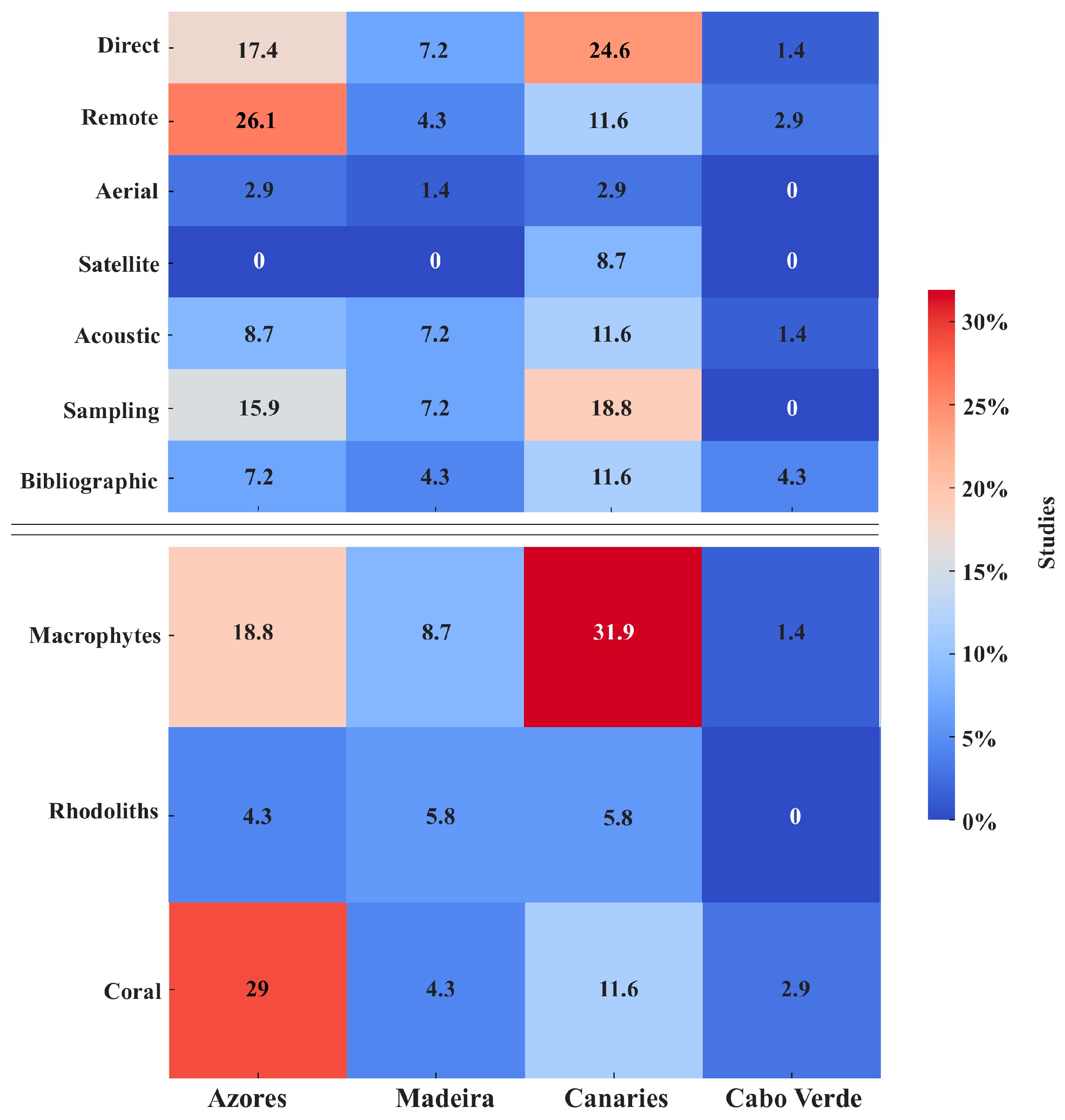


Disclaimer/Publisher’s Note: The statements, opinions and data contained in all publications are solely those of the individual author(s) and contributor(s) and not of MDPI and/or the editor(s). MDPI and/or the editor(s) disclaim responsibility for any injury to people or property resulting from any ideas, methods, instructions or products referred to in the content. |
© 2025 by the authors. Licensee MDPI, Basel, Switzerland. This article is an open access article distributed under the terms and conditions of the Creative Commons Attribution (CC BY) license (https://creativecommons.org/licenses/by/4.0/).