Review

Physically Based and Data-Driven Models for Landslide Susceptibility Assessment: Principles, Applications, and Challenges

1
Graduate School of Frontier Sciences, The University of Tokyo, 5-1-5, Kashiwanoha, Kashiwa 277-0882, Japan
2
School of Geoscience and Technology, Southwest Petroleum University, Chengdu 610500, China
3
Center for Spatial Information Science, The University of Tokyo, 5-1-5, Kashiwanoha, Kashiwa 277-8568, Japan
4
RIKEN Center for Advanced Intelligence Project, 1-4-1, Nihonbashi, Chuo City, Tokyo 103-0027, Japan
5
State Key Laboratory of Geohazard Prevention and Geoenvironment Protection, Chengdu University of Technology, Chengdu 610059, China
*
Author to whom correspondence should be addressed.
Remote Sens. 2025, 17(13), 2280; https://doi.org/10.3390/rs17132280
Submission received: 19 May 2025 / Revised: 22 June 2025 / Accepted: 30 June 2025 / Published: 3 July 2025

Abstract

Susceptibility assessment is a crucial task for mitigating landslide hazards. It includes displacement prediction, stability analysis, and location prediction for individual hillslopes or regional mountainous areas. Physically based models can assess landslide susceptibility with limited datasets by inputting physical parameters, albeit with some uncertainties. In contrast, data-driven models, primarily developed using machine learning and statistical algorithms, often provide acceptable predictive accuracy in assessing landslide susceptibility. They generally serve as practical tools for prediction but lack transparency and scientific interpretability. This review critically analyzes the strengths, limitations, and application scenarios of each model type, with a focus on recent advancements, practical applications, and challenges encountered. Furthermore, potential integration strategies are discussed to address the limitations of each approach, including hybrid models that combine the interpretability of physically based models with the predictive power of data-driven models. Finally, we suggest future research directions to improve landslide susceptibility assessments, such as enhancing model interpretability, incorporating real-time monitoring data, enhancing cross-regional transferability, and leveraging advancements in remote sensing, spatial data analytics, and multi-source data fusion.

1. Introduction

Landslides are a common and destructive geological phenomenon that not only cause severe damage to infrastructure but also often cause secondary disasters such as floods and debris flows. According to the global disaster risk reduction assessment report released by the United Nations Office for Disaster Risk Reduction, landslides will remain one of the geological disasters with the highest incidence in the world, resulting in a large number of casualties and billions of dollars in annual economic losses [1,2,3,4,5]. For example, between 1998 and 2017, landslides caused more than 18,000 deaths worldwide, and in some years, economic losses exceeded USD 10 billion [5]. Landslide susceptibility assessment aims to predict the likelihood of landslide occurrence in a given area [6,7]. Landslides result from complex interactions among factors such as earthquakes [8], rainfall [9], mechanical properties of rock mass [10], topographic and geomorphic conditions [11], groundwater fluctuations [12], the impact of climate change [13], and human engineering activities [14], such as slope cutting [15]. These interactions make landslide sensitivity assessment challenging but play a key role in landslide disaster risk assessment and management [16,17]. It informs land-use planning, disaster mitigation, and resource allocation by identifying high-risk zones [18,19,20].
The existing landslide susceptibility analysis models are generally classified into three categories: knowledge-driven, physically based, and data-driven models [21]. These models differ in terms of data requirements, interpretability, and applicability—ranging from expert judgment to physics-based simulations and statistical or machine learning algorithms. Further details on each category are provided in the following sections [21,22].
Physically based models assess landslide susceptibility by applying fundamental physical principles such as hydrological infiltration, pore water pressure variation, and slope stability [23]. Over the past few decades, such models have evolved from simple deterministic techniques to advanced numerical simulations integrating hydrological, geotechnical, and environmental data [24,25]. Initially, researchers used this method, primarily focused on simple static slope stability conditions. Recent physical models have incorporated dynamic processes due to improved computational capabilities and increased data availability. These dynamic processes include rainfall-induced landslides and landslides triggered by earthquakes, groundwater fluctuations, and other complex factors [26]. Physically based models effectively combine geospatial information with hydrological data, making them particularly useful for regional-scale landslide assessments [27]. Widely used examples of these models include the Shallow Landslide Stability Model (SHALSTAB) [28], Stability Index Mapping (SINMAP) [29], and Transient Rainfall Infiltration and Grid-Based Regional Slope Stability (TRIGRS) [30]. Recent studies have demonstrated the practicality of these models in real-world applications. In a landslide-prone region of Brazil, TRIGRS produced the most accurate susceptibility map among four physically based models when applied under heavy rainfall conditions, confirming its value for dynamic slope failure analysis [27].
Data-driven models typically use statistical analysis and machine learning algorithms to build predictive models from historical landslide data. Unlike physical models, they use big data analysis and pattern recognition to assess landslide susceptibility. Standard methods include logistic regression (LR) [31], random forest (RF) [32], and artificial neural networks (ANN) [31]. Deep learning techniques [33] have recently gained significant popularity, effectively improving the efficiency and accuracy of landslide susceptibility assessment. Yang et al. [34] proposed a model based on a convolutional neural network (CNN) that combines multispectral remote sensing images and digital elevation models (DEMs) for landslide susceptibility analysis. This model used multi-scale convolutional layers to extract spatial features, significantly improving prediction accuracy. Deep learning models excel at handling high-dimensional and complex data, but they require substantial computational resources and large training datasets [35]. Beyond machine learning approaches, recent studies have also integrated time-series remote sensing techniques with signal processing methods to analyze deformation responses of reservoir-area landslides to environmental triggers, providing critical insights for hazard mitigation [27].
Although significant progress has been made in landslide susceptibility assessment, most current research focuses on physical or data-driven models alone. Few studies have compared their advantages, limitations, and potential synergies [36]. Physical models provide physically interpretable results by integrating geological and hydrological parameters, but they typically require extensive input data and computational resources. This requirement makes them less suitable for large-scale or data-scarce regions [37]. Data-driven models utilize machine learning algorithms to analyze spatial patterns and nonlinear relationships; however, these models often act as “black boxes”, lacking physical interpretability and generality across different geological environments [36]. Comprehensive approaches that combine physical constraints with machine learning techniques have recently gained increased attention. However, systematic reviews addressing their applications, challenges, and future directions remain limited [37]. Given the growing demand for accurate and scalable landslide prediction methods, systematic and critical reviews are necessary to bridge the gap between physical and data-driven models, explore hybrid methods, and provide clear guidance for future research [37].
By reviewing the relevant literature and recent advances, this paper discusses the core principles, features, advantages, and limitations of these two models in practical applications. Furthermore, based on current research trends, this paper examines these models’ applicability and potential challenges under different scenarios. It discusses the integration of physical information with machine learning techniques, multi-source and multi-scale data fusion, parameter optimization, and uncertainty quantification, thereby enhancing transferability and interpretability to guide improvements in landslide prediction and disaster management.

2. Construction and Analysis of the Literature Database

2.1. Information on Articles

To establish a comprehensive literature database on landslide susceptibility analysis, we extensively searched the Web of Science and Google Scholar platforms, covering the period from January 2005 to December 2024. We recognized that journal papers on landslide susceptibility analysis published before 2005 are very limited. The search employed a combination of keywords, including “landslide”, “susceptibility”, “slope stability”, “sensitivity”, “modeling”, “machine learning”, “physically based model”, “data-driven model,” and “prediction.” This effort yielded a total of 3761 relevant articles. After removing duplicates and excluding studies published in local proceedings or lacking clear methodological descriptions, a final collection of 1078 peer-reviewed articles published in international journals and conference proceedings was retained.
To ensure the clarity and utility of the database, the extracted information from each article was systematically organized into four major categories: (A) bibliographic information, (B) regional and geographic information, (C) landslide characteristics and scenario context, and (D) methodology. These main categories are further divided into 19 sub-categories, as detailed in Table 1. For each of the 1078 selected articles, we collected the necessary information to annotate and populate these fields accordingly. We also recorded the number of citations for each article as of 24 March 2025, based on the Web of Science. Overall, the constructed database demonstrates considerable representativeness, as it encompasses a wide range of landslide-prone regions and various model types. In particular, regions such as Asia and Europe are well represented, reflecting both high research activity and landslide occurrence frequency. While contributions from Oceania and Africa are relatively limited, this pattern highlights existing research gaps rather than database imbalance. Similarly, the dataset includes a balanced number of physically based, data-driven, and hybrid models, ensuring that our subsequent analyses are comprehensive and reflective of current trends. The following sections outline the grouping principles and classification criteria adopted for each category and its corresponding sub-categories.

2.2. Overview of Whole Landslide Susceptibility Studies

Figure 1 illustrates the annual and cumulative numbers of landslide susceptibility articles from 2005 to 2024 based on the literature database. Interest in landslide susceptibility mapping has grown significantly over the past 20 years. Between 2005 and 2009, the number of published articles remained relatively low, totaling only 23 articles over the five years (4.6 articles per year on average), indicating that the topic was still in its infancy in academia. Since 2010, the number of publications has increased gradually. Following 2016, the annual output entered a period of rapid growth, with 38 articles published in 2016 and a cumulative total of 158 publications by that time, marking the beginning of broader academic involvement in landslide susceptibility assessment. Paola Reichenbach’s (2018) [38] review article on landslide susceptibility modeling and relevant terrain zoning statistical methods has received more than 1300 citations and is currently the most cited article in our statistics. Following 2021, there has been a significant increase in research articles, with the number of articles published each year exceeding 100 and reaching 224 in 2024. This trend increasingly indicates that the field has become a prominent research focus today and is expected to remain so.
Figure 2 illustrates the top ten journals in terms of the number of articles identified through analysis of the curated literature database. The five most productive journals, including Remote Sensing, Environmental Earth Sciences, Natural Hazards, CATENA, and Bulletin of Engineering Geology and the Environment, collectively published 29.7% of the 1078 articles. These journals are frequently cited in the landslide research community due to their strong focus on geohazards, remote sensing applications, and engineering geology. The following five journals—Geocarto International, Landslides, Sustainability, Geomatics Natural Hazards & Risk, and Geomorphology—account for an additional 23.3% of the total publications. The top 10 journals account for 53.0% of all articles in the dataset, highlighting a marked concentration of scholarly output in key outlets within geosciences, natural hazards, and environmental informatics.
After eliminating some missing data and unclear sites, we obtained data from 1071 research sites. The institutional affiliations of the authors, as extracted from their address fields, show a geographic trend of scholarly contributions. Figure 3 presents the top ten countries by author address frequency. Among these, China is the leading contributor, appearing in 1585 instances—far exceeding other nations. India, Vietnam, South Korea, and Iran follow China, each showing a significant presence. The dominance of Asian countries in the authorship underscores the regional research emphasis and strong institutional engagement with landslide susceptibility mapping and related technologies.
After eliminating some studies that did not specify a study region or employed global-scale or synthetic datasets for model validation, we obtained data from 1062 research sites. As shown in Figure 4, Asia holds a dominant position, accounting for 84.38%, indicating that the region is highly active in landslide-related research, likely due to the frequent geological disasters and significant investment in policy and scientific research. Europe accounted for 8.56%, showing a stable and continuous research output. Although South America and North America account for only 3.29% and 3.27%, they still reflect a certain degree of regional research attention. In these regions, the relatively lower recurrence of large-scale landslides rather than a lack of scientific interest may contribute to the smaller proportion of study sites. In contrast, research in Oceania and Africa accounts for around or even less than 1%, reflecting significant research gaps and development potential. In the future, global landslide susceptibility modeling efforts should prioritize strengthening data acquisition in under-researched regions and exploring model adaptability to develop a more globally representative and equitable disaster prediction system.

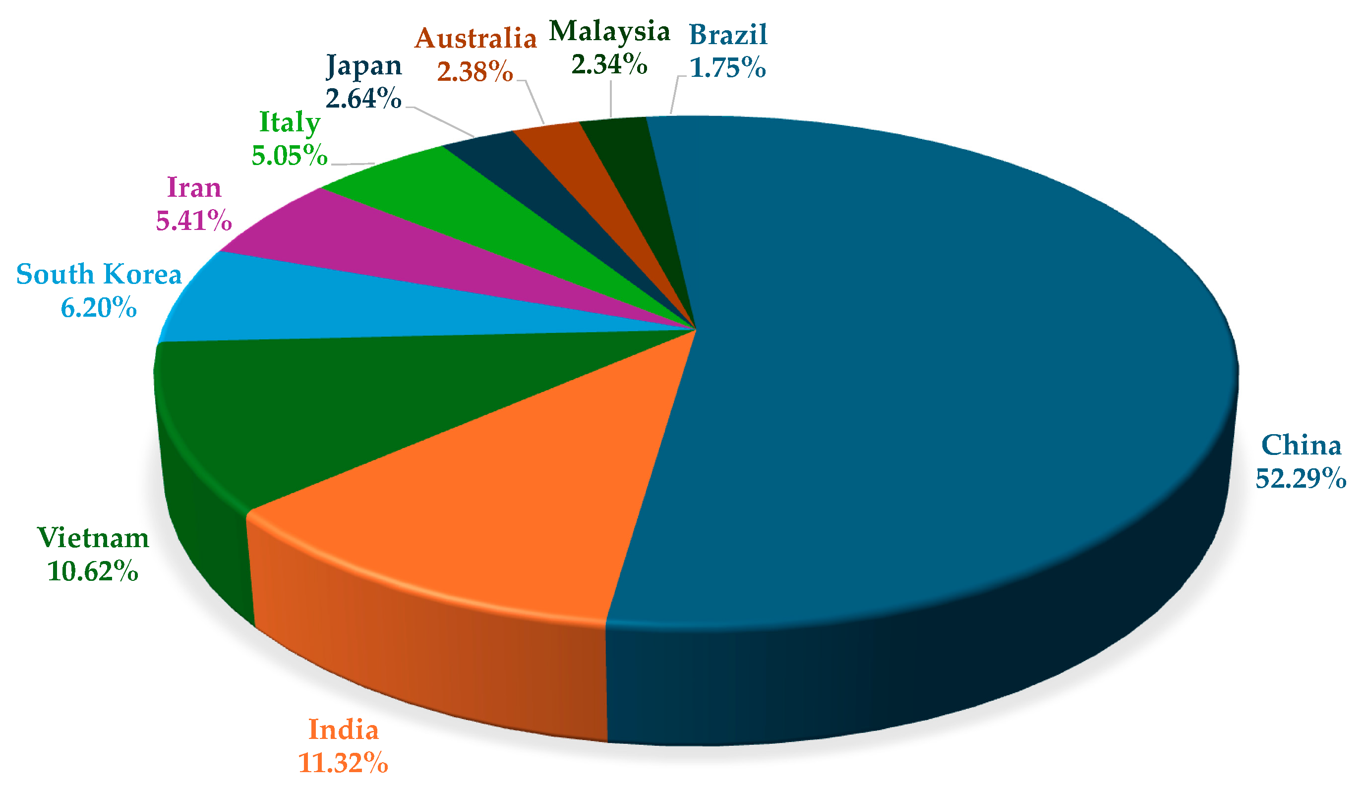
2.3. Overview of Studies Using Physically Based Models

Figure 5 shows the annual and cumulative publication numbers of landslide susceptibility studies employing physically based models between 2005 and 2024. The development of physical models is relatively steady. Until 2010, the number of publications per year was generally between two and three, indicating that the practical application was still relatively limited, although the theoretical foundation was already solid. After 2015, research popularity increased slightly, with an annual average of about five papers from 2015 to 2018, and the literature accumulation gradually increased. Since 2020, the number of publications has shown a moderate upward trend, reaching 6 in 2021, 8 in 2022, and 11 in 2023, a new high in recent years. Although the overall number is far less than that of data-driven methods, physical models remain essential in landslide susceptibility research due to their excellent interpretability and realistic characterization of mechanisms. Table 2 presents the five most cited articles that utilize physically based models. Some of these articles were published before 2010, indicating that research on this type of model started early. However, an article published in 2017 is also ranked, showing that research in this area is not outdated. Notably, three of the five studies focus on regions within Italy, indicating a regional concentration of research efforts in this area.
Various classical physical models on landslide susceptibility have been frequently cited in the literature. TRIGRS, SINMAP, and SHALSTAB are the most prominent, constituting the core framework of current physical modeling methods. As Figure 6 shows, TRIGRS ranked first with 41 citations, reflecting its ability to dynamically simulate the relationship between rainfall infiltration processes and slope stability. In particular, it performs well in predicting shallow landslides. It is followed by SINMAP, which has been cited 38 times. The model based on the terrain stability index is often used to assess landslide susceptibility at the regional scale. The SHALSTAB model ranked third with 36 citations; it also focuses on shallow landslide simulation and integrates topographic and hydrological elements, making it common in practical applications. These three models appear repeatedly in numerous studies, reflecting their methodological maturity and breadth of application. The infinite slope model, with 22 citations, remains widely used for preliminary slope stability assessment, especially for shallow landslides, due to its simplicity and ease of application. Other models, such as HYDRUS, a finite element model, have also been applied; however, they have received comparatively less attention and are more suitable for specific scenarios.

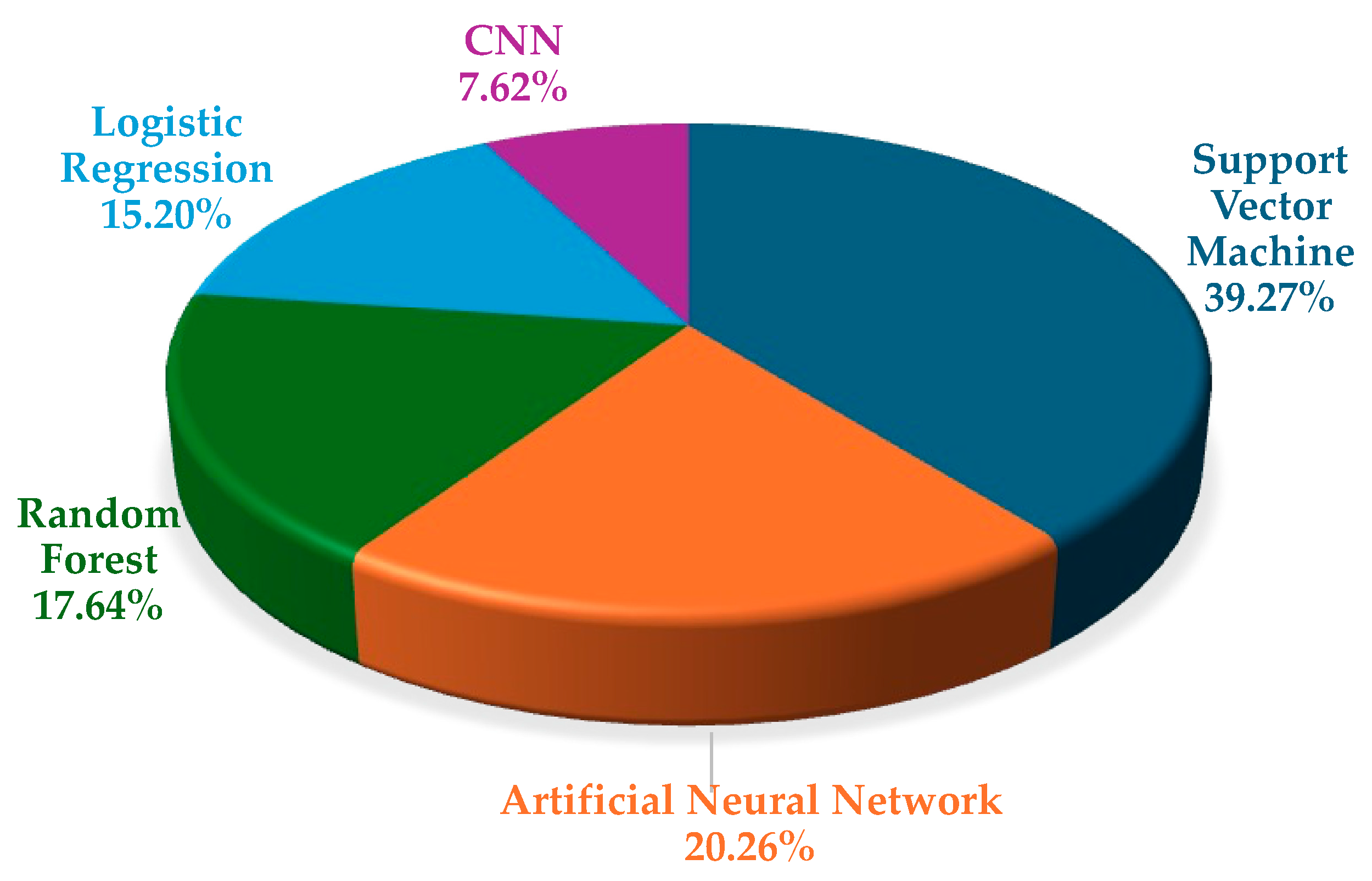
2.4. Overview of Landslide Susceptibility Studies Related to Data-Driven Models

Figure 7 shows the annual and cumulative number of publications on landslide susceptibility studies employing a data-driven approach from 2005 to 2024. The overall trend shows rapid development. Between 2005 and 2009, only 14 relevant studies were published, indicating that the field was still in its early stage of development. After 2010, the number of publications gradually increased, reaching 31 in 2016, totaling 174. Especially since 2019, research popularity has increased significantly, and the annual number of publications has continued to break records: 72 papers in 2019, 95 in 2020, 106 in 2021, 144 in 2022, 153 in 2023, and 219 in 2024, showing explosive growth. This trend suggests that, with technological development, data-driven methods have become mainstream in landslide susceptibility modeling and will continue expanding their application boundaries. Table 3 presents the five most-cited articles that utilize data-driven models. They are concentrated after 2010, with the most-cited one published in 2018, which aligns with the recent popular trend of this type of model.
In data-driven landslide susceptibility research, the application of machine learning models exhibits significant diversity and rapid growth. As shown in Figure 8, support vector machine (SVM) is currently the most frequently used model, appearing 917 times, indicating that its advantages in high-dimensional space classification problems are widely recognized. The second largest is ANN, which refers primarily to feedforward architectures such as multilayer perceptron. It appears 473 times and is commonly used in modeling complex geological environments due to its ability to learn nonlinear features effectively. RF ranks third with 412 mentions and has become popular in recent studies due to its robustness, particularly benefiting from its anti-overfitting mechanisms through bootstrap aggregation (bagging) and random feature selection. In addition, LR (355 times) and CNN (178 times) also show strong application popularity. This indicates that landslide susceptibility research is gradually moving towards a stage characterized by deep learning and ensemble learning, leveraging their advantages in flexibility, efficiency, and data-driven modeling.

3. Physically Based Models for Landslide Susceptibility Assessment

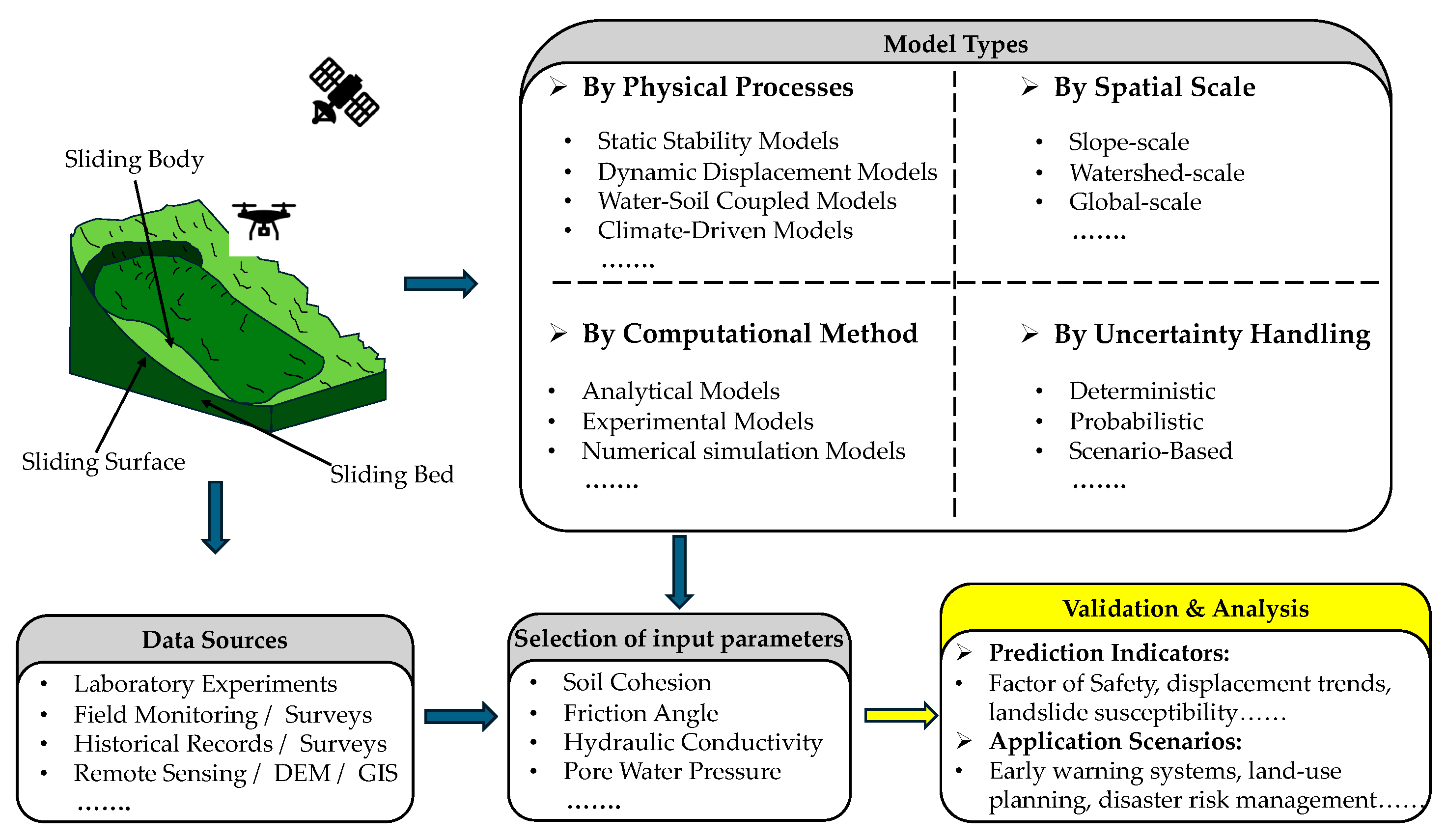
3.1. Principles for Physically Based Models

Physically based models are fundamental for assessing landslide susceptibility and rely on principles from mechanics, hydraulics, and materials science [37]. These models simulate slope stability processes, such as gravity, soil cohesion, friction, and changes in pore water pressure [44]. They use physical equations such as the Mohr–Coulomb failure criterion, Darcy’s law, and Newton’s laws to predict landslides under different environmental and geological conditions.
The Mohr–Coulomb criterion is used to calculate the shear strength τ of the soil as
τ = c + σ tan ϕ
where c is cohesion, σ is normal stress, and ϕ is the internal friction angle. This equation is applicable to shallow translational landslides, particularly under dry or partially saturated conditions with uniform material properties [47].
Darcy’s law, which governs groundwater seepage and pore pressure variation, is expressed as
q = k h
where q is specific discharge, k is hydraulic conductivity, and h is the hydraulic gradient [44]. This relationship holds for laminar flow in porous media, a key assumption in rainfall infiltration modeling.
These processes have been widely applied in previous studies for modeling slope failures under diverse hydrological and geological settings, particularly in shallow landslide scenarios [48,49]. Based on these rigorous physical equations widely used in engineering, the main advantage of physically based models is that they provide scientifically precise results, helping researchers understand landslide causes and mechanisms [37]. However, the required geological and hydrological parameters are often difficult to obtain in practical applications, or their measurement is uncertain [45]. Nevertheless, physically based models still play an irreplaceable role in fine-scale slope stability analysis [46] and medium to large scale regional landslide susceptibility mapping [50]. Especially when combined with real-time monitoring data, such models can support constructing landslide warning systems [51]. As computing power and remote sensing technology develop, these models become more reliable and practical for landslide susceptibility assessment. Figure 9 shows a general workflow of the physically based approaches for analyzing landslide susceptibility.

3.2. Selection of Input Parameters in Physically Based Models

When building physically based landslide susceptibility or hazard assessment models, selecting appropriate input parameters is critical to ensure the accuracy and reliability of simulation results. These parameters represent the geotechnical, hydrological, and environmental conditions directly controlling slope stability under various external triggers. Common input parameters include soil cohesion, internal friction angle, unit weight, and hydraulic conductivity. When the model involves soil–water coupling or transient seepage analysis, it usually requires more parameters such as pore water pressure, rainfall infiltration rate, and the soil–water characteristic curve [39,52].
In terms of data acquisition, input parameters typically come from a combination of laboratory experiments (e.g., direct shear and triaxial tests), field investigations (e.g., borehole logs and in situ permeability tests), real-time monitoring (e.g., pore pressure sensors and inclinometers), and historical data [53,54]. Remote sensing technology and DEMs provide essential data for terrain analysis and hydrological modeling.
However, field and laboratory methods are often affected by sampling disturbance, spatial heterogeneity, and equipment limitations. For example, cohesion and friction angle derived from laboratory shear tests may not reflect in situ conditions due to sample disturbance, while hydraulic conductivity is highly variable and difficult to measure consistently in the field. These measurement uncertainties can propagate through the model and significantly affect the final susceptibility predictions. Raia et al. conducted a sensitivity analysis on variations in soil depth and hydraulic conductivity using an extended version of the TRIGRS model (TRIGRS-P) applied in an Italian region. The study revealed that even minor changes in these parameters can significantly alter the spatial distribution of predicted landslide-prone areas, indicating a high sensitivity of the model to such inputs. The enhanced model notably improves predictive capability, especially in mountainous environments where parameter uncertainty is high [49].
In addition, sensitivity analysis is often used to assess the impact of parameter uncertainty on model outputs and to prioritize calibration of highly sensitive parameters [55]. In cases where data availability is limited, empirical estimates or literature-based parameter ranges can be used, although this inevitably increases the uncertainty of the model results.

3.3. Classification of Physically Based Models by Processes

Physically based models for landslide susceptibility assessment can be classified according to the physical processes they simulate. Landslides are influenced by various interconnected processes, including static stability, time-dependent displacement, water–soil interactions, and long-term climate effects [46]. Researchers can simulate landslide behavior better under different conditions, predict failure scenarios, and design mitigation strategies by understanding these processes and developing suitable models. Based on our literature review, the following content introduces several classic and widely used physically based models.

3.3.1. Static Stability Models

Static stability models provide a basic, physically based landslide evaluation method. The model analyzes the equilibrium relationship between the driving force and the resistance of the slope under static conditions to judge whether the slope is stable. Among them, one of the most popular methods is the infinite slope model [49], which assumes that the sliding surface is a plane parallel to the surface. The factor of safety (FS) in the model is defined as the ratio of the resistance, including the cohesion and friction of the soil, to the driving force, such as the gravitational component and external loads. When FS < 1, the slope is considered unstable [52].
Escobar-Wolf et al. [56] proposed and developed a GIS-based slope stability analysis tool, GIS-TISSA. It is based on an infinite slope model used explicitly for the spatial distribution prediction of shallow landslides. The research focuses on embedding traditional physical models, such as FS calculation, into modern geographic information systems, using slope data and various soil parameters, such as unit weight, the friction angle, and cohesion, as input. An outcome is the spatial distribution map of FS under different conditions. GIS-TISSA can provide fast and intuitive analysis support for landslide risk management using simple input data.
Researchers often choose the infinite slope model because of its simple structure and low input data requirements, including friction angle, cohesion, and unit volume weight. However, some idealized assumptions of the model may limit its applicability in complex geological conditions. The model usually assumes that the sliding surface is a homogeneous and continuous plane, and fails to consider the strengthening effects of factors, such as the complexity of geological structure, nonlinear constitutive behavior of soil, and the presence of vegetation roots [52]. If complex conditions such as root reinforcement, retaining structure, or non-plane failure surfaces are present, obtaining reliable results using only the infinite slope model is frequently difficult, and more parameters and complex numerical calculations are required.

3.3.2. Dynamic Displacement Prediction Models

Dynamic models on temporal slope deformation can simulate time-dependent processes to predict landslide displacement and failure. Researchers often use it to assess landslide responses to external disturbances by rainfall, earthquakes, or human activity [57].
The dynamic model mainly includes viscoelastic and viscoplastic methods, especially for simulating slow landslides. It can describe the deformation of geotechnical materials over time, such as creep and later acceleration [58]. Viscoelastic models are usually used to predict long-term displacement processes under relatively stable conditions. In contrast, viscoplastic models are more suitable for simulating instability mechanisms under stress concentration or increasing pore water pressure [59]. Another important application of this model is to study rainfall-induced landslides by coupling the model with precipitation data to simulate the displacement rate during continuous rainfall.
Li and others [60] studied a Holocene river-blocking landslide in southeastern Tibet, China, and conducted an in-depth analysis of the creep evolution process and failure mechanism of the landslide. The research team reviewed historical landslide monitoring data, combined them with field surveys and numerical simulations, and constructed a comprehensive viscoelastic–viscoplastic landslide evolution model, which thoroughly considered the long-term deformation characteristics of geological materials, especially the interaction with earthquake disturbances, rainfall infiltration, and groundwater changes.
The operation of the dynamic model relies on continuous field monitoring data, including key variables such as rainfall intensity, pore water pressure, and surface displacement. In addition, such models usually have high requirements on the accuracy of input data and computing resources, and their application is impractical if data are scarce or the technical capabilities of the models are limited [61].

3.3.3. Water–Soil Coupled Models

Water–soil coupled models can simulate the interaction between pore water pressure, seepage process, and slope stability, which are especially suitable for studying rainfall-induced landslides. These models are often used to analyze how water penetration reduces the effective stress of soil during heavy rainfall or rapid snowmelt, thus affecting the overall stability of the slope [62].
The saturated–unsaturated seepage model is a typical example of this method. It simulates the process of water migration in soil layers and its influence on the distribution of pore pressure. The key hydrological parameters, such as hydraulic conductivity and rainfall intensity, are usually considered in the model. In practical applications, the researchers used such models to assess the impact of water table fluctuations on slope stability [62]. For example, the SEEP/W module in GeoStudio software (25.1.0.1058) models the seepage process in detail. It is linked to the stress analysis module to reflect the coupling effect of seepage and stress fields.
Zhao [63] proposed a transient stability analysis method for the stability of unsaturated soil slopes under rainfall conditions. The author used the SEEP/W and SLOPE/W modules in GeoStudio for numerical simulation and performed a sensitivity analysis. The results showed that soil moisture characteristics and the permeability coefficient are key parameters affecting landslide evolution. In addition, the study also reflected the significant impact of input parameter errors on the prediction results of the coupled model.
Although the water–soil coupled model has high applicability in landslide process modeling, it requires high-quality input data, including detailed hydrogeological parameters, such as soil hydraulic characteristics and regional rainfall patterns. These data are often difficult to obtain in practical projects. In addition, in large-scale or long-term simulations, the coupling calculation of seepage and stress fields usually brings a high computational cost.

3.3.4. Climate-Driven Models

By combining meteorological data with physically based modeling frameworks, climate-driven landslide models serve as a critical tool for assessing the long-term impacts of climate change on slope stability. These models can be broadly classified based on their input climate data sources, temporal scales of analysis, and model coupling strategies. GCM-forced models rely on rainfall or temperature data derived directly from general circulation models, typically using monthly or daily outputs under different Representative Concentration Pathways (RCPs) or Shared Socioeconomic Pathways (SSPs); downscaled models apply statistical or dynamical downscaling methods to improve spatial resolution, often integrating local topography and land cover into regional-scale landslide predictions; event-based hybrid models simulate landslide occurrence under projected extreme events (e.g., short-term high-intensity rainfall or freeze–thaw cycles), combining scenario-based meteorological triggers with physically based slope stability simulations. Most models rely on rainfall and temperature series derived from general circulation models or regional climate models under different future climate scenarios (e.g., RCPs or SSPs), and are used to simulate landslide probability under increased frequency of extreme weather events such as intense rainfall or freeze–thaw cycles at high latitudes or altitudes [64].
Jakob et al. [64] evaluated the performance of a model from the Canadian Centre for Climate Modelling in simulating the antecedent rainfall and short-term heavy rainfall affecting landslides. The model was relatively successful in reproducing the statistical characteristics of antecedent rain, but the simulation accuracy for short-term rainfall was poor. Subsequently, the authors integrated monthly data from 19 global climate models and analyzed the changing trends of landslide-related rainfall factors in the 21st century under different greenhouse gas concentration scenarios. The results showed that antecedent rainfall is expected to increase by about 10% and short-term rain by about 6%, supporting the prediction that climate warming will increase the frequency of landslides in southern British Columbia.
Although climate-driven models show unique advantages in predicting long-term landslide risk, their application faces many challenges. For example, high uncertainties in climate predictions, significant differences in climate-geological responses at regional scales, and a lack of long-term, high-resolution geological hazard monitoring data limit the possibility of model validation and accuracy improvement. In addition, climate-driven models often rely on data with high spatial and temporal resolutions and advanced downscaling techniques, which limit their application in data-poor regions or under limited computational resources.

3.4. Classification of Physically Based Models by Spatial Scales

The application of physical models in landslide susceptibility assessment varies with spatial scale. At a small scale, the model usually focuses on a single slope or a landslide-prone area to determine whether the slope is stable and how it may slide [52,65]. Such models require a lot of detailed geological parameters, including shear strength, slope form, and pore water pressure. They are often accumulated bit by bit through field surveys and laboratory tests, costing a lot of time and money. The infinite slope model is widely used due to its simple structure and fast computation, and it is particularly suitable for dealing with landslides dominated by planar failure. If the terrain is complex and the soil exhibits nonlinear behavior, numerical simulation methods can be used. These methods are very popular in analyzing past landslides or engineering designs to understand landslide mechanisms. However, such models are highly dependent on data quality, have high computational costs, and are difficult to apply at regional or national scales. Especially in areas with variable geological conditions or a lack of unified data sources, the adaptability and portability of the model are low [66].
When models are applied at the regional scale, the diversity of topographic and environmental factors must be considered. Regional models usually evaluate the landslide susceptibility of an entire watershed or mountain area and use GIS and remote sensing data, including DEMs, to overlay factors such as slope, lithology, land cover, and hydrology. Models such as SHALSTAB and SINMAP use simplified physical formulas to predict stability for regional grid cells [39,41]. They are valuable in identifying high-risk areas and guiding land-use planning. However, regional models are usually of low resolution, require a cost to obtain appropriate maps, often ignore local heterogeneity, and rely on remote sensing data and high-resolution DEMs. These may lead to biased results in areas where data are scarce or of varying quality [21]. Nevertheless, regional models remain a key link between local fine-grained analysis and a global integrated perspective.
At the global scale, physically based models focus on the impact of macro factors such as climate, tectonics, or human activities on landslides. The large-scale datasets, such as global rainfall records, temperature anomalies, and global DEMs, are often used to identify potential high-risk areas, support international disaster reduction efforts, and assess the long-term impact of climate change on landslide activity [67]. NASA’s Landslide Hazard Assessment for Situational Awareness (LHASA) system [68] is a typical example, which provides near-real-time landslide hazard forecasts based on global precipitation data combined with susceptibility layers. However, the resolution of the global model is coarse and uses generalized parameters, and different data quality among countries may also lead to biased risk assessments for specific regions.
The choice of spatial scale of the model depends on the purpose of the study and data availability [21,39,41,67]. Local-scale models are good at accuracy and mechanism analysis, and are suitable for engineering design and landslide forensic analysis; regional-scale models take into account larger-scale assessments and computational efficiency, and are essential tools for regional planning and risk prioritization; and global-scale models can grasp the distribution and dynamics of large-scale landslides, providing a macro perspective.
However, applying physically based models across different spatial scales presents significant challenges in parameter generalization and scale conversion. Parameters such as soil hydraulic conductivity, cohesion, and slope gradient often vary non-linearly with scale and may lose physical meaning when directly transferred from local to regional or global models. Additionally, differences in spatial resolution between datasets (e.g., high-resolution DEMs for local models vs. coarse-resolution DEMs for global models) can result in spatial mismatches and reduced model accuracy. Data heterogeneity which arises from inconsistent data sources, measurement techniques, or temporal coverage, further complicates model integration across scales. To address these issues, several approaches have been proposed. Firstly, downscaling techniques (both statistical and dynamical) are used to translate coarse climate or geological data into fine-scale inputs suitable for localized models. Then, upscaling or aggregation methods are applied to synthesize detailed local measurements into regional or global parameter estimates, often using representative elementary areas or parameter regionalization. Moreover, multi-resolution data fusion and machine learning can also be employed to bridge gaps between datasets of varying resolution and origin.
These strategies are crucial for improving model interoperability and ensuring consistency when transitioning between scales, particularly in data-sparse or topographically complex regions.

3.5. Classification of Physically Based Models by Computational Methods

Computational methods are the foundation of physically based models for landslide susceptibility assessment. They help researchers simulate complex physical processes and predict potential landslide hazards. These methods differ in complexity, from simple analytical solutions to advanced numerical simulations and experimental validations. Each method has strengths and limitations, making it suitable for specific scenarios and research needs. In this section, we group these methods into analytical, numerical, and experimental models, explaining their basic principles, applications, and challenges.

3.5.1. Analytical Models

Analytical models are mathematical methods based on fundamental physical principles commonly used to assess slope stability and landslide susceptibility [56]. This model usually simplifies the problem by assuming that the soil property is uniform, the sliding surface is flat, and the slope is stable, allowing it to be solved more directly. The infinite slope model is a popular analytical model that uses soil cohesion, internal friction angle, slope angle, and pore water pressure to calculate FS and thus assess the slope stability [56].
Lian and Wu [69] proposed a new shallow failure model based on the classic infinite slope analytical model. By improving the sliding path and considering the unsaturated seepage effect, the model’s adaptability in rainfall-induced landslide scenarios is enhanced while maintaining the simplicity of calculation. Although idealized assumptions limit analytical models and cannot fully reflect complex geological structures and spatial variability, they are still significant in pre-screening landslides and identifying large-scale regional risks.
Because these models are based on idealized assumptions, they are limited in dealing with complex geometric structures or variable conditions in real terrain. For example, the temporal and spatial variations of pore pressure and the anisotropic behavior of soil are often challenging to accurately represent in analytical models. Nevertheless, with their high computational efficiency and low parameter requirements, analytical models still play an essential role in rapid assessment and initial risk identification, especially in regions with scarce data or limited resources.

3.5.2. Numerical Models

The numerical model can solve the intricate governing equations that describe the landslide process with contemporary computing techniques, overcoming the disadvantages of conventional analysis techniques when handling complex and nonlinear geological conditions [25]. These models can simulate material heterogeneity, nonlinear behavior, and coupling of various physical processes, and are widely used in landslide susceptibility and stability analysis. Common numerical methods include the categories described below.
The finite element method (FEM) is widely used because of its flexibility in dealing with complex boundary conditions and material heterogeneity. The method divides the slope into discrete elements, and by solving the stress, strain, and displacement equations for each node or element, it can simulate a variety of landslide-related factors, such as rainfall infiltration, seismic loads, and progressive failure processes. In engineering practice, ANSYS (2025 R1), ABAQUS (2025), and other commercial CAE software based on the FEM are widely used in slope stability and deformation analysis [70,71].
Unlike the FEM, the finite difference method (FDM) does not require the formulation of a global stiffness matrix and is particularly suitable for dynamic simulations involving large deformations. A typical software is FLAC3D (9.4), which is often used to analyze excavation-induced instability or time-dependent slope failure [71].
The discrete element method simulates the interaction between particles or blocks and is often used to reproduce the deformation and failure processes of discrete materials such as rock masses, debris flows, or talus flows. The method treats soil or rock mass as multiple discrete units and reconstructs the overall sliding behavior by calculating the motion trajectory of each particle. For example, the Particle Flow Code (PFC) can simulate the interaction between discrete elements with high precision, and is suitable for capturing complex failure mechanisms such as large deformation and fracture.
Kumar et al. [71] systematically reviewed the numerical methods used in slope stability research in recent years, with a particular focus on the comparative application of the FEM, the limit equilibrium method (LEM), and analytical methods. The article details the advantages of the FEM in simulating nonlinear constitutive relations, stress–strain responses, multi-factor coupling such as earthquakes and rainfall, and complex boundary conditions—especially in practical application scenarios using commercial software including ANSYS, PLAXIS (2024.3), and ABAQUS. The article also puts forward technical suggestions for addressing the challenges of numerical simulation, such as high computational cost and modeling complexity. It introduces emerging trends, including the development of hybrid methods (FEM–SPH) and data-driven models.
However, the establishment of numerical simulation models requires a large number of accurate input parameters, and their acquisition is complex. Moreover, the computational cost is high, and complex nonlinear problems such as plastic deformation and fluid–solid coupling require detailed meshing and a large amount of computing resources. It is also difficult to generalize on a large scale. Nevertheless, it remains an effective method in landslide research, especially for simulating complex physical processes.

3.5.3. Experimental Models

An experimental model simulates a landslide process in a controlled environment and is often used to validate numerical simulation results and provide key input parameters to physical models [72]. Under laboratory conditions, researchers can simulate the stress state through centrifuge tests or obtain key mechanical and hydrological parameters, such as soil shear strength and permeability, through direct shear and triaxial tests. Except for laboratory tests, artificially induced field landslide experiments provide a valuable opportunity to study landslide failure mechanisms, material response behavior, and the role of external triggers such as rainfall or earthquakes. These experiments help reveal the key physical phenomena in landslide processes and provide a realistic basis for theoretical modeling [72].
Jiang et al. [73] discuss a variety of landslide monitoring and experimental modeling techniques, especially in karst areas. They describe in detail how to use triaxial shear tests, centrifuge model tests, and artificial rainfall simulation tests to study the response behavior of landslide materials under different stress states and hydraulic conditions. They point out that these experiments not only help verify the accuracy of numerical models but also extract key parameters, such as pore pressure, shear strength, and permeability, to optimize the settings of physical models.
However, experimental models are often costly, complex, and limited in reproducibility and representation of natural conditions. Therefore, its application scope is relatively limited, and it is difficult to popularize on a large scale. Nevertheless, experimental models still play an irreplaceable role in deepening our understanding of the landslide occurrence mechanism and improving numerical simulation accuracy [72].

3.6. Classification of Physically Based Models by Uncertainty Handling Methods

Physically based models are inherently subject to uncertainty in both input parameters and prediction results. These uncertainties are burned in complex geological circumstances, measurement mistakes, and model assumptions that have been simplified. To solve these problems, uncertainty handling methods were developed. They are divided into deterministic, probabilistic, and scenario-based models [74,75,76].

3.6.1. Deterministic Models

Deterministic models have no random components and adhere precisely to physical and mathematical laws [75]. As a result, they consistently provide the same result from a given set of initial conditions. The infinite slope model, for example, uses fixed parameters like friction angle, cohesion, and saturation to assess landslide stability.
Using a deterministic approach, Bednarik et al. [69] performed a regional-scale analysis of the stability of shallow landslides in western Slovakia, focusing on assessing landslide activity with a slide surface depth of less than 5 m. Three typical working conditions were designed: dry, partially saturated, and fully saturated. Based on the results of field investigations and laboratory tests, FS values under different scenarios were calculated, and a landslide susceptibility map was created. The verification results show that most of the reactivated landslides since 2011 fall within the high-danger zone with FS < 1.0, indicating that this method has strong predictive power for landslide activity identification.
However, this approach does not consider the possible unpredictability of these features. Indeed, landslide processes are dynamic, and changes in conditions such as moisture content and stress can significantly alter friction angles and cohesion. Deterministic models typically fail to capture these dynamics.

3.6.2. Probabilistic Models

To overcome the limitations of deterministic methods, probabilistic models were used, which input values as random variables and aim to describe the uncertainty in both the inputs and the results [76]. A commonly used probabilistic method is the Monte Carlo simulation, which produces many possible outcomes by randomly selecting values for the input parameters. In landslide susceptibility assessment, factors such as friction angle, pore water pressure, and rainfall intensity can be simulated many times to generate probability distributions of stability measures. This method gives a clearer understanding of landslide risk by showing how likely a failure will occur.
Lari et al. [76] proposed a generalized framework called Probabilistic Landslide Hazard Analysis (PLHA), which can be applied to various landslide types and generate hazard curves and maps. The research assumes that landslide events conform to a Poisson process, and constructs hazard curves by calculating the probability of a landslide exceeding a given intensity within a specific time interval. It then generates a univalued hazard map to meet engineering specifications or planning requirements. The method combines several factors, such as the initial frequency of landslides, the runout frequency of remote slips, and the intensity of landslides in terms of impact energy or cover thickness. It also considers the uncertainty of spatial distribution. The method was successfully applied to the rockfall disaster triggered by the 2011 earthquake in Christchurch, New Zealand, and its practicability in risk management and mitigation structure design was verified.
Although this kind of model can effectively reflect the uncertainty of input parameters and the likelihood of landslide occurrence, it is usually necessary to perform multiple calculations and obtain many simulations to achieve statistically significant results. While the accuracy of the output is dependent on the quality of the input probability distributions a lot, for example, when the field data is scarce or uncertain, the setting of probability distributions often relies on assumptions and may not accurately reflect actual conditions.

3.6.3. Scenario-Based Models

Scenario-based models are created to evaluate landslide susceptibility under specific extreme conditions or hypothetical scenarios [74]. For example, using future rainfall scenarios, including those from the IPCC climate forecasts, variations in landslide risk under extreme rainfall can be simulated by varying rainfall amounts. Another prominent application of scenario-based models is to investigate the impact of human activity on slope stability. For example, these models can assess how different foundation designs may affect slope stability under different assumptions when constructing roads or buildings on some slopes.
Lombardo and Tanyas [74] proposed a new method to incorporate the temporal variation characteristics of earthquake surface motion into landslide susceptibility modeling, aiming to fill the gap that the temporal dimension of trigger factors is usually ignored in current statistical models. Based on the landslide event triggered by the 1994 Northridge earthquake, a Bayesian generalized additive model (GAM) was constructed. The model includes common topographic factors and the peak ground acceleration (PGA) generated by the earthquake. The authors ran 1000 simulations for 217 seismic scenarios in the study area and extracted the average landslide susceptibility distribution and 95% confidence interval for each scenario. This method combines the earthquake recurrence period with geological vulnerability analysis for the first time, enabling the landslide susceptibility model to be dynamically adjusted along the temporal dimension, thereby making it more aligned with the actual needs of landslide hazard risk analysis.
However, the accuracy of these models depends to a large extent on the validity of the assumptions made. The results may lack practical relevance if the assumed scenarios are too unrealistic.

3.7. Strengths and Limitations of Physically Based Models

Physically based models contribute to landslide susceptibility assessment because they are grounded in physical laws and provide clear, easy-to-understand findings [25,46,56]. These models help simulate crucial processes such as slope failure, water infiltration, and soil strength changes, making them useful in various environmental and engineering settings.
However, there are still some difficulties. The accuracy of these models largely hinges on input data, which can be hard to obtain. Some models also depend too much on simplifying assumptions that may not fully capture the terrain’s complexity. Under the complex geological background, the difficulty of model construction and solution is significantly increased, and using them at larger scales can be computationally demanding [70,71,72,73,74].
In landslide susceptibility modeling, the selection of different calculation methods often depends on the spatial scale of the research object, the complexity of the terrain, and the available data and resources. Future research on landslide susceptibility modeling will focus more on the integration and collaboration of methods. Under different spatial scales and data conditions, a reasonable combination of the efficiency of the analytical model, the accuracy of the numerical model, and the realistic reference value of the experimental model can maintain scientific rigor while leveraging the advantages of each approach, thereby improving the practicality and adaptability of the calculation results. In addition, with enhanced computing power and the development of remote sensing and monitoring technology, the integration of multi-source data will significantly improve the timeliness and reliability of the model and provide stronger technical support for landslide prediction [77]. It may be worthwhile to build hybrid models that integrate physical principles with data-driven methods and are supported by improvements in computational power and increasingly reliable data sources.

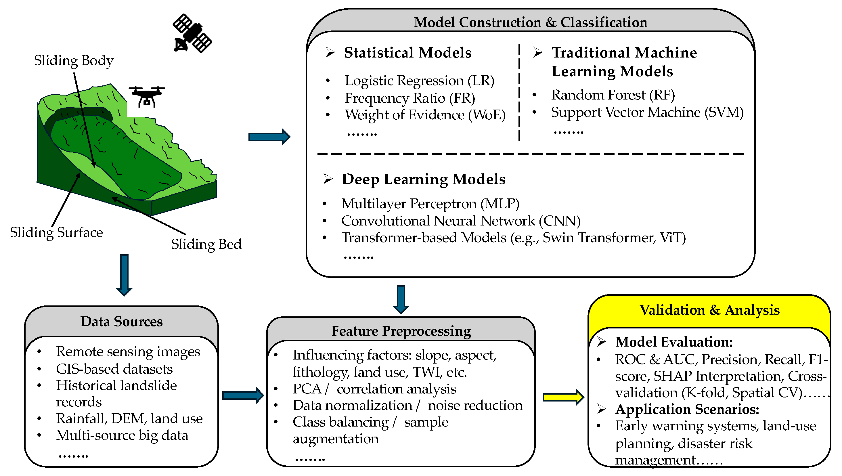
4. Data-Driven Models for Landslide Susceptibility Assessment

4.1. Principles for Data-Driven Models

In recent years, the rapid development of ‘3S’ technologies (remote sensing, geographic information systems, and global positioning systems), combined with advancements in artificial intelligence and various modeling approaches, has significantly broadened the application of data-driven models in landslide susceptibility evaluation and prediction. In landslide susceptibility assessment, data-driven methods mainly rely on large-scale, multi-source geological and environmental data, and use machine learning or deep learning algorithms to understand the patterns and internal mechanisms of landslide occurrence [44]. Compared with the traditional landslide models, data-driven methods offer stronger adaptive learning abilities and more effectively handle the nonlinear, high-dimensional, and complex nature of geological data [38,39,40].
Among various data-driven models, machine learning methods often perform better in landslide susceptibility evaluation. As indicated in Section 2, the research interest in its application continues to rise, showing a steady growth trend. Machine learning algorithms generally have stronger nonlinear modeling and autonomous learning capabilities than other data-driven models. By training on consistent input–output datasets, these models can effectively identify latent patterns within landslide data, handle uncertainties, and generate more realistic landslide susceptibility maps [44]. In addition, machine learning models show strong robustness against noisy data, do not rely on strict prior distribution assumptions, and require fewer statistical constraints than traditional models [38,46]. These advantages contribute to their broad applicability and stable performance in complex geological environments under suboptimal data conditions. In addition to traditional machine learning models, data-driven approaches encompass several statistics-based models, such as regression analysis and Frequency Ratio (FR) methods. Such methods are generally more interpretable when modeling the relationship between landslide controlling factors and landslide occurrence probability [38]. In recent years, deep learning models have gained increasing attention in landslide susceptibility assessment. Architectures such as CNN and Transformer-based attention mechanisms have shown promise in extracting high-level spatial-temporal features from remote sensing imagery, multi-temporal DEMs, and large-scale sensor-generated datasets [78].
In addition, with the development of big data technologies and knowledge engineering, some studies have attempted to introduce knowledge graphs and fuzzy logic reasoning into landslide analysis, establishing a deeper connection between data mining and domain-specific knowledge [79]. By integrating different types of data-driven models, researchers are expected to gain a more comprehensive understanding of landslide formation mechanisms and spatial distribution patterns, thereby building a more general and reliable landslide susceptibility prediction framework. Figure 10 illustrates the general workflow of data-driven approaches in landslide susceptibility assessment.

4.2. Selection of Input Parameters in Data-Driven Models

When constructing a landslide hazard or susceptibility assessment model, selecting appropriate influencing factors is crucial. An accurate understanding of the relationship between landslides and their precursors contributes to building more precise and adaptive prediction models [38]. Generally, the main influencing factors of landslides include topographic and geomorphic features (e.g., slope, aspect, topographic wetness index), geological and hydrological conditions (e.g., lithology, fault density, groundwater depth), meteorological factors (e.g., rainfall and rainfall intensity), and land cover characteristics (e.g., vegetation coverage and land-use types) [44,45,46]. It is important to note that the selection of input factors is often region-dependent, as geological, climatic, and geomorphological characteristics vary significantly across different landscapes. Therefore, while some influencing factors such as slope or land cover are commonly used, others may be specific to local geological contexts.
Regarding data acquisition, remote sensing imagery is often employed to efficiently extract a wide range of fundamental data, and GIS plays a key role in integrating, managing, and visualizing influencing factor data [32]. Principal Component Analysis (PCA) and correlation analysis are commonly applied to eliminate redundant information and reduce data noise [80]. However, PCA may overlook spatial dependencies, for which spatial-aware methods like Graph Convolutional Networks have been proposed.

4.3. Classification of Statistical Models for Landslide Susceptibility

In landslide susceptibility studies, statistical models have long served as a fundamental tool for assessing the spatial distribution of potential landslides. These models are based on mathematical theories, probabilistic frameworks, and predefined assumptions about the relationships between landslide occurrences and influencing factors. Traditional statistical methods, such as LR, FR, and weights-of-evidence (WoE), are widely used due to their strong interpretability and effectiveness in identifying correlations between environmental variables and landslide events [38].
Statistical models typically require fewer input parameters than more complex machine learning models and can explicitly demonstrate the importance and contribution of each variable. However, they have certain limitations in capturing highly nonlinear relationships and complex variable interactions, particularly in areas with heterogeneous geological and geomorphological conditions [32,38].

4.3.1. Logistic Regression

LR, a classical statistical method, is widely used in landslide susceptibility research. It constructs a probability model of landslide occurrence by treating influencing factors (e.g., slope, rainfall, lithology) as independent variables, and a binary variable indicating the presence or absence of landslides as the dependent variable. LR uses the logistic function to transform a linear combination of multiple independent variables into probability values, thereby enabling the classification of landslide-prone and non-prone areas.
One of the main advantages of LR lies in its strong interpretability. The estimated regression coefficients directly reflect the direction and intensity of each variable that influences landslide susceptibility [31]. In addition, LR is relatively easy to implement, requires no complex parameter tuning, and is well-suited for regional evaluation with limited data availability or moderate correlations among variables. However, since it is based on linear assumptions, its performance may be constrained when dealing with highly nonlinear relationships or complex environmental interactions [31,32].
A representative study by Ayalew and Yamagishi [81] applied a GIS-based LR model to evaluate landslide susceptibility in central Japan. The analysis incorporated various conditioning factors, e.g., slope, geology, soil, and land use, into a regression framework. The regression coefficients were used to estimate the direction and intensity of the influence of each variable on the probability of landslide occurrence. The results demonstrated that this method provides reliable spatial prediction and is both interpretable and easy to implement. It is particularly suitable for landslide research at a regional scale, with a moderate number of variables and constrained data conditions.

4.3.2. Frequency Ratio

The FR model is one of the most straightforward and widely used bivariate statistical methods in landslide susceptibility mapping. By calculating the ratio between the spatial frequency of landslide occurrences and the spatial frequency of each category of conditioning factors, FR offers a simple yet effective approach for assessing the correlation between environmental variables and landslide distribution. One key advantage of this model is its ease of implementation and low data requirements, making it particularly suitable for preliminary susceptibility assessments in data-scarce regions. Moreover, FR results are intuitively explanatory, where values greater than 1 indicate a positive correlation between this factor category and landslide occurrence [46]. However, as a bivariate approach, FR does not account for potential interactions among multiple factors, which may limit its applicability and predictive performance in complex geological environments [46].
Lee and Pradhan [82] applied FR and LR models to assess landslide susceptibility in Selangor, Malaysia. Their study incorporated multiple environmental factors into the FR framework, including slope, aspect, geology, and land use. The contribution of each factor category to landslide occurrence was quantified by calculating the ratio of landslide frequency to the total frequency within each class. The results demonstrated that the FR model maintained good interpretability and predictive capacity under limited data conditions, making it suitable for preliminary identification and regional-scale landslide risk assessments.

4.3.3. Weight of Evidence

The WoE model is a probabilistic statistical method based on Bayesian theory, widely used in landslide susceptibility assessment. WoE assumes that predictor variables are conditionally independent of each other and quantifies positive and negative weights by calculating the existence of landslide events within each category of conditioning factors. These weights are then used to assess the contribution of each category to landslide occurrence [83].
One of the main advantages of the WoE model is its ability to handle categorical variables and integrate multilayer spatial data within a GIS environment, making it particularly suitable for large-scale susceptibility mapping. In addition, WoE provides a clear, interpretable output, where a weight greater than zero indicates that the factor class has a positive effect on the occurrence of landslides, while a weight less than zero indicates a negative effect. However, like other bivariate models, WoE is sensitive to multicollinearity among variables, which can introduce bias into the estimation results [84].
Regmi et al. [85] used the WoE method to model landslide susceptibility in western Colorado, USA. The study transformed multiple spatial environmental factors, including slope, aspect, geomorphic unit, stratum, and soil type, into categorical variables and calculated positive and negative weights based on the spatial distribution of historical landslide points. A susceptibility map was then generated and verified with the actual landslide distribution, showing high prediction accuracy. This case study highlights the practical applicability of the WoE model in large-scale landslide risk identification, emphasizing its strengths in data adaptability, interpretability, and seamless integration with GIS platforms.

4.4. Classification of Traditional Machine Learning Models for Landslide Susceptibility

In recent years, machine learning (ML) models have become indispensable in landslide susceptibility assessment, providing a more flexible and efficient alternative to conventional statistical methods. Unlike statistical models that rely on predefined data distributions and linear assumptions, ML models handle high-dimensional datasets and uncover complex nonlinear patterns within the data [38,44]. Commonly used algorithms include SVM and RF, which have demonstrated strong performance in identifying and classifying landslide-prone areas. These models are well suited for structured data and have been widely applied in regional landslide susceptibility mapping studies.
However, their performance often suffers when data imbalances occur, while limitations in cross-regional transferability and the lack of uncertainty quantification hinder their wider application in operational risk mapping [86].

4.4.1. Support Vector Machines

SVM is a supervised learning algorithm widely applied to classification and regression tasks and has been extensively used in landslide susceptibility assessment [87]. Its core principle is finding an optimal hyperplane in the high-dimensional feature space that best separates landslide-prone and non-prone areas. SVM demonstrates strong robustness when handling small- to medium-sized datasets and can model nonlinear relationships between variables using kernel functions such as radial basis function (RBF) and polynomial kernels [88]. This flexibility enables SVM to capture complex patterns among landslide conditioning factors while maintaining high generalization performance [89]. However, the performance of SVM depends heavily on fine-tuning hyperparameters, including kernel types and regularization parameters. In addition, the computational cost can increase substantially with large datasets. Another notable limitation is the lack of model interpretability, which can hinder its application in practical decision-making scenarios [90].
Tien Bui et al. [91] employed SVM with remote sensing and GIS data to conduct landslide susceptibility prediction analysis for mountainous areas in Vietnam. Their study compared SVM with decision tree and naive Bayes classifiers, demonstrating that SVM was more effective in handling multidimensional input variables such as slope, aspect, landform type, and geological structure. The model exhibited good robustness to sample imbalance and was highly compatible with GIS platforms, making it suitable for practical landslide risk zoning. It outperformed other methods across several accuracy metrics, particularly in modeling the nonlinear relationships between topographic variables and landslide occurrences.

4.4.2. Random Forest

As a collection of multiple decision trees, RF fuses the predicted results of each tree through majority voting for classification or averaging for regression, effectively alleviating the overfitting problem commonly associated with single decision trees [92]. RF models show good adaptability when dealing with high-dimensional and large-scale datasets. They can evaluate the importance of each input variable, providing valuable insight into the factors influencing landslides [93]. In addition, RF is not sensitive to multicollinearity or noise in the data and is suitable for practical scenarios with complex geological environments and uneven data quality [94]. However, as the number of trees increases, the demand for computing resources increases. Moreover, due to its complex integrated structure, the decision path of individual trees is often difficult to trace, and the interpretability is still limited [95].
Behnia and Blais-Stevens [96] applied RF to model landslide susceptibility in Canada’s Yukon Territory. Based on landslide inventories compiled by the Geological Survey, they integrated various environmental factors such as slope, aspect, lithology, humidity index, and surface type to construct three models for debris flow, active layer landslides, and rock landslides. The study tested different positive and negative sample ratios and generated classification and probability maps. The success rate and prediction rate curves verified the model’s high performance. The results demonstrated that the RF method offers high accuracy and stability in landslide susceptibility assessment and provides essential reference values for infrastructure planning and risk management along the route.

4.5. Classification of Deep Learning Models for Landslide Susceptibility

Deep learning (DL) models represent a subset of machine learning that utilizes ANN with multiple hidden layers to automatically learn hierarchical feature representations from data. These models are particularly effective in processing large-scale, unstructured spatiotemporal data, making them increasingly popular in landslide susceptibility assessment.
Multilayer perceptron (MLP), the most basic form of feedforward neural networks, has been applied to landslide modeling tasks, especially when the data structure is suitable for fully connected architectures. More advanced architectures, such as CNN and Transformer-based models like Swin Transformer and ViT, have shown remarkable capabilities in extracting spatial and temporal features from remote sensing imagery and other geospatial data sources [44,97].
Deep learning models often achieve higher prediction accuracy in complex environments than traditional ML models. However, these models usually function as “black boxes”, making it difficult to interpret their internal mechanisms and decision rules [98]. Moreover, they typically require a substantial amount of labeled data and careful parameter tuning. Inadequate tuning can lead to overfitting, thereby reducing the generalizability of the model [99,100]. Deep learning models, including CNN and Transformer-based architectures, have been increasingly employed in landslide studies due to their capacity to capture complex spatial-temporal features [101].

4.5.1. Multilayer Perceptron

MLP is one of the most widely used deep learning models in landslide susceptibility analysis, primarily due to its strong ability to approximate the complex nonlinear relationships between landslide triggering factors and landslide occurrence [102]. Compared with traditional methods, MLP offers the advantage of automatically learning potential patterns from data without requiring prior assumptions about the distribution or relationships of input variables. This makes it particularly effective for handling high-dimensional datasets with complex variable interactions. MLP has been successfully applied in various geological case studies in recent years, demonstrating high prediction accuracy and strong generalization capability [102].
Bui et al. [103] conducted a landslide susceptibility mapping project in mountainous areas of Vietnam and compared the performance of four models: SVM, MLP, LR, and FR. The models were built using GIS data and multiple spatial variables, such as topography, land use, and geology. They were evaluated using area-under-the-curve (AUC) metrics and validation landslide point data. Results showed that the MLP model achieved the best performance across most indicators, particularly in capturing the nonlinear mechanisms underlying landslide occurrences.

4.5.2. Convolutional Neural Network

CNN has strong learning capabilities in nonlinear data feature extraction [104]. Compared with traditional machine learning methods, the advantage of CNN is that they do not require manual feature engineering, have high generalization ability, and can easily extract deep features to perform classification tasks. The CNN model learns the “image” information input into the network through iterative training and compares it with the given “image” feature information. When the error becomes lower than a predetermined threshold, the model stops learning and completes its training. The well-trained CNN model is then used to predict the susceptibility of regional landslide hazards [105]. Convolution operations can extract factor features, reduce computational cost, and accelerate model training. However, its limitations include many layers, a high parameter count, and significant computational complexity.
Wang et al. [106] conducted one of the earliest comparative studies applying CNN to landslide susceptibility mapping in Yanshan County, China. The study developed three novel data representation algorithms tailored to CNN architectures and incorporated sixteen environmental and geological factors. Through systematic training and validation, the proposed CNN frameworks demonstrated superior performance over optimized support vector machines and other popular machine learning approaches, with improvements of up to 7.45% in overall accuracy and 0.151 in the Matthews correlation coefficient. The results underscore the effectiveness of CNN in capturing complex spatial patterns for practical landslide prevention and risk management.

4.5.3. Transformer-Based Model

The Transformer model [107] was initially born in the field of natural language processing, but its powerful spatiotemporal modeling capabilities and the ability to capture long-distance dependencies have gradually introduced it into spatial prediction tasks such as landslide susceptibility analysis [108]. The Transformer, unlike traditional models that use a cyclic structure, dynamically allocates weights in the input sequence using a self-attention mechanism, making it more flexible and scalable when processing data with time–space coupling [109]. For example, when modeling landslide-triggering processes such as rainfall evolution, soil moisture change, and terrain dynamics, the Transformer can more accurately characterize the interactions between factors [110]. Its advantage lies in its ability to efficiently process data with strong sequence and complex structure, while maintaining high generalization ability [111].
Bao et al. [112] applied Transformer architectures (Vision Transformer and Swin Transformer) to landslide susceptibility mapping to address the limitations of traditional CNN in spatial feature capture. This paper selects a high-incidence landslide area, constructs a sample set containing multiple topographic and geological factors, and compares the Transformer models with traditional machine learning methods and CNN. The results show that the Swin Transformer achieved the best performance in terms of accuracy, F1 score, and AUC, while the ViT demonstrated stronger generalization ability, particularly in aligning with the actual spatial distribution of landslides. Although Transformer models show promising performance in spatial prediction tasks, their application in landslide susceptibility assessment remains in its early research stage. The current number of studies is limited, and practical implementation and generalization across diverse geological settings are still under exploration.

4.6. Evaluation Metrics and Methods

In landslide susceptibility studies, the performance evaluation of statistical models and machine learning models usually relies on the combination of threshold-independent and threshold-related indicators to ensure the accuracy of prediction results and the robustness of the model [38]. Among them, the receiver operating characteristic curve (ROC) and its corresponding AUC value are among the most widely used evaluation methods, and they can be used to evaluate the classification performance of various models [113]. The AUC value reflects the ability of the model to distinguish between landslide and non-landslide areas under different discrimination thresholds. When the value is closer to 1.0, the discrimination effect is better [114]. AUC itself has no analytical formula. It is an area calculated by integration or numerical methods. However, in geospatial applications, AUC may be artificially inflated due to spatial autocorrelation between training and test samples. To obtain more reliable performance estimates, spatial cross-validation schemes such as block k-fold or buffered leave-one-out validation should be considered. The ROC curve is generated by the following confusion matrix indicators:
True   Positive   Rate   ( TPR ) = T P T P + F N
False   Positive   Rate   ( FPR ) = F P F P + T N
There are five other metrics based on confusion matrices:
Accuracy = T P + T N T P + F P + F N + T N
Sensitivity = T P T P + F N
Specificity = T N T N + F P
Precision = T P T P + F P
F 1 = 2 Precision Recall Precision + Recall
They are widely used to provide a more nuanced insight into a model’s predictive power, especially when dealing with unevenly distributed datasets [115]. To further illustrate how different prediction outcomes affect confusion matrix-based indicators, Figure 11 presents a series of representative scenarios with varying TP, FP, TN, and FN distributions.
For statistical models, statistical significance tests for parameters, such as p-values, odds ratios (OR), or weight coefficients, are often combined to evaluate the rationality and explanatory power of the model. OR is defined as
O R = e β
where β is the regression coefficient. The weight coefficient (z) is
z = β S E β
where S E β is the standard error, and the z value can be used to calculate the p-values. These tests help to verify the correlation between each conditioning factor and the occurrence of landslides, thus enhancing the interpretability of the model [116].
In contrast, machine learning models, transfer learning, and Transformer-based approaches that emerged recently are often considered “black box” models despite their stronger fitting and generalization capabilities. To solve the current difficulty of explaining such models, interpretation methods such as feature importance assessment and Shapley additive explanation values (SHAP) are increasingly introduced to reveal the influence mechanism of each input variable on the predicted results [117]. SHAP is derived from the game theory Shapley value definition, and the formula is as follows:
ϕ i = S N { i } S ! N S 1 ! N ! f S { i } f S
where ϕ i is the SHAP value of the i-th feature; N is the set of all features; S is the feature subset; and f S is the predicted value of the model when only the feature subset S is used.
In addition, whether it is a statistical model or a machine learning model, cross-validation strategies such as K-fold cross-validation are
CV score = 1 K i = 1 K score i
The spatial cross-validation is a key component of the evaluation process.

4.7. Strengths and Limitations of Data-Driven Models

Data-driven models have many advantages in landslide susceptibility assessment. Compared with traditional physical models, these methods are more flexible and can handle multiple data types, including environmental factors such as terrain, geology, hydrology, and climate. They can effectively capture complex nonlinear relationships in landslide occurrence mechanisms [38]. Because they do not rely on detailed geomechanical modeling, data-driven models remain highly applicable even in regions with limited geological knowledge or scarce data availability. In addition, their good scalability makes them particularly suitable for susceptibility assessment at regional and even global scales, and their prediction performance can continue to improve as new data are accumulated and the model is further optimized, making them a cost-effective landslide prediction tool [44].
However, data-driven models also have limitations. Their predictive performance relies on the quality and integrity of the data. If there is too much bias or noise in the input data, it may significantly impact the model results, making the result unreliable [38]. In addition, because such models usually lack a clear physical basis, their ability to explain the mechanism of landslide induction is weak, and it may be difficult to provide strong support for decision making in some scenarios [117]. The problem of data imbalance, the risk of overfitting the model, and the lack of adaptability of the model when applied across regions also pose significant challenges in practical applications. At the same time, some subjectivity in feature selection and data preprocessing may also affect the consistency and reproducibility of model results [118]. Therefore, in the actual landslide susceptibility assessment, high-quality data support, a rigorous model validation process, and the assistance of physical models or domain expert knowledge should be combined to improve the reliability of data-driven methods.

5. Discussion and Prospect for Future Research

With the increasing demand for high-precision landslide susceptibility assessment, physically based and data-driven models have become indispensable tools in geological hazard research and management [119]. These two modeling methods have made remarkable progress in revealing the mechanism of landslide occurrence and improving the forecasting ability. Their results have been widely used in constructing early warning systems, land-use planning, disaster risk reduction, and other practical scenarios [38,39]. The effective integration of these models into risk management practice enhances the ability to identify landslide events prospectively and provides strong support for formulating scientific and reasonable intervention strategies. However, despite progress, physically based and data-driven modeling frameworks still face several challenges and unanswered questions [120,121]. The applicability, interpretability, data dependence, and cross-regional generalization ability of the models still need to be further discussed and optimized [122]. The following sections will focus on the key technical bottlenecks faced by current mainstream modeling methods and explore potential research directions to break through these limitations and promote the development of landslide susceptibility modeling to higher accuracy and greater adaptability.

5.1. Multi-Level Integration Framework for Landslide Susceptibility Prediction

Traditional physically based models possess a solid theoretical foundation and offer clear physical interpretability, but in practical applications, they are often constrained by strict input parameter requirements and high computational costs [123]. In contrast, data-driven models, particularly machine learning and deep learning approaches, are effective in capturing complex nonlinear relationships [124], yet they often lack physical interpretability and are highly dependent on data quality.
To overcome these limitations, we propose two strategic directions: (1) strengthening integration within each modeling paradigm; and (2) developing a hybrid framework that combines physically based and data-driven models to leverage their complementary advantages.
For physically based models, predictive capability across temporal scales can be enhanced by coupling static models (such as infinite slope models) with dynamic models (such as creep models or viscoelastic models), particularly when external triggers such as earthquakes or rainfall are incorporated. For data-driven models, ensemble approaches (e.g., weighted averaging and model stacking) and hybrid deep learning architectures (e.g., convolutional neural networks for spatial feature extraction and long short-term memory networks for capturing temporal dynamics) can be employed to improve model robustness and generalization capability. Incorporating geoscientific knowledge into the feature engineering and model construction processes is critical to enhancing interpretability and ensuring physical consistency.
The hybrid modeling framework can further improve performance by [125,126,127], for example, using the outputs of physically based models (such as safety factors, pore pressure, or displacement) as input features for machine learning models, or employing data-driven models to optimize key parameters within physical models. Such methodologies also facilitate the representation of multi-scale and multi-physical processes. Beyond simply using physical model outputs as features, future systems could adopt closed-loop architectures where machine learning models not only receive physical outputs as inputs, but also dynamically inform and update physical model parameters during iterative simulations. This bidirectional coupling would enable real-time calibration and adaptive learning, enhancing predictive accuracy under changing environmental conditions. However, due to their substantial computational demands, access to advanced computing resources is required [128].
In conclusion, both intra-model integration and hybrid modeling frameworks offer accurate, interpretable, and adaptable solutions for landslide susceptibility assessment, making them particularly suitable for data-scarce environments or geologically complex regions, and providing robust support for risk management and early warning systems.

5.2. Multi-Source and Multi-Scale Data Fusion for Physically Based and Data-Driven Models

The prediction of landslide susceptibility is essentially a complex systems problem involving multi-factor coupling. Both physically based models and data-driven models face challenges in data acquisition, integration, and processing, particularly in addressing spatial heterogeneity, temporal asynchrony, and the representation of multi-scale processes [129,130,131,132].
Physically based models rely on high-precision parameters such as slope angle, pore pressure, and permeability. However, these data are often incomplete and inconsistent at the regional scale, and static inputs struggle to capture dynamic processes such as rainfall infiltration or groundwater fluctuations [70,131]. In the future, multi-source real-time observational data (e.g., InSAR [133], LiDAR, hydrological monitoring) should be incorporated, and combined with data assimilation techniques to enhance the timeliness and dynamic simulation capabilities of the model. In addition, emerging sensing technologies such as distributed acoustic sensing and thermal imaging can be leveraged to capture more detailed processes of geological change.
Although data-driven models benefit from the broad spatial coverage of remote sensing and meteorological datasets, they remain constrained by issues such as limited spatial resolution, poor temporal consistency, and susceptibility to noise. Moreover, most current models lack the ability to dynamically adjust feature weights in response to regional environmental variability [104,132,134,135,136,137]. Attention should also be paid to data privacy and ethical concerns when using sensitive geospatial or social sensing data. In the future, fusion methods with regional awareness and feature adaptivity should be developed. For example, lightweight architectures integrating attention mechanisms and graph neural networks [138] can be utilized to reconstruct the influence weights of input features based on local conditions, thereby improving the model’s adaptability in geologically heterogeneous environments. Meanwhile, further exploration of the integration of causal inference with spatially dependent representations is expected to enhance both the generalization ability and interpretability of the models.
Furthermore, to address challenges related to limited data sharing and privacy concerns, federated learning and cloud–edge collaborative architectures may be explored to support cross-regional, distributed data integration and model cooperation. These strategies will help improve data accessibility and real-time responsiveness.
In conclusion, promoting the fusion of multi-source and multi-scale data is a key pathway to improving the accuracy, stability, and regional applicability of landslide susceptibility models. In the future, collaborative integration of static spatial datasets and dynamic sensing information should be strengthened to construct a fusion framework with spatiotemporal awareness, structural adaptability, and cross-platform interoperability.

5.3. Parameter Optimization and Uncertainty Quantification in Physically Based and Data-Driven Models

Physically based models and data-driven models play a critical role in the assessment of landslide susceptibility. However, both approaches continue to face significant challenges in parameter optimization and uncertainty quantification, which directly affect the reliability of prediction results. Physically based models rely on the precise calibration of geological and hydrological parameters, but these parameters are often constrained by the spatial heterogeneity of subsurface materials, the scarcity of field measurement data, and the inherent uncertainty of geological conditions [71,73]. Data-driven models, on the other hand, are sensitive to algorithmic structures and prone to issues such as overfitting, class imbalance, and limited representativeness of negative samples.
To address these limitations, physically based models can further incorporate techniques such as inverse analysis and Bayesian calibration, enabling dynamic parameter optimization using monitoring data (e.g., displacement and pore pressure) [139]. Among these methods, the Markov Chain Monte Carlo (MCMC) technique can effectively alleviate the problem of parameter equifinality [137,140]. In addition, uncertainty quantification methods such as Monte Carlo simulation [86] and reliability analysis are beneficial for assessing the probability distribution of landslide occurrence under varying environmental conditions. Future research should consider integrating real-time monitoring data with probabilistic modeling to enhance model responsiveness, interpretability, and regional adaptability.
In the context of data-driven modeling, improving model robustness and generalization remains a key challenge. Hyperparameter settings can be optimized through techniques such as Bayesian optimization and genetic algorithms to better adapt to diverse terrain and data conditions. Meanwhile, Bayesian neural networks [141], quantile regression forests, and ensemble learning approaches demonstrate strong capabilities in uncertainty estimation under high-noise or incomplete data scenarios. To mitigate issues such as spatial autocorrelation and class imbalance, spatial cross-validation, block-based sampling, and screening strategies based on Moran’s I index should be further promoted. Furthermore, Bayesian hierarchical models and multi-source parameter fusion approaches are conducive to achieving joint calibration across different regions and data sources, thereby narrowing the performance gap between theoretical models and practical applications.
In conclusion, advancing parameter optimization and uncertainty quantification strategies is essential for developing a more robust and practical landslide prediction system. A hybrid modeling framework incorporating data harmonization techniques such as Bayesian fusion offers promising solutions to core challenges including parameter equifinality and spatial autocorrelation. Overall, the systematic optimization of the modeling framework remains a critical direction for future research.

5.4. Enhancing Regional Transferability of Physically Based and Data-Driven Models

At present, the landslide susceptibility model still faces significant challenges in cross-regional applications. Physical models usually rely on geological and hydrological parameters of specific regions, such as soil cohesion, permeability coefficient, and slope geometry. These parameters are significantly affected by stratigraphy, climate, and geomorphic conditions and are difficult to be directly reused in other regions. Even if the model itself has a solid theoretical foundation, its transfer often requires a large number of parameter reconstructions and calibrations, resulting in limited regional scalability. Data-driven models also face the problem of “domain shift”. After being trained in the original area, the performance of the model declines in the new area, which limits its large-scale deployment and practical application.
In the future, to enhance regional transferability, there can be two strategies: One is to construct an adaptive data input mechanism and a modular physical model framework. By introducing globally accessible data sources (such as DEM, climate, lithology, and remote sensing deformation monitoring), the portability of parameters can be improved, and a physical model architecture that can flexibly switch regional parameter modules can be developed to reduce recalibration costs. Second, strengthen the cross-regional learning mechanism, especially by introducing strategies such as domain adaptation, adversarial transfer, and meta-learning in data-driven models, to learn the common representations of landslide-prone areas among different regions and weaken the reliance on specific training samples.
Furthermore, developing the cross-domain fusion mechanism of the physical–data hybrid model and taking the output of the physical model as the prior information or constraint condition of the data-driven model can effectively enhance the stability and interpretability of the model under complex geological conditions. Further introduce the weighting strategy based on uncertainty estimation to enable the model to dynamically adjust the confidence level of physical results in different regions, thereby achieving more flexible and reliable transfer and deployment.
In conclusion, enhancing the cross-regional adaptability of the model is the key to achieving large-scale practical application of landslide prediction. Future research should focus on promoting cross-domain data integration, optimization of transfer learning strategies, and design of fusion model architectures, to build a more flexible, scalable, and robust landslide prediction system, and serve geological disaster monitoring and early warning work at multiple regional and even global scales.

5.5. Improving Interpretability in Physically Based and Data-Driven Models

In the assessment of landslide susceptibility, the interpretability of the model is directly related to the effectiveness of engineering, decision making, and risk communication. The physical model is based on the theories of geomechanics and hydrology. Its output can better reflect the actual physical process and therefore has inherent transparency [39]. However, it often adopts simplified assumptions (such as smooth failure surfaces, homogeneous soil layers, and steady-state hydrology), which limits the explanatory power under complex geological conditions [70,73].
In the future, dynamic data assimilation technology should be further introduced. Wang et al. [142] carried out the research, and inspired the idea that by using InSAR, GNSS, and real-time hydrological monitoring data, the model output should be continuously calibrated and updated to enhance the response capability to environmental changes. Meanwhile, constructing a multi-physics coupling platform and integrating uncertainty expression mechanisms (such as parameter confidence intervals) will provide higher practicability and reliability for physical models.
Unlike this, although data-driven models can capture complex nonlinear relationships, they are often regarded as “black boxes” and lack clear causal mechanisms [38]. Therefore, in the future, based on the existing post-interpretation methods such as SHAP and LIME [127,143], models of embedded interpretability within the structure, such as prototype learning networks and neuro-symbolic hybrid systems, should be explored to achieve transparency throughout the entire process from data input to predicted output. Meanwhile, the attention mechanism is introduced to reveal the key spatiotemporal characteristics and enhance the explanatory power of the model and the credibility of its application.
Overall, although physical models have theoretical advantages and data-driven models excel in capturing complexity, both urgently need to further enhance interpretability through dynamic data integration, uncertainty quantification, and structural innovation. Future research should focus on the development of interdisciplinary visualization tools and build a dynamic, transparent, and traceable model interpretation ecosystem, so as to better serve high-risk decision making and practical engineering applications.

6. Conclusions

This review systematically organizes the current development status of physically based models and data-driven models in the assessment of landslide susceptibility, with a focus on analyzing their fundamental principles, application domains, data requirements, and computational frameworks. By summarizing the current research landscape and identifying existing challenges, it proposes several recommendations and perspectives for future research directions in this field. A clear research framework is constructed, which serves as a valuable reference for researchers and engineering practitioners to select and analyze models under specific conditions. At the same time, it highlights the key distinctions and complementary advantages among different modeling paradigms, providing a foundation for improving predictive accuracy, achieving disaster risk reduction, and guiding future research trajectories.
Based on a peer-reviewed literature database, this paper systematically reviews the overall research trends in landslide susceptibility modeling over the past two decades. The database is highly representative both geographically and methodologically, and the number of related publications has shown a steady increase in recent years. The included models are mainly physically based models and data-driven models. Since 2016, studies on data-driven models have experienced rapid growth and become a mainstream direction, while physically based models continue to be steadily applied due to their physical interpretability and solid theoretical foundations. The analysis also reveals regional imbalances in the current research landscape, such as the relatively limited contributions from Oceania and Africa. It emphasizes the need to enhance the geographical coverage of data collection and model validation, as well as to promote cross-regional collaboration and the integration of diverse modeling strategies.
Physically based models, due to their strong theoretical grounding in geotechnical and hydrological processes, remain a cornerstone in landslide susceptibility assessment. This paper classifies and reviews representative models according to physical processes, spatial scales, computational methods, and uncertainty handling strategies, and conducts in-depth analyses of the structural logic and application scenarios of infinite slope models, water–soil coupled models, dynamic displacement models, and climate-driven frameworks. The review further notes that model selection and parameter sensitivity are significantly influenced by terrain complexity, analysis scale, and data availability, which imposes certain limitations on their broad applicability.
This paper also analyzes the structure and modeling logic of data-driven approaches, underscoring the importance of factor selection and dataset construction in ensuring predictive reliability. LR, FR, and WoE are suitable for preliminary assessments due to their interpretability and computational efficiency. SVM and RF demonstrate strong performance in handling high-dimensional and noisy data; meanwhile, deep learning architectures such as MLP, CNN, and Transformer exhibit significant potential in spatiotemporal feature extraction. Evaluation metrics commonly used in the literature are also summarized. Nonetheless, data-driven models remain sensitive to input data quality and still face limitations regarding model interpretability.
Although considerable progress has been achieved in recent research, key challenges remain. Therefore, this paper proposes five major future directions for landslide susceptibility modeling: (1) advancing the construction of multi-level integrated modeling frameworks; (2) developing strategies for multi-source and multi-scale data fusion; (3) improving parameter optimization and uncertainty quantification techniques; (4) enhancing the cross-regional generalization capability of models; and (5) increasing the interpretability of both physically based and data-driven models. By integrating current technological advancements—such as attention mechanisms, transfer learning, Bayesian calibration, and interpretable artificial intelligence—this review underscores the importance of constructing a modeling system that is adaptive, scalable, and highly transparent. These state-of-the-art techniques are expected to narrow the gap between theoretical research and practical applications, providing more robust scientific support for landslide early warning and risk management. Future development requires interdisciplinary collaboration, responsible data governance, and scalable algorithmic architectures to facilitate the translation of scientific knowledge into actionable strategies for disaster prevention and mitigation.

Author Contributions

Conceptualization, C.Y.; methodology, C.Y. and H.W.; validation, C.Y. and Y.T.; writing—original draft preparation, C.Y., H.W., and Y.T.; writing—review and editing, T.O., X.P., and Y.W.; supervision, T.O. All authors have read and agreed to the published version of the manuscript.

Funding

This research was supported by the Graduate School of Frontier Sciences, The University of Tokyo, through the Challenging New Area Doctoral Research Grant (Project No. C2307).

Data Availability Statement

The data presented in this study are available on request.

Acknowledgments

We thank the authors and co-authors of the references cited, based on which the discussions and insights are presented in this survey. We also appreciate the academic editors and anonymous reviewers for their helpful comments and constructive suggestions.

Conflicts of Interest

The authors declare no conflicts of interest. The funders had no role in the design of the study; in the collection, analyses, or interpretation of data; in the writing of the manuscript; or in the decision to publish the results.

References

  1. Turner, A.K.; Schuster, R.L. Landslides: Investigation and Mitigation; Special Report 247; National Academy Press: Washington, DC, USA, 1996; ISBN 9780309061513. [Google Scholar]
  2. Zhao, C.; Lu, Z. Remote sensing of landslides—A review. Remote Sens. 2018, 10, 279. [Google Scholar] [CrossRef]
  3. Metternicht, G.; Hurni, L.; Gogu, R. Remote sensing of landslides: An analysis of the potential contribution to geo-spatial systems for hazard assessment in mountainous environments. Remote Sens. Environ. 2005, 98, 284–303. [Google Scholar] [CrossRef]
  4. Lan, H.; Liu, X.; Li, L.; Li, Q.; Tian, N.; Peng, J. Remote sensing precursors analysis for giant landslides. Remote Sens. 2022, 14, 4399. [Google Scholar] [CrossRef]
  5. United Nations Office for Disaster Risk Reduction (UNDRR). Available online: https://www.undrr.org/ (accessed on 27 February 2025).
  6. Van Westen, C.J.; Castellanos, E.; Kuriakose, S.L. Spatial data for landslide susceptibility, hazard, and vulnerability assessment: An overview. Eng. Geol. 2008, 102, 112–131. [Google Scholar] [CrossRef]
  7. Zhang, Z.; Sun, J. Regional Landslide Susceptibility Assessment and Model Adaptability Research. Remote Sens. 2024, 16, 2305. [Google Scholar] [CrossRef]
  8. Ge, R.; Chen, J.; Ma, S.; Tan, H. Inventory and Spatial Distribution of Landslides on the Eastern Slope of Gongga Mountain, Southwest China. Remote Sens. 2024, 16, 3360. [Google Scholar] [CrossRef]
  9. Liu, S.; Du, J.; Yin, K.; Zhou, C.; Huang, C.; Jiang, J.; Yu, J. Regional early warning model for rainfall induced landslide based on slope unit in Chongqing, China. Eng. Geol. 2024, 333, 107464. [Google Scholar] [CrossRef]
  10. Zheng, W.; Cao, Y.; Fan, W.; Liang, X.; Yuan, S.; Guo, Q.; Zhang, J. Influence of faults on landslide formation and distribution: Insights from the Hanwang Fault Zone in the Qinling-Daba Mountains, China. Geomorphology 2025, 472, 109603. [Google Scholar] [CrossRef]
  11. Gao, L.; Zhang, L.M.; Chen, H.X.; Fei, K.; Hong, Y. Topography and geology effects on travel distances of natural terrain landslides: Evidence from a large multi-temporal landslide inventory in Hong Kong. Eng. Geol. 2021, 292, 106266. [Google Scholar] [CrossRef]
  12. Liu, Q.; Jian, W.; Nie, W. Rainstorm-induced landslides early warning system in mountainous cities based on groundwater level change fast prediction. Sustain. Cities Soc. 2021, 69, 102817. [Google Scholar] [CrossRef]
  13. Miklin, L.; Podolszki, L.; Gulam, V.; Markotić, I. The Impact of Climate Changes on Slope Stability and Landslide Conditioning Factors: An Example from Kravarsko, Croatia. Remote Sens. 2022, 14, 1794. [Google Scholar] [CrossRef]
  14. Li, Y.; Wang, X.; Mao, H. Influence of human activity on landslide susceptibility development in the Three Gorges area. Nat. Hazards 2020, 104, 2115–2151. [Google Scholar] [CrossRef]
  15. Kaushal, S.; Thanveer, J.; ul Islam, S.M.; Negi, A.; Dhanshyan, A.; Beetan, Y.; Subramanian, S.S.; Sajinkumar, K.S.; Yunus, A.P. Unveiling the amplifying impact: Anthropogenic activities and the two-fold surge in landslides in the Lesser Himalayas. CATENA 2025, 250, 108771. [Google Scholar] [CrossRef]
  16. Yang, Z.; Liu, C.; Nie, R.; Zhang, W.; Zhang, L.; Zhang, Z.; Li, W.; Liu, G.; Dai, X.; Zhang, D.; et al. Research on uncertainty of landslide susceptibility prediction—Bibliometrics and knowledge graph analysis. Remote Sens. 2022, 14, 3879. [Google Scholar] [CrossRef]
  17. Bao, H.; Zeng, C.; Peng, Y.; Wu, S. The use of digital technologies for landslide disaster risk research and disaster risk management: Progress and prospects. Environ. Earth Sci. 2022, 81, 446. [Google Scholar] [CrossRef]
  18. Fell, R.; Corominas, J.; Bonnard, C.; Cascini, L.; Leroi, E.; Savage, W.Z.; JTC-1 Joint Technical Committee on Landslides and Engineered Slopes. Guidelines for landslide susceptibility, hazard and risk zoning for land use planning. Eng. Geol. 2008, 102, 85–98. [Google Scholar] [CrossRef]
  19. Kumari, S.; Agarwal, S.; Agrawal, N.K.; Agarwal, A.; Garg, M.C. A Comprehensive Review of Remote Sensing Technologies for Improved Geological Disaster Management. Geol. J. 2025, 60, 223–235. [Google Scholar] [CrossRef]
  20. Ali, R.A.; Mannakkara, S. Phased post-disaster recovery challenges: 2016–2017 floods and landslides in Colombo and Kalutara, Sri Lanka. Int. J. Disaster Risk Reduct. 2024, 111, 104728. [Google Scholar] [CrossRef]
  21. Wei, X.; Zhang, L.; Gardoni, P.; Chen, Y.; Tan, L.; Liu, D.; Du, C.; Li, H. Comparison of hybrid data-driven and physical models for landslide susceptibility mapping at regional scales. Acta Geotech. 2023, 18, 4453–4476. [Google Scholar] [CrossRef]
  22. Yu, L.; Zhou, C.; Wang, Y.; Cao, Y.; Peres, D.J. Coupling data- and knowledge-driven methods for landslide susceptibility mapping in human-modified environments: A case study from Wanzhou County, Three Gorges Reservoir Area, China. Remote Sens. 2022, 14, 774. [Google Scholar] [CrossRef]
  23. Volkwein, A.; Schellenberg, K.; Labiouse, V.; Agliardi, F.; Berger, F.; Bourrier, F.; Dorren, L.K.A.; Gerber, W.; Jaboyedoff, M. Rockfall characterisation and structural protection—A review. Nat. Hazards Earth Syst. Sci. 2011, 11, 2617–2651. [Google Scholar] [CrossRef]
  24. Terlien, M.T. The determination of statistical and deterministic hydrological landslide-triggering thresholds. Environ. Geol. 1998, 35, 124–130. [Google Scholar] [CrossRef]
  25. Van Asch, T.W.; Malet, J.P.; van Beek, L.P.; Amitrano, D. Techniques, issues and advances in numerical modelling of landslide hazard. Bull. Soc. Géol. Fr. 2007, 178, 65–88. [Google Scholar] [CrossRef]
  26. Miao, F.; Wu, Y.; Xie, Y.; Yu, F.; Peng, L. Research on progressive failure process of Baishuihe landslide based on Monte Carlo model. Stoch. Environ. Res. Risk Assess. 2017, 31, 1683–1696. [Google Scholar] [CrossRef]
  27. do Pinho, T.M.; Augusto Filho, O. Landslide susceptibility mapping using the infinite slope, SHALSTAB, SINMAP, and TRIGRS models in Serra do Mar, Brazil. J. Mt. Sci. 2022, 19, 1018–1036. [Google Scholar] [CrossRef]
  28. Dietrich, W.E.; Bellugi, D.; Real de Asua, R. Validation of the shallow landslide model, SHALSTAB, for forest management. Land Use Watersheds Hum. Influ. Hydrol. Geomorphol. Urban For. Areas 2001, 2, 195–227. [Google Scholar] [CrossRef]
  29. Pack, R.T.; Tarboton, D.G.; Goodwin, C.N. The SINMAP Approach to Terrain Stability Mapping. Available online: https://digitalcommons.usu.edu/cee_facpub/2583/ (accessed on 27 February 2025).
  30. Alvioli, M.; Baum, R.L. Parallelization of the TRIGRS model for rainfall-induced landslides using the message passing interface. Environ. Model. Softw. 2016, 81, 122–135. [Google Scholar] [CrossRef]
  31. Kalantar, B.; Pradhan, B.; Naghibi, S.A.; Motevalli, A.; Mansor, S. Assessment of the effects of training data selection on the landslide susceptibility mapping: A comparison between support vector machine (SVM), logistic regression (LR) and artificial neural networks (ANN). Geomat. Nat. Hazards Risk 2018, 9, 49–69. [Google Scholar] [CrossRef]
  32. Chen, W.; Xie, X.; Wang, J.; Pradhan, B.; Hong, H.; Bui, D.T.; Duan, Z.; Ma, J. A comparative study of logistic model tree, random forest, and classification and regression tree models for spatial prediction of landslide susceptibility. CATENA 2017, 151, 147–160. [Google Scholar] [CrossRef]
  33. Chen, Q.; Ge, Y.; Tang, H. Rock discontinuities characterization from large-scale point clouds using a point-based deep learning method. Eng. Geol. 2024, 337, 107585. [Google Scholar] [CrossRef]
  34. Yang, X.; Liu, R.; Yang, M.; Chen, J.; Liu, T.; Yang, Y.; Chen, W.; Wang, Y. Incorporating landslide spatial information and correlated features among conditioning factors for landslide susceptibility mapping. Remote Sens. 2021, 13, 2166. [Google Scholar] [CrossRef]
  35. Chen, X.W.; Lin, X. Big data deep learning: Challenges and perspectives. IEEE Access 2014, 2, 514–525. [Google Scholar] [CrossRef]
  36. Chen, L.; Ma, P.; Fan, X.; Wang, X.; Ng, C.W.W. A knowledge-aware deep learning model for landslide susceptibility assessment in Hong Kong. Sci. Total Environ. 2024, 941, 173557. [Google Scholar] [CrossRef] [PubMed]
  37. Feng, D.; Beck, H.; Lawson, K.; Shen, C. The suitability of differentiable, physics-informed machine learning hydrologic models for ungauged regions and climate change impact assessment. Hydrol. Earth Syst. Sci. 2023, 27, 2357–2373. [Google Scholar] [CrossRef]
  38. Reichenbach, P.; Rossi, M.; Malamud, B.D.; Mihir, M.; Guzzetti, F. A review of statistically-based landslide susceptibility models. Earth-Sci. Rev. 2018, 180, 60–91. [Google Scholar] [CrossRef]
  39. Goetz, J.N.; Guthrie, R.H.; Brenning, A. Integrating physical and empirical landslide susceptibility models using generalized additive models. Geomorphology 2011, 129, 376–386. [Google Scholar] [CrossRef]
  40. Salciarini, D.; Godt, J.W.; Savage, W.Z.; Conversini, P.; Baum, R.L.; Michael, J.A. Modeling regional initiation of rainfall-induced shallow landslides in the eastern Umbria Region of central Italy. Landslides 2006, 3, 181–194. [Google Scholar] [CrossRef]
  41. Cervi, F.; Berti, M.; Borgatti, L.; Ronchetti, F.; Manenti, F.; Corsini, A. Comparing predictive capability of statistical and deterministic methods for landslide susceptibility mapping: A case study in the northern Apennines (Reggio Emilia Province, Italy). Landslides 2010, 7, 433–444. [Google Scholar] [CrossRef]
  42. Gorsevski, P.V.; Gessler, P.E.; Boll, J.; Elliot, W.J.; Foltz, R.B. Spatially and temporally distributed modeling of landslide susceptibility. Geomorphology 2006, 80, 178–198. [Google Scholar] [CrossRef]
  43. Ciurleo, M.; Cascini, L.; Calvello, M. A comparison of statistical and deterministic methods for shallow landslide susceptibility zoning in clayey soils. Eng. Geol. 2017, 223, 71–81. [Google Scholar] [CrossRef]
  44. Bogaard, T.A.; Greco, R. Landslide hydrology: From hydrology to pore pressure. Wiley Interdiscip. Rev. Water 2016, 3, 439–459. [Google Scholar] [CrossRef]
  45. Gallen, S.F.; Clark, M.K.; Godt, J.W.; Roback, K.; Niemi, N.A. Application and evaluation of a rapid response earthquake-triggered landslide model to the 25 April 2015 Mw 7.8 Gorkha earthquake, Nepal. Tectonophysics 2017, 714, 173–187. [Google Scholar] [CrossRef]
  46. Sun, X.; Chen, G.; Yang, X.; Xu, Z.; Yang, J.; Lin, Z.; Liu, Y. A process-oriented approach for identifying potential landslides considering time-dependent behaviors beyond geomorphological features. J. Rock Mech. Geotech. Eng. 2024, 16, 961–978. [Google Scholar] [CrossRef]
  47. Labuz, J.F.; Zang, A. Mohr–Coulomb Failure Criterion. Rock Mech. Rock Eng. 2012, 45, 975–979. [Google Scholar] [CrossRef]
  48. Crosta, G.B.; Frattini, P. Distributed modelling of shallow landslides triggered by intense rainfall. Nat. Hazards Earth Syst. Sci. 2003, 3, 81–93. [Google Scholar] [CrossRef]
  49. Rossi, G.; Catani, F.; Leoni, L.; Segoni, S.; Tofani, V. HIRESSS: A physically based slope stability simulator for HPC applications. Nat. Hazards Earth Syst. Sci. 2013, 13, 151–166. [Google Scholar] [CrossRef]
  50. Wu, H.; Ye, C.; Pei, X.; Oguchi, T.; He, Z.; Yang, H.; Huang, R. Incorporating Effects of Slope Units and Sliding Areas into Seismically Induced Landslide Risk Modeling in Tectonically Active Mountainous Areas. Remote Sens. 2024, 16, 3517. [Google Scholar] [CrossRef]
  51. Zeng, P.; Feng, B.; Dai, K.; Li, T.; Fan, X.; Sun, X. Can satellite InSAR innovate the way of large landslide early warning? Eng. Geol. 2024, 342, 107771. [Google Scholar] [CrossRef]
  52. Saade, A.; Abou-Jaoude, G.; Wartman, J. Regional-scale co-seismic landslide assessment using limit equilibrium analysis. Eng. Geol. 2016, 204, 53–64. [Google Scholar] [CrossRef]
  53. Wang, Q.; Tang, H.; An, P.; Fang, K.; Lu, S.; Xia, D. A physical model test on a seepage-initiation-braking-type (SIBT) landslide under the coupling of rainfall and water level fluctuation. Acta Geotech. 2025, 20, 37–54. [Google Scholar] [CrossRef]
  54. Ding, H.; Xue, L.; Shang, J.; Guo, S.; Liu, H.; Li, L.; Wang, H. Study on synergistic action of tap-like arbor root system and anti-slide piles by physical model experiment of landslides. Landslides 2024, 21, 1707–1717. [Google Scholar] [CrossRef]
  55. Cui, H.; Ji, J.; Hürlimann, M.; Medina, V. Probabilistic and physically-based modelling of rainfall-induced landslide susceptibility using integrated GIS-FORM algorithm. Landslides 2024, 21, 1461–1481. [Google Scholar] [CrossRef]
  56. Escobar-Wolf, R.; Sanders, J.D.; Vishnu, C.L.; Oommen, T.; Sajinkumar, K.S. A GIS tool for infinite slope stability analysis (GIS-TISSA). Geosci. Front. 2021, 12, 756–768. [Google Scholar] [CrossRef]
  57. Du, J.; Yin, K.; Lacasse, S. Displacement prediction in colluvial landslides, Three Gorges Reservoir, China. Landslides 2013, 10, 203–218. [Google Scholar] [CrossRef]
  58. Agliardi, F.; Scuderi, M.M.; Fusi, N.; Collettini, C. Slow-to-fast transition of giant creeping rockslides modulated by undrained loading in basal shear zones. Nat. Commun. 2020, 11, 1352. [Google Scholar] [CrossRef]
  59. Xu, J. Failure process of saturated granite residual soil slope: A 3D viscoelastic-plastic finite element modeling approach with nonstationary parameter creep. Bull. Eng. Geol. Environ. 2023, 82, 276. [Google Scholar] [CrossRef]
  60. Li, Y.; Feng, X.; Yao, A.; Zhang, Z.; Li, K.; Wang, Q.; Song, S. Progressive evolution and failure behavior of a Holocene river-damming landslide in the SE Tibetan Plateau, China. Landslides 2022, 19, 1069–1086. [Google Scholar] [CrossRef]
  61. Alam, M.J.B.; Manzano, L.S.; Debnath, R.; Ahmed, A.A. Monitoring slope movement and soil hydrologic behavior using IoT and AI technologies: A systematic review. Hydrology 2024, 11, 111. [Google Scholar] [CrossRef]
  62. Xiong, X.; Shi, Z.M.; Guan, S.G.; Zhang, F. Failure mechanism of unsaturated landslide dam under seepage loading–Model tests and corresponding numerical simulations. Soils Found. 2018, 58, 1133–1152. [Google Scholar] [CrossRef]
  63. Zhao, Y. Transient stability analysis method and sensitivity study of unsaturated soil slopes under consideration of rainfall conditions. Arab. J. Geosci. 2021, 14, 1179. [Google Scholar] [CrossRef]
  64. Jakob, M.; Lambert, S. Climate change effects on landslides along the southwest coast of British Columbia. Geomorphology 2009, 107, 275–284. [Google Scholar] [CrossRef]
  65. Ardestani, A.; Amini, M.; Esmaeili, K. A two-dimensional limit equilibrium computer code for analysis of complex toppling slope failures. J. Rock Mech. Geotech. Eng. 2021, 13, 114–130. [Google Scholar] [CrossRef]
  66. De Sy, V.; Schoorl, J.M.; Keesstra, S.D.; Jones, K.E.; Claessens, L. Landslide model performance in a high resolution small-scale landscape. Geomorphology 2013, 190, 73–81. [Google Scholar] [CrossRef]
  67. Alvioli, M.; Guzzetti, F.; Rossi, M. Scaling properties of rainfall induced landslides predicted by a physically based model. Geomorphology 2014, 213, 38–47. [Google Scholar] [CrossRef]
  68. Kirschbaum, D.; Stanley, T.; Amatya, P.; Emberson, R.; Khan, S.; Tanyaș, H. Global landslide hazard assessment for situational awareness (LHASA) Version 2: New activities and future plans. In EGU-General Assembly 2020: Sharing Geoscience Online; NASA: Washington, DC, USA, 2020. [Google Scholar] [CrossRef]
  69. Lian, J.; Wu, J. Surficial stability analysis of soil slope under seepage based on a novel failure mode. Front. Struct. Civ. Eng. 2021, 15, 712–726. [Google Scholar] [CrossRef]
  70. Fernandez, J.C.J.; Castanon-Jano, L.; Gaute Alonso, A.; Blanco-Fernandez, E.; Fernandez, J.C.G.; Gonzalez, V.C.; Castro-Fresno, D.; Garcia-Sanchez, D. 3D numerical simulation of slope-flexible system interaction using a mixed FEM-SPH model. Ain Shams Eng. J. 2022, 13, 101592. [Google Scholar] [CrossRef]
  71. Kumar, P.R.; Muthukkumaran, K.; Sharma, C. Sustainability Considerations in Recent Advances of Numerical Techniques for Investigating Slope Stability. Sustain. Dev. Geospat. Technol. 2024, 2, 127–138. [Google Scholar] [CrossRef]
  72. Li, Q.; Huang, D.; Pei, S.; Qiao, J.; Wang, M. Using physical model experiments for hazards assessment of rainfall-induced debris landslides. J. Earth Sci. 2021, 32, 1113–1128. [Google Scholar] [CrossRef]
  73. Jiang, X.; Jiang, L.; Zhou, W. Monitoring and Early Warning Technologies on Karst Lands; Springer: Cham, Switzerland, 2024; ISBN 978-3-031-59045-0. [Google Scholar]
  74. Lombardo, L.; Tanyas, H. From scenario-based seismic hazard to scenario-based landslide hazard: Fast-forwarding to the future via statistical simulations. Stoch. Environ. Res. Risk Assess. 2022, 36, 2229–2242. [Google Scholar] [CrossRef]
  75. Bednarik, M.; Yilmaz, I.; Kralovičová, L. Deterministic approach to assess landslide susceptibility and landslide activity in the Central-Western Region of Slovakia. Bull. Eng. Geol. Environ. 2024, 83, 327. [Google Scholar] [CrossRef]
  76. Lari, S.; Frattini, P.; Crosta, G.B. A probabilistic approach for landslide hazard analysis. Eng. Geol. 2014, 182, 3–14. [Google Scholar] [CrossRef]
  77. Cao, C.; Zhu, K.; Xu, P.; Shan, B.; Yang, G.; Song, S. Refined landslide susceptibility analysis based on InSAR technology and UAV multi-source data. J. Clean. Prod. 2022, 368, 133146. [Google Scholar] [CrossRef]
  78. Chen, T.; Wang, Q.; Zhao, Z.; Liu, G.; Dou, J.; Plaza, A. LCFSTE: Landslide conditioning factors and swin transformer ensemble for landslide susceptibility assessment. IEEE J. Sel. Top. Appl. Earth Obs. Remote Sens. 2024, 17, 6444–6454. [Google Scholar] [CrossRef]
  79. Huqqani, I.A.; Tay, L.T.; Mohamad-Saleh, J. Spatial landslide susceptibility modelling using metaheuristic-based machine learning algorithms. Eng. Comput. 2023, 39, 867–891. [Google Scholar] [CrossRef]
  80. Dey, S.; Das, S.; Roy, S.K. Landslide susceptibility assessment in Eastern Himalayas, India: A comprehensive exploration of four novel hybrid ensemble data driven techniques integrating explainable artificial intelligence approach. Environ. Earth Sci. 2024, 83, 641. [Google Scholar] [CrossRef]
  81. Ayalew, L.; Yamagishi, H. The application of GIS-based logistic regression for landslide susceptibility mapping in the Kakuda-Yahiko Mountains, Central Japan. Geomorphology 2005, 65, 15–31. [Google Scholar] [CrossRef]
  82. Lee, S.; Pradhan, B. Landslide hazard mapping at Selangor, Malaysia using frequency ratio and logistic regression models. Landslides 2007, 4, 33–41. [Google Scholar] [CrossRef]
  83. Ilia, I.; Tsangaratos, P. Applying weight of evidence method and sensitivity analysis to produce a landslide susceptibility map. Landslides 2016, 13, 379–397. [Google Scholar] [CrossRef]
  84. Vakhshoori, V.; Zare, M. Landslide susceptibility mapping by comparing weight of evidence, fuzzy logic, and frequency ratio methods. Geomat. Nat. Hazards Risk 2016, 7, 1731–1752. [Google Scholar] [CrossRef]
  85. Regmi, N.R.; Giardino, J.R.; Vitek, J.D. Modeling susceptibility to landslides using the weight of evidence approach: Western Colorado, USA. Geomorphology 2010, 115, 172–187. [Google Scholar] [CrossRef]
  86. Wang, L.; Xiao, T.; Liu, S.; Zhang, W.; Yang, B.; Chen, L. Quantification of model uncertainty and variability for landslide displacement prediction based on Monte Carlo simulation. Gondwana Res. 2023, 123, 27–40. [Google Scholar] [CrossRef]
  87. Cherkassky, V.; Ma, Y. Practical selection of SVM parameters and noise estimation for SVM regression. Neural Netw. 2004, 17, 113–126. [Google Scholar] [CrossRef]
  88. Chauhan, V.K.; Dahiya, K.; Sharma, A. Problem formulations and solvers in linear SVM: A review. Artif. Intell. Rev. 2019, 52, 803–855. [Google Scholar] [CrossRef]
  89. Huang, Y.; Zhao, L. Review on landslide susceptibility mapping using support vector machines. CATENA 2018, 165, 520–529. [Google Scholar] [CrossRef]
  90. Joachims, T. Making Large-Scale SVM Learning Practical. Technical Report No. 1998,28. Available online: https://www.econstor.eu/handle/10419/77178 (accessed on 27 February 2025).
  91. Tien Bui, D.; Pradhan, B.; Lofman, O.; Revhaug, I. Landslide susceptibility assessment in Vietnam using support vector machines, decision tree, and Naive Bayes Models. Math. Probl. Eng. 2012, 2012, 974638. [Google Scholar] [CrossRef]
  92. Belgiu, M.; Drăguţ, L. Random forest in remote sensing: A review of applications and future directions. ISPRS J. Photogramm. Remote Sens. 2016, 114, 24–31. [Google Scholar] [CrossRef]
  93. Liu, W.; Zhang, Y.; Liang, Y.; Sun, P.; Li, Y.; Su, X.; Wang, A.; Meng, X. Landslide risk assessment using a combined approach based on InSAR and random forest. Remote Sens. 2022, 14, 2131. [Google Scholar] [CrossRef]
  94. Peng, T.; Chen, Y.; Chen, W. Landslide susceptibility modeling using remote sensing data and Random Sub-Space-based functional tree classifier. Remote Sens. 2022, 14, 4803. [Google Scholar] [CrossRef]
  95. Probst, P.; Wright, M.N.; Boulesteix, A.L. Hyperparameters and tuning strategies for random forest. Wiley Interdiscip. Rev. Data Min. Knowl. Discov. 2019, 9, e1301. [Google Scholar] [CrossRef]
  96. Behnia, P.; Blais-Stevens, A. Landslide susceptibility modelling using the quantitative random forest method along the northern portion of the Yukon Alaska Highway Corridor, Canada. Nat. Hazards 2018, 90, 1407–1426. [Google Scholar] [CrossRef]
  97. Ge, Y.; Wang, H.; Liu, G.; Chen, Q.; Tang, H. Automated identification of rock discontinuities from 3D point clouds using a convolutional neural network. Rock Mech. Rock Eng. 2025, 1–18, in press. [Google Scholar] [CrossRef]
  98. Gilpin, L.H.; Bau, D.; Yuan, B.Z.; Bajwa, A.; Specter, M.; Kagal, L. Explaining explanations: An overview of interpretability of machine learning. In Proceedings of the 2018 IEEE 5th International Conference on Data Science and Advanced Analytics (DSAA), IEEE, Turin, Italy, 1–3 October 2018; pp. 80–89. [Google Scholar] [CrossRef]
  99. Doshi-Velez, F.; Kim, B. Considerations for evaluation and generalization in interpretable machine learning. In Explainable and Interpretable Models in Computer Vision and Machine Learning; Springer: Cham, Switzerland, 2018; pp. 3–17. [Google Scholar] [CrossRef]
  100. Akosah, S.; Gratchev, I.; Kim, D.H.; Ohn, S.Y. Application of artificial intelligence and remote sensing for landslide detection and prediction: Systematic review. Remote Sens. 2024, 16, 2947. [Google Scholar] [CrossRef]
  101. Zhang, Q.; Wang, T. Deep learning for exploring landslides with remote sensing and geo-environmental data: Frameworks, progress, challenges, and opportunities. Remote Sens. 2024, 16, 1344. [Google Scholar] [CrossRef]
  102. Chen, W.; Pourghasemi, H.R.; Kornejady, A.; Zhang, N. Landslide spatial modeling: Introducing new ensembles of ANN, MaxEnt, and SVM machine learning techniques. Geoderma 2017, 305, 314–327. [Google Scholar] [CrossRef]
  103. Tien Bui, D.; Tuan, T.A.; Klempe, H.; Pradhan, B.; Revhaug, I. Spatial prediction models for shallow landslide hazards: A comparative assessment of the efficacy of support vector machines, artificial neural networks, kernel logistic regression, and logistic model tree. Landslides 2016, 13, 361–378. [Google Scholar] [CrossRef]
  104. Sun, Q.; Zhang, L.; Ding, X.L.; Hu, J.; Li, Z.W.; Zhu, J.J. Slope deformation prior to Zhouqu, China landslide from InSAR time series analysis. Remote Sens. Environ. 2015, 156, 45–57. [Google Scholar] [CrossRef]
  105. Girshick, R.; Donahue, J.; Darrell, T.; Malik, J. Region-based convolutional networks for accurate object detection and segmentation. IEEE Trans. Pattern Anal. Mach. Intell. 2015, 38, 142–158. [Google Scholar] [CrossRef]
  106. Wang, Y.; Fang, Z.; Hong, H. Comparison of convolutional neural networks for landslide susceptibility mapping in Yanshan County, China. Sci. Total Environ. 2019, 694, 133464. [Google Scholar] [CrossRef]
  107. Han, K.; Xiao, A.; Wu, E.; Guo, J.; Xu, C.; Wang, Y. Transformer in transformer. Adv. Neural Inf. Process. Syst. 2021, 34, 15908–15919. Available online: https://proceedings.neurips.cc/paper/2021/hash/854d9fca60b4bd07f9bb215d59ef5561-Abstract.html (accessed on 27 February 2025).
  108. Wang, H.; Wang, L.; Zhang, L. Transfer learning improves landslide susceptibility assessment. Gondwana Res. 2023, 123, 238–254. [Google Scholar] [CrossRef]
  109. Tang, X.; Tu, Z.; Wang, Y.; Liu, M.; Li, D.; Fan, X. Automatic detection of coseismic landslides using a new transformer method. Remote Sens. 2022, 14, 2884. [Google Scholar] [CrossRef]
  110. Ge, Q.; Li, J.; Wang, X.; Deng, Y.; Zhang, K.; Sun, H. LiteTransNet: An interpretable approach for landslide displacement prediction using transformer model with attention mechanism. Eng. Geol. 2024, 331, 107446. [Google Scholar] [CrossRef]
  111. Han, K.; Wang, Y.; Chen, H.; Chen, X.; Guo, J.; Liu, Z.; Tang, Y.; Xiao, A.; Xu, C.; Xu, Y.; et al. A survey on vision transformer. IEEE Trans. Pattern Anal. Mach. Intell. 2022, 45, 87–110. [Google Scholar] [CrossRef]
  112. Bao, S.; Liu, J.; Wang, L.; Zhao, X. Application of transformer models to landslide susceptibility mapping. Sensors 2022, 22, 9104. [Google Scholar] [CrossRef]
  113. Carrington, A.M.; Manuel, D.G.; Fieguth, P.W.; Ramsay, T.; Osmani, V.; Wernly, B.; Bennett, C.; Hawken, S.; Magwood, O.; Sheikh, Y.; et al. Deep ROC analysis and AUC as balanced average accuracy, for improved classifier selection, audit and explanation. IEEE Trans. Pattern Anal. Mach. Intell. 2022, 45, 329–341. [Google Scholar] [CrossRef]
  114. Alatorre, L.C.; Sánchez-Andrés, R.; Cirujano, S.; Beguería, S.; Sánchez-Carrillo, S. Identification of mangrove areas by remote sensing: The ROC curve technique applied to the northwestern Mexico coastal zone using Landsat imagery. Remote Sens. 2011, 3, 1568–1583. [Google Scholar] [CrossRef]
  115. Wang, S.; Chen, W.; Xie, S.M.; Azzari, G.; Lobell, D.B. Weakly supervised deep learning for segmentation of remote sensing imagery. Remote Sens. 2020, 12, 207. [Google Scholar] [CrossRef]
  116. Gøtzsche, P.C. Believability of relative risks and odds ratios in abstracts: Cross sectional study. BMJ 2006, 333, 231–234. [Google Scholar] [CrossRef]
  117. Van den Broeck, G.; Lykov, A.; Schleich, M.; Suciu, D. On the tractability of SHAP explanations. J. Artif. Intell. Res. 2022, 74, 851–886. [Google Scholar] [CrossRef]
  118. Liu, L.L.; Yang, C.; Wang, X.M. Landslide susceptibility assessment using feature selection-based machine learning models. Geomech. Eng. 2021, 25, 1–16. [Google Scholar] [CrossRef]
  119. Jenkins, L.T.; Creed, M.J.; Tarbali, K.; Muthusamy, M.; Trogrlić, R.Š.; Phillips, J.C.; Watson, C.S.; Sinclair, H.D.; Galasso, C.; McCloskey, J. Physics-based simulations of multiple natural hazards for risk-sensitive planning and decision making in expanding urban regions. Int. J. Disaster Risk Reduct. 2023, 84, 103338. [Google Scholar] [CrossRef]
  120. Zhao, T.; Wang, S.; Ouyang, C.; Chen, M.; Liu, C.; Zhang, J.; Yu, L.; Wang, F.; Xie, Y.; Li, J.; et al. Artificial intelligence for geoscience: Progress, challenges, and perspectives. Innovation 2024, 5, 100691. [Google Scholar] [CrossRef]
  121. Ma, Z.; Mei, G.; Xu, N. Generative deep learning for data generation in natural hazard analysis: Motivations, advances, challenges, and opportunities. Artif. Intell. Rev. 2024, 57, 160. [Google Scholar] [CrossRef]
  122. Bergen, K.J.; Johnson, P.A.; de Hoop, M.V.; Beroza, G.C. Machine learning for data-driven discovery in solid Earth geoscience. Science 2019, 363, eaau0323. [Google Scholar] [CrossRef]
  123. Rai, R.; Sahu, C.K. Driven by data or derived through physics? A review of hybrid physics guided machine learning techniques with cyber-physical system (CPS) focus. IEEE Access 2020, 8, 71050–71073. [Google Scholar] [CrossRef]
  124. Cui, H.; Tong, B.; Wang, T.; Dou, J.; Ji, J. A hybrid data-driven approach for rainfall-induced landslide susceptibility mapping: Physically-based probabilistic model with convolutional neural network. J. Rock Mech. Geotech. Eng. 2024, in press. [Google Scholar] [CrossRef]
  125. Hemalatha, T.; Ramesh, M.V.; Rangan, V.P. Adaptive learning techniques for landslide forecasting and the validation in a real world deployment. In Advancing Culture of Living with Landslides: Volume 5 Landslides in Different Environments; Springer International Publishing: Cham, Switzerland, 2017; pp. 439–447. [Google Scholar] [CrossRef]
  126. Xiang, X.; Wen, H.; Xiao, J.; Wang, X.; Yin, H.; Huang, J. Analyzing failure mechanisms and predicting step-like displacement: Rainfall and RWL dynamics in lock-unlock landslides. Geosci. Front. 2025, 16, 101959. [Google Scholar] [CrossRef]
  127. Zhang, J.; Ma, X.; Zhang, J.; Sun, D.; Zhou, X.; Mi, C.; Wen, H. Insights into geospatial heterogeneity of landslide susceptibility based on the SHAP-XGBoost model. J. Environ. Manag. 2023, 332, 117357. [Google Scholar] [CrossRef]
  128. Zhou, L.; Pan, S.; Wang, J.; Vasilakos, A.V. Machine learning on big data: Opportunities and challenges. Neurocomputing 2017, 237, 350–361. [Google Scholar] [CrossRef]
  129. Scaioni, M.; Longoni, L.; Melillo, V.; Papini, M. Remote sensing for landslide investigations: An overview of recent achievements and perspectives. Remote Sens. 2014, 6, 9600–9652. [Google Scholar] [CrossRef]
  130. Zheng, F.; Tao, R.; Maier, H.R.; See, L.; Savic, D.; Zhang, T.; Chen, Q.; Assumpção, T.H.; Yang, P.; Heidari, B.; et al. Crowdsourcing methods for data collection in geophysics: State of the art, issues, and future directions. Rev. Geophys. 2018, 56, 698–740. [Google Scholar] [CrossRef]
  131. Gupta, K.; Satyam, N. Integrating real-time sensor data for improved hydrogeotechnical modelling in landslide early warning in Western Himalaya. Eng. Geol. 2024, 338, 107630. [Google Scholar] [CrossRef]
  132. Kang, Y.; Zhao, C.; Zhang, Q.; Lu, Z.; Li, B. Application of InSAR techniques to an analysis of the Guanling landslide. Remote Sens. 2017, 9, 1046. [Google Scholar] [CrossRef]
  133. Zhou, C.; Cao, Y.; Gan, L.; Wang, Y.; Motagh, M.; Roessner, S.; Hu, X.; Yin, K. A novel framework for landslide displacement prediction using MT-InSAR and machine learning techniques. Eng. Geol. 2024, 334, 107497. [Google Scholar] [CrossRef]
  134. Chen, W.; Li, X.; Wang, Y.; Chen, G.; Liu, S. Forested landslide detection using LiDAR data and the random forest algorithm: A case study of the Three Gorges, China. Remote Sens. Environ. 2014, 152, 291–301. [Google Scholar] [CrossRef]
  135. Xu, B.; Zhang, C.; Liu, W.; Huang, J.; Su, Y.; Yang, Y.; Jiang, W.; Sun, W. Landslide identification method based on the FKGRNet model for remote sensing images. Remote Sens. 2023, 15, 3407. [Google Scholar] [CrossRef]
  136. Zhang, R.; Lv, J.; Yang, Y.; Wang, T.; Liu, G. Analysis of the impact of terrain factors and data fusion methods on uncertainty in intelligent landslide detection. Landslides 2024, 21, 1849–1864. [Google Scholar] [CrossRef]
  137. Murakami, A.; Fujisawa, K.; Shuku, T. Developments of inverse analysis by Kalman filters and Bayesian methods applied to geotechnical engineering. Proc. Jpn. Acad. Ser. B 2023, 99, 352–388. [Google Scholar] [CrossRef]
  138. Kuang, P.; Li, R.; Huang, Y.; Wu, J.; Luo, X.; Zhou, F. Landslide displacement prediction via attentive graph neural network. Remote Sens. 2022, 14, 1919. [Google Scholar] [CrossRef]
  139. Varela, P.; Medina-Cetina, Z.; Hernawan, B. Bayesian model calibration of submarine landslides. Landslides 2025, in press. [Google Scholar] [CrossRef]
  140. Zhao, T.; Peng, H.; Xu, L.; Sun, P. Statistical landslide susceptibility assessment using Bayesian logistic regression and Markov Chain Monte Carlo (MCMC) simulation with consideration of model class selection. Georisk Assess. Manag. Risk Eng. Syst. Geohazards 2024, 18, 211–227. [Google Scholar] [CrossRef]
  141. Yang, J.; Huang, Z.; Jian, W.; Robledo, L.F. Landslide displacement prediction by using Bayesian optimization–temporal convolutional networks. Acta Geotech. 2024, 19, 4947–4965. [Google Scholar] [CrossRef]
  142. Wang, J.; Nie, G.; Gao, S.; Xue, C. Simultaneous state–parameter estimation of rainfall-induced landslide displacement using data assimilation. Nat. Hazards Earth Syst. Sci. 2019, 19, 1387–1398. [Google Scholar] [CrossRef]
  143. Dwivedi, R.; Dave, D.; Naik, H.; Singhal, S.; Omer, R.; Patel, P.; Qian, B.; Wen, Z.; Shah, T.; Morgan, G.; et al. Explainable AI (XAI): Core ideas, techniques, and solutions. ACM Comput. Surv. 2023, 55, 194. [Google Scholar] [CrossRef]
Figure 1. Analysis of the number of articles from 2005 to 2024.
Remotesensing 17 02280 g001
Figure 2. Top ten journals, ranked by the number of articles in the curated literature database.
Remotesensing 17 02280 g002
Figure 3. Top ten countries by author address frequency in the curated literature database.
Remotesensing 17 02280 g003
Figure 4. Ranking of the researched continents in the curated literature database.
Remotesensing 17 02280 g004
Figure 5. Number of articles using physically based models from 2005 to 2024.
Remotesensing 17 02280 g005
Figure 6. The five most frequently used physically based models in the curated literature database.
Remotesensing 17 02280 g006
Figure 7. Number of articles using data-driven models from 2005 to 2024.
Remotesensing 17 02280 g007
Figure 8. The five most frequently used data-driven models in the curated literature database.
Remotesensing 17 02280 g008
Figure 9. General workflow of the physically based approaches for landslide susceptibility analysis.
Remotesensing 17 02280 g009
Figure 10. General workflow of the data-driven approaches for landslide susceptibility analysis.
Remotesensing 17 02280 g010
Figure 11. Examples of confusion matrix configurations and corresponding evaluation metrics used in landslide susceptibility prediction.
Remotesensing 17 02280 g011
Table 1. Categorization of extracted information from the landslide susceptibility literature.
CategorySub-CategoryDescription
A. Bibliographic InformationA1Article ID/record number (unique identifier from the database)
A2Article title
A3Author(s)
A4Publication year
A5Journal name
A6Citation count (optional)
A7Abstract
B. Regional and Geographic InformationB1Continent (e.g., Asia, Europe, North America, South America)
B2Country (e.g., China, Italy, USA, Japan)
B3Specific region (e.g., Himalayas, Alps, Yangtze River Basin)
B4Coordinates (latitude/longitude, if available)
C. Landslide Characteristics and ScenarioC1Triggering factor (e.g., rainfall, earthquake, human activities, reservoir discharge)
C2Study scale (e.g., local, regional, national, global)
C3Data availability type (e.g., remote sensing, field monitoring, historical database)
D. Methodological InformationD1Model type (physically based, data-driven, hybrid)
D1aPhysically based models (e.g., SHALSTAB, SINMAP, TRIGRS, infinite slope model)
D1bData-driven models (e.g., LR, RF, ANN, SVM, CNN, Transformer)
D1cHybrid models (e.g., physically informed ML, coupled models)
D2Specific algorithm or model used (e.g., RF + SHALSTAB, TRIGRS–CNN, knowledge-based XGBoost)
Table 2. The five most-cited articles using physically based models.
First AuthorYearCitationsArticle Title
Goetz, Jason N. (Canada) [39]2011209Integrating physical and empirical landslide susceptibility models using generalized additive models
Salciarini, Diana (Italy) [40]2006208Modeling regional initiation of rainfall-induced shallow landslides in the eastern Umbria Region of central Italy
Cervi, Federico (Italy) [41]2010129Comparing predictive capability of statistical and deterministic methods for landslide susceptibility mapping: a case study in the northern Apennines (Reggio Emilia Province, Italy)
Gorsevski, Pece V. (North Macedonia) [42]2006127Spatially and temporally distributed modeling of landslide susceptibility
Ciurleo, Mariantonietta (Italy) [43]201796A comparison of statistical and deterministic methods for shallow landslide susceptibility zoning in clayey soils
Table 3. The five most-cited articles using data-driven models.
First AuthorYearCitationsArticle Title
Reichenbach, Paola (Italy) [38]20181322A review of statistically based landslide susceptibility models
Pradhan, Biswajeet (India) [44]2013998A comparative study on the predictive ability of the decision tree, support vector machine, and neuro-fuzzy models in landslide susceptibility mapping using GIS
Dieu Tien Bui (Vietnam) [45]2016995Spatial prediction models for shallow landslide hazards: a comparative assessment of the efficacy of support vector machines, artificial neural networks, kernel logistic regression, and logistic model tree
Pradhan, Biswajeet (India) [46]2010749Landslide susceptibility assessment and factor effect analysis: backpropagation artificial neural networks and their comparison with frequency ratio and bivariate logistic regression modelling
Chen, Wei (China) [32]2017682A comparative study of logistic model tree, random forest, and classification and regression tree models for spatial prediction of landslide susceptibility
Disclaimer/Publisher’s Note: The statements, opinions and data contained in all publications are solely those of the individual author(s) and contributor(s) and not of MDPI and/or the editor(s). MDPI and/or the editor(s) disclaim responsibility for any injury to people or property resulting from any ideas, methods, instructions or products referred to in the content.

