
Comparison of Advanced Terrestrial and Aerial Remote Sensing Methods for Above-Ground Carbon Stock Estimation—A Comparative Case Study for a Hungarian Temperate Forest


Abstract
1. Introduction
1.1. Terrestrial Laser Scanning
1.2. Aerial Photogrammetry
1.3. Airborne Laser Scanning
2. Materials and Methods
2.1. Field Survey
2.2. Mobile Laser Scanning
2.3. UAV Photogrammetry
2.4. UAV-Borne Laser Scanning (ULS)
2.5. Aerial Laser Scanning with Light Aircraft
3. Results and Discussion
3.1. Field Survey
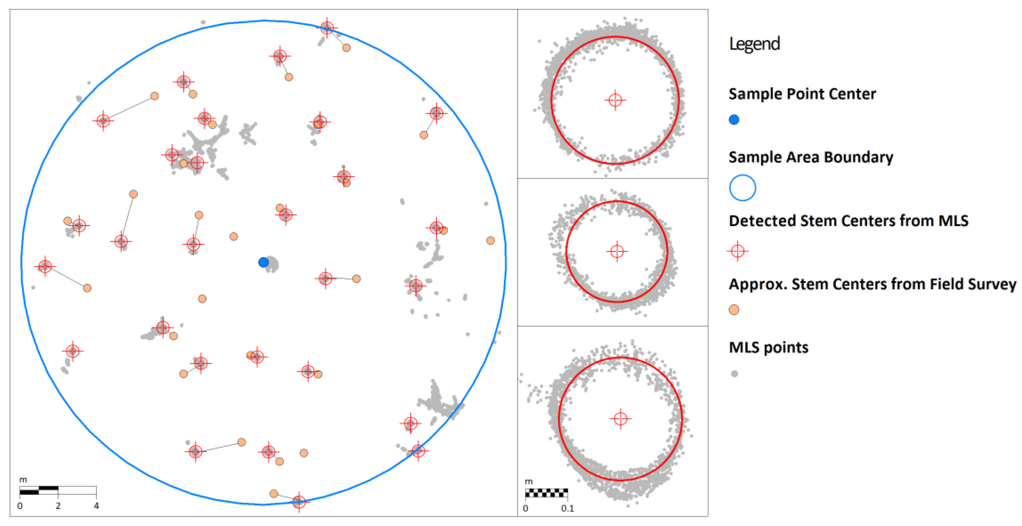
3.2. Mobile Laser Scanning
3.3. UAV Photogrammetry
3.4. UAV-Borne Laser Scanning
3.5. Aerial Laser Scanning with Light Aircraft
3.6. Comparison of the Results
4. Conclusions
Author Contributions
Funding
Data Availability Statement
Acknowledgments
Conflicts of Interest
Abbreviations
| TLS | Terrestrial Laser Scanning |
| MLS | Mobil Laser Scanning |
| UAV | Unmanned Aerial Vehicle (drone) |
| ULS | UAV-based Laser Scanning |
| SLAM | Simultaneous Localization and Mapping |
| DBH | Diameter at Breast Height |
| SfM | Structure-from-Motion |
| LiDAR | Light Detection and Ranging |
| RMSE | Root Mean Square Error |
References
- Szász, B.; Heil, B.; Kovács, G.; Heilig, D.; Veperdi, G.; Mészáros, D.; Illés, G.; Czimber, K. Investigation of the Relationship between Topographic and Forest Stand Characteristics Using Aerial Laser Scanning and Field Survey Data. Forests 2024, 15, 1546. [Google Scholar] [CrossRef]
- Czimber, K.; Szász, B.; Ács, N.; Heilig, D.; Illés, G.; Mészáros, D.; Veperdi, G.; Heil, B.; Kovács, G. Estimation of the Total Carbon Stock of Dudles Forest Based on Satellite Imagery, Airborne Laser Scanning, and Field Surveys. Forests 2025, 16, 512. [Google Scholar] [CrossRef]
- Coops, N.C.; Irwin, L.A.; Seely, H.S.; Hardy, S.J. Advances in Laser Scanning to Assess Carbon in Forests: From Ground-Based to Space-Based Sensors. Curr. For. Rep. 2025, 11, 11. [Google Scholar] [CrossRef]
- Conti, A.; Pagliaricci, G.; Bonora, V.; Tucci, G. A comparison between Terrestrial Laser Scanning and Hand-held Mobile Mapping for the Documentation of Built Heritage. Int. Arch. Photogramm. Remote Sens. Spatial Inf. Sci. 2024, 48, 141–147. [Google Scholar] [CrossRef]
- Liang, X.; Hyyppä, J.; Kaartinen, H.; Lehtomäki, M.; Pyörälä, J.; Pfeifer, N.; Holopainen, M.; Brolly, G.; Francesco, P.; Hackenberg, J.; et al. International benchmarking of terrestrial laser scanning approaches for forest inventories. ISPRS J. Photogramm. Remote Sens. 2018, 144, 137–179. [Google Scholar] [CrossRef]
- Wardius, Y.; Hein, S. Terrestrial laser scanning vs. manual methods for assessing complex forest stand structure: A comparative analysis on plenter forests. Eur. J. Forest Res. 2024, 143, 635–649. [Google Scholar] [CrossRef]
- Brolly, G.; Király, G.; Lehtomäki, M.; Liang, X. Voxel-Based Automatic Tree Detection and Parameter Retrieval from Terrestrial Laser Scans for Plot-Wise Forest Inventory. Remote Sens. 2021, 13, 542. [Google Scholar] [CrossRef]
- Brolly, G.; Király, G. Means of Terrestrial Laser Scanning. Acta Silv. Lignaria Hung. 2009, 5, 119–130. [Google Scholar] [CrossRef]
- Brolly, G.; Király, G.; Czimber, K. Mapping Forest Regeneration from Terrestrial Laser Scans. Acta Silv. Lignaria Hung. 2013, 9, 135–146. [Google Scholar] [CrossRef]
- Compeán-Aguirre, J.L.; López-Serrano, P.M.; Silván-Cárdenas, J.L.; Martínez-García-Moreno, C.A.; Vega-Nieva, D.J.; Corral-Rivas, J.J.; Pompa-García, M. Evaluation of Two-Dimensional DBH Estimation Algorithms Using TLS. Forests 2024, 15, 1964. [Google Scholar] [CrossRef]
- You, L.; Sun, Y.; Liu, Y.; Chang, X.; Jiang, J.; Feng, Y.; Song, X. Tree Skeletonization with DBSCAN Clustering Using Terrestrial Laser Scanning Data. Forests 2023, 14, 1525. [Google Scholar] [CrossRef]
- Capalb, F.; Apostol, B.; Lorenț, A.; Petrila, M.; Marcu, C.; Badea, N.O. Integration of Terrestrial Laser Scanning and field measurements data for tree stem volume estimation: Exploring parametric and non-parametric modeling approaches. Ann. For. Res. 2024, 67, 77–94. [Google Scholar] [CrossRef]
- Yang, W.; Wilkes, P.; Vicari, M.B.; Hand, K.; Calders, K.; Disney, M. Treegraph: Tree Architecture from Terrestrial Laser Scanning Point Clouds. Remote Sens. Ecol. Conserv. 2024, 10, 755–774. [Google Scholar] [CrossRef]
- Åkerblom, M.; Raumonen, P.; Mäkipää, R.; Kaasalainen, M. Automatic tree species recognition with quantitative structure models. Remote Sens. Environ. 2017, 191, 1–12. [Google Scholar] [CrossRef]
- Brede, B.; Calders, K.; Lau, A.; Raumonen, P.; Bartholomeus, H.M.; Herold, M.; Kooistra, L. Non-destructive tree volume estimation through quantitative structure modelling: Comparing UAV laser scanning with terrestrial LIDAR. Remote Sens. Environ. 2019, 233, 111355. [Google Scholar] [CrossRef]
- Markku, Å.; Raumonen, P.; Kaasalainen, M.; Casella, E. Analysis of Geometric Primitives in Quantitative Structure Models of Tree Stems. Remote Sens. 2015, 7, 4581–4603. [Google Scholar] [CrossRef]
- Meng, Y.; Dong, X.; Han, K.; Liu, H.; Qu, H.; Gao, T. Classification of Tree Species Using Point Cloud Features from Terrestrial Laser Scanning. Forests 2024, 15, 2110. [Google Scholar] [CrossRef]
- Chen, P.; Zhao, X.; Zeng, L.; Liu, L.; Liu, S.; Sun, L.; Li, Z.; Chen, H.; Liu, G.; Qiao, Z.; et al. A Review of Research on SLAM Technology Based on the Fusion of LiDAR and Vision. Sensors 2025, 25, 1447. [Google Scholar] [CrossRef]
- Pan, D.; Shao, J.; Zhang, S.; Zhang, S.; Chang, B.; Xiong, H.; Zhang, W. SLAM-Based Forest Plot Mapping by Integrating IMU and Self-Calibrated Dual 3-D Laser Scanners. IEEE Trans. Geosci. Remote Sens. 2023, 61, 1–13. [Google Scholar] [CrossRef]
- Spadavecchia, C.; Belcore, E.; Grasso, N.; Piras, M. A fully automatic forest paramteres extraction at single-tree level: A comparison of MLS and TLS applications. Int. Arch. Photogramm. Remote Sens. Spatial Inf. Sci. 2023, 48, 457–463. [Google Scholar] [CrossRef]
- Krisanski, S.; Taskhiri, M.S.; Gonzalez Aracil, S.; Herries, D.; Muneri, A.; Gurung, M.B.; Montgomery, J.; Turner, P. Forest Structural Complexity Tool—An Open Source, Fully-Automated Tool for Measuring Forest Point Clouds. Remote Sens. 2021, 13, 4677. [Google Scholar] [CrossRef]
- Faitli, T.; Hyyppä, E.; Hyyti, H.; Hakala, T.; Kaartinen, H.; Kukko, A.; Muhojoki, J.; Hyyppä, J. Integration of a Mobile Laser Scanning System with a Forest Harvester for Accurate Localization and Tree Stem Measurements. Remote Sens. 2024, 16, 3292. [Google Scholar] [CrossRef]
- Woltring, H.J.; Huiskes, R. Stereophotogrammetry. In Biomechanics of Human Movement: Applications in Rehabilitation, Sport and Ergonomics; Bertec: Columbus, OH, USA, 1990; pp. 108–127. Available online: https://pure.tue.nl/ws/portalfiles/portal/2808839/585701.pdf (accessed on 6 April 2025).
- Karami, E.; Prasad, S.; Shehata, M. Image Matching Using SIFT, SURF, BRIEF and ORB: Performance Comparison for Distorted Images. In Proceedings of the 2015 Newfoundland Electrical and Computer Engineering Conference, St. Johns, NS, Canada, 3–6 May 2015. [Google Scholar] [CrossRef]
- Hirschmuller, H. Accurate and efficient stereo processing by semi-global matching and mutual information. IEEE Comput. Soc. Conf. Comput. Vis. Pattern Recognit. 2005, 2, 807–814. [Google Scholar] [CrossRef]
- Furukawa, Y.; Hernández, C. Multi-View Stereo: A Tutorial. Found. Trends Comput. Graph. Vis. 2015, 9, 1–148. [Google Scholar] [CrossRef]
- Westoby, M.J.; Brasington, J.; Glasser, N.F.; Hambrey, M.J.; Reynolds, J.M. ‘Structure-from-Motion’ photogrammetry: A low-cost, effective tool for geoscience applications. Geomorphology 2012, 179, 300–314. [Google Scholar] [CrossRef]
- Iglhaut, J.; Cabo, C.; Puliti, S.; Piermattei, L.; O’Connor, J.; Rosette, J. Structure from Motion Photogrammetry in Forestry: A Review. Curr. For. Rep. 2019, 5, 155–168. [Google Scholar] [CrossRef]
- Verhoeven, G.; Doneus, M.; Briese, C.; Vermeulen, F. Mapping by matching: A computer vision-based approach to fast and accurate georeferencing of archaeological aerial photographs. J. Archaeol. Sci. 2012, 39, 2060–2070. [Google Scholar] [CrossRef]
- Mielcarek, M.; Kamińska, A.; Stereńczak, K. Digital Aerial Photogrammetry (DAP) and Airborne Laser Scanning (ALS) as Sources of Information about Tree Height: Comparisons of the Accuracy of Remote Sensing Methods for Tree Height Estimation. Remote Sens. 2020, 12, 1808. [Google Scholar] [CrossRef]
- Krause, S.; Sanders, T.G.M.; Mund, J.-P.; Greve, K. UAV-Based Photogrammetric Tree Height Measurement for Intensive Forest Monitoring. Remote Sens. 2019, 11, 758. [Google Scholar] [CrossRef]
- Panagiotidis, D.; Abdollahnejad, A.; Surový, P.; Chiteculo, V. Determining tree height and crown diameter from high-resolution UAV imagery. Int. J. Remote Sens. 2016, 38, 2392–2410. [Google Scholar] [CrossRef]
- Bohlin, J.; Wallerman, J.; Fransson, J.E.S. Forest variable estimation using photogrammetric matching of digital aerial images in combination with a high-resolution DEM. Scand. J. For. Res. 2012, 27, 692–699. [Google Scholar] [CrossRef]
- Balenović, I.; Marjanović, H.; Indir, K.; Vuletić, D.; Ostrogovic, Z.M.; Benko, M. Estimation of the stands’ arithmetic mean diameter using manual method of digital photogrammetry. Period. Biol. 2013, 115, 399–407. [Google Scholar]
- Cao, L.; Liu, H.; Fu, X.; Zhang, Z.; Shen, X.; Ruan, H. Comparison of UAV LiDAR and Digital Aerial Photogrammetry Point Clouds for Estimating Forest Structural Attributes in Subtropical Planted Forests. Forests 2019, 10, 145. [Google Scholar] [CrossRef]
- Mao, Z.; Lu, Z.; Wu, Y.; Deng, L. DBH Estimation for Individual Tree: Two-Dimensional Images or Three-Dimensional Point Clouds? Remote Sens. 2023, 15, 4116. [Google Scholar] [CrossRef]
- Bruggisser, M.; Hollaus, M.; Kükenbrink, D.; Pfeifer, N. Comparison of forest structure metrics derived from UAV LiDAR and ALS data. ISPRS Ann. Photogramm. Remote Sens. Spat. Inf. Sci. 2019, 4, 325–332. [Google Scholar] [CrossRef]
- Kraus, K.; Pfeifer, N. A new method for surface reconstruction from laser scanner data. Int. Arch. Photogramm. Remote Sens. 1997, 32, 80–86. [Google Scholar]
- Li, F.; Zhu, H.; Luo, Z.; Shen, H.; Li, L. An Adaptive Surface Interpolation Filter Using Cloth Simulation and Relief Amplitude for Airborne Laser Scanning Data. Remote Sens. 2021, 13, 2938. [Google Scholar] [CrossRef]
- Cai, S.; Zhang, W.; Liang, X.; Wan, P.; Qi, J.; Yu, S.; Yan, G.; Shao, J. Filtering Airborne LiDAR Data Through Complementary Cloth Simulation and Progressive TIN Densification Filters. Remote Sens. 2019, 11, 1037. [Google Scholar] [CrossRef]
- Dong, Y.; Cui, X.; Zhang, L.; Ai, H. An Improved Progressive TIN Densification Filtering Method Considering the Density and Standard Variance of Point Clouds. ISPRS Int. J. Geo-Inf. 2018, 7, 409. [Google Scholar] [CrossRef]
- Axelsson, P. DEM Generation from Laser Scanner Data Using Adaptive TIN Models. ISPRS—Int. Arch. Photogramm. Remote Sens. Spat. Inf. Sci. 2000, 33, 110–117. [Google Scholar]
- Pingel, T.J.; Clarke, K.C.; McBride, W.A. An Improved Simple Morphological Filter for the Terrain Classification of AirborneLIDAR Data. ISPRS J. Photogramm. Remote Sens. 2013, 77, 21–30. [Google Scholar] [CrossRef]
- Zhang, K.; Chen, S.-C.; Whitman, D.; Shyu, M.-L.; Yan, J.; Zhang, C. A Progressive Morphological Filter for Removing Nonground Measurements from Airborne LIDAR Data. IEEE Trans. Geosci. Remote Sens. 2003, 41, 872–882. [Google Scholar] [CrossRef]
- Lee, H.; Slatton, K.C.; Roth, B.E.; Cropper JR, W.P. Adaptive Clustering of Airborne LiDAR Data to Segment Individual Tree Crowns in Managed Pine Forests. Int. J. Remote Sens. 2010, 31, 117–139. [Google Scholar] [CrossRef]
- Ayrey, E.; Fraver, S.; Kershaw, J.A., Jr.; Kenefic, L.S.; Hayes, D.; Weiskittel, A.R.; Roth, B.E. Layer Stacking: A Novel Algorithm for Individual Forest Tree Segmentation from LiDAR Point Clouds. Can. J. Remote Sens. 2017, 43, 16–27. [Google Scholar] [CrossRef]
- Strîmbu, V.F.; Strîmbu, B.M. A Graph-Based Segmentation Algorithm for Tree Crown Extraction Using Airborne LiDAR Data. ISPRS J. Photogramm. Remote Sens. 2015, 104, 30–43. [Google Scholar] [CrossRef]
- White, J.C.; Wulder, M.A.; Buckmaster, G. Validating Estimates of Merchantable Volume from Airborne Laser Scanning (ALS)Data Using Weight Scale Data. For. Chron. 2014, 90, 378–385. [Google Scholar] [CrossRef]
- Oehmcke, S.; Li, L.; Revenga, J.C.; Nord-Larsen, T.; Trepekli, K.; Gieseke, F.; Igel, C. Deep Learning Based 3D Point CloudRegression for Estimating Forest Biomass. In Proceedings of the 30th International Conference on Advances in GeographicInformation Systems, Seattle, WA, USA, 1–4 November 2022; Association for Computing Machinery: New York, NY, USA, 2022; pp. 1–4. [Google Scholar]
- Ullah, S.; Dees, M.; Datta, P.; Adler, P.; Koch, B. Comparing Airborne Laser Scanning, and Image-Based Point Clouds by Semi-Global Matching and Enhanced Automatic Terrain Extraction to Estimate Forest Timber Volume. Forests 2017, 8, 215. [Google Scholar] [CrossRef]
- Sačkov, I.; Bucha, T.; Király, G.; Brolly, G.; Raši, R. Individual tree and crown identification in the Danube floodplain forests based on airborne laser scanning data. In Proceedings of the EARSeL 34th Symposium Proceedings, Warsaw, Poland, 16–20 June 2014; pp. 16–20. [Google Scholar] [CrossRef]
- Kuželka, K.; Slavík, M.; Surový, P. Very High Density Point Clouds from UAV Laser Scanning for Automatic Tree Stem Detection and Direct Diameter Measurement. Remote Sens. 2020, 12, 1236. [Google Scholar] [CrossRef]
- Hao, Y.; Widagdo, F.R.A.; Liu, X.; Quan, Y.; Dong, L.; Li, F. Individual Tree Diameter Estimation in Small-Scale Forest Inventory Using UAV Laser Scanning. Remote Sens. 2021, 13, 24. [Google Scholar] [CrossRef]
- Chisholm, R.A.; Rodríguez-Ronderos, M.E.; Lin, F. Estimating Tree Diameters from an Autonomous Below-Canopy UAV with Mounted LiDAR. Remote Sens. 2021, 13, 2576. [Google Scholar] [CrossRef]


| Sampling Point | Number of Stems | Average DBH [cm] | Average Height [m] | Total Volume [m3] |
|---|---|---|---|---|
| 19I | 27 | 25.4 | 17.7 | 15.3 |
| 19J | 21 | 29.2 | 20.1 | 16.5 |
| 20I | 49 | 19.7 | 12.1 | 9.4 |
| 20J | 36 | 18.5 | 15.9 | 10.8 |
| Sampling Point | Number of Stems | Average DBH [cm] | Average Height [m] | |||||
|---|---|---|---|---|---|---|---|---|
| MLS | ALS | MLS | ALS | RMSE | MLS | ALS | RMSE | |
| 19I | 27 | 32 | 25.0 | 20.6 | 5.5 | 20.3 | 18.8 | 1.3 |
| 19J | 21 | 30 | 29.2 | 23.0 | 5.5 | 22.5 | 20.7 | 1.6 |
| 20I | 42 | 54 | 18.7 | 18.2 | 5.2 | 14.0 | 13.8 | 1.5 |
| 20J | 36 | 43 | 19.4 | 19.4 | 7.8 | 18.1 | 17.6 | 3.0 |
| Sampling Point | Hit Rate [%] | DBH RMSE [cm] | Height RMSE [m] | |||||||
|---|---|---|---|---|---|---|---|---|---|---|
| MLS | ULS | Phot. | ALS | MLS | Phot. | ALS | ULS | Phot. | ALS | |
| 19I | 100 | 96.2 | 84.6 | 100 | 1.0 | 2.3 | 5.4 | 0.7 | 0.7 | 1.3 |
| 19J | 100 | 66.7 | 81.0 | 95.2 | 1.0 | 2.6 | 5.5 | 0.5 | 0.7 | 1.6 |
| 20I | 83.7 | 69.4 | 67.3 | 73.5 | 2.7 | 2.7 | 6.0 | 3.0 | 1.7 | 1.5 |
| 20J | 83.3 | 38.9 | 50.0 | 66.7 | 1.5 | 2.6 | 7.7 | 3.4 | 3.4 | 3.0 |
| Merged | 89.4 | 65.9 | 68.2 | 80.3 | 1.9 | 2.5 | 6.2 | 2.2 | 1.9 | 1.9 |
| Tree Number | Field Survey | MLS | ULS | Photogrammetry | ALS | ||||
|---|---|---|---|---|---|---|---|---|---|
| d [cm] | h [m] | d [cm] | h [m] | h [m] | d [cm] | h [m] | d [cm] | h [m] | |
| 1 | 45.8 | 21.8 | 45.1 | 21.7 | 22.1 | 42 | 22.3 | 36.5 | 20.9 |
| 2 | 35.9 | 22.2 | 36.2 | 21.8 | 21.8 | 33 | 22.1 | 27.2 | 21.1 |
| 3 | 27.1 | 22.0 | 26.7 | 21.9 | 20.8 | 20.6 | |||
| 4 | 24.3 | 19.0 | 24.3 | 22.6 | 22.7 | 22 | 23.1 | 30.2 | 18.6 |
| 5 | 27.0 | 18.0 | 26.7 | 21.6 | 21.6 | 23 | 22 | 23.8 | 20.8 |
| 6 | 37.3 | 20.0 | 37.2 | 23.7 | 23.8 | 34 | 24.1 | 37.7 | 23.2 |
| 7 | 32.2 | 21.1 | 31.1 | 23.3 | 22.2 | 28 | 22.8 | 36.0 | 21.2 |
| 8 | 18.5 | 17.6 | 18.0 | 23.8 | 19 | 24.4 | |||
| 9 | 30.2 | 20.8 | 29.9 | 23.4 | 24.5 | 37.7 | 23.5 | ||
| 10 | 32.2 | 22.2 | 29.4 | 23.7 | 24.5 | 28 | 24.4 | 25.0 | 23.2 |
| 11 | 31.3 | 22.8 | 30.3 | 21.4 | 21.4 | 32 | 23 | 31.2 | 19.6 |
| 12 | 29.1 | 21.0 | 29.2 | 23.6 | 22.9 | 27 | 23.4 | 21.3 | 21.8 |
| 13 | 28.4 | 20.9 | 29.9 | 21.4 | 21.5 | 28 | 21.5 | 26.4 | 20.4 |
| 14 | 29.3 | 22.2 | 29.2 | 22.0 | 21.8 | 21.5 | 19.5 | ||
| 15 | 29.2 | 23.6 | 29.8 | 21.3 | 31 | 22.7 | 26.4 | 20.6 | |
| 16 | 28.3 | 18.6 | 30.0 | 22.6 | 27 | 22.4 | 24.7 | 21.5 | |
| 17 | 19.0 | 12.2 | 20.2 | 21 | 17.4 | 19.7 | |||
| 18 | 23.5 | 18.4 | 23.5 | 23.6 | 23.3 | 21 | 23.6 | 19.5 | 21.4 |
| 19 | 24.5 | 17.6 | 23.5 | 22.5 | 19.9 | 25 | 22.4 | 23.1 | 21.4 |
| 20 | 25.7 | 18.0 | 25.4 | 22.0 | 24 | 23.2 | 22.3 | 19.6 | |
| 21 | 34.1 | 22.1 | 35.0 | 23.9 | 24.1 | 36 | 24.2 | 27.0 | 23 |
| Mean | 29.2 | 20.1 | 29.1 | 22.5 | 22.7 | 28.2 | 23.0 | 26.8 | 21.1 |
Disclaimer/Publisher’s Note: The statements, opinions and data contained in all publications are solely those of the individual author(s) and contributor(s) and not of MDPI and/or the editor(s). MDPI and/or the editor(s) disclaim responsibility for any injury to people or property resulting from any ideas, methods, instructions or products referred to in the content. |
© 2025 by the authors. Licensee MDPI, Basel, Switzerland. This article is an open access article distributed under the terms and conditions of the Creative Commons Attribution (CC BY) license (https://creativecommons.org/licenses/by/4.0/).
Share and Cite
Szász, B.; Heil, B.; Kovács, G.; Mészáros, D.; Czimber, K. Comparison of Advanced Terrestrial and Aerial Remote Sensing Methods for Above-Ground Carbon Stock Estimation—A Comparative Case Study for a Hungarian Temperate Forest. Remote Sens. 2025, 17, 2173. https://doi.org/10.3390/rs17132173
Szász B, Heil B, Kovács G, Mészáros D, Czimber K. Comparison of Advanced Terrestrial and Aerial Remote Sensing Methods for Above-Ground Carbon Stock Estimation—A Comparative Case Study for a Hungarian Temperate Forest. Remote Sensing. 2025; 17(13):2173. https://doi.org/10.3390/rs17132173
Chicago/Turabian StyleSzász, Botond, Bálint Heil, Gábor Kovács, Diána Mészáros, and Kornél Czimber. 2025. "Comparison of Advanced Terrestrial and Aerial Remote Sensing Methods for Above-Ground Carbon Stock Estimation—A Comparative Case Study for a Hungarian Temperate Forest" Remote Sensing 17, no. 13: 2173. https://doi.org/10.3390/rs17132173
APA StyleSzász, B., Heil, B., Kovács, G., Mészáros, D., & Czimber, K. (2025). Comparison of Advanced Terrestrial and Aerial Remote Sensing Methods for Above-Ground Carbon Stock Estimation—A Comparative Case Study for a Hungarian Temperate Forest. Remote Sensing, 17(13), 2173. https://doi.org/10.3390/rs17132173