Abstract
Canopy chlorophyll content (CCC) is a key indicator for assessing the carbon sequestration capacity and material cycling efficiency of ecosystems, and its accurate retrieval holds significant importance for analyzing ecosystem functioning. Although numerous destructive and remote sensing methods have been developed to estimate CCC, the accurate estimation of CCC remains a significant challenge in mountainous regions with complex terrain and heterogeneous vegetation types. Through the synergistic analysis of ground hyperspectral and Sentinel-2 data, this study employed Pearson correlation analysis and spectral resampling techniques to identify Sentinel-2 blue band B1 (443 nm) and red band B4 (665 nm) as chlorophyll-sensitive bands through spectral matching with the hyperspectral reflectance of typical grassland vegetation. Based on this, we developed a new four-band vegetation index (VI), the Dual Red-edge and Coastal Aerosol Vegetation Index (DRECAVI), for estimating the CCC of heterogeneous grasslands in the middle section of the Tianshan Mountains. DRECAVI incorporates red-edge anti-saturation modules (bands B4 and B7) and aerosol correction modules (bands B1 and B8). In order to test the performance of the new index, we compared it with eight commonly used indices and a hybrid model, the Sentinel-2 Biophysical Processor (S2BP). The results indicated the following: (1) DRECAVI demonstrated the highest accuracy in CCC retrieval for mountainous vegetation (R2 = 0.74, RMSE = 16.79, MAE = 12.50) compared to other VIs and hybrid methods, effectively mitigating saturation effects in high biomass areas and capturing a weak bimodal distribution pattern of CCC in the montane meadow. (2) The blue band B1 enhances atmospheric correction robustness by suppressing aerosol scattering, and the red-edge band B7 overcomes the sensitivity limitations of conventional red-edge indices (such as NDVI705, CIred-edge, and NDRE), demonstrating the potential application of the synergy mechanism between the blue band and the red-edge band. (3) Although the S2BP achieved high accuracy (R2 = 0.73, RMSE = 19.83, MAE = 14.71) without saturation effects and detected a bimodal distribution of CCC in the montane meadow of the study area, its algorithmic complexity hindered large-scale operational applications. In contrast, DRECAVI maintained similar precision while reducing algorithmic complexity, making it more suitable for regional-scale grassland dynamic monitoring. This study confirms that the synergistic use of multi-source data effectively overcomes the limitations of the spectral–spatial resolution of a single data source, providing a novel methodology for the precision monitoring of mountain ecosystems.
1. Introduction
Grasslands constitute a significant component of the Earth’s terrestrial ecosystems, accounting for about one-third of the global land area [1] and 70% of the global agricultural area [2]. In terms of biodiversity conservation, climate moderation, and land-based carbon sequestration, these ecosystems hold significant importance. Concurrently, grassland ecosystems are also among the most vulnerable ecosystems [3] and are highly vulnerable to environmental impacts [4]. In recent years, more than 49% of global grassland ecosystems have experienced degradation because of climate change and human activities [5], with a decline in grassland productivity and carrying capacity, as well as a loss of biodiversity. Hence, it is imperative that we pay more attention to these critical and vulnerable ecosystems [6] and monitor and assess the ecological consequences of environmental change, to promptly grasp the health, productivity, and nutrient status of grassland vegetation [7]. This will enable us to develop appropriate conservation measures promptly.
To understand the condition of vegetation and its response to environmental changes, it is necessary to conduct spatiotemporal monitoring of the biophysical parameters of the vegetation canopy [8]. At the ecosystem scale, the physiological responses of vegetation typically respond faster than their structural responses to environmental stressors [9]. Therefore, monitoring the physiological responses of vegetation may help us recognize the impact of environmental change more quickly. The biophysical parameters of the vegetation canopy mainly control the overall photosynthesis and physiological activities of plants [10]. Additionally, vegetation biophysical parameters are very important inputs for terrestrial ecosystem simulation models such as carbon cycle models and crop growth models [11]. Among the parameters being considered, chlorophyll is the most critical. Chlorophyll molecules are crucial components of the plant photosynthetic apparatus [12] and play a vital role in capturing and converting light energy for plant metabolism [13]. Chlorophyll is closely related to water availability. The lack of water in leaves can affect chlorophyll production and accelerate its degradation, leading to leaf yellowing and rapidly decreasing chlorophyll content [14], thus reducing photosynthetic capacity [15]. As a result, chlorophyll reflects the physiological condition and the efficiency of photosynthesis in plants [16]. It is also an important indicator of vegetation health and is widely used in growth monitoring, stress detection, and yield estimation [17].
Traditional methods of obtaining biophysical parameters of vegetation rely on field sampling and laboratory measurement [18], which struggle to meet the demands of extracting vegetation parameters in a large range, especially in heterogeneous surface areas. Advancements in remote sensing technology have enabled the monitoring and evaluation of vegetation physiology and its functions on a broad scale in both space and time [9,19]. The information contained in the vegetation spectra collected through remote sensing technology can help detect daily functional changes in plant biochemistry, photosynthesis, and other processes under environmental stress [20,21]. These methods and techniques can detect the impact of environmental stress in near real-time, even before any obvious symptoms appear in plants [22]. The common methods for estimating vegetation biophysical parameters using remote sensing technology are as follows: (1) empirical models, (2) physical models, and (3) hybrid models. Empirical models mainly utilize the different reflective characteristics determined by the biophysical parameters of the vegetation canopy and establish the regression relationship between these parameters and the remote sensing reflectance [7,23] or vegetation index (VI) [24] at the leaf or canopy scale through statistics, thereby estimating biophysical parameters of vegetation. Most of the methods focus on the spectral bands of visible light (VIS, 380–780 nm) and near-infrared (NIR, 780–1100 nm) and shortwave-infrared (SWIR, 1100–3000 nm) regions [20,25,26]. For example, the region where the reflection curve changes sharply between the red and NIR bands is defined as the red-edge band [27], which has been demonstrated to be highly sensitive to chlorophyll content [28]. Therefore, using a combination of the red-edge band with other different bands, such as the red and green bands, can improve the estimation accuracy of vegetation chlorophyll content [29,30,31]. The empirical method is simple and effective, but lacks universality [32]. Physical models, such as canopy radiative transfer models (RTMs) [33], can simulate the spectral characteristics of complex vegetation canopies, solar radiation, and acquisition angles. Then, they can describe the physical mechanism between vegetation biophysical parameters and canopy reflectance [34], and can invert the vegetation chlorophyll content [35,36]. The model parameters have clear physical meaning and robustness [33]. Among them, the most widely used is the PROSAIL model, which integrates the PROSPECT model [37] and the SAIL model [38]. This model typically simulates the reflectance spectra of many parameter combinations through a lookup table (LUT) and realizes the inversion of vegetation canopy parameters by matching the measured reflectance spectra [39,40]. However, its complexity leads to low computational efficiency, and large differences in the RTM parameters may result in ill-conditioned inversion results [41]. Hybrid models are a combination of physical models with statistical approaches. They employ RTMs to simulate the reflectance of the vegetation canopy, subsequently utilizing this simulated data to train either parametric or non-parametric models. Through this procedure, the biophysical features of the canopy and spectral data are related [42]. They combine the flexibility of empirical models with the generalization ability of physical models [19,43], which relatively alleviates the pathological problems existing in physical models, thereby enhancing the model’s accuracy and reliability [44]. The hybrid method is more complex than the empirical one, and its outcomes also depend on the quality of the RTM [43].
In the previous decades, although many destructive and remote sensing methods have been developed to estimate chlorophyll [24,26], the existing studies have mainly focused on precision agriculture with relatively homogeneous cover [42,45,46,47], or on forests [19,48]. Only a limited number of studies involve the inversion of the biological parameters of mountainous heterogeneous grasslands [49,50,51]. In natural grasslands with heterogeneous features, characteristics such as the spatial and temporal variations in leaf and canopy features of different plant species have a considerable and unpredictable impact on the whole spectral scattering [20]. In addition, as a large amount of vegetation is distributed in mountainous areas with complex terrain, the distribution of solar radiation on the mountain surface is distorted by the terrain. This results in reduced radiance values on shaded slopes and increased radiance values on sunlit slopes in optical remote sensing imagery. The changes in spectral information caused by terrain undulations seriously affect the extraction accuracy of mountain vegetation information [52,53], increasing the difficulty of chlorophyll inversion. Tsele et al. used the Sentinel-2 Level 2 Prototype Processor (SL2P) to retrieve biophysical parameters, including canopy chlorophyll content (CCC), in the heterogeneous savanna and grasslands of South Africa; the results were not ideal [17]. As a result, accurately estimating the chlorophyll of mountain grasslands at large scales remains a challenging task that requires a higher spatial and spectral resolution to capture the subtle variations in vegetation chlorophyll [54].
The recently launched European Space Agency’s (ESA) Sentinel-2 mission is equipped with a high-resolution multispectral imaging device, offering spatial resolutions from 10 m to 60 m and a 5-day revisit capability. These characteristics establish it as being highly suitable for retrieving vegetation biophysical parameters [49]. The data encompass three bands within the “red-edge” spectrum, which are crucial for accurately estimating the chlorophyll content [27,55]. However, limited by the low spectral resolution, multispectral remote sensing monitoring struggles to obtain detailed information on the chlorophyll changes in the different vegetation in grasslands. The development of hyperspectral remote sensing technology has provided new data sources for grassland ecological monitoring. Hyperspectral remote sensing can obtain hundreds or even thousands of continuous and fine spectra of the target, and can capture chlorophyll-sensitive features (such as red-edge, green peaks, and absorption valleys) [56], effectively compensating for the limitations and deficiencies of multispectral remote sensing [57]. Nevertheless, hyperspectral data are limited by spatial coverage and are difficult to apply directly to large-scale grassland monitoring. To meet the requirements for large-scale and high-precision integrated monitoring in mountainous grasslands, we can improve the identification accuracy of terrestrial vegetation information through the collaborative application of high-spatial-resolution and high-spectral-resolution data.
Therefore, this paper focused on the middle section of the Tianshan Mountains, which features complex terrain and diverse vegetation types, as the study area. Based on ground hyperspectral data and Sentinel-2 multispectral data, we proposed a new mountain VI model driven by spectral characteristics, namely the Dual Red-edge and Coastal Aerosol Vegetation Index (DRECAVI). The aim was to attempt to create a method that could quickly and accurately extract the CCC of mountain vegetation based only on the spectral characteristics of vegetation and the remote sensing image data, without the need for complex operations and calculations such as terrain correction. The specific research content involved the following: (1) screening out the sensitive bands that had a significant response to the change in chlorophyll content based on the correlation analysis between spectral reflectance and chlorophyll content; (2) performing convolution resampling on ground-measured hyperspectral data using the Sentinel-2 spectral response function, combined with band sensitivity analysis and feature optimization, to construct a new VI based on multi-band collaborative enhancement; and (3) validating the superiority of the new VI in noise suppression and chlorophyll sensitivity enhancement across a heterogeneous vegetation canopy through comparative analyses with classical VIs and hybrid methods.
2. Materials and Methods
2.1. Study Region
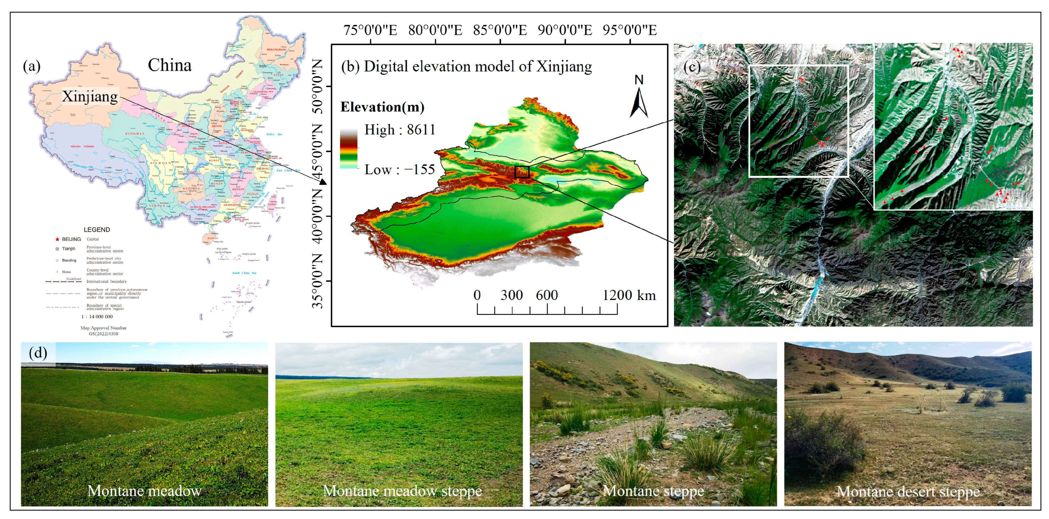
The Tianshan Mountain system, the largest mountain system in central Asia, is located in the arid and semi-arid region of Northwest China. It has a temperate continental arid climate. The natural landscape is rich and diverse, featuring glaciers, primeval forests, grasslands, and deserts, forming the most complete mountain vertical vegetation zone in the world’s temperate arid regions [58]. The study area is located in the central part of the northern slope of the Tianshan Mountains (Figure 1), with altitudes ranging from 1400 to 2400 m. The grassland types are primarily arranged from bottom to top as follows: montane desert steppe belt, montane steppe belt, montane meadow steppe belt, and montane meadow belt [58]. The spatial distribution of each grassland type is broadly parallel to the mountain contour lines, and within the same altitudinal zone, diverse compound structures of grassland types are formed. The climate characteristics and natural vegetation types in this region are well representative.
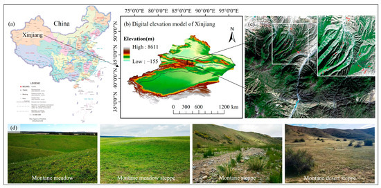
Figure 1.
Overview of the study area. (a) Location of Xinjiang; (b) digital elevation model of Xinjiang with 30 m resolution (the rectangular frame in the figure indicates the location of the study area); (c) the distribution map of sampling points set up along the altitude vertical zone in the middle section of the Tianshan Mountains; (d) the four main types of grassland in the study area.
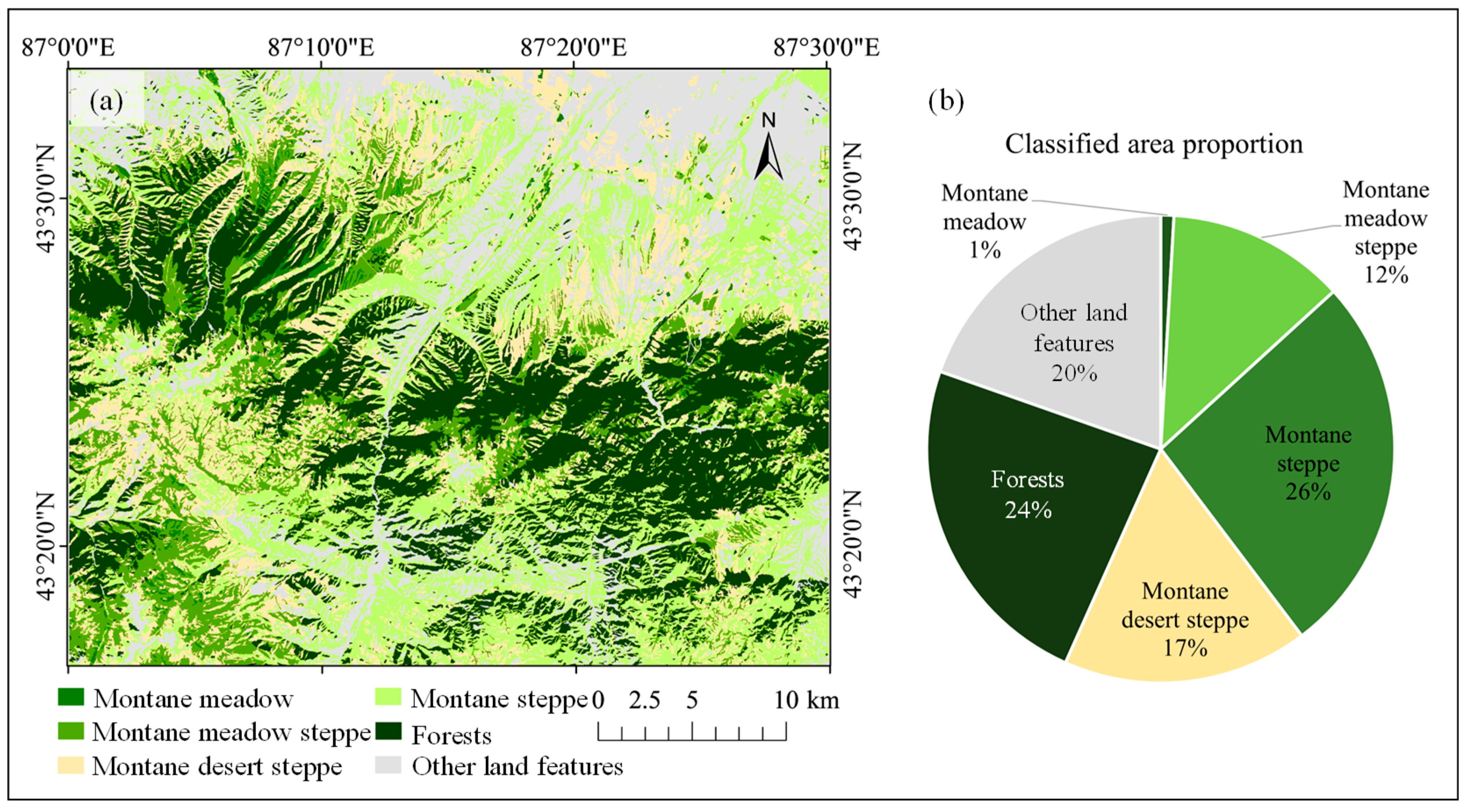
The land use classification of the study area and the information regarding the four grassland vegetation types mainly studied in this paper are shown in Figure 2. Among them, the area of montane steppe is the largest, accounting for 26%. The area of the montane meadow is the smallest, accounting for only 1%. The area of montane desert steppe accounts for 17%, and the area of montane meadow steppe accounts for 12%. The remainder consists of forests, settlements, bare land, and other features. The dominant plant families in this area are Asteraceae, Gramineae, Chenopodiaceae, and Leguminosae. The montane meadow is composed of mesophytic grasses and miscellaneous grasses, primarily including species such as awnless brome (Bromus inermis Leyss.) and Kentucky bluegrass (Poa pratensis L.). The montane meadow steppe is dominated by xerophytic and tufted grasses, with dominant species such as sheep fescue (Festuca ovina L.), needlegrass (Stipa capillata L.), and sedge (Carex turkestanica RgL.). The montane steppe is dominated by xerophytic grasses, followed by Artemisia sub-shrub and other xerophytic shrubs. In terms of the vegetation composition of the montane desert steppe, xerophilous tufted small grasses and xerophilous semi-shrubs are dominant [59].
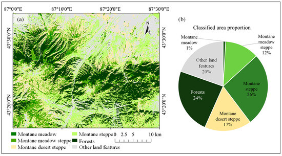
Figure 2.
(a) Land cover classification; (b) the area proportion of the four types of sampled grasslands and other land features.
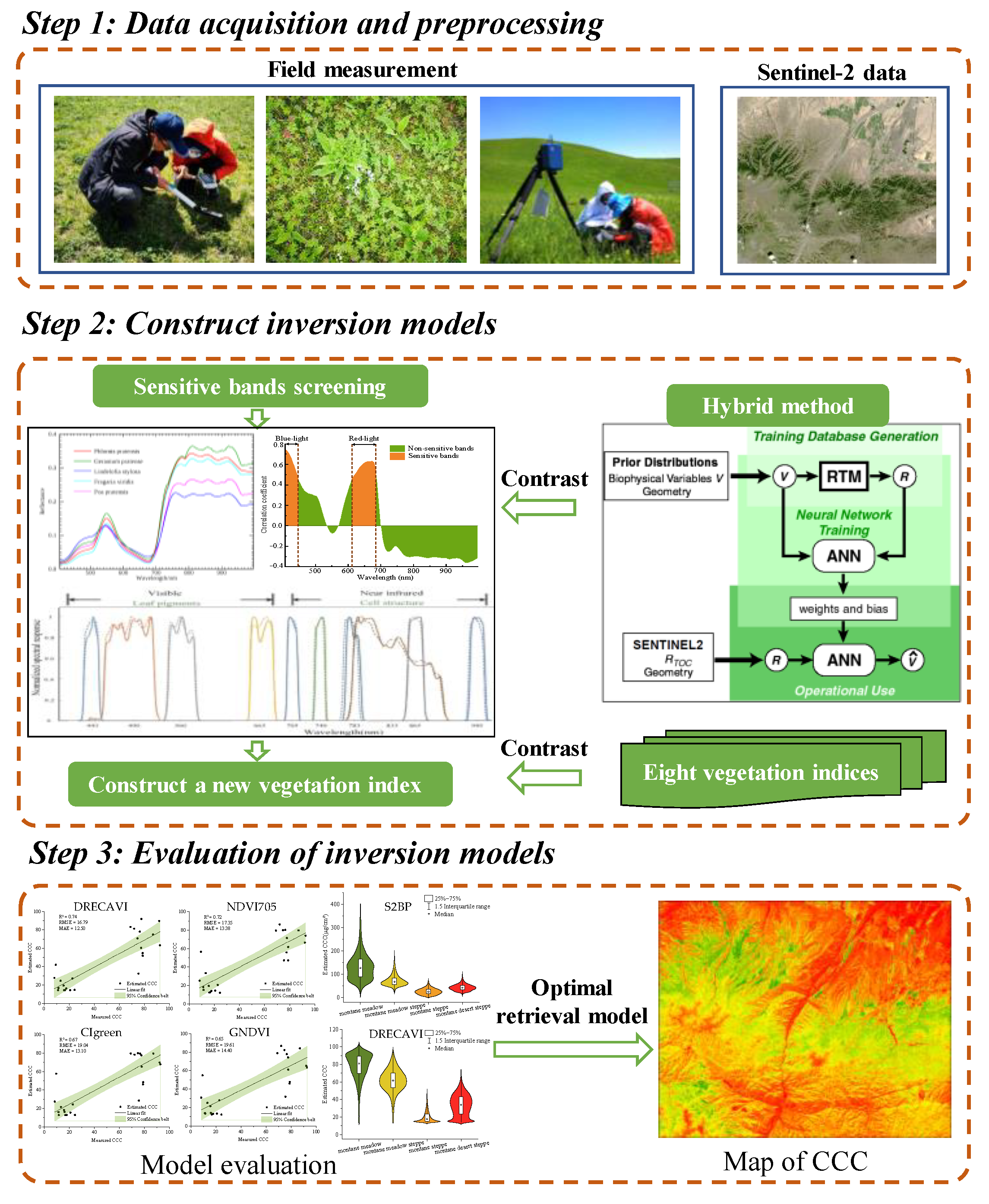
2.2. Schematic Workflow
The flowchart of the estimation method for grassland CCC in the heterogeneous natural environment of the Tianshan Mountains was established in this study (Figure 3). The following sections of this paper will explore these subjects in depth.
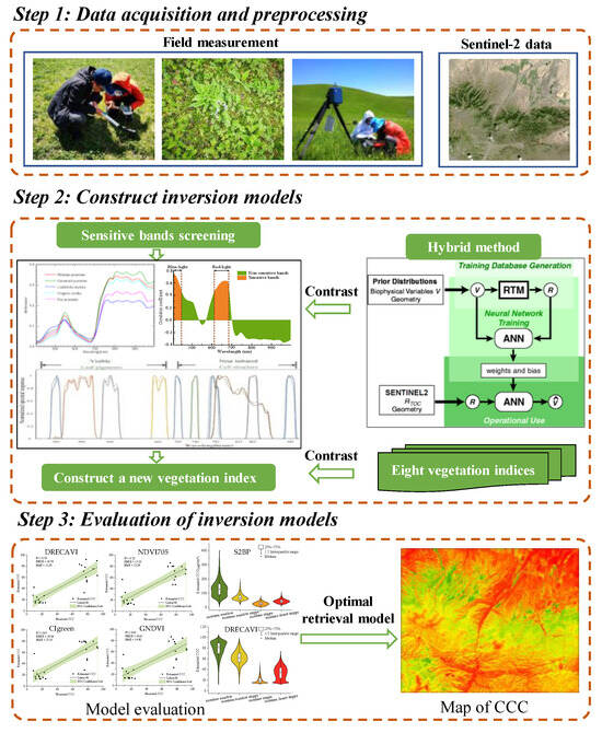
Figure 3.
The workflow of retrieving CCC in mountainous heterogeneous grasslands using ground hyperspectral and Sentinel-2 data (for hybrid model diagram, refer to [60]).
2.3. Field Measurements
2.3.1. Acquisition of CCC
Field data were collected in mid- to late June to match the overpass period of the Sentinel-2 satellite as closely as possible, with this period expected to have the most stable canopy chlorophyll levels (e.g., peak vegetation growing season). Due to constraints such as limited access to mountainous areas and weather conditions, field experimental data collection was constrained. Therefore, representative grassland types along the vertical zone in the study area were selected to establish points for investigation, and 4 grassland types were collected (Figure 1). The measuring points were preferably located in areas where the dominant grass species were representative and typical, and where the spatial distribution was uniform. For each grassland type, six 20 m × 20 m plots were established. Within each plot, four quadrats were randomly sampled: 1 m × 1 m quadrats for herbaceous vegetation and 5 m × 5 m quadrats for shrubs. Species composition was documented using field photographs. The leaf chlorophyll content (LCC) was measured using the handheld SPAD-502 Plus chlorophyll meter (Konica Minolta, Inc., Tokyo, Japan). This instrument can quickly and non-destructively determine the relative chlorophyll content of plant leaves in a natural environment [61]. The SPAD value is a dimensionless number ranging from 0 to 100. It has been demonstrated that the measured SPAD value has a good linear relationship with the chlorophyll content [61,62,63]. In each quadrat, we randomly selected five representative herbaceous or shrubby green leaves. After reading the values at 10 sites, avoiding the plant veins, we calculated the relative chlorophyll content of each plant using the robust statistical method (taking the mean after eliminating the extreme values). The average of these measurements was calculated as the SPAD value for each quadrat.
LCC and leaf area index (LAI) were multiplied to obtain the CCC [64]. Previous studies have shown that both LAI and SPAD measurements obtained from the ground are purely optical observations, like the CCC derived from satellite observations [65]. Furthermore, there is a scarcity of empirical calibration functions to convert the SPAD values of grassland plants into the LCC. As a result, this study employed a dimensionless method to characterize the CCC of ground vegetation (CCCfield) [65]:
CCCfield = SPAD × LAI
LAI measurements were conducted using the LAI-2200C Plant Canopy Analyzer (Li-Cor, Lincoln, NE, USA). Measurements were collected near sunrise or sunset, or on overcast days, to ensure nearly uniform sky illumination. Data were collected both above and below the grassland vegetation canopy at each sample point to compute the LAI. The specific operating procedures can be found in the operation manual for the LAI-2200C Plant Canopy Analyzer. For each sample quadrat, the four corners were selected as the measurement points. The LAI of each sample quadrat was calculated based on the data from all the measurement points within the quadrat. For each sample point, the LAI value was ascertained by computing the mean of the measurements taken across the four quadrats. The descriptive statistics of the SPAD, LAI, and CCCfield values of the four main grassland types observed from sample plots are summarized in Table 1.

Table 1.
Descriptive statistics of the measured physical and chemical parameters of the four main grassland types. S.D. is the standard deviation.
2.3.2. Ground-Measured Hyperspectral Data Acquisition and Processing
Hyperspectral data were collected using an SOC710VP hyperspectral imager (Surface Optics Corporation, San Diego, CA, USA) covering the 400–1000 nm at spectral range at 4.7 nm resolution with 128 spectral bands. The measurements were conducted on clear, cloudless days with good lighting conditions, between 12:00 and 14:00. During vegetation canopy spectral measurements, it was essential to ensure consistency between the spectral measurement sampling points and the chlorophyll content collection sites, while ensuring the vegetation exhibited typicality and representativeness. The sensor direction was perpendicular to the ground and 0.60 m away from the vegetation canopy. A total of thirty hyperspectral images were collected, and six of the highest quality images were selected as experimental samples. The dominant plants were mainly Phlomoides pratensis (Kar. & Kir.) Adylov, Kamelin & Makhm., Geranium pratense L., Lindelofia stylosa (Kar. & Kir.) Brand, Fragaria viridis Duch., and Poa pratensis L.
After acquiring the hyperspectral data, bands exhibiting obvious anomalies were removed, and the retained spectral range was 406–997 nm, comprising a total of 115 bands. First, the hyperspectral data were calibrated and converted into reflectance using the SRAnal710 software. Subsequently, noise reduction and spectral smoothing were applied through a Savitzky–Golay filter (S-G) [66]. The S-G filter is a filtering method based on local polynomial least-squares fitting in the time domain. Its main advantage is that it can filter out noise while preserving the shape and width of the signal, thereby retaining image details well. The calculation formula is as follows:
where Yj* is the function fitting value; Yj+i is the original data; N is the convolution number, numerically equal to the size of the smooth window (2m + 1); and Ci represents the weight of point i.
Then, the typical vegetation spectral library was established by constructing average spectral curves from regions of interest (ROIs), which were processed in ENVI 5.6 software.
2.4. Satellite Data Collection and Processing
The Sentinel-2 mission comprises two satellites, namely Sentinel-2A and Sentinel-2B, deployed in 2015 and 2017, that can provide data across 13 spectral bands, ranging from VIS and VNIR to SWIR [67], as shown in Table 2.
Table 2.
Resolution characteristics of the Sentinel-2 spectral bands.
The Sentinel-2 image was obtained from the Copernicus Data Space Ecosystem (https://dataspace.copernicus.eu/) on 21 June 2024, and the product level was L1C. After radiometric calibration and atmospheric correction, the original image was resampled to a 20 m resolution, and then the required remote sensing image data of the test area were obtained by a clipping operation.
2.5. Approach for Constructing a New VI
2.5.1. Determination of the Spectral Range Sensitive to Chlorophyll Content
We performed Pearson correlation analysis to identify the spectral regions (406–997 nm) most sensitive to foliar chlorophyll content (quantified as SPAD values). The Pearson correlation analysis can quickly assess the linear relationship between two variables by calculating the covariance of the variables divided by their standard deviations’ product [57], and it has a value range of [−1, +1]. Correlation coefficients between 0.1 and 0.3 indicate a weak correlation, values between 0.3 and 0.5 indicate a moderate correlation, and values greater than 0.5 indicate a strong correlation. The formula is as follows:
where Xi is reflectance at wavelength i; Yi represents the relative chlorophyll content; and are the sample means of reflectance and SPAD values, respectively; and n is the number of samples.
2.5.2. Hyperspectral Data Resampling
The ground-measured hyperspectral data are continuous spectra with a higher spectral resolution. Atmospherically corrected remote sensing data acquired by satellite sensors cannot be directly compared to ground-measured hyperspectral data. It is necessary to convert the ground-measured hyperspectral reflectance to the equivalent satellite band reflectance using the spectral response function. The conversion can be achieved using the following formula [68]:
where Rrs(bandi) is the equivalent remote sensing reflectance of the satellite’s i-band, λmin and λmax are the start and end wavelengths of the band, Rrs(λ) is the ground-measured hyperspectral reflectance, and SRF(λ) is the spectral response function of the satellite’s band. The SRF was obtained from ESA (https://sentinels.copernicus.eu/-/copernicus-sentinel-2c-spectral-response-functions) on 15 February 2025.
2.5.3. Generation of a Regression Model Between the New VI and CCC
A new VI was developed based on the chlorophyll-sensitive bands extracted from Sentinel-2 reflectance data resampled to match hyperspectral resolutions. Through band ratio optimization and multispectral combinations, this index demonstrated enhanced accuracy in chlorophyll retrieval for heterogeneous mountain grasslands while effectively mitigating mountainous terrain effects and saturation issues.
In this study, the ground sampling data (96 samples) were randomly divided into a training set (72 samples) and an independent test set (24 samples) at a 3:1 ratio. The CCC (dimensionless) served as the dependent variable, while the VIs were employed as independent variables to develop estimation models using the training set. To balance the simplicity and interpretability of the model, six regression models were employed for modeling, including linear, power, exponential, quadratic polynomial, cubic polynomial, and logarithmic functions.
2.6. Performance Comparison and Accuracy Assessment of Model Inversion
2.6.1. Commonly Used VIs for Comparative Analysis
To evaluate the performance of the new VI for estimating grassland CCC, eight established VIs were selected based on their alignment with Sentinel-2 bands and relevance to chlorophyll sensitivity or soil adjustment. These VIs included the widely used Normalized Difference Vegetation Index (NDVI) and two VIs derived from the NDVI: the Red-edge Normalized Difference Vegetation Index (NDVI705) and the Green Normalized Difference Vegetation Index (GNDVI). Given that the red-edge band, red band, and green band are recognized as sensitive to chlorophyll, the Green Chlorophyll Index (CIgreen) utilizing the green band, the Red-edge Chlorophyll Index (CIred-edge) and the Normalized Difference Red-edge Index (NDRE) based on the red-edge band were also included. To evaluate the inversion effect in desert grasslands with high proportions of bare soil, sparse vegetation, or low chlorophyll content in plants, the Modified Chlorophyll Absorption Ratio Index (MCARI) and the Modified Soil-Adjusted Vegetation Index (MSAVI) were selected. The specific formulas are shown in Table 3.
Table 3.
Eight commonly used VIs for comparative analysis. Red-edge band abbreviates as RE. The different spectral bands of Sentinel-2 are designated as B1, B2, B3, etc.
2.6.2. Hybrid Method Used for Comparative Analysis
The hybrid model employed in this study was the Sentinel-2 Biophysical Processor (S2BP) tool, integrated within the Sentinel Application Platform (SNAP) software v10.0 (http://step.esa.int/main/download/snap-download/, accessed on 7 August 2024). S2BP, developed by Weiss and Baret [60], is a hybrid retrieval method for vegetation biophysical variables that combines a physical model with an artificial neural network (ANN). It has three primary phases: the module employs the PROSAIL model to generate a training dataset, adjust the neural network (NN), and estimate biophysical variables [60]. The ANN architecture includes the input, hidden, and output layers. The input layer of 20 m resolution products is composed of 11 pieces of normalized input data. The hidden layer comprises five neurons with tangent sigmoid activation. One output layer has a linear transfer function, and the vegetation biophysical parameters are obtained by a backpropagation artificial neural network [42,60]. The training dataset is divided into two parts through a process of random selection: two-thirds for NN training and one-third for model validation and accuracy assessment. Further details about the method can be found in Weiss and Baret [60].
2.6.3. Accuracy Evaluation of Model Inversion
The performance and robustness of the inversion models were quantitatively assessed using the test set by calculating the coefficient of determination (R2), root mean square error (RMSE), and mean absolute error (MAE) [75]. The R2 is a value between 0 and 1 that measures the degree of fitting, with a value closer to 1 indicating a better model fit. Both the RMSE and the MAE are indicators that measure the deviation of simulated values from actual values; the smaller the value of the RMSE or MAE, the higher the accuracy of the model. R2 is a statistic that is a predictor of precision. They were calculated using the following methods:
where represents the observed values, represents the estimated values, represents the average observed values, and n denotes the number of samples.
To quantify the uncertainty of the model estimates, we also calculated the confidence intervals at the 95% level. Narrower confidence intervals represent more accurate estimates, while wider intervals represent greater uncertainty.
3. Results
3.1. Typical Vegetation Spectral Reflectance Curves and Their Correlation with Chlorophyll
The S-G filter was applied to smooth the hyperspectral images, and average spectral reflectance curves (ranging from 406 to 997 nm) were obtained for five typical plants, as shown in Figure 4a. Analysis revealed that while all species exhibited similar overall spectral trends, with reflectance values generally ranging from 0 to 0.4, distinct local spectral features emerged due to interspecific variations in biochemical composition and structural traits. Specifically, spectral differentiation among species predominantly manifested in the blue-valley (410–430 nm) and red-valley regions (660–700 nm), formed by strong chlorophyll absorption; the green peak at 550 nm, caused by chlorophyll reflection; the red-edge (700–750 nm); and the NIR structural reflectance region (750–950 nm).
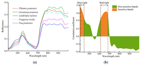
Figure 4.
(a) Average spectral reflectance curves (406–997 nm) of five typical plants; (b) correlation coefficient curve between spectral reflectance and chlorophyll content, where the orange-red areas indicate the range of the chlorophyll-sensitive bands.
Figure 4b illustrates the correlation coefficient curve between the spectral reflectance of five typical plants and the chlorophyll content. The orange-red areas indicate the range of the chlorophyll-sensitive bands, which are primarily concentrated in the blue-light region (407–446 nm) and the red-light region (612–684 nm), consistent with the findings of Jiang [76]. In the blue-valley region (407–431 nm), chlorophyll content showed an extremely significant positive correlation with spectral reflectance (P < 0.01), with correlation coefficients ranging from 0.61 to 0.75. In the 436–446 nm band, the two variables exhibited a significant positive correlation (P < 0.05), with correlation coefficients ranging from 0.48 to 0.57. In the red-light region around the 612–633 nm and 684 nm bands, chlorophyll content showed significant positive correlations with spectral reflectance (P < 0.05), with coefficients of 0.47–0.56 and 0.55, respectively. Similarly, in the 638–679 nm band, the correlation was extremely significant (P < 0.01), with correlation coefficients ranging from 0.58 to 0.63. The green-peak region exhibited a weak negative correlation with chlorophyll content. In the red-edge region, higher chlorophyll content enhanced red-light absorption, resulting in lower reflectance in the initial red-edge range (around 700 nm). Conversely, when chlorophyll content decreased, the reflectance increased [28]. Reflectance in this region showed a negative correlation with chlorophyll content, with correlation coefficients ranging from −0.21 to 0. It is generally believed that the reflectance in the NIR band is usually maintained at a high level, as chlorophyll’s influence diminishes significantly in this region, and no significant inverse correlation with chlorophyll content is observed. However, in this study, it was found that the NIR region (752–997 nm) showed a negative correlation with chlorophyll content, with coefficients ranging from −0.21 to −0.37. This pattern is likely attributed to the more compact cellular arrangement in high-chlorophyll leaves, which reduces NIR light-scattering paths and consequently lowers reflectance.
3.2. Hyperspectral Data Resampling and New VI Construction
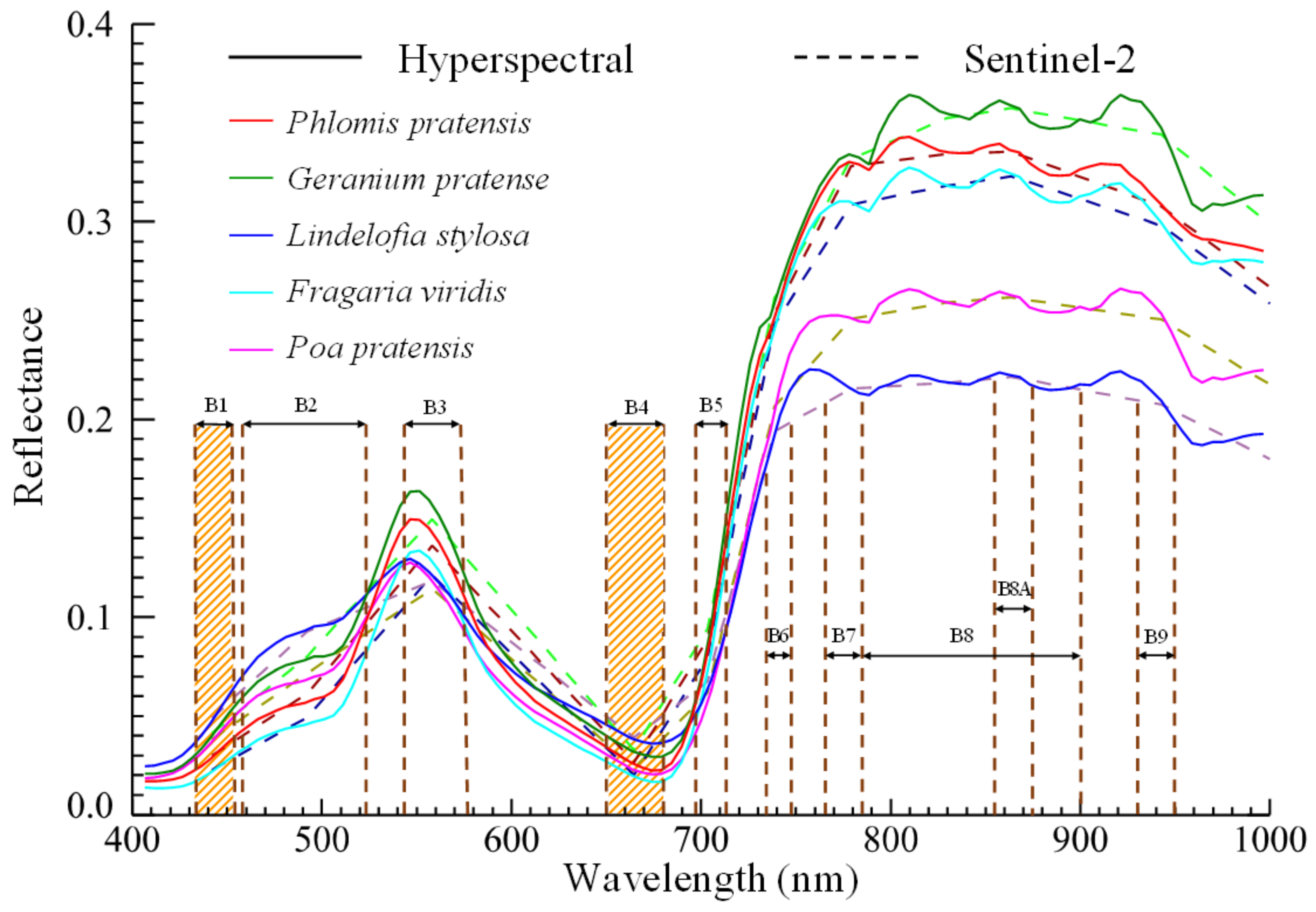
The ground-measured hyperspectral data of five typical plants were resampled using the spectral response function of Sentinel-2 (wavelength range: 400–1000 nm) to generate the equivalent remote sensing reflectance of the Sentinel-2 satellite bands, as shown in Figure 5. The resampled reflectance curves effectively retained the key spectral features of the original hyperspectral data, including the vegetation red-edge, absorption valleys, and reflectance peaks.
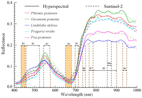
Figure 5.
Five typical plants’ ground-measured hyperspectral curves (solid lines) and the simulated Sentinel-2 reflectance curves (dashed lines). The orange-red striped areas indicate the ranges of chlorophyll-sensitive bands. The different spectral bands of Sentinel-2 are designated as B1, B2, B3, etc.
The band B1 of Sentinel-2 (central wavelength: 443 nm; spectral range: 433–453 nm) aligns closely with the chlorophyll-sensitive blue-light region (407–446 nm). The red valley in the Sentinel-2 reflectance spectrum has a slight blue shift compared to the ground-measured hyperspectral data. The 638–679 nm band (red-light) matches well with Sentinel-2 band B4 (central wavelength: 665 nm; spectral range: 650–680 nm). Band B4 of Sentinel-2 is well-known for its high sensitivity to chlorophyll, and its red-light spectral characteristics are closely correlated with vegetation photosynthetic activity. While Band B1 is primarily used for aerosol detection and is not typically applied in vegetation chlorophyll retrieval, its bandwidth is close to the blue-light region, which is more sensitive to chlorophyll. Carotenoids and xanthophylls in vegetation leaves have absorption characteristics in the blue-light band. Moreover, combining band B1 can correct for the atmospheric scattering of solar radiation on the surface in mountainous areas (such as the influence of aerosols) and reduce the impact of terrain [77]. Therefore, we initially selected bands B1 and B4 as the foundational bands for constructing the new VI.
Furthermore, incorporating additional spectral bands enhances the utilization of multi-band information and improves monitoring performance, as multi-band indices demonstrate superior robustness compared to dual-band indices [78]. Based on this, we introduced the red-edge band B7 (783 nm) and the NIR band B8 (842 nm) of Sentinel-2. Previous studies indicate that the red-edge region (700–780 nm) exhibits reduced sensitivity to vegetation type variations, effectively mitigating saturation issues in dense canopies [79]. Meanwhile, band B8 is highly responsive to canopy structural parameters and aids in suppressing noise from leaf thickness variations or background soil interference. Building upon these four bands (B1, B4, B7, B8), we constructed a new type of normalized index (DRECAVI). The calculation formula is as follows:
3.3. The Correlation Between VIs and CCC
Pearson correlation analysis was performed between CCC and both the newly developed VI and the reference VIs to assess their linear relationships. A higher correlation coefficient indicates a stronger linear association between a VI and CCC, suggesting that the VI may better capture the variations in CCC. All tested VIs demonstrated highly significant (P < 0.01) positive linear relationships with CCC (Table 4). For the newly constructed VI in this paper, the maximum correlation coefficient (R) was observed to be 0.84. Among the VIs used for comparison, the NDVI705 had the highest R value of 0.83, while MSAVI achieved the lowest R value of 0.60. This indicates that these VIs can effectively monitor the CCC.
Table 4.
Correlation coefficients between VIs and CCC.
3.4. Empirical Models for CCC Estimation
In this study, the measured CCC served as the dependent variable, while VIs were used as the independent variables. Six regression algorithms were employed to construct CCC estimation models. The optimal model was selected based on the highest R2 value (Table 5). The results demonstrated that most VIs exhibited quadratic or cubic relationships with CCC. Among all models, the regression model incorporating the DRECAVI as the independent variable achieved the best performance, with an R2 value of 0.75. The order of goodness of fit between the CCC and VIs was as follows: DRECAVI > NDVI705 > CIgreen > NDVI/GNDVI > NDRE > CIred-edge > MCARI > MSAVI.
Table 5.
Optimal CCC estimation models based on VIs.
3.5. Accuracy Evaluation of Empirical Models
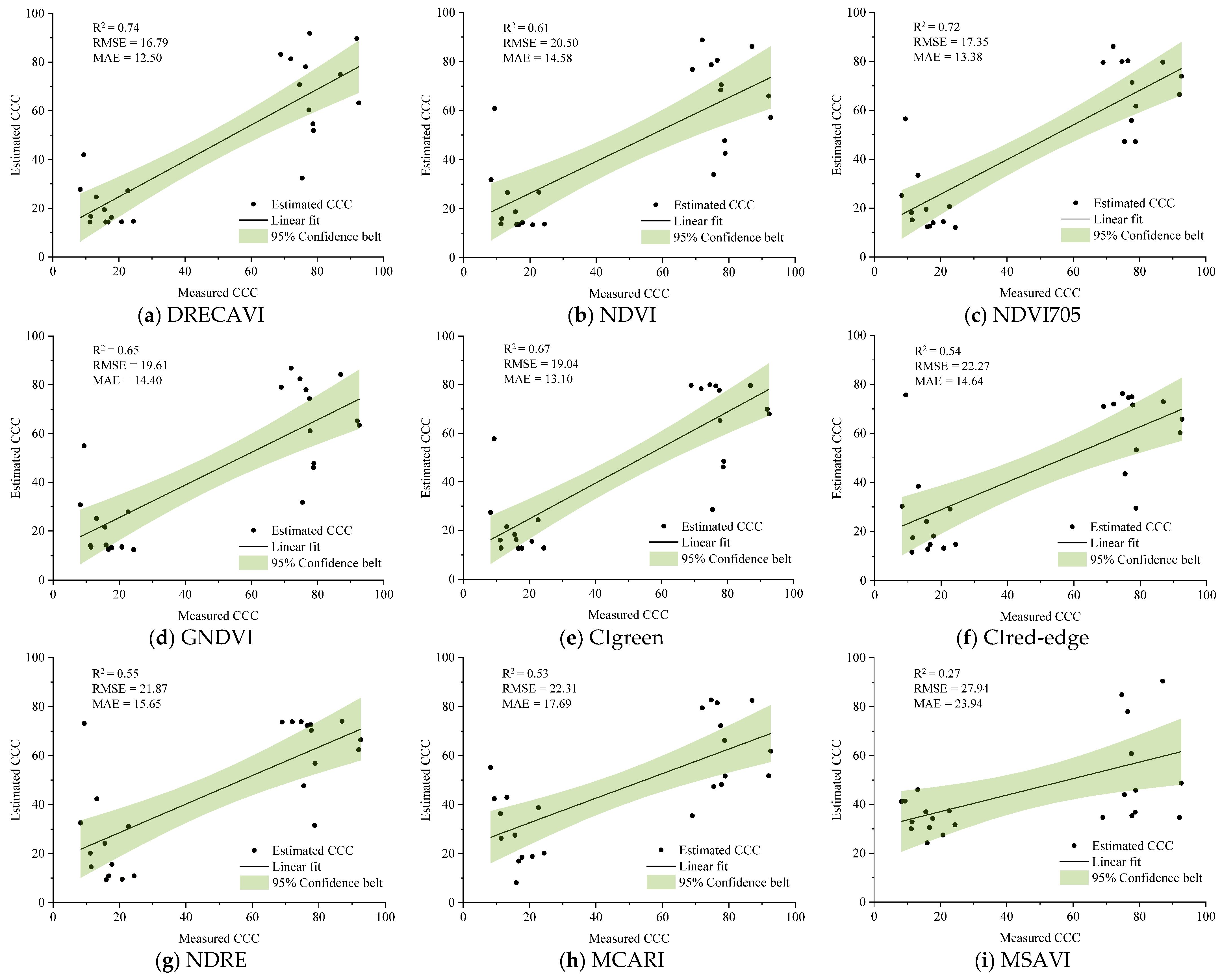
Linear regression analysis was conducted using nine VIs and a validation dataset comprising 24 samples. The estimation accuracy of each model was evaluated by calculating the R2, RMSE, and MAE values. The results are presented in Figure 6. Significant differences in estimation accuracy were observed among the VIs. The newly developed DRECAVI demonstrated superior performance, with the highest R2 value (0.74). This study encompassed four distinct grassland types, with measured SPAD values spanning a wide range (10.20–74.50). This substantial variability in chlorophyll content resulted in comparatively elevated RMSE and MAE values across the models. However, DRECAVI still achieved the lowest RMSE value (16.79) and the lowest MAE value (12.50). Among the VIs used for comparison, those based on the red-edge and green bands showed higher sensitivity to CCC in grassland vegetation. For example, NDVI705 (R2 = 0.72, RMSE = 17.35, MAE = 13.38), CIgreen (R2 = 0.67, RMSE = 19.04, MAE = 13.10), and GNDVI (R2 = 0.65, RMSE = 19.61, MAE = 14.40) all demonstrated good estimation performance.
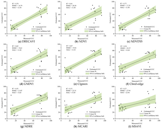
Figure 6.
Validation statistics of the CCC estimation models. Green areas indicate the 95% confidence belt.
Among the tested indices, two indices performed poorly in CCC estimation, including MCARI (R2 = 0.53, RMSE = 22.31, MAE = 17.69) and MSAVI (R2 = 0.27, RMSE = 27.94, MAE = 23.94). MCARI responds to leaf chlorophyll concentration and ground reflectance but shows weakness in predicting low chlorophyll concentrations, especially when influenced by soil signals [80]. Therefore, it is not suitable for heterogeneous environments with extensive bare ground, such as the Tianshan Mountains area. MSAVI demonstrated the lowest retrieval accuracy among all tested indices. This may be because MSAVI is most effective during the early stages of plant development [81], whereas our study focused on peak vegetation periods where canopy closure and chlorophyll saturation may reduce its sensitivity. Such a phenological mismatch could systematically bias CCC estimates.
3.6. Accuracy Evaluation of Hybrid Model
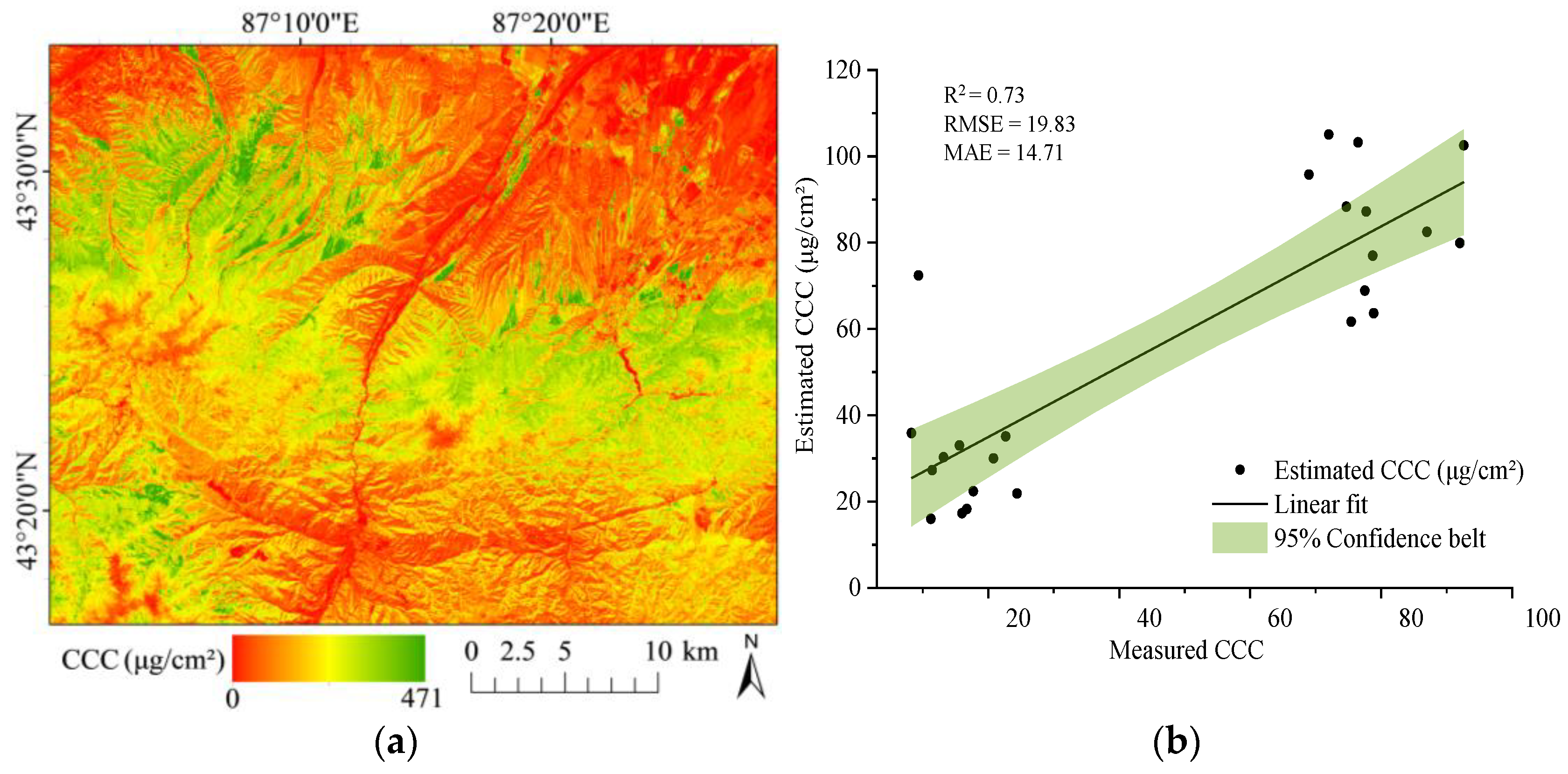
We used the S2BP from the SNAP to retrieve the CCC of different grassland vegetation types. The CCC spatial distribution map of the study region and its accuracy evaluation are presented in Figure 7. In this model inversion, the CCC in the study area ranges from 0 to 471.07 μg/cm2 (Figure 7a); the mean value is 43.38 μg/cm2 and the standard deviation is 31.37 μg/cm2. The standard deviation reflects the degree of dispersion among individuals within the group. The larger the value, the more dispersed the distribution of each observation, reflecting greater variability in the distribution of individual observations. Conversely, the smaller the value, the better the central tendency.

Figure 7.
(a) Remote sensing monitoring map of CCC; (b) accuracy evaluation of the hybrid model; green area indicates 95% confidence belt.
It is obvious that there is significant spatial variation in the CCC among different parts, and the chlorophyll content is quite different (Figure 7a). Areas with high CCC values are primarily found in montane meadow and montane meadow steppe at high altitudes, including forests such as the Schrenk spruce (Picea schrenkiana) forest that grows on shady slopes above 1400 m in altitude. In contrast, the montane desert steppe and the montane steppe at lower altitudes show low CCC values. After verifying the retrieval results with ground data, it was found that S2BP also had good CCC retrieval performance, with R2 = 0.73, RMSE = 19.83, and MAE = 14.71, as shown in Figure 7b.
3.7. Distribution Characteristics of CCC Estimation Values
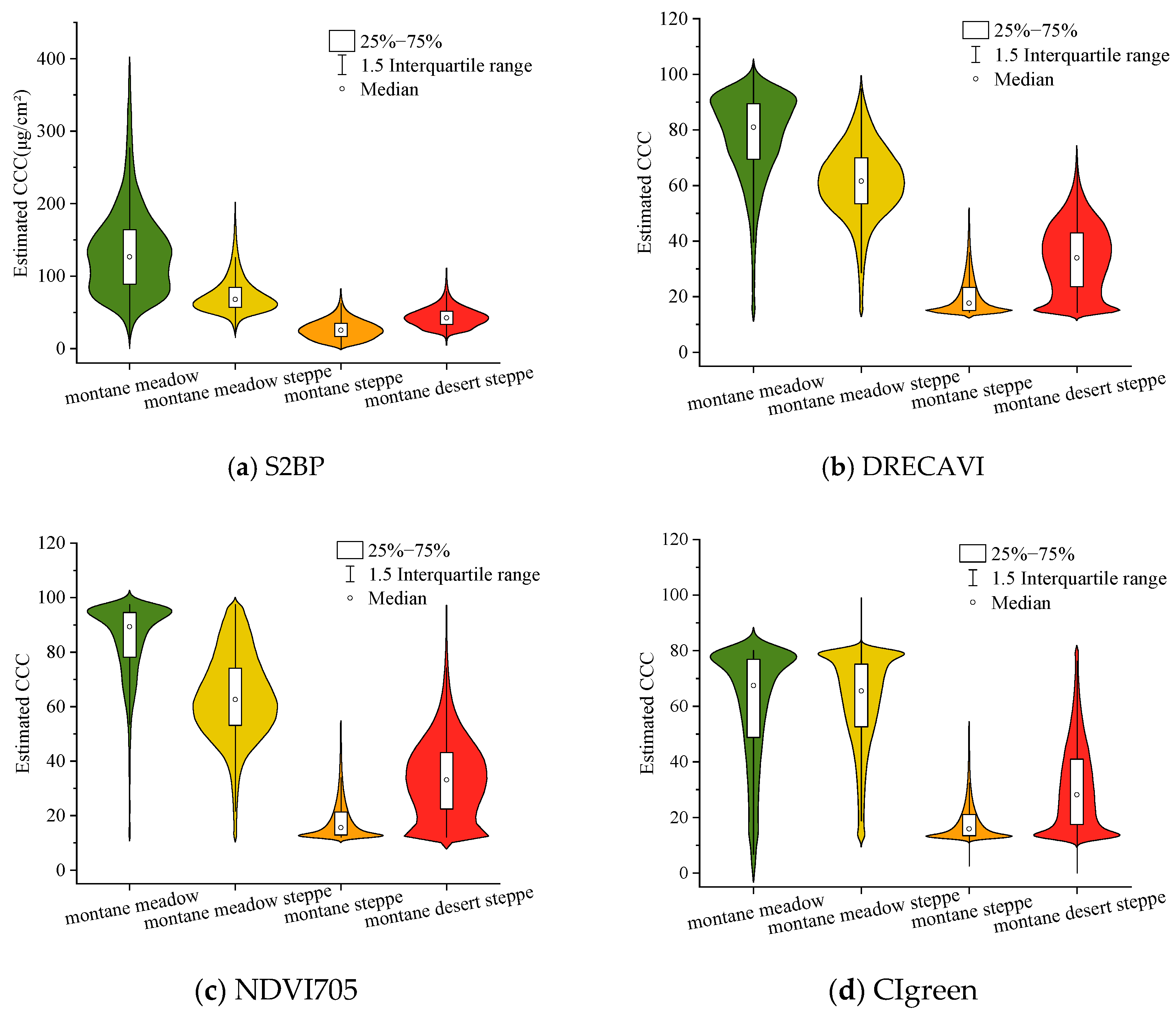
To validate the performance advantage of our newly developed DRECAVI in complex mountainous terrain, we compared its CCC estimation capability with the hybrid model (S2BP), and two high-precision, commonly used VIs (NDVI705 and CIgreen). Figure 8 illustrates the distribution characteristics of CCC inversion results for four types of grasslands, derived from different methods (S2BP, DRECAVI, NDVI705, CIgreen). The central box represents the interquartile range, and the white dot signifies the median. The breadth of the graph signifies the concentration of the data points across various values, with broader sections representing greater densities.

Figure 8.
Comparison of the distribution characteristics of the CCC inversion results for four types of grasslands: (a) The violin plot of the S2BP based on the SNAP; (b) the violin plot of DRECAVI; (c) the violin plot of NDVI705; (d) the violin plot of GIgreen. The violin plot shows the median, upper and lower quartiles, and upper and lower extreme values, and the breadth of the graph signifies the concentration of data points across various values.
Comparing the hybrid method (Figure 8a) and the empirical method (Figure 8b–d), it was evident that both methods yielded similar results, indicating that the CCC was related to different grassland types, roughly in the order of montane steppe < montane desert steppe < montane meadow steppe < montane meadow. Vegetation in montane meadows, marked by dense growth and a higher LAI, exhibits the highest median CCC. By contrast, the montane steppe exhibited a lower median CCC than the montane desert steppe, marking it as the lowest among the compared vegetation types. The reason may be attributed to the species composition of these two grassland types. The montane steppe is predominantly composed of xerophytic grasses, such as drunken horse grass (Achnatherum inebrians (Hance) Keng) and needlegrass (Stipa capillata L.), which generally have low leaf chlorophyll content. In contrast, the montane desert steppe’s vegetation is primarily composed of xerophilous semi-shrubs that typically exhibit a higher LCC.
The S2BP inversion results demonstrated that the CCC estimates for each grassland type were generally clustered around the median values, with a notable bimodal distribution for the montane meadow estimates near the median (Figure 8a). While DRECAVI also identified a weak bimodal pattern in montane meadow, the two conventional VIs (NDVI705 and CIgreen) failed to capture this phenomenon. Figure 8b,c demonstrated that DRECAVI and NDVI705 yielded similar CCC estimates for three types of grasslands: montane meadow steppe, montane steppe, and montane desert steppe. However, in the high-productivity montane meadow, DRECAVI mitigated the saturation phenomenon to some extent, while NDVI705 exhibited saturation, thereby affecting the estimation accuracy. This finding aligns with some existing research results. Gao et al. [55,82] demonstrated that some classical VIs (e.g., NDVI and DVI) exhibit reduced sensitivity to chlorophyll and rapid saturation after critical thresholds of leaf coverage or chlorophyll content are reached. Furthermore, the inversion results of CIgreen contained a higher number of outliers, which significantly compromised its accuracy. DRECAVI demonstrated significantly superior performance in both chlorophyll content estimation distribution and outlier suppression compared to other benchmark VIs.
4. Discussion
Green plants exhibit distinct spectral reflectance characteristics, such as the strong absorption of chlorophyll in the blue-light and red-light bands, and reflectance peaks in the green and NIR bands [83]. These biophysical signatures form the foundation for non-destructive chlorophyll content quantification through spectral measurements. Empirical regression models leveraging VIs have been widely adopted in homogeneous ecosystems (e.g., croplands, monoculture forests) due to their operational simplicity and broad applicability in linking spectral data to chlorophyll dynamics [30,55]. However, in topographically complex regions (e.g., mountainous areas), terrain effects and complex canopy structures can easily lead to systematic biases in VI estimations [84], thereby substantially increasing uncertainties in remote sensing retrievals. Currently, widely adopted VIs (e.g., NDVI, EVI) are predominantly derived from broadband multispectral data (e.g., Landsat, MODIS). Their limited spectral resolution fails to resolve the subtle variations in chlorophyll-sensitive spectral features, thereby constraining their performance in vegetation parameter inversion for heterogeneous mountainous vegetation.
This study developed a new dual-interference-resistant VI (DRECAVI) by integrating ground-measured hyperspectral data with Sentinel-2 satellite imagery. The methodology used the high spectral resolution of the measured hyperspectral data to accurately characterize chlorophyll absorption features and took advantage of the extensive spatial coverage of satellite data to enhance spatial applicability. The index design of DRECAVI included two sub-modules with clear biophysical significance. The first sub-module was the red-edge anti-saturation module, represented by (B7 − B4)/(B7 + B4). It constructed a structure similar to the NDVI using the red-edge band B7 and the red-light band B4. By normalizing the difference between the red-edge tail region (783 nm) and the red-light band, it enhanced sensitivity to areas with high chlorophyll content and effectively mitigated the saturation phenomenon commonly observed in traditional red-NIR indices (such as NDVI) [79,85]. The second sub-module was the aerosol anti-interference module, represented by (B8 − B1)/(B8 + B1). It coupled the NIR band B8 with the coastal aerosol band B1 to construct an atmospheric-interference-resistant unit. The combination of these two bands suppressed the interference caused by complex terrain [77] and enhanced the signal-to-noise ratio of vegetation signals. Research shows that the application of band reflectance ratio methods (such as simple band ratio or normalized difference ratio) can significantly reduce the radiation distortion caused by terrain [52,86] and mitigate the interference of non-vegetation elements [87]. Based on these findings, this study designed a normalized ratio combination framework. The final DRECAVI was constructed by linearly superimposing the two normalized difference ratio modules described earlier. Through this design, the contributions of different spectral features from different bands were balanced, thereby enhancing the generalization ability and robustness of the model in complex environments. Experimental results showed that in the chlorophyll content inversion in the Tianshan Mountains, the DRECAVI provided the highest estimation accuracy and offered more accurate vegetation information. This finding corroborates the conclusion that the combination of red-edge and NIR bands can effectively enhance the accuracy of chlorophyll inversion [88,89].
It is widely believed that the Sentinel-2 band B5 (705 nm) has the optimal capability for chlorophyll content inversion in the red-edge region [90]. For instance, Kganyago argued that among the three Sentinel-2 MSI red-edge bands, B5 shows higher robustness in estimating biophysical parameters [91]. Delloye et al. further confirmed that differences in chlorophyll content cause significant changes in canopy reflectance in the visible domain [92], with the most dramatic changes occurring in the red-edge region below 730 nm [91]. However, this study demonstrates that the DRECAVI (using band B7) achieves higher estimation accuracy compared to other red-edge indices (e.g., NDVI705, CIred-edge, and NDRE). Compared to these indices, DRECAVI increased R2 values by 2.78–37.04%, decreased RMSE by 3.23–24.60%, and reduced MAE by 6.58–20.13%. This phenomenon may be closely related to the red-edge shift effect. An increase in chlorophyll content leads to a shift in the red-edge reflectance slope toward longer wavelengths [27]. The B7 band, located at the tail of the red-edge region, is particularly suitable for capturing the cumulative effect of canopy chlorophyll content. Similar conclusions were corroborated by Clevers et al. [45] whose study demonstrated that the VI incorporating band B7 of Sentinel-2 exhibited significant advantages in crop chlorophyll content retrieval.
Blending physical models with empirical methods, hybrid approaches are regarded as the most advanced techniques in their field [93]. The S2BP tool, employing the ANN method, utilizes Sentinel-2 data to generate S2BP products, including CCC and other biophysical variables. The S2BP enables the generation of vegetation biophysical variables, characterized by a 10 m spatial resolution and a 5-day temporal resolution. These S2BP products are accompanied by quality indicators [60], ensuring the reliability of the data. Moreover, it has a universal processor and does not require input from a specific land cover type, enhancing its adaptability for retrieving vegetation’s biophysical variables [42,94]. Through our research, the simulated values of CCC correspond closely to the ground measurements, without saturation problems. These characteristics indicate that S2BP products hold significant potential for grassland monitoring, although they are slightly less accurate than the VI method. The disadvantage is that the S2BP algorithm, which relies on PROSAIL simulations for training neural networks (NNs), requires a relatively long training time [95]. In addition, because it belongs to a black box model, parameter adjustment is very complicated, which also affects its universality [93]. Improving the S2BP estimation algorithm is essential [42].
5. Conclusions
This study focused on the mountainous heterogeneous grasslands in the middle section of the Tianshan Mountains. Based on the spectral–spatial complementarity theory, we proposed an efficient method for inverting CCC in mountainous vegetation through the synergistic integration of multi-source remote sensing data. This approach eliminated the need for complex topographic corrections and relied solely on vegetation’s spectral characteristics and remote sensing imagery.
Our analysis of ground hyperspectral data reveals that the chlorophyll-sensitive spectral zones in typical grassland vegetation are predominantly located in the blue-light (407–446 nm) and red-light (612–684 nm) regions. The blue band exhibits a significant response to atmospheric scattering, while the red band effectively captures chlorophyll absorption features. Based on these chlorophyll-sensitive spectral bands, we developed a new index, DRECAVI, using Sentinel-2’s B1 (blue), B4 (red), B7 (red-edge), and B8 (NIR) bands. The blue (B1) and NIR (B8) bands were selected to mitigate topographic and atmospheric effects in mountainous regions, whereas the red (B4) and red-edge (B7) bands collectively reduced saturation in high-biomass areas. Compared to commonly used VIs and the hybrid method, the accuracy of the DRECAVI model was slightly higher than that of the hybrid model and the NDVI705 index model. DRECAVI demonstrated superior performance in estimating CCC in mountainous regions. It optimized the combination of biochemical and physical characteristics, and provided more accurate vegetation information. Moreover, this study confirms the application potential of the synergistic mechanism between band B1 and band B7 of the Sentinel-2 satellite, which may have been overlooked in previous research.
Overall, this study demonstrates that the integration of multi-source data can significantly enhance the capability of vegetation parameter inversion in heterogeneous environments. However, challenges persist due to mountainous terrain complexity and limited ground sampling, potentially affecting model generalizability. Future efforts should focus on expanding sample collection across different altitudinal gradients and grassland types, and combining radiative transfer models with data-driven algorithms to improve the universality of the model. Additionally, the Sentinel-2 satellite data from the ESA exhibited exceptional performance for CCC retrieval in heterogeneous grasslands, indicating its significant potential for biological monitoring in areas with complex vegetation structures.
Author Contributions
Conceptualization, Y.Z. and A.M.; Methodology, A.M. and Y.Z.; Software, Y.Z. and Y.L. (Yang Li); Validation, Y.Z., Y.W. and A.M.; Formal analysis, Y.L. (Yang Li) and T.A.; Investigation, Y.Z., Y.W. and Y.L. (Yan Liu); Data curation, Y.Z., Y.W., T.A. and Y.L. (Yang Li); Supervision, A.M. and T.A.; Writing—original draft, Y.Z.; Writing—review and editing, Y.Z., A.M., T.A., Y.W. and Y.L. (Yan Liu). All authors have read and agreed to the published version of the manuscript.
Funding
This research was funded by the Natural Science Foundation of Xinjiang Uygur Autonomous Region (2022D01A370), the Basic Scientific Research Fund of Central Public Welfare Research Institutes (IDM2021004), and the Shanghai Cooperation Organization (SCO) Science and Technology Partnership Program and International Science and Technology Cooperation Program (2023E01006).
Data Availability Statement
No new data were created or analyzed in this study. Data sharing does not apply to this article.
Acknowledgments
The authors gratefully acknowledge ESA for providing the Sentinel-2 data. We thank our colleagues who participated in the field surveys and data collection.
Conflicts of Interest
The authors declare no conflicts of interest.
References
- Latham, J.; Cumani, R.; Rosati, I.; Bloise, M. Global Land Cover Share (GLC-SHARE) Database Beta—Release Version 1.0—2014; FAO: Rome, Italy, 2014; pp. 15–23. [Google Scholar]
- Dougherty, C.T. Grasslands: Developments, Opportunities, Perspectives. Crop Sci. 2006, 46, 2304. [Google Scholar] [CrossRef]
- Sala, O.E.; Chapin, F.S.; Armesto, J.J.; Berlow, E.; Bloomfield, J.; Dirzo, R.; Huber-Sanwald, E.; Huenneke, L.F.; Jackson, R.B.; Kinzig, A.; et al. Global Biodiversity Scenarios for the Year 2100. Science 2000, 287, 1770–1774. [Google Scholar] [CrossRef]
- Stanimirova, R.; Arévalo, P.; Kaufmann, R.K.; Maus, V.; Lesiv, M.; Havlík, P.; Friedl, M.A. Sensitivity of Global Pasturelands to Climate Variation. Earth’s Future 2019, 7, 1353–1366. [Google Scholar] [CrossRef]
- Gang, C.; Zhou, W.; Chen, Y.; Wang, Z.; Sun, Z.; Li, J.; Qi, J.; Odeh, I. Quantitative Assessment of the Contributions of Climate Change and Human Activities on Global Grassland Degradation. Environ. Earth Sci. 2014, 72, 4273–4282. [Google Scholar] [CrossRef]
- Smith, W.K.; Dannenberg, M.P.; Yan, D.; Herrmann, S.; Barnes, M.L.; Barron-Gafford, G.A.; Biederman, J.A.; Ferrenberg, S.; Fox, A.M.; Hudson, A.; et al. Remote Sensing of Dryland Ecosystem Structure and Function: Progress, Challenges, and Opportunities. Remote Sens. Environ. 2019, 233, 111401. [Google Scholar] [CrossRef]
- Zheng, F.; Xu, B.; Xiao, P.; Zhang, X.; Manlike, A.; Jin, Y.; Li, C.; Feng, X.; An, S. Estimation of Chlorophyll Content in Mountain Steppe Using in Situ Hyperspectral Measurements. Spectrosc. Lett. 2021, 54, 495–506. [Google Scholar] [CrossRef]
- Viña, A.; Gitelson, A.A. New Developments in the Remote Estimation of the Fraction of Absorbed Photosynthetically Active Radiation in Crops. Geophys. Res. Lett. 2005, 32, 1–4. [Google Scholar] [CrossRef]
- Li, W.; Pacheco-Labrador, J.; Migliavacca, M.; Miralles, D.; van Dijke, A.H.; Reichstein, M.; Forkel, M.; Zhang, W.; Frankenberg, C.; Panwar, A.; et al. Widespread and Complex Drought Effects on Vegetation Physiology Inferred from Space. Nat. Commun. 2023, 14, 4640. [Google Scholar] [CrossRef]
- Cornelissen, J.H.C.; Lavorel, S.; Garnier, E.; Díaz, S.; Buchmann, N.; Gurvich, D.E.; Reich, P.B.; ter Steege, H.; Morgan, H.D.; van der Heijden, M.G.A.; et al. A Handbook of Protocols for Standardised and Easy Measurement of Plant Functional Traits Worldwide. Aust. J. Bot. 2003, 51, 335–380. [Google Scholar] [CrossRef]
- Croft, H.; Chen, J.; Wang, R.; Mo, G.; Luo, S.; Luo, X.; He, L.; Gonsamo, A.; Arabian, J.; Zhang, Y.; et al. The Global Distribution of Leaf Chlorophyll Content. Remote Sens. Environ. 2020, 236, 111479. [Google Scholar] [CrossRef]
- Peng, Y.; Gitelson, A.A.; Keydan, G.; Rundquist, D.C.; Moses, W. Remote Estimation of Gross Primary Production in Maize and Support for a New Paradigm based on Total Crop Chlorophyll Content. Remote Sens. Environ. 2011, 115, 978–989. [Google Scholar] [CrossRef]
- Porcar-Castell, A.; Tyystjärvi, E.; Atherton, J.; Van der Tol, C.; Flexas, J.; Pfündel, E.E.; Moreno, J.; Frankenberg, C.; Berry, J.A. Linking Chlorophyll a Fluorescence to Photosynthesis for Remote Sensing Applications: Mechanisms and Challenges. J. Exp. Bot. 2014, 65, 4065–4095. [Google Scholar] [CrossRef]
- Sims, D.A.; Gamon, J.A. Relationships Between Leaf Pigment Content and Spectral Reflectance across a Wide Range of Species, Leaf Structures and Developmental Stages. Remote Sens. Environ. 2002, 81, 337–354. [Google Scholar] [CrossRef]
- Lawlor, D.W.; Tezara, W. Causes of Decreased Photosynthetic Rate and Metabolic Capacity in Water-deficient Leaf Cells: A Critical Evaluation of Mechanisms and Integration of Processes. Ann. Bot. 2009, 103, 561–579. [Google Scholar] [CrossRef]
- Clevers, J.G.P.W.; Kooistra, L. Using Hyperspectral Remote Sensing Data for Retrieving Total Canopy Chlorophyll and Nitrogen Content. IEEE J. Sel. Top. Appl. Earth Obs. Remote Sens. 2012, 5, 574–583. [Google Scholar] [CrossRef]
- Tsele, P.; Ramoelo, A.; Qabaqaba, M.; Mafanya, M.; Chirima, G. Validation of LAI, Chlorophyll and FVC Biophysical Estimates from Sentinel-2 Level 2 Prototype Processor over a Heterogeneous Savanna and Grassland Environment in South Africa. Geocarto Int. 2022, 37, 14355–14378. [Google Scholar] [CrossRef]
- Zhang, Y.; Li, Y.; Wang, R.; Xu, L.; Li, M.; Liu, Z.; Wu, Z.; Zhang, J.; Yu, G.; He, N. Spatial Variation of Leaf Chlorophyll in Northern Hemisphere Grasslands. Front. Plant Sci. 2020, 11, 1244. [Google Scholar] [CrossRef]
- Ali, A.M.; Darvishzadeh, R.; Skidmore, A.; Gara, T.W.; O’Connor, B.; Roeoesli, C.; Heurich, M.; Paganini, M. Comparing Methods for Mapping Canopy Chlorophyll Content in a Mixed Mountain Forest Using Sentinel-2 Data. Int. J. Appl. Earth Obs. Geoinf. 2020, 87, 102037. [Google Scholar] [CrossRef]
- Imran, H.A.; Gianelle, D.; Rocchini, D.; Dalponte, M.; Martín, M.P.; Sakowska, K.; Wohlfahrt, G.; Vescovo, L. VIS-NIR, Red-Edge and NIR-Shoulder Based Normalized Vegetation Indices Response to Co-Varying Leaf and Canopy Structural Traits in Heterogeneous Grasslands. Remote Sens. 2020, 12, 2254. [Google Scholar] [CrossRef]
- Bayat, B.; van der Tol, C.; Verhoef, W. Integrating Satellite Optical and Thermal Infrared Observations for Improving Daily Ecosystem Functioning Estimations during a Drought Episode. Remote Sens. Environ. 2018, 209, 375–394. [Google Scholar] [CrossRef]
- Bayat, B.; Van der Tol, C.; Verhoef, W. Remote Sensing of Grass Response to Drought Stress Using Spectroscopic Techniques and Canopy Reflectance Model Inversion. Remote Sens. 2016, 8, 557. [Google Scholar] [CrossRef]
- Sonobe, R.; Yamashita, H.; Mihara, H.; Morita, A.; Ikka, T. Hyperspectral Reflectance Sensing for Quantifying Leaf Chlorophyll Content in Wasabi Leaves Using Spectral Pre-processing Techniques and Machine Learning Algorithms. Int. J. Remote Sens. 2021, 42, 1311–1329. [Google Scholar] [CrossRef]
- Tong, A.; He, Y. Estimating and Mapping Chlorophyll Content for a Heterogeneous Grassland: Comparing Prediction Power of a Suite of Vegetation Indices Across Scales between Years. ISPRS J. Photogramm. Remote Sens. 2017, 126, 146–167. [Google Scholar] [CrossRef]
- Sun, H.; Xu, Z.; Liu, H. An Evaluation of the Response of Vegetation Greenness, Moisture, Fluorescence, and Temperature-based Remote Sensing Indicators to Drought Stress. J. Hydrol. 2023, 625, 130125. [Google Scholar] [CrossRef]
- Wan, L.; Ryu, Y.; Dechant, B.; Lee, J.; Zhong, Z.; Feng, H. Improving Retrieval of Leaf Chlorophyll Content from Sentinel-2 and Landsat-7/8 Imagery by Correcting for Canopy Structural Effects. Remote Sens. Environ. 2024, 304, 114048. [Google Scholar] [CrossRef]
- Horler, D.N.H.; Dockray, M.; Barber, J. The red edge of plant leaf reflectance. Int. J. Remote Sens. 1983, 4, 273–288. [Google Scholar] [CrossRef]
- Gitelson, A.A.; Merzlyak, M.N.; Lichtenthaler, H.K. Detection of Red Edge Position and Chlorophyll Content by Reflectance Measurements Near 700 nm. J. Plant Physiol. 1996, 148, 501–508. [Google Scholar] [CrossRef]
- Gitelson, A.A.; Kaufman, Y.J.; Merzlyak, M.N. Use of a Green Channel in Remote Sensing of Global Vegetation from EOS–MODIS. Remote Sens. Environ. 1996, 58, 289–298. [Google Scholar] [CrossRef]
- Frampton, W.J.; Dash, J.; Watmough, G.; Milton, E.J. Evaluating the Capabilities of Sentinel-2 for Quantitative Estimation of Biophysical Variables in Vegetation. ISPRS J. Photogramm. Remote Sens. 2013, 82, 83–92. [Google Scholar] [CrossRef]
- Peng, Y.; Nguy-Robertson, A.; Arkebauer, T.; Gitelson, A.A. Assessment of Canopy Chlorophyll Content Retrieval in Maize and Soybean: Implications of Hysteresis on the Development of Generic Algorithms. Remote Sens. 2017, 9, 226. [Google Scholar] [CrossRef]
- Sehgal, V.K.; Chakraborty, D.; Sahoo, R.N. Inversion of Radiative Transfer Model for Retrieval of Wheat Biophysical Parameters from Broadband Reflectance Measurements. Inf. Process. Agric. 2016, 3, 107–118. [Google Scholar] [CrossRef]
- Jacquemoud, S.; Verhoef, W.; Baret, F.; Bacour, C.; Zarco-Tejada, P.J.; Asner, G.P.; François, C.; Ustin, S.L. PROSPECT+SAIL models: A Review of Use for Vegetation Characterization. Remote Sens. Environ. 2009, 113, S56–S66. [Google Scholar] [CrossRef]
- Atzberger, C.; Richter, K.; Vuolo, F.; Darvishzadeh, R.; Schlerf, M. Why Confining to Vegetation Indices? Exploiting the Potential of Improved Spectral Observations Using Radiative Transfer Models. In Remote Sensing for Agriculture, Ecosystems, and Hydrology XIII; SPIE: Czechia, Prague, 2011. [Google Scholar] [CrossRef]
- Lu, B.; Proctor, C.; He, Y. Investigating Different Versions of PROSPECT and PROSAIL for Estimating Spectral and Biophysical Properties of Photosynthetic and Non-photosynthetic Vegetation in Mixed Grasslands. GIScience Remote Sens. 2021, 58, 354–371. [Google Scholar] [CrossRef]
- Pacheco-Labrador, J.; El-Madany, T.S.; van der Tol, C.; Martin, M.P.; Gonzalez-Cascon, R.; Perez-Priego, O.; Guan, J.; Moreno, G.; Carrara, A.; Reichstein, M.; et al. senSCOPE: Modeling Mixed Canopies Combining Green and Brown Senesced Leaves. Evaluation in a Mediterranean Grassland. Remote Sens. Environ. 2021, 257, 112352. [Google Scholar] [CrossRef]
- Jacquemoud, S.; Baret, F. PROSPECT: A Model of Leaf Optical Properties Spectra. Remote Sens. Environ. 1990, 34, 75–91. [Google Scholar] [CrossRef]
- Verhoef, W. Light Scattering by Leaf Layers with Application to Canopy Reflectance Modeling: The SAIL Model. Remote Sens. Environ. 1984, 16, 125–141. [Google Scholar] [CrossRef]
- Singh, P.; Srivastava, P.K.; Verrelst, J.; Mall, R.K.; Rivera, J.P.; Dugesar, V.; Prasad, R. High Resolution Retrieval of Leaf Chlorophyll Content over Himalayan Pine Forest Using Visible/IR Sensors Mounted on UAV and Radiative Transfer Model. Ecol. Inform. 2023, 75, 102099. [Google Scholar] [CrossRef]
- Xu, L.; Shi, S.; Gong, W.; Chen, B.; Sun, J.; Xu, Q.; Bi, S. Maping 3D Plant Chlorophyll Distribution from Hyperspectral LiDAR by a Leaf-canopyradiative Transfer Model. Int. J. Appl. Earth Obs. Geoinf. 2024, 127, 103649. [Google Scholar] [CrossRef]
- Atzberger, C. Object-based Retrieval of Biophysical Canopy Variables Using Artificial Neural Nets and Radiative Transfer Models. Remote Sens. Environ. 2004, 93, 53–67. [Google Scholar] [CrossRef]
- Hassanpour, R.; Majnooni-Heris, A.; Fakheri Fard, A.; Verrelst, J. Monitoring Biophysical Variables (FVC, LAI, LCab, and CWC) and Cropland Dynamics at Field Scale Using Sentinel-2 Time Series. Remote Sens. 2024, 16, 2284. [Google Scholar] [CrossRef]
- Verrelst, J.; Camps-Valls, G.; Muñoz-Marí, J.; Rivera, J.P.; Veroustraete, F.; Clevers, J.G.P.W.; Moreno, J. Optical Remote Sensing and the Retrieval of Terrestrial Vegetation Bio-geophysical Properties—A review. ISPRS J. Photogramm. Remote Sens. 2015, 108, 273–290. [Google Scholar] [CrossRef]
- Zhao, Y.; Hou, P.; Jiang, J.; Jiang, Y.; Zhang, B.; Bai, J.; Xu, H. Progress in Quantitative Inversion of Vegetation Ecological Remote Sensing Parameters. Natl. Remote Sens. Bull. 2021, 25, 2173–2197. [Google Scholar] [CrossRef]
- Clevers, J.G.P.W.; Kooistra, L.; Van den Brande, M.M.M. Using Sentinel-2 Data for Retrieving LAI and Leaf and Canopy Chlorophyll Content of a Potato Crop. Remote Sens. 2017, 9, 405. [Google Scholar] [CrossRef]
- Tomíček, J.; Mišurec, J.; Lukeš, P. Prototyping a Generic Algorithm for Crop Parameter Retrieval across the Season Using Radiative Transfer Model Inversion and Sentinel-2 Satellite Observations. Remote Sens. 2021, 13, 3659. [Google Scholar] [CrossRef]
- Yu, H.; Yin, G.; Liu, G.; Ye, Y.; Qu, Y.; Xu, B.; Verger, A. Validation of Sentinel-2, MODIS, CGLS, SAF, GLASS and C3S Leaf Area Index Products in Maize Crops. Remote Sens. 2021, 13, 4529. [Google Scholar] [CrossRef]
- Zhen, J.; Jiang, X.; Xu, Y.; Miao, J.; Zhao, D.; Wang, J.; Wang, J.; Wu, G. Mapping Leaf Chlorophyll Content of Mangrove Forests with Sentinel-2 Images of Four Periods. Int. J. Appl. Earth Obs. Geoinf. 2021, 102, 102387. [Google Scholar] [CrossRef]
- Sakowska, K.; Juszczak, R.; Gianelle, D. Remote Sensing of Grassland Biophysical Parameters in the Context of the Sentinel-2 Satellite Mission. J. Sens. 2016, 2016, 4612809. [Google Scholar] [CrossRef]
- Tsele, P.; Ramoelo, A.; Qabaqaba, M. Development of the Grass LAI and CCC Remote Sensing-based Models and Their Transferability Using Sentinel-2 Data in Heterogeneous Grasslands. Int. J. Remote Sens. 2023, 44, 2643–2667. [Google Scholar] [CrossRef]
- Schwieder, M.; Buddeberg, M.; Kowalski, K.; Pfoch, K.; Bartsch, J.; Bach, H.; Pickert, J.; Hostert, P. Estimating Grassland Parameters from Sentinel-2: A Model Comparison Study. PFG-J. Photogramm. Remote Sens. Geoinf. Sci. 2020, 88, 379–390. [Google Scholar] [CrossRef]
- Jiang, H.; He, G.; Huang, H.; Cao, X.; Wang, X.; Zhang, Z. Construction and Validation of Combination Model of Topography-adjusted Vegetation Index Based on Band-ratio Model. Trans. Chin. Soc. Agric. Eng. 2017, 33, 156–161. [Google Scholar] [CrossRef]
- Wu, Z.; Xu, H. A New Index for Vegetation Enhancements of Mountainous Regions Based on Satellite Image Data. J. Geo-Inf. Sci. 2011, 13, 656–664. [Google Scholar] [CrossRef]
- Zarco-Tejada, P.J.; Hornero, A.; Beck, P.S.A.; Kattenborn, T.; Kempeneers, P.; Hernández-Clemente, R. Chlorophyll Content Estimation in an Open-canopy Conifer Forest with Sentinel-2A and Hyperspectral Imagery in the Context of Forest Decline. Remote Sens. Environ. 2019, 223, 320–335. [Google Scholar] [CrossRef]
- Gao, S.; Yan, K.; Liu, J.; Pu, J.; Zou, D.; Qi, J.; Mu, X.; Yan, G. Assessment of Remote-sensed Vegetation Indices for Estimating Forest Chlorophyll Concentration. Ecol. Indic. 2024, 162, 112001. [Google Scholar] [CrossRef]
- Zhang, Y.; Han, X.; Yang, J. Selection of Optimal Spectral Features for Leaf Chlorophyll Content Estimation. Sci. Rep. 2024, 14, 25598. [Google Scholar] [CrossRef]
- Li, Y.; Xu, X.; Wu, W.; Zhu, Y.; Gao, L.; Jiang, X.; Meng, Y.; Yang, G.; Xue, H. Hyperspectral estimation of chlorophyll content in grapevine based on feature selection and GA-BP. Sci. Rep. 2025, 15, 8029. [Google Scholar] [CrossRef]
- Zhang, Y.; Liu, L.; Liu, Y.; Zhang, M.; An, C. Response of Altitudinal Vegetation Belts of the Tianshan Mountains in Northwestern China to Climate Change During 1989–2015. Sci. Rep. 2021, 11, 4870. [Google Scholar] [CrossRef] [PubMed]
- Korban, A. Distribution of Grassland Types and Vegetation Dominant Species in Xinjiang. Prataculture Anim. Husb. 2014, 4, 15–17. [Google Scholar]
- Weiss, M.; Baret, F.; Jay, S. S2ToolBox Level 2 Products: LAI, FAPAR, FCOVER; Version 2.0; Institut National de la Recherche Agronomique (INRA), Avignon: Paris, France, 2020. [Google Scholar]
- Zhang, R.; Yang, P.; Liu, S.; Wang, C.; Liu, J. Evaluation of the Methods for Estimating Leaf Chlorophyll Content with SPAD Chlorophyll Meters. Remote Sens. 2022, 14, 5144. [Google Scholar] [CrossRef]
- Gholizadeh, A.; Saberioon, M.; Borůvka, L.; Wayayok, A.; Soom, M.A.M. Leaf Chlorophyll and Nitrogen Dynamics and Their Relationship to Lowland Rice Yield for Site-specific Paddy Management. Inf. Process. Agric. 2017, 4, 259–268. [Google Scholar] [CrossRef]
- Wei, L.; Lu, L.; Shang, Y.; Ran, X.; Liu, Y.; Fang, Y. Can SPAD Values and CIE L*a*b* Scales Predict Chlorophyll and Carotenoid Concentrations in Leaves and Diagnose the Growth Potential of Trees? An Empirical Study of Four Tree Species. Horticulturae 2024, 10, 548. [Google Scholar] [CrossRef]
- Gitelson, A.A.; Viña, A.; Ciganda, V.; Rundquist, D.C.; Arkebauer, T.J. Remote Estimation of Canopy Chlorophyll Content in Crops. Geophys. Res. Lett. 2005, 32, L08403. [Google Scholar] [CrossRef]
- Wang, Z.; Li, F. Methods and Results of Developing Canopy Chlorophyll Data Set of Winter Wheat in Yucheng, Shandong Province by Integrating Sentinel-2 Satellite and Ground Verification Site Data. J. Glob. Change Data Discov. 2021, 5, 111–119. [Google Scholar] [CrossRef]
- Chen, J.; Jönsson, P.; Tamura, M.; Gu, Z.; Matsushita, B.; Eklundh, L. A Simple Method for Reconstructing a High-quality NDVI Time-series Data Set Based on the Savitzky-Golay Filter. Remote Sens. Environ. 2004, 91, 332–344. [Google Scholar] [CrossRef]
- Drusch, M.; Bello, U.D.; Carlier, S.; Colin, O.; Fernandez, V.; Gascon, F.; Hoersch, B.; Isola, C.; Laberinti, P.; Martimort, P.; et al. Sentinel-2: ESA’s Optical High-Resolution Mission for GMES Operational Services. Remote Sens. Environ. 2012, 120, 25–36. [Google Scholar] [CrossRef]
- Liu, K.; Zhou, Q.; Wu, W.; Chen, Z.; Tang, H. Comparison between Multispectral and Hyperspectral Remote Sensing for LAI Estimation. Trans. Chin. Soc. Agric. Eng. 2016, 32, 155–162. [Google Scholar] [CrossRef]
- Rouse, J.W.; Hass, R.H.; Schell, J.A.; Deering, D.W. Monitoring Vegetation Systems in the Great Plains with ERTS. In Proceedings of the Third Earth Resources Technology Satellite-1 Symposium, Washington, DC, USA, 10–14 December 1973. [Google Scholar]
- Evangelides, C.; Nobajas, A. Red-Edge Normalised Difference Vegetation Index (NDVI705) from Sentinel-2 Imagery to Assess Post-fire Regeneration. Remote Sens. Appl. Soc. Environ. 2020, 17, 100283. [Google Scholar] [CrossRef]
- Lin, S.; Li, J.; Liu, Q.; Li, L.; Zhao, J.; Yu, W. Evaluating the Effectiveness of Using Vegetation Indices Based on Red-Edge Reflectance from Sentinel-2 to Estimate Gross Primary Productivity. Remote Sens. 2019, 11, 1303. [Google Scholar] [CrossRef]
- Thompson, C.N.; Guo, W.; Sharma, B.; Ritchie, G.L. Using Normalized Difference Red-edge Index to Assess Maturity in Cotton. Crop Sci. 2019, 59, 2167–2177. [Google Scholar] [CrossRef]
- Daughtry, C.S.T.; Walthall, C.L.; Kim, M.S.; de Colstoun, E.B.; McMurtrey, J.E. Estimating Corn Leaf Chlorophyll Concentration from Leaf and Canopy Reflectance. Remote Sens. Environ. 2000, 74, 229–239. [Google Scholar] [CrossRef]
- Qi, J.; Chehbouni, A.; Huete, A.R.; Kerr, Y.H.; Sorooshian, S. A Modified Soil Adjusted Vegetation Index. Remote Sens. Environ. 1994, 48, 119–126. [Google Scholar] [CrossRef]
- Willmott, C.J.; Ackleson, S.G.; Davis, R.E.; Feddema, J.J.; Klink, K.M.; Legates, D.R.; O’Donnell, J.; Rowe, C.M. Statistics for the Evaluation and Comparison of Models. J. Geophys. Res. Ocean 1985, 90, 8995–9005. [Google Scholar] [CrossRef]
- Jiang, X.; Zhen, J.; Miao, J.; Zhao, D.; Shen, Z.; Jiang, J.; Gao, C.; Wu, G.; Wang, J. Newly-developed Three-band Hyperspectral Vegetation Index for Estimating Leaf Relative Chlorophyll Content of Mangrove Under Different Severities of Pest and Disease. Ecol. Indic. 2022, 140, 108978. [Google Scholar] [CrossRef]
- Liu, H.; Huete, A. A Feedback Based Modification of the NDVI to Minimize Canopy Background and Atmospheric Noise. IEEE Trans. Geosci. Remote Sens. 1995, 33, 457–465. [Google Scholar] [CrossRef]
- Zhang, X.; Sun, H.; Qiao, X.; Yan, X.; Feng, M.; Xiao, L.; Song, X.; Zhang, M.; Shafiq, F.; Yang, W.; et al. Hyperspectral Estimation of Canopy Chlorophyll of Winter Wheat by Using the Optimized Vegetation Indices. Comput. Electron. Agric. 2022, 193, 106654. [Google Scholar] [CrossRef]
- Qiao, K.; Zhu, W.; Xie, Z. Application Conditions and Impact Factors for Various Vegetation Indices in Constructing the LAI Seasonal Trajectory Over Different Vegetation Types. Ecol. Indic. 2020, 112, 106153. [Google Scholar] [CrossRef]
- Nagler, P.L.; Daughtry, C.S.T.; Goward, S.N. Plant Litter and Soil Reflectance. Remote Sens. Environ. 2000, 71, 207–215. [Google Scholar] [CrossRef]
- Voitik, A.; Kravchenko, V.; Pushka, O.; Kutkovetska, T.; Shchur, T.; Kocira, S. Comparison of NDVI, NDRE, MSAVI and NDSI Indices for Early Diagnosis of Crop Problems. Agric. Eng. 2023, 27, 47–57. [Google Scholar] [CrossRef]
- Huang, S.; Tang, L.; Hupy, J.; Wang, Y.; Shao, G. Correction to: Commentary Review on the Use of Normalized Difference Vegetation Index (NDVI) in the Era of Popular Remote Sensing. J. For. Res. 2021, 32, 2719. [Google Scholar] [CrossRef]
- Gitelson, A.A.; Gritz, Y.; Merzlyak, M.N. Relationships between Leaf Chlorophyll Content and Spectral Reflectance and Algorithms for Non-destructive Chlorophyll Assessment in Higher Plant Leaves. J. Plant Physiol. 2003, 160, 271–282. [Google Scholar] [CrossRef]
- Zhang, H.; Li, P.; Zhou, G.; Zhou, Y. Advances in the Studies on Topographic Effects of Vegetation Indices. Chin. J. Appl. Ecol. 2018, 29, 669–677. [Google Scholar] [CrossRef]
- Qiao, K.; Zhu, W.; Xie, Z.; Wu, S.; Li, S. New Three Red-edge Vegetation Index (VI3RE) for Crop Seasonal LAI Prediction Using Sentinel-2 Data. Int. J. Appl. Earth Obs. Geoinf. 2024, 130, 103894. [Google Scholar] [CrossRef]
- Chen, R.; Yin, G.; Liu, G.; Li, J.; Verger, A. Evaluation and Normalization of Topographic Effects on Vegetation Indices. Remote Sens. 2020, 12, 2290. [Google Scholar] [CrossRef]
- Camps-Valls, G.; Campos-Taberner, M.; Moreno-Martínez, Á.; Walther, S.; Duveiller, G.; Cescatti, A.; Mahecha, M.D.; Muñoz-Marí, J.; García-Haro, F.J.; Guanter, L.; et al. A Unified Vegetation Index for Quantifying the Terrestrial Biosphere. Sci. Adv. 2021, 7, eabc7447. [Google Scholar] [CrossRef]
- Padalia, H.; Sinha, S.K.; Bhave, V.; Trivedi, N.K.; Kumar, A.S. Estimating Canopy LAI and Chlorophyll of Tropical Forest Plantation (North India) Using Sentinel-2 Data. Adv. Space Res. 2020, 65, 458–469. [Google Scholar] [CrossRef]
- Li, C.; Zhu, X.; Wei, Y.; Cao, S.; Guo, X.; Yu, X.; Chang, C. Estimating Apple Tree Canopy Chlorophyll Content based on Sentinel-2A Remote Sensing Imaging. Sci. Rep. 2018, 8, 3756. [Google Scholar] [CrossRef]
- Wu, C.; Niu, Z.; Tang, Q.; Huang, W. Estimating Chlorophyll Content from Hyperspectral Vegetation Indices: Modeling and Validation. Agric. For. Meteorol. 2008, 148, 1230–1241. [Google Scholar] [CrossRef]
- Kganyago, M.; Mhangara, P.; Adjorlolo, C. Estimating Crop Biophysical Parameters Using Machine Learning Algorithms and Sentinel-2 Imagery. Remote Sens. 2021, 13, 4314. [Google Scholar] [CrossRef]
- Delloye, C.; Weiss, M.; Defourny, P. Retrieval of the Canopy Chlorophyll Content from Sentinel-2 Spectral Bands to Estimate Nitrogen Uptake in Intensive Winter Wheat Cropping Systems. Remote Sens. Environ. 2018, 216, 245–261. [Google Scholar] [CrossRef]
- Upreti, D.; Huang, W.; Kong, W.; Pascucci, S.; Pignatti, S.; Zhou, X.; Ye, H.; Casa, R. A Comparison of Hybrid Machine Learning Algorithms for the Retrieval of Wheat Biophysical Variables from Sentinel-2. Remote Sens. 2019, 11, 481. [Google Scholar] [CrossRef]
- Hu, Q.; Yang, J.; Xu, B.; Huang, J.; Memon, M.S.; Yin, G.; Zeng, Y.; Zhao, J.; Liu, K. Evaluation of Global Decametric-Resolution LAI, FAPAR and FVC Estimates Derived from Sentinel-2 Imagery. Remote Sens. 2020, 12, 912. [Google Scholar] [CrossRef]
- Verrelst, J.; Rivera, J.P.; Veroustraete, F.; Muñoz-Marí, J.; Clevers, J.G.P.W.; Camps-Valls, G.; Moreno, J. Experimental Sentinel-2 LAI Estimation Using Parametric, Non-parametric and Physical Retrieval Methods—A comparison. ISPRS J. Photogramm. Remote Sens. 2015, 108, 260–272. [Google Scholar] [CrossRef]

Disclaimer/Publisher’s Note: The statements, opinions and data contained in all publications are solely those of the individual author(s) and contributor(s) and not of MDPI and/or the editor(s). MDPI and/or the editor(s) disclaim responsibility for any injury to people or property resulting from any ideas, methods, instructions or products referred to in the content. |
© 2025 by the authors. Licensee MDPI, Basel, Switzerland. This article is an open access article distributed under the terms and conditions of the Creative Commons Attribution (CC BY) license (https://creativecommons.org/licenses/by/4.0/).