Article

Exploring the Cooling Effects of Urban Wetlands in Colombo City, Sri Lanka

by
Darshana Athukorala
1,*,
Yuji Murayama
1,
N. S. K. Herath
2,
C. M. Madduma Bandara
3,
Rajeev Kumar Singh
4 and
S. L. J. Fernando
5
1
Institute of Life and Environmental Sciences, University of Tsukuba, 1-1-1 Tennodai, Tsukuba 305-8572, Japan
2
Department of Environmental Management, Rajarata University of Sri Lanka, Mihintale 50300, Sri Lanka
3
Department of Geography, University of Peradeniya, Peradeniya 20400, Sri Lanka
4
Department of International Relations, Kobe City University of Foreign Studies, 9 Chome-1, Gakuen Higashimachi, Nishi-ku, Kobe-shi, Hyogo-ken 651-2187, Japan
5
Department of Geography, Faculty of Humanities and Social Sciences, University of Ruhuna, Matara 81000, Sri Lanka
*
Author to whom correspondence should be addressed.
Remote Sens. 2025, 17(11), 1919; https://doi.org/10.3390/rs17111919 (registering DOI)
Submission received: 6 April 2025 / Revised: 17 May 2025 / Accepted: 29 May 2025 / Published: 31 May 2025
(This article belongs to the Special Issue Smart Monitoring of Urban Environment Using Remote Sensing)

Abstract

:
An urban heat island (UHI) refers to urban areas that experience higher temperatures due to heat absorption and retention by impervious surfaces compared to the surrounding rural areas. Urban wetlands are crucial in mitigating the UHI effect and improving climate resilience via their cooling effect. This study examines Colombo, Sri Lanka, the RAMSAR-accredited wetland city in South Asia, to assess the cooling effect of urban wetlands based on 2023 dry season data for effective sustainable management. We used Landsat 8 and 9 data to create Land Use/Cover (LUC), Land Surface Temperature (LST), and surface-reflectance-based maps using the Google Earth Engine (GEE). The Enhanced Vegetation Index (EVI), Modified Normalized Difference Water Index (mNDWI), topographic wetness, elevation, slope, and impervious surface percentage were identified as the influencing variables. The results show that urban wetlands in Colombo face tremendous pressure due to rapid urban expansion. The cooling intensity positively correlates with wetland size. The threshold value of efficiency (TVoE) of urban wetlands in Colombo was 1.42 ha. Larger and more connected wetlands showed higher cooling effects. Vegetation- and water-based wetlands play an important role in <10 km urban areas, while more complex shape configuration wetlands provide better cooling effects in urban and peri-urban areas due to edge effects. Urban planners should prioritize protecting wetland areas and ensuring hydrological connectivity and interconnected wetland clusters to maximize the cooling effect and sustain ecosystem services in rapidly urbanizing coastal cities.

1. Introduction

In recent decades, urban expansion has significantly changed landscape patterns [1,2,3,4,5], especially in developing countries [6,7,8,9]. More than 55% of the global population will live in urban areas [10,11], with projections revealing the urban expansion of 1.2 million km2 by 2030 [11]. Asia is expected to have nearly half of this growth, subsuming extensive natural landscapes into the urban environment [12,13,14]. Rapid urbanization has strengthened socio-economic development in urban areas, such as expanding urban infrastructure and transportation systems and improving healthcare services [2]. However, these advancements are often carried out in the face of various socio-ecological challenges, including widespread deforestation due to land conversion for urban use [15], excessive energy consumption by growing urban populations [16,17,18], severe environmental degradation from unplanned development [19], air pollution from industrial emissions and vehicular traffic [20], adverse health impacts [19,21,22], urban climate [23,24], water resources [25,26,27], and the intensification of the urban heat island (UHI) effect [28,29]. The UHI effect, a well-recognized climatic phenomenon caused by replacing natural landscapes with artificial surfaces [30,31,32,33], leads to increased heat storage during the daytime and slower heat diffusion at nighttime [34,35,36,37].
There are two distinct types of UHIs: atmospheric UHIs and surface UHIs [38]. Atmospheric UHIs estimate using two vertical layers—a canopy layer UHI (within the urban canopy) and a boundary layer UHI (above the canopy) [38]. In contrast, surface UHIs are evaluated using LST data derived from thermal infrared (TIR) remote sensing technology. Understanding the surface UHI effect is crucial because it shows how urban areas experience higher temperatures due to heat-absorbing surfaces, impacting urban climate resilience [38,39]. Therefore, our study focuses on surface UHIs to assess LST variations and identify effective strategies for urban cooling, especially in urban wetlands.
Urban wetlands have emerged as an effective strategy to mitigate the UHI effect [40,41,42,43]. Urban wetlands can remarkably regulate temperatures through evaporation and their high specific heat capacity [44,45], reducing ambient temperatures and enhancing urban sustainability and quality of life [46,47]. Many studies have shown the cooling ability of wetlands on climate conditions in various geographical regions [48,49,50,51]. Wetlands in urban and peri-urban areas within city boundaries are crucial for UHI mitigation [15,52,53]. Most research has concentrated on the cooling effects of blue-green infrastructure [54,55,56,57,58,59,60]. Wu et al., 2021 studied the cooling efficiency of urban wetlands in an inland megacity, Chengdu, Southwest China, and found that the cooling intensity increased with wetland size, while hydrological connectivity and high-intensity build-up areas significantly enhanced cooling efficiency [47]. Xue et al., 2019 studied the cooling effects of urban and peri-urban wetlands using remote sensing data in two inland cities in Northeast China [61]. They reported that the cooling capability of urban wetlands depends on the area, shape, and hydrological conditions. Therefore, there is still an urgent need to explore the specific characteristics of urban wetlands—such as size, shape, hydrological connectivity, spatial context (urban or peri-urban), and wetland type (vegetation- or water-based), as well as influencing factors such as the EVI, mNDWI, topographic wetness, elevation, slope, and impervious surface—to fully understand their cooling effect, especially in coastal cities.
For example, wetland size is a critical factor because larger wetlands have a greater capacity for evaporative cooling due to an increased surface area [15,51]. The shape is also important—complex or fragmented shapes may have higher edge effects, which can enhance or reduce the cooling efficiency of urban wetlands [47,62]. Hydrological connectivity is essential because hydrologically connected wetlands sustain a stable water supply, which is crucial for sustaining wetland vegetation and increasing the cooling capacity of urban wetlands [61]. The spatial context, whether the wetland is in an urban or peri-urban area, influences the surrounding microclimate and determines its ability to regulate urban heat [51]. The type of wetland, such as vegetation-based or water-based, directly affects the cooling performance due to differences in evapotranspiration rates. Influencing factors such as the EVI that indicate vegetation health and density are directly related to the cooling capacity [45]. The MNDWI estimates that water presence is vital for maintaining wetland functionality [63]. Topographic wetness, elevation, and slope are critical for the cooling effect of urban areas due to their water retention, flow, and sunlight exposure [64,65]. The impervious surface around wetlands is also an important influencing factor, affecting heat absorption and the overall cooling effect [15,45,66]. Therefore, understanding these characteristics is vital for optimizing urban wetland management for climate resilience.
Studies on the cooling effects of urban wetlands have been conducted in inland cities within various climate zones [15,47,51,61]. However, the cooling effects of inland urban wetlands differ significantly from those of tropical coastal cities due to climate, vegetation, hydrology, and urban morphology variations [64,67,68,69]. For example, in temperate zones, the cooling effect of inland wetlands mainly shows seasonal evaporative cooling [61]. During the summer, wetlands reduce temperatures through water evaporation and the shading effect of seasonal vegetation [47,68,70]. However, the cooling effect is minimal in winter due to reduced vegetation cover and lower evaporation rates [47,68]. Conversely, urban wetlands in tropical coastal cities maintain higher temperatures and humidity throughout the year [2,71,72]. In addition, urban wetlands in tropical coastal cities have complex vegetation and water structures, as well as higher biodiversity, supporting cooling benefits [2]. However, their potential remains underexplored, especially in the tropical coastal cities of the Global South. In addition, no studies have been conducted on the cooling effects of urban wetlands in tropical coastal cities, nor their influencing variables such as size, shape, hydrological connectivity, and environmental factors, or understanding how they interact with the unique urban features of coastal environments. Therefore, this study attempts to fill this gap by addressing the cooling effects of urban wetlands for tropical coastal cities, providing valuable insights for sustainable urban planning.
Colombo, Sri Lanka, is a typical coastal city in the Global South. Colombo City was designated as a RAMSAR Wetland City on 25 October 2018 at the 13th Conference of the Parties to the Ramsar Convention on Wetlands (COP13) in Dubai [73]. With rapid urban expansion and population growth in recent decades, the UHI effect has become more intense in Colombo [74,75]. Therefore, successfully utilizing the cooling effect of urban wetlands to enhance urban sustainability and overall livability is a significant challenge for urban and landscape planners.
Therefore, the study aims to (i) assess the cooling temperature of urban wetlands, (ii) explore the extent, intensity, efficiency, and impact of geospatial factors such as location, size, shape, and environmental conditions, and (iii) identify the influencing variables contributing to the cooling effects of urban wetlands for sustainable urban wetland management in Colombo, Sri Lanka.

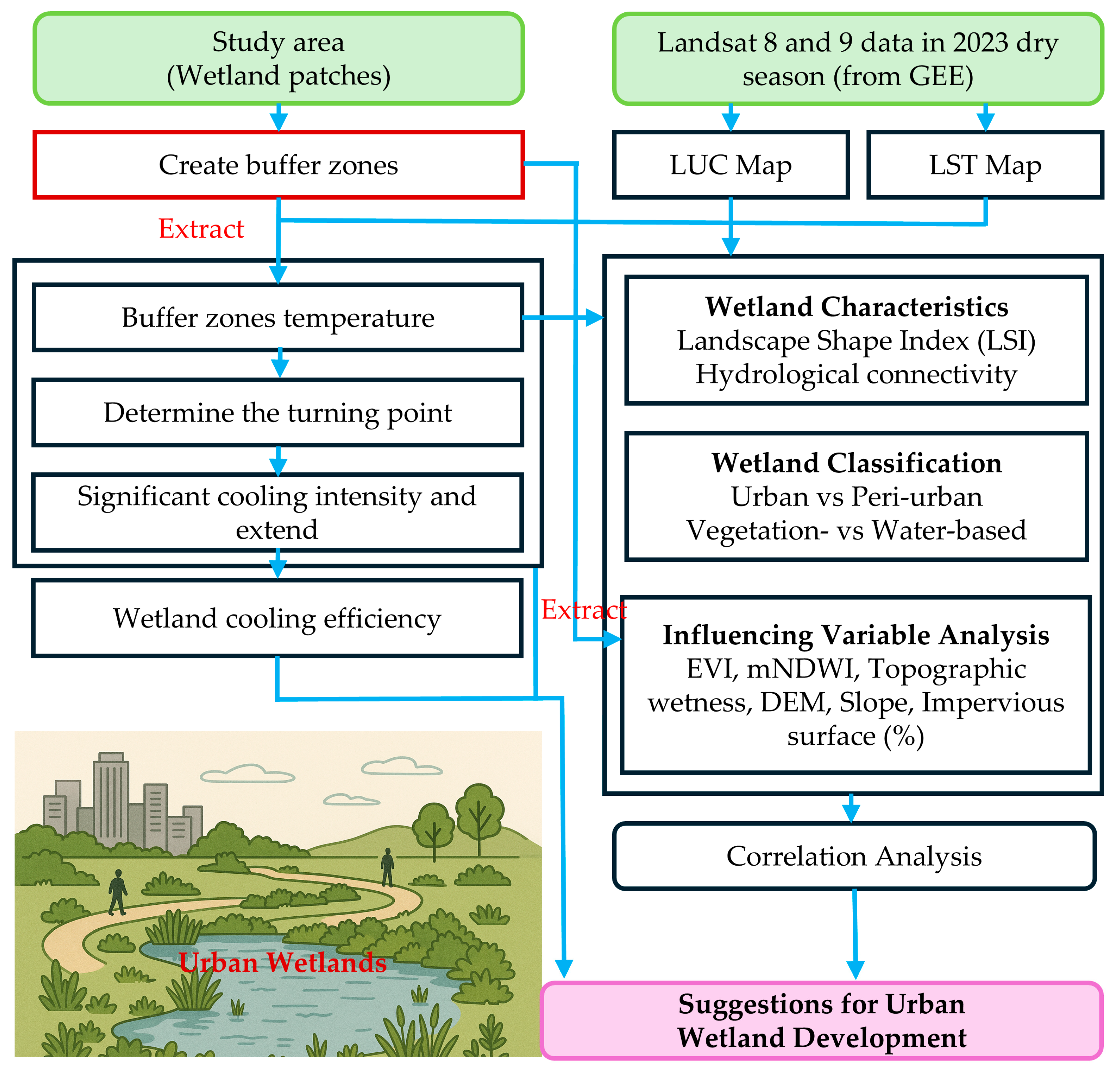
2. Materials and Methods
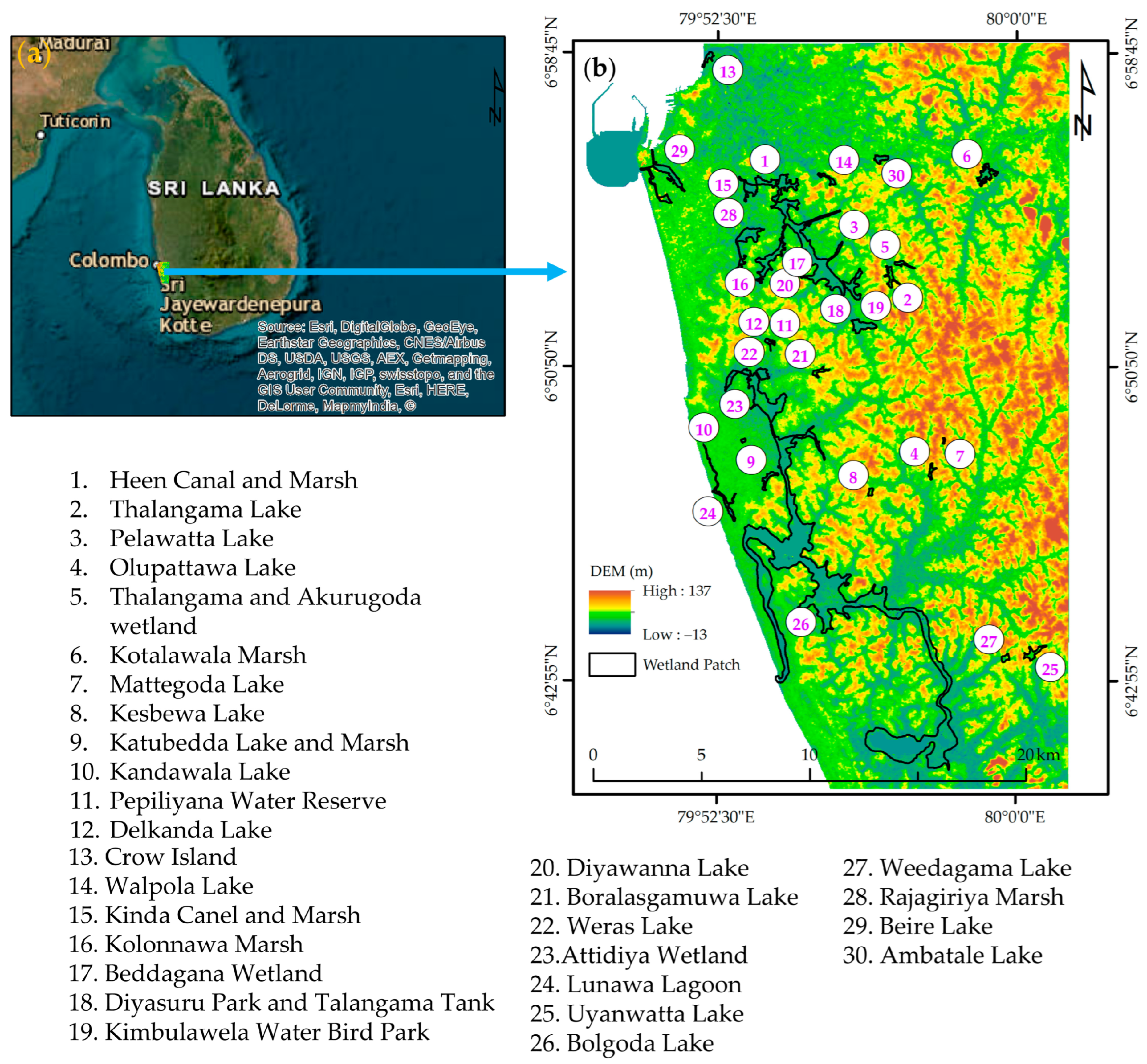
Figure 1 shows the schematic diagram of this study. This study used Landsat 8 and 9 data from the 2023 dry season for Colombo, Sri Lanka. We utilized 30 wetland patches and created buffer zones extending up to 1000 m to investigate the cooling effects of urban wetlands. Furthermore, this study incorporated wetland characteristics such as the Landscape Shape Index (LSI) and hydrological connectivity. We examined urban and peri-urban wetlands and vegetation-based and water-based wetland cooling performances, as well as carried out an influencing variable analysis to maximize the cooling effect of urban wetlands, providing suggestions for urban wetland development for urban planners and policymakers. Each step of the study is explained in Section 2.2, Section 2.3, Section 2.4, Section 2.5, Section 2.6, Section 2.7 and Section 2.8.

2.1. Study Area

Colombo City (Latitude: 6°55′37′′N, Longitude: 79°51′40′′E) is in the western coastal belt of Sri Lanka, within the wet zone of the country (Figure 2). Colombo is characterized by a tropical monsoon climate according to the Köppen climate classification system [74]. The city experiences a dry season with hot and humid conditions from December to February, while the wet season spans from May to September, bringing substantial rainfall [75]. The average annual rainfall in Colombo ranges between 2000 mm and 2500 mm, with a mean annual temperature of approximately 28 °C [75].
Colombo has faced significant issues due to rapid urban expansion and socio-economic growth, leading to the loss of green spaces, wetland degradation, and unplanned construction activities [65,66,67]. Such changes control the natural cooling processes of urban wetlands, intensifying the UHI effect and increasing flood risks. Although Colombo has a rich urban wetland ecosystem, inadequate urban planning and land use change have affected wetland sustainability and the well-being of its residents.

2.2. LUC Classification

We used Landsat 8 and 9 operational land imager (OLI) data to create a LUC map for the dry season in 2023 using the GEE [78,79]. To classify LUC for Colombo for the dry season in 2023, we considered five categories: (i) Impervious surfaces (ISs), comprising residential, commercial, and industrial areas and roads, the airport, and other infrastructure; (ii) Green Space 1 (GS 1), comprising vegetation and urban tree clusters; (iii) Green Space 2 (GS 2), comprising grasslands, shrubs, lawns, and agricultural areas; (iv) bare land, including open soil and undeveloped areas; and (v) water, including, rivers, lakes, channels, streams, and ponds. The Random Forest (RF) algorithm in the GEE was applied to create the map using 400 training points, divided into 80% for training and 20% for validation, with an overall accuracy of 92% for the map of 2023 [80]. We excluded the bare land area before the analysis due to its minimal representation.

2.3. LST Derivation

The Landsat 8 and 9 satellites are equipped with Thermal Infrared Sensor (TIRSs), which provide thermal infrared (TIR) data in two bands: Band 10 (10.60–11.19 µm) and band 11 (11.50–12.51 µm) [78]. LST derivation involves converting the digital numbers (DNs) of the TIRS bands into surface temperature values [65,81].
The LST map for the dry season in Colombo in 2023 was derived using the Mono-Window Algorithm (MWA), as recommended by the National Aeronautics and Space Administration (NASA) [39,82,83]. The MWA is a reliable and widely utilized approach for estimating the LST using thermal infrared data, such as a TIRS on Landsat [84,85]. Colombo experiences its dry season from December to February, with little rainfall and a relatively stable temperature. This stable climate is ideal for conducting LST analysis because it minimizes the influence of precipitation and cloud cover in the study area. According to data from the Colombo Meteorological Station [86], during the dry season in Colombo in 2023, the average maximum temperature was 33 °C, the average minimum temperature was 26 °C, the mean temperature was 29 °C, and the average rainfall was 250 mm. Equation (1) illustrates the derivation of the LST [65,83].
L S T = T b 1 + λ × T b ρ   l n ε
where LST is the Land Surface Temperature (Kelvin), Tb is the brightness temperature (Kelvin), obtained from satellite thermal band data, λ is the wavelength of the thermal band (meters), ϵ is the surface emissivity, and ln(ϵ) is the natural logarithm of the surface emissivity. Furthermore, ρ = h × c/σ, a constant derived from h—Planck’s constant, c—speed of light, or σ—the Boltzmann constant.

2.4. Extraction of Wetland Patches and Hydrological Connectivity

The wetland patches were all obtained through Google Earth images [87]. Thirty urban wetland patches were obtained. To understand the relationship between the hydrological connectivity of wetlands and the LST, the extracted wetland patches were categorized into two groups: “hydrologically connected wetlands (1)” and “hydrologically disconnected wetlands (0)”. This classification was conducted using hydrological network data from the Survey Department of Sri Lanka [88], Google Earth [87], and OpenStreetMap [89]. Based on this classification, 30 wetland patches were connected to at least one water channel, stream, or river, indicating their hydrological connectivity with wetlands. Numerous studies suggested that rich hydrologically connected wetlands assist in mitigating the UHI effect and ensure the long-term sustainability of the wetland [61].

2.5. Wetland Shape Index

Some studies have reported the connection between the size and shape of urban wetlands and their impact on the cooling effect [43,61]. However, substantial uncertainties remain regarding the extent of the cooling effects of urban wetlands. It needs to be understood which urban wetland configurations provide the best cooling effects, such as small or large areas or simple or complex shapes. This study examines the cooling effects of urban wetlands using the wetland area and Landscape Shape Index (LSI). The LSI was used to examine the cooling effect on the shape of the urban wetland, as shown in Equation (2) [43]. This analysis is crucial for understanding how urban wetland design and planning can maximize the cooling effect in urban environments.
L S I = P π × A 2
where LSI is the Landscape Shape Index of a wetland patch, P is the perimeter, and A is the area. The larger value of the LSI shows the more complex wetland shapes.

2.6. Assessment of the Cooling Extent, Intensity, and Efficiency of Urban Wetlands

To evaluate the cooling extent and intensity of urban wetlands, we created 50 buffer zones at 30 m intervals, extending up to 1000 m from the outer line of each wetland. The mean LST for each buffer was extracted by overlaying the buffer layer on the 2023 LST image. To determine the cooling extent, we extracted the mean LST of each buffer against its distance from the wetland and identified the first turning point in the LST, which is considered the cooling extent (m) of each wetland. Then, the total cooling area (ha) was calculated as the combined area of the buffers up to the first turning point. The cooling intensity (CI) was calculated using the following Equation (3). The cooling efficiency was identified as the ratio of cooling intensity to the cooling extent (°C/m) [61]. The threshold value of efficiency (TVoE) was identified using regression analysis at the slope change in the fitted logarithmic function between the wetland area (ha) and cooling intensity (°C) [47].
C I = M e a n   t e m p e r a t u r e   a t   F i r s t   t u r n i n g   p o i n t M e a n   T e m p e r a t u r e   o f   t h e   w e t l a n d

2.7. Urban Wetland Classification

In the context of urban and peri-urban wetlands, all wetlands were classified based on their distance from the urban core. Wetlands within 15 km of the urban core were identified as urban wetlands, while those <15 km were considered peri-urban wetlands based on the extent of urbanization in Colombo. Based on this classification, there were twenty-two urban wetlands and eight peri-urban wetlands (Table S1).
In the context of vegetation-based and water-based wetlands, the wetlands were determined based on the dominant type within each wetland patch. A wetland was categorized as water-based if the water area was < 70% of the wetland patch. Conversely, if vegetation covered < 70% of the wetland patch, it was classified as a vegetation-based wetland. Wetland patches were used to extract the area from the LUC map in 2023. These results were cross-checked using high-resolution imagery from Google Earth [87]. According to this classification, seventeen were water-based, and thirteen were vegetation-based wetlands (Table S2).

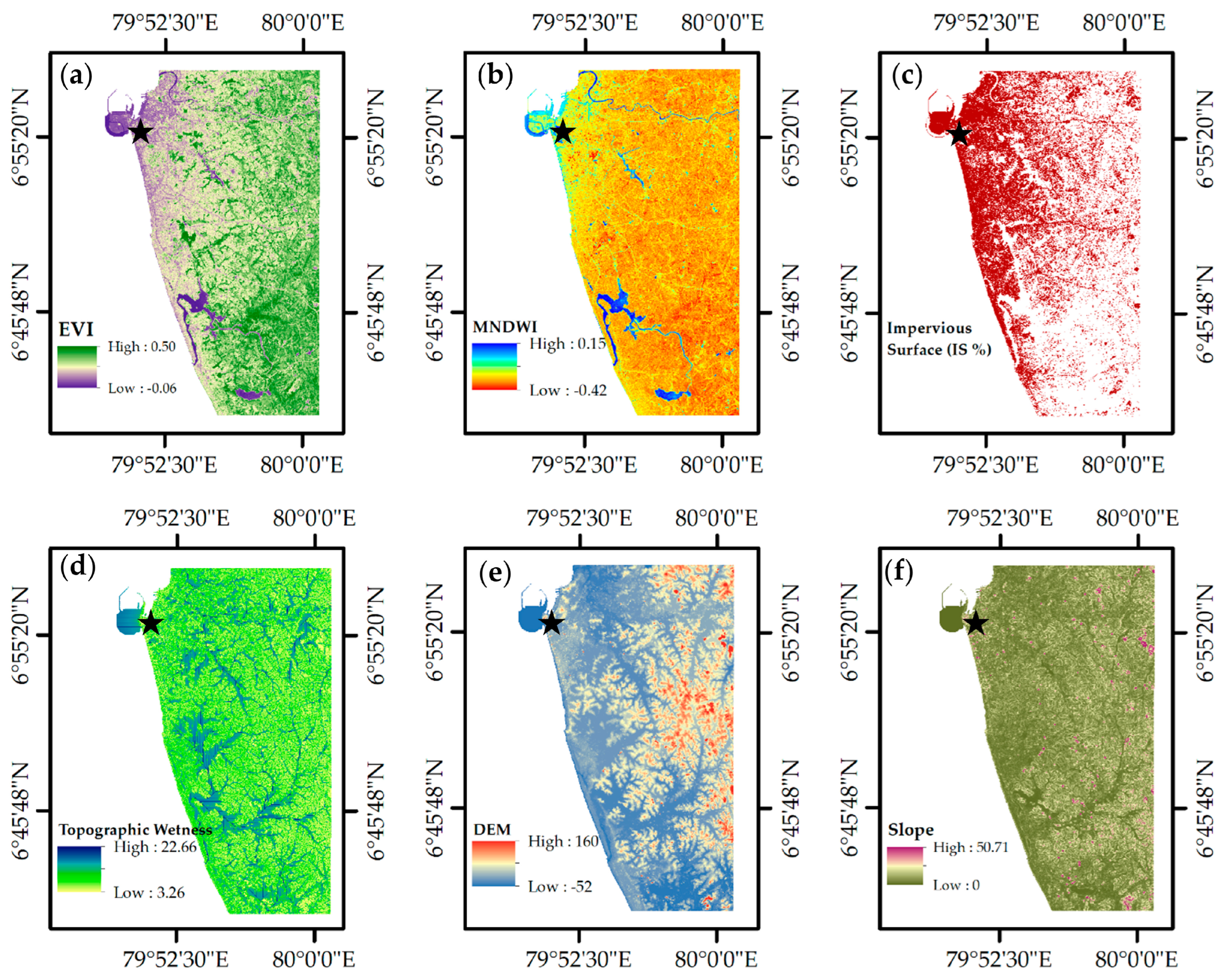
2.8. Influencing Variable Analysis

The Enhanced Vegetation Index (EVI) [90], Modified Normalized Difference Water Index (mNDWI) [91,92], topographic wetness [93,94], elevation [95], slope [1], and impervious surface area percentage (from a classified LUC map from 2023) have been identified as the influencing variables in this study (Figure 3). These variables are crucial as they capture the environmental and anthropogenic factors affecting the cooling effects of urban wetlands [1,47,61]. The mean value of each influencing variable for each wetland was extracted using the 1000 m buffer zone created. This approach comprehensively evaluates the spatial and environmental variables and provides a robust understanding of the changes in the cooling effects of urban wetlands and their conditions.

3. Results

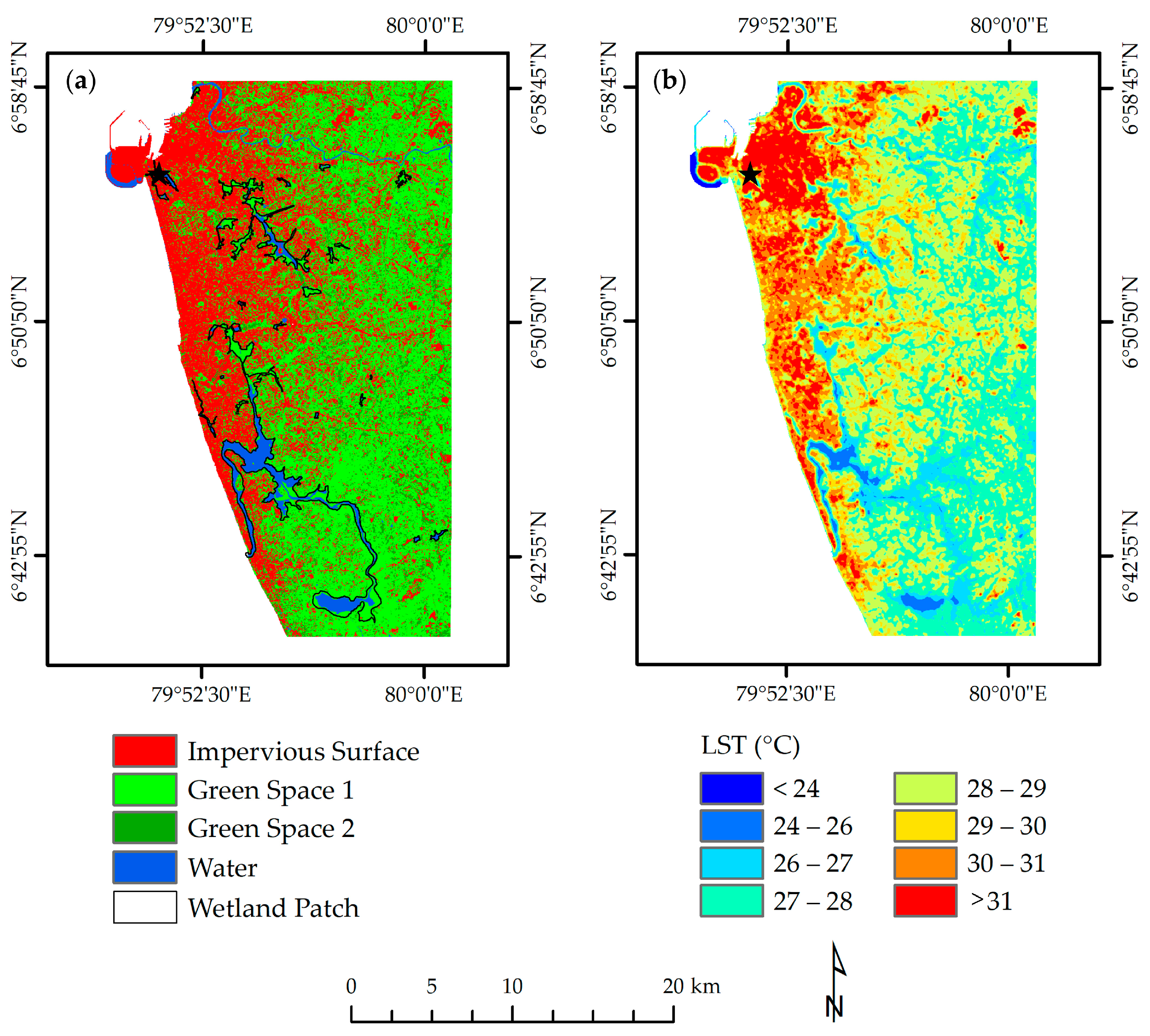
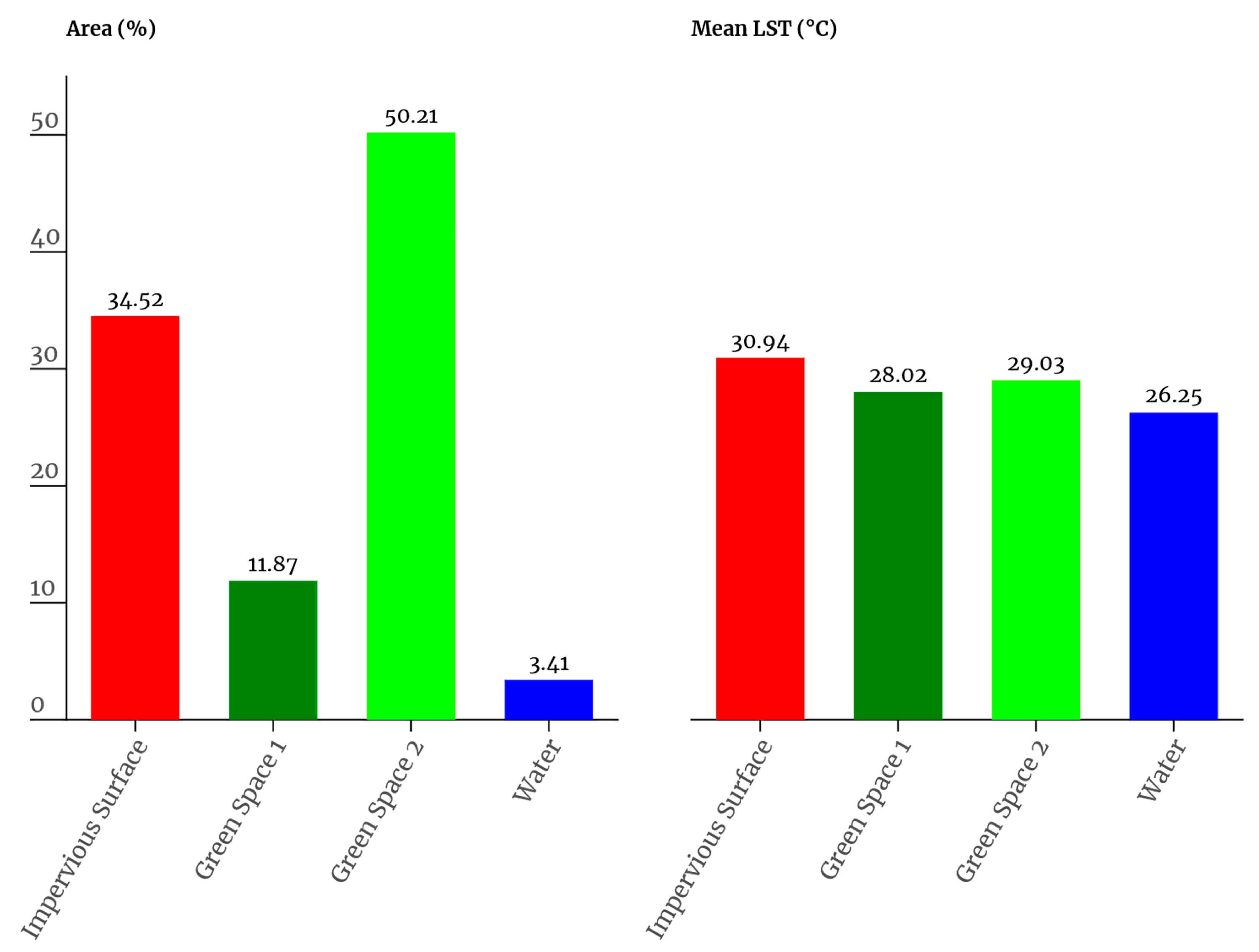
3.1. LUC and LST of the Colombo City

Figure 4 shows the LUC and LST maps of Colombo City in the dry season in 2023. The impervious surface areas and human activities were mainly concentrated along the coastal belt in the western and central parts of the city. The impervious areas have been expanding towards the north, east, and southern parts, consuming their natural vegetation and causing significant urban landscape changes. This expansion is not only changing the composition and configuration of the city but also threatening the existing urban wetlands.
Urban wetland areas are mainly concentrated in the central part of Colombo City, near the coastal belt, with some peri-urban wetlands located at a considerable distance from the city center (Figure 4a). The LUC maps reveal that urban wetlands in Colombo are significantly affected by encroachment from impervious surfaces. Notably, Green Space 1 and Green Space 2 are primarily concentrated in the eastern and southern parts of the city, with scattered patches observed around impervious surface areas in the central, western, southern, and northern parts of the city. Water areas are predominantly found in the western, middle, northern, and southern parts and surrounding urban wetlands.
The Landsat-derived LST was captured around 10:20:15 local time during the dry season in 2023. The results show that the LST ranged from 24.34 °C to 36.69 °C, with a mean LST of 29.42 °C (Figure 4b).
Figure 5 shows the area percentage (%) and the mean LST values (°C) of Colombo City in 2023. Three LUC categories—Green Space 1 (28.02 °C and 11.87%), Green Space 2 (29.03 °C and 50.21%), and water (26.25 °C and 3.41%)—are lower than the mean LST of the study area, indicating that these categories provide the urban cooling effect. In contrast, impervious surface areas indicate the highest mean LST (30.94 °C), exceeding the mean LST of the entire study area. Furthermore, these impervious surfaces (35%) of the total area significantly contribute to the intensification of the UHI effect in Colombo City.

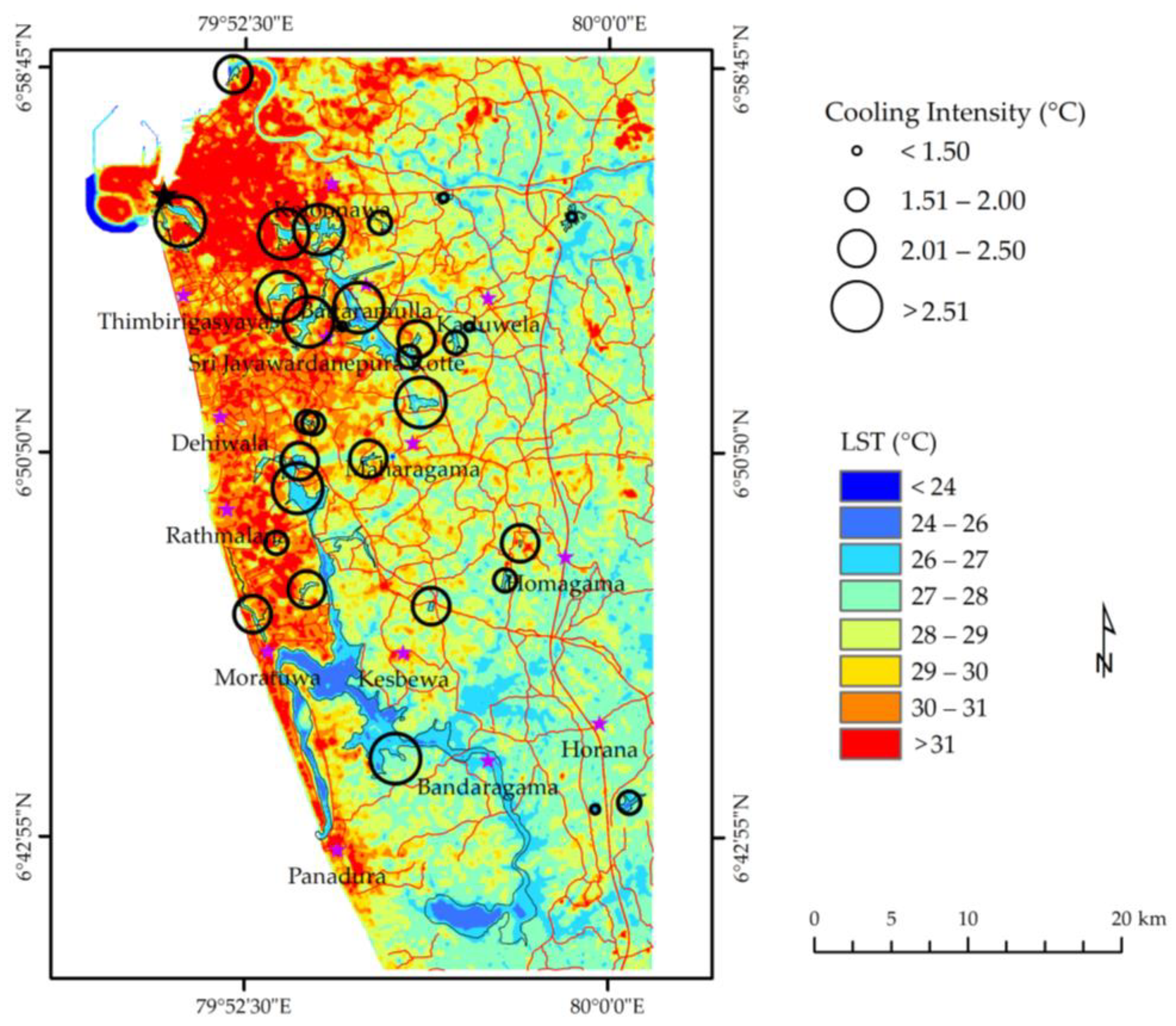
3.2. Cooling Effect of Urban Wetlands

Table 1 and Table S3 reveal the significant cooling potential of urban wetlands. The average cooling intensity was 2.17 ± 0.76 °C, with a range from 0.45 °C to 3.59 °C in the dry season in Colombo City. The cooling extent of the urban wetland varied from 120 to 450 m in the dry season, with an average of 285 ± 93.80 m. The average cooling efficiency of the urban wetlands was 0.82 ± 0.35 °C per 100 m and 2.52 ± 2.46 °C per hectare (ha) in the dry season. The TVoE of the urban wetland was 1.42 ha in Colombo (Figure 6). These results show the crucial role of urban wetlands in mitigating the UHI effect.
Furthermore, we gathered data on the wetland shape (LSI), hydrological connectivity, and distance to the urban core for all wetlands. The average LSI results of the urban wetlands were 2.54 ± 1.37, and the range varied from 1.09 to 6.97 (Table 1 and Table S3). The results indicate that the wetlands of Colombo City range from simple, compact shapes, such as near circular or square, to more irregular, fragmented shapes. These transformations from simple to complex shapes indicate increased urban landscape complexity due to the fragmentation of natural wetland areas, which are affected by urban expansion, roads, buildings, and other urban structures’ development.
Figure 7 shows the correlation coefficients (R) between the mean LST of urban wetlands and their associated characteristics. A negative correlation was shown between wetland areas and the mean LST of wetlands (R = −0.44) because urban wetlands act as natural cooling systems due to their high water content and vegetation, and they promote evapotranspiration and reduce the LST in urban areas. Conversely, the cooling intensity was positively correlated with the wetland area (R = 0.26) (Figure 7) and the wetland area with the LSI (R = 0.69) (Figure 7). The results suggest that wetlands have the potential to enhance urban cooling due to heat exchange and shading. More complex wetland shapes increase edge effects, promoting more significant interaction with the surrounding areas for cooling effects.
Figure 7 illustrates the correlation between the wetland area, turning distance, LSI, and cooling extent. The results reveal significant positive correlations (R = 0.99, R = 0.44, and R = 0.75, respectively), indicating that urban wetlands and more complexly shaped wetlands promote their cooling effects. In addition, the high R values suggest that the wetland size and shape (LSI) strongly control the cooling extent due to higher evapotranspiration, heat absorption, and thermal regulation capacity in urban wetlands. The positive LSI correlation with the cooling extent reveals that irregularly shaped wetlands with higher edge effects facilitate better microclimatic relations, promoting heat dissipation. These findings highlight the crucial role of urban wetlands and their impact on urban thermal regulation.
The results indicate that the distance to the coast shows negative correlations with three critical factors related to urban wetland cooling, namely the turning point temperature (R = −0.72), cooling intensity (R = −0.59), and LSI (R = −0.32) (Figure 7). These negative values suggest that when wetlands are located far from the coastal area, their turning point temperature increases, and cooling intensity and LSI decrease. The reason for this can be explained by the influence of coastal proximity on wetland microclimates. Coastal areas typically benefit from moderated temperatures due to the cooling effects of large water bodies, enhancing humidity and evaporative cooling. Urban wetlands near the coast can better maintain lower temperatures because of the continuous coastal influence. However, when wetlands are located far from the coastal area, they lose this direct coastal cooling effect. The positive relationship between the distance to the coast and the distance to the urban core (R = 0.49) indicates that wetlands located away from the coast are closer to densely built urban areas. In Colombo, Sri Lanka, coastal areas are often protected under the Coastal Conservation Act, while urban areas expand inland (Figure 4a). Wetlands near urban cores show reduced cooling effects due to more heat-absorbing surfaces, such as roads and buildings, and less natural vegetation.
The results show positive correlations with the cooling intensity and turning point temperature and wetlands’ mean LST with the turning point temperature (R = 0.68 and R = 0.61, respectively) (Figure 7), indicating that wetlands enhance their cooling effect to this critical threshold and that the mean LST of wetlands influences their cooling intensity. These findings reveal the critical role of urban wetlands, emphasizing their significant role in urban thermal management.

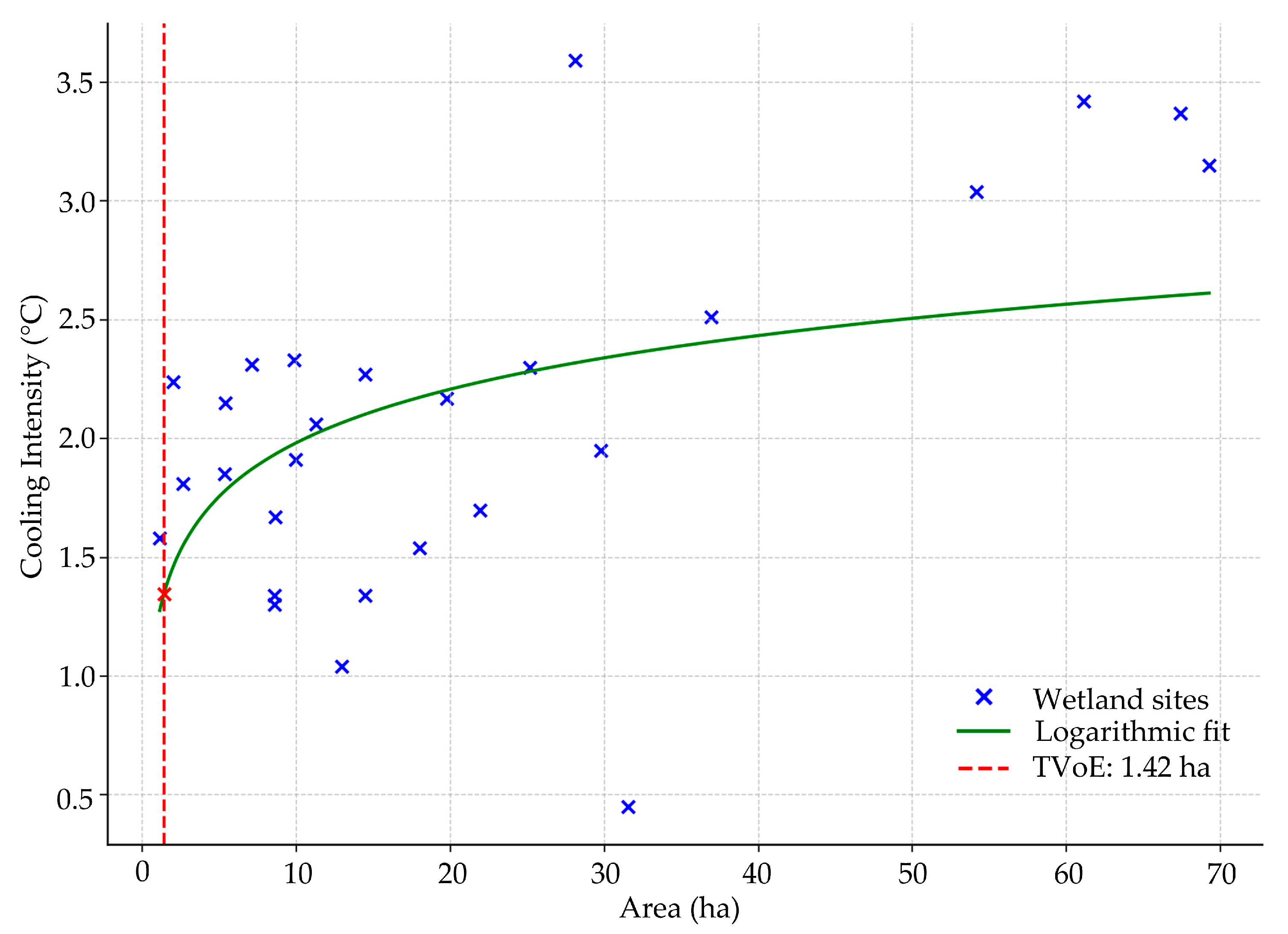
3.3. Cooling Intensity of the Urban Wetlands

Figure 8 and Table S3 show the LST and cooling intensity of the urban wetlands in Colombo City. The cooling intensity of the urban wetlands in Colombo City varies across four categories. Nine wetlands provide a cooling intensity >2.51 °C, eight wetlands provide the range of 2.01–2.50 °C, another eight wetlands offer a cooling intensity between 1.51 and 2.00 °C, and five wetlands contribute > 1.50 °C of cooling effect. Within the >2.51 °C cooling intensity category, the urban wetlands show an average wetland area of 283 ha and an average cooling extent covering an area of 739 ha. The average LSI for this category is 3.6. The 2.01–2.50 °C category shows an average wetland area of 11 ha, an average covering area of 96 ha, and an average LSI of 2.1. The 1.51–2.00 °C category reveals an average wetland area of 12 ha, an average covering area of 95 ha, and the average LSI for this category is 2.0. The fourth category is <1.5 °C, showing an average wetland area of 15 ha, an average cooling extent of 70 ha, and an average LSI of 1.9 (Figure 8 and Table S3).
The results demonstrate the significant influence of the wetland area and LSI on the wetland cooling intensity. For instance, in the categories 2.01–2.50 °C and 1.51–2.00 °C, the average wetland areas are 11 ha and 12 ha, respectively, with cooling extents of around 96 ha and 95 ha, respectively (Figure 8 and Table S3). This slight change in the cooling extent is due to the minor variation in the LSI values. This trend is particularly noticeable in categories >2.51 °C and >1.5 °C, indicating the connection between the wetland area, cooling extent, and LSI.

3.4. Cooling Effect of Urban and Peri-Urban Wetlands

The relationship between the wetland area and mean LST for urban and peri-urban wetlands showed a negative correlation (R = −0.33 and R = −0.57, respectively) (Tables S4 and S5). These results reveal that peri-urban wetlands provide greater cooling effects compared to urban wetlands. Furthermore, urban and peri-urban wetlands showed positive relationships between wetland areas and cooling intensity with cooling extent. For urban wetlands, the relationships were R = 0.44 and R = 0.56 (urban wetlands), respectively, and for peri-urban wetlands, the relationships were R = 0.57 and R = 0.61, respectively (Tables S4 and S5). The results further indicate that peri-urban wetlands have higher cooling effects compared to urban wetlands. The results also indicate a relationship between the cooling intensity and the LSI in urban wetlands (R = 0.58) compared to peri-urban wetlands (R = 0.45) (Tables S4 and S5), indicating that urban planners should consider the role of the LSI and its connection with cooling intensity when designing urban wetlands.

3.5. Cooling Effects of Urban Wetland Types

The results revealed a negative relationship between the wetland area and mean LST in water- and vegetation-based wetlands (R = −0.50 and R = −0.43, respectively) (Tables S6 and S7). Furthermore, evaporation from water areas consumes heat from the surrounding environment. In contrast, vegetation-based wetlands mainly depend on shade and transpiration, which are less effective at absorbing and scattering heat. As a result, water-based wetlands contribute significantly to cooling fragmented urban areas.
The results indicate a positive relationship between the cooling intensity and LSI (R = 0.71 and R = 0.29), cooling extent and wetland area (R = 0.99 and R = 0.87), and cooling intensity and cooling extent (R = 0.52 and R = 0.71) for water-based and vegetation-based wetlands, respectively (Tables S6 and S7). The results further indicate that the relationships between the cooling intensity and LSI and cooling extent and wetland area are stronger in water-based wetlands compared to vegetation-based wetlands, indicating that the spatial configuration of water-based wetlands improves heat dissipation in fragmented urban landscapes. In contrast, the relationships between the cooling intensity and cooling extent are more powerful in vegetation-based wetlands compared to water-based wetlands because of their broader spatial coverage and potential to impact microclimates over larger areas via shade and wind moderation.

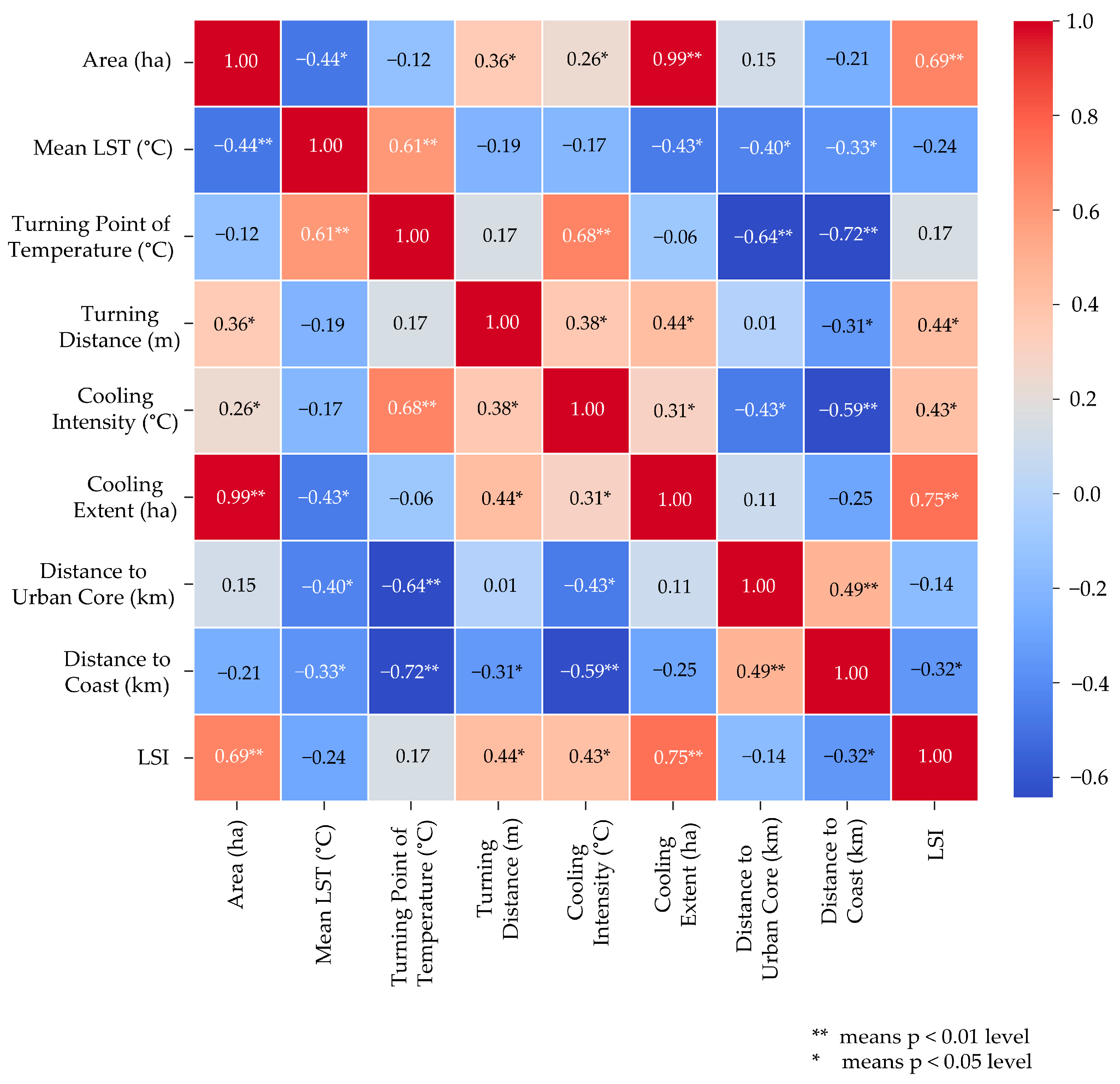
3.6. Influencing Variables of Cooling Effect

Table 2 and Table S8 show the variables that influence the cooling effects of urban wetlands. The dependent variable was the mean LST of each wetland. The independent variables were the EVI, MNDWI, topographic wetness, DEM, slope, and impervious surface area (%) (see Table S8). Hydrological connectivity (Table S3) was excluded from the analysis because all wetlands were connected to at least one water canal or river in the study area.
The cooling effects of urban wetlands positively influenced the EVI (R2 = −0.64 ± 0.24) and MNDWI (R2 = 0.12 ± 0.44) (Table 2). The results indicate the critical roles of green space and water areas in controlling the cooling effects of urban wetlands. Our study revealed that the EVI controls the cooling effect of 64%, with a 24% variation, indicating high and low vegetation presence from the edge of the wetlands, indicating cooling effects (Table 2). The positive value of the MNDWI indicates that 12% of the area contributes less effectively to reducing the temperature in the surrounding environment and that 44% shows high variability because of significant changes in the surrounding urban landscape characteristics. Urban processes increase the impervious surfaces and reduce water availability, declining the wetlands’ cooling effect from the edge of wetlands and vice versa.
The topographic wetness indicates a negative relationship (−30% with −12% low variability), emphasizing the consistent role of topographic wetness in stabilizing microclimates (Table 2). In contrast, the positive value of DEM (57%) with variability (20%) suggests the existence of high- and low-lying areas, indicating the cooling and warming effects (Table 2). The wetland areas are mainly located at lower elevations compared to the surrounding urban areas, and the elevation gradient from the wetlands to relatively higher elevated urban landscapes plays a vital role in regulating the cooling effects of urban wetlands. Generally, lower elevations are more prone to heat retention. The slope and impervious surface (%) also show positive values (the slope contributes 25%, and impervious surfaces contribute 58%, with 12% and 22% variability, respectively) (Table 2). The lower slope value indicates that most wetlands are in relatively flat terrain, which may reduce the natural cooling effects. The impervious surface (%) reveals substantial urban development surrounding the wetland landscape, and the variability suggests that highly less urbanized areas encompass wetland areas.

4. Discussion

4.1. Influence of Wetland Characteristics on Urban Cooling

Urban wetland design and optimization are practical strategies to mitigate the UHI effect in cities. Consequently, urban wetlands have received significant attention from urban planners and policymakers, especially their design and functionality, maximizing cooling effects and ecosystem services. For this, several critical questions should be clarified:
(1)
Where should urban wetlands be established—within urban cores or peri-urban areas?
(2)
What should the optimal size and shape be (simple or complex configuration)?
(3)
What type of wetland is most suitable—water- or vegetation-based wetlands?
(4)
How does the surrounding urban landscape influence the cooling intensity of wetlands?
(1) 
Wetland location
The location of urban wetlands within urban cores or peri-urban areas remains a critical consideration in landscape design and urban planning. Several studies revealed the fundamental role of wetlands in reducing UHI effects through evapotranspiration and heat absorption [43,96,97]. However, the degree of cooling effectiveness differs based on the location [47], landscape composition [61], shape [43], urban morphology [98,99], distance to the urban core, and distance to the coast. From the viewpoint of landscape ecology, peri-urban wetlands provide a higher cooling intensity due to their considerable spatial extent, lower fragmentation, higher connectivity with other natural lands, and reduced exposure to anthropogenic heat sources [47,100,101,102]. Studies have reported that the wetland size and landscape configuration (shape) determine the cooling efficiency [102]. Wetlands in peri-urban areas have substantial vegetative biomass and higher water availability, enhancing the evaporative cooling of the wetlands [61,103,104]. Conversely, despite their limited extent, wetlands in urban core areas play a critical role in urban cooling within dense urban environments [43].
The cooling intensity of wetlands in urban core areas contributes to decreasing the surrounding temperature (see Section 3.2). The LSI influences the cooling intensity, and higher LSI values of wetlands in urban core areas increase the edge effects that enhance cooling efficiency [61,105]. Therefore, establishing a multi-scale wetland system in urban core areas with higher hydrological connectivity is ideal for expanding cooling effects [104,106]. Urban core wetlands should be strategically planned to maximize the cooling effects of connectivity with the other natural lands and establish green corridors with rich hydrological connectivity [20]. In contrast, peri-urban wetlands should be prioritized for large-scale cooling benefits and regional climate resilience [61,98]. Our study revealed that urban wetlands are vital for localized microclimate sustainability, while peri-urban wetlands offer higher thermal regulation. Considering spatial heterogeneity, connectivity, and land use policies, a balanced, integrated wetland strategy can maximize the cooling benefits in the urban core (<15 km) and peri-urban (>15 km) areas (see Section 2.7).
(2) 
Wetland size and shape
The optimal size and shape of urban wetlands are critical to maximize their cooling benefits [61,106,107]. The results of our study revealed that medium and larger-sized wetlands with more complex shapes (higher LSI values) show more powerful cooling effects due to edge effects, higher evapotranspiration, and microclimatic regulation. Interconnected multi-scale wetlands rather than small, isolated wetlands promote heat dissipation and create microclimatic zones with a lower LST in urban areas [47,99]. For example, studies in cities such as Copenhagen [105] and cities in Northeast China [61] such as Beijing [108], Hangzhou [99], Chengdu [47], and Shenzhen [109] revealed that urban wetlands reduce surrounding temperatures by 2–3 °C, indicating urban wetlands positively impacting urban cooling. Similarly, our study revealed that the positive correlation between wetland size and cooling extent corresponds with the results in the inland basin and subtropical urban cities [47,61].
The complexity of the wetland shape plays a significant role in urban cooling [61]. Higher LSI values indicate irregularly shaped wetlands with more edge effects, facilitating heat exchange [47,108]. Several studies reported this phenomenon: wetlands with complex shapes revealed a broader cooling capacity compared to compact, circular wetlands in China [47,61,110] and high-latitude cities [105]. Our study showed that wetlands with complex configurations had higher cooling effects (see Section 3.2). However, excessive fragmentation may reduce urban wetlands’ connectivity and cooling efficiency. Urban planners should prioritize an optimal wetland design with a balanced size, shape complexity, and connectivity. Our study showed that wetlands between 10 and 50 ha with higher shape complexity (LSI 2-4) offer significant cooling effects of urban wetlands.
(3) 
Wetland type
Water- and vegetation-based wetlands revealed that water-based wetlands provide more powerful cooling effects due to their higher specific heat capacity and evaporative cooling possibility [69,106,111,112]. However, integrated wetlands require the consideration of water- and vegetation-based wetlands, spatial configuration, and hydrological connectivity (see Section 3.4). They absorb and release heat at different times of the day and in different seasons. For instance, Xue et al. (2019), Wu et al. (2021), and Cheng et al. (2019) reported that wetlands with a heterogeneous structure can provide more consistent cooling effects [47,61,110]. Hydrological connectivity further influences the cooling effects of urban wetlands [105,106]. Behampore Town (India) and Chengdu (China) revealed that wetlands with better hydrological connectivity show enhanced cooling effects and sustainability of the wetlands [47,113]. These results correspond with our results, indicating the importance of spatial planning in integrating wetlands for urban cooling (see Section 3.4). In addition, the water depth of wetlands plays a critical role in urban cooling [114,115]. Urban wetlands with a deep water capacity can store more heat during the daytime and release heat slowly at nighttime [116].
In contrast, shallow water wetlands store heat and cool faster due to higher evaporation rates, suggesting that an optimal balance of wetland depth should be maintained based on local climatic conditions and urban configurations [61,100]. In temperate climate zones [46,61,66,117], water-based wetlands showed more substantial cooling effects in the daytime, and mixed wetlands provide significant cooling benefits in tropical climates by balancing evaporation and shading. Therefore, urban planners should focus on integrating water- and vegetation-based wetlands with enhanced spatial and hydrological connectivity rather than prioritizing a singular wetland type.
(4) 
Urban landscape
The cooling intensity of urban wetlands depends on the surrounding urban landscape and is controlled by urban expansion, road network development, suburban growth, hydrological modifications, and topographic factors [47,61]. Many studies reported that the EVI and mNDWI control UHI effects [102,118,119]. The higher EVI and mNDWI values indicate more vegetation and water areas that mitigate the UHI effects [99,106,110]. Studies have shown negative correlations between the EVI, mNDWI, and LST. Our study reveals a negative relationship between these variables and the mean LST of wetlands (see Section 3.6). The observed low negative relationships indicate the fragmentation of wetland connectivity due to urban development and variations in green space and water availability in the surrounding landscape.
Topographic wetness and DEM are important variables for wetland cooling effects [120,121,122]. Lower-elevation areas often correspond with wetland basins, possessing the ability to retain heat due to decreased airflow and higher relative humidity. Studies have shown that topographic wetness stabilizes microclimate conditions and that the negative relationship with the mean LST of the wetlands in Colombo suggests that the cooling effects of urban wetlands can be enhanced by topographic wetness. Therefore, urban planners should give more consideration to these factors when locating wetlands in urban areas.
The impervious surface area modifies the cooling effects of urban wetlands [61,62,102]. The expansion of impervious surface areas improves heat absorption, reduces soil permeability, and intensifies surface runoff, reducing wetland functionality [101,106]. In addition, the changes in spatial configuration in the urban landscape impact the thermal interactions of the wetlands [81,101]. Urban wetlands within built environments experience reduced cooling efficiency due to heat advection and anthropogenic heat sources [46,110]. The heat advection in urban areas indicates when the warm temperature in surrounding impervious surface areas moves into cooler spaces, such as urban wetlands, affecting their natural cooling effect.
Moreover, our study reveals that contiguous and interconnected wetlands increase the cooling intensity of the wetlands and that dense green spaces and water areas further expand the cooling effects of Colombo’s wetlands. Urban planners and designers should focus on strategic urban planning, integrating urban wetlands with sustainable land use policies. Finally, integrating influencing variables into locating and designing urban wetlands will further maximize urban cooling, particularly in rapidly urbanizing coastal cities.

4.2. Implication for Urban Wetland Design

In general, urban wetlands have lower temperatures compared to non-wetland areas [106]. The cooling effect is mainly characterized by evaporation from wetlands, which increases air humidity and reduces the ambient temperature, which plays a major role in thermal buffering in urban areas, creating microclimate environments [61,110]. The results of this study confirm that urban wetlands in the coastal city of Colombo provide a cooling effect during the dry season. Compared with previous studies in inland cities such as Chengdu (Southwest China) [47], Changchun, Jilin City (Northeast China) [61], and Copenhagen [105], the results of this study indicate that the cooling effect of urban wetlands in Colombo was impacted by various factors, namely the area, extent (m), shape (LSI), hydrological connectivity, covering area (ha), distance to urban core (km), and distance to coast (km) and its spatial context—whether located in urban or peri-urban areas or wetland-type water-based or vegetation-based wetlands. Among these factors, our study indicates that the wetland size is the primary factor in explaining the cooling effect (see Section 3.2 and Figure 6). The TVoE of urban wetlands in Colombo was 1.42 ha (Figure 6), and this effective area is highly connected with the wetland shape, location, and wetland type. Our study further reveals that wetlands with more complex shapes enhance the cooling efficiency in coastal urban areas. In addition, hydrological connectivity also plays a pivotal role in the cooling effectiveness of these wetlands.
Urban planners have significant challenges due to the limited availability of urban space and the esthetic value of wetlands, as well as some urban wetlands that are strongly conserved by acts and regulations due to high biodiversity. Wetland conservation and restoration planning in Colombo aims to maintain climate resilience and enhance disaster risk management. Urban wetland protection in Colombo is governed by policies established by the Department of Wildlife Conservation under the Fauna and Flora Protection Ordinance, No. 2 of 1937 [123], alongside regulations from the Ministry of Environment [124], the Central Environmental Authority [125], and the Urban Development Authority [126]. The RAMSAR wetland management strategies and the Metro Colombo Urban Wetland Status Report from 2021 further support the protection of urban wetlands in Colombo [73,127]. To maximize the benefits of urban wetlands, these policies and strategies must be effectively integrated with cross-sectoral policies encompassing health, transport, and agriculture. Community-based urban wetland conservation practices are essential for enhancing wetland cooling effects, protecting biodiversity, and mitigating the impacts of extreme weather events in Colombo.
However, understanding the optimal wetland size is crucial to reducing the UHI effect in urban areas. Studies have shown that larger wetlands increase the cooling effects [47,101]; however, this cooling effect is reduced beyond a certain threshold [61,102]. This threshold may vary across cities due to climate, urbanization, influencing factors, and urban landscape differences. For example, the thermal threshold value of wetlands (TVoE) is 1.12 ha in Copenhagen [105], 5.25 ha in Shenzhen [109], 0.30 ha in Nanning [128], 0.55 ha in the Pearl River Delta [102], and 1.47 ± 0.34 ha in Chengdu [47]; the TVoE of our study was 1.42 ha.
In addition, urban wetland planners should consider construction costs and the trade-offs between cooling effects and combined wetland ecosystem services [1,129]. Moreover, our study emphasizes the significant role of small- and medium-sized wetlands in advancing urban cooling, especially in limited land areas in urban areas (Table S3). Finally, the threshold value is a crucial reference for effective urban wetland planning and design in Colombo.
Analysis of the influencing variables of all wetlands indicated that the topographic wetness surrounding these wetlands had negative values (see Section 3.6, Table 2). This negative correlation suggests that the moisture condition of the surrounding wetlands is crucial for designing effective wetlands in urban areas. Many studies revealed that the hydrological connectivity and topographic wetness determine the wetland water renewal and hydrological functions within wetlands [61,128].

4.3. Limitations and Future Directions

This study has several limitations. First, the 30 m resolution of Landsat 8 and 9 OLI/TIRS images limits their application in landscape planning. Second, the land cover data from Google Earth challenges the recognition of small wetland patches via visual interpretation. Future studies should consider high-resolution images and smaller wetland patches for further studies. The above limitations may impact the accuracy of determining the minimum wetland area, affecting the urban cooling intensity effect. Third, thermal cycling in urban wetlands (the absorption and scattering) should be examined. The impact of urbanization on urban wetlands’ cooling effect needs further exploration, such as the spatial-temporal changes in the urban cooling effect due to the urban processes in cities. Our study mainly concentrates on urban wetland areas and their shape and influencing factors. However, the cooling effect is highly complex and impacted by multiple factors. Our study may not use all the influencing factors, indicating the need for comprehensive future studies considering building heights, urban form, heat fluxes, wind speed, the water depth of the wetland, water connectivity frequency, and seasonal and diurnal variations. Future studies should consider long-term climate simulations and multi-variable assessments to optimize wetland placement for urban sustainability.

5. Conclusions

This study examined the cooling effects of urban wetlands in mitigating UHI effects in the coastal city of Colombo. The results indicate that wetlands provide significant urban cooling during the dry season, which is influenced by spatial factors such as the wetland size, LSI, hydrological connectivity, and surrounding urban landscapes.
Urban wetlands in Colombo show a substantial cooling efficiency (0.82 ± 0.35 °C per 100 m), indicating a relationship between the wetland size and cooling intensity. The TVoE was 1.42 ha on Colombo’s wetlands. Therefore, strategically establishing wetlands in urban areas offers a practical guide to decreasing the UHI effect. Hydrological connectivity is crucial for maintaining the wetland cooling efficiency in highly urbanized areas. The wetland surrounding the landscape also plays a significant role—wetlands in high-degree impervious surface areas showed more substantial urban cooling, while influencing factors such as the EVI, MNDWI, topographic wetness, DEM, slope, and impervious surface percentage control the cooling effect of the wetlands. The results further indicate that adjacent connected, cluster-wise wetlands with substantial green spaces and water areas around the wetland landscape expanded the cooling effect.
Our study suggests the need for integrated, hydrologically connected wetlands with a mix of vegetation and water areas in urban planning to enhance urban thermal comfort. Finally, this evidence-based approach helps urban designers, policymakers, and climate adaptation planners optimize urban wetlands and their cooling effects for future city designs.

Supplementary Materials

The following supporting information can be downloaded at: https://www.mdpi.com/article/10.3390/rs17111919/s1, Table S1: Urban and peri-urban wetlands; Table S2: Vegetation and Water based wetlands; Table S3: Major characteristics of urban wetlands; Table S4: Correlation coefficients for urban wetlands (R); Table S5: Correlation coefficients for peri-urban wetlands (R); Table S6: Correlation coefficients for water-based wetlands (R); Table S7: Correlation coefficients for vegetation-based wetlands (R); Table S8: Relationship between the mean LST of each wetland with influencing variables (R2).

Author Contributions

Conceptualization, D.A.; methodology, D.A.; software, D.A.; validation, D.A. and Y.M.; formal analysis, D.A.; investigation, D.A., Y.M., N.S.K.H., C.M.M.B., R.K.S. and S.L.J.F.; resources, D.A.; data curation, D.A.; writing—original draft preparation, D.A.; writing—review and editing, D.A., Y.M., N.S.K.H., C.M.M.B., R.K.S. and S.L.J.F.; visualization, D.A.; supervision, Y.M.; funding acquisition, D.A. All authors have read and agreed to the published version of the manuscript.

Funding

This research was supported by the Japan Society for the Promotion of Science (JSPS) through a Postdoctoral Fellowship (Grant No. 24KF0178) awarded to Darshana Athukorala and JSPS Grant No. 24K04416.

Data Availability Statement

The original contributions presented in the study are included in the article; further inquiries can be directed to the corresponding author.

Conflicts of Interest

The authors declare no conflicts of interest.

Abbreviations

UHIUrban heat island
LUCLand Use/Cover
LSTLand Surface Temperature
GEEGoogle Earth Engine
EVIEnhanced Vegetation Index
mNDWIModified Normalized Difference Water Index
TVoEThreshold value of efficiency
TIRThermal infrared
COP13Conference of the Parties to the Ramsar Convention on Wetlands
LSILandscape Shape Index
DEMDigital elevation model
SRTMShuttle Radar Topography Mission
OLIOperational land imager
ISImpervious surfaces
GS 1Green Space 1
GS 2Green Space 2
RFRandom Forest
TIRSThermal Infrared Sensor
DNsDigital numbers
MWAMono-Window Algorithm
NASANational Aeronautics and Space Administration
CICooling intensity

References

  1. Athukorala, D.; Murayama, Y.; Bandara, C.M.M.; Lokupitiya, E.; Hewawasam, T.; Gunatilake, J.; Karunaratne, S. Effects of Urban Land Change on Ecosystem Service Values in the Bolgoda Wetland, Sri Lanka. Sustain. Cities Soc. 2024, 101, 105050. [Google Scholar] [CrossRef]
  2. Athukorala, D.; Estoque, R.C.; Murayama, Y.; Matsushita, B. Impacts of Urbanization on the Muthurajawela Marsh and Negombo Lagoon, Sri Lanka: Implications for Landscape Planning towards a Sustainable Urban Wetland Ecosystem. Remote Sens. 2021, 13, 316. [Google Scholar] [CrossRef]
  3. Liang, X.; Guan, Q.; Clarke, K.C.; Liu, S.; Wang, B.; Yao, Y. Understanding the Drivers of Sustainable Land Expansion Using a Patch-Generating Land Use Simulation (PLUS) Model: A Case Study in Wuhan, China. Comput. Environ. Urban Syst. 2021, 85, 101569. [Google Scholar] [CrossRef]
  4. Lawler, J.J.; Lewis, D.J.; Nelson, E.; Plantinga, A.J.; Polasky, S.; Withey, J.C.; Helmers, D.P.; Martinuzzi, S.; Penningtonh, D.; Radeloff, V.C. Projected Land-Use Change Impacts on Ecosystem Services in the United States. Proc. Natl. Acad. Sci. USA 2014, 111, 7492–7497. [Google Scholar] [CrossRef]
  5. Herold, M.; Goldstein, N.C.; Clarke, K.C. The Spatiotemporal Form of Urban Growth: Measurement, Analysis and Modeling. Remote Sens. Environ. 2003, 86, 286–302. [Google Scholar] [CrossRef]
  6. Dewan, A.M.; Yamaguchi, Y.; Rahman, M.Z. Dynamics of Land Use/Cover Changes and the Analysis of Landscape Fragmentation in Dhaka Metropolitan, Bangladesh. GeoJournal 2012, 77, 315–330. [Google Scholar] [CrossRef]
  7. Mosammam, H.M.; Nia, J.T.; Khani, H.; Teymouri, A.; Kazemi, M. Monitoring Land Use Change and Measuring Urban Sprawl Based on Its Spatial Forms: The Case of Qom City. Egypt. J. Remote Sens. Sp. Sci. 2017, 20, 103–116. [Google Scholar] [CrossRef]
  8. Tan, R.; Liu, Y.; Liu, Y.; He, Q.; Ming, L.; Tang, S. Urban Growth and Its Determinants across the Wuhan Urban Agglomeration, Central China. Habitat Int. 2014, 44, 268–281. [Google Scholar] [CrossRef]
  9. Rimal, B.; Zhang, L.; Keshtkar, H.; Wang, N.; Lin, Y. Monitoring and Modeling of Spatiotemporal Urban Expansion and Land-Use/Land-Cover Change Using Integrated Markov Chain Cellular Automata Model. ISPRS Int. J. Geo-Inf. 2017, 6, 288. [Google Scholar] [CrossRef]
  10. UN-Habitat. World Smart Cities Outlook 2024; United Nations Human Settlements Programme: Nairobi, Kenya, 2024. [Google Scholar]
  11. United Nations Human Settlements Programme (UN-Habitat). New Urban Agenda; United Nations: New York, NY, USA, 2017; ISBN 978-92-1-132731-1. [Google Scholar]
  12. Gao, J.; O’Neill, B.C. Mapping Global Urban Land for the 21st Century with Data-Driven Simulations and Shared Socioeconomic Pathways. Nat. Commun. 2020, 11, 2302. [Google Scholar] [CrossRef]
  13. D’Amour, C.B.; Reitsma, F.; Baiocchi, G.; Barthel, S.; Güneralp, B.; Erb, K.H.; Haberl, H.; Creutzig, F.; Seto, K.C. Future Urban Land Expansion and Implications for Global Croplands. Proc. Natl. Acad. Sci. USA 2017, 114, 8939–8944. [Google Scholar] [CrossRef] [PubMed]
  14. Simkin, R.D.; Seto, K.C.; McDonald, R.I.; Jetz, W. Biodiversity Impacts and Conservation Implications of Urban Land Expansion Projected to 2050. Proc. Natl. Acad. Sci. USA 2022, 119, e2117297119. [Google Scholar] [CrossRef]
  15. Huang, R.; Hou, H.; Li, J.; Estoque, R.C.; Murayama, Y.; Chen, L.; Zhang, X.; Hu, T. Investigating the Cooling Effect of Urban Lakes from the Perspective of Their Characteristics and Surrounding Landscapes: A Case Study of 82 Urban Lakes in China. Sci. Total Environ. 2025, 969, 178925. [Google Scholar] [CrossRef]
  16. Santamouris, M.; Cartalis, C.; Synnefa, A.; Kolokotsa, D. On the Impact of Urban Heat Island and Global Warming on the Power Demand and Electricity Consumption of Buildings—A Review. Energy Build. 2015, 98, 119–124. [Google Scholar] [CrossRef]
  17. Santamouris, M.; Papanikolaou, N.; Livada, I.; Koronakis, I.; Georgakis, C.; Argiriou, A.; Assimakopoulos, D.N. On the Impact of Urban Climate on the Energy Consumption of Buildings. Sol. Energy 2001, 70, 201–216. [Google Scholar] [CrossRef]
  18. Ng, E.; Chen, L.; Wang, Y.; Yuan, C. A Study on the Cooling Effects of Greening in a High-Density City: An Experience from Hong Kong. Build. Environ. 2012, 47, 256–271. [Google Scholar] [CrossRef]
  19. Stamou, A.; Dosiou, A.; Bakousi, A.; Karachaliou, E.; Tavantzis, I.; Stylianidis, E. Assessing Spatial Correlations Between Land Cover Types and Land Surface Temperature Trends Using Vegetation Index Techniques in Google Earth Engine: A Case Study of Thessaloniki, Greece. Remote Sens. 2025, 17, 403. [Google Scholar] [CrossRef]
  20. Yu, Z.; Xu, S.; Zhang, Y.; Jørgensen, G.; Vejre, H. Strong Contributions of Local Background Climate to the Cooling Effect of Urban Green Vegetation. Sci. Rep. 2018, 8, 6798. [Google Scholar] [CrossRef]
  21. Cotlier, G.I.; Jimenez, J.C. The Extreme Heat Wave over Western North America in 2021: An Assessment by Means of Land Surface Temperature. Remote Sens. 2022, 14, 561. [Google Scholar] [CrossRef]
  22. Iizuka, K.; Akiyama, Y.; Takase, M.; Fukuba, T.; Yachida, O. Microscale Temperature-Humidity Index (THI) Distribution Estimated at the City Scale: A Case Study in Maebashi City, Gunma Prefecture, Japan. Remote Sens. 2024, 16, 3164. [Google Scholar] [CrossRef]
  23. Kalnay, E.; Cai, M. Impact of Urbanization and Land-Use Change on Climate. Nature 2003, 423, 528–531. [Google Scholar] [CrossRef] [PubMed]
  24. Bowler, D.E.; Buyung-Ali, L.; Knight, T.M.; Pullin, A.S. Urban Greening to Cool Towns and Cities: A Systematic Review of the Empirical Evidence. Landsc. Urban Plan. 2010, 97, 147–155. [Google Scholar] [CrossRef]
  25. Zhou, W.; Wang, J.; Cadenasso, M.L. Effects of the Spatial Configuration of Trees on Urban Heat Mitigation: A Comparative Study. Remote Sens. Environ. 2017, 195, 1–12. [Google Scholar] [CrossRef]
  26. Shashua-Bar, L.; Pearlmutter, D.; Erell, E. The Cooling Efficiency of Urban Landscape Strategies in a Hot Dry Climate. Landsc. Urban Plan. 2009, 92, 179–186. [Google Scholar] [CrossRef]
  27. Darrel Jenerette, G.; Harlan, S.L.; Stefanov, W.L.; Martin, C.A. Ecosystem Services and Urban Heat Riskscape Moderation: Water, Green Spaces, and Social Inequality in Phoenix, USA. Ecol. Appl. 2011, 21, 2637–2651. [Google Scholar] [CrossRef]
  28. U.S. Environmental Protection Agency. Green Roofs. In Reducing Urban Heat Islands: Compendium of Strategies; U.S. Environmental Protection Agency: Washington, DC, USA, 2008. [Google Scholar]
  29. Pichierri, M.; Bonafoni, S.; Biondi, R. Satellite Air Temperature Estimation for Monitoring the Canopy Layer Heat Island of Milan. Remote Sens. Environ. 2012, 127, 130–138. [Google Scholar] [CrossRef]
  30. Athukorala, D.; Murayama, Y. Urban Heat Island Formation in Greater Cairo: Spatio-Temporal Analysis of Daytime and Nighttime Land Surface Temperatures along the Urban-Rural Gradient. Remote Sens. 2021, 13, 1396. [Google Scholar] [CrossRef]
  31. Karunaratne, S.; Athukorala, D.; Murayama, Y.; Morimoto, T. Assessing Surface Urban Heat Island Related to Land Use/Land Cover Composition and Pattern in the Temperate Mountain Valley City of Kathmandu, Nepal. Remote Sens. 2022, 14, 4047. [Google Scholar] [CrossRef]
  32. Wen, C.; Sayit, H.; Mamtimin, A.; Wang, Y.; Peng, J.; Aihaiti, A.; Song, M.; Gao, J.; Liu, J.; Wulayin, Y.; et al. The Role of Subsurface Changes and Environmental Factors in Shaping Urban Heat Islands in Southern Xinjiang. Remote Sens. 2024, 16, 4089. [Google Scholar] [CrossRef]
  33. Sola-Caraballo, J.; Serrano-Jiménez, A.; Rivera-Gomez, C.; Galan-Marin, C. Multi-Criteria Assessment of Urban Thermal Hotspots: A GIS-Based Remote Sensing Approach in a Mediterranean Climate City. Remote Sens. 2025, 17, 231. [Google Scholar] [CrossRef]
  34. Stewart, I.D.; Oke, T.R. Local Climate Zones for Urban Temperature Studies. Bull. Am. Meteorol. Soc. 2012, 93, 1879–1900. [Google Scholar] [CrossRef]
  35. Oke, T.R. The Energetic Basis of the Urban Heat Island. Q. J. R. Meteorol. Soc. 1982, 108, 1–24. [Google Scholar] [CrossRef]
  36. Voogt, J.A.; Oke, T.R. Thermal Remote Sensing of Urban Climates. Remote Sens. Environ. 2003, 86, 370–384. [Google Scholar] [CrossRef]
  37. Arnfield, A.J. Two Decades of Urban Climate Research: A Review of Turbulence, Exchanges of Energy and Water, and the Urban Heat Island. Int. J. Climatol. 2003, 23, 1–26. [Google Scholar] [CrossRef]
  38. U.S. Environmental Protection Agency. Urban Heat Island Basics. In Reducing Urban Heat Islands: Compendium of Strategies; U.S. Environmental Protection Agency: Washington, DC, USA, 2011. [Google Scholar]
  39. Estoque, R.C.; Murayama, Y. Monitoring Surface Urban Heat Island Formation in a Tropical Mountain City Using Landsat Data (1987–2015). ISPRS J. Photogramm. Remote Sens. 2017, 133, 18–29. [Google Scholar] [CrossRef]
  40. Schatz, J.; Kucharik, C.J. Seasonality of the Urban Heat Island Effect in Madison, Wisconsin. J. Appl. Meteorol. Climatol. 2014, 53, 2371–2386. [Google Scholar] [CrossRef]
  41. Hao, L.; Huang, X.; Qin, M.; Liu, Y.; Li, W.; Sun, G. Ecohydrological Processes Explain Urban Dry Island Effects in a Wet Region, Southern China. Water Resour. Res. 2018, 54, 6757–6771. [Google Scholar] [CrossRef]
  42. Li, S.; Zhao, Z.; Miaomiao, X.; Wang, Y. Investigating Spatial Non-Stationary and Scale-Dependent Relationships between Urban Surface Temperature and Environmental Factors Using Geographically Weighted Regression. Environ. Model. Softw. 2010, 25, 1789–1800. [Google Scholar] [CrossRef]
  43. Sun, R.; Chen, A.; Chen, L.; Lü, Y. Cooling Effects of Wetlands in an Urban Region: The Case of Beijing. Ecol. Indic. 2012, 20, 57–64. [Google Scholar] [CrossRef]
  44. Li, J.; Yuan, J.; Liu, D.; Zhao, X.; Dong, Y.; Zheng, H.; Li, Y.; Ding, W. Inter- and Intra-Annual Variability and Climatic Responses of Ecosystem Water Use Efficiency in a Cool-Temperate Freshwater Wetland. Ecol. Indic. 2024, 167, 112663. [Google Scholar] [CrossRef]
  45. Liu, L.; He, H.; Cai, Y.; Hang, J.; Liu, J.; Liu, L.; Jiang, P.; He, H. Cooling Effects of Wetland Parks in Hot and Humid Areas Based on Remote Sensing Images and Local Climate Zone Scheme. Build. Environ. 2023, 243, 110660. [Google Scholar] [CrossRef]
  46. Zhang, L.; Bagan, H.; Chen, C.; Yoshida, T. Exploring the Impact of Urban Morphology on River Cooling Effects: A Case Study of the Arakawa River in Tokyo. Ecol. Indic. 2025, 172, 113288. [Google Scholar] [CrossRef]
  47. Wu, S.; Yang, H.; Luo, P.; Luo, C.; Li, H.; Liu, M.; Ruan, Y.; Zhang, S.; Xiang, P.; Jia, H.; et al. The Effects of the Cooling Efficiency of Urban Wetlands in an Inland Megacity: A Case Study of Chengdu, Southwest China. Build. Environ. 2021, 204, 108128. [Google Scholar] [CrossRef]
  48. Schuster, L.; Taillardat, P.; Macreadie, P.I.; Malerba, M.E. Freshwater Wetland Restoration and Conservation Are Long-Term Natural Climate Solutions. Sci. Total Environ. 2024, 922, 171218. [Google Scholar] [CrossRef] [PubMed]
  49. Luo, Y.; Wu, Z.; Wong, M.S.; Yang, J.; Jiao, Z. Simulating the Impact of Ventilation Corridors for Cooling Air Temperature in Local Climate Zone Scheme. Sustain. Cities Soc. 2024, 115, 105848. [Google Scholar] [CrossRef]
  50. Wenguang, Z.; Wenjuan, W.; Guanglei, H.; Chao, G.; Ming, J.; Xianguo, L. Cooling Effects of Different Wetlands in Semi-Arid Rural Region of Northeast China. Theor. Appl. Climatol. 2020, 141, 31–41. [Google Scholar] [CrossRef]
  51. Yan, Y.; Hou, H.; Murayama, Y.; Wang, R.; Hu, T. How Do Landscape Patterns Affect Cooling Intensity and Scale? Evidence from 13 Primary Urban Wetlands in China. Ecol. Indic. 2024, 166, 112574. [Google Scholar] [CrossRef]
  52. Jain, N.; Carpay, S. Urban Wetlands for Cooler Cities; Wetlands International: Wageningen, The Netherlands, 2020. [Google Scholar]
  53. Hosen, M.I.; Hasan, M.M.; Talha, M.; Akter, M.M.; Nasher, N.M.R. Exploring the Cooling Benefits of Urban Lakes: A Multi-Year Analysis of Dhaka, Bangladesh. HydroResearch 2025, 8, 361–373. [Google Scholar] [CrossRef]
  54. Fetene, A. Remote Sensing Analysis of Urban Heat Island Dynamics in Bahir Dar and Hawassa, Ethiopia: The Role of Vegetation, Urbanization, and Climate. Environ. Chall. 2025, 19, 101139. [Google Scholar] [CrossRef]
  55. Yang, Y.; Qiu, X.; Yang, L.; Lee, D. Impacts of Thermal Differences in Surfacing Urban Heat Islands on Vegetation Phenology. Remote Sens. 2023, 15, 5133. [Google Scholar] [CrossRef]
  56. Zhou, S.; Zheng, H.; Liu, X.; Gao, Q.; Xie, J. Identifying the Effects of Vegetation on Urban Surface Temperatures Based on Urban–Rural Local Climate Zones in a Subtropical Metropolis. Remote Sens. 2023, 15, 4743. [Google Scholar] [CrossRef]
  57. Liu, Q.; Shen, W.; Wang, T.; He, J.; Cao, P.; Sun, T.; Zhang, Y.; Ye, W.; Huang, C. Impacts of Forest Cover Change on Local Temperature in Yangtze River Delta and Pearl River Delta Urban Agglomerations of China. Agric. For. Meteorol. 2024, 357, 110205. [Google Scholar] [CrossRef]
  58. Yang, K.; Zhang, J.; Cui, D.; Ma, Y.; Ye, Y.; He, X.; Yang, Z.; Cheng, M.; Zhang, Y. Multi-Scale Study of the Synergy between Human Activities and Climate Change on Urban Heat Islands in China. Sustain. Cities Soc. 2025, 125, 106341. [Google Scholar] [CrossRef]
  59. Liu, Z.; Zhang, S. Exploring the Relationship between Urban Green Development and Heat Island Effect within the Yangtze River Delta Urban Agglomeration. Sustain. Cities Soc. 2025, 121, 106204. [Google Scholar] [CrossRef]
  60. Dale, B.; Dananto, M.; Kifle, B. Dynamics of Land Use Land Cover Change and Its Effect on Urban Heat Island in Halaba Kulito Town. Heliyon 2025, 11, e41689. [Google Scholar] [CrossRef]
  61. Xue, Z.; Hou, G.; Zhang, Z.; Lyu, X.; Jiang, M.; Zou, Y.; Shen, X.; Wang, J.; Liu, X. Quantifying the Cooling-Effects of Urban and Peri-Urban Wetlands Using Remote Sensing Data: Case Study of Cities of Northeast China. Landsc. Urban Plan. 2019, 182, 92–100. [Google Scholar] [CrossRef]
  62. Tian, X.; Liu, L.; Wang, Y.; Liu, J.; Zhao, Z.; Feng, X. Quantifying the Influence of Wetland Park Cooling on Adjacent Building Energy Consumption Based on Local Climate Zone Scheme. Energy 2025, 323, 135739. [Google Scholar] [CrossRef]
  63. Li, Z.; Liu, Q.; Yan, K.; Xiong, D.; Xu, P.; Yan, Y.; Lin, L. Cooling Effects of Urban Parks under Various Ecological Factors. Urban Clim. 2024, 58, 102134. [Google Scholar] [CrossRef]
  64. Shih, W. Greenspace Patterns and the Mitigation of Land Surface Temperature in Taipei Metropolis. Habitat Int. 2017, 60, 69–80. [Google Scholar] [CrossRef]
  65. Athukorala, D.; Murayama, Y. Spatial Variation of Land Use/Cover Composition and Impact on Surface Urban Heat Island in a Tropical Sub-Saharan City of Accra, Ghana. Sustainability 2020, 12, 7953. [Google Scholar] [CrossRef]
  66. Deng, Y.; Jiang, W.; Ling, Z.; Liu, L.; Sun, S. Revealing the Driving Factors of Urban Wetland Park Cooling Effects Using Random Forest Regression and SHAP Algorithm. Sustain. Cities Soc. 2025, 120, 106151. [Google Scholar] [CrossRef]
  67. Urban Wetlands for Cooler and Climate, Proof Cities, Wetlands International. Available online: https://www.wetlands.org/publication/urban-wetlands-for-cooler-and-climate-proof-cities/ (accessed on 16 May 2025).
  68. Li, H.; Zhao, Y.; Wang, C.; Ürge-Vorsatz, D.; Carmeliet, J.; Bardhan, R. Cooling Efficacy of Trees across Cities Is Determined by Background Climate, Urban Morphology, and Tree Trait. Commun. Earth Environ. 2024, 5, 1–14. [Google Scholar] [CrossRef]
  69. Wu, Y.; Xi, Y.; Feng, M.; Peng, S. Wetlands Cool Land Surface Temperature in Tropical Regions but Warm in Boreal Regions. Remote Sens. 2021, 13, 1439. [Google Scholar] [CrossRef]
  70. Chapman, S.; Thatcher, M.; Salazar, A.; Watson, J.E.M.; McAlpine, C.A. The Effect of Urban Density and Vegetation Cover on the Heat Island of a Subtropical City. J. Appl. Meteorol. Climatol. 2018, 57, 2531–2550. [Google Scholar] [CrossRef]
  71. Rakkasagi, S.; Goyal, M.K.; Jha, S. Evaluating the Future Risk of Coastal Ramsar Wetlands in India to Extreme Rainfalls Using Fuzzy Logic. J. Hydrol. 2024, 632, 130869. [Google Scholar] [CrossRef]
  72. Jiménez-Rodríguez, C.D.; Esquivel-Vargas, C.; Coenders-Gerrits, M.; Sasa-Marín, M. Quantification of the Evaporation Rates from Six Types of Wetland Cover in Palo Verde National Park, Costa Rica. Water 2019, 11, 674. [Google Scholar] [CrossRef]
  73. Ramsar Ramsar- The Convention on Wetlands. Available online: https://www.ramsar.org/ (accessed on 14 May 2025).
  74. Blunn, L.; Xie, X.; Grimmond, S.; Luo, Z.; Sun, T.; Perera, N.; Ratnayake, R.; Emmanuel, R. Spatial and Temporal Variation of Anthropogenic Heat Emissions in Colombo, Sri Lanka. Urban Clim. 2024, 54, 101828. [Google Scholar] [CrossRef]
  75. Senanayake, I.P.; Welivitiya, W.D.D.P.; Nadeeka, P.M. Remote Sensing Based Analysis of Urban Heat Islands with Vegetation Cover in Colombo City, Sri Lanka Using Landsat-7 ETM+ Data. Urban Clim. 2013, 5, 19–35. [Google Scholar] [CrossRef]
  76. GIS Software for Mapping and Spatial Analytics, Esri. Available online: https://www.esri.com/en-us/home (accessed on 14 May 2025).
  77. Earth Observation Data, NASA. Available online: https://www.earthdata.nasa.gov/ (accessed on 14 May 2025).
  78. Landsat Science, NASA. Available online: https://landsat.gsfc.nasa.gov/ (accessed on 14 May 2025).
  79. Google Earth Engine. Available online: https://earthengine.google.com/ (accessed on 14 May 2025).
  80. Ee.Classifier.SmileRandomForest, Google Earth Engine. Available online: https://developers.google.com/earth-engine/apidocs/ee-classifier-smilerandomforest (accessed on 14 May 2025).
  81. Hou, H.; Estoque, R.C. Detecting Cooling Effect of Landscape from Composition and Configuration: An Urban Heat Island Study on Hangzhou. Urban For. Urban Green. 2020, 53, 126719. [Google Scholar] [CrossRef]
  82. Wang, F.; Qin, Z.; Song, C.; Tu, L.; Karnieli, A.; Zhao, S. An Improved Mono-Window Algorithm for Land Surface Temperature Retrieval from Landsat 8 Thermal Infrared Sensor Data. Remote Sens. 2015, 7, 4268–4289. [Google Scholar] [CrossRef]
  83. Estoque, R.C.; Murayama, Y.; Myint, S.W. Effects of Landscape Composition and Pattern on Land Surface Temperature: An Urban Heat Island Study in the Megacities of Southeast Asia. Sci. Total Environ. 2017, 577, 349–359. [Google Scholar] [CrossRef] [PubMed]
  84. Sekertekin, A.; Bonafoni, S. Land Surface Temperature Retrieval from Landsat 5, 7, and 8 over Rural Areas: Assessment of Different Retrieval Algorithms and Emissivity Models and Toolbox Implementation. Remote Sens. 2020, 12, 294. [Google Scholar] [CrossRef]
  85. Sobrino, J.A.; Jiménez-Muñoz, J.C.; Paolini, L. Land Surface Temperature Retrieval from LANDSAT TM 5. Remote Sens. Environ. 2004, 90, 434–440. [Google Scholar] [CrossRef]
  86. Department of Meteorology, Sri Lanka. Available online: https://meteo.gov.lk/ (accessed on 14 May 2025).
  87. Google Earth. Available online: https://earth.google.com/web/@0,-0.52339994,0a,22251752.77375655d,35y,0h,0t,0r/data=CgRCAggBOgMKATBCAggBSg0I____________ARAA (accessed on 14 May 2025).
  88. Survey Department of Sri Lanka. Available online: https://www.survey.gov.lk/ (accessed on 16 May 2025).
  89. OpenStreetMap. Available online: https://www.openstreetmap.org/#map=5/35.59/134.38 (accessed on 16 May 2025).
  90. Landsat Enhanced Vegetation Index, U.S. Geological Survey. Available online: https://www.usgs.gov/landsat-missions/landsat-enhanced-vegetation-index (accessed on 14 May 2025).
  91. Xu, H. Modification of Normalised Difference Water Index (NDWI) to Enhance Open Water Features in Remotely Sensed Imagery. Int. J. Remote Sens. 2006, 27, 3025–3033. [Google Scholar] [CrossRef]
  92. Feyisa, G.L.; Meilby, H.; Fensholt, R.; Proud, S.R. Automated Water Extraction Index: A New Technique for Surface Water Mapping Using Landsat Imagery. Remote Sens. Environ. 2014, 140, 23–35. [Google Scholar] [CrossRef]
  93. Yilmaz, I. Landslide Susceptibility Mapping Using Frequency Ratio, Logistic Regression, Artificial Neural Networks and Their Comparison: A Case Study from Kat Landslides (Tokat-Turkey). Comput. Geosci. 2009, 35, 1125–1138. [Google Scholar] [CrossRef]
  94. Pourghasemi, H.R.; Pradhan, B.; Gokceoglu, C. Application of Fuzzy Logic and Analytical Hierarchy Process (AHP) to Landslide Susceptibility Mapping at Haraz Watershed, Iran. Nat. Hazards 2012, 63, 965–996. [Google Scholar] [CrossRef]
  95. The Shuttle Radar Topography Mission (SRTM), NASA Earthdata. Available online: https://www.earthdata.nasa.gov/data/instruments/srtm (accessed on 14 May 2025).
  96. Yi, S.; Li, X.; Ma, C.; Wang, R.; Zhou, Y.; Xu, Q.; Zhao, T. Assessing the Differential Impact of Vegetated and Built-up Areas on Heat Exposure Environment: A Case Study of Los Angeles. Build. Environ. 2025, 271, 112538. [Google Scholar] [CrossRef]
  97. Guo, F.; Sun, J.; Hu, D. Surface Energy Balance-Based Surface Urban Heat Island Decomposition at High Resolution. Remote Sens. Environ. 2024, 315, 114447. [Google Scholar] [CrossRef]
  98. Imam Syafii, N.; Ichinose, M.; Kumakura, E.; Jusuf, S.K.; Chigusa, K.; Wong, N.H. Thermal Environment Assessment around Bodies of Water in Urban Canyons: A Scale Model Study. Sustain. Cities Soc. 2017, 34, 79–89. [Google Scholar] [CrossRef]
  99. Zhang, W.; Jiang, J.; Zhu, Y. Change in Urban Wetlands and Their Cold Island Effects in Response to Rapid Urbanization. Chin. Geogr. Sci. 2015, 25, 462–471. [Google Scholar] [CrossRef]
  100. Ameli, A.A.; Creed, I.F. Quantifying Hydrologic Connectivity of Wetlands to Surface Water Systems. Hydrol. Earth Syst. Sci. 2017, 21, 1791–1808. [Google Scholar] [CrossRef]
  101. Cai, Z.; Han, G.; Chen, M. Do Water Bodies Play an Important Role in the Relationship between Urban Form and Land Surface Temperature? Sustain. Cities Soc. 2018, 39, 487–498. [Google Scholar] [CrossRef]
  102. Peng, J.; Liu, Q.; Xu, Z.; Lyu, D.; Du, Y.; Qiao, R.; Wu, J. How to Effectively Mitigate Urban Heat Island Effect? A Perspective of Waterbody Patch Size Threshold. Landsc. Urban Plan. 2020, 202, 103873. [Google Scholar] [CrossRef]
  103. Sun, R.; Lü, Y.; Yang, X.; Chen, L. Understanding the Variability of Urban Heat Islands from Local Background Climate and Urbanization. J. Clean. Prod. 2019, 208, 743–752. [Google Scholar] [CrossRef]
  104. Steeneveld, G.J.; Koopmans, S.; Heusinkveld, B.G.; Theeuwes, N.E. Refreshing the Role of Open Water Surfaces on Mitigating the Maximum Urban Heat Island Effect. Landsc. Urban Plan. 2014, 121, 92–96. [Google Scholar] [CrossRef]
  105. Yang, G.; Yu, Z.; Jørgensen, G.; Vejre, H. How Can Urban Blue-Green Space Be Planned for Climate Adaption in High-Latitude Cities? A Seasonal Perspective. Sustain. Cities Soc. 2020, 53, 101932. [Google Scholar] [CrossRef]
  106. Sun, R.; Chen, L. How Can Urban Water Bodies Be Designed for Climate Adaptation? Landsc. Urban Plan. 2012, 105, 27–33. [Google Scholar] [CrossRef]
  107. Cao, B.; Chen, Q.; Du, M.; Cheng, Q.; Li, Y.; Liu, R. Simulation Analysis of the Cooling Effect of Urban Water Bodies on the Local Thermal Environment. Water 2022, 14, 3091. [Google Scholar] [CrossRef]
  108. Yu, Z.; Yang, G.; Zuo, S.; Jørgensen, G.; Koga, M.; Vejre, H. Critical Review on the Cooling Effect of Urban Blue-Green Space: A Threshold-Size Perspective. Urban For. Urban Green. 2020, 49, 126630. [Google Scholar] [CrossRef]
  109. Wu, J.; Li, C.; Zhang, X.; Zhao, Y.; Liang, J.; Wang, Z. Seasonal Variations and Main Influencing Factors of the Water Cooling Islands Effect in Shenzhen. Ecol. Indic. 2020, 117, 106699. [Google Scholar] [CrossRef]
  110. Cheng, L.; Guan, D.; Zhou, L.; Zhao, Z.; Zhou, J. Urban Cooling Island Effect of Main River on a Landscape Scale in Chongqing, China. Sustain. Cities Soc. 2019, 47, 101501. [Google Scholar] [CrossRef]
  111. Yu, L.; Liu, T. The Impact of Artificial Wetland Expansion on Local Temperature in the Growing Season - the Case Study of the Sanjiang Plain, China. Remote Sens. 2019, 11, 2915. [Google Scholar] [CrossRef]
  112. Zhang, K.; Liu, Q.; Fang, B.; Zhang, Z.; Liu, T.; Yuan, J. Research on the Cool Island Effect of Green Spaces in Megacity Cores: A Case Study of the Main Urban Area of Xi’an, China. Sustain. Cities Soc. 2025, 122, 106255. [Google Scholar] [CrossRef]
  113. Saha, B.; Ghosh, S.; Let, M.; Ghosh, R.; Pal, S.; Singha, P.; Debanshi, S. How Hydrological Components of Urban Blue Space Influence the Thermal Milieu? J. Environ. Manag. 2024, 359, 120959. [Google Scholar] [CrossRef]
  114. Ala-aho, P.; Soulsby, C.; Pokrovsky, O.S.; Kirpotin, S.N.; Karlsson, J.; Serikova, S.; Vorobyev, S.N.; Manasypov, R.M.; Loiko, S.; Tetzlaff, D. Using Stable Isotopes to Assess Surface Water Source Dynamics and Hydrological Connectivity in a High-Latitude Wetland and Permafrost Influenced Landscape. J. Hydrol. 2018, 556, 279–293. [Google Scholar] [CrossRef]
  115. Chaumont, M.; Filaine, F.; Parison, S.; Hendel, M.; Royon, L. Impact of Roof Watering on Urban Cooling during Heat Waves. Energy Build. 2025, 337, 115693. [Google Scholar] [CrossRef]
  116. Shi, D.; Song, J.; Zhong, Q.; Myint, S.W.; Zeng, P.; Che, Y. Cooling Wisdom of ‘Water Towns’: How Urban River Networkscan Shapecityclimate? Remote Sens. Environ. 2024, 300, 113925. [Google Scholar] [CrossRef]
  117. Zhou, Y.; Luo, Y.; Yi, X.; Lun, F.; Hu, Q.; Huang, N.; Wen, G.; Zhou, H.; Hu, X. Exploring the Influence of Local Urban Heat Features on Park Cooling Effects: Insights from Chinese Cities. Build. Environ. 2024, 262, 111782. [Google Scholar] [CrossRef]
  118. Ramsay, E.E.; Wang, Y.; Masoudi, M.; Chai, M.W.; Yin, T.; Hamel, P. Assessing a Decision-Support Tool to Estimate the Cooling Potential and Economic Savings of Urban Vegetation in Singapore. Sustain. Cities Soc. 2025, 125, 106337. [Google Scholar] [CrossRef]
  119. Anees, S.A.; Mehmood, K.; Raza, S.I.H.; Pfautsch, S.; Shah, M.; Jamjareegulgarn, P.; Shahzad, F.; Alarfaj, A.A.; Alharbi, S.A.; Khan, W.R.; et al. Spatiotemporal Analysis of Surface Urban Heat Island Intensity and the Role of Vegetation in Six Major Pakistani Cities. Ecol. Inform. 2025, 85, 102986. [Google Scholar] [CrossRef]
  120. Emmanuel, R.; Jalal, M.; Ogunfuyi, S.; Maharoof, N.; Zala, M.; Perera, N.; Ratnayake, R. Urban Heat Risk: Protocols for Mapping and Implications for Colombo, Sri Lanka. Atmosphere 2023, 14, 343. [Google Scholar] [CrossRef]
  121. Kang, L.; Cao, S.; Cao, G.; Yan, L.; Chen, L.; Li, W.; Zhao, H. Spatiotemporal Variation of Land Surface Temperature in Qinghai Lake Basin. Arid Land Geogr. 2023, 46, 1084–1097. [Google Scholar] [CrossRef]
  122. Müllerová, J.; Šiffel, E. Cooling the Land Surface: Ecosystem Health and Water Availability Drive the Landscape Capacity to Mitigate Climate Change. Ecol. Indic. 2025, 172, 113265. [Google Scholar] [CrossRef]
  123. FAOLEX Database, Food and Agriculture Organization of the United Nations. Available online: https://www.fao.org/faolex/country-profiles/general-profile/en/?iso3=LKA (accessed on 15 May 2025).
  124. Ministry of Environment, Sri Lanka. Available online: https://env.gov.lk/web/index.php/en/ (accessed on 15 May 2025).
  125. Central Environment Authority, Sri Lanka. Available online: https://www.cea.lk/web/en (accessed on 15 May 2025).
  126. The Urban Development Authority, Sri Lanka. Available online: https://www.uda.gov.lk/ (accessed on 15 May 2025).
  127. Metro Colombo Urban Wetland Status Report (2021). Available online: https://cobracollective.org/news/metro-colombo-urban-wetland-status-report.php (accessed on 30 May 2025).
  128. Tan, X.; Sun, X.; Huang, C.; Yuan, Y.; Hou, D. Comparison of Cooling Effect between Green Space and Water Body. Sustain. Cities Soc. 2021, 67, 102711. [Google Scholar] [CrossRef]
  129. Liu, X.; Li, Y.; Lu, J.; Song, T.; Zhang, S. Urban Growth Simulation Guided by Ecosystem Service Trade-Offs in Wuhan Metropolitan Area: Methods and Implications for Spatial Planning. Ecol. Indic. 2024, 167, 112687. [Google Scholar] [CrossRef]
Figure 1. The schematic diagram of the study.
Remotesensing 17 01919 g001
Figure 2. Study area. (a) Location of Sri Lanka [76]; and (b) Colombo City and location of the 30 urban wetland patches used in this study. The digital elevation model (DEM): the Shuttle Radar Topography Mission (SRTM) [77].
Remotesensing 17 01919 g002
Figure 3. Influencing variables used in this study. (a) Enhanced Vegetation Index (EVI); (b) Modified Normalized Difference Water Index (mNDWI); (c) Impervious surface area percentage; (d) Topographic wetness; (e) Digital elevation model (DEM); and (f) Slope.
Remotesensing 17 01919 g003
Figure 4. LUC and LST patterns in 2023. (a) LUC map in 2023; and (b) LST map in 2023.
Remotesensing 17 01919 g004
Figure 5. LUC area (%) and the mean LST (°C) of each land use category in 2023.
Remotesensing 17 01919 g005
Figure 6. TVoE of urban wetlands of Colombo, Sri Lanka.
Remotesensing 17 01919 g006
Figure 7. Correlation analysis with urban wetland characteristics.
Remotesensing 17 01919 g007
Figure 8. Cooling intensity of urban wetlands in Colombo, Sri Lanka in 2023.
Remotesensing 17 01919 g008
Table 1. Results of the urban wetland characteristics.
ParameterUnitMeanStandard DeviationMinimum Maximum
Areaha93.94327.721.151805.17
Mean LST°C28.050.7026.5129.60
Turning Point Temperature°C30.220.9528.5731.96
Turning Distancem285.0093.80120.00450.00
Cooling Intensity°C2.170.760.453.59
Cooling Extentha284.43693.6819.003848.00
Temperature Gradient to 1 km°C7.242.541.5111.95
Distance to Urban Corekm12.556.270.6029.10
Distance to Coastkm6.43.820.115.8
LSI-2.541.371.096.97
Hydrological Connectivity---01
Table 2. Influencing variables of cooling effect (R2 values). The dependent variable is the mean LST of wetlands.
VariableAverage ValueStandard DeviationMinimumMaximum
EVI−0.6492−0.2400−0.9307−0.1531
MNDWI0.12080.4432−0.83760.7761
Topographic wetness−0.3079−0.1219−0.5618−0.0654
DEM0.57480.20060.13640.8443
Slope0.25560.12370.10850.6010
Impervious surface (%)0.58160.22880.16100.9696
Disclaimer/Publisher’s Note: The statements, opinions and data contained in all publications are solely those of the individual author(s) and contributor(s) and not of MDPI and/or the editor(s). MDPI and/or the editor(s) disclaim responsibility for any injury to people or property resulting from any ideas, methods, instructions or products referred to in the content.

