


Time-Series InSAR Technology for Monitoring and Analyzing Surface Deformations in Mining Areas Affected by Fault Disturbances

Abstract
1. Introduction
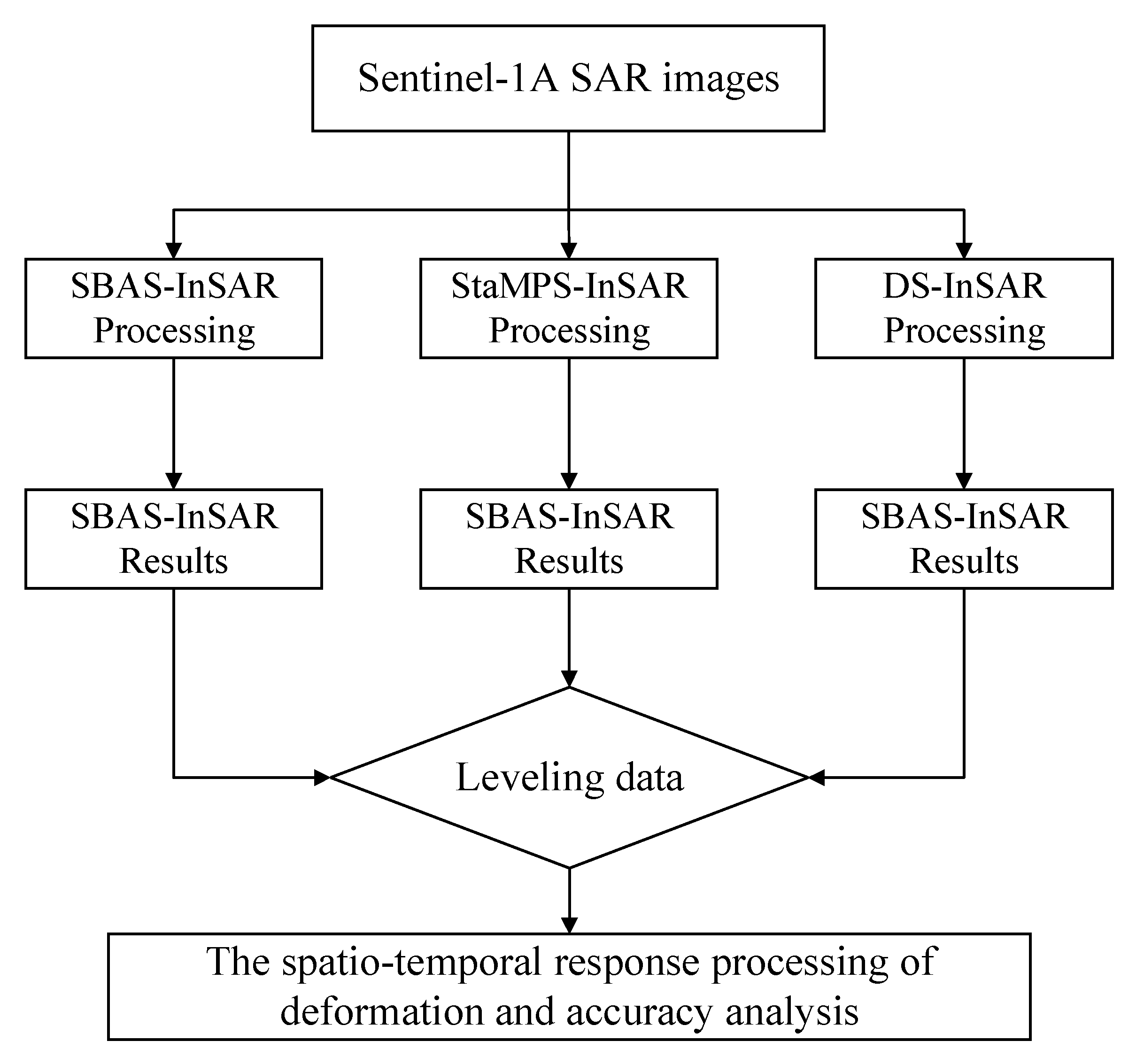
2. Methods and Principles
2.1. Principles of SBAS InSAR Technology
2.2. Principle of StaMPS-InSAR Technology
2.3. Principles of DS-InSAR Technology
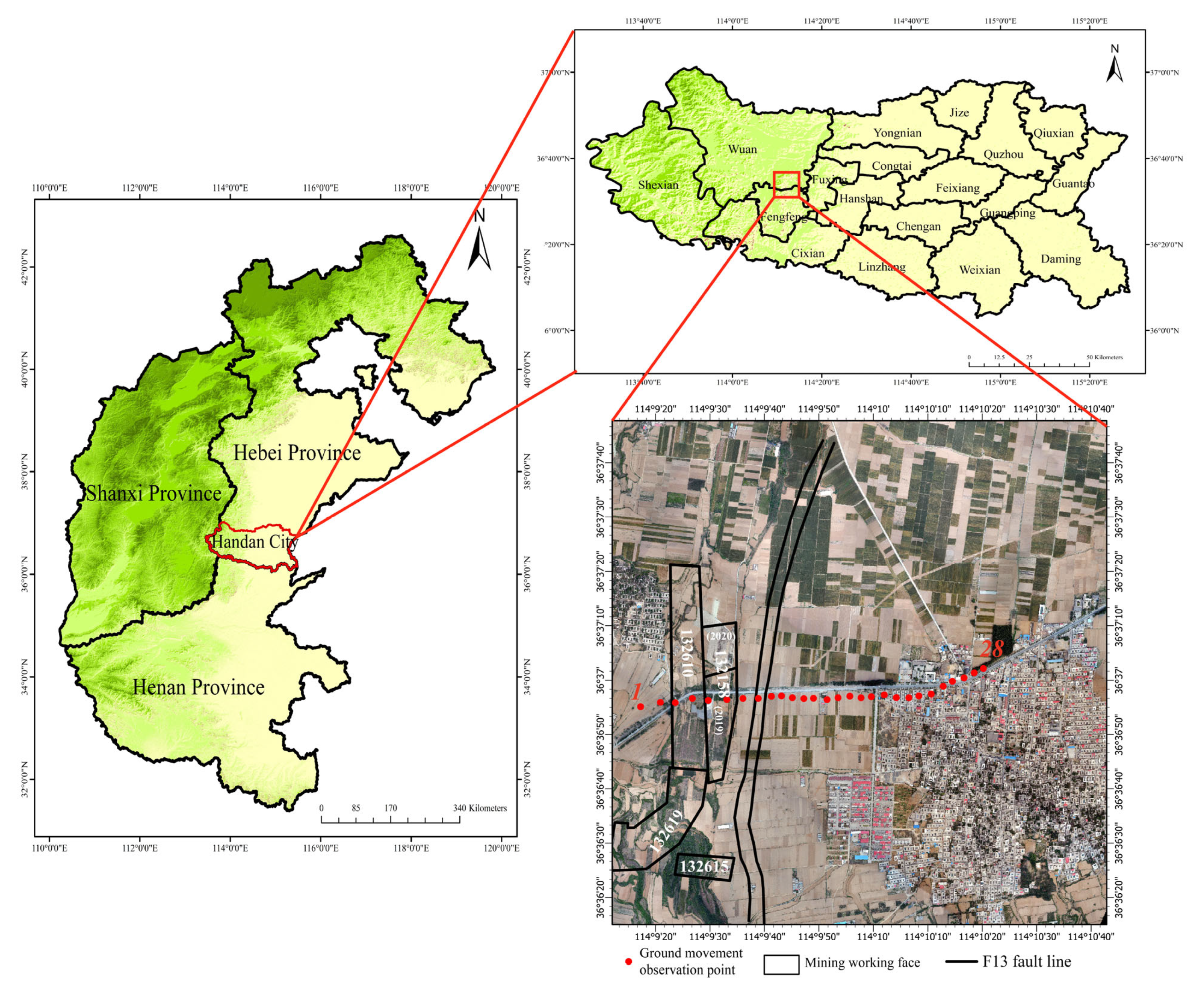
3. Overview and Data of the Research Area
3.1. Overview of the Research Area
3.2. Data Introduction
4. Monitoring Results and Analysis
4.1. Analysis of SBAS-InSAR Monitoring Results
4.2. StaMPS-InSAR Results
4.3. DS-InSAR Results
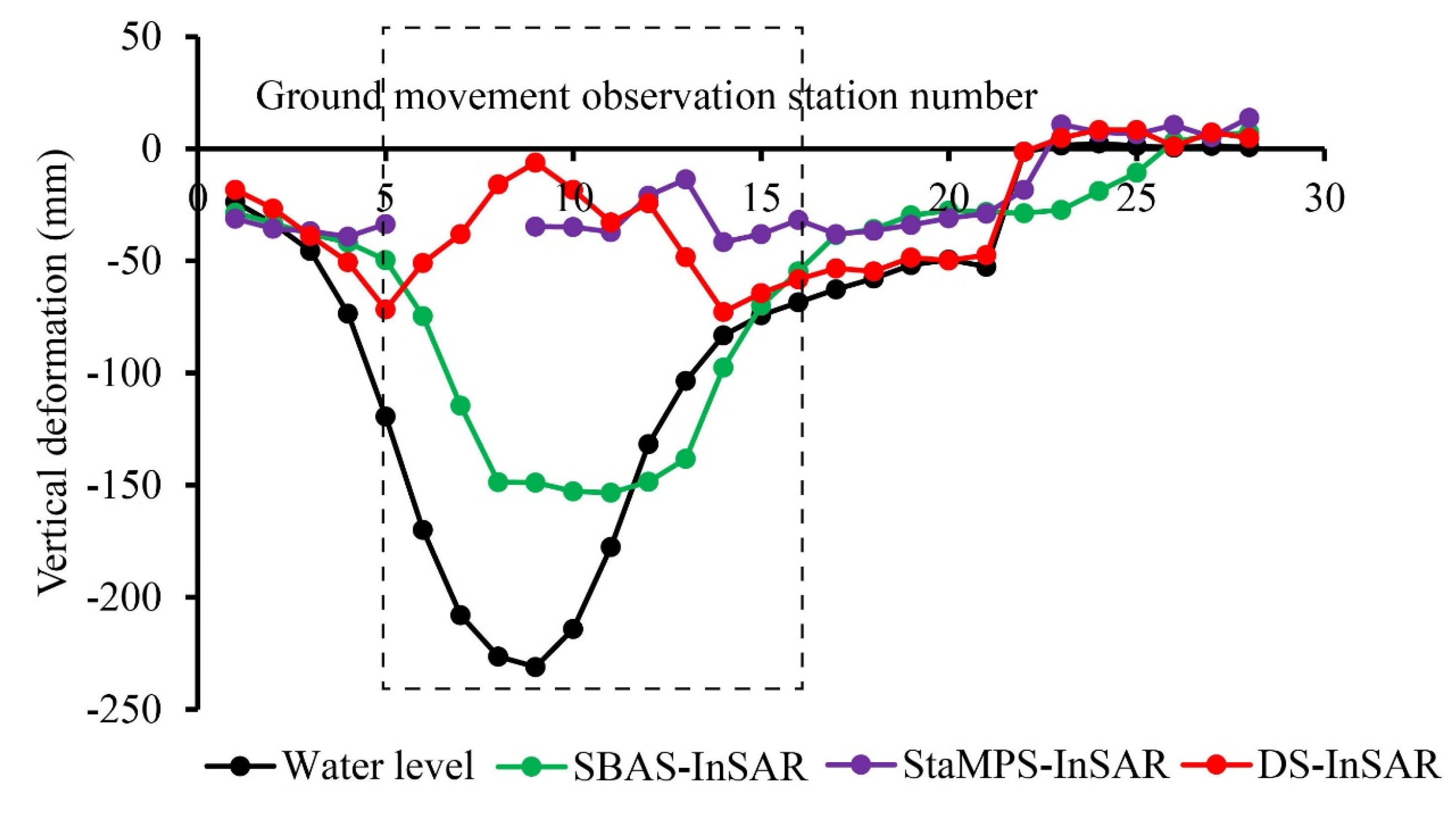
4.4. Verification of Monitoring Accuracy
5. Discussion
5.1. Mechanism of the Influence of Faults on Surface Deformation
5.2. Analysis of Fault-Induced Disturbances on Surface Deformation
5.3. Comparison of Three Time-Series InSAR Methods
6. Conclusions
Author Contributions
Funding
Data Availability Statement
Acknowledgments
Conflicts of Interest
References
- Yunjia, W. Research progress and prospect on ecological disturbance monitoring in mining area. Acta Geod. Cartogr. Sin. 2017, 46, 1705. [Google Scholar]
- Escayo, J.; Marzan, I.; Martí, D.; Tornos, F.; Farci, A.; Schimmel, M.; Carbonell, R.; Fernández, J. Radar Interferometry as a Monitoring Tool for an Active Mining Area Using Sentinel-1 C-Band Data, Case Study of Riotinto Mine. Remote Sens. 2022, 14, 3061. [Google Scholar] [CrossRef]
- Huang, J.; Deng, K.; Fan, H.; Yan, S. An improved pixel-tracking method for monitoring mining subsidence. Remote Sens. Lett. 2016, 7, 731–740. [Google Scholar] [CrossRef]
- Yuan, L.; Wang, E.Y.; Ma, Y.K.; Liu, Y.B.; Li, X.L. Research progress of coal and rock dynamic disasters and scientific and technological problems in China. J. China Coal Soc. 2023, 48, 1825–1845. [Google Scholar]
- Xie, H.; Ren, S.; Xie, Y.; Jiao, X. Development opportunities of the coal industry towards the goal of carbon neutrality. J. China Coal Soc. 2021, 46, 2197–2211. [Google Scholar]
- Chen, F.; Yu, H.; Bian, Z.; Yin, D. How to handle the crisis of coal industry in China under the vision of carbon neutrality. J. China Coal Soc. 2021, 46, 1808–1820. [Google Scholar]
- Yu, Q. Mechanism of abnormal subsidence induced by fault slipping instability during mining on hanging-wall and foot-wall. J. Min. Saf. Eng. 2021, 38, 41–50. [Google Scholar]
- Yu, Q.; Zhang, H.; Deng, W.; Zhang, Y.; Zhang, G. Different fault activation models in mining subsidence. J. China Coal Soc. 2019, 44, 2777–2786. [Google Scholar]
- Luo, J.; Guo, Q.; Chen, H.; Wang, X.; Wang, L.; Zhang, Y. Experimental simulation study on abnormal response of surface subsidence caused by mining in footwall of reverse fault. Prog. Geophys. 2022, 37, 1280–1291. [Google Scholar]
- Zhu, J.; Yang, Z.; Li, Z. Recent progress in retrieving and predicting mining-induced 3Ddisplace-ments using InSAR. Acta Geod. Cartogr. Sin. 2019, 48, 135–144. [Google Scholar] [CrossRef]
- Xia, K.Z.; Chen, C.X.; Wang, T.L.; Yang, K.Y.; Zhang, C.Q. Investigation of Mining-Induced Fault Reactivation Associated with Sublevel Caving in Metal Mines. Rock Mech. Rock Eng. 2022, 55, 5953–5982. [Google Scholar] [CrossRef]
- Berardino, P.; Fornaro, G.; Lanari, R.; Sansosti, E. A new algorithm for surface deformation monitoring based on small baseline differential SAR interferograms. IEEE Trans. Geosci. Remote Sens. 2002, 40, 2375–2383. [Google Scholar] [CrossRef]
- Hooper, A.; Segall, P.; Zebker, H. Persistent scatterer interferometric synthetic aperture radar for crustal deformation analysis, with application to Volcán Alcedo, Galápagos. J. Geophys. Res. Solid Earth 2007, 112, 1–21. [Google Scholar] [CrossRef]
- Cao, N.; Lee, H.; Jung, H.C. Mathematical Framework for Phase-Triangulation Algorithms in Distributed-Scatterer Interferometry. IEEE Geosci. Remote Sens. Lett. 2015, 12, 1838–1842. [Google Scholar] [CrossRef]
- Confuorto, P.; Casagli, N.; Casu, F.; De Luca, C.; Del Soldato, M.; Festa, D.; Lanari, R.; Manzo, M.; Onorato, G.; Raspini, F. Sentinel-1 P-SBAS data for the update of the state of activity of national landslide inventory maps. Landslides 2023, 20, 1083–1097. [Google Scholar] [CrossRef]
- Zhang, L.; Dai, K.; Deng, J.; Ge, D.; Liang, R.; Li, W.; Xu, Q. Identifying potential landslides by stacking-InSAR in southwestern China and its performance comparison with SBAS-InSAR. Remote Sens. 2021, 13, 3662. [Google Scholar] [CrossRef]
- Rosi, A.; Tofani, V.; Tanteri, L.; Tacconi Stefanelli, C.; Agostini, A.; Catani, F.; Casagli, N. The new landslide inventory of Tuscany (Italy) updated with PS-InSAR: Geomorphological features and landslide distribution. Landslides 2018, 15, 5–19. [Google Scholar] [CrossRef]
- Frattini, P.; Crosta, G.B.; Rossini, M.; Allievi, J. Activity and kinematic behaviour of deep-seated landslides from PS-InSAR displacement rate measurements. Landslides 2018, 15, 1053–1070. [Google Scholar] [CrossRef]
- Gu, X.; Li, Y.; Zuo, X.; Bu, J.; Yang, F.; Yang, X.; Li, Y.; Zhang, J.; Huang, C.; Shi, C. Image compression–based DS-InSAR method for landslide identification and monitoring of alpine canyon region: A case study of Ahai Reservoir area in Jinsha River Basin. Landslides 2024, 21, 2501–2517. [Google Scholar] [CrossRef]
- Li, Q.; Wang, W.; Wang, J.; Zhang, J.; Geng, D. Exploring the relationship between InSAR coseismic deformation and earthquake-damaged buildings. Remote Sens. Environ. 2021, 262, 112508. [Google Scholar] [CrossRef]
- Liu, F.; Elliott, J.R.; Craig, T.J.; Hooper, A.; Wright, T.J. Improving the resolving power of InSAR for earthquakes using time series: A case study in Iran. Geophys. Res. Lett. 2021, 48, e2021GL093043. [Google Scholar] [CrossRef]
- Wu, P.C.; Wei, M.; D Hondt, S. Subsidence in coastal cities throughout the world observed by InSAR. Geophys. Res. Lett. 2022, 49, e2022GL098477. [Google Scholar] [CrossRef]
- Murgia, F.; Bignami, C.; Brunori, C.A.; Tolomei, C.; Pizzimenti, L. Ground deformations controlled by hidden faults: Multi-frequency and multitemporal insar techniques for urban hazard monitoring. Remote Sens. 2019, 11, 2246. [Google Scholar] [CrossRef]
- Fernández-Torres, E.A.; Cabral-Cano, E.; Novelo-Casanova, D.A.; Solano-Rojas, D.; Havazli, E.; Salazar-Tlaczani, L. Risk assessment of land subsidence and associated faulting in Mexico City using InSAR. Nat. Hazards 2022, 112, 37–55. [Google Scholar] [CrossRef]
- Liu, L.; Yu, J.; Chen, B.; Wang, Y. Urban subsidence monitoring by SBAS-InSAR technique with multi-platform SAR images: A case study of Beijing Plain, China. Eur. J. Remote Sens. 2020, 53, 141–153. [Google Scholar] [CrossRef]
- Yan, Y.; Doin, M.-P.; Lopez-Quiroz, P.; Tupin, F.; Fruneau, B.; Pinel, V.; Trouvé, E. Mexico City subsidence measured by InSAR time series: Joint analysis using PS and SBAS approaches. IEEE J. Sel. Top. Appl. Earth Obs. Remote Sens. 2012, 5, 1312–1326. [Google Scholar] [CrossRef]
- Stramondo, S.; Bozzano, F.; Marra, F.; Wegmuller, U.; Cinti, F.R.; Moro, M.; Saroli, M. Subsidence induced by urbanisation in the city of Rome detected by advanced InSAR technique and geotechnical investigations. Remote Sens. Environ. 2008, 112, 3160–3172. [Google Scholar] [CrossRef]
- Perissin, D.; Wang, T. Time-series InSAR applications over urban areas in China. IEEE J. Sel. Top. Appl. Earth Obs. Remote Sens. 2010, 4, 92–100. [Google Scholar] [CrossRef]
- Martin, G.; Hooper, A.; Wright, T.J.; Selvakumaran, S. Blind source separation for MT-InSAR analysis with structural health monitoring applications. IEEE J. Sel. Top. Appl. Earth Obs. Remote Sens. 2022, 15, 7605–7618. [Google Scholar] [CrossRef]
- Ma, P.; Lin, H.; Wang, W.; Yu, H.; Chen, F.; Jiang, L.; Zhou, L.; Zhang, Z.; Shi, G.; Wang, J. Toward Fine Surveillance: A review of multitemporal interferometric synthetic aperture radar for infrastructure health monitoring. IEEE Geosci. Remote Sens. Mag. 2021, 10, 207–230. [Google Scholar] [CrossRef]
- Modeste, G.; Doubre, C.; Masson, F. Time evolution of mining-related residual subsidence monitored over a 24-year period using InSAR in southern Alsace, France. Int. J. Appl. Earth Obs. Geoinf. 2021, 102, 102392. [Google Scholar] [CrossRef]
- Pawluszek-Filipiak, K.; Borkowski, A. Monitoring mining-induced subsidence by integrating differential radar interferometry and persistent scatterer techniques. Eur. J. Remote Sens. 2021, 54, 18–30. [Google Scholar] [CrossRef]
- Tao, Q.; Wang, F.; Guo, Z.; Hu, L.; Yang, C.; Liu, T. Accuracy verification and evaluation of small baseline subset (SBAS) interferometric synthetic aperture radar (InSAR) for monitoring mining subsidence. Eur. J. Remote Sens. 2021, 54, 642–663. [Google Scholar] [CrossRef]
- Przyłucka, M.; Kowalski, Z.; Perski, Z. Twenty years of coal mining-induced subsidence in the Upper Silesia in Poland identified using InSAR. Int. J. Coal Sci. Technol. 2022, 9, 86. [Google Scholar] [CrossRef]
- Zhang, Y.; Kang, Y.; Wei, J.; Lu, Z.; Yan, W.; Wang, H.; Liu, Z.; Lv, X.; Zhou, M.; Li, K. SAR interferometry on full scatterers: Mapping ground deformation with ultra-high density from space. Remote Sens. Environ. 2024, 302, 113965. [Google Scholar]
- Chen, B.; Yang, Y.; Zhang, L.; Li, Z.; Zhu, C.; Yu, C.; Song, C.; Liu, N.; Liu, Z. A novel knowledge-learning coupling method for InSAR phase unwrapping of large surface displacements in coal mining areas. IEEE Trans. Geosci. Remote Sens. 2024, 99, 1–15. [Google Scholar] [CrossRef]
- Chen, B.; Yang, J.; Li, Z.; Yu, C.; Yu, Y.; Qin, L.; Yang, Y.; Yu, H. A new sequential homogeneous pixel selection algorithm for distributed scatterer InSAR. GIScience Remote Sens. 2023, 60, 2218261. [Google Scholar] [CrossRef]
- Yang, Y.; Chen, B.; Li, Z.; Yu, C.; Song, C.; Guo, F. A novel phase unwrapping method for low coherence interferograms in coal mining areas based on a fully convolutional neural network. IEEE J. Sel. Top. Appl. Earth Obs. Remote Sens. 2023, 17, 601–613. [Google Scholar] [CrossRef]
- Chen, B.; Li, Z.; Yu, C.; Fairbairn, D.; Kang, J.; Hu, J.; Liang, L. Three-dimensional time-varying large surface displacements in coal exploiting areas revealed through integration of SAR pixel offset measurements and mining subsidence model. Remote Sens. Environ. 2020, 240, 111663. [Google Scholar] [CrossRef]
- Chen, B.; Liu, H.; Li, Z.; Zheng, M.; Yu, Y.; Yu, H.; Qin, L.; Yang, J.; Yang, Y. Research progress and prospect of secondary subsidence monitoring, prediction and stability evaluation in closed underground mines. J. China Coal Soc. 2023, 48, 943–958. [Google Scholar]
- Yang, C.S.; Zhang, Q.; Zhao, C.Y.; Wang, Q.L.; Ji, L.Y. Monitoring land subsidence and fault deformation using the small baseline subset InSAR technique: A case study in the Datong Basin, China. J. Geodyn. 2014, 75, 34–40. [Google Scholar] [CrossRef]
- Diao, X.; Wu, K.; Chen, R.; Yang, J. Identifying the cause of abnormal building damage in mining subsidence areas using InSAR technology. IEEE Access 2019, 7, 172296–172304. [Google Scholar] [CrossRef]
- Qin, Z.; Agarwal, V.; Gee, D.; Marsh, S.; Grebby, S.; Chen, Y.; Meng, N. Study of ground movement in a mining area with geological faults using FDM analysis and a stacking InSAR method. Front. Environ. Sci. 2021, 9, 787053. [Google Scholar] [CrossRef]
- Hooper, A. A statistical-cost approach to unwrapping the phase of InSAR time series. In Proceedings of the International Workshop on ERS SAR Interferometry, Frascati, Italy, 4 December 2009. [Google Scholar]
- Jiang, M.; Ding, X.; Hanssen, R.F.; Malhotra, R.; Chang, L. Fast statistically homogeneous pixel selection for covariance matrix estimation for multitemporal InSAR. IEEE Trans. Geosci. Remote Sens. 2014, 53, 1213–1224. [Google Scholar] [CrossRef]
- Jiang, M.; Guarnieri, A.M. Distributed scatterer interferometry with the refinement of spatiotemporal coherence. IEEE Trans. Geosci. Remote Sens. 2020, 58, 3977–3987. [Google Scholar] [CrossRef]
- Donnelly, L.J. A review of international cases of fault reactivation during mining subsidence and fluid abstraction. Q. J. Eng. Geol. Hydrogeol. 2009, 42, 73–94. [Google Scholar] [CrossRef]
- Zhang, G.Y. Mechanism of Abnormal Surface Subsidence Induced by Fault Instability. Geotech. Geol. Eng. 2021, 39, 4781–4794. [Google Scholar] [CrossRef]
- Diao, X.P.; Sun, Q.S.; Zhang, Y.; Wu, K.; Yang, J.; Lu, X.; Wang, Q.W.; Wang, J. Spatiotemporal Evolution Law and the Mechanism of Abnormal Surface Deformation in Fault-Affected Mining Zones. IEEE Access 2023, 11, 119733–119747. [Google Scholar] [CrossRef]
- Yu, Q.; Zhang, H.; Deng, W.; Zou, Y. Analysis of fault separation generation and its increasing effect on mining zone. J. China Coal Soc. 2018, 43, 3286–3292. [Google Scholar]
- Li, S.; Xu, W.; Li, Z. Review of the SBAS InSAR Time-series algorithms, applications, and challenges. Geod. Geodyn. 2022, 13, 114–126. [Google Scholar] [CrossRef]
- Li, S.; Bian, Z.; Gao, Y.; Zhang, S.; Zheng, N.; Zhang, Q.; Zhang, Y.; Tian, Y. The adaptive phase optimization algorithm for DSInSAR driven by priori information. J. China Univ. Min. Technol. 2024, 53, 409–420. [Google Scholar]
- Du, Y.L.; Yan, S.Y.; Zhao, F.; Chen, D.; Zhang, H.L. DS-InSAR Based Long-Term Deformation Pattern Analysis in the Mining Region with an Improved Phase Optimization Algorithm. Front. Environ. Sci. 2022, 10, 799946. [Google Scholar] [CrossRef]


| Working Face | Mining Time Span | Mining Depth (m) | Mining Thickness (m) | Dip Angle of Coal Seam (°) |
|---|---|---|---|---|
| 132,610 | 2015.01–2017.02 | 700–880 | 5 | 25 |
| 132,158 | 2019.08–2020.07 | 750–900 | 4 | 24 |
| 132,619 | 2020.01–2020.10 | 600–750 | 4 | 17 |
| Parameter | Value |
|---|---|
| Wavelength | 5.6 cm |
| Imaging mode | IW |
| swath | IW2 |
| Central incidence angle (referring to the area) | 37.5° |
| Polarization mode | VH |
| Orbital direction | Ascending |
| Azimuth/Rang pixel spacing | 13.96 m × 2.33 m |
| 28 Ground Movement Observation Stations | 16 Ground Movement Observation Stations | |||||
|---|---|---|---|---|---|---|
| SBAS-InSAR | StaMPS-InSAR | DS-InSAR | SBAS-InSAR | StaMPS-InSAR | DS-InSAR | |
| RMSE | 41.3 | 71.2 | 87.7 | 19.3 | 16.4 | 7.7 |
| MAD | 95.4 | 196.3 | 224.9 | 31.7 | 34.4 | 23 |
Disclaimer/Publisher’s Note: The statements, opinions and data contained in all publications are solely those of the individual author(s) and contributor(s) and not of MDPI and/or the editor(s). MDPI and/or the editor(s) disclaim responsibility for any injury to people or property resulting from any ideas, methods, instructions or products referred to in the content. |
© 2024 by the authors. Licensee MDPI, Basel, Switzerland. This article is an open access article distributed under the terms and conditions of the Creative Commons Attribution (CC BY) license (https://creativecommons.org/licenses/by/4.0/).
Share and Cite
He, K.; Zou, Y.; Han, Z.; Huang, J. Time-Series InSAR Technology for Monitoring and Analyzing Surface Deformations in Mining Areas Affected by Fault Disturbances. Remote Sens. 2024, 16, 4811. https://doi.org/10.3390/rs16244811
He K, Zou Y, Han Z, Huang J. Time-Series InSAR Technology for Monitoring and Analyzing Surface Deformations in Mining Areas Affected by Fault Disturbances. Remote Sensing. 2024; 16(24):4811. https://doi.org/10.3390/rs16244811
Chicago/Turabian StyleHe, Kuan, Youfeng Zou, Zhigang Han, and Jilei Huang. 2024. "Time-Series InSAR Technology for Monitoring and Analyzing Surface Deformations in Mining Areas Affected by Fault Disturbances" Remote Sensing 16, no. 24: 4811. https://doi.org/10.3390/rs16244811
APA StyleHe, K., Zou, Y., Han, Z., & Huang, J. (2024). Time-Series InSAR Technology for Monitoring and Analyzing Surface Deformations in Mining Areas Affected by Fault Disturbances. Remote Sensing, 16(24), 4811. https://doi.org/10.3390/rs16244811