
Root-Zone Salinity in Irrigated Arid Farmland: Revealing Driving Mechanisms of Dynamic Changes in China’s Manas River Basin over 20 Years


Abstract

1. Introduction
2. Materials and Methods
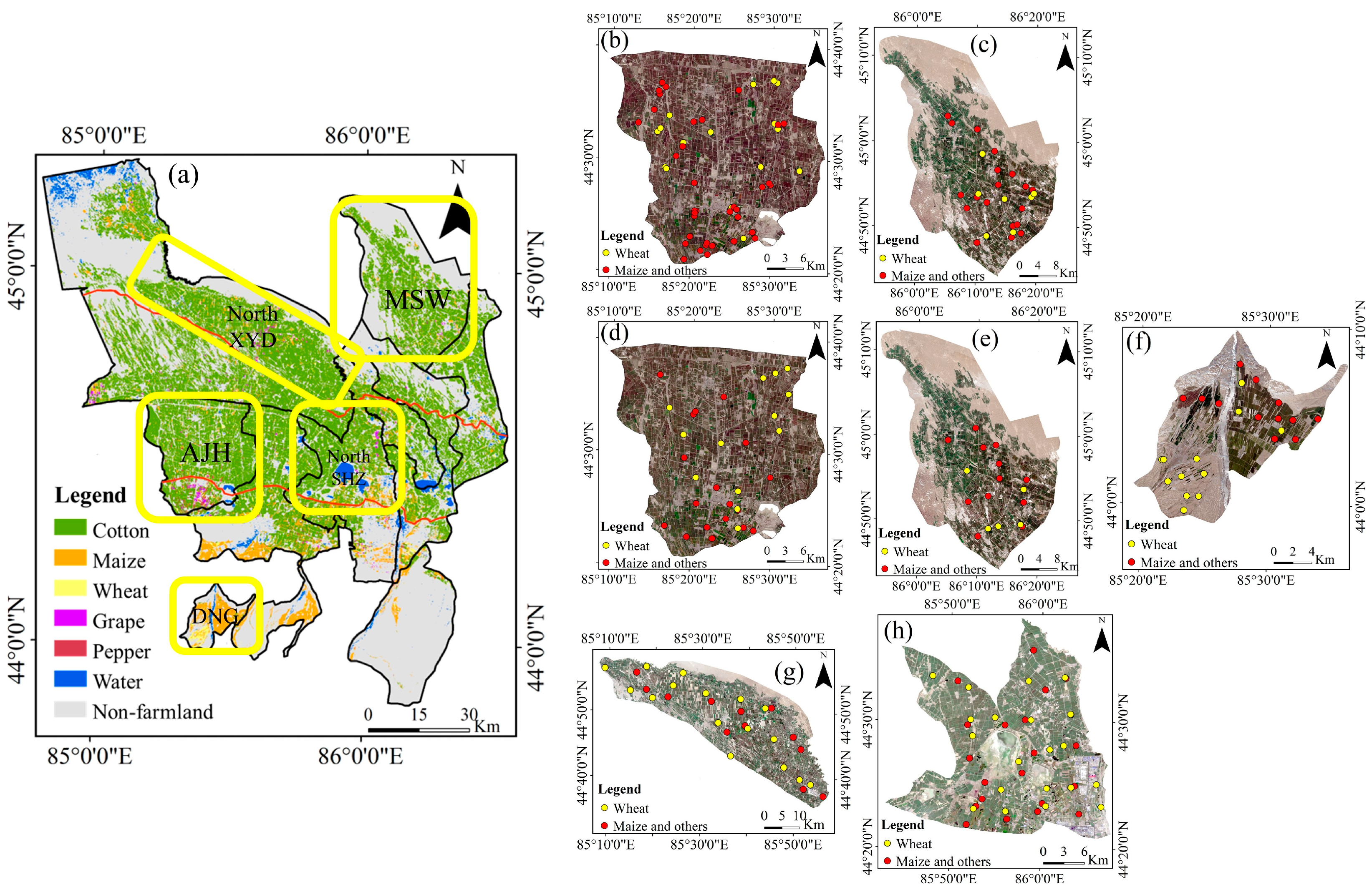
2.1. Overview of Study Area
2.2. Inversion and Data Collection of Root-Zone SSC
2.2.1. Remote Sensing Inversion Method of Root-Zone SSC
2.2.2. Regional Sampling and Investigation
2.2.3. Remote Sensing Data Processing
2.2.4. Required Data and Sources for SSC Inversion
- (1)
- Remote sensing images for ground feature classification: Sentinel images (10 m resolution) were available and used for crop identification from 2018 onward, while Landsat images (30 m resolution) were downloaded for those earlier years’ classification. Given Landsat’s 16-day revisit period, images with less than 10% cloud cover were selected during the April to October growth period from 2001 to 2022. Primarily, single images covering the study area were chosen to reduce errors from stitching; when unavailable, stitching methods were employed [32]. For Sentinel images, although no single image covers the entire area, their shorter revisit period (5 days for Sentinel-2A and 2B) allowed for more frequent data collection. Thus, a monthly NDVI maximum value composite method was used to create one cloud-free or less cloudy image each month [32]. In total, 93 images were collected for classification: 30 from Sentinel-2 and 23, 15, and 25 from Landsat-8, 7, and 5, respectively, using five bands (red, green, blue, near-infrared, and NDVI). Detailed information on the selected images, including datasets in GEE, dates, and bands, is provided in Supplementary Table S1.
- (2)
- Remote sensing images used for ET inversion: MODIS data (horizontal bands H23 and H24, vertical band V04) comprising daily surface reflectance (MOD09GA) and surface temperature (MOD11A1) from April to September of each year between 2001 and 2022 were sourced from the Level-1 Atmosphere Archive Distribution System (LAADS) Distributed Active Archive Center (DAAC) at the website https://ladsweb.modaps.eosdis.nasa.gov (accessed on 20 December 2022). Further details were described in Qiao et al. [11]. The Digital Elevation Model (DEM) data were obtained from the ASTER GDEM V2 dataset of the Geospatial Data Cloud (http://www.gscloud.cn, accessed on 18 November 2022), Computer Network Information Center, Chinese Academy of Sciences, with a spatial resolution of 30 m.
- (3)
- Meteorological data: Daily meteorological data needed for the SEBS model [11], including average temperature, maximum temperature, minimum temperature, air pressure, precipitation, wind speed, sunshine hours, and relative humidity from 42 meteorological stations in Xinjiang, spanning from 2001 to 2022, were sourced from the China Meteorological Data Sharing Service System (http://data.cma.cn, accessed on 26 December 2022)).
- (4)
- Irrigation data: Details such as irrigation method, timing, quantity, and leaching volume of each irrigation zone from 2001 to 2022 were retrieved from Shihezi Irrigation Annual Reports.
2.3. Driving Mechanism Analysis of Spatiotemporal Evolution of Root-Zone SSC
2.3.1. XGBoost Machine Learning Algorithm
2.3.2. SHAP and TreeSHAP Algorithms
2.3.3. Data and Sources Required for Driving Mechanism Analysis
2.4. Statistical Analysis
3. Results and Discussion
3.1. Estimation and Spatiotemporal Evolution of Root-Zone SSC
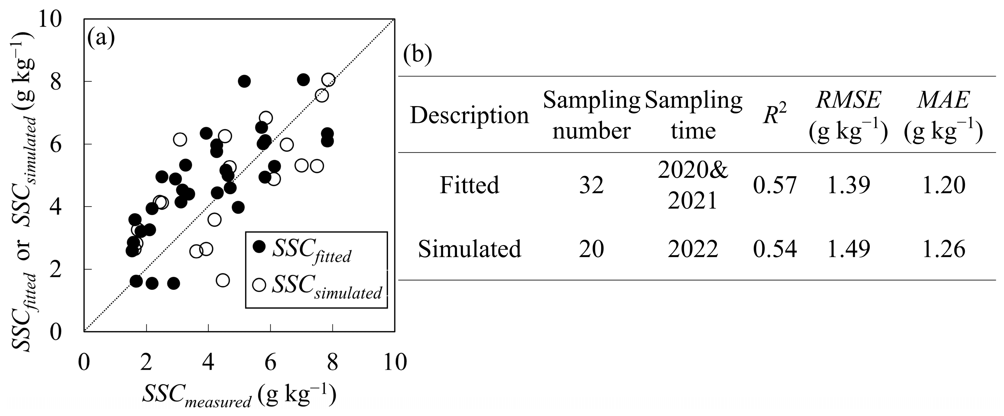
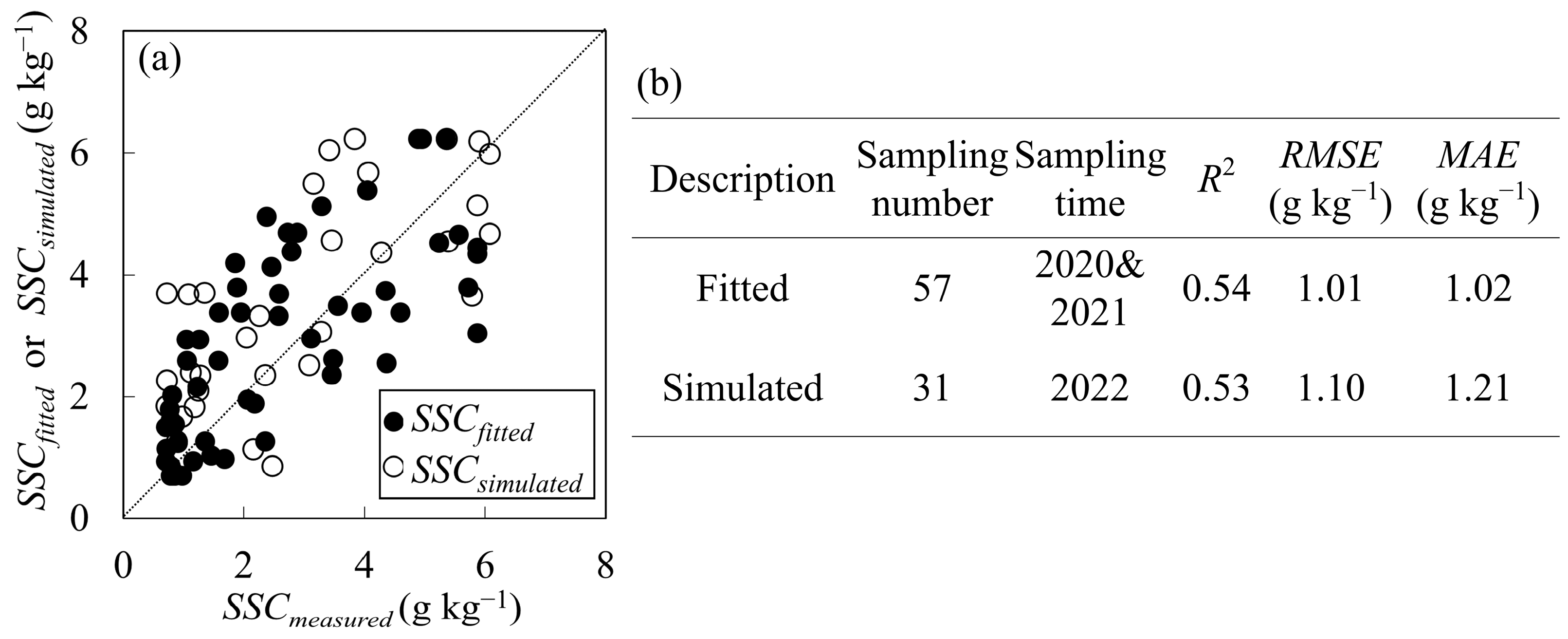
3.1.1. Verification of the Root-Zone SSC Inversion Method in Non-Cotton Fields
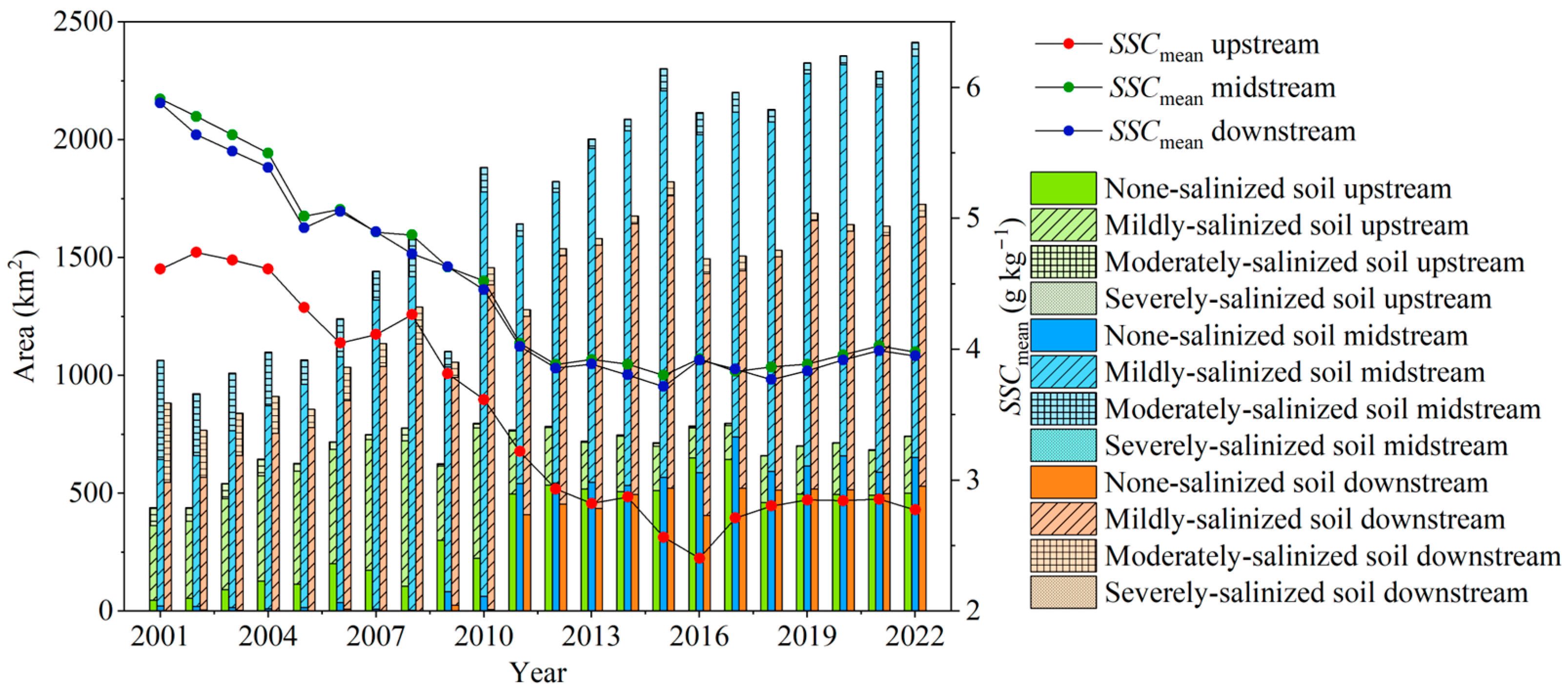
3.1.2. Dynamic Evolution of Root-Zone SSC Distributions
3.2. Driving Mechanisms for Root-Zone SSC Evolution
3.2.1. Parameter Optimization and Accuracy Evaluation of the XGBoost Model
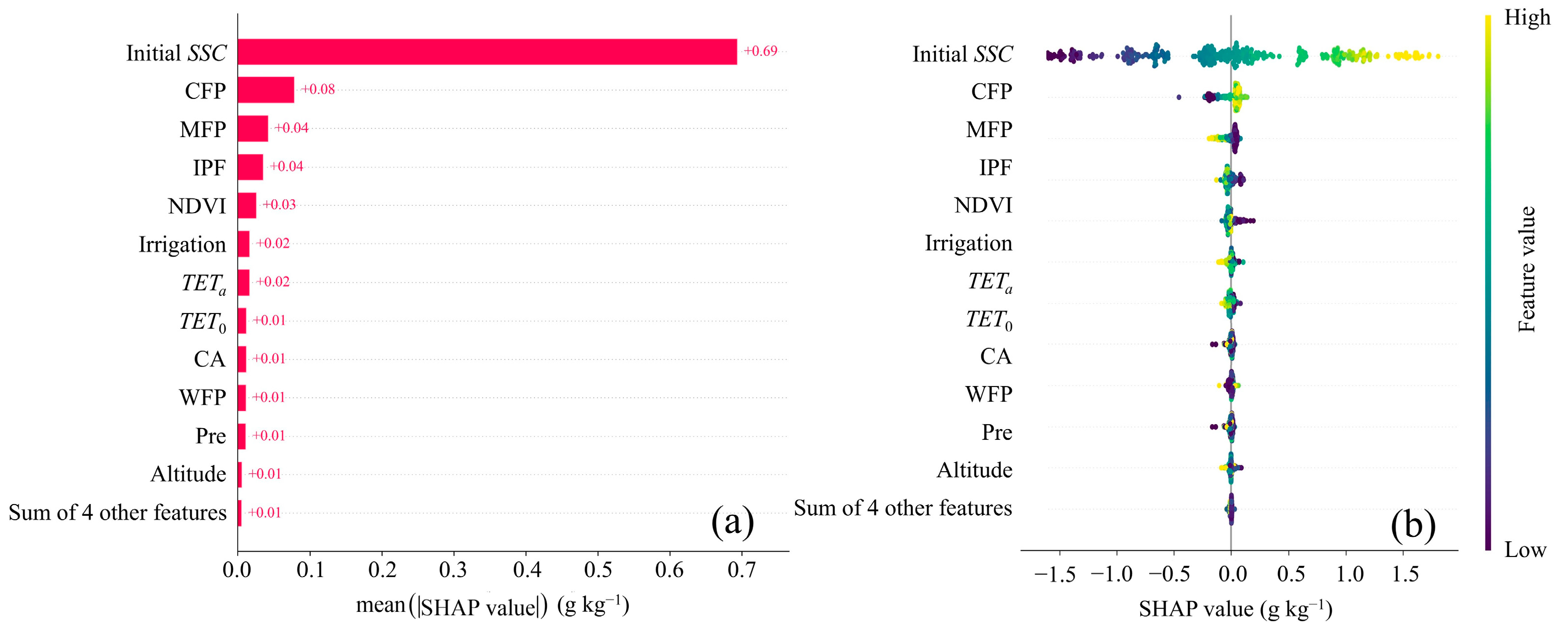
3.2.2. Overall Assessment of Influencing Factors Based on the TreeSHAP Algorithm
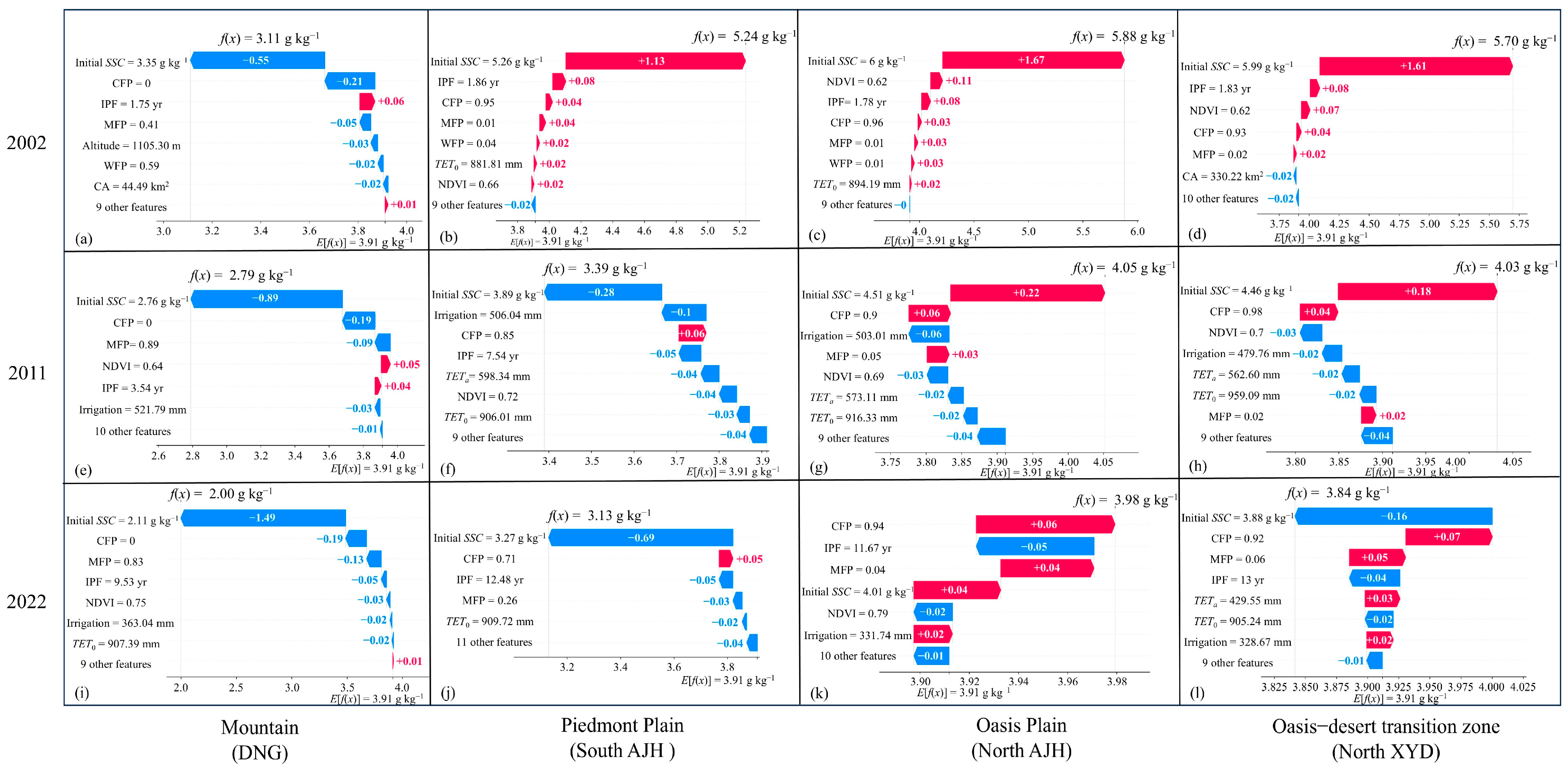
3.2.3. Further Interpretation on the Driving Mechanisms of SSC
3.2.4. Spatiotemporal Changes of Main Influencing Factors and Their Impacts
3.2.5. Possible Regulatory Measures Based on Driving Mechanism Analysis
4. Conclusions
- (1)
- The remote sensing inversion method accurately estimated root-zone SSC for various crops besides cotton, including wheat and maize, with an acceptable satisfactory R2 not less than 0.53. From 2001 to 2022, a basin-wide root-zone SSC was found to decrease 1.70 g kg−1, with a declining slow rate from 2011 or even a slight increase of 0.15 g kg−1 from 2017 to 2022 due to the adoption of FMDI technology, expanding farmland, and insufficient water supply.
- (2)
- The XGBoost model accurately predicted SSC dynamics, with R2 approaching 1 for the relationship between actual and predicted SSC values, and the SHAP-XGBoost model was effective in quantitatively interpreting the importance and contribution of different factors on predicted SSC. Among them, initial SSC, crop proportion (cotton and maize), implementation period of FMDI, NDVI, irrigation, and TETa were identified as the top seven factors influencing SSC variations. The analysis of SSC dynamics and their driving mechanisms revealed that reduced irrigation, caused by expanded cotton cultivation in the mid- and downstream regions, was the primary factor driving the recent increase in SSC. A simple scenario simulation showed that increasing irrigation per unit area and reducing cotton proportions in these regions could decrease SSC by up to 0.06 g kg−1. This emphasizes the importance of balancing cultivated area with water availability to reduce secondary salinization risks.
Supplementary Materials
Author Contributions
Funding
Data Availability Statement
Acknowledgments
Conflicts of Interest
References
- Daliakopoulos, I.N.; Tsanis, I.K.; Koutroulis, A.; Kourgialas, N.N.; Varouchakis, E.A.; Karatzas, G.P.; Ritsema, C.J. The threat of soil salinity: A European scale review. Sci. Total Environ. 2016, 573, 727–739. [Google Scholar] [CrossRef] [PubMed]
- Eswar, D.; Karuppusamy, R.; Chellamuthu, S. Drivers of soil salinity and their correlation with climate change. Curr. Opin. Environ. Sustain. 2021, 50, 310–318. [Google Scholar] [CrossRef]
- Ning, S.R.; Shi, J.C.; Zuo, Q.; Wang, S.; Ben-Gal, A. Generalization of the root length density distribution of cotton under film mulched drip irrigation. Field Crops Res. 2015, 177, 125–136. [Google Scholar] [CrossRef]
- Tan, S.; Wang, Q.; Xu, D.; Zhang, J.H.; Shan, Y.Y. Evaluating effects of four controlling methods in bare strips on soil temperature, water, and salt accumulation under film-mulched drip irrigation. Field Crops Res. 2017, 214, 350–358. [Google Scholar] [CrossRef]
- Wang, Z.; Fan, B.; Guo, L. Soil salinization after long-term mulched drip irrigation poses a potential risk to agricultural sustainability: Soil salinization under mulched drip irrigation. Eur. J. Soil Sci. 2019, 70, 20–24. [Google Scholar] [CrossRef]
- Salcedo, F.P.; Cutillas, P.P.; Cabaero, J.J.A.; Vivaldi, A.G. Use of remote sensing to evaluate the effects of environmental factors on soil salinity in a semi-arid area. Sci. Total Environ. 2021, 815, 152524. [Google Scholar] [CrossRef]
- Allbed, A.; Kumar, L. Soil salinity mapping and monitoring in arid and semi-arid regions using remote sensing technology: A review. Adv. Remote Sens. 2013, 2, 373–385. [Google Scholar] [CrossRef]
- Metternicht, G.I.; Zinck, J.A. Remote sensing of soil salinity: Potentials and constraints. Remote Sens. Environ. 2003, 85, 1–20. [Google Scholar] [CrossRef]
- Allbed, A.; Kumar, L.; Sinha, P. Mapping and modelling spatial variation in soil salinity in the Al Hassa oasis based on remote sensing indicators and regression techniques. Remote Sens. 2014, 6, 1137–1157. [Google Scholar] [CrossRef]
- Shi, H.Y.; Hellwich, O.; Luo, G.P.; Chen, C.B.; He, H.L.; Ochege, F.U.; Van de Voorde, T.; Kurban, A.; de Maeyer, P. A global Meta-Analysis of soil salinity prediction integrating satellite remote sensing, soil sampling, and machine learning. IEEE Trans. Geosci. Remote Sens. 2022, 60, 3109819. [Google Scholar] [CrossRef]
- Qiao, X.J.; Yang, G.; Shi, J.C.; Zuo, Q.; Liu, L.N.; Niu, M.; Wu, X.; Ben-Gal, A. Remote sensing data fusion to evaluate patterns of regional evapotranspiration: A case study for dynamics of film-mulched drip irrigated cotton in China’s Manas River Basin over 20 years. Remote Sens. 2022, 14, 3438. [Google Scholar] [CrossRef]
- Yang, G.; Qiao, X.J.; Zuo, Q.; Shi, J.C.; Wu, X.; Liu, L.N.; Ben-Gal, A. Remotely sensed estimation of root-zone salinity in salinized farmland based on soil-crop water relations. Sci. Remote Sens. 2023, 8, 100104. [Google Scholar] [CrossRef]
- Yang, F.; An, F.H.; Ma, H.Y.; Wang, Z.C.; Zhou, X.; Liu, Z.J. Variations on soil salinity and sodicity and its driving factors analysis under microtopography in different hydrological conditions. Water 2016, 8, 227. [Google Scholar] [CrossRef]
- Fei, Y.H.; She, D.L.; Fang, K. Identifying the main factors contributing to the spatial variability of soil saline–sodic properties in a reclaimed coastal area. Vadose Zone J. 2018, 17, 1180118. [Google Scholar] [CrossRef]
- Pya, N.; Wood, S.N. Shape constrained additive models. Stat. Comput. 2015, 25, 543–559. [Google Scholar] [CrossRef]
- Zou, H.; Hastie, T. Regularization and variable selection via the elastic net. J. R. Stat. Soc. Ser. B-Stat. Methodol. 2005, 67, 301–320. [Google Scholar] [CrossRef]
- Jordan, M.I.; Mitchell, T.M. Machine learning: Trends, perspectives, and prospects. Science 2015, 349, 255–260. [Google Scholar] [CrossRef]
- Erkin, N.; Zhu, L.; Gu, H.B.; Tusiyiti, A. Method for predicting soil salinity concentrations in croplands based on machine learning and remote sensing techniques. J. Appl. Remote Sens. 2019, 13, 034520. [Google Scholar] [CrossRef]
- Wang, N.; Xue, J.; Peng, J.; Biswas, A.; He, Y.; Shi, Z. Integrating remote sensing and landscape characteristics to estimate soil salinity using machine learning methods: A case study from southern Xinjiang, China. Remote Sens. 2020, 12, 4118. [Google Scholar] [CrossRef]
- Abedi, F.; Amirian-Chakan, A.; Faraji, M.; Taghizadeh-Mehrjardi, R.; Kerry, R.; Razmjoue, D.; Scholten, T. Salt dome related soil salinity in southern Iran: Prediction and mapping with averaging machine learning models. Land Degrad. Dev. 2021, 32, 1540–1554. [Google Scholar] [CrossRef]
- Belle, V.; Papantonis, I. Principles and practice of explainable machine learning. Front. Big Data. 2021, 41, 25. [Google Scholar] [CrossRef]
- Lundberg, S.M.; Lee, S.I. A unified approach to interpreting model predictions. In Proceedings of the 31st International Conference on Neural Information Processing Systems, Long Beach, CA, USA, 4–9 December 2017; pp. 4768–4777. [Google Scholar]
- Lundberg, S.M.; Erion, G.; Chen, H.; Degrave, A.; Prutkin, J.M.; Nair, B.; Katz, R.; Himmelfarb, J.; Bansal, N.; Lee, S. From local explanations to global understanding with explainable AI for trees. Nat. Mach. Intell. 2020, 2, 56–67. [Google Scholar] [CrossRef]
- Chen, T.Q.; Guestrin, C. Xgboost: A scalable tree boosting system. In Proceedings of the 22nd ACM SIGKDD International Conference on Knowledge Discovery and Data Mining (KDD), San Francisco, CA, USA, 13–17 August 2016; pp. 785–794. [Google Scholar] [CrossRef]
- Chen, S.C.; Liang, Z.Z.; Webster, R.; Zhang, G.L.; Zhou, Y.; Teng, H.F.; Hu, B.F.; Arrouays, D.; Shi, Z. A high-resolution map of soil pH in China made by hybrid modelling of sparse soil data and environmental covariates and its implications for pollution. Sci. Total Environ. 2019, 655, 273–283. [Google Scholar] [CrossRef]
- Jia, Y.; Jin, S.G.; Savi, P.; Gao, Y.; Tang, J.; Chen, Y.X.; Li, W.M. GNSS-R soil moisture retrieval based on a XGboost machine learning aided method: Performance and validation. Remote Sens. 2019, 11, 1655. [Google Scholar] [CrossRef]
- Zarei, A.; Hasanlou, M.; Mahdianpari, M. A comparison of machine learning models for soil salinity estimation using Multi-Spectral earth observation data. ISPRS Ann. Photogramm. Remote Sens. Spatial Inf. Sci. 2021, V-3-2021, 257–263. [Google Scholar] [CrossRef]
- Wang, L.Y.; Hu, P.; Zheng, H.W.; Liu, Y.; Cao, X.W.; Hellwich, O.; Liu, T.; Luo, G.P.; Bao, A.M.; Chen, X. Integrative modeling of heterogeneous soil salinity using sparse ground samples and remote sensing images. Geoderma 2023, 430, 116321. [Google Scholar] [CrossRef]
- Wang, J.J.; Liang, X.; Ma, B.; Liu, Y.F.; Jin, M.G.; Knappett, P.S.K.; Liu, Y.L. Using isotopes and hydrogeochemistry to characterize groundwater flow systems within intensively pumped aquifers in an arid inland basin, Northwest China. J. Hydrol. 2021, 595, 126048. [Google Scholar] [CrossRef]
- Zhang, F.H.; Zhao, Q.; Pan, X.D.; Li, Y.Y. Spatial differentiation and exploration direction of soil characteristic in valley of Manas River in Xinjiang. J. Soil Water Conserv. 2005, 19, 55–58. [Google Scholar] [CrossRef]
- Li, Y.Y.; Liu, H.D.; Zhang, F.H.; Chen, F.; Lai, X.Q. Assessment on the effect of irrigation technology on soil salinization in Manas River Valley, Xinjiang. J. China Agric. Univ. 2007, 53, 22–26. [Google Scholar]
- Yang, G.; Qiao, X.J.; Shi, J.C.; Wu, X.; Zhou, X.R.; Zhang, J.; Zuo, Q. Crop planting structure and water demand satisfaction degree in Manas River Basin from 2000 to 2020. Trans. Chin. Soc. Agric. Eng. 2022, 38, 156–166. [Google Scholar] [CrossRef]
- Sun, S.; Yang, X.G.; Li, K.N.; Zhao, J.; Ye, Q.; Xie, W.J.; Dong, C.Y.; Liu, H. Analysis of spatial and temporal characteristics of water requirement of winter wheat in China. Trans. Chin. Soc. Agric. Eng. 2013, 29, 72–82. [Google Scholar] [CrossRef]
- Wu, Y.F.; Bake, B.; Luo, N.N.; Rasulov, H. Variations in water requirement of winter wheat at different growth stages and its climatic cause in Shihezi region. Bull. Soil Water Conserv. 2016, 36, 69–74. [Google Scholar] [CrossRef]
- Qu, C.; Zhou, H.P.; Zhao, J. Experimental study on inter-annual water requirement and water consumption of drip irrigation maize in north of Xinjiang. Sci. Agric. Sin. 2017, 50, 2769–2780. [Google Scholar]
- Gao, J.; Zhang, H.J.; Ba, Y.C.; Wang, Y.C.; Li, F.Q.; Wang, Z.Y.; Zhang, W.H.; Jiang, T.L. Effects of regulated deficit irrigation on pepper growth and yield under drip irrigation in oasis region. Agric. Res. Arid. Areas 2019, 37, 25–31. [Google Scholar] [CrossRef]
- Yang, F.; Tian, J.C.; Zhu, H.; Yan, X.F. The effect of irrigation amount and drip irrigation methods on growth, yield and quality of wine grape. J. Irrig. Drain. 2021, 40, 1–6. [Google Scholar] [CrossRef]
- Maas, E.V. Crop tolerance to saline sprinkling water. Plant Soil 1985, 89, 273–284. [Google Scholar] [CrossRef]
- Slavich, P.; Petterson, G. Anion exclusion effects on estimates of soil chloride and deep percolation. Soil Res. 1993, 31, 455–463. [Google Scholar] [CrossRef]
- Li, M.; Zhang, X.L.; Wu, J.C. Sampling point arrangement based on GIS in eastern Henan Province. Soils 2011, 43, 459–465. [Google Scholar] [CrossRef]
- Bergstra, J.; Bengio, Y. Random search for hyper-parameter optimization. J. Mach. Learn. Res. 2012, 13, 281–305. [Google Scholar] [CrossRef]
- Burman, P. A comparative study of ordinary cross-validation, v-fold cross-validation and the repeated learning-testing methods. Biometrika 1989, 76, 503–514. [Google Scholar] [CrossRef]
- Li, D.B.; Li, X.L.; He, X.L.; Yang, G.; Du, Y.J.; Li, X.Q. Groundwater dynamic characteristics with the ecological threshold in the northwest China oasis. Sustainability 2022, 14, 5390. [Google Scholar] [CrossRef]
- Allen, R.G. Crop Evapotranspiration: Guidelines for Computing Crop Water Requirements; FAO Irrigation and Drainage Paper (FAO): Rome, Italy, 1998; p. 56. [Google Scholar]
- Yang, Y.T.; Shang, S.H.; Jiang, L. Remote sensing temporal and spatial patterns of evapotranspiration and the responses to water management in a large irrigation district of North China. Agric. For. Meteorol. 2012, 164, 112–122. [Google Scholar] [CrossRef]
- Mattar, M.A.; Alamoud, A.I. Artificial neural networks for estimating the hydraulic performance of labyrinth-channel emitters. Comput. Electron. Agric. 2015, 114, 189–201. [Google Scholar] [CrossRef]
- De Santis, A.; Asner, G.P.; Vaughan, P.J.; Knapp, D.E. Mapping burn severity and burning efficiency in California using simulation models and Landsat imagery. Remote Sens. Environ. 2010, 114, 1535–1545. [Google Scholar] [CrossRef]
- Li, J.; He, H.; Zeng, Q.; Chen, L.; Sun, R. A Chinese soil conservation dataset preventing soil water erosion from 1992 to 2019. Sci. Data 2023, 10, 319. [Google Scholar] [CrossRef] [PubMed]
- Li, W.H.; Wang, Z.H.; Zhang, J.Z.; Zong, R. Soil salinity variations and cotton growth under long-term mulched drip irrigation in saline-alkali land of arid oasis. Irrig. Sci. 2022, 40, 103–113. [Google Scholar] [CrossRef]
- Guan, Z.L.; Jia, Z.F.; Zhao, Z.Q.; You, Q.Y. Dynamics and distribution of soil salinity under Long-Term mulched drip irrigation in an arid area of northwestern China. Water 2019, 11, 1225. [Google Scholar] [CrossRef]
- Li, C.C.; Li, H.J.; Li, J.Z.; Lei, Y.P.; Li, C.Q.; Manevski, K.; Shen, Y.J. Using NDVI percentiles to monitor real-time crop growth. Comput. Electron. Agric. 2019, 162, 357–363. [Google Scholar] [CrossRef]


| Category | Description | Data Source | Time | Abbreviation | |
|---|---|---|---|---|---|
| Initial SSC | Average root-zone SSC in the previous year | Estimated based on remote sensing images, meteorological data, and irrigation data | 2001–2021 | Initial SSC | |
| Geography | Soil properties | Soil texture of 0–30 cm | Harmonized World Soil Database dataset (http://www.fao.org, accessed on accessed on 18 November 2022) | — | Top-ST |
| Soil texture of 30–60 cm | — | Sub-ST | |||
| Soil bulk density of 0–30 cm | — | Top-SBD | |||
| Soil bulk density of 30–60 cm | — | Sub-SBD | |||
| Altitude | Geospatial Data Cloud (https://www.gscloud.cn, accessed on 18 November 2022) | — | Altitude | ||
| Plant | Annual maximum NDVI | Inversely determined based on remote sensing images | 2001–2022 | NDVI | |
| Crop area | Inversely determined based on remote sensing images | 2001–2022 | CA | ||
| Meteorology | Total ETa from 1 April to 31 October | Estimated based on remote sensing images and meteorological data | 2001–2022 | TETa | |
| Total ET0 from 1 April to 31 October | Calculated based on meteorological data using Penman–Monteith equation | 2001–2022 | TET0 | ||
| Total precipitation from 1 April to 31 October | China Meteorological Data Sharing Service System (http://data.cma.cn, accessed on 26 December 2022) | 2001–2022 | Pre | ||
| Human activity | Planting structure | Proportion of cotton fields | Inversely determined based on remote sensing images | 2001–2022 | CFP |
| Proportion of wheat fields | |||||
| WFP | |||||
| Proportion of maize (and minority crops) fields | |||||
| MFP | |||||
| Total irrigation amount from 1 April to 31 October | Irrigation Annual Report of Shihezi City | 2001–2022 | Irrigation | ||
| Implementation period of FMDI | Obtained year-by-year based on remote sensing inversion of farmland distribution maps | 2001–2022 | IPF | ||
| Year | Sampling Area | Crop | Sampling | Maximum | Minimum | Mean |
|---|---|---|---|---|---|---|
| Number | g kg−1 | g kg−1 | g kg−1 | |||
| 2020 | AJH, MSW | Wheat | 18 | 7.83 | 1.55 | 4.04 ± 1.92 |
| Maize (and others) | 35 | 5.87 | 0.73 | 2.57 ± 1.80 | ||
| 2021 | DNG, AJH, MSW | Wheat | 14 | 7.73 | 1.59 | 3.98 ± 1.78 |
| Maize (and others) | 22 | 5.35 | 0.72 | 2.46 ± 1.57 | ||
| 2022 | North XYD, North SHZ | Wheat | 20 | 7.86 | 1.62 | 4.74 ± 2.18 |
| Maize (and others) | 31 | 6.08 | 0.72 | 2.95 ± 1.87 |
Disclaimer/Publisher’s Note: The statements, opinions and data contained in all publications are solely those of the individual author(s) and contributor(s) and not of MDPI and/or the editor(s). MDPI and/or the editor(s) disclaim responsibility for any injury to people or property resulting from any ideas, methods, instructions or products referred to in the content. |
© 2024 by the authors. Licensee MDPI, Basel, Switzerland. This article is an open access article distributed under the terms and conditions of the Creative Commons Attribution (CC BY) license (https://creativecommons.org/licenses/by/4.0/).
Share and Cite
Yang, G.; Qiao, X.; Zuo, Q.; Shi, J.; Wu, X.; Ben-Gal, A. Root-Zone Salinity in Irrigated Arid Farmland: Revealing Driving Mechanisms of Dynamic Changes in China’s Manas River Basin over 20 Years. Remote Sens. 2024, 16, 4294. https://doi.org/10.3390/rs16224294
Yang G, Qiao X, Zuo Q, Shi J, Wu X, Ben-Gal A. Root-Zone Salinity in Irrigated Arid Farmland: Revealing Driving Mechanisms of Dynamic Changes in China’s Manas River Basin over 20 Years. Remote Sensing. 2024; 16(22):4294. https://doi.org/10.3390/rs16224294
Chicago/Turabian StyleYang, Guang, Xuejin Qiao, Qiang Zuo, Jianchu Shi, Xun Wu, and Alon Ben-Gal. 2024. "Root-Zone Salinity in Irrigated Arid Farmland: Revealing Driving Mechanisms of Dynamic Changes in China’s Manas River Basin over 20 Years" Remote Sensing 16, no. 22: 4294. https://doi.org/10.3390/rs16224294
APA StyleYang, G., Qiao, X., Zuo, Q., Shi, J., Wu, X., & Ben-Gal, A. (2024). Root-Zone Salinity in Irrigated Arid Farmland: Revealing Driving Mechanisms of Dynamic Changes in China’s Manas River Basin over 20 Years. Remote Sensing, 16(22), 4294. https://doi.org/10.3390/rs16224294