
Monitoring Aeolian Erosion from Surface Coal Mines in the Mongolian Gobi Using InSAR Time Series Analysis


Abstract

1. Introduction
2. Test Site and Data Sets
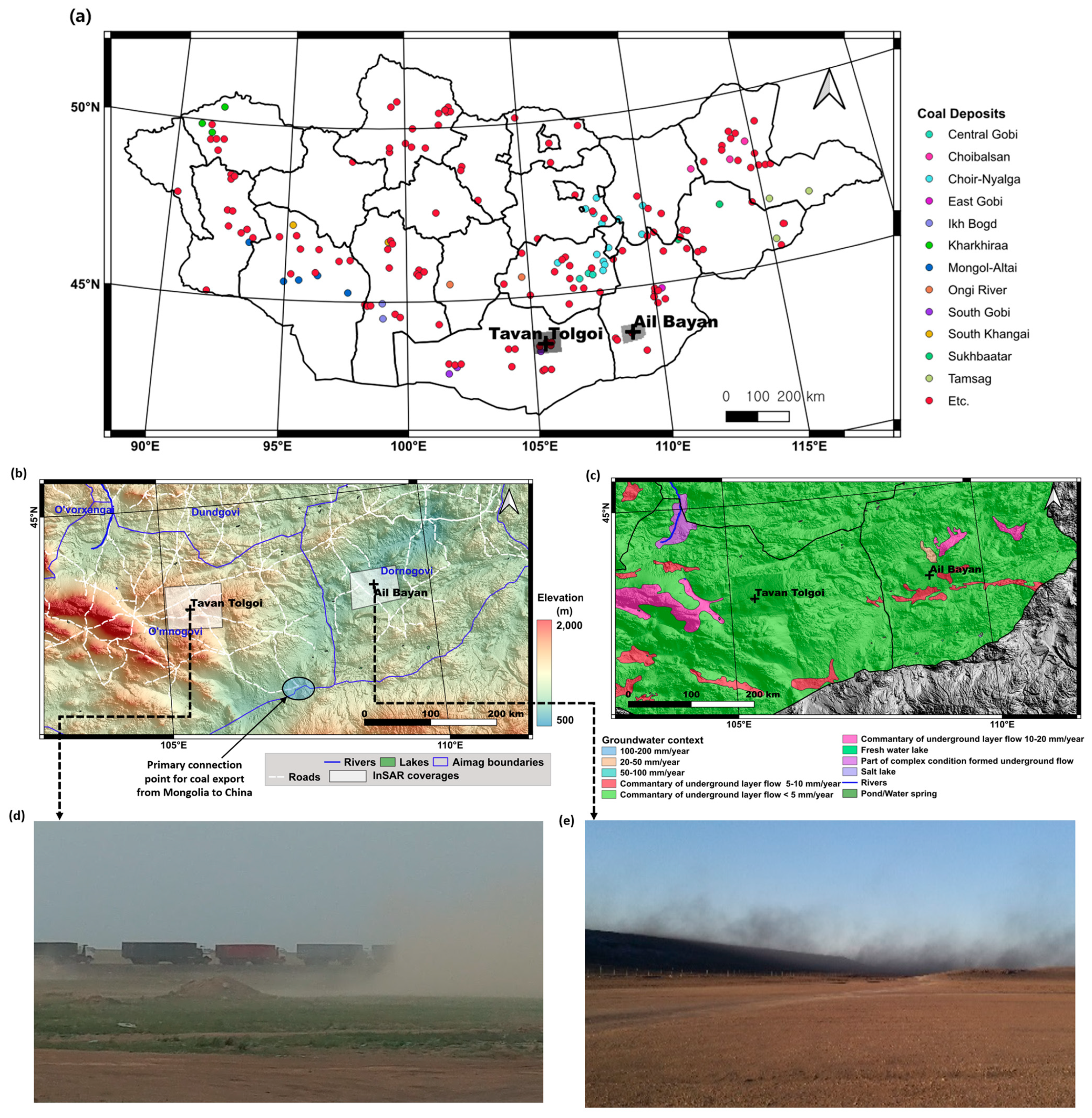
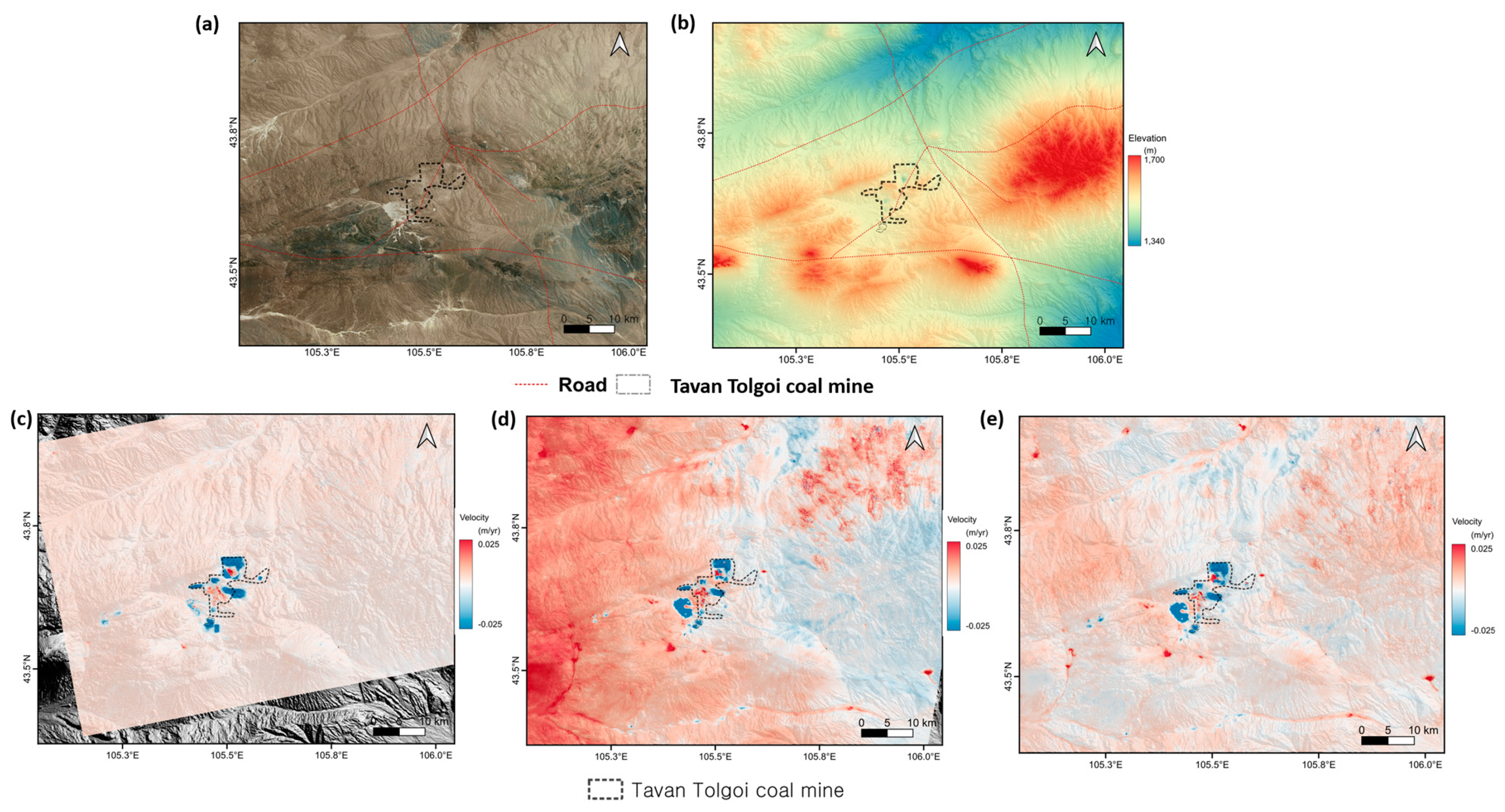
2.1. Test Area and Its Background
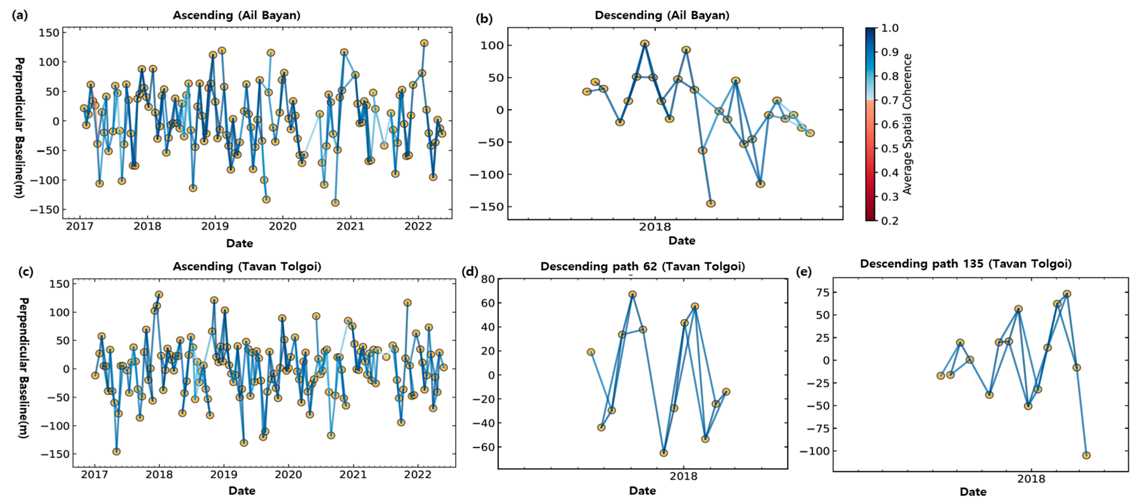
2.2. Data Sets
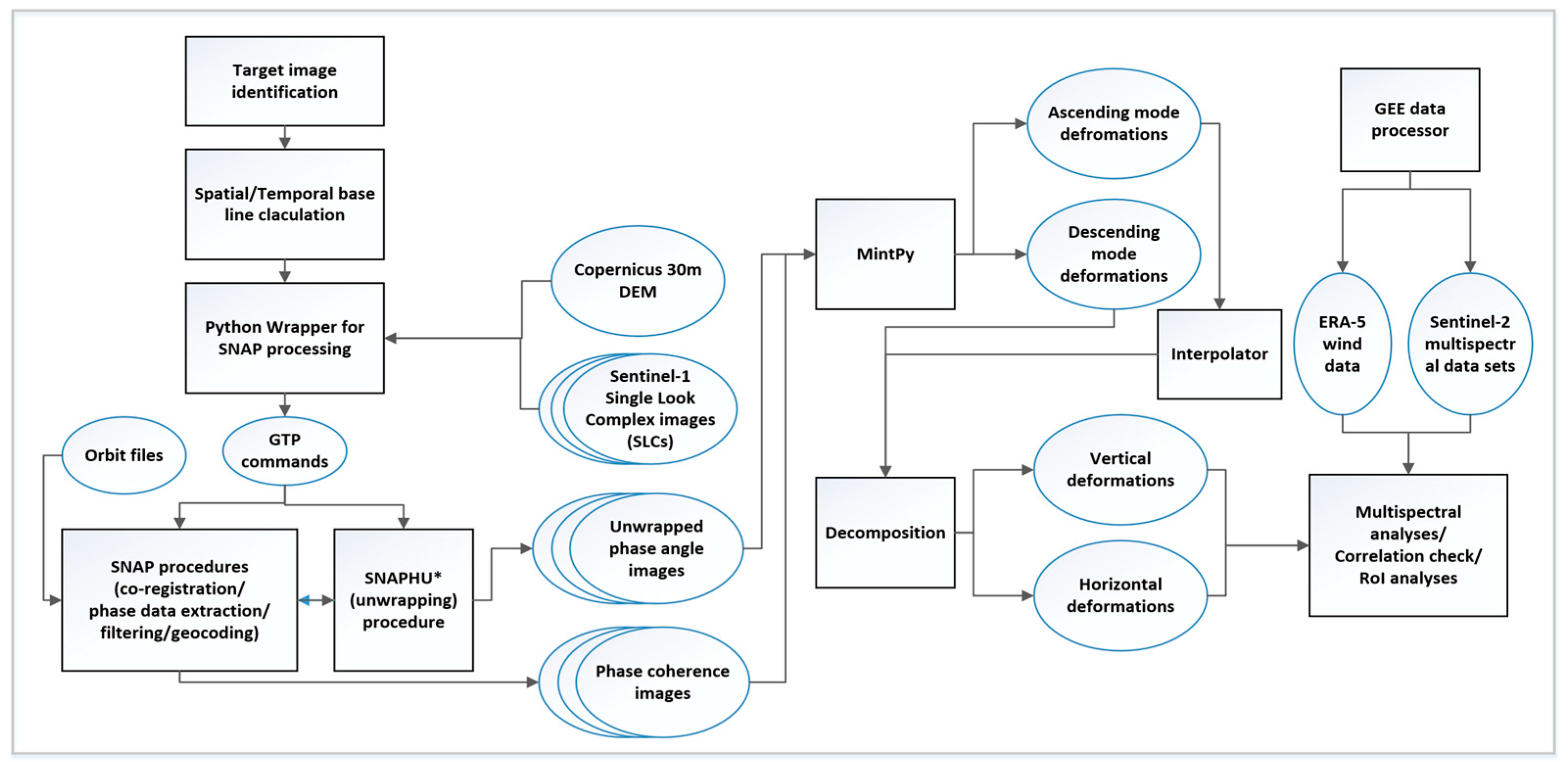
3. Methods
3.1. InSAR Time Series Analyses and Decomposition
- Atmospheric and topographic noise removal: MintPy uses external atmospheric data or a topography-dependent approach to eliminate atmospheric phase screen (APS) together with dereamping and topographic noise removal algorithms.
- Phase unwrapping error correction: MintPy incorporates methods to correct or exclude phase unwrapping errors, ensuring more reliable output.
- Improved phase inversion approach: MintPy provides an enhanced phase inversion approach, resulting in more accurate measurements.
3.2. Processing of Optical Images
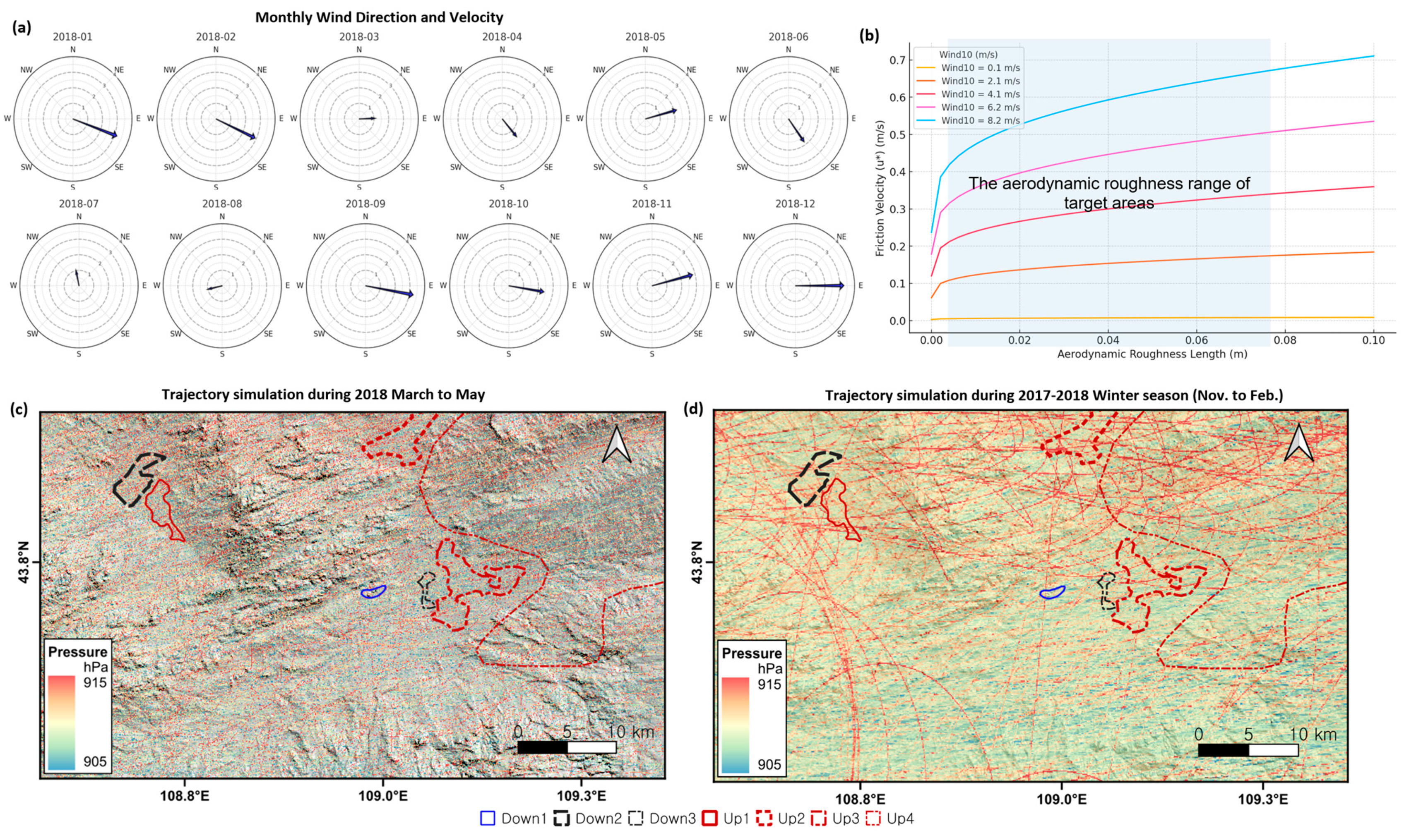
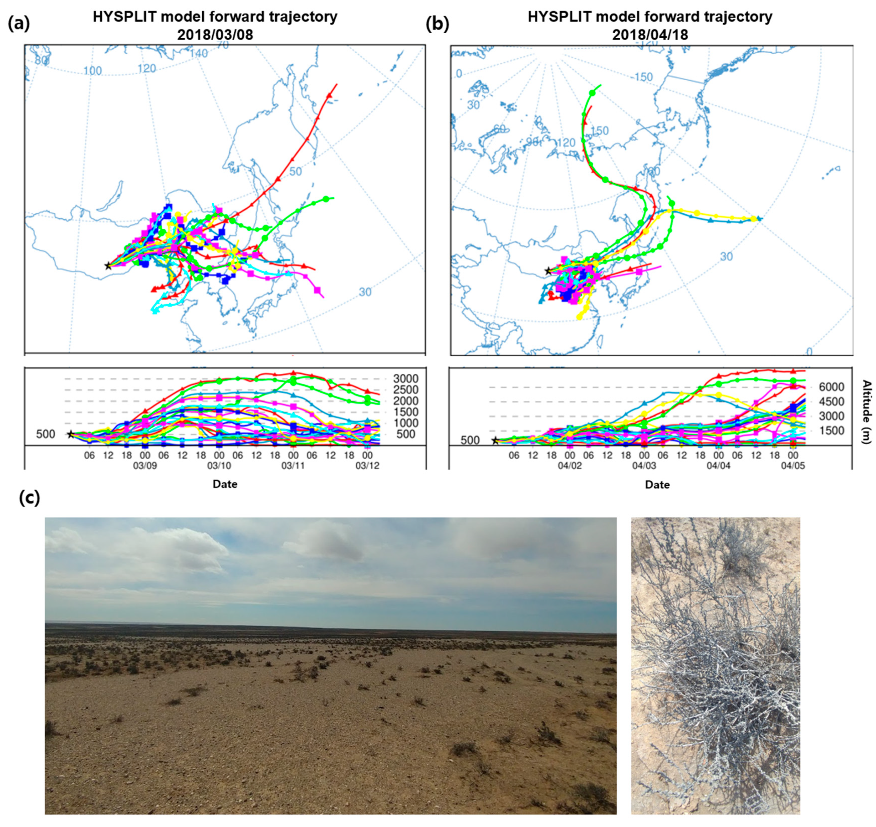
3.3. Trajectory Analyses
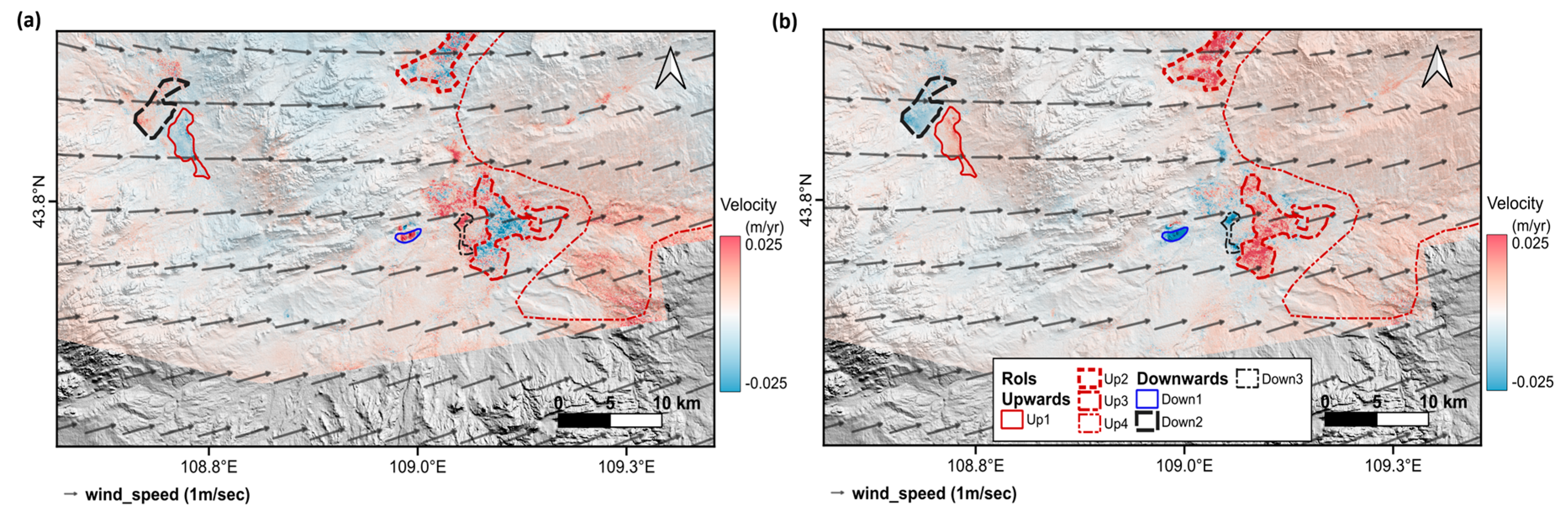
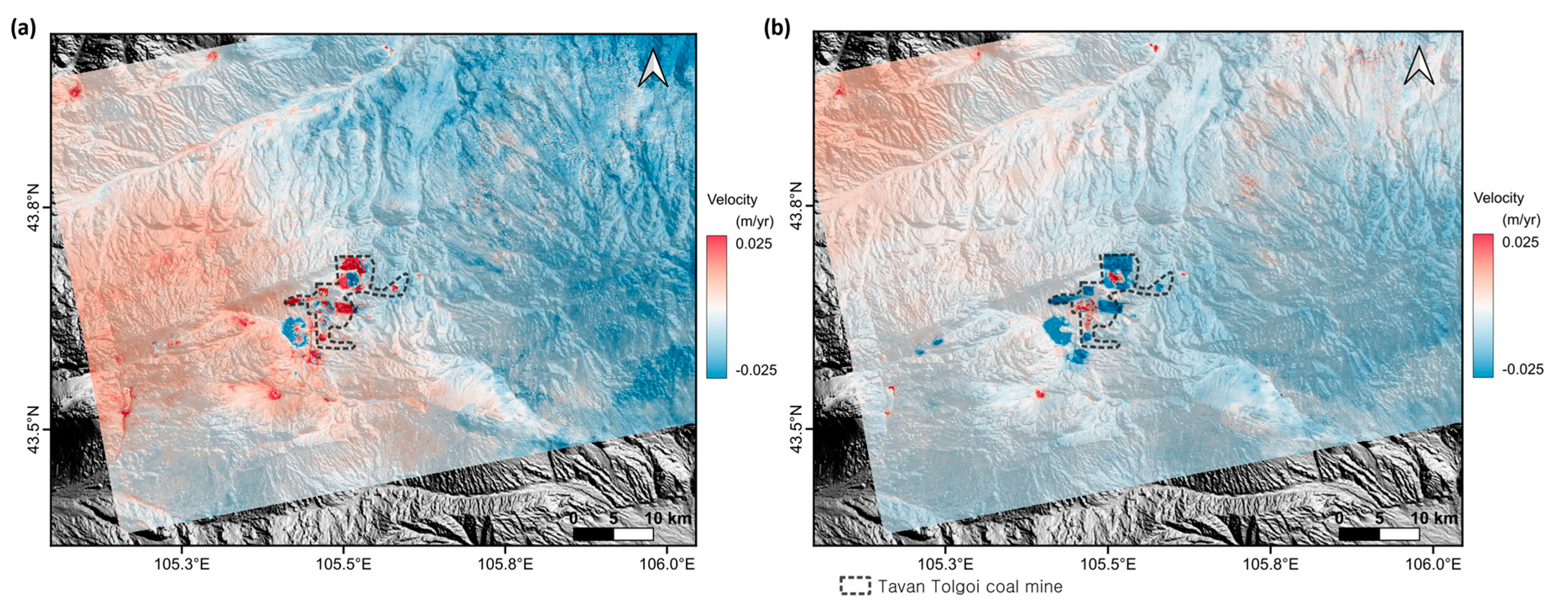
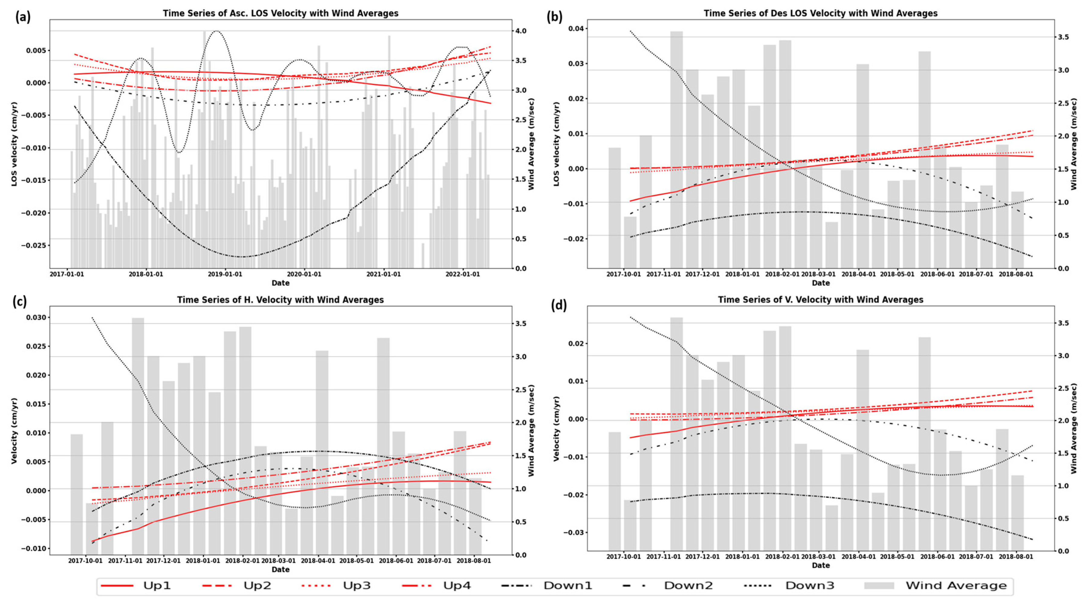
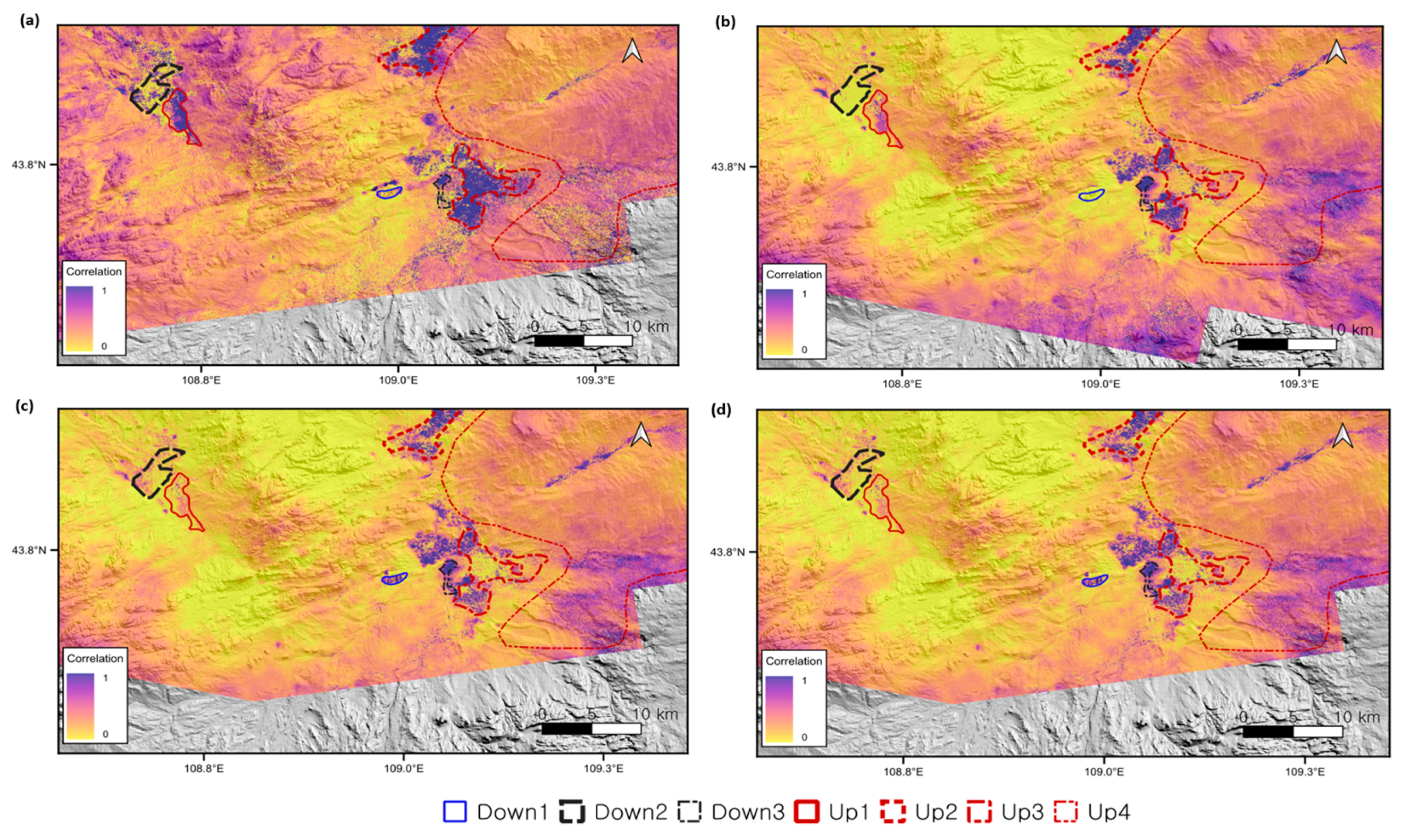
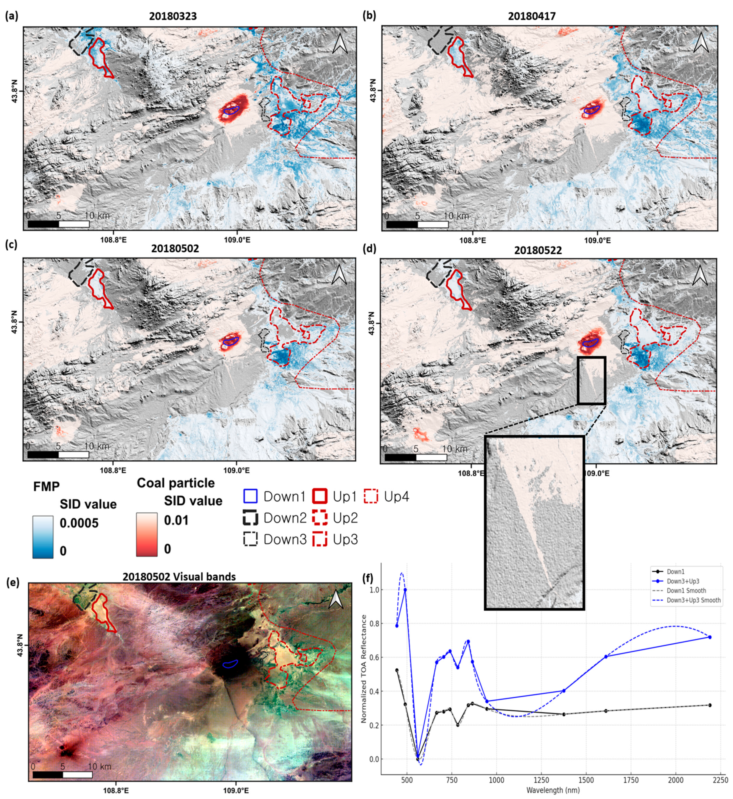
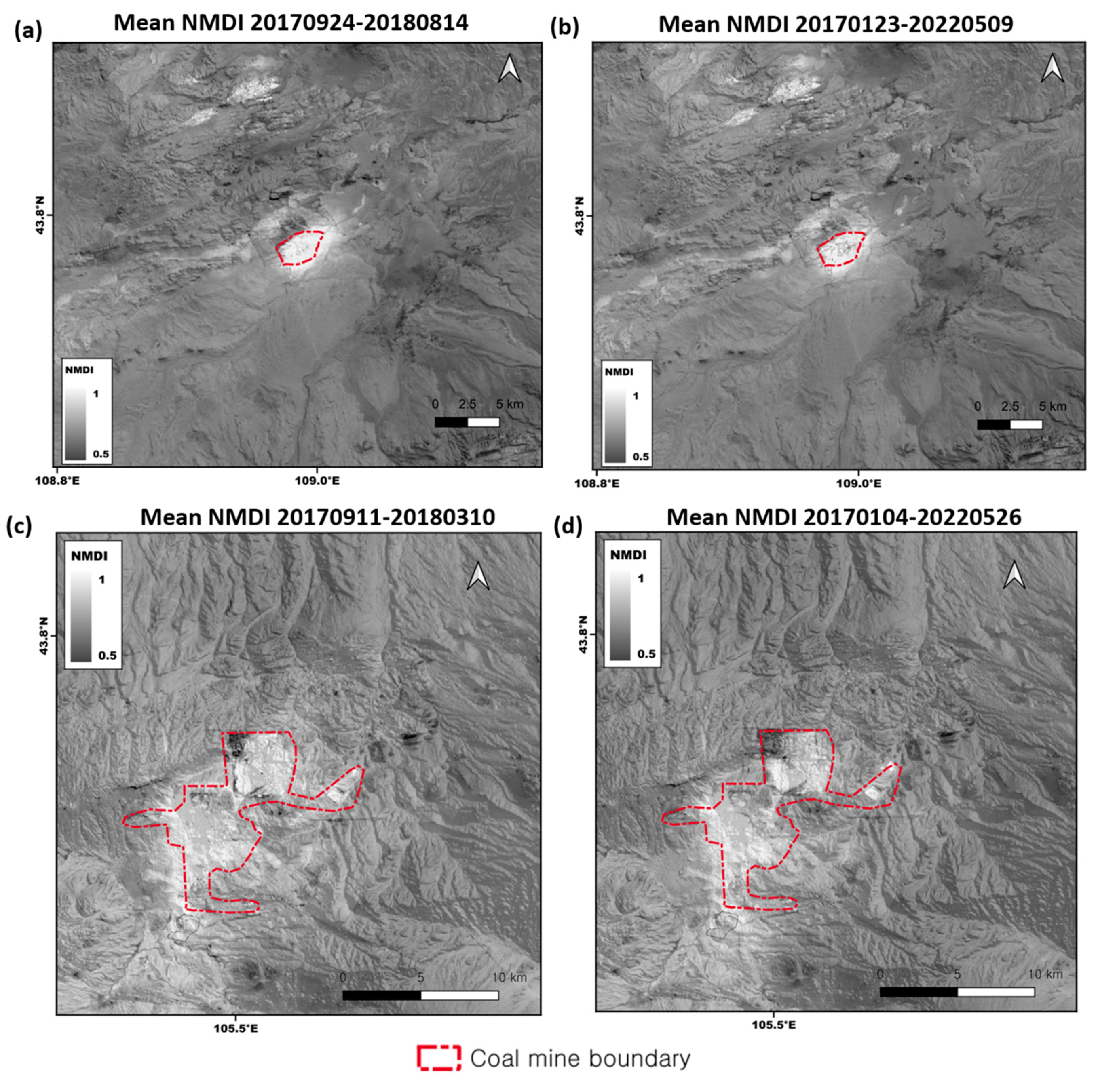
4. Result
5. Interpretation & Validation
6. Conclusions
Author Contributions
Funding
Data Availability Statement
Acknowledgments
Conflicts of Interest
References
- Lin, C.; Tong, X.; Lu, W.; Yan, L.; Wu, Y.; Nie, C.; Chu, C.; Long, J. Environmental impacts of surface mining on mined lands, affected streams and agricultural lands in the Dabaoshan Mine region, southern China. Land Degrad. Dev. 2005, 16, 463–474. [Google Scholar] [CrossRef]
- Wolkersdorfer, C.; Mugova, E. Effects of mining on surface water. Encycl. Inland Waters 2022, 4, 170–188. [Google Scholar]
- Tiwary, R. Environmental impact of coal mining on water regime and its management. Water Air Soil Pollut. 2001, 132, 185–199. [Google Scholar] [CrossRef]
- Wang, S.; Li, X.; Wang, D. Void fraction distribution in overburden disturbed by longwall mining of coal. Environ. Earth Sci. 2016, 75, 1–17. [Google Scholar] [CrossRef]
- De Rosa, M.I. Analysis of Mine Fires for All US Underground and Surface Coal Mining Categories: 1990–1999; NIOSH: Cincinnati, OH, USA, 2004. [Google Scholar]
- Kim, J.; Lin, S.-Y.; Singh, R.P.; Lan, C.-W.; Yun, H.-W. Underground burning of Jharia coal mine (India) and associated surface deformation using InSAR data. Int. J. Appl. Earth Obs. Geoinf. 2021, 103, 102524. [Google Scholar] [CrossRef]
- Sánchez-Donoso, R.; Martín-Duque, J.F.; Crespo, E.; Higueras, P.L. Tailing’s geomorphology of the San Quintín mining site (Spain): Landform catalogue, aeolian erosion and environmental implications. Environ. Earth Sci. 2019, 78, 166. [Google Scholar] [CrossRef]
- Ferreira, M.; Furieri, B.; Santos, J.; El Moctar, A.O.; Harion, J.-L.; Valance, A.; Dupont, P.; Reis, N. An experimental and numerical study of the aeolian erosion of isolated and successive piles. Environ. Fluid Mech. 2020, 20, 123–144. [Google Scholar] [CrossRef]
- Baruya, P. Losses in the Coal Supply Chain; IEA Clean Coal Centre: London, UK, 2012. [Google Scholar]
- Perret, J.L.; Plush, B.; Lachapelle, P.; Hinks, T.S.; Walter, C.; Clarke, P.; Irving, L.; Brady, P.; Dharmage, S.C.; Stewart, A. Coal mine dust lung disease in the modern era. Respirology 2017, 22, 662–670. [Google Scholar] [CrossRef]
- Pan, L.; Golden, S.; Assemi, S.; Sime, M.F.; Wang, X.; Gao, Y.; Miller, J. Characterization of particle size and composition of respirable coal mine dust. Minerals 2021, 11, 276. [Google Scholar] [CrossRef]
- Liu, T.; Liu, S. The impacts of coal dust on miners’ health: A review. Environ. Res. 2020, 190, 109849. [Google Scholar] [CrossRef]
- Abbasi, B.; Wang, X.; Chow, J.C.; Watson, J.G.; Peik, B.; Nasiri, V.; Riemenschnitter, K.B.; Elahifard, M. Review of respirable coal mine dust characterization for mass concentration, size distribution and chemical composition. Minerals 2021, 11, 426. [Google Scholar] [CrossRef]
- Amgalan, G.; Liu, G.-R.; Kuo, T.-H.; Tang-Huang, L. Correlation between dust events in Mongolia and surface wind and precipitation. TAO Terr. Atmos. Ocean. Sci. 2017, 28, 2. [Google Scholar] [CrossRef]
- Kim, J.; Dorjsuren, M.; Zucca, C.; Purevjav, G. Mapping land degradation and sand and dust generation hotspots by spatiotemporal data fusion analysis: A case-study in the southern Gobi (Mongolia). Land Degrad. Dev. 2023, 34, 1629–1647. [Google Scholar] [CrossRef]
- Kim, J.-R.; Lin, C.-W.; Lin, S.-Y. The Use of InSAR Phase Coherence Analyses for the Monitoring of Aeolian Erosion. Remote Sens. 2021, 13, 2240. [Google Scholar] [CrossRef]
- Kim, J.; Dorjsuren, M.; Choi, Y.; Purevjav, G. Reconstructed aeolian surface erosion in southern Mongolia by multi-temporal InSAR phase coherence analyses. Front. Earth Sci. 2020, 8, 531104. [Google Scholar] [CrossRef]
- Avirmed, D. Mineral resources of Mongolia as a driving force of the country. Mong. J. Int. Aff. 2021, 22, 61–66. [Google Scholar] [CrossRef]
- Gerel, O.; Pirajno, F.; Batkhishig, B.; Dostal, J. Mineral Resources of Mongolia; Springer: Berlin/Heidelberg, Germany, 2021. [Google Scholar]
- Erdenetsogt, B.-O.; Lee, I.; Bat-Erdene, D.; Jargal, L. Mongolian coal-bearing basins: Geological settings, coal characteristics, distribution, and resources. Int. J. Coal Geol. 2009, 80, 87–104. [Google Scholar] [CrossRef]
- Tsembelsuren, B.; Hwan, Y.C.; Rong, K. Study of Coal Trade between Mongolia and China, its Effect in Mongolian Coal Market. Eur. Res. 2012, 19, 379–382. [Google Scholar]
- Ma, Q.; Wu, J.; He, C.; Fang, X. The speed, scale, and environmental and economic impacts of surface coal mining in the Mongolian Plateau. Resour. Conserv. Recycl. 2021, 173, 105730. [Google Scholar] [CrossRef]
- Xu, Y.; Zhang, Y.; Chen, J. Migration under economic transition and changing climate in Mongolia. J. Arid. Environ. 2021, 185, 104333. [Google Scholar] [CrossRef]
- Gombodorj, G.; Pető, K. Impact Of The Mining And Agriculture Sector On The Mongolian Economy. Oradea J. Bus. Econ. 2022, 7, 74–85. [Google Scholar] [CrossRef]
- Mongolia: Five Largest Mines in 2021. Available online: https://www.globaldata.com/data-insights/mining/mongolia--five-largest-mines-in-2090784/ (accessed on 1 July 2024).
- Yagüe-Martínez, N.; Prats-Iraola, P.; Gonzalez, F.R.; Brcic, R.; Shau, R.; Geudtner, D.; Eineder, M.; Bamler, R. Interferometric processing of Sentinel-1 TOPS data. IEEE Trans. Geosci. Remote Sens. 2016, 54, 2220–2234. [Google Scholar] [CrossRef]
- Geudtner, D.; Torres, R.; Snoeij, P.; Davidson, M.; Rommen, B. Sentinel-1 system capabilities and applications. In Proceedings of the 2014 IEEE Geoscience and Remote Sensing Symposium, Quebec City, QC, Canada, 13–18 July 2014; pp. 1457–1460. [Google Scholar]
- Lazecký, M.; Spaans, K.; González, P.J.; Maghsoudi, Y.; Morishita, Y.; Albino, F.; Elliott, J.; Greenall, N.; Hatton, E.; Hooper, A. LiCSAR: An automatic InSAR tool for measuring and monitoring tectonic and volcanic activity. Remote Sens. 2020, 12, 2430. [Google Scholar] [CrossRef]
- Riegler, G.; Hennig, S.; Weber, M. Worlddem—A Novel Global Foundation Layer; International Archives of the Photogrammetry, Remote Sensing & Spatial Information Sciences; ISPRS: Hannover, Germany, 2015. [Google Scholar]
- Krieger, G.; Moreira, A.; Fiedler, H.; Hajnsek, I.; Werner, M.; Younis, M.; Zink, M. TanDEM-X: A satellite formation for high-resolution SAR interferometry. IEEE Trans. Geosci. Remote Sens. 2007, 45, 3317–3341. [Google Scholar] [CrossRef]
- Bielski, C.; López-Vázquez, C.; Grohmann, C.H.; Guth, P.L.; Hawker, L.; Gesch, D.; Trevisani, S.; Herrera-Cruz, V.; Riazanoff, S.; Corseaux, A. Novel approach for ranking DEMs: Copernicus DEM improves one arc second open global topography. IEEE Trans. Geosci. Remote Sens. 2024, 62, 1–22. [Google Scholar] [CrossRef]
- Rodell, M.; Houser, P.; Jambor, U.; Gottschalck, J.; Mitchell, K.; Meng, C.-J.; Arsenault, K.; Cosgrove, B.; Radakovich, J.; Bosilovich, M. The global land data assimilation system. Bull. Am. Meteorol. Soc. 2004, 85, 381–394. [Google Scholar] [CrossRef]
- Muñoz-Sabater, J.; Dutra, E.; Agustí-Panareda, A.; Albergel, C.; Arduini, G.; Balsamo, G.; Boussetta, S.; Choulga, M.; Harrigan, S.; Hersbach, H. ERA5-Land: A state-of-the-art global reanalysis dataset for land applications. Earth Syst. Sci. Data 2021, 13, 4349–4383. [Google Scholar] [CrossRef]
- Ferretti, A.; Prati, C.; Rocca, F. Nonlinear subsidence rate estimation using permanent scatterers in differential SAR interferometry. IEEE Trans. Geosci. Remote Sens. 2000, 38, 2202–2212. [Google Scholar] [CrossRef]
- Ferretti, A.; Prati, C.; Rocca, F. Permanent scatterers in SAR interferometry. IEEE Trans. Geosci. Remote Sens. 2001, 39, 8–20. [Google Scholar] [CrossRef]
- Kim, J.-R.; Lin, S.-Y.; Oh, J.-W. The Survey of Lava Tube Distribution in Jeju Island by Multi-Source Data Fusion. Remote Sens. 2022, 14, 443. [Google Scholar] [CrossRef]
- Li, S.; Xu, W.; Li, Z. Review of the SBAS InSAR Time-series algorithms, applications, and challenges. Geod. Geodyn. 2022, 13, 114–126. [Google Scholar] [CrossRef]
- Berardino, P.; Fornaro, G.; Lanari, R.; Sansosti, E. A new algorithm for surface deformation monitoring based on small baseline differential SAR interferograms. IEEE Trans. Geosci. Remote Sens. 2002, 40, 2375–2383. [Google Scholar] [CrossRef]
- Kim, J.; Lin, S.-Y.; Singh, T.; Singh, R.P. InSAR time series analysis to evaluate subsidence risk of monumental Chandigarh City (India) and surroundings. IEEE Trans. Geosci. Remote Sens. 2023, 61, 4505715. [Google Scholar] [CrossRef]
- Kalavrezou, I.-E.; Castro-Melgar, I.; Nika, D.; Gatsios, T.; Lalechos, S.; Parcharidis, I. Application of Time Series INSAR (SBAS) Method Using Sentinel-1 for Monitoring Ground Deformation of the Aegina Island (Western Edge of Hellenic Volcanic Arc). Land 2024, 13, 485. [Google Scholar] [CrossRef]
- Kim, J.-R.; Lin, S.-Y.; Hong, S.; Choi, Y.-S.; Yun, H.-W. Ground deformation tracking over Mt. Baekdu: A pre-evaluation of possible magma recharge by D-InSAR analysis. KSCE J. Civ. Eng. 2014, 18, 1505–1510. [Google Scholar] [CrossRef]
- Yunjun, Z.; Fattahi, H.; Amelung, F. Small baseline InSAR time series analysis: Unwrapping error correction and noise reduction. Comput. Geosci. 2019, 133, 104331. [Google Scholar] [CrossRef]
- Perissin, D.; Wang, T. Repeat-pass SAR interferometry with partially coherent targets. IEEE Trans. Geosci. Remote Sens. 2011, 50, 271–280. [Google Scholar] [CrossRef]
- Tough, J.; Blacknell, D.; Quegan, S. A statistical description of polarimetric and interferometric synthetic aperture radar data. Proc. R. Soc. London. Ser. A Math. Phys. Sci. 1995, 449, 567–589. [Google Scholar]
- Samiei-Esfahany, S.; Martins, J.E.; Van Leijen, F.; Hanssen, R.F. Phase estimation for distributed scatterers in InSAR stacks using integer least squares estimation. IEEE Trans. Geosci. Remote Sens. 2016, 54, 5671–5687. [Google Scholar] [CrossRef]
- Yu, C.; Li, Z.; Penna, N.; Crippa, P. Generic atmospheric correction online service for InSAR (GACOS). In Proceedings of the EGU General Assembly Conference Abstracts, Vienna, Austria, 8–13 April 2018; p. 11007. [Google Scholar]
- De Zan, F.; Zonno, M.; Lopez-Dekker, P. Phase inconsistencies and multiple scattering in SAR interferometry. IEEE Trans. Geosci. Remote Sens. 2015, 53, 6608–6616. [Google Scholar] [CrossRef]
- Biggs, J.; Wright, T.; Lu, Z.; Parsons, B. Multi-interferogram method for measuring interseismic deformation: Denali Fault, Alaska. Geophys. J. Int. 2007, 170, 1165–1179. [Google Scholar] [CrossRef]
- De Zan, F.; Gomba, G. Vegetation and soil moisture inversion from SAR closure phases: First experiments and results. Remote Sens. Environ. 2018, 217, 562–572. [Google Scholar] [CrossRef]
- Zwieback, S.; Hensley, S.; Hajnsek, I. Assessment of soil moisture effects on L-band radar interferometry. Remote Sens. Environ. 2015, 164, 77–89. [Google Scholar] [CrossRef]
- Kim, J. Tracing Archaeological Places via the Context of Paleo Geomorphic Footprints Using SAR/InSAR Data Fusion: A Case on Southern Mesopotamia. Remote Sens. 2023, 15, 1636. [Google Scholar] [CrossRef]
- Yun, H.-W.; Kim, J.-R.; Choi, Y.-S.; Lin, S.-Y. Analyses of time series InSAR signatures for land cover classification: Case studies over dense forestry areas with L-band SAR images. Sensors 2019, 19, 2830. [Google Scholar] [CrossRef]
- Chen, C.W.; Zebker, H.A. Phase unwrapping for large SAR interferograms: Statistical segmentation and generalized network models. IEEE Trans. Geosci. Remote Sens. 2002, 40, 1709–1719. [Google Scholar] [CrossRef]
- Fuhrmann, T.; Garthwaite, M.C. Resolving three-dimensional surface motion with InSAR: Constraints from multi-geometry data fusion. Remote Sens. 2019, 11, 241. [Google Scholar] [CrossRef]
- Yun, H.-W.; Kim, J.-R.; Yoon, H.; Choi, Y.; Yu, J. Seismic surface deformation risks in industrial hubs: A case study from Ulsan, Korea, using DInSAR time series analysis. Remote Sens. 2019, 11, 1199. [Google Scholar] [CrossRef]
- Chang, C.-I. Spectral information divergence for hyperspectral image analysis. In Proceedings of the IEEE 1999 International Geoscience and Remote Sensing Symposium. IGARSS’99 (Cat. No. 99CH36293), Hamburg, Germany, 28 June–2 July 1999; pp. 509–511. [Google Scholar]
- Sazib, N.; Mladenova, I.; Bolten, J. Leveraging the Google Earth Engine for drought assessment using global soil moisture data. Remote Sens. 2018, 10, 1265. [Google Scholar] [CrossRef]
- Wang, L.; Qu, J.J. NMDI: A normalized multi-band drought index for monitoring soil and vegetation moisture with satellite remote sensing. Geophys. Res. Lett. 2007, 34. [Google Scholar] [CrossRef]
- Fang, H.; Baret, F.; Plummer, S.; Schaepman-Strub, G. An overview of global leaf area index (LAI): Methods, products, validation, and applications. Rev. Geophys. 2019, 57, 739–799. [Google Scholar] [CrossRef]
- Stein, A.F.; Draxler, R.R.; Rolph, G.D.; Stunder, B.J.; Cohen, M.D.; Ngan, F. NOAA’s HYSPLIT atmospheric transport and dispersion modeling system. Bull. Am. Meteorol. Soc. 2015, 96, 2059–2077. [Google Scholar] [CrossRef]
- Draxler, R.R.; Hess, G. An overview of the HYSPLIT_4 modelling system for trajectories. Aust. Meteorol. Mag. 1998, 47, 295–308. [Google Scholar]
- Warner, M.S. Introduction to PySPLIT: A Python toolkit for NOAA ARL’s HYSPLIT model. Comput. Sci. Eng. 2018, 20, 47–62. [Google Scholar] [CrossRef]
- Sauermann, G.; Kroy, K.; Herrmann, H.J. Continuum saltation model for sand dunes. Phys. Rev. E 2001, 64, 031305. [Google Scholar] [CrossRef]
- Zhang, P.; Sherman, D.J.; Li, B. Aeolian creep transport: A review. Aeolian Res. 2021, 51, 100711. [Google Scholar] [CrossRef]
- Topić, N.; Žitnik, M. Fugitive Dust Emissions from a Coal-, Iron Ore-and Hydrated Alumina Stockpile. In Air Pollution-Monitoring, Modelling and Health; IntechOpen: London, UK, 2012. [Google Scholar]
- Darmenova, K.; Sokolik, I.N.; Shao, Y.; Marticorena, B.; Bergametti, G. Development of a physically based dust emission module within the Weather Research and Forecasting (WRF) model: Assessment of dust emission parameterizations and input parameters for source regions in Central and East Asia. J. Geophys. Res. Atmos. 2009, 114. [Google Scholar] [CrossRef]
- Shao, Y. Physics and Modelling of Wind Erosion; Springer: Berlin/Heidelberg, Germany, 2008. [Google Scholar]
- Marticorena, B.; Bergametti, G. Modeling the atmospheric dust cycle: 1. Design of a soil-derived dust emission scheme. J. Geophys. Res. Atmos. 1995, 100, 16415–16430. [Google Scholar] [CrossRef]
- Krinke, T.J.; Deppert, K.; Magnusson, M.H.; Schmidt, F.; Fissan, H. Microscopic aspects of the deposition of nanoparticles from the gas phase. J. Aerosol Sci. 2002, 33, 1341–1359. [Google Scholar] [CrossRef]
- Zhou, Q.; Qin, B. Coal dust suppression based on water mediums: A review of technologies and influencing factors. Fuel 2021, 302, 121196. [Google Scholar] [CrossRef]
- Ma, Q.; Nie, W.; Yang, S.; Xu, C.; Peng, H.; Liu, Z.; Guo, C.; Cai, X. Effect of spraying on coal dust diffusion in a coal mine based on a numerical simulation. Environ. Pollut. 2020, 264, 114717. [Google Scholar] [CrossRef] [PubMed]
- Ren, T.X.; Plush, B.; Aziz, N. Dust controls and monitoring practices on Australian longwalls. Procedia Eng. 2011, 26, 1417–1429. [Google Scholar] [CrossRef]
- Asian Development Bank. Demand in the Desert Mongolia’s Water–Energy–Mining Nexus; Asian Development Bank: Metro Manila, Philippines, 2016. [Google Scholar]


| Ascending Mode | Descending Mode | |
|---|---|---|
| Number of Images | 139 | 27 |
| Master image | 25 December 2017 | 10 January 2018 |
| Time coverage | 23 January 2017–9 May 2022 | 24 September 2017–14 August 2018 |
| Heading angle (deg) | −14.0 | 194.05 |
| Incidence angle (deg) | 39.4 | 37.5 |
| Acquisition time (UT) | 10:39 | 22:51 |
| Ascending Mode | Descending Mode (Path 62) | Descending Mode (Path 135) | |
|---|---|---|---|
| Number of images | 154 | 17 | 12 |
| Master image | 2 November 2019 | 14 February 2018 | 22 October 2017 |
| Time coverage | 4 January 2017–26 May 2022 | 11 September 2017–10 March 2018 | 16 September 2017–19 February 2018 |
| Heading angle (deg) | −14.0 | 193.94 | 193.95 |
| Incidence angle (deg) | 39.2 | 39.213 | 34.14 |
| Acquisition time (UT) | 10:47 | 23:01 | 23:09 |
Disclaimer/Publisher’s Note: The statements, opinions and data contained in all publications are solely those of the individual author(s) and contributor(s) and not of MDPI and/or the editor(s). MDPI and/or the editor(s) disclaim responsibility for any injury to people or property resulting from any ideas, methods, instructions or products referred to in the content. |
© 2024 by the authors. Licensee MDPI, Basel, Switzerland. This article is an open access article distributed under the terms and conditions of the Creative Commons Attribution (CC BY) license (https://creativecommons.org/licenses/by/4.0/).
Share and Cite
Kim, J.; Amgalan, B.; Bulkhbai, A. Monitoring Aeolian Erosion from Surface Coal Mines in the Mongolian Gobi Using InSAR Time Series Analysis. Remote Sens. 2024, 16, 4111. https://doi.org/10.3390/rs16214111
Kim J, Amgalan B, Bulkhbai A. Monitoring Aeolian Erosion from Surface Coal Mines in the Mongolian Gobi Using InSAR Time Series Analysis. Remote Sensing. 2024; 16(21):4111. https://doi.org/10.3390/rs16214111
Chicago/Turabian StyleKim, Jungrack, Bayasgalan Amgalan, and Amanjol Bulkhbai. 2024. "Monitoring Aeolian Erosion from Surface Coal Mines in the Mongolian Gobi Using InSAR Time Series Analysis" Remote Sensing 16, no. 21: 4111. https://doi.org/10.3390/rs16214111
APA StyleKim, J., Amgalan, B., & Bulkhbai, A. (2024). Monitoring Aeolian Erosion from Surface Coal Mines in the Mongolian Gobi Using InSAR Time Series Analysis. Remote Sensing, 16(21), 4111. https://doi.org/10.3390/rs16214111