Article

Analysis of Lofoten Vortex Merging Based on Altimeter Data

by
Jing Meng
1,
Yu Liu
1,2,*,
Guoqing Han
1,
Xiayan Lin
1 and
Juncheng Xie
1
1
Marine Science and Technology College, Zhejiang Ocean University, Zhoushan 316000, China
2
Southern Marine Science and Engineering Guangdong Laboratory (Zhuhai), Zhuhai 519000, China
*
Author to whom correspondence should be addressed.
Remote Sens. 2024, 16(20), 3796; https://doi.org/10.3390/rs16203796
Submission received: 4 September 2024 / Revised: 29 September 2024 / Accepted: 11 October 2024 / Published: 12 October 2024

Abstract

:
The Lofoten Vortex (LV), which is identified as a quasi-permanent anticyclonic eddy, strengthens through continuous merging with external anticyclonic eddies. Our investigation used the Lagrangian method to monitor the LV on a daily basis. Utilizing satellite altimeter data, we conducted multi-year tracking and statistical analysis of merging events involving the LV. The results indicate a characteristic radius of approximately 42.72 km and a mean vorticity at the eddy center of approximately −2.23 × 10⁻⁵ s−1. The eddy exhibits oscillatory motion within the sea basin depression, centered at 70°N, 3°E, characterized by counterclockwise trajectories between 0.5°E and 6°E and between 69°N and 70.5°N. There are two types of merging events: fusion events (55%), in which eddies of similar strengths interact within a closed flow line and then merge to form a new eddy; and absorption events (45%), in which the stronger LV absorbs the weaker anticyclonic eddies without destroying the structure of the LV itself. The nodes where strong vorticity advection occurs correspond to the nodes where merging occurs, suggesting that their effect on merging can be well characterized by the vorticity advection time series. We also observe occasional fluctuations and substitution events involving the LV and external anticyclonic eddies, suggesting a dynamic succession rather than a single vortex entity.

1. Introduction

The Lofoten Basin (LB) is situated in the eastern sector of the Nordic Sea, spanning the latitudes of 68°N to 73°N and the longitudes of 6°W to 12°E. The main circulating currents are the Norwegian Atlantic Slope Current (NwASC) and the Norwegian Atlantic Front (NwAFC); see Figure 1. The upper 800 m of the sea is composed of warm, saline Atlantic water [1,2,3]. Strong air–sea interactions and eddy horizontal heat transport occur in the LB sea area, causing the Atlantic water to lose about half of its heat content (250 TW) before flowing into the Barents Sea and the Fram Strait [4]. Hence, it is the main heat source in the Norwegian Sea [5,6]. The LB area is also one of the main vertically mixed active areas in the Nordic Sea [7]. It plays a crucial role in the formation of deep water in the North Atlantic [8,9,10] and in the maintenance of the Atlantic Meridional Overturning Circulation [11].
The LB is characterized by mesoscale eddy activity. These eddies form and persist in specific regions of the LB, including the western depression region and the vicinity of the eastern NwASC and the NwAFC [12]. Among these eddies, long-lived anticyclonic eddies play a particularly significant role. They extract and redistribute warm saline water from the NwASC and greatly influence the thermohaline structure of the LB [13]. They also regulate the thermohaline transport of Atlantic water to the Arctic regions [14].
A long-lived anticyclone, the Lofoten Vortex (LV), has been observed to persist above the depressed region in the western part of the LB (located at about 70°N and 4°E) [15]. This phenomenon has been documented to exist nearly permanently, for as long as observations have been available. The vortex has a distinctive structure, characterized by a biconvex lens morphology with horizontal scales typically less than 50 km [16], a mean radius of approximately 37 km, and a mean tangential velocity of approximately 30 cm/s. In terms of vertical structure, the LV can be identified by positive temperature and salinity anomalies between depths of 400 and 2000 m [17,18,19], with the most pronounced signals occurring at approximately 800 m [20,21]. The LV is encircled by a ring of long-lived cyclonic eddies that create a positive vorticity barrier around the periphery of the anticyclonic vortex (negative vorticity) [16].
The seasonal characteristics of the LV vary significantly, including contraction of the vortex in winter and spring, with associated increases in strength and rotational velocity. The strengthening process in winter is referred to as the regeneration process of the winter vortex [18]. In contrast, the weakening and relaxation process of the vortex occurs in summer, with an increase in horizontal size and a decrease in rotational velocity [16]. Although the LV is subject to weakening in the summer months, it does not disappear entirely. Hence, it is designated a “quasi-permanent” anticyclonic vortex.
Two main dynamical mechanisms explain the quasi-permanence of the LV. One proposed mechanism is related to vertical convection in winter. However, some studies have indicated that this does not directly enhance the LV but, rather, homogenizes and densifies it vertically [22]. An alternative mechanistic explanation is the merging of the LV with other anticyclonic eddies [23]. These anticyclonic eddies, detached from the NwASC, are then attracted by the basin depression topography and move toward the LV. Merging with these anticyclonic eddies results in enhancement and stabilization of the original LV [24].
A number of complex dynamic processes occur during the lifetime of eddies, including merging and splitting. These processes are associated with the generation and extinction of eddies, and also affect the life cycle and transport processes of eddies [25]. In addition, some studies in the South China Sea have shown that eddy merging events can lead to eddy deformation [26]. The results of numerical simulations, on the other hand, suggest the existence of several classes of eddy merging events [27]. For the LV, previous research has focused on the effects of discrete merging events on its regeneration [20,22,28]. In this process, the LV absorbs other anticyclonic eddies, strengthening itself and regenerating. In this study, we utilize satellite altimeter data to provide multi-year information regarding the LV, applying the angular momentum eddy detection and tracking algorithm (AMEDA). We then examine the LV and its associated fusion events within the context of the sea surface flow field, then analyze the distinctive characteristics of these merging events and classify them statistically.
The remainder of this paper is structured as follows: Section 2 introduces the data and methodology; Section 3 details the sea surface characteristics of LV merging events, categorizes and statistically analyzes these events, and provides representative case studies; Section 4 offers further analysis and discussion of key findings; and Section 5 presents a summary.

2. Materials and Methods

2.1. Data

In this study, data from Archiving Validation and Interpretation of Satellite Oceanographic (AVISO), provided by the Copernicus Center for Marine Environmental Monitoring Services, were used. These data include sea-level anomaly data, absolute dynamic height data, and geostrophic flow data. These data are currently the most widely used satellite altimeter data in the world. AVISO has a temporal resolution of 1 day, a spatial resolution of 1/4° × 1/4° (https://marine.copernicus.eu/, accessed on 20 October 2023) [29], and a time range from 1 January 1993 to 31 December 2022.
This study further employed Advanced Higher-Resolution Radiometer (AVHRR) Sea Surface Temperature (SST) data to validate eddies. The AVHRR SST data consist of merged and gridded single omission products provided by the U.S. National Oceanic and Atmospheric Administration, presented at the same spatial and temporal scales as the AVISO gridded products. In order to identify ocean mesoscale variability, an SST field was constructed by removing the climatic mean and seasonal cycle. The temporal resolution is one day per data point, the spatial resolution is one degree per data point, and the time range of the selected data is from 1 January 1993 to 31 December 2022. The data were downloaded from https://marine.copernicus.eu/ (accessed on 12 March 2024).

2.2. Methods

2.2.1. AMEDA

The AMEDA, an algorithm developed from the algorithm of Nencioli et al. [30], is a method for detecting and tracking oceanic eddies that exhibit a strong geostrophic kinematic structure. The method provides information regarding eddy fusion and splitting events in addition to recording time series of eddy center location, eddy size, and eddy strength.
In the algorithm, Mkhinini et al. [31] introduced a new dynamic parameter: the locally normalized angular momentum (LNAM). The LNAM is computed over a local region, with a normalized value of angular momentum centered at each grid point and attaining its maximum value at the eddy’s center, with the normalized LNAM value for a cyclonic (anticyclonic) eddy core equaling +1 (−1). This parameter is independent of eddy strength, allowing the location of the center of an eddy of any strength to be determined.
The LNAM is defined as follows:
L N A M G i = j G i X j × V j j G i X j V j + j G i X j V j = L i S i + B L i
where Li is the result of summing the position vectors (GiXj) of the points adjacent to the center point Gi with the velocity vector (Vj) of that point in order to calculate the vector product, also known as the local OW parameter (LOW); and Si is the result of summing the position vectors (GiXj) of the neighboring points with the velocity vector (Vj) of the center point in order to calculate the scalar product.
In a subsequent study, Le Vu et al. [32] enhanced the algorithm through the incorporation of a novel eddy tracking method with the capacity to discern instances of eddy fusion and splitting.
The advantages of this method are as follows: 1. The number of adjustable parameters for eddy detection was reduced. 2. Robustness to grid resolution was improved. Increasing the resolution of the coarse-resolution dataset resulted in the main dynamic features (size, intensity, and shape) of mesoscale eddies identified by the detection method remaining unaltered. 3. Eddy fusion and splitting events could be identified, facilitating the accurate tracking of the dynamic evolution and transport of eddies.
The AMEDA package is available in MATLAB(2021a) and can be downloaded from https://github.com/briaclevu/AMEDA (accessed on 10 October 2022). Further details of the methodology can be found in the comprehensive methodological study by Le Vu et al. [32].

2.2.2. Calculation of Eddy Amplitude, Kinetic Energy, and Strain Field

(1)
Eddy amplitude calculation:
A = A D T c t A D T c s ¯
In this context, “A” represents amplitude, “ADT” signifies absolute dynamic height, and the subscripts “ct” and “cs” refer to the eddy center and eddy characteristic streamlines, respectively.
(2)
Kinetic energy calculation:
K E = 1 2 u 2 + v 2
In this context, the variables u and v represent the geostrophic flow rate, which is calculated from the ADT.
(3)
A standardized strain variable is used to describe the strain field of the eddy:
S r n = S r f = S n 2 + S s 2 f
Direction of strain:
θ s = 1 2 t a n 1 S s S n
In this context,  S n = u x v y S s = v x + u y , the variables u and v represent the geostrophic flow rate, and f represents the Coriolis parameter.
(4)
Relative vorticity advection:
A ζ = V · ζ
In this context,  V  represents the flow velocity,  ζ  represents the gradient of the vorticity,  ζ = v x u y , and the variables u and v represent the geostrophic flow rate.

3. Results

3.1. Climatological Characteristics

The LV is characterized by negative vorticity, positive sea-level anomalies, and positive sea surface temperature anomalies. The climatological state results are shown in Figure 2. In the case of eddies in a flow field, the signals that characterize them are typically represented by the perturbation signal, which is obtained by subtracting the averaged background flow signal from the original field. However, for the LV, the removal of the background flow signal results in the elimination of the signal present, due to the stability of its spatio-temporal position. The spatial location of the LV, as identified through analysis of the climatological flow field, is illustrated by the green circle in Figure 2. We also use the characteristics of the LV (vortex center and characteristic radius) obtained from the 1995–2022 flow field. The mean center and equivalent circle are shown as black circles in Figure 2, which are more consistent with the results above.
AMEDA and the geostrophic flow field computed from absolute dynamic height data in AVISO were used to detect and track the LV within the LB. The trajectories of the LV were then tabulated over the period 1995–2019.
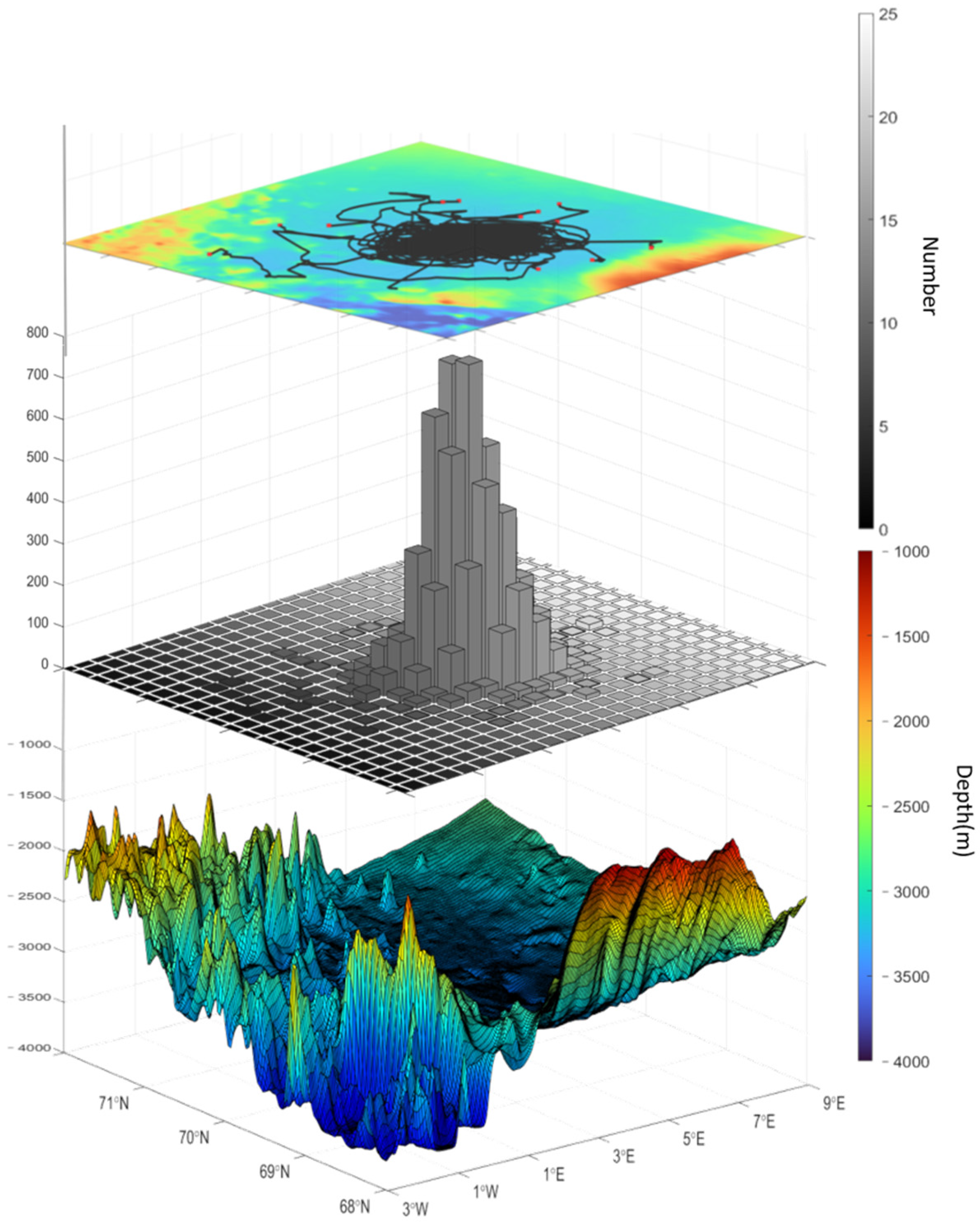
The results suggest that the LV is a collective term for the mesoscale eddies that are generated and maintained within the deepest depressions of the LB (Figure 3), with the exception of a small number of eddies with initial positions to the northwest before “becoming” the LV. The trajectories of the LV were concentrated in the range of 0.5°E–6°E, 69°N–70.5°N and revolved around the center (70°N, 3°E). The overall trajectories exhibited an elliptical shape, with the northwest–southeast direction representing the long axis and the southwest–northeast direction representing the short axis. The frequency of occurrence at the center position was approximately cone-shaped and symmetrical, with 70°N, 3°E as the center. A slight increase in the west and a slight decrease in the east were observed. During the period between 1995 and 2019, the LV tended to disappear and then regenerate, occurring five times in total. This behavior can be described as “quasi-permanent”.

3.2. Merging Event

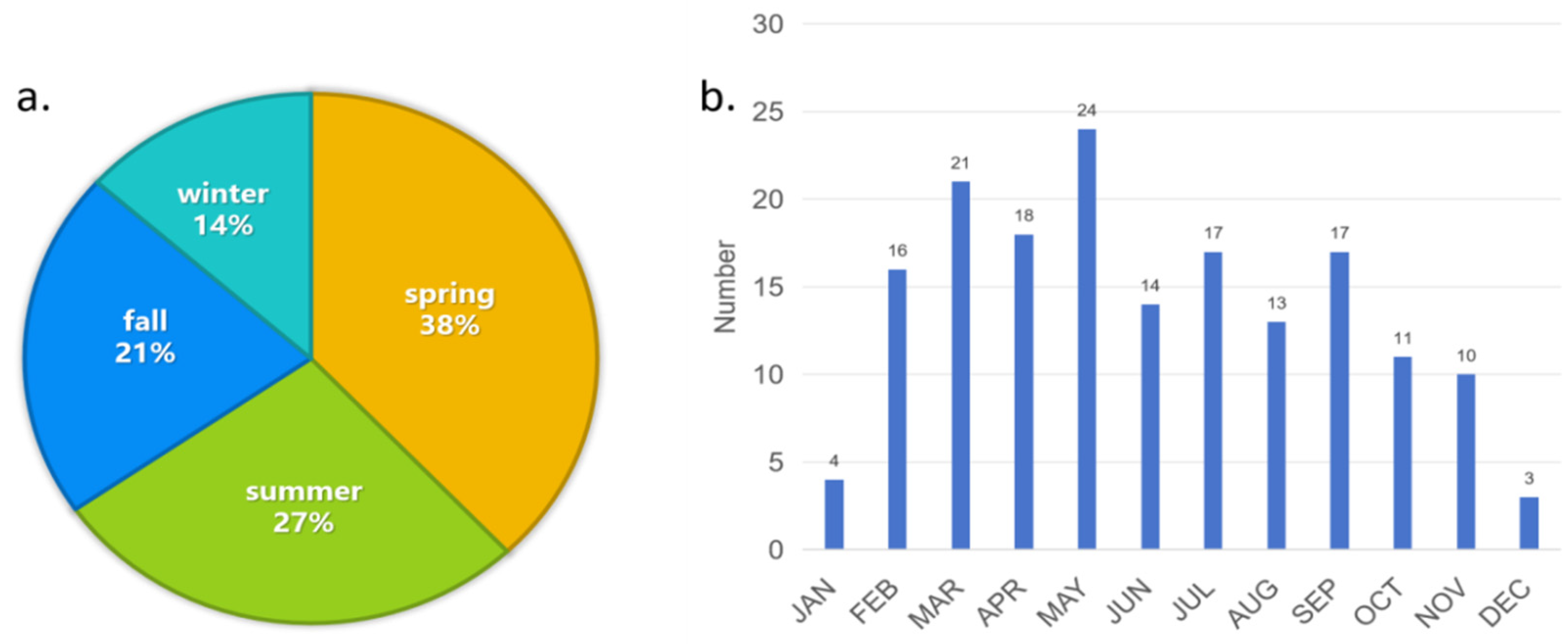
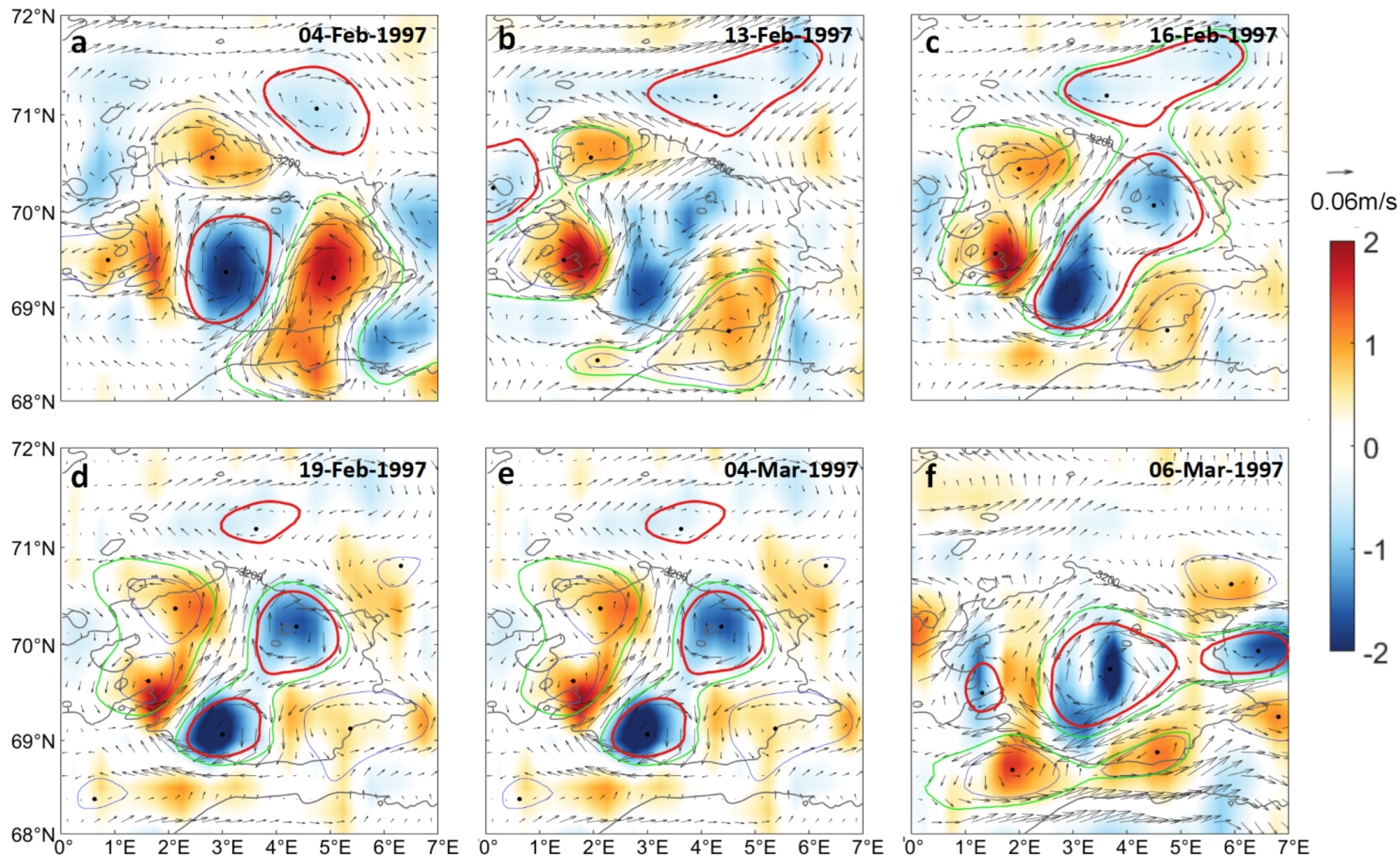
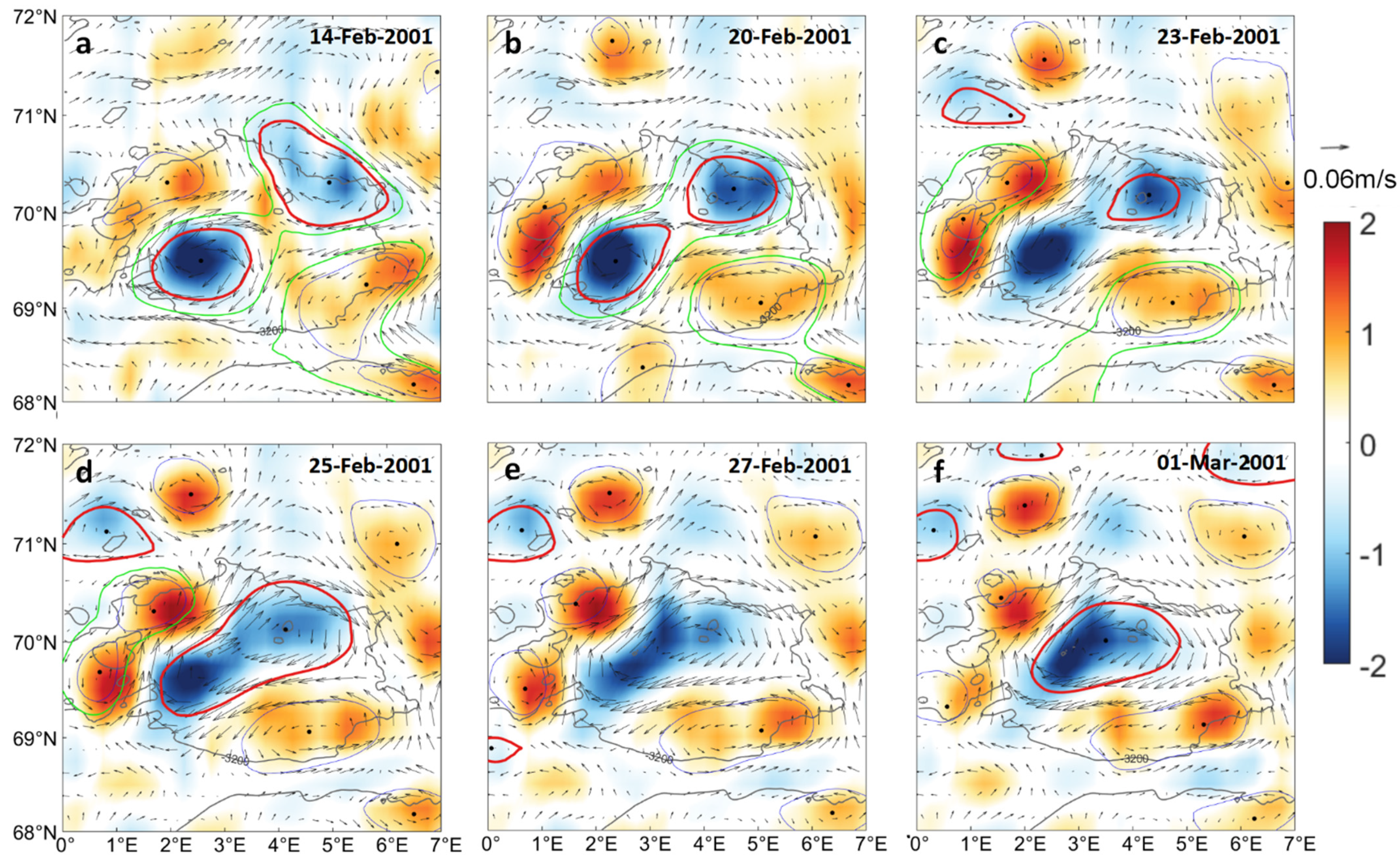
During 1995–2019, the AMEDA method identified 179 merging events. Seasonally, 65% of the merging events occurred in the spring and summer (March–April–May and June–July–August) seasons, with spring accounting for the largest number of events at 38%. In comparison, the fall and winter seasons (September–October–November and December–January–February) accounted for a total of 35% of the events, as shown in Figure 4. The observed increase in LV strength during winter and spring, and the subsequent decrease during summer, indicate that there is no discernible correlation between the intensity of LV activity and the occurrence of eddy merging events. Among the merging events in spring and summer, the LV and the neighboring cyclones were stronger in spring and weaker in summer [33], resulting in a significant difference in vortex merging. We categorized the vortex-merging events into three types based on the duration and impact on the vortex: normal merging, vortex fluctuation, and vortex substitution. In this study, the term “ordinary merging events” is used to describe the process by which the LV merges with other anticyclonic eddies. These events can be categorized further into two distinct types, depending on the strength of the merged anticyclonic eddy. The characteristics of these two types will be discussed in greater detail later in this study. Individual cases of the LV fluctuations entail the splitting and subsequent re-merging of the vortex within a relatively short period—approximately one to two weeks (Figure 5). Four such cases were identified over the course of 25 years. The LV substitution events (Figure 6) were more distinctive, where the LV is engulfed by a more powerful external anticyclone, which then becomes a new LV in situ. The substitution occurred at the same time on five occasions over 25 years. Such occurrences suggest a destabilization of the spatial and temporal characteristics of the vortex, which is typically regarded as a stable entity.

3.3. The Sea Surface Characteristics of Vortex Merging

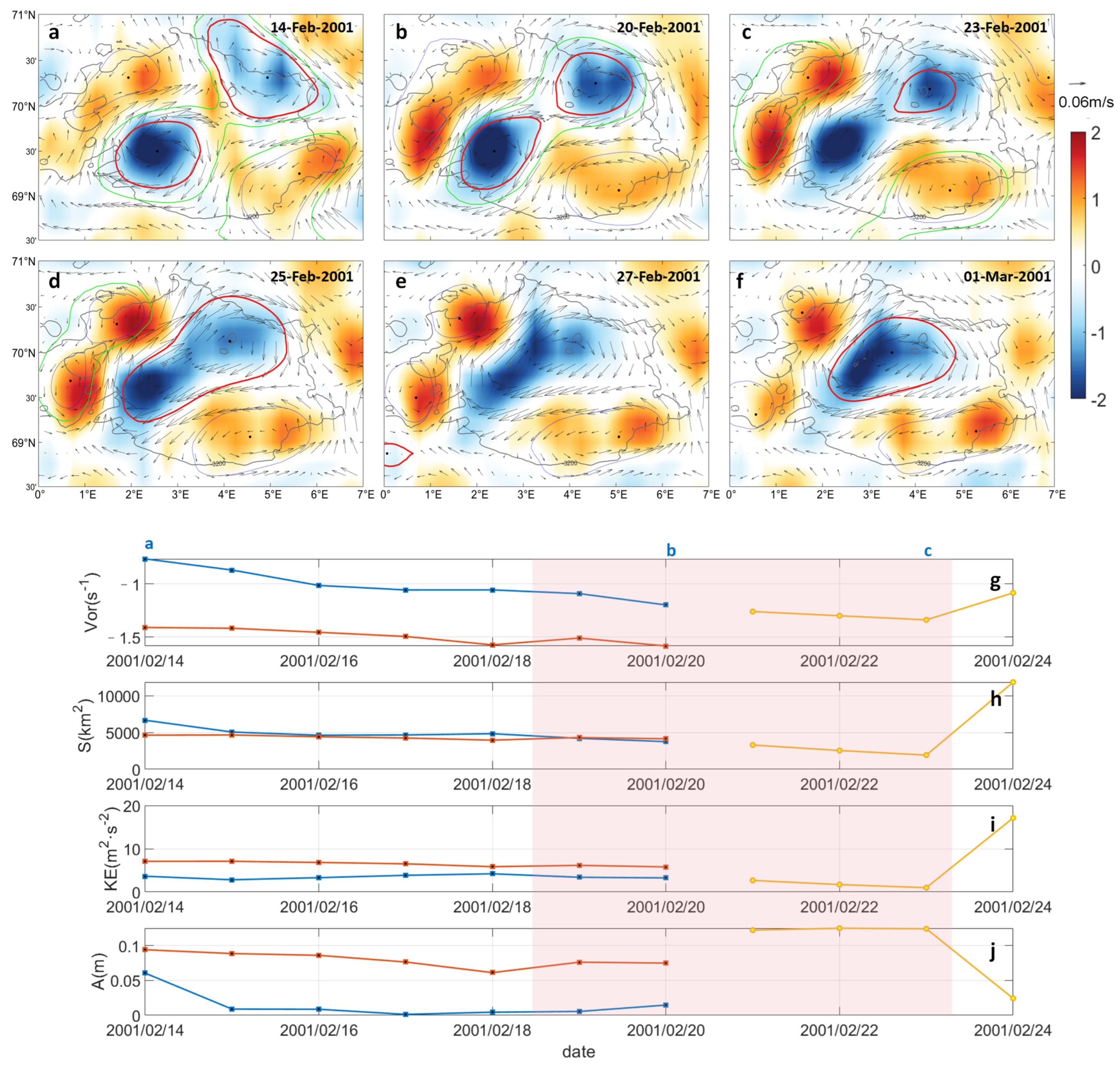
The common merging events of the LV can be divided into two categories: the merging of the LV with an anticyclone of comparable strength (Figure 7) and the merging of the LV with a relatively weak anticyclone (Figure 8). Using the AMEDS method, these two types were classified based on the different variations in the closed streamlines. In the fusion event, two eddies first lose their closed streamlines and are no longer recognized as eddies until the fusion is complete. Finally, the new eddy regenerates the closed streamlines. In the absorption event, the LV is stronger and directly engulfs or absorbs the weaker eddy after destroying it. In the whole process, the LV does not lose the closed streamline. The characteristics and processes of these fusion events have been well-reproduced and studied in rotating pool experiments [34]. The anticyclone is constantly approaching the LV, creating a common flow line, and the two are connected by a narrow “channel”. The two merge through slow diffusion and mutual absorption, leading to an exchange of vorticity between them. Eventually, they rapidly approach each other, transforming from a multinuclear to a mononuclear vortex structure [34,35]. This type of merging process can be described as the fusion of two eddies within the same closed streamline in interaction. More intense cyclones tend to exist and interact around such vortex-merging events and, by the end of the fusion, the cyclonic eddies will have formed a more stable shielding ring around the LV.
We divided the fusion process into three stages: before, during, and after. Before the fusion event, the total vorticity, total kinetic energy, and area within the characteristic streamlines of the two eddies remain stable. At the same time, the amplitude of the anticyclone weakens, characterizing the structure of the anticyclone as loosening. During the fusion event, the two eddies interact, resulting in a decrease in both area and kinetic energy, while the vorticity increases and the amplitude of the LV weakens. Conversely, the amplitude of the resulting eddy increases. Upon completion of the fusion process, the vorticity, area, and kinetic energy of the resulting LV are significantly reduced and subsequently stabilized. Previous studies have shown that this may be due to the consumption of energy through the formation of new closed streamlines [28]. Quantitative results of the stabilization of the LV space field subsequent to transient deformation are shown in Figure 7g–j.
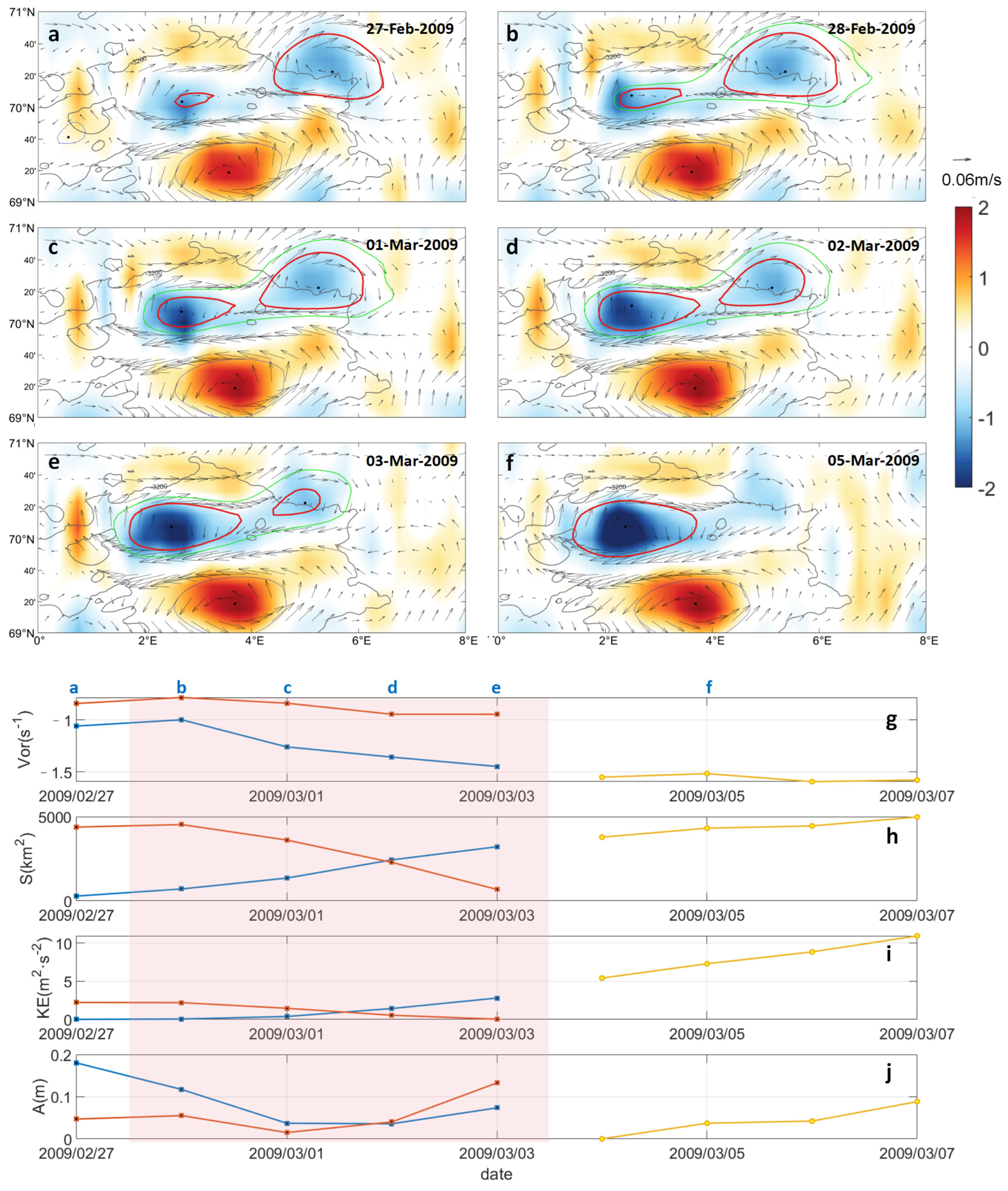
The former example of eddy fusion occurred in a shielded ring of several strong cyclones, which facilitated the fusion of the two eddies. In contrast, the latter example of merging has no such background field. Between 27 February and 7 March 2009, the small LV merged with a larger anticyclone (Figure 8). At this time, a stronger cyclone was located to the south of the two anticyclones, locally stabilizing them in concert with the positive vorticity to the north. Although small in size, the LV continued to absorb the anticyclone after contact with it until the anticyclone disappeared completely. Although it appears that the small eddy absorbed the large eddy, the overall characteristics of the change in vorticity, area, kinetic energy, and amplitude over the course of the merging event indicate that the vorticity of the LV was stronger than that of the eastern anticyclone eddy before the merger. It maintained this dominance throughout the merging event. The area, kinetic energy, and amplitude of the LV and the merged anticyclone increased monotonically until the end of the merger.
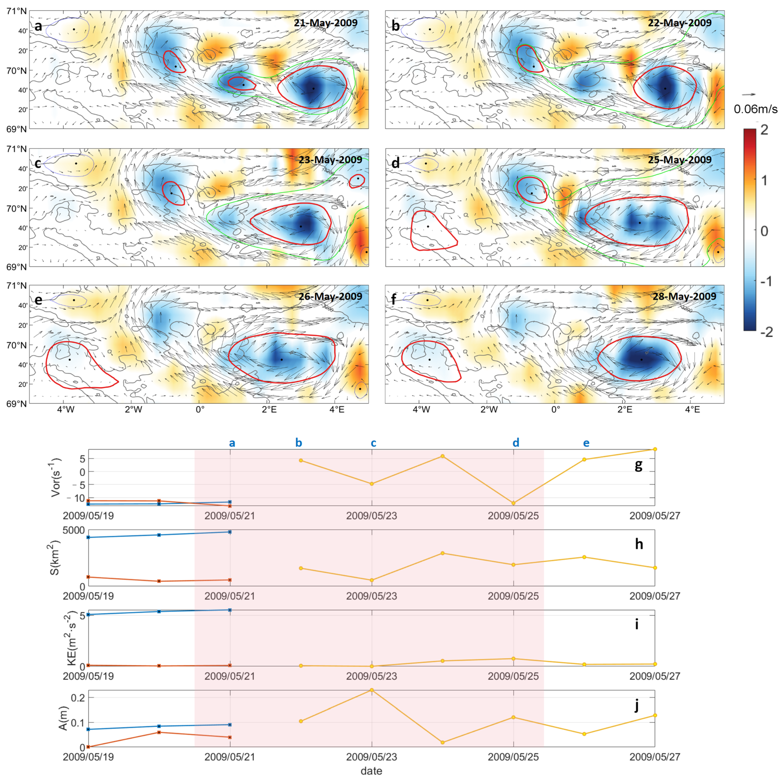
The vortex-merging event that occurred between 19 May and 27 May 2009 was a typical individual case of a strong LV merging with a weak anticyclonic eddy, as shown in Figure 9. After the anticyclonic eddy approached the LV, the closing streamline disappeared within 1 to 2 days and was engulfed quickly by the LV. No cyclonic eddy around the two anticyclonic eddies could be observed in the background vorticity field, and the positive vorticity was also weak.
The time series demonstrates that the area and kinetic energy of the two anticyclonic eddies exhibited significant differences and underwent minimal change throughout the merging process. In contrast, the vorticity and amplitude displayed notable dissimilarities, and the merging event occurred with remarkable rapidity. The merged LV was also subject to the influence of the flow field of the smaller anticyclonic eddy, which presented fluctuations.
The two vortex-merging events with area differences can be classified as strong eddies absorbing weak eddies. A comparison of the temporal changes in vorticity, area, kinetic energy, and amplitude of the two merging events reveals that the strength of the LV undergoes a fluctuating change, exhibiting a brief weakening followed by strengthening of the eddy. This fluctuating change is a consequence of the interaction of energy from the other (entering) eddies. However, this fluctuation is less pronounced when the LV absorbs a large eddy when compared to a small-area eddy, and the overall trend is one of steady strengthening.
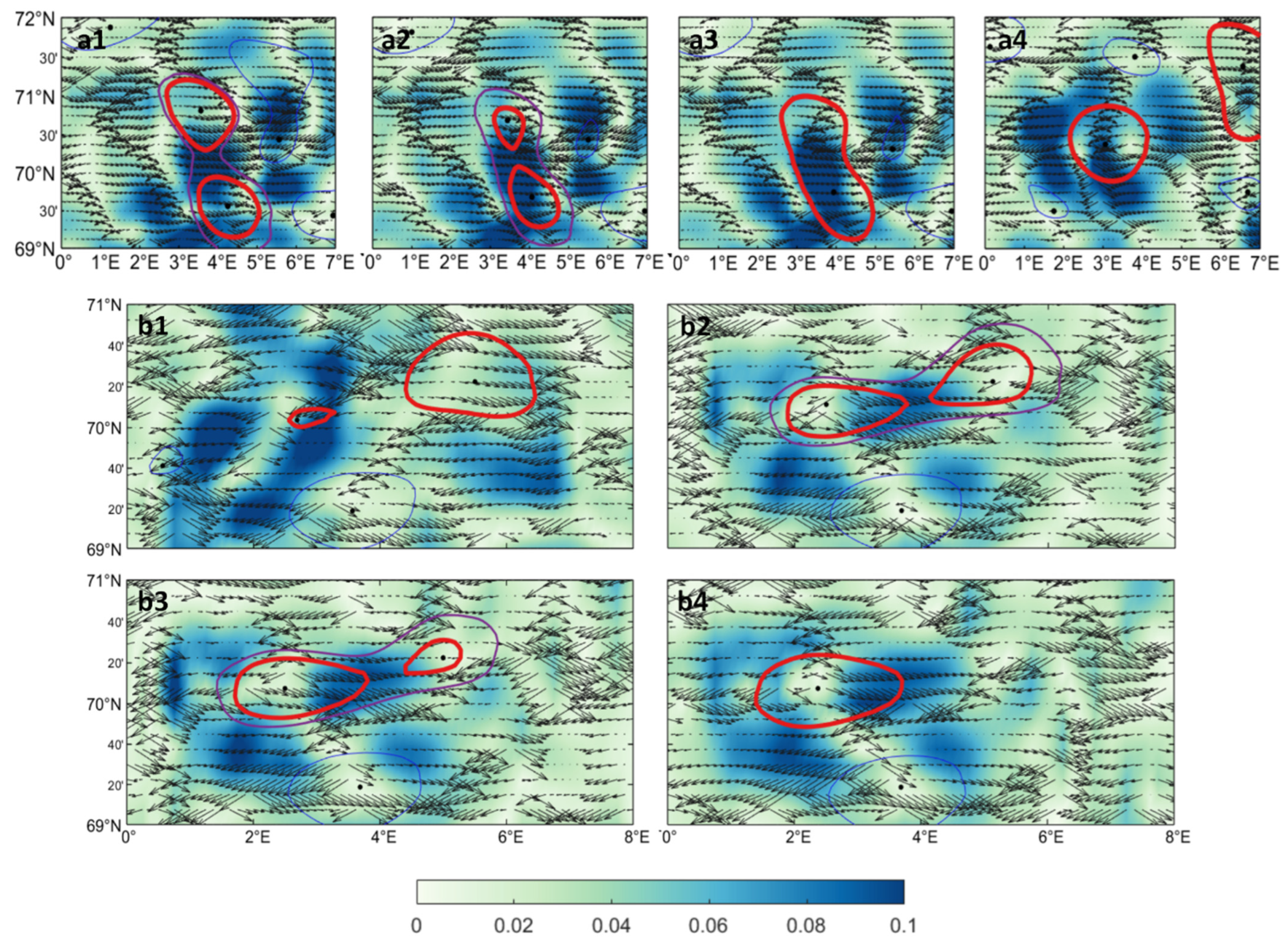
The merging time of the LV absorbing a small eddy is relatively brief. In this study, only the changes in the characteristic parameters (normalized strain rate and strain direction) during the fusion event and the absorption of the large eddy were considered.
A strong strain can be observed between the two eddies during the fusion event (Figure 10a). Prior to the onset of fusion, the direction of strain between the eddies points from the fused eddy to the LV. The fused eddy undergoes stronger deformation at this stage, and the direction of deformation points towards the LV. The strain direction within the LV is random at this point, and its deformation is weaker. Subsequently, the strain rate between the eddies increases, and the region of strong strain extends towards the location of the LV. At this stage, the strain direction within the fused eddy begins to point from the sides to the center of the eddy, and the eddies lose their closed streamlines and begin to interact in a shared streamline. At this time, the strain direction of the upper part of the fused eddy continues to point to the center, while the lower part has a strong strain pointing to the southeast. Eventually, the new LV stabilizes in a more northerly position, while the vorticity in the southern region of the strong strain breaks away from this new vortex.
In the case of the large vortex event, as illustrated in Figure 10b, the same strong strain is evident between the two eddies prior to the onset of merging. The LV is relatively small, and the direction of strain within it is aligned predominantly with the region of strong strain. The merged eddy is larger, but it exhibits a random strain direction. During the merging process, the LV extends towards the region of strong strain and absorbs the merged eddy, ultimately leading to its complete disappearance.
In the merging event, the two eddies are of comparable strength, and the merged eddy deforms while interacting with the LV. The destructive effect of this deformation fuels the vortex merging. In the absorption event, the LV deforms more strongly, and the strain effect causes it to extend in the direction of the merged eddy.
Merging events are classified according to their duration and impact on the LV, as illustrated in Figure 11. In particular, merging events are classified into two main categories: ordinary merging events and vortex substitution and fluctuation events. The large number of generalized merging events can be subdivided into two types of events: fusion events, which occur between two eddies of comparable size and strength; and absorption events, which occur between two eddies with significant disparities in size and strength. In the first type, two eddies of comparable size and intensity fuse into a single eddy after losing their independent closed streamlines and rapidly approaching each other surrounded by shared streamlines. They then fuse into a single eddy in a strong interaction. In the second type, the stronger eddy continues to absorb the weaker eddy, ultimately leading to its complete extinction. The weaker eddy’s set of separate closed streamlines cease to exist only after it has been completely absorbed.
Approximately 55% of all ordinary merging events are fusion events, while approximately 45% are absorption events. As anticyclonic eddies tend to intensify upon entering the LB depression topography, the proportion of events illustrates that anticyclonic eddies entering the LB ocean are more likely to be weaker than the LV than of comparable strength.

3.4. The Sea Surface Characteristics of Vortex Substitution

The quasi-permanence of the LV is maintained due to the enhancement of other eddies undergoing merging and the contribution of strong vertical mixing during the winter season. However, the effect of merging events is not limited to the enhancement of the LV itself; in some special cases, the LV also disappears as other eddies subsume it. The external anticyclonic eddy remains in the local area, “inherits” the position of the quasi-permanent anticyclonic eddy, and becomes the new LV. A case-by-case analysis was conducted to examine this particular type of merging process further.
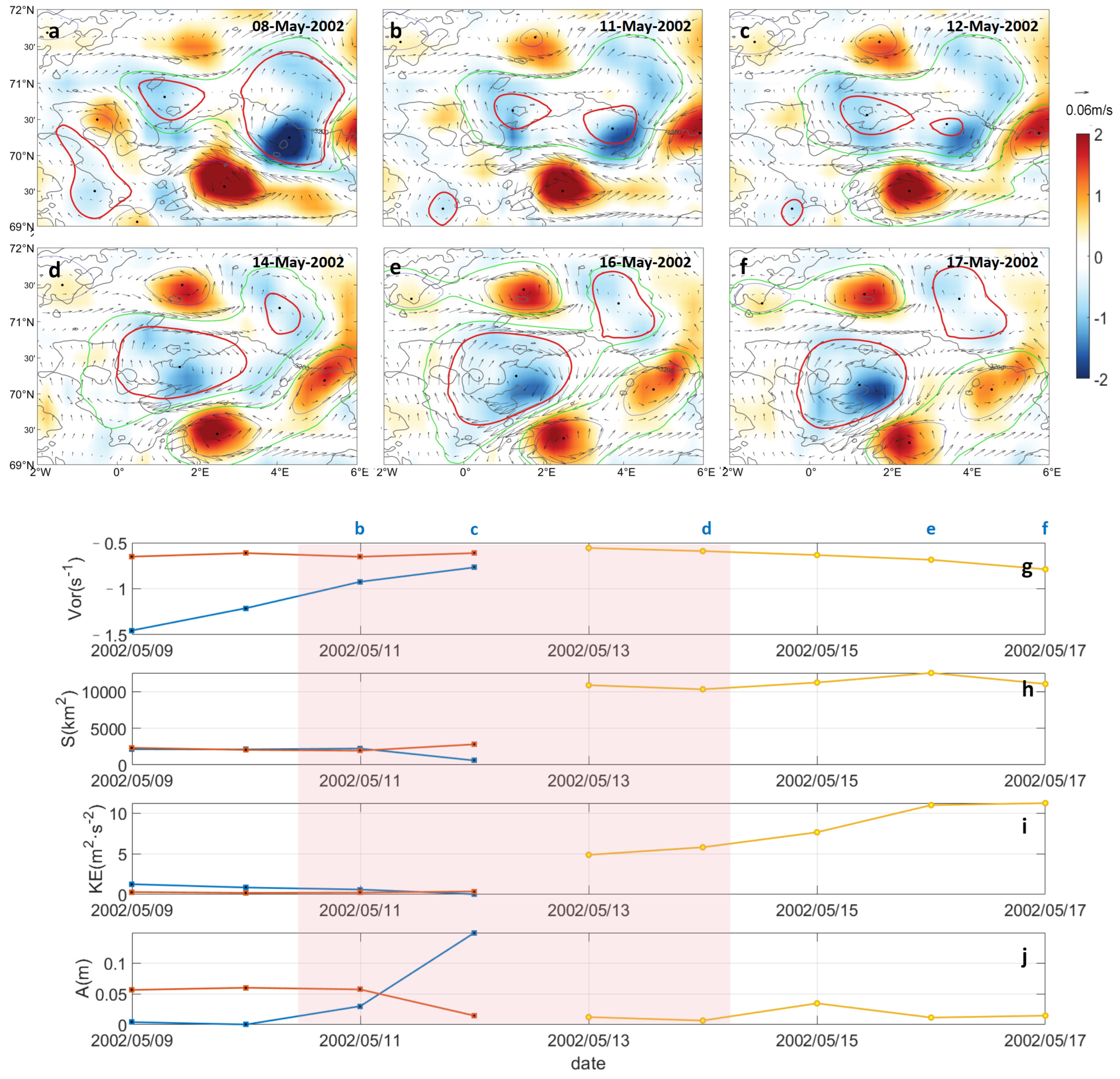
Theoretically, a smaller eddy—even if it is more powerful—would have difficulty subsuming a larger eddy, as evidenced by the previously mentioned case of the LV, which was both strong and small in size. Our findings indicate that this disparity in size does not necessarily indicate a disparity in strength. However, in the case of May 2002, when the LV was merging, the new eddy was weaker than the LV in almost all of its characteristics (Figure 12). The weak eddy was able to merge with the LV due to the inherent tendency of the LV to split at the time of the merging of the two eddies, even before the two eddies appeared to share a streamline. In the spatial vorticity field observed on 8 May 2002, there was already a tendency to split within the LV and, after that, the eddy split into two parts, which continued to weaken in strength. One part was comparable in strength to the growing new eddy and was ultimately absorbed by the new eddy as a result of interactions, which allowed the new eddy to continue to strengthen. The remaining portion absorbed the vorticity lost during the merging event.
An additional category of examples can be observed between two eddies of comparable strength (Figure 13). Typically, the two eddies do not interact separately after the appearance of the shared flow line. Instead, they directly become one large eddy and then continue to interact in this large eddy before finally reaching stabilization. Ascertaining the strength of the two eddies solely based on the spatial field is challenging. However, the time series provides a more nuanced understanding. Despite the minor discrepancy in the area of the two eddies, the vorticity and kinetic energy of the nascent eddy are predominantly stronger than those of the LV. Moreover, the new eddy exhibits a strengthening trend during the merging process, whereas the LV displays a weakening tendency. Substitution events bear a resemblance to merging events, with the distinction that the original LV exhibits a comparatively weaker position in these events, ultimately resulting in its incorporation into the merging entity.

4. Discussion

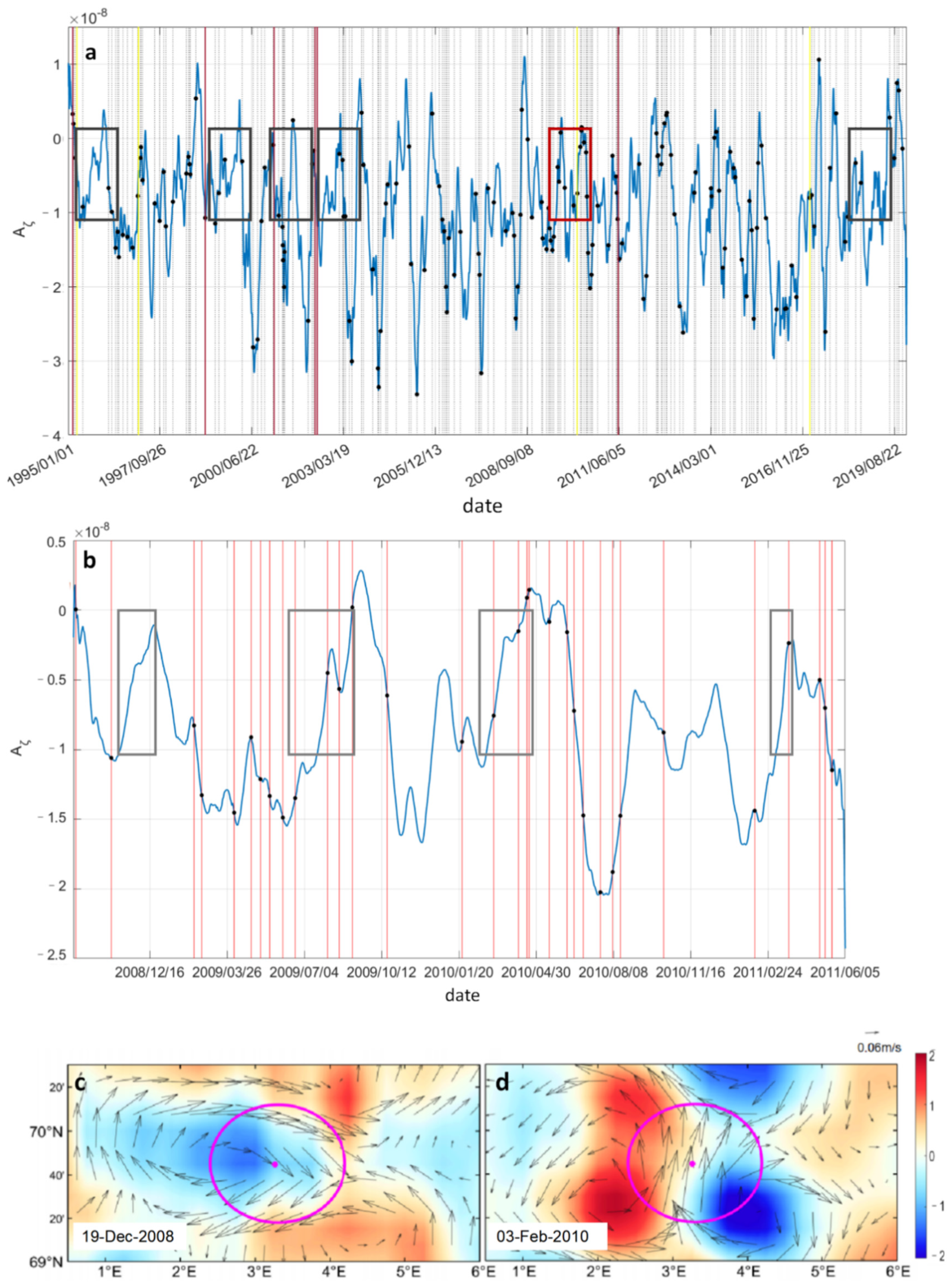
The active range of the LV is defined as 0.5°E–6°E, 69°N–70.5°N (Figure 14), and we used vorticity advection to characterize the effects produced by the entry of external eddies.
Regional vorticity advection can characterize the input of positive and negative vorticity in the region. This vorticity input is manifested within the LV range with the entry of cyclonic and anticyclonic eddies. An example of merging can be observed when an anticyclonic eddy carrying negative vorticity enters the active range of the LV. Consequently, regional vorticity advection is characterized by negative vorticity reaching an extreme value. Furthermore, it has been demonstrated that, if the intensity of surrounding cyclones increases before and after the merging of an anticyclonic eddy, these cyclones will interact with the anticyclone or influence the surrounding circulation. This interaction will then affect the vortex merging, resulting in a positive vorticity reaching an extreme value. The nodes at which the aforementioned changes occur correspond to the nodes at which the merging event occurs, suggesting that their influence on the merging event can be well characterized by the time series of vorticity advection.
The presence of very strong positive and negative vorticity advection in the region is indicative of strong cyclonic and anticyclonic eddies, and such a background favors vortex-merging events. As the computed vorticity advection represents a regional average, when the positive eddy input is stronger than the negative eddy, the latter will exhibit a weakening, resulting in two distinct scenarios. In the first scenario, no vortex-merging events occur while, in the second, a significant number of vortex-merging events occur relative to the same feature. These occurrences can be attributed to the regionally averaged negative vorticity advection being weakened to near-zero. At this juncture, it is not feasible to characterize these merging events based solely on the time series of vorticity advection. Accordingly, a spatial field analysis of individual cases of vortex merging is required.
The results of our investigation of the sea surface flow field using AVISO data yielded similar conclusions to those of previous authors, in terms of vortex trajectories, quasi-permanent maintenance mechanisms, and other relevant factors. This conclusion suggests that satellite data can be used to obtain sea surface information on the LV, an anticyclone with a core at depth. However, the information that can be derived from sea surface signals is limited. The core of the biconvex lens structure within the LV is located at a certain depth, and the vertical characteristics of the merging anticyclones could not be determined from the satellite data, or whether the merging vortices exhibited the biconvex lens structure or other structures. However, as the majority of these anticyclones were weaker than the LV, their merging will not affect the location of the core of the LV. Some studies have shown that the LV merging also presents a double-core vortex [36,37]. However, this double-core structure only exists for a short period of time before undergoing vertical mixing, ultimately restoring the biconvex lenticular structure. The replacement of the LV by a stronger eddy is only proposed as the result of analyzing the sea surface field based on the satellite data. How this process could destroy the LV core, as well as for how long, need to be further investigated through the use of high-resolution modeling approaches.

5. Conclusions

While the majority of previous studies have used the Eulerian method to study the LV, our investigation used the Lagrangian method to monitor this quasi-permanent anticyclone on a daily basis. Flow field observations from 1995 to 2019 yielded a mean location of the center of the LV at 70°N, 3°E, with a characteristic radius of about 42.72 km (with a standard deviation of 6.21 km), a mean vorticity at the center of the vortex of about −2.23 × 10⁻⁵ s−1 (with a standard deviation of 7.19 × 10⁻⁶ s−1), a difference in SST between the center (8.31 °C, with a standard deviation of 1.66 °C) of the climatological eddy at the surface and the edge of the vortex that averaged about 0.96 °C (with a standard deviation of 0.14 °C), and an absolute dynamic height difference of about 0.31 m (with a standard deviation of 0.07 m). The equivalent circular position (69.3°N–70°N, 2.4°E–4.5°E) coincides with that of the climatological state field. The trajectory tracking results indicated that the LV circles back and forth in the depression region, with a counterclockwise cyclonic rotation.
The incidence of LV merging events is highest during the spring and summer months. The strength of the LV and its neighboring cyclonic eddies is typically high in the spring and relatively low in the summer. Consequently, two strong vortex-merging events often occur in the spring, while two weaker eddies or one stronger and one weaker vortex-merging event occur in the summer. The duration and outcome of the merging event can be classified into several categories. In addition to the numerous ordinary merging events, in which the LV merges with an external anticyclone, there are also a small number of vortex-fluctuating events in the LV and events in which the LV is merged with an external anticyclone. The alternative events indicate that the LV should be considered a collective term for a series of eddies, rather than a single vortex.
The mode of merging determines whether a common merging event can be categorized as fusion or absorption. The fusion of the LV with eddies of comparable strength initially results in the loss of independent closed streamlines, which subsequently interact within the same closed streamline. A strong LV will absorb a weak eddy. Merging and absorption events account for 55% and 45%, respectively, of the total number of merging events. The presence of strong positive and negative vorticity advection in the region indicates the presence of strong cyclonic and anticyclonic eddies in the region, and this background is conducive to the occurrence of eddy merger events. The nodes of strong vorticity advection correspond to the nodes of merger events, indicating that their effects on merger events can be well characterized by the vorticity advection time series.

Author Contributions

Conceptualization, Y.L. and J.M.; funding acquisition, Y.L.; methodology, J.M. and G.H.; project administration, Y.L.; validation, J.M.; visualization, J.M. and G.H.; writing—original draft, J.M. and Y.L.; writing—review and editing, Y.L., G.H., X.L. and J.X. All authors have read and agreed to the published version of the manuscript.

Funding

This study was supported by the National Natural Science Foundation of China (Project Nos. 42376004, 42206004, 42206005) and the Southern Marine Science and Engineering Guangdong Laboratory (Zhuhai) (Grant SML2020SP007).

Data Availability Statement

Data are contained within the article.

Conflicts of Interest

The authors declare no conflicts of interest.

References

  1. Blindheim, J.; Rey, F. Water-mass formation and distribution in the nordic seas during the 1990s. ICES J. Mar. Sci. 2004, 61, 846–863. [Google Scholar] [CrossRef]
  2. Boyer, T.P.; Levitus, S.; Antonov, J.; Locarnini, R.; Garcia, H. Linear trends in salinity for the world ocean, 1955–1998. Geophys. Res. Lett. 2005, 32, L01604. [Google Scholar] [CrossRef]
  3. Nilsen, J.E.Ø.; Nilsen, F. The atlantic water flow along the vøring plateau: Detecting frontal structures in oceanic station time series. Deep-Sea Res. Part I 2007, 54, 297–319. [Google Scholar] [CrossRef]
  4. Segtnan, O.; Furevik, T.; Jenkins, A. Heat and freshwater budgets of the nordic seas computed from atmospheric reanalysis and ocean observations. J. Geophys. Res. Oceans 2011, 116, C11003. [Google Scholar] [CrossRef]
  5. Bosse, A.; Fer, I.; Lilly, J.M.; Søiland, H. Dynamical controls on the longevity of a non-linear vortex: The case of the lofoten basin eddy. Sci. Rep. 2019, 9, 13448. [Google Scholar] [CrossRef]
  6. Spall, M.A.; Almansi, M.; Huang, J.; Haine, T.W.; Pickart, R.S. Lateral redistribution of heat and salt in the nordic seas. Progr. Oceanogr. 2021, 196, 102609. [Google Scholar] [CrossRef]
  7. Mayot, N.; Matrai, P.; Arjona, A.; Bélanger, S.; Marchese, C.; Jaegler, T.; Ardyna, M.; Steele, M. Springtime export of arctic sea ice influences phytoplankton production in the greenland sea. J. Geophys. Res. Oceans 2020, 125, e2019JC015799. [Google Scholar] [CrossRef]
  8. Rossby, T.; Prater, M.; Søiland, H. Pathways of inflow and dispersion of warm waters in the nordic seas. J. Geophys. Res. Oceans 2009, 114, C04011. [Google Scholar] [CrossRef]
  9. Björk, G.; Gustafsson, B.G.; Stigebrandt, A. Upper layer circulation of the nordic seas as inferred from the spatial distribution of heat and freshwater content and potential energy. Polar. Res. 2001, 20, 161–168. [Google Scholar] [CrossRef]
  10. Volkov, D.L.; Belonenko, T.V.; Foux, V.R. Puzzling over the dynamics of the lofoten basin-a sub-arctic hot spot of ocean variability. Geophys. Res. Lett. 2013, 40, 738–743. [Google Scholar] [CrossRef]
  11. Nilsen, J.E.Ø.; Falck, E. Variations of mixed layer properties in the norwegian sea for the period 1948–1999. Progr. Oceanogr. 2006, 70, 58–90. [Google Scholar] [CrossRef]
  12. Raj, R.P.; Johannessen, J.A.; Eldevik, T.; Nilsen, J.E.Ø.; Halo, I. Quantifying mesoscale eddies in the Lofoten Basin. J. Geophys. Res. Oceans 2016, 121, 4503–4521. [Google Scholar] [CrossRef]
  13. Sandalyuk, N.V.; Bosse, A.; Belonenko, T.V. The 3-d structure of mesoscale eddies in the lofoten basin of the norwegian sea: A composite analysis from altimetry and in situ data. J. Geophys. Res. Oceans 2020, 125, e2020JC016331. [Google Scholar] [CrossRef]
  14. Furevik, T.; Mauritzen, C.; Ingvaldsen, R. The flow of Atlantic water to the Nordic Seas and Arctic Ocean. In Arctic Alpine Ecosystems and People in a Changing Environment; Ørbæk, J.B., Kallenborn, R., Tombre, I., Hegseth, E.N., Falk-Petersen, S., Hoel, A.H., Eds.; Springer: Berlin/Heidelberg, Germany, 2007; pp. 123–146. [Google Scholar]
  15. Belonenko, T.V.; Volkov, D.L.; Norden, Y.E.; Ozhigin, V.K. Water circulation in the lofoten basin of the norwegian sea. Vest. St. Petersburg. Univ. 2014, 7, 108–121. [Google Scholar]
  16. Ivanov, Y.; Korablev, A. Formation and regeneration of the pycnocline lens in the norwegian sea. Russ. Meteorol. Hydrol. 1995, 9, 62–69. [Google Scholar]
  17. Pereskokov, A. On the physical nature of large-scale counter-cyclical cycle in the water column of the norwegian sea. Rep. Acad. Sci. 1999, 364, 549–552. [Google Scholar]
  18. Søiland, H.; Prater, M.; Rossby, T. Rigid topographic control of currents in the nordic seas. Geophys. Res. Lett. 2008, 35, L18607. [Google Scholar] [CrossRef]
  19. Bashmachnikov, I.; Sokolovskiy, M.; Belonenko, T.; Volkov, D.; Isachsen, P.; Carton, X. On the vertical structure and stability of the lofoten vortex in the norwegian sea. Deep-Sea Res. Part I 2017, 128, 1–27. [Google Scholar] [CrossRef]
  20. Liu, Y.; Meng, J.; Wang, J.; Han, G.; Lin, X.; Chen, J.; Ji, Q. Analysis of seasonal and long-term variations in the surface and vertical structures of the lofoten vortex. Remote Sens. 2023, 15, 1903. [Google Scholar] [CrossRef]
  21. Alexeev, G.; Bagryantsev, M.; Bogorodsky, P.; Vasin, V.; Shirokov, P. Structure and circulation of water masses in the area of an anticyclonic vortex in the north-eastern part of the norwegian sea. Russ. Probl. Arct. Antarct. 1991, 65, 14–23. [Google Scholar]
  22. Köhl, A. Generation and stability of a quasi-permanent vortex in the lofoten basin. J. Phys. Oceanogr. 2007, 37, 2637–2651. [Google Scholar] [CrossRef]
  23. Travkin, V.S.; Belonenko, T.V. Seasonal variability of mesoscale eddies of the Lofoten Basin using satellite and model data. Russ. J. Earth Sci. 2019, 19, ES5004. [Google Scholar] [CrossRef]
  24. Ivanov, Y.; Korablev, A. Dynamics of an intrapycnocline lens in the Norwegian sea. Russ. Meteorol. Hydrol. 1995, 10, 32–37. [Google Scholar]
  25. Wang, Z.; Sun, L.; Li, Q.; Cheng, H. Two typical merging events of oceanic mesoscale anticyclonic eddies. Ocean Sci. 2019, 15, 1545–1559. [Google Scholar] [CrossRef]
  26. Qiu, C.; Mao, H.; Liu, H.; Xie, Q.; Yu, J.; Su, D.; Ouyang, J.; Lian, S. Deformation of a warm eddy in the northern South China Sea. J. Geophys. Res. Oceans 2019, 124, 5551–5564. [Google Scholar] [CrossRef]
  27. Qiao, J.; Qiu, C.; Wang, D.; Huang, Y.; Zhang, X. Multi-stage development within anisotropy insight of an anticyclone eddy in northwestern South China Sea in 2021. Geophys. Res. Lett. 2023, 50, e2023GL104736. [Google Scholar] [CrossRef]
  28. Volkov, D.L.; Kubryakov, A.A.; Lumpkin, R. Formation and variability of the lofoten basin vortex in a high-resolution ocean model. Deep-Sea Res. Part I 2015, 105, 142–157. [Google Scholar] [CrossRef]
  29. Chelton, D.B.; Schlax, M.G.; Samelson, R.M.; de Szoeke, R.A. Global observations of large oceanic eddies. Geophys. Res. Lett. 2007, 34, 15. [Google Scholar] [CrossRef]
  30. Nencioli, F.; Dong, C.; Dickey, T.; Washburn, L.; McWilliams, J.C. A vector geometry–based eddy detection algorithm and its application to a high-resolution numerical model product and high-frequency radar surface velocities in the southern california bight. J. Atmos. Ocean. Technol. 2010, 27, 564–579. [Google Scholar] [CrossRef]
  31. Mkhinini, N.; Coimbra, A.L.S.; Stegner, A.; Arsouze, T.; Taupier-Letage, I.; Béranger, K. Long-lived mesoscale eddies in the eastern mediterranean sea: Analysis of 20 years of aviso geostrophic velocities. J. Geophys. Res. Oceans 2014, 119, 8603–8626. [Google Scholar] [CrossRef]
  32. Le Vu, B.; Stegner, A.; Arsouze, T. Angular momentum eddy detection and tracking algorithm (ameda) and its application to coastal eddy formation. J. Atmos. Ocean. Technol. 2018, 35, 739–762. [Google Scholar] [CrossRef]
  33. Koszalka, I.; LaCasce, J.; Andersson, M.; Orvik, K.; Mauritzen, C. Surface circulation in the nordic seas from clustered drifters. Deep-Sea Res. Part I 2011, 58, 468–485. [Google Scholar] [CrossRef]
  34. Fu, M.; Han, G.; Lu, X.; Sun, W.; Sommeria, J.; Stegner, A.; Caldeira, R.M.; Dong, C. Analysis of vortex merging from a rotating tank laboratory experiment. Progr. Oceanogr. 2024, 222, 103227. [Google Scholar] [CrossRef]
  35. Fu, M.; Dong, C.; Dong, J.; Sun, W. Analysis of mesoscale eddy merging in the subtropical northwest pacific using satellite remote sensing data. Remote Sens. 2023, 15, 4307. [Google Scholar] [CrossRef]
  36. Trodahl, M.; Isachsen, P.E.; Lilly, J.M.; Nilsson, J.; Kristensen, N.M. The regeneration of the lofoten vortex through vertical alignment. J. Phys. Oceanogr. 2020, 50, 2689–2711. [Google Scholar] [CrossRef]
  37. Belkin, I.; Foppert, A.; Rossby, T.; Fontana, S.; Kincaid, C. A double-thermostad warm-core ring of the gulf stream. J. Phys. Oceanogr. 2020, 50, 489–507. [Google Scholar] [CrossRef]
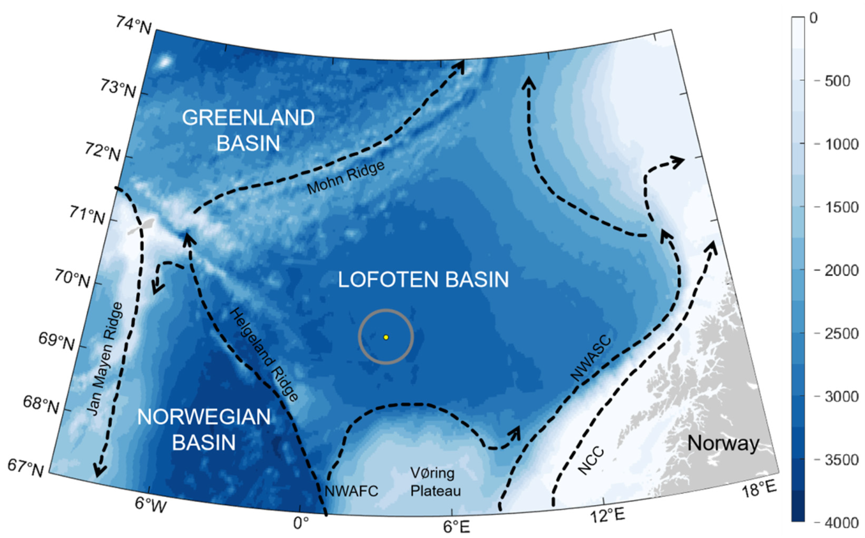
Figure 1. Bottom topography (filled colors, units: m) and general circulation (arrows) of the LB and the surrounding region. The gray circle marks the position of the Lofoten eddy. Abbreviations: NCC—Norwegian Coastal Current, NwASC—Norwegian Atlantic Slope Current, NwAFC—Norwegian Atlantic Frontal Current.
Remotesensing 16 03796 g001
Figure 2. Climatic state of the LB sea area in the period 1995–2022: (a) ADT field, (b) SST field, and (c) vorticity field. The data sources are daily AVISO height field and geostrophic current field data, as well as monthly AVHRR SST data from 1 January 1995 to 31 December 2022.
Remotesensing 16 03796 g002
Figure 3. Topography of the LB (bottom), frequency of the LV centroid ((middle), value is the product of the height of the bar graph and the color of the bar), and the LV motion track (top). Daily results from 1 January 1995 to 31 December 2019. Colors are topographic depths (units: m, shared between the upper and lower plots), black lines are vortex motion tracks, and red dots are the farthest locations of the LV motion.
Remotesensing 16 03796 g003
Figure 4. Merging event statistics: (a) seasonal probability of merging event occurrence; and (b) monthly bar chart showing the number of merging events.
Remotesensing 16 03796 g004
Figure 5. (af) Examples of LV fluctuations. Contour lines indicate bathymetric depth (units: m), filled colors denote vorticity (units: 10−5 s−1), vector arrows represent geostrophic flow fields, red circles indicate characteristic streamlines of anticyclonic eddies, blue circles represent characteristic streamlines of cyclonic eddies, green circles represent shared streamlines between eddies, and solid black dots indicate eddy center positions.
Remotesensing 16 03796 g005
Figure 6. (af) Examples of LV substitution. Contour lines indicate bathymetric depth (units: m), filled colors denote vorticity (units: 10−5 s−1), vector arrows represent geostrophic flow fields, red circles indicate characteristic streamlines of anticyclonic eddies, blue circles denote characteristic streamlines of cyclonic eddies, green circles represent shared streamlines between eddies, and solid black dots indicate eddy center positions.
Remotesensing 16 03796 g006
Figure 7. (af) Variation in the spatial vorticity field during the onset of merging of the LV with an anticyclonic eddy of comparable strength. Contours indicate topographic depth (unit: m), filled colors indicate vorticity (unit: 10−5 s−1), vector arrows indicate the geostrophic flow field, red circles indicate the characteristic flow lines of the anticyclonic eddy, blue circles indicate the characteristic flow lines of the cyclonic eddy, green circles indicate the flow lines shared by the two eddies, and the solid black dots indicate the center of the eddy. (gj) Temporal changes in mean vorticity, area, mean kinetic energy, and amplitude within the eddy before and after the merging event. The blue solid line indicates the LV, the red solid line indicates the merged anticyclonic eddy, the yellow solid line indicates the LV after merging and the merging periods with pink color shading.
Remotesensing 16 03796 g007
Figure 8. Example of the merging between the LV and a significantly larger eddy: (af) Variation in the spatial vorticity field. Contours indicate topographic depth (unit: m), filled colors indicate vorticity (unit: 10−5 s−1), vector arrows indicate the geostrophic flow field, red circles indicate the characteristic flow lines of the anticyclonic eddy, blue circles indicate the characteristic flow lines of the cyclonic eddy, green circles indicate the flow lines shared by the two eddies, and the solid black dots indicate the center of the eddy. (gj) Temporal changes in mean vorticity, area, mean kinetic energy, and amplitude within the eddy before and after the merging event. The blue solid line indicates the LV, the red solid line indicates the merged anticyclonic eddy, the yellow solid line indicates the LV after merging and the merging periods with pink color shading.
Remotesensing 16 03796 g008
Figure 9. Example of the LV merging with a significantly smaller eddy: (af) Variation in the spatial vorticity field. Contours indicate topographic depth (unit: m), filled colors indicate vorticity (unit: 10−5 s−1), vector arrows indicate the geostrophic flow field, red circles indicate the characteristic flow lines of the anticyclonic eddy, blue circles indicate the characteristic flow lines of the cyclonic eddy, green circles indicate the flow lines shared by the two eddies, and the solid black dots indicate the center of the eddy. (gj) Temporal changes in mean vorticity, area, mean kinetic energy, and amplitude within the eddy before and after the merging event. The blue solid line indicates the LV, the red solid line indicates the merged anticyclonic eddy, the yellow solid line indicates the LV after merging and the merging periods with pink color shading.
Remotesensing 16 03796 g009
Figure 10. Variations in the strain field during the merging process: (a1a4) Strain field during the merging event; and (b1b4) strain field during the absorption event. Colors represent the normalized strain rate of vorticity, while vector arrows indicate the direction of strain. The red circle denotes the characteristic streamline of the anticyclonic eddy, the blue circle represents the characteristic streamline of the cyclonic eddy, the purple circle indicates the shared streamline between the eddies, and the black solid dot marks the center position of the eddy.
Remotesensing 16 03796 g010
Figure 11. Classification diagram of LV merging events and statistical distribution of ordinary vortex-merging events.
Remotesensing 16 03796 g011
Figure 12. Example of the LV merged by a significantly smaller eddy: (af) Variation in the spatial vorticity field. Contours indicate topographic depth (unit: m), filled colors indicate vorticity (unit: 10−5 s−1), vector arrows indicate the geostrophic flow field, red circles indicate the characteristic flow lines of the anticyclonic eddy, blue circles indicate the characteristic flow lines of the cyclonic eddy, green circles indicate the flow lines shared by the two eddies, and the solid black dots indicate the center of the eddy. (gj) Temporal changes in mean vorticity, area, mean kinetic energy, and amplitude within the eddy before and after the merging event. The blue solid line indicates the LV, the red solid line indicates the merged anticyclonic eddy, the yellow solid line indicates the LV after merging and the merging periods with pink color shading.
Remotesensing 16 03796 g012
Figure 13. Example of the LV merged by an eddy of comparable size: (af) Variation in the spatial vorticity field. Contours indicate topographic depth (unit: m), filled colors indicate vorticity (unit: 10−5 s−1), vector arrows indicate the geostrophic flow field, red circles indicate the characteristic flow lines of the anticyclonic eddy, blue circles indicate the characteristic flow lines of the cyclonic eddy, green circles indicate the flow lines shared by the two eddies, and the solid black dots indicate the center of the eddy. (gj) Temporal changes in mean vorticity, area, mean kinetic energy, and amplitude within the eddy before and after the merging event. The blue solid line indicates the LV, the red solid line indicates the merged anticyclonic eddy, the yellow solid line indicates the LV after merging and the merging periods with pink color shading.
Remotesensing 16 03796 g013
Figure 14. (a) Time series of vorticity advection from 1995 to 2019, with the blue line indicating the vorticity advection value (unit: s−2), the black dot and black dashed line indicating the period when the merging event occurred, the red solid line indicating the period when the substitution event occurred, the yellow solid line indicating the period when the composite event occurred and the black boxes indicating relative vorticity advection changes from zero to negative while the red box indicating the same of 2008-08 to 2011-06; (b) Time series of vorticity advection from 2008 to 2011, with the blue line indicating the vorticity advection values (unit: s−2), black dots indicating the period when the merging event occurred, red solid lines indicating the period of the merging event and the grey boxes indicating relative vorticity advection changes from zero to negative; (c,d) Comparison of the vorticity field between 19 December 2008, and 3 February 2010. The color denotes the vorticity (unit: 10−5 s−1), vector arrows denote the geostrophic flow field, and the magenta circle and solid dots indicate the climatological position of the LV.
Remotesensing 16 03796 g014
Disclaimer/Publisher’s Note: The statements, opinions and data contained in all publications are solely those of the individual author(s) and contributor(s) and not of MDPI and/or the editor(s). MDPI and/or the editor(s) disclaim responsibility for any injury to people or property resulting from any ideas, methods, instructions or products referred to in the content.