Andean Landscape Legacies: Comprehensive Remote Sensing Mapping and GIS Analysis of Long-Term Settlement and Land Use for Sustainable Futures (NW Argentina)
Abstract
1. Introduction
2. Archaeological Evidence
3. Materials and Methods
4. Interpretation of Results
- (a)
- Diverse aggregation patterns
- (b)
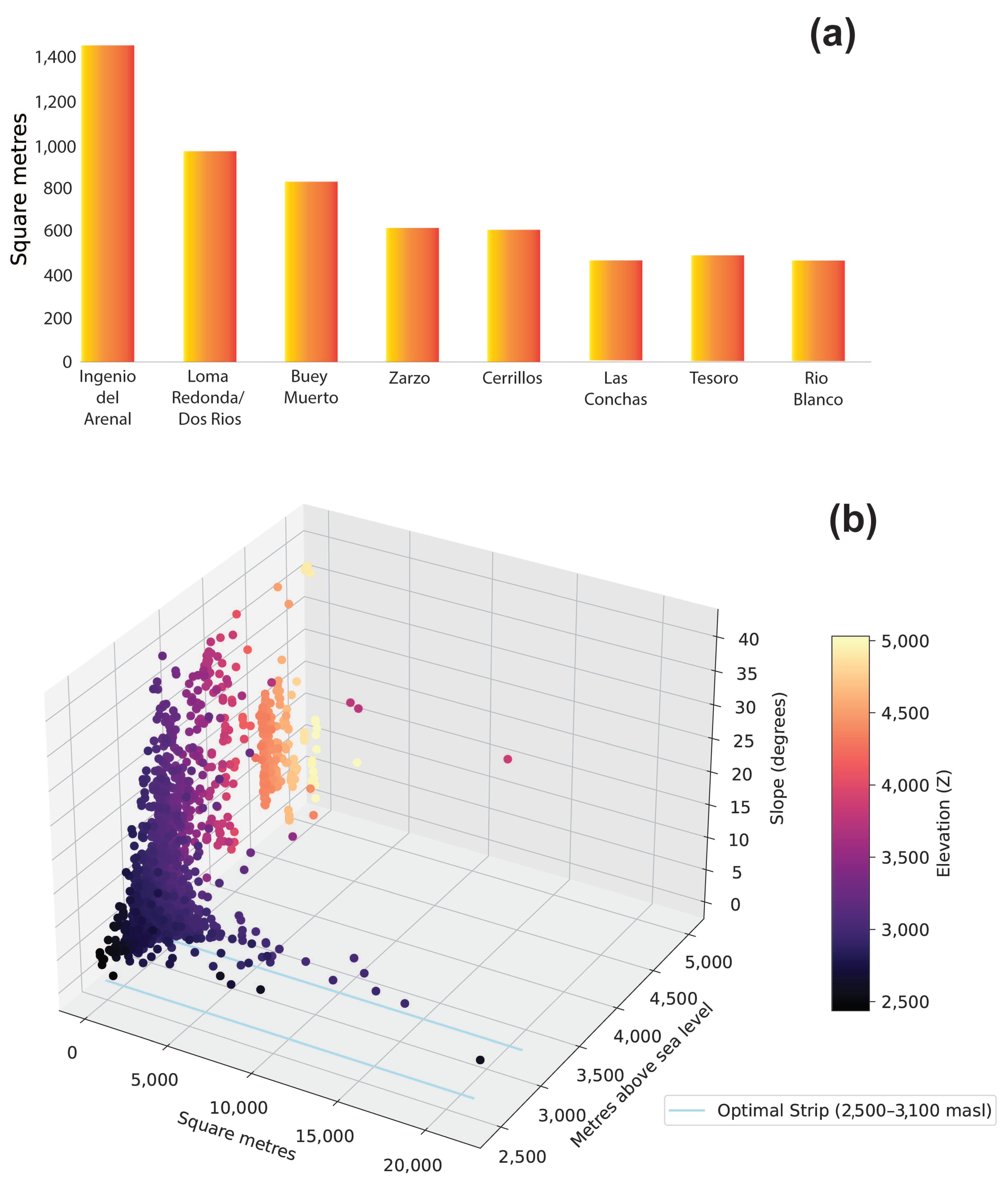
- Altitude-related distribution of aggregated built areas
- (c)
- Multi-directional connectivity
- (1)
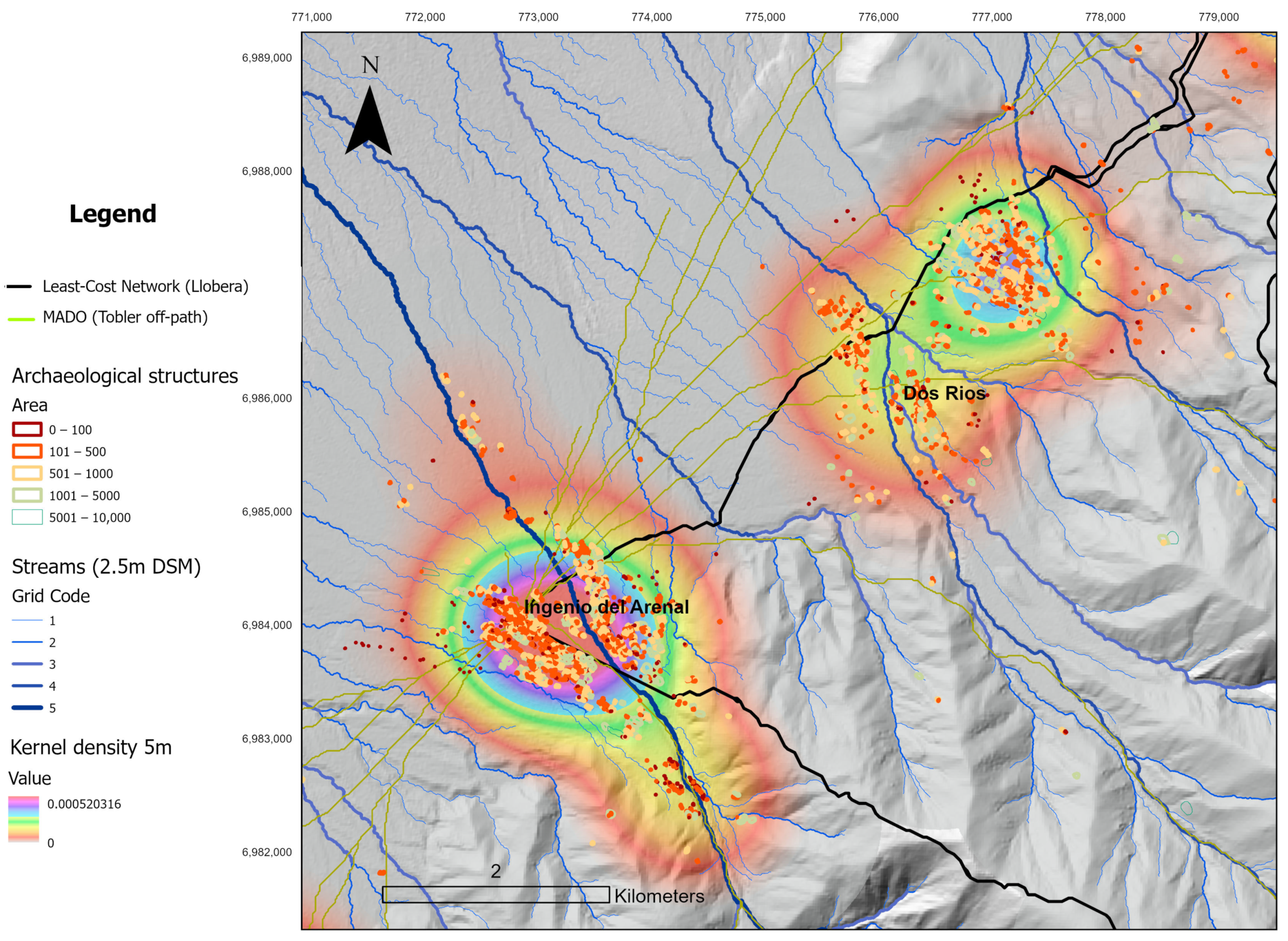
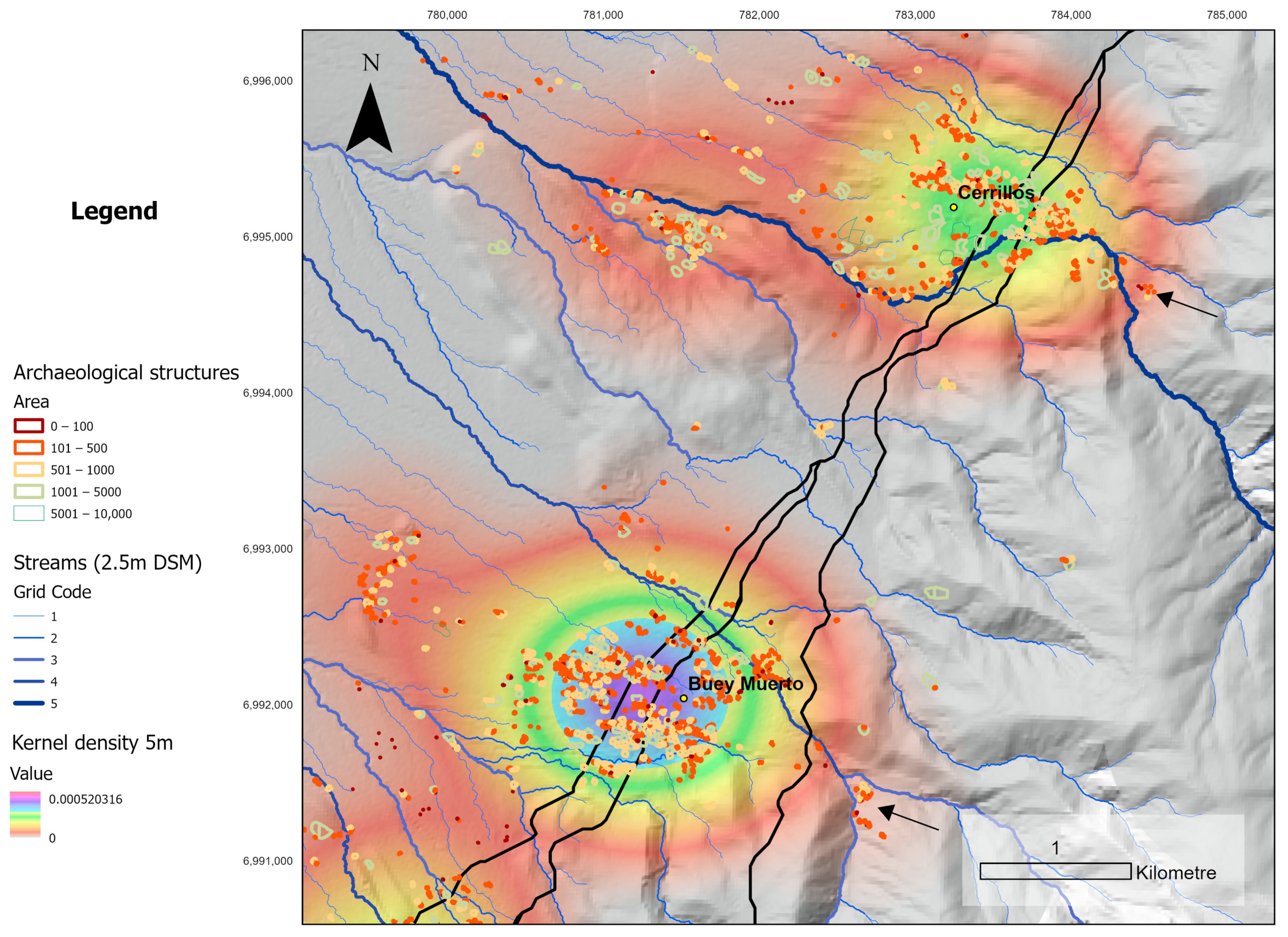
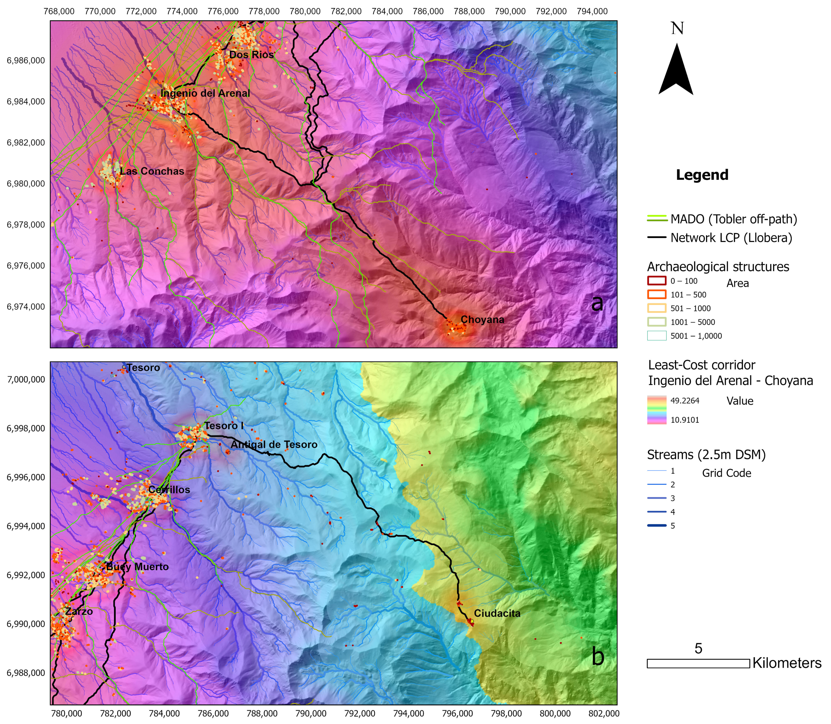
- N-S axis connectivity linking the alluvial fans at the base of the Aconquija Mountains is by far the dominant trend. This is consistently demonstrated by both Least-Cost network analysis and MADO, which have generated the largest number of paths within this sector (Figure 10). Most notably, the paths are skirting the altitudinal line at the highest point of the alluvial fans, where rivers are easier to cross. This outcome is unsurprising given the dominant presence of settlement within that sector, and that the trend has been retained by modern vehicle-based connectivity in western Aconquija. In recent historical times, there was a vehicle-accessible road skirting this altitude line, which, today, is only usable on foot or horseback. The annual festivity of San Roque sees pilgrims walking from Río Blanco to San José in the Santa María valley along one of the N-S axis roads skirting the western flank of the Sierra [60].
- (2)
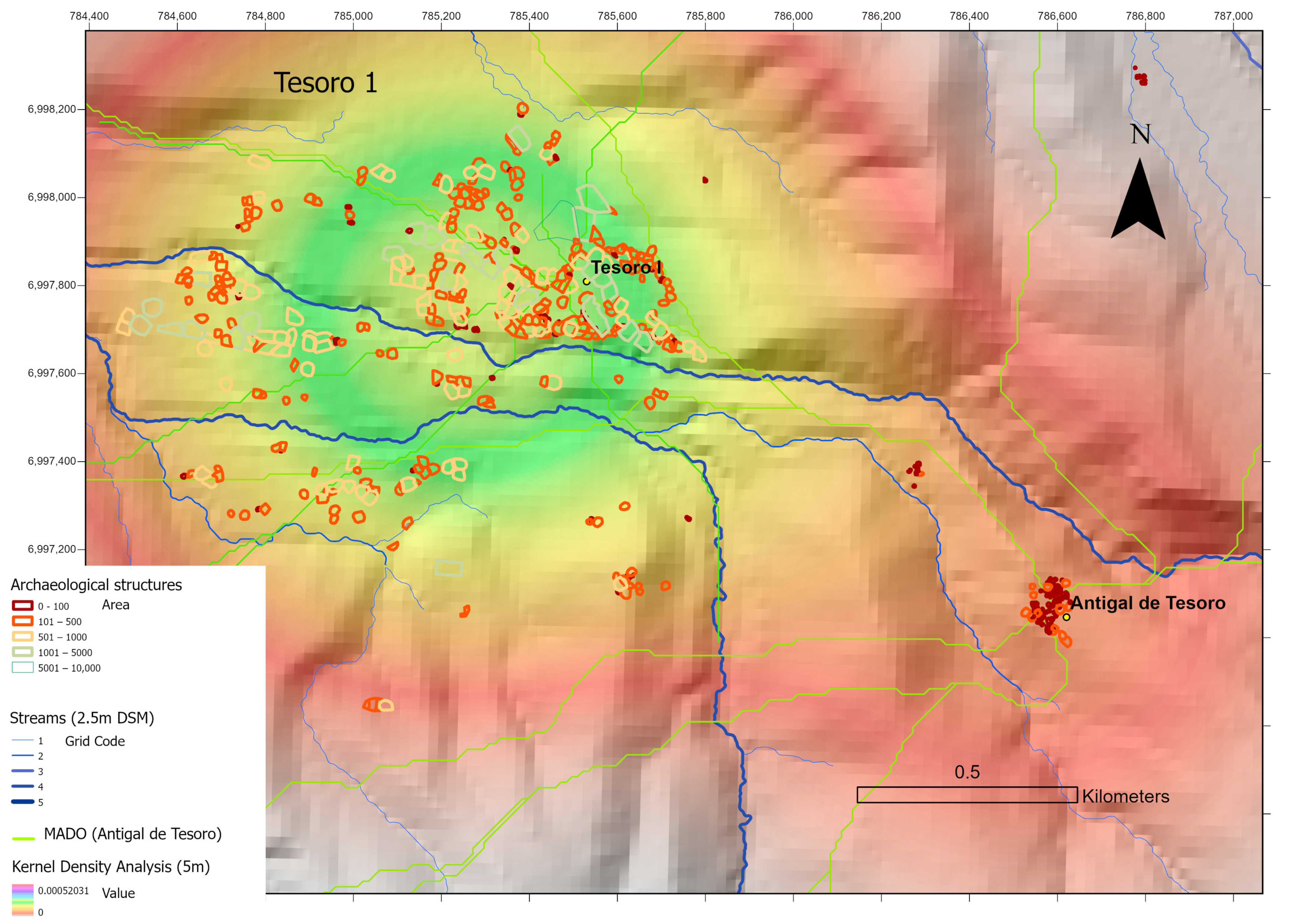
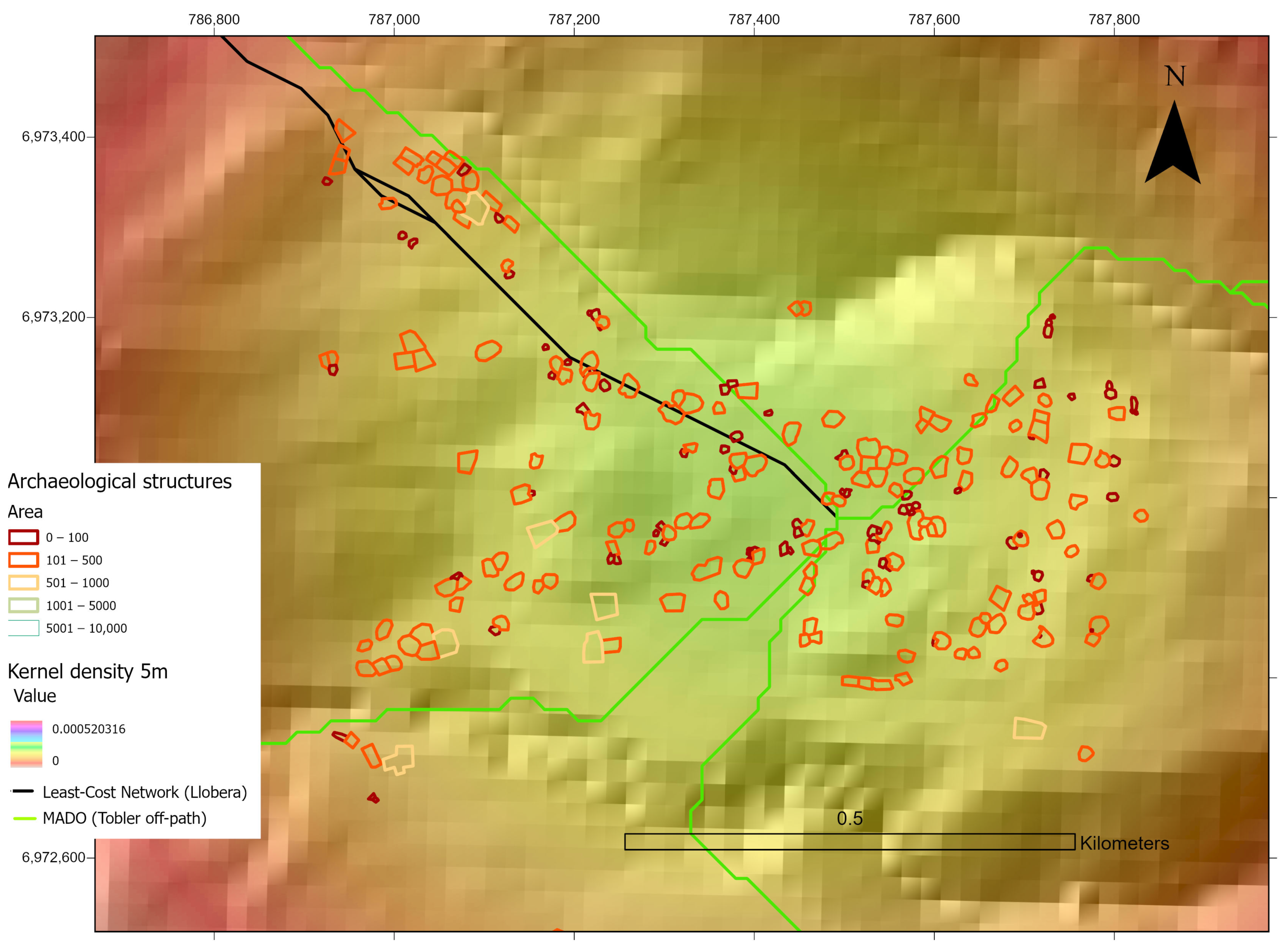
- E-W axis connectivity optimal routes have been flagged up consistently by MADO analysis for main aggregated sites (Figure 10). Given that Least-Cost calculations will identify routes or corridors in any scenario where both the start and the end point of the journeys are specified, MADO is a better method to explore routes’ potential, considering any optimal scenario around a central point. Accordingly, a range of optimal routes linking uplands with lower altitudes has been highlighted by this method, including in the Tesoro ravine, where a main optimal route could connect the early Formative Period site Antigal de Tesoro with both the main cores of aggregation within the larger settlement Tesoro I, and with peripheral aggregations borderline to the upper limit of the optimal zone (Figure 8). Further on, this site could also connect naturally with other main site agglomerations on the western flank of the Sierra, with roads skirting the upper sections of the alluvial fans (see above) and descending through the middle section of the terrace where Tesoro 1 is located, which offers flatter and higher ground relative to the riverbed (Figure 10b). Some MADO lines also connect Antigal de Tesoro with the higher edges of the alluvial fan above the ‘optimal strip’ where the larger site is located, suggesting potential complementary productive uses that must be further investigated. MADO analysis in this ravine also shows several opportunities for optimal movement eastwards across the mountains, including—but not limited to—the well-known crossing point of Abra del Toro [17,61] (4400 m asl, the lowest crossing point in the Sierra) and the path that leads to La Ciudacita (Figure 10b). The latter was further visualised via LCP and corridor analysis to provide a sensible image of an alternative movement strategy. The mobility lines and statistical accumulation as corridors coincide with well-known roads and crossing points of the Sierra still in use [17], giving further confidence in the outcomes of this analysis.
5. Conclusions
Author Contributions
Funding
Data Availability Statement
Acknowledgments
Conflicts of Interest
Correction Statement
References
- Aschero, C.A. Iconos, Huancas y Complejidad En La Puna Sur Argentina. In Producción y Circulación Prehispánicas de Bienes en el Sur Andino; Nielsen, A.E., Rivolta, M.C., Seldes, V., Vázquez, M.M., Mercolli, P.H., Eds.; Editorial Brujas: Córdoba, Argentina, 2007; Volume 1, pp. 135–166. [Google Scholar]
- Browman, D.L. Trade Patterns in the Central Highlands of Peru in the First Millennium B.C. World Archaeol. 1975, 6, 322–329. [Google Scholar] [CrossRef]
- Murra, J.V. Formaciones Económicas y Políticas En El Mundo Andino; Instituto de Estudios Peruanos: Lima, Peru, 1975. [Google Scholar]
- Núñez, L.; Dillehay, T.D. Movilidad Giratoria, Armonía Social y Desarrollo En Los Andes Meridionales: Patrones de Tráfico e Interacción Económica; Universidad del Norte, Facultad de Ciencias Sociales, Dirección General de Investigaciones Científicas y Tecnológicas, Departamento de Arqueología: Antofagasta, Chile, 1978. [Google Scholar]
- González Bonorino, F. Descripción Geológica de La Hoja 12e “Aconquija”, Provincias de Catamarca y Tucumán; Minería: Buenos Aires, Argentina, 1951. [Google Scholar]
- González, A. Dinámica Cultural Del Noroeste Argentino. Antiquitas 1979, 1, 28–29. [Google Scholar]
- Pérez Gollán, J.A. El Proceso de Integración En El Valle de Ambato: Complejidad Social y Sistemas Simbólicos. Rumiticama 1994, 1, 33–41. [Google Scholar]
- Raffino, R. Poblaciones Indígenas En Argentina. Urbanismo y Proceso Social Precolombino; Tipográfica Editora: Buenos Aires, Argentina, 1991. [Google Scholar]
- Scattolin, M.C. De Las Comunidades Aldeanas a Los Curacazgos En El Noroeste Argentino. Bol. Arqueol. PUCP 2006, 10, 357–398. [Google Scholar] [CrossRef]
- Scattolin, M.C. Formativo: El Nombre y La Cosa. In Crónicas Materiales Precolombinas. Arqueología de los Primeros Poblados del Noreoeste Argentino; Korstanje, M.A., Lazzari, M., Basile, M.L., Bugliani, M.F., Lema, V., Pereyra Domingorena, L., Quesada, M., Eds.; Sociedad Argentina de Antropología: Buenos Aires, Argentina, 2015; pp. 34–48. [Google Scholar]
- Scattolin, M.C. Un Examen Del Espacio Residencial y Productivo En El Aconquija. Rev. Shincal 2007, 7, 135–149. [Google Scholar]
- Scattolin, M.C. La Organización Del Hábitat Precalchaquí (500 Ac–1000 Dc). In El Hábitat Prehispánico: Arqueología de la Arquitectura y de la Construcción del Espacio Organizado; Albeck, M.A., Scattolin, M.C., Korstanje, M.A., Eds.; Edi UNJu: San Salvador de Jujuy, Argentina, 2010; pp. 13–51. [Google Scholar]
- Tarragó, M.N. El Formativo y El Surgimiento de La Complejidad Social En El Noroeste Argentino. In Formativo Sudamericano, Una Reevaluación; Ledergerber Crespo, P., Ed.; Abya-Yala: Quito, Ecuador, 1999; pp. 302–313. [Google Scholar]
- Ataliva, V.H.; Martel, A.R.; Somonte, C.; López Campeny, S.M.L. Notas Marginales Desde El Sitio Incaico Nevados Del Aconquija (Tucumán, Argentina). Andes 2010, 21, 161–186. [Google Scholar]
- Hyslop, J.; Schobinger, J. Las Ruinas Incaicas de Los Nevados Del Aconquija (Tucumán, Argentina). Informe Preliminar. Comechingonia 1991, 9, 17–30. [Google Scholar]
- Scattolin, M.C.; Williams, V.I. Actividades Minero-Metalúrgicas Prehispánicas En El Noroeste Argentino. Nuevas Evidencias y Su Significación. Bull. Inst. Fr. d’Etudes Andines 1992, 21, 59–87. [Google Scholar] [CrossRef]
- Scattolin, M.C.; Korstanje, M.A. Tránsito y Frontera En Los Nevados Del Aconquija. Arqueología 1994, 4, 165–197. [Google Scholar]
- Lynch, J.; Parcero-Oubiña, C. Under the Eye of the Apu. Paths and Mountains in the Inka Settlement of the Hualfín and Quimivil Valleys, NW Argentina. J. Archaeol. Sci. Rep. 2017, 16, 44–56. [Google Scholar] [CrossRef]
- Scattolin, M.C.; Albeck, M.E. El Asentamiento Humano En La Falda Occidental Del Aconquija (Catamarca, Argentina). Shincal 1994, 4, 35–65. [Google Scholar]
- Izeta, A. Zooarqueología Del Sur de Los Valles Calchaquíes. In Estudio de Conjuntos Faunísticos Del Período Formativo; Universidad Nacional de La Plata: La Plata, Argentina, 2004. [Google Scholar]
- Bugliani, M.F. Consumo y Representación En El Formativo Del Sur de Los Valles Calchaquíes; Universidad Nacional de La Plata: La Plata, Argentina, 2006. [Google Scholar]
- Lazzari, M. Stones to Build a World: Circulation and Value of Materials in Pre-Columbian Northwestern Argentina. Camb. Archaeol. J. 2016, 26, 1–22. [Google Scholar] [CrossRef]
- Pereyra Domingorena, L. Manufacturas Alfareras de Las Sociedades Aldeanas Del Primer Milenio d.C. al Sur de Los Valles Calchaquíes; Universidad de Buenos Aires: Buenos Aires, Argentina, 2011. [Google Scholar]
- Lazzari, M.; Domingorena, L.P.; Scattolin, M.C.; Cecil, L.; Glascock, M.D.; Speakman, R.J. Ancient Social Landscapes of Northwestern Argentina: Preliminary Results of an Integrated Approach to Obsidian and Ceramic Provenance. J. Archaeol. Sci. 2009, 36, 1955–1964. [Google Scholar] [CrossRef]
- Lazzari, M.; Pereyra Domingorena, L. Re-Visitando Ingenio Arenal-Faldas Del Cerro (Catamarca, Argentina): Relevamiento Planimétrico y Nuevos Sondeos. In Proceedings of the Actas del 15 Congreso Nacional de Arqueologia Argentina, Río Cuarto; Austral, A., Tamagini, M., Eds.; Universidad Nacional de Río Cuarto: Río Cuarto, Argentina, 2008; pp. 761–764. [Google Scholar]
- Oltean, I.; Lazzari, M.; Lungescu, D. Andean Heights: A Preliminary Exploration of Pre-Columbian Settlement and Land Use in NW Argentina through Remote Sensing. In Proceedings of the International Aerial Archaeology Group Conference, Constanta, Romania, 12–14 September 2019. [Google Scholar]
- Scattolin, M.C. Dos Asentamientos Formativos al Pie Del Aconquija. El Sitio Loma Alta (Catamarca, Argentina). Gac. Arqueol. Andina 1990, 5, 85–100. [Google Scholar]
- Scattolin, M.C.; Lazzari, M. Informe de Actividades y Observaciones En La Falda Occidental Del Aconquija. Palimpsesto 1993, 3, 150–154. [Google Scholar]
- Ingold, T. The Temporality of the Landscape. World Archaeol. 1993, 25, 152–174. [Google Scholar] [CrossRef]
- Lazzari, M.; Pereyra Domingorena, L.; Stoner, W.; Scattolin, M.C.; Korstanje, M.A.; Glascock, M.D. Compositional Data Supports Decentralized Model of Production and Circulation of Artifacts in the Pre-Columbian South-Central Andes. Proc. Natl. Acad. Sci. USA 2017, 114, E3917–E3926. [Google Scholar] [CrossRef]
- Gosden, C. Prehistoric Social Landscapes of the Arawe Islands, West New Britain Province, Papua New Guinea. Archaeol. Ocean. 1989, 24, 45–58. [Google Scholar] [CrossRef]
- Lazzari, M.; Korstanje, A. The Past as a Lived Space: Heritage Places, Re-Emergent Aesthetics, and Hopeful Practices in NW Argentina. J. Soc. Archaeol. 2013, 13, 394–419. [Google Scholar] [CrossRef]
- Lazzari, M. Things and the Production of Social Space. In An Archaeological Study of Value and Circulation in NW Argentina, First Millennium AD; Columbia University: New York, NY, USA, 2006. [Google Scholar]
- Márquez Miranda, F.; Cigliano, E. Problemas Arqueológicos En La Zona de Ingenio Del Arenal (Provincia de Catamarca, República Argentina). Rev. Museo Plata Secc. Antropol. 1961, 5, 123–169. [Google Scholar]
- Scattolin, M.C. Las Excavaciones de Alberto Rex González En Buey Muerto (Catamarca, Argentina); Un Sumario y Estudios Complementarios: Catamarca, Argentina, 2024. [Google Scholar]
- Weiser, V. Diarios y Libretas de Campo Inéditas de Las Expediciones; Benjamín Muniz Barreto: La Plata, Argentina, 1922. [Google Scholar]
- Pochettino, M.L.; Scattolin, M.C. Identificación y Significado de Frutos y Semillas Carbonizados de Sitios Arqueológicos Formativos de La Ladera Occidental Del Aconquija (Prov. de Catamarca, Argentina). Rev. Museo Plata Antropol. 1991, 70, 169–181. [Google Scholar]
- Berberián, E.E.; Nielsen, A.E. Sistemas de Asentamiento Prehispánico En La Etapa Formativa Del Valle de Tafí (Pcia. De Tucumán-Rep. Arg.). In Sistemas de Asentamiento Prehispánicos en el Valle de Tafí; Berberián, E., Ed.; Editorial Comechingonia: Córdoba, Spain, 1988; pp. 21–51. [Google Scholar]
- Wernke, S.A.; Van Valkenburgh, P.; Zimmer-Dauphinee, J.; Whitlock, B.; Spence Morrow, G.; Smith, R.; Smit, D.; Roque Ortega, G.; Ricci Jara, K.; Plekhov, D.; et al. Large-Scale, Collaborative Imagery Survey in Archaeology: The Geospatial Platform for Andean Culture, History and Archaeology (GeoPACHA). Antiquity 2024, 98, 155–171. [Google Scholar] [CrossRef]
- Saintenoy, T.; Ajata, R.; Romero, Á.; Sepúlveda, M. Arqueología Del Territorio Aldeano Prehispánico Tardío En Los Altos de Arica: Aportes de La Fotointerpretación Satelital Para El Estudio Regional de La Cuenca Alta de Azapa. Estud. Atacameños 2017, 1, 85–110. [Google Scholar] [CrossRef][Green Version]
- Oyaneder, A. No Masters, No Crops: A Long-Term Archaeological and Satellite Imagery Study of Forager Societies in the Camarones Basin (Northern Chile), ca 3700—400 BP. Ph.D. Thesis, University of Exeter, Exeter, UK, 2022. [Google Scholar]
- Leberl, F.; Walcher, W.; Kröpfl, M. The Microsoft Global Ortho Program. ISPRS Ann. Photogramm. Remote Sens. Spat. Inf. Sci. 2012, 1–4, 53–58. [Google Scholar]
- Agapiou, A.; Alexakis, D.D.; Hadjimitsis, D.G. Spectral Sensitivity of ALOS, ASTER, IKONOS, LANDSAT and SPOT Satellite Imagery Intended for the Detection of Archaeological Crop Marks. Int. J. Digit. Earth 2014, 7, 351–372. [Google Scholar] [CrossRef]
- Fuldain González, J.; Varón Hernández, F. NDVI Identification and Survey of a Roman Road in the Northern Spanish Province of Álava. Remote Sens. 2019, 11, 725. [Google Scholar] [CrossRef]
- Lasaponara, R.; Masini, N. Identification of Archaeological Buried Remains Based on the Normalized Difference Vegetation Index (NDVI) From Quickbird Satellite Data. IEEE Geosci. Remote Sens. Lett. 2006, 3, 325. [Google Scholar] [CrossRef]
- Verhoeven, G. The Reflection of Two Fields—Electromagnetic Radiation and Its Role in (Aerial) Imaging. AARG News 2017, 55, 13–18. [Google Scholar]
- Baret, F.; Guyot, G. Potentials and Limits of Vegetation Indices for LAI and APAR Assessment. Remote Sens. Environ. 1991, 35, 161–173. [Google Scholar] [CrossRef]
- Duncan, J.; Stow, D.; Franklin, J.; Hope, A. Assessing the Relationship between Spectral Vegetation Indices and Shrub Cover in the Jornada Basin, New Mexico. Int. J. Remote Sens. 1993, 14, 3395–3416. [Google Scholar] [CrossRef]
- Kauth, R.J.; Thomas, G.S. The Tasselled Cap—A Graphic Description of the Spectral-Temporal Development of Agriculturalcrops as Seen by LANDSAT. LARS Symp. 1976, 159, 41–51. [Google Scholar]
- Perry, C.R.; Lautenschlager, L.F. Functional Equivalence of Spectral Vegetation Indices. Remote Sens. Environ. 1984, 14, 169–182. [Google Scholar] [CrossRef]
- Qi, J.; Chehbouni, A.; Huete, A.R.; Kerr, Y.H.; Sorooshian, S. A Modified Soil Adjusted Vegetation Index. Remote Sens. Environ. 1994, 48, 119–126. [Google Scholar] [CrossRef]
- Silverman, B.W. Density Estimation for Statistics and Data Analysis; Chapman & Hall: London, UK, 1998; ISBN 9781315140919. [Google Scholar]
- Alberti, G. Movecost: An R Package for Calculating Accumulated Slope-Dependent Anisotropic Cost-Surfaces and Least-Cost Paths. SoftwareX 2019, 10, 100331. [Google Scholar] [CrossRef]
- Tobler, W. Three Presentations on Geographical Analysis and Modeling: Non-Isotropic Modeling Speculations on the Geometry of Geography Global Spatial Analysis; University of California: Santa Barbara, CA, USA, 1993. [Google Scholar]
- Llobera, M.; Sluckin, T.J. Zigzagging: Theoretical Insights on Climbing Strategies. J. Theor. Biol. 2007, 249, 206–217. [Google Scholar] [CrossRef]
- Oltean, I.A.; Fonte, J. GIS Analysis and Spatial Networking Patterns in Upland Ancient Warfare: The Roman Conquest of Dacia. Geosciences 2021, 11, 17. [Google Scholar] [CrossRef]
- Parcero-Oubiña, C.; Smart, C.; Fonte, J. Remote Sensing and GIS Modelling of Roman Roads in South West Britain. J. Comput. Appl. Archaeol. 2023, 6, 62–78. [Google Scholar] [CrossRef]
- Fábrega-Álvarez, P. Moving without Destination. A Theoretical, GIS-Based Determination of Routes (Optimal Accumulation Model of Movement from a given Origin). J. Theor. Biol. 2007, 249, 206–217. [Google Scholar]
- Llobera, M.; Fábrega-Álvarez, P.; Parcero-Oubiña, C. Order in Movement: A GIS Approach to Accessibility. J. Archaeol. Sci. 2011, 38, 843–851. [Google Scholar] [CrossRef]
- Cabrera, M. Así Es La Verdadera Fiesta de San Roque En Catamarca. Available online: https://www.linkedin.com/pulse/as%C3%AD-es-la-verdadera-fiesta-de-san-roque-en-catamarca-miguel-cabrera/ (accessed on 1 July 2024).
- Francisco, M. Tucumán. In Historia de la Minería Argentina; Lavandaio, E., Catalano, E., Eds.; SEGMAR: Buenos Aires, Argentina, 2004; Volume II, pp. 91–101. [Google Scholar]
- Tapia, A. Apuntes Sobre Glaciarismo Pleistoceno En Los Nevados Del Aconquija. Anales GAEA 1925, 4, 312–364. [Google Scholar]
- White-Nockleby, C.; Prieto, M.; Yager, K.; Meneses, R.I. Understanding Bofedales as Cultural Landscapes in the Central Andes. Wetlands 2021, 41, 102. [Google Scholar] [CrossRef]
- Arnold, Y.D. Cartografías de la Memoria: Hacia un Paradigma Més Dinámico y Viviente del Espacio; Cuadernos de la Facultad de Humanidades y Ciencias Sociales, UNJU: San Salvador de Jujuy, Argentina, 2009; Volume 36, pp. 203–244. [Google Scholar]
- Weismantel, M.J. Making Breakfast and Raising Babies: The Zumbagua Household as Constituted Process. In The Household Economy: Reconsidering the Domestic Mode of Production; Wilk, R.R., Ed.; Westview Press: Boulder, CO, USA, 1989; pp. 55–72. [Google Scholar]
- Brush, S.B. Mountain, Field, and Family: The Economy and Human Ecology of an Andean Valley; University of Pennsylvania Press: Philadelphia, PA, USA, 1977. [Google Scholar]
- Mayer, E. The Articulated Peasant: Household Economies in the Andes; Westview Press: Boulder, CO, USA, 2002. [Google Scholar]
- Delfino, D.D.; Espiro, E.E.; Díaz, R.A. Prácticas Sociales En El Pasado y El Presente de Laguna Blanca (Dpto Belén, Catamarca): Reflexiones En Torno Almodo de Visa Comunitario Agrocéntrico. In Crónicas Materiales Precolombinas. Arqueología de los Primeros Poblados del Noroeste Argentino; Korstanje, M.A., Lazzari, M., Basile, M., Bugliani, M.F., Lema, V., Pereyra Domingorena, L., Quesada, M., Eds.; Sociedad Argentina de Antropología: Buenos Aires, Argentina, 2015; pp. 386–426. [Google Scholar]
- Korstanje, M.A. Territorios Campesinos: Producción, Circulación y Consumo En Los Valles Altos. In Producción y Circulación Prehispánicas de Bienes en el Sur Andino; Nielsen, A.E., Rivolta, M.C., Seldes, V., Vázquez, M.M., Mercolli, P.H., Eds.; Editorial Brujas: Córdoba, Argentina, 2007; Volume 2, pp. 191–223. [Google Scholar]
- Fresno, J.V. “El Incentivo Mayor de Las Naciones.” Vestigios de una Explotación Minera Olvidada en el Tucumán Colonial (1759–1765); Universidad de Buenos Aires: Buenos Aires, Argentina, 2023. [Google Scholar]
- Rodríguez, L. Explotaciones Mineras Intermitentes y Promesas Permanentes de Riqueza. Descubrimientos, Redescubrimientos y Ordenamientos al Sur Del Valle Calchaquí, Fines Del Siglo XVII-Mediados Del XIX. Poblac. Soc. 2015, 22, 61–91. [Google Scholar]
- Lazzari, M.; Larsen, P.B.; Orlandi, F. Introduction—The Heritage and Decoloniality Nexus: Global Exchanges and Unresolved Questions in Sedimented Landscapes of Injustice. Am. Anthropol. 2024, 126, 311–316. [Google Scholar] [CrossRef]
- Tsing, A.L. Friction: An Ethnography of Global Connection; Princeton University Press: Princeton, NJ, USA, 2011. [Google Scholar]


Disclaimer/Publisher’s Note: The statements, opinions and data contained in all publications are solely those of the individual author(s) and contributor(s) and not of MDPI and/or the editor(s). MDPI and/or the editor(s) disclaim responsibility for any injury to people or property resulting from any ideas, methods, instructions or products referred to in the content. |
© 2024 by the authors. Licensee MDPI, Basel, Switzerland. This article is an open access article distributed under the terms and conditions of the Creative Commons Attribution (CC BY) license (https://creativecommons.org/licenses/by/4.0/).
Share and Cite
Lazzari, M.; Oltean, I.; Oyaneder Rodríguez, A.; Scattolin, M.C.; Pereyra Domingorena, L. Andean Landscape Legacies: Comprehensive Remote Sensing Mapping and GIS Analysis of Long-Term Settlement and Land Use for Sustainable Futures (NW Argentina). Remote Sens. 2024, 16, 3795. https://doi.org/10.3390/rs16203795
Lazzari M, Oltean I, Oyaneder Rodríguez A, Scattolin MC, Pereyra Domingorena L. Andean Landscape Legacies: Comprehensive Remote Sensing Mapping and GIS Analysis of Long-Term Settlement and Land Use for Sustainable Futures (NW Argentina). Remote Sensing. 2024; 16(20):3795. https://doi.org/10.3390/rs16203795
Chicago/Turabian StyleLazzari, Marisa, Ioana Oltean, Adrián Oyaneder Rodríguez, María Cristina Scattolin, and Lucas Pereyra Domingorena. 2024. "Andean Landscape Legacies: Comprehensive Remote Sensing Mapping and GIS Analysis of Long-Term Settlement and Land Use for Sustainable Futures (NW Argentina)" Remote Sensing 16, no. 20: 3795. https://doi.org/10.3390/rs16203795
APA StyleLazzari, M., Oltean, I., Oyaneder Rodríguez, A., Scattolin, M. C., & Pereyra Domingorena, L. (2024). Andean Landscape Legacies: Comprehensive Remote Sensing Mapping and GIS Analysis of Long-Term Settlement and Land Use for Sustainable Futures (NW Argentina). Remote Sensing, 16(20), 3795. https://doi.org/10.3390/rs16203795


