Abstract
Sea ice monitoring is key to analyzing the Earth’s climate system. Long-term sea ice extent (SIE) has been continuously monitored using various spaceborne passive microwave radiometers (PMRs) since November 1978. As the lifetime of a satellite is usually approximately 5 years, bias caused by differences in PMRs should be eliminated to obtain objective SIE trends. Most sea ice products have been analyzed for long-term trends with a bias adjustment based on the coarse resolution special sensor microwave imager (SSM/I) in operation for the longest period. However, since 2002, Japanese microwave radiometers of the Advanced Microwave Scanning Radiometer (AMSR) series, which have the highest spatial resolution in PMR, have been available. In this study, we developed standardization techniques for processing SIE including calibration of the brightness temperature (TB), tuning the sea ice concentration (SIC) algorithm, and adjusting the SIC threshold to retrieve a consistent SIE trend based on the AMSR for the Earth Observing System (AMSR-E, one of the AMSR that operated from May 2002 to October 2011). Analysis results showed that the root-mean-square error between AMSR-E SICs and those of moderate resolution imaging spectroradiometer (MODIS) was 15%. In this study, SIE was defined as the sum of the areas where the AMSR-E SIC was >15%. When retrieving SIE, we adjusted the SIC threshold for each PMR to be consistent with the SIE calculated based on the 15% SIC threshold for AMSR-E. We then calculated a time-series of the SIE trends over approximately 45 years using the adjusted SIE data. Therefore, we revealed the dramatic decrease in global sea ice extent since 1978. This technique enables retrieval of more accurate long-term sea ice trends for more than half a century in the future.
1. Introduction
Sea ice cover needs to be continually monitored to track Earth’s climate changes. Satellite-borne passive microwave radiometers (PMRs) are used to record modern daily and global sea ice. The NASA Nimbus-7 scanning multichannel microwave radiometer (SMMR) monitored sea ice from November 1978 to July 1987. From July 1987 to the present, the series of the U.S. Defense Meteorological Satellite Program (DMSP) special sensor microwave imager (SSM/I) continued monitoring sea ice. Furthermore, the SSM/I sensor was succeeded with a mirror instrument known as the DMSP special sensor microwave imager/sounder (SSMIS). Combined SMMR, SSM/I, and SSMIS data have typically been used to derive long-term sea ice trends since November 1978. The long-term sea ice datasets from the SMMR and SSM/I series are available through the NASA Team (NT1) [1], Bootstrap Version 2 [2], and European Meteorological Satellite Program (EUMETSAT) Ocean and Sea Ice Satellite Application Facility (OSI-SAF Version 2) [3].
The Advanced Microwave Scanning Radiometer for the Earth Observing System (AMSR-E), a Japanese spaceborne passive microwave sensor, was launched aboard the National Aeronautics and Space Administration (NASA) Aqua satellite in May 2002 and operated until October 2011. The Advanced Microwave Scanning Radiometer 2 (AMSR2), aboard the Global Change Observation Mission for Water (GCOM-W), was launched in May 2012 as a successor of AMSR-E. The capabilities of the AMSR series dataset exceed those of the SMMR, SSM/I, and SSMIS due to its larger antenna (yielding higher spatial resolution). A higher spatial resolution results in a more accurate ice edge point compared to those obtained with past sensors; therefore, sea ice cover can be monitored more accurately. The advent of AMSR-E data in mid-2002 considerably improved the capability of sea ice monitoring [4].
However, combining data from various PMRs with different orbits and specifications should be performed carefully because mismatches in the locations of the ice edges can occur as a result of different resolutions, antenna patterns (such as side lobes), observation times, center frequencies, incident angles, and calibrations [4,5]. Therefore, AMSR series datasets cannot be easily used to examine climate variability due to unknown biases in combining SMMR and SSM/I series [6].
While there are no plans for further missions using the SSM/I and SSMIS series sensors (except for the MicroWave Imager (MWI) on the Weather System Follow-on (WSF) platform launched in April 2024 by the US Defense Department), AMSR-E and AMSR2 have a total observation period of over 20 years. AMSR2 observations will likely be succeeded by future sensors. Unless we combine the SMMR, SSM/I series, and AMSR series, we cannot monitor sea ice variability over the past half century. In this study, we aimed to combine the AMSR series with historical PMRs for climate change study with improved quality.
To combine the AMSR series data with those of other PMRs, we (1) generated consistent brightness temperatures (TBs) at 18 and 36 GHz vertical polarization (18 and 36 V), and 36 GHz horizontal polarization (36 H) channels among the PMRs by intersensor calibration; (2) retrieved SIC by the same algorithm (AMSR-E bootstrap algorithm (ABA)); and (3) estimated SIE and its trends by adjusting the SIC threshold value for each sensor.
2. Materials and Methods
2.1. Spaceborne PMR Data
Our sea ice trends were calculated from the SMMR, F08&F10&F13 SSM/I, AMSR-E, WindSat, and AMSR2 data. F16, F17, and F18 SSMIS sensors have been used in sea ice time series, but we did not use SSMIS in this study. Table 1 lists the characteristics of each sensor. The SMMR data from November 1978 to July 1987 were obtained, as well as SSM/I series data from July 1987 to June 2002. We used SSM/I series data corrected for TB differences among the SSM/I series by remote sensing systems [7,8,9].

Table 1.
Major characteristics of spaceborne microwave radiometers.
High-resolution AMSR-E data were used as baseline data for this sea ice dataset. AMSR-E data were provided from June 2002 to October 2011. AMSR-E has a higher spatial resolution at all frequencies, wider spectral range, and wider swath width than that of SSM/I.
To maintain sea ice data with a high spatial resolution, WindSat data, rather than SSM/I or SSMIS data, were used to fill the observation gap between the AMSR-E and AMSR2, from October 2011 to July 2012 [10]. WindSat has an 18.7 GHz channel, further from the water vapor channel (approximately 22 GHz) than the 19.35 GHz of the SSM/I channel. Therefore, WindSat SIC data are less influenced by water vapor than SSM/I. From July 2012 to the present, the AMSR2 dataset was used. Level 1B data, which had an original resolution for each TB channel, were used for SMMR, SSM/I, and AMSR-E. AMSR2 resampled Level 1 product (L1R) data with a channel resolution of 23.8 GHz (15 × 26 km) were used instead of Level 1B. For WindSat data, the Level 1 Sensor Data Record (SDR) with a resolution of 18 GHz was used.
The data acquisition of the 21.0 GHz channel of the SMMR stopped in 1983 [11]. The SMMR 6.6 GHz vertical-polarization channel was unstable during the operation period. The SSM/I did not have a 6 GHz channel. The WindSat 6.8 GHz vertical-polarization channel was not included in the WindSat Level 1 Sensor Data Record (SDR) used in this study [12]. Therefore, the 21.0 GHz channel for SMMR and the 6 GHz for SMMR, SSM/I, and WindSat were not used in this study.
2.2. Validation and Comparison Data
We used the sea ice/cloud flag (MYD29) produced by the moderate resolution imaging spectroradiometer (MODIS) aboard the Aqua satellite [13,14,15] to validate the SIC of the AMSR-E. We selected clear-sky pixels (80% cloud-free) and derived the SIC from MODIS as a fraction of the MYD29 sea ice flag within the AMSR-E 36 GHz footprint size (14.4 × 8.2 km).
The ice chart developed by the National Ice Center (NIC) [16,17] was used to remove false estimates of the MODIS sea ice flag. The NIC ice charts, which show SIC ranges (for example 10–30%), were derived using optical or synthetic aperture radar data (including ENVISAT, AVHRR, RADARSAT, QUIKSCAT, OLS, and MODIS). The ice edges in the ice charts are more accurate and detailed than those derived from PMRs because they are often manually obtained from higher-resolution satellite data.
Our datasets were compared with three types of SIE derived for the Climate Data Record (CDR): the NASA team (G02135) [18], Bootstrap (NSIDC-0192) [19], and OSI-420 [20] SIE, as listed in Table 2. These SIEs were all derived from the SMMR and SSM/I series data. The SIC products of NSIDC-0051 [21], NSIDC-0079 [2], and OSI-450-a [22] were used for retrieving SIE of G02135, NSIDC-0192, and OSI-420, respectively.

Table 2.
Products used in validation and comparison.
2.3. Methodology for Intersensor Calibration
PMRs do not observe the Earth at the same frequency channel set. Therefore, the TB required calibration, and the SIC algorithm needed tuning. To retrieve long-term SIE trends, the TB conversion coefficients were determined based on AMSR-E, which has high observation accuracy compared to those of historical PMRs. To retrieve objective SIE trends, the same SIC algorithm for all sensors must be used. We used the ABA for retrieving the SIC. The ABA uses the 36 V 18 V and 36 H 36 V channel sets. Therefore, the 18 V, 36 V, and 36 H TBs of the SMMR, SSM/I, WindSat, and AMSR2 were adjusted to maintain consistency with those of the AMSR-E at higher SICs (≥80%). This advantage was that we could use the same coefficients for the 100% SIC lines (Figure 1, Line A–I) and 100% SIC points (Figure 1, Point A) in the ABA [4]. To adjust the TB of each sensor to that of AMSR-E, we calculated the linear regression line between AMSR-E and SSM/I (WindSat) during the overlapping period and converted the original SSM/I (WindSat) TBs to the AMSR-E-equivalent TB using Equation (1) [4]. Subsequently, SMMR (AMSR2) was adjusted using the AMSR-E-equivalent SSM/I (WindSat).
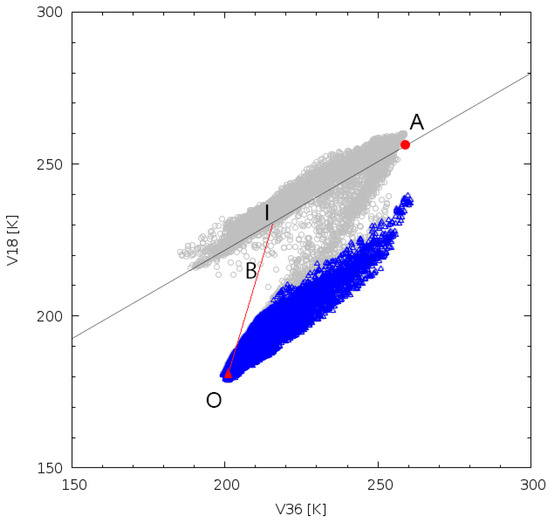
Figure 1.
Schematic of the AMSR-E bootstrap algorithm. Gray circles represent sea ice areas and blue triangles correspond to open water areas or <10% sea ice concentration (SIC). The thin solid line is the SIC 100% line. The red triangle (O) is the open water tie-point (SIC 0% point), and the red circle is the SIC 100% point (point A). Point B is one of the observation points. Point I is the intersection of the SIC 100% line and the extension of the OB line. The SIC at point B is the ratio of OB to OI.
More specifically, the following conversion was applied:
where a and b are the fitting parameters corresponding to the offset and slope of the regression line, respectively. For this method, land uncontaminated TB (ocean TB) must be used. Therefore, we used only TB, which is far from land as mentioned below (Section 2.4.2). Consequently, we obtained the conversion coefficients for the PMRs data during the entire year.
TB (AMSR-E-equivalent) = a + b × TB (original),
2.4. Methodology for SIC Algorithm (ABA) Tuning and Retrieval
2.4.1. Open Water Tie-Point Tuning
Open water tie-point was defined as the reference TB of SIC equal to 0% (hereafter referred to as “SIC = 0%”) (Figure 1, Point O). After calibrating the PMR TB with a high SIC (≥80%), the coefficient with a low SIC became unmatched in the ABA. Therefore, we tuned the open water tie-point. TBs of the open water tie-point are typically observed over the ocean under calm surfaces and are generally lower than those observed under strong winds or severe weather conditions [23]. Therefore, the open water tie-point value remained low throughout one year owing to the calm weather conditions.
Open water tie-points were calculated using the points where the other sensor observed SIC = 0% on the same day during the overlapping period. We computed the TB histogram of SIC = 0% for a sample day every month for one year.
As a result, more stable points throughout one year were one-third height below the peak of the TB histogram of SIC = 0%. Consequently, we defined the open water tie-point as the average TB at a one-third height below the peak of the TB histogram of SIC = 0% for one year during the sensor-to-sensor overlapping period. Open water tie-points of 36 V, 18 V, and 36 H were separately estimated using this procedure. Subsequently, open water tie-points were calculated separately for the Northern and Southern Hemispheres.
Tuning of the open water tie-point was the most important factor in retrieving continuous SIE. Using the tuned open water tie-point, we confirmed that the intersensor bias of the SIE is almost constant throughout the year, which aids in deriving continuous sea ice trends. However, the unknown biases in SIE between PMRs could not be completely removed by open water tie-point tuning alone.
2.4.2. Open Ocean Mask Line Tuning
As stated above, we adjusted the TB of each sensor to that of AMSR-E at higher SICs (≥80%). In the lower SIC area, the TBs of the PMRs during the overlapping period did not match. Therefore, the open ocean mask line (weather filter) in the ABA needed adjustment. The ABA misclassifies water vapor, rain, and strong wind areas over the open ocean as sea ice; thus, the open ocean area must be differentiated from the ice cover [24]. We used “open ocean mask line” instead of “weather filter” in the ABA to avoid the misunderstanding caused by the removal of weather effects. The AMSR-E open ocean mask line uses 36 and 6 GHz vertical polarization (36 V 6 V) and 23 and 18 GHz vertical polarization (23 V 18 V).
The same method as that for AMSR-E was applied to AMSR2, but not to other PMRs (SMMR, SSM/I, and WindSat) due to limited channel availability, as mentioned in Section 2.1. To overcome these limitations, the analysis of SMMR differentiated specific weather conditions using 36 and 18 GHz vertical polarization (36 V 18 V) channel sets. For SSM/I and WindSat, channel sets of 36 and 18 GHz vertical polarization (36 V 18 V) and 23 and 18 GHz vertical polarization (23 V 18 V) were used instead [24].
For example, Figure 2 shows the open ocean mask lines for SSM/I. The 36 V 18 V open ocean mask line (Figure 2a, black line) was obtained by linearly fitting the TB data corresponding to SIC < 10% (hereafter referred to as “SIC < 10%”) and adding two standard deviation offsets, which were observed by the other sensor (AMSR-E for this case) on the same day. The 23 V 18 V open ocean mask line was obtained by linearly fitting the residuals of the TB data at SIC < 10% after removal by the 36 V 18 V channel set (Figure 2b, black line) and adding two standard deviation offsets. An additional threshold for the difference between 23 and 18 V (23 V–18 V) was calculated using the residual TBs after removal by the 36 V 18 V channel set (Figure 2b, red line). The points under the open ocean mask lines were then estimated as SIC < 10%. To minimize the effects of the coastal area on the TB, we used ocean TBs, which were far from three to four pixels with respect to the original coast.
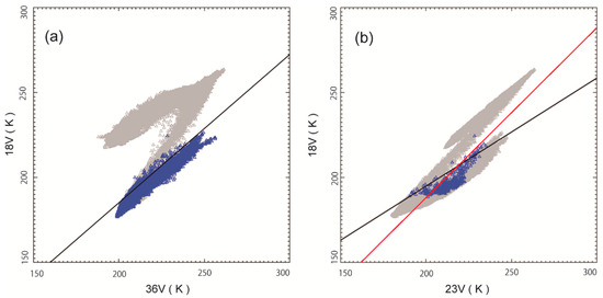
Figure 2.
Open Ocean mask lines for SSM/I. Blue points correspond to ice-free or less than 10% SIC and those in gray correspond to SIC 0–100% data (all valid data). Scatter plots for (a) 36 V versus 18 V (36 V 18 V). The black line in (a) is the open ocean mask line for 36 V 18 V. Scatter plots for (b) 23 V against 18 V (black line) and difference in thresholds of 23 V and 18 V (red line). The black line for 23 V 18 V in (b) is the regression line of the residual blue points over the 36 V 18 V line. The red line at 23 V 18 V has a slope of 1.0.
Using this procedure, the open ocean mask line was calculated as a sample of one day/month for one year during the overlapping period. After that, throughout one year, we defined one set of lines in the Southern Hemisphere and two sets of lines for summer and winter in the Northern Hemisphere. We defined one set of lines to be applied to the entire year in both hemispheres only for SMMR because the overlapping period between the SMMR and F08 SSM/I was only six weeks, covering the Northern Hemisphere summer and Southern Hemisphere winter seasons.
2.4.3. SIC Retrieval
Subsequently, the ABA was applied to the SMMR, SSM/I, AMSR-E, WindSat, and AMSR2 data using the tuned open ocean tie-point and the open ocean mask line to generate the SIC dataset with enhanced accuracy.
For this dataset, we developed a new land mask to maximize the advantage of the improved geometric precision of AMSR-E. This new mask was generated from the AMSR-E L1B land–ocean flag for the 18 GHz channel (IFOV of 16 × 27 km) and was applied to the SIC dataset. The SSM/I-based land–ocean flag has been employed to generate previous long-term sea ice products using the SMMR and SSM/I data. However, our long-term sea ice data were derived based on the AMSR-E; therefore, a new land–ocean flag was generated for our SIE dataset.
Although false sea ice detections near the coast decreased owing to improvements in the geometric precision of AMSR-E, they could not be completely eliminated. Therefore, we applied a land filter [25] using the following procedure: when at least one of the 3 × 3 pixels was identified as a coastal area, the central pixel was replaced by the minimum SIC value within the 3 × 3 pixels based on the assumption that the central pixel is affected by land spillover, which could increase SIC.
During the SMMR observation period, there was a large spatial data gap particularly from 18 April to 3 November 1986, which corresponded to a special operation period [11]. The TBs of the isolated gap pixels were larger than 10, 40, and 20 K at 18 V, 37 H, and 37 V, respectively, around the pixels. Larger gap pixels were replaced with the median of the surrounding eight pixels when the difference between the gap pixel and the median of the eight surrounding pixels with values ranging from 0 to 300 K was larger than 10, 40, and 20 K at 18 V, 37 H, and 37 V, respectively.
Finally, the remaining errors over the ocean were excluded using a sea surface temperature (SST) mask. The SMMR errors were removed by climatological SST and other sensors using the merged satellite and in situ Global Daily SST (MGDSST) data [26]. The SST datasets were provided by the Japan Meteorological Agency (JMA) and were used as follows: for any pixel with a daily SST larger than 278 K, the ice concentration was set to zero. The SIC in this study was defined as the temporal average over five days to eliminate the lack of data caused by a limited swath width and observation frequency.
2.5. Methodology for SIC Adjustment and SIE Retrieval
To retrieve the long-term SIE trends, the remaining differences among the sensors must be eliminated. The sea ice edge bias was caused by differences in the spatial resolution among the PMR sensors [24], which led to inconsistent SIE for different PMRs.
MODIS provided a more detailed characterization near the ice edges than PMRs. MODIS shows that AMSR-E provides a more accurate marginal ice zone than other historical PMRs [24]. To exploit this advantage, we corrected the spatial differences among the PMR sensors to determine the AMSR-E-equivalent SIE. The AMSR-E SIE is defined as the sum of the areas with an AMSR-E SIC larger than 15% [4]. Therefore, we adjusted the SIC threshold for other PMRs to be consistent with the SIE calculated based on the 15% SIC threshold for AMSR-E using the overlapping observation data.
As the overlapping period of SMMR and SSM/I was only six weeks in July and August 1987, obtaining the seasonal SIC threshold for each of the Northern and Southern Hemispheres was impossible [27,28]. Therefore, the SIC threshold of the SMMR was calculated assuming one year data using the Northern Hemisphere data for the summer season and the Southern Hemisphere data for winter. For the other sensors, we used the data from the overlapping period of one year and calculated the SIC threshold for the Northern and Southern Hemispheres.
3. Results
3.1. SIC Validation
The AMSR-E SIC was validated using the Aqua/MODIS sea ice/cloud flag (MYD29, with a spatial resolution of 1 km) in the Northern and Southern Hemispheres in 2006. We compared AMSR-E with other PMRs at the beginning and end of the AMSR-E observation period. However, we did not check for other years. Therefore, we selected 2006 to validate AMSR-E with MODIS, which was the middle year of the AMSR-E observation period. MODIS SIC was derived as a fraction of the MYD29 sea ice flag within the AMSR-E 36 GHz footprint size (14.4 × 8.2 km). The MODIS-derived SICs were used under the clear-sky area, where the MYD29 cloud flag fraction was smaller than 20% within the AMSR-E footprint size. In addition, MODIS-derived SICs were only used when they were larger than the SIC minimum of the NIC ice charts, which yielded the SIC range (e.g., 10–30%) [29,30]. The NIC ice charts were used to avoid false estimations of the MODIS SIC (Figure 3c, red area).
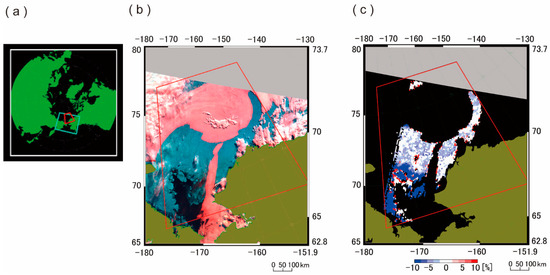
Figure 3.
Comparison of the AMSR-E and MODIS SICs. The AMSR-E SIC was validated using the Aqua/MODIS sea ice/cloud flag (MYD29) throughout the Northern and Southern Hemispheres. The figure represents a sample of the validated area. (a) Validation area map (26 June 2006, 14:10 UTC). (b) Aqua/MODIS RGB (R: 7 ch G: 2 ch B: 1 ch). Pink and white are clouds, blue is sea ice, black is open water, and gray is no observation. (c) SIC differences between AMSR-E and MODIS (AMSR-E minus MODIS equals difference). To validate the AMSR-E SIC, clear-sky pixels (80% cloud-free) were selected. MODIS SIC was derived as a fraction of the MYD29 sea ice flag (spatial resolution of 1 km) within the AMSR-E footprint size (14.4 × 8.2 km).
AMSR-E SIC was slightly biased compared with that of MODIS (Figure 3c). The open water may be contaminated by a small fraction of thick ice or dark new ice. AMSR-E had not only a coarser spatial resolution than MODIS but also did not distinguish melting thin ice as sea ice. Therefore, AMSR-E could not detect a small fraction of sea ice in the melting area near the ice edge (Figure 4) [31,32]. Therefore, AMSR-E SIC was lower than that of MODIS near the sea ice edge. In particular, the AMSR-E SIC was underestimated in areas with 50–70% SIC in both hemispheres and 70–90% SIC in the Southern Hemisphere (Figure 5). The SIC biases of other ranges were close to zero (Figure 5). Fortunately, the underestimation at the AMSR-E SIC of 50–70% and 70–90% did not affect the SIE estimation because Comiso and Nishio [4] defined SIE as the sum of the area with an SIC larger than 15%.
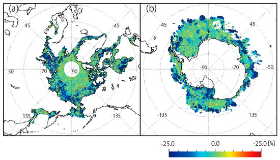
Figure 4.
Differences in the SIC between AMSR-E and MODIS (AMSR-E minus MODIS equals difference) were plotted in the (a) Northern and (b) Southern Hemispheres in 2006.
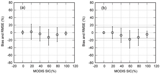
Figure 5.
Root-mean-square error (RMSE) and bias (AMSR-E minus MODIS) of AMSR-E compared with those of MODIS in the entire (a) Northern and (b) Southern Hemispheres in 2006. MODIS SIC = 0, 20, 40, 60, 80, and 100% plot indicates the average RMSE and bias of MODIS SIC = 0%, 0% < SIC ≤ 30%, 30% < SIC ≤ 50%, 50% < SIC ≤ 70%, 70% < SIC ≤ 90%, and 90% < SIC ≤ 100%, respectively. The horizontal solid lines show −15% and 15% bias.
During the refreezing season, the AMSR-E SIC was higher than that of MODIS. MODIS misclassified the dark thin sea ice and cloud shadows over the sea ice as water; however, AMSR2 correctly identified it as sea ice (Figure 3c, red area). The NIC ice charts are useful for detecting this type of error in MODIS SIC.
The root-mean-square error (RMSE) of the AMSR-E SIC was 5–20% depending on the SIC ranges in the Northern and Southern Hemispheres (Figure 5). In this study, we were using the MODIS estimates as the baseline “truth”, and the RMSE/bias of PMRs was relative to MODIS. The average RMSE was approximately 15% in both hemispheres (Table 3). Following the validation, we concluded that AMSR-E SIC was valid for SIC values > 15%. This validation result met the AMSR-E SIC threshold for estimating SIE [4]. We confirmed that it was correct to define the SIE as the areal sum of the ocean area with an SIC of >15%. Applying this definition, long-term SIE trends were obtained based on the AMSR-E equivalent SIE data, considered more precise than those based on SSM/I with a coarser spatial resolution at the sea ice edge.

Table 3.
Validation results by comparing the AMSR-E data with MODIS data in the Northern (N) and Southern (S) Hemispheres in 2006.
3.2. SIC Threshold to Estimate SIE Trends
Figure 6 shows the SIE of SSM/I before (Figure 6a) and after (Figure 6b) the adjustment of the SIC threshold to estimate the continuous SIE trends. The effect of sea ice edge biases on SIE was slightly greater during summer than winter (Figure 6a). However, we confirmed that the sea ice edge bias was almost constant throughout the year, allowing the continuous monitoring of sea ice trends. The SSM/I SIC threshold was determined as the value that minimized the SIE difference between AMSR-E and SSM/I during a one year overlapping period (Figure 6b). Consequently, the mean SIE difference for AMSR-E and SSM/I decreased from 0.17 (km2) to 0.02 (km2) and the mean SIE standard deviation of the difference between AMSR-E and SSM/I changed from 0.07 (km2) to 0.06 (km2) by the adjustment.
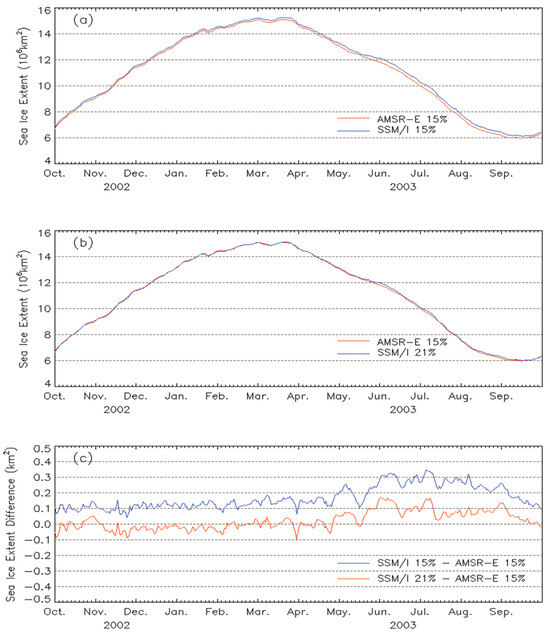
Figure 6.
Time-series of sea ice extent (a) before adjusting the SIC threshold value (SSMI SIC > 15% (blue line) and AMSR-E > 15% (red line)) and (b) after adjusting the SIE of SSM/I to that of AMSR-E (SSMI SIC > 21% (blue line) and AMSR-E > 15% (red line)), and (c) time-series of sea ice extent difference of SSM/I and AMSR-E before adjusting (blue line) and after adjusting (red line) in the Northern Hemisphere.
For SSM/I, the SIC threshold was 22% for the Northern Hemisphere and 21% for the Southern Hemisphere; for WindSat, it was 19% for both the Northern and Southern Hemispheres; and for AMSR2, it was 16% for the Northern Hemisphere and 17% for the Southern Hemisphere. The differences in the resulting thresholds between the Northern and Southern Hemispheres were within 1%; therefore, the SIC threshold value was defined to be constant in the Northern and Southern Hemispheres and over a year for all PMR sensors (Table 4). Consequently, although the overlapping period of SMMR and SSM/I was only six weeks of summer for the Northern Hemisphere and winter for the Southern Hemisphere, we used the same method as the other sensors for SMMR. For long-term analytical studies, consistency in the SIE determination method is crucial. Hence, the approach described above was used to correct the effect of sea ice edge bias on SIE estimation for all PMR sensors. We illustrated that the SIC threshold value depended on the difference in resolution (Table 4), with the only exception of the SMMR case. The IFOV of SMMR is finer than that of SSM/I; however, visual comparison of sea ice images showed that practical spatial resolution of SMMR seemed to be coarser (or at least comparable). One possible reason is SMMR’s low main-beam efficiencies (less than 90%), which may degrade the spatial resolution. This could be the reason of high SIC threshold of SMMR.

Table 4.
SIC threshold for adjusting the SIE difference equal to zero.
3.3. SIE Trends
We developed a long-term daily SIE dataset from November 1978 to the present based on AMSR-E. Long-term daily SIE was determined from the AMSR-E SIC and intersensor bias-corrected SIC of the SMMR, SSM/I, WindSat, and AMSR2. The resulting continuous 45-year SIE data revealed that the minimum SIE in the 2010s (3.53 million km2) was approximately 50% of that in the 1980s (6.86 million km2) in the Northern Hemisphere. Further, the SIE trends were negative in the Northern Hemisphere (Figure 7a). The minimum Arctic SIE was recorded in September 2012. In contrast, the Antarctic SIE increased slightly from 1978 to the early 2010s (Figure 7b). The maximum Antarctic SIE was observed in September 2014. However, the Antarctic SIE exhibited a decreasing trend from the late 2010s, showing a minimum value in the satellite observation records in February 2023. Furthermore, the total (Northern and Southern Hemispheres) SIE reached a record minimum of 15.7 million km2 on 11 February 2023 (Figure 7c and Figure 8).
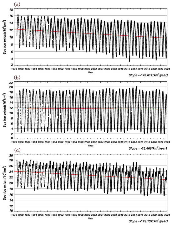
Figure 7.
AMSR-E-based daily sea ice extent (12.5 km resolution) trends in (a) the Northern Hemisphere; (b) the Southern Hemisphere; and (c) both hemispheres for 45 years, i.e., from 1 November 1978, to 31 December 2023. The red lines are the sea ice extent trend per year.
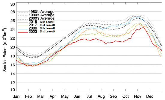
Figure 8.
AMSR-E-based global yearly sea ice extent trends. The red, orange, green, and blue lines show the first, second, third, and fourth lowest SIE from November 1978 to December 2023, respectively. The first, second, third, and fourth lowest SIE were reached in 2023, 2018, 2017, and 2006, respectively. The lightest gray, light gray, and gray dotted lines show the average SIE in the 1980s, 1990s, and 2000s, respectively.
4. Discussion
Long-term sea ice trends are necessary for climate change monitoring. Various PMRs have monitored sea ice distribution. We developed a method for estimating sea ice trends by combining the SMMR, SSM/I series, and AMSR series. As described in Section 2.1, as various PMRs could not acquire TBs at the same frequency channel set, we calibrated the TB and tuned the SIC algorithm to that of the AMSR-E. Subsequently, we eliminated the land contaminated TB because it resembled that of sea ice. Finally, we adjusted the SIC threshold value of each sensor to estimate the SIE trends by eliminating the influence of the difference in the spatial resolution of the sensors. Consequently, we corrected the bias caused by the differences among the sensors and retrieved 45-year long-term sea ice trends.
Conversely, several SIE datasets have been produced to reveal sea ice trends using SSM/I series data, as listed in Table 2 (e.g., Goddard Bootstrap, NASA team, and OSI-SAF, which were compared with our SIE datasets) [33,34]. These SIEs derived from SSM/I series were higher than that of our datasets (Figure 9). The resolution of AMSR-E is higher than that of SSM/I, and the sea ice edge of SSM/I is farther from the correct point than that of AMSR-E. Therefore, the SIE from the SSM/I series was higher than that of AMSR-E. Figure 10 shows the AMSR-E SIEs derived with the SSM/I-based land–ocean flag and those with the AMSR-E-based land–ocean flag. The similar feature shown in Figure 9 can also be observed in Figure 10, i.e., the use of the coarser land–ocean mask led to SIE overestimation. The SIE datasets derived from the SSM/I series used the land–ocean flag in a 25 km grid box based on the SSM/I map (hereafter referred to as “old land”). For the datasets derived from AMSR-E, SIC processing was performed before individual swaths were interpolated onto the grid; therefore, we used the land–ocean flag with the AMSR-E 18 GHz footprint size (hereafter referred to as “new land”). The new land mask reduced the misclassification of false sea ice pixels owing to higher resolution and improvements in the geometric precision of the AMSR-E sensor. Consequently, the SIE difference in winter was larger than that in summer. In the Antarctic Ocean, the AMSR-E SIE was similar for both cases using the new and old land masks (Figure 10). The effect of the land filter on the Antarctic was also small (Figure 11) because the coastlines are less detailed in the Antarctic. Regarding the effect of the land filter on the Arctic Ocean, the AMSR-E SIE decreased by 3.5–4.5% in summer and 1.5–2.5% in winter compared with the unfiltered cases (Figure 11). The Arctic SIE with the new land mask was 5.0–6.0% smaller than that with the old land mask (Figure 10). Therefore, the effect of the land filter was smaller than those of the land–ocean flag.
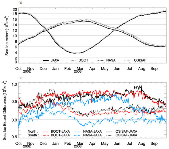
Figure 9.
(a) Daily sea ice extent (SIE) trends of JAXA, OSISAF, BOOT, and NASA from October 2002 to September 2003 in the Northern Hemisphere (lines with increasing to decreasing curves) and Southern (lines with decreasing to increasing curves) Hemisphere. “JAXA” is the dataset in this study. “BOOT” is the Goddard bootstrap product at NSIDC (NSIDC-0192 in Table 2). “NASA” means NASA Team product (G0192 in Table 2). “OSISAF” is OSI-SAF (Bristol/Bootstrap) product (OSI-420 in Table 2) at EUMETSAT. The black solid line and lightest gray, light gray, and gray dotted lines show the SIE of JAXA, OSISAF, BOOT, and NASA, respectively. (b) Difference of daily sea ice extent among the JAXA, OSISAF, BOOT, and NASA in the Northern Hemisphere (solid line) and Southern Hemisphere (dashed line). The differences of BOOT–JAXA, NASA–JAXA, and OSISAF–JAXA are the red, blue, and black lines, respectively.
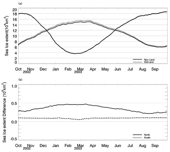
Figure 10.
(a) AMSR-E daily sea ice extent (SIE) trends derived from different land–ocean flags from October 2002 to September 2003 in Northern (lines with increasing to decreasing curves) and Southern (lines with decreasing to increasing curves) Hemispheres. The solid line represents new land, and the dashed line indicates old land. The new land is AMSR-E-based, and the old land is SSM/I-based. (b) Difference of sea ice extent with new and old land in Northern (solid line) and Southern (dashed line) Hemispheres.
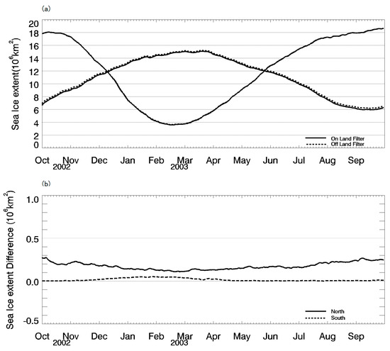
Figure 11.
(a) Effect of land filter on the AMSR-E daily sea ice extent (SIE) trends from October 2002 to September 2003 in Northern (lines with increasing to decreasing curves) and Southern (lines with decreasing to increasing curves) Hemispheres. The solid line represents the SIE applied to the land filter, and the dashed line indicates the SIE of the no land filter. (b) Difference of applying land filter and no land filter in Northern (solid line) and Southern Hemispheres (dashed line).
Although it is still difficult to estimate accurate sea ice distributions near the coastal areas due to TB contamination, the derived long-term sea ice data revealed that the global SIE remarkably decreased in the late 2010s and reached a record low in February 2023 (Figure 8).
5. Conclusions
In this study, we estimated the SIC bias between AMSR-E and other PMRs and retrieved long-term trends in the sea ice extent by correcting the bias among PMRs based on AMSR-E. Consequently, we obtained the drastic negative trends of SIE occurring worldwide.
The intersensor SIC bias originated from the difference in the spatial resolution of PMR sensors after the intersensor calibration of TBs, SIC algorithm tuning, and rejection of land contamination. To correct the frequency difference in TBs of different sensors, we (1) calibrated the TB to AMSR-E at higher SICs (≥80%); (2) adjusted the open water tie-point of the SIC algorithm; and (3) adjusted the open ocean mask line of the SIC algorithm. After corrections, we calculated the SIC using the same algorithm (ABA). We then resolved the difference in land contamination owing to the difference in geometric precision. As land contaminated TBs can easily be identified as sea ice, the following methods were used: (1) the land mask was unified to that of AMSR-E and (2) a land filter was applied. Subsequently, to eliminate the difference in observation time and swath width among different sensors, we calculated the daily SIC based on the 5-day average. Finally, to resolve differences in spatial resolution, we determined the SIC threshold to match the sea ice edge with that of AMSR-E.
AMSR-E data have higher resolution and better accuracy than the SSM/I series data. Nevertheless, they have not been used in studies of sea ice trends due to the unknown bias from the previous PMRs and the shorter operation period, as compared to that of the SSM/I and SSMIS series dataset. However, the SSM/I and SSMIS series have no future successors (except for the MicroWave Imager (MWI) on the Weather System Follow-on (WSF) platform launched in April 2024 by the US Defense Department). Therefore, we developed a method for combining AMSR-E with SSM/I and other PMRs datasets for climate change analysis. This is the first combination of a sea ice trend dataset with SMMR, SSM/I series, and AMSR series data for climate studies. Our dataset can be also used for climate models. These data were provided by the JAXA Satellite Monitoring for Environmental Studies (JASMES) Climate Sea Ice Dataset Version 2 (https://kuroshio.eorc.jaxa.jp/JASMES/climate/index.html, accessed on 31 Junuary 2024). We provide daily SIC and SIE data from this website. Our SIE data were obtained based on AMSR-E equivalent SIC with a resolution 12.5 km. We retrieved the long-term sea ice dataset based on AMSR-E because it was the first AMSR series sensor following the SSM/I series. Using this method, additional long-term SIE trends for approximately half a century will be available through the extended operation of AMSR2 and subsequent missions (e.g., AMSR3). AMSR2, the successor of AMSR-E, provides the highest spatial resolution among the successive PMRs. Therefore, we intend to reanalyze our datasets using AMSR2 as reference data in the future.
Author Contributions
Conceptualization, methodology, validation, formal analysis, investigation, and resources, M.S., M.H., K.N., M.K., and K.I.; software, data curation and writing—original draft preparation, M.S.; writing—review and editing, M.H., K.N., M.K., and K.I.; supervision, M.H.; project administration, M.H. All authors have read and agreed to the published version of the manuscript.
Funding
This study received no external funding.
Data Availability Statement
The WindSat Sensor Data Record (SDR) brightness temperatures were provided by the Naval Research Laboratory (NRL) and the National Environmental Satellite Data and Information Service (NESDIS). SSM/I antenna temperature (TA) data were obtained using remote sensing systems (RSS). The Nimbus-7 SMMR Pathfinder Brightness Temperature Data were provided by the Jet Propulsion Laboratory, California Institute of Technology, Pasadena, California, in contract with the National Aeronautics and Space Administration (NASA).
Acknowledgments
We wish to thank K. Nakagawa, H. Fukushima, and R. Okada from the Japan Meteorological Agency; K. Cho from Tokai University; and J. C. Comiso from NASA for their constructive suggestions and discussions. Furthermore, we appreciate the programming support provided by K. Sekiya, K. Kouhara, and T. Mutoh from the Remote Sensing Technology Center of Japan.
Conflicts of Interest
The authors declare no conflicts of interest.
References
- Cavalieri, D.J.; Parkinson, C.L.; Gloersen, P.; Zwally, H.J. Sea Ice Concentrations from Nimbus-7 SMMR and DMSP SSM/I-SSMIS Passive Microwave Data, Version 1; NASA National Snow and Ice Data Center Distributed Active Archive Center: Boulder, CO, USA, 1996. [Google Scholar] [CrossRef]
- Comiso, J.C. Bootstrap Sea Ice Concentrations from Nimbus-7 SMMR and DMSP SSM/I-SSMIS, Version 3; NASA National Snow and Ice Data Center Distributed Active Archive Center: Boulder, CO, USA, 2017. [Google Scholar] [CrossRef]
- Lavergne, T.; Sørensen, A.M.; Kern, S.; Tonboe, R.; Notz, D.; Aaboe, S.; Bell, L.; Dybkjær, G.; Eastwood, S.; Gabarro, C.; et al. Version 2 of the EUMETSAT OSI SAF and ESA CCI sea-ice concentration climate data records. Cryosphere 2019, 13, 49–78. [Google Scholar] [CrossRef]
- Comiso, J.C.; Nishio, F. Trends in the sea ice cover using enhanced and compatible AMSR-E, SSM/I and SMMR Data. J. Geophys. Res. 2008, 113, C02S07. [Google Scholar] [CrossRef]
- Long, D.G.; Brodzik, M.J. Optimum image formation for spaceborne microwave radiometer products. IEEE Trans. Geosci. Remote Sens. 2016, 54, 2763–2779. [Google Scholar] [CrossRef] [PubMed]
- Comiso, J.C.; Meier, W.N.; Gersten, R. Variability and trends in the Arctic Sea ice cover: Results from different techniques. J. Geophys. Res.-Ocean. 2017, 122, 1226883–1226900. [Google Scholar] [CrossRef]
- Wentz, F.J. User’s Manual, SSM/I Antenna Temperature Tapes, 1st Revision; Technical Report 120191; Remote Sensing Systems: Santa Rosa, CA, USA, 1991. [Google Scholar]
- Wentz, F.J. User’s Manual, SSM/I Antenna Temperature Tapes, 2nd Revision; Technical Report 120193; Remote Sensing Systems: Santa Rosa, CA, USA, 1993. [Google Scholar]
- Wentz, F.J. User’s Manual, SSM/I Antenna Temperature, Version 6; Technical Memo 082806; Remote Sensing Systems: Santa Rosa, CA, USA, 2006. [Google Scholar]
- Lin, G.; Li, L.; Weiser, P. Sea ice retrievals from Windsat data. In Proceedings of the 2006 IEEE International Symposium on Geoscience and Remote Sensing, Denver, CO, USA, 31 July–4 August 2006; pp. 730–733. [Google Scholar]
- Njoku, E.G.; Rague, B.; Fleming, K. The Nimbus-7 SMMR Pathfinder Brightness Temperature Data Set; Jet Propulsion Laboratory Publication: Pasadena, CA, USA, 1999. [Google Scholar]
- Gaiser, P.W.; Germain, K.M.S.; Twarog, E.M.; Poe, G.A.; Purdy, W.; Richardson, D.; Grossman, W.; Jones, W.L.; Spencer, D.; Golba, G.; et al. The WindSat spaceborne polarimetric microwave radiometer: Sensor description and early orbit performance. IEEE Trans. Geosci. Remote Sens. 2004, 42, 2347–2361. [Google Scholar] [CrossRef]
- King, M.D.; Platnick, S.; Menzel, W.P.; Ackerman, S.A.; Hubanks, P.A. Spatial and temporal distribution of clouds observed by MODIS onboard the Terra and Aqua Satellites. IEEE Trans. Geosci. Remote Sens. 2013, 51, 3826–3852. [Google Scholar] [CrossRef]
- Baum, B.A.; Menzel, W.P.; Frey, R.A.; Tobin, D.C.; Holz, R.E.; Ackerman, S.A.; Heidinger, A.K.; Yang, P. MODIS cloud-top property refinement for collection 6. J. Appl. Meteorol. Climatol. 2012, 51, 1145–1163. [Google Scholar] [CrossRef]
- Riggs, G.A.; Hall, D.K.; Ackerman, S.A. Sea ice extent and classification mapping with the moderate resolution imaging spectroradiometer airborne simulator. Remote Sens. Environ. 1999, 68, 152–163. [Google Scholar] [CrossRef]
- Fetterer, F.; Fowler, C. National Ice Center Arctic Sea Ice Charts and Climatology; NSIDC: Boulder, CO, USA, 2006. [Google Scholar]
- Fetterer, F. A Selection of Documentation Related to National Ice Center Sea Ice Charts in Digital Format; National Snow and Ice Data Center (NSIDC): Boulder, CO, USA, 2006. [Google Scholar]
- Fetterer, F.; Knowles, K.; Meiser, W.; Savoie, M.; Windnagel, A.K. Sea Ice Index, Version 3; NSIDC National Snow and Ice Data Center: Boulder, CO, USA, 2017. [Google Scholar]
- Stroeve, J.; Meier, W.N. Sea Ice Trends and Climatologies from SMMR and SSM/I-SSMIS. (NSIDC-0192, Version 3); NASA National Snow and Ice Data Center Distributed Active Archive Center: Boulder, CO, USA, 2018. [Google Scholar] [CrossRef]
- OSI SAF Sea Ice Index 1978-Onwards, Version 2.1, OSI-420; EUMETSAT Ocean and Sea Ice Satellite Application Facility: Darmstadt, Germany, 2020.
- DiGirolamo, N.; Parkinson, C.L.; Cavalieri, D.J.; Gloersen, P.; Zwally, H.J. Sea Ice Concentrations from Nimbus-7 SMMR and DMSP SSM/I-SSMIS Passive Microwave Data. (NSIDC-0051, Version 2); NASA National Snow and Ice Data Center Distributed Active Archive Center: Boulder, CO, USA, 2022. [Google Scholar] [CrossRef]
- OSI SAF: Global Sea Ice Concentration Climate Data Record 1978–2020, (OSI-450-a, v3.0); EUMETSAT Ocean and Sea Ice Satellite Application Facility: Darmstadt, Germany, 2022. [CrossRef]
- Comiso, J.C.; Parkinson, C.L. Arctic sea ice parameters from AMSR-E data using two techniques and comparison with sea ice from SSM/I. J. Geophys. Res. 2008, 113, C02S05. [Google Scholar] [CrossRef]
- Comiso, J.C. Enhanced sea ice concentrations and ice extents from AMSR-E data. J. Remote Sens. Jpn. 2009, 29, 199–215. [Google Scholar]
- Cho, K.; Sasaki, N.; Shimoda, H.; Sakata, T.; Nishio, F. Evaluation and improvement of SSM/I sea ice concentration algorithms for the Sea of Okhotsk. J. Remote Sens. Jpn. 1996, 16, 47–58. [Google Scholar]
- Kurihara, Y.; Sakurai, T.; Kuragano, T. Global daily sea surface temperature analysis using data from satellite microwave radiometer, satellite infrared radiometer and in-situ observations. Weather. Serv. Bull. 2006, 73, 1–18. (In Japanese) [Google Scholar]
- Bjørgo, E.; Johannessen, O.M.; Miles, M.W. Analysis of merged SMMR-SSMI time series of Arctic and Antarctic Sea ice parameters 1978–1995. Geophys. Res. Lett. 1997, 24, 413–416. [Google Scholar] [CrossRef]
- Gloersen, P.; Campbell, W.J.; Cavalieri, D.J.; Comiso, J.C.; Parkinson, C.L.; Zwally, H.J. Satellite passive microwave observations and analysis of Arctic and Antarctic sea ice 1978–1987. Ann. Glaciol. 1993, 17, 149–154. [Google Scholar] [CrossRef]
- Lu, J.; Heygster, G.; Spreen, G. Atmospheric correction of sea ice concentration retrieval for 89 GHz AMSR-E observations. IEEE J. Sel. Top. Appl. Earth Obs. Remote Sens. 2018, 11, 1442–1457. [Google Scholar] [CrossRef]
- Tonboe, R.T.; Eastwood, S.; Lavergne, T.; Sørensen, A.M.; Rathmann, N.; Dybkjær, G.; Pedersen, L.T.; Høyer, J.L.; Kern, S. The EUMETSAT sea ice concentration climate data record. Cryosphere 2016, 10, 2275–2290. [Google Scholar] [CrossRef]
- Cavalieri, D.J.; Markus, T.; Hall, D.K.; Ivanoff, A.; Glick, E. Assessment of AMSR-E Antarctic winter sea-ice concentrations using Aqua MODIS. IEEE Tran. Geosci. Remote Sens. 2010, 48, 1442–1457. [Google Scholar] [CrossRef]
- Kern, S.; Rösel, A.; Pedersen, L.T.; Ivanova, N.; Saldo, R.; Tonboe, R.T. The impact of melt ponds on summertime microwave brightness temperatures and sea-ice concentrations. Cryosphere 2016, 10, 2217–2239. [Google Scholar] [CrossRef]
- Meier, W.N.; Stewart, J.S. Assessing uncertainties in sea ice extent climate indicators. Environ. Res. Lett. 2019, 14, 035005. [Google Scholar] [CrossRef]
- Kern, S.; Lavergne, T.; Notz, D.; Pedersen, L.T.; Tonboe, R.T.; Saldo, R.; Sørensen, A.M. Satellite passive microwave sea-ice concentration data set intercomparison: Closed ice and ship-based observations. Cryosphere 2019, 13, 3261–3307. [Google Scholar] [CrossRef]
Disclaimer/Publisher’s Note: The statements, opinions and data contained in all publications are solely those of the individual author(s) and contributor(s) and not of MDPI and/or the editor(s). MDPI and/or the editor(s) disclaim responsibility for any injury to people or property resulting from any ideas, methods, instructions or products referred to in the content. |
© 2024 by the authors. Licensee MDPI, Basel, Switzerland. This article is an open access article distributed under the terms and conditions of the Creative Commons Attribution (CC BY) license (https://creativecommons.org/licenses/by/4.0/).