Temporal Dynamics of Global Barren Areas between 2001 and 2022 Derived from MODIS Land Cover Products
Abstract
1. Introduction
2. Materials and Methods
2.1. Datasets
2.2. Research Methods
3. Results
3.1. Spatiotemporal Dynamics of Barren Areas
3.2. Transition Dynamics between Barren Areas and Other Land Cover Units
4. Discussion
5. Conclusions
- The use of MaxE provided the opportunity to conduct detailed analysis of the spatiotemporal changes, as any annual change observed in the barren distribution was comparable over the entire dataset.
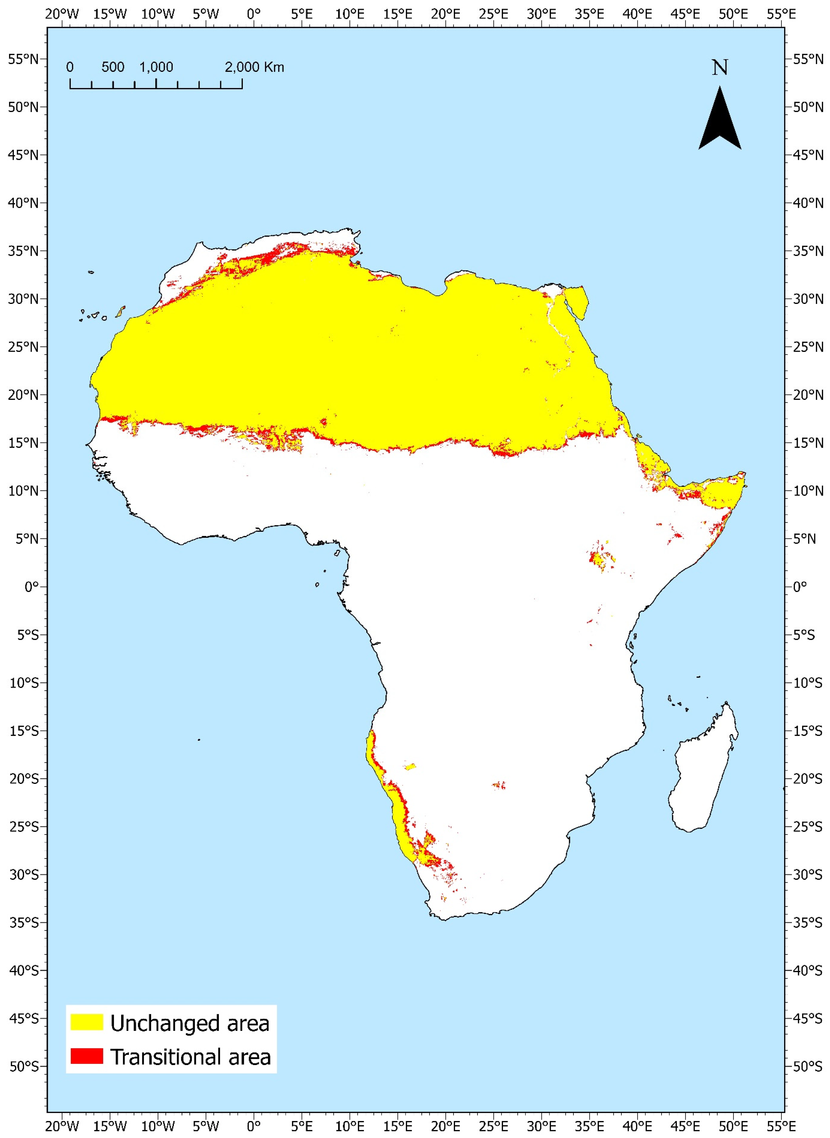
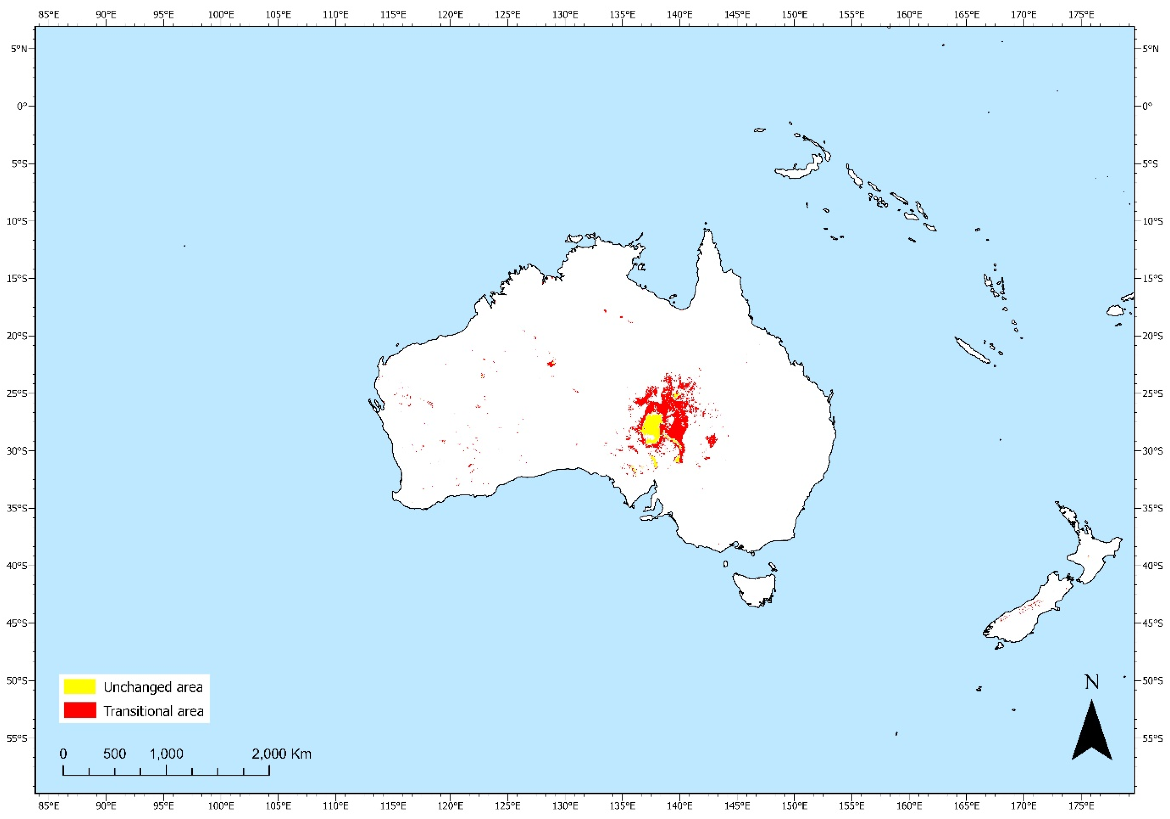
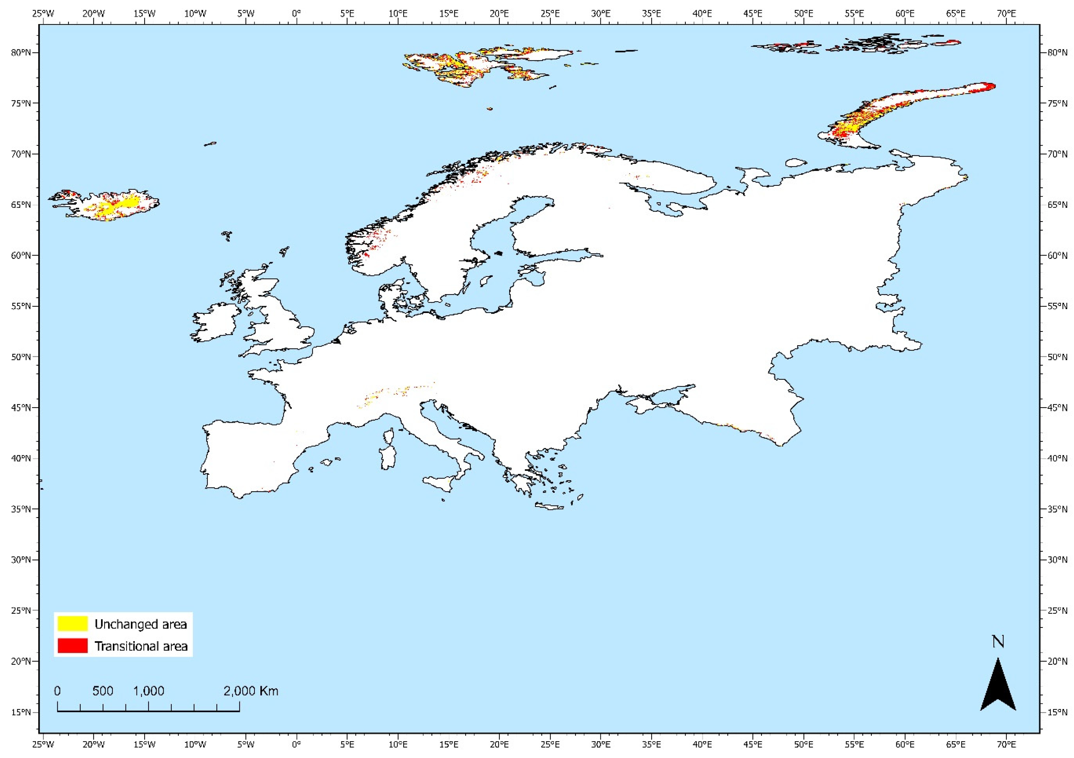
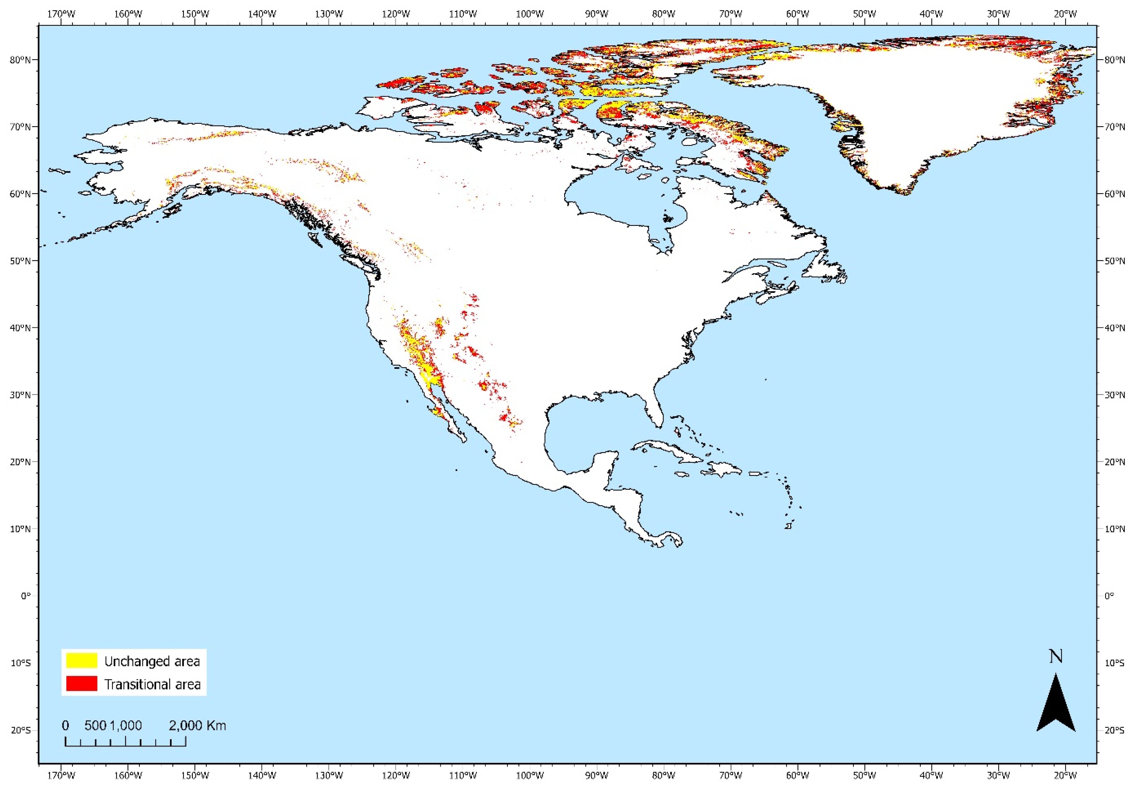
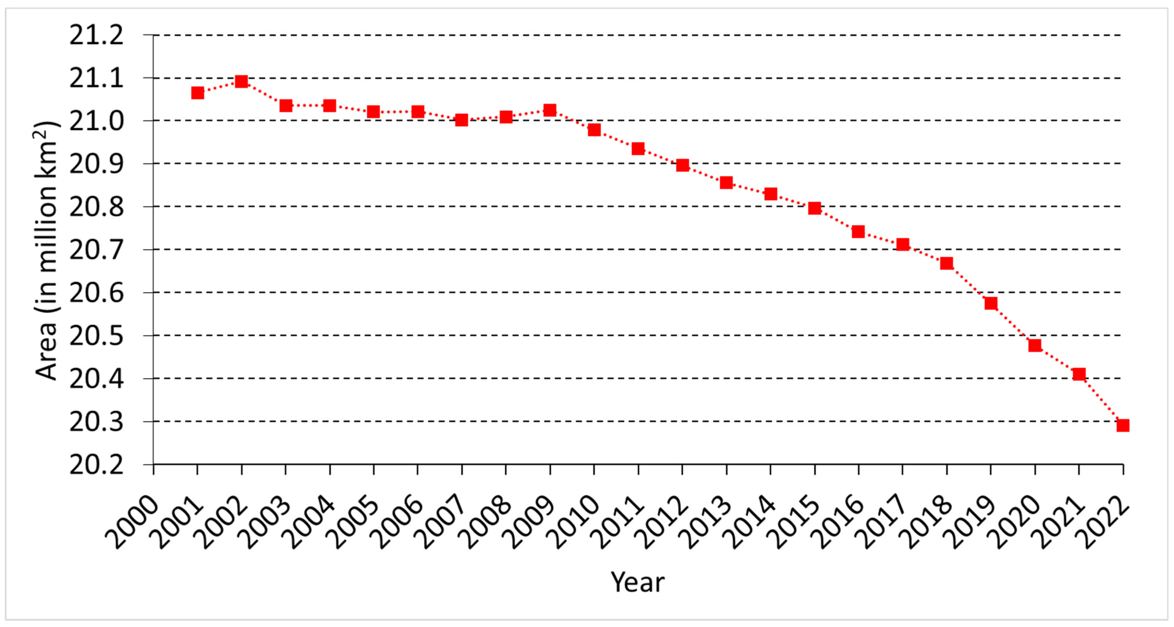
- A large portion of the barren areas remained unchanged for 22 years. This portion is equivalent to 12.8% of the global land surface area. However, the results indicated a 3.7% decrease in global barren areas from 2001 to 2022, mainly due to transitions to grasslands and open shrublands.
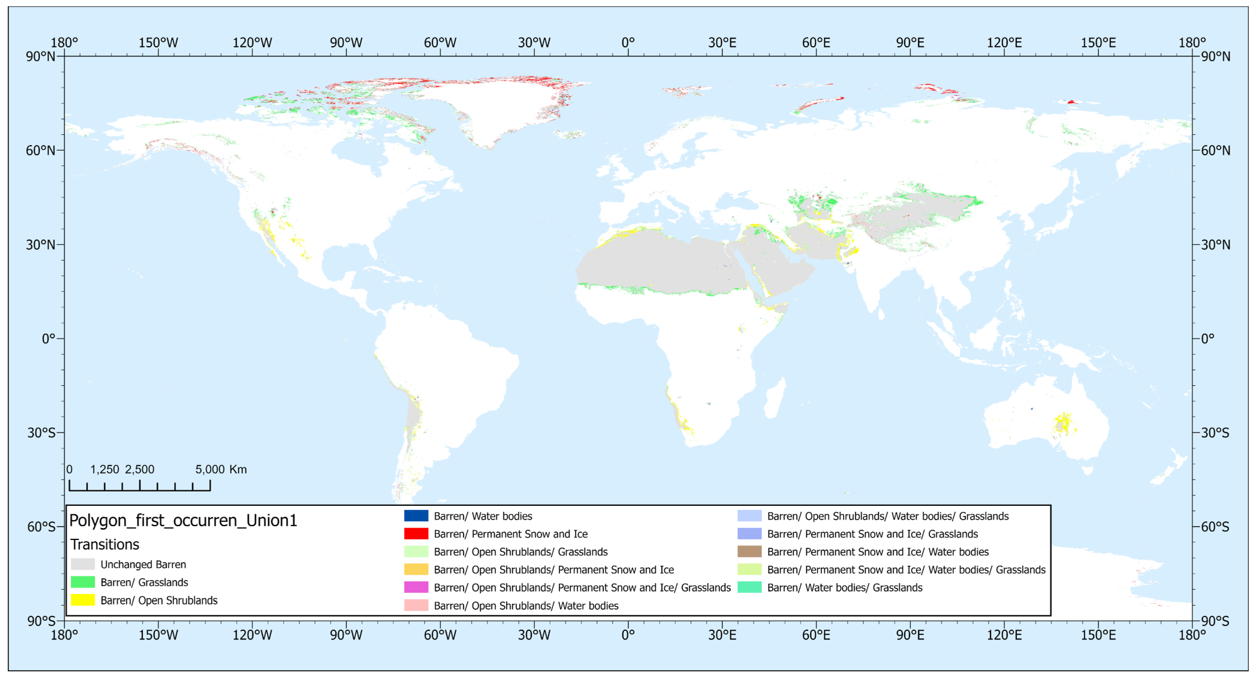
- Barren transitional areas, which constitute approximately 2.3% of the global land surface area, are found to be highly dynamic both in space and time. Different barren transitions were found for different regions of the world. Particularly, transitions to open shrublands can be found in the majority of the barren regions, whereas grasslands are mostly limited to the Northern Hemisphere. Barren areas that are present in the artic regions revealed interchanges, mainly between snow and ice and water bodies. On a global scale, barren to grassland, open shrublands transitions, permanent snow and ice, and water bodies account for 50.3%, 26.6%, 8.3% and 2.2% of the transitional area, respectively. Barren transitional areas are also found to exhibit strong temporal variations, as shown by their high relative changes over time.
- The fragility of some ecosystems has been revealed, as areas that predominantly consist of other land cover classes (90–100% TO) account for 30.6% of the transitional areas. Also, this study identified emerging barren hotspot areas in the Mangystau region (Kazakhstan), the Tibetan plateau, Northern Greenland, and the Atlas Mountains, which is in agreement with recent published studies on land changes in these regions. Up-to-date information on the land cover will provide the opportunity to monitor the evolution of these regions.
Author Contributions
Funding
Data Availability Statement
Acknowledgments
Conflicts of Interest
Appendix A
Maps of the Unchanged (UA) and Transitional (TA) Barren Areas Per Continent


References
- Wang, Z.; Wu, J.; Niu, B.; He, Y.; Zu, J.; Li, M.; Zhang, X. Vegetation Expansion on the Tibetan Plateau and Its Relationship with Climate Change. Remote Sens. 2020, 12, 4150. [Google Scholar] [CrossRef]
- Ding, Y.; Feng, Y.; Chen, K.; Zhang, X. Analysis of Spatial and Temporal Changes in Vegetation Cover and Its Drivers in the Aksu River Basin, China. Sci. Rep. 2024, 14, 10165. [Google Scholar] [CrossRef] [PubMed]
- Dasgupta, B.; Sanyal, P. Linking Land Use Land Cover Change to Global Groundwater Storage. Sci. Total Environ. 2022, 853, 158618. [Google Scholar] [CrossRef] [PubMed]
- Eliades, M.; Michaelides, S.; Evagorou, E.; Fotiou, K.; Fragkos, K.; Leventis, G.; Theocharidis, C.; Panagiotou, C.F.; Mavrovouniotis, M.; Neophytides, S.; et al. Earth Observation in the EMMENA Region: Scoping Review of Current Applications and Knowledge Gaps. Remote Sens. 2023, 15, 4202. [Google Scholar] [CrossRef]
- Pandey, P.C.; Koutsias, N.; Petropoulos, G.P.; Srivastava, P.K.; Ben Dor, E. Land Use/Land Cover in View of Earth Observation: Data Sources, Input Dimensions, and Classifiers—A Review of the State of the Art. Geocarto Int. 2021, 36, 957–988. [Google Scholar] [CrossRef]
- Buchhorn, M.; Lesiv, M.; Tsendbazar, N.-E.; Herold, M.; Bertels, L.; Smets, B. Copernicus Global Land Cover Layers—Collection 2. Remote Sens. 2020, 12, 1044. [Google Scholar] [CrossRef]
- Friedl, M.A.; Sulla-Menashe, D.; Tan, B.; Schneider, A.; Ramankutty, N.; Sibley, A.; Huang, X. MODIS Collection 5 Global Land Cover: Algorithm Refinements and Characterization of New Datasets. Remote Sens. Environ. 2010, 114, 168–182. [Google Scholar] [CrossRef]
- Phiri, D.; Simwanda, M.; Salekin, S.; Nyirenda, V.R.; Murayama, Y.; Ranagalage, M. Sentinel-2 Data for Land Cover/Use Mapping: A Review. Remote Sens. 2020, 12, 2291. [Google Scholar] [CrossRef]
- Zhang, C.; Li, X. Land Use and Land Cover Mapping in the Era of Big Data. Land 2022, 11, 1692. [Google Scholar] [CrossRef]
- Jing, Q.; He, J.; Li, Y.; Yang, X.; Peng, Y.; Wang, H.; Yu, F.; Wu, J.; Gong, S.; Che, H.; et al. Analysis of the Spatiotemporal Changes in Global Land Cover from 2001 to 2020. Sci. Total Environ. 2024, 908, 168354. [Google Scholar] [CrossRef]
- Zhang, X.; Zhao, T.; Xu, H.; Liu, W.; Wang, J.; Chen, X.; Liu, L. GLC_FCS30D: The First Global 30 m Land-Cover Dynamics Monitoring Product with a Fine Classification System for the Period from 1985 to 2022 Generated Using Dense-Time-Series Landsat Imagery and the Continuous Change-Detection Method. Earth Syst. Sci. Data 2024, 16, 1353–1381. [Google Scholar] [CrossRef]
- Nie, T.; Dong, G.; Jiang, X.; Lei, Y. Spatio-Temporal Changes and Driving Forces of Vegetation Coverage on the Loess Plateau of Northern Shaanxi. Remote Sens. 2021, 13, 613. [Google Scholar] [CrossRef]
- Zhai, H.; Lv, C.; Liu, W.; Yang, C.; Fan, D.; Wang, Z.; Guan, Q. Understanding Spatio-Temporal Patterns of Land Use/Land Cover Change under Urbanization in Wuhan, China, 2000–2019. Remote Sens. 2021, 13, 3331. [Google Scholar] [CrossRef]
- Youssef, Y.M.; Gemail, K.S.; Atia, H.M.; Mahdy, M. Insight into Land Cover Dynamics and Water Challenges under Anthropogenic and Climatic Changes in the Eastern Nile Delta: Inference from Remote Sensing and GIS Data. Sci. Total Environ. 2024, 913, 169690. [Google Scholar] [CrossRef]
- Chowdhury, M.; Hasan, M.E.; Abdullah-Al-Mamun, M.M. Land Use/Land Cover Change Assessment of Halda Watershed Using Remote Sensing and GIS. Egypt. J. Remote Sens. Space Sci. 2020, 23, 63–75. [Google Scholar] [CrossRef]
- Faruque, M.J.; Vekerdy, Z.; Hasan, M.Y.; Islam, K.Z.; Young, B.; Ahmed, M.T.; Monir, M.U.; Shovon, S.M.; Kakon, J.F.; Kundu, P. Monitoring of Land Use and Land Cover Changes by Using Remote Sensing and GIS Techniques at Human-Induced Mangrove Forests Areas in Bangladesh. Remote Sens. Appl. Soc. Environ. 2022, 25, 100699. [Google Scholar] [CrossRef]
- Quamar, M.M.; Al-Ramadan, B.; Khan, K.; Shafiullah, M.; El Ferik, S. Advancements and Applications of Drone-Integrated Geographic Information System Technology—A Review. Remote Sens. 2023, 15, 5039. [Google Scholar] [CrossRef]
- Kumar, M.; Singh, R.B.; Singh, A.; Pravesh, R.; Majid, S.I.; Tiwari, A. (Eds.) Introduction of Geographic Information System. In Geographic Information Systems in Urban Planning and Management; Springer Nature: Singapore, 2023; pp. 3–24. ISBN 978-981-19785-5-5. [Google Scholar]
- Brown, A.G.; Tooth, S.; Bullard, J.E.; Thomas, D.S.G.; Chiverrell, R.C.; Plater, A.J.; Murton, J.; Thorndycraft, V.R.; Tarolli, P.; Rose, J.; et al. The Geomorphology of the Anthropocene: Emergence, Status and Implications. Earth Surf. Process. Landf. 2017, 42, 71–90. [Google Scholar] [CrossRef]
- Wang, H.; Liu, Y.; Wang, Y.; Yao, Y.; Wang, C. Land Cover Change in Global Drylands: A Review. Sci. Total Environ. 2023, 863, 160943. [Google Scholar] [CrossRef]
- Winkler, K.; Fuchs, R.; Rounsevell, M.; Herold, M. Global Land Use Changes Are Four Times Greater than Previously Estimated. Nat. Commun. 2021, 12, 2501. [Google Scholar] [CrossRef]
- Liu, H.; Gong, P.; Wang, J.; Clinton, N.; Bai, Y.; Liang, S. Annual Dynamics of Global Land Cover and Its Long-Term Changes from 1982 to 2015. Earth Syst. Sci. Data 2020, 12, 1217–1243. [Google Scholar] [CrossRef]
- Wu, S.; Liu, L.; Li, D.; Zhang, W.; Liu, K.; Shen, J.; Zhang, L. Global Desert Expansion during the 21st Century: Patterns, Predictors and Signals. Land Degrad. Dev. 2023, 34, 377–388. [Google Scholar] [CrossRef]
- Song, X.-P.; Hansen, M.C.; Stehman, S.V.; Potapov, P.V.; Tyukavina, A.; Vermote, E.F.; Townshend, J.R. Global Land Change from 1982 to 2016. Nature 2018, 560, 639–643. [Google Scholar] [CrossRef] [PubMed]
- Lamchin, M.; Bilintoh, T.M.; Lee, W.-K.; Ochir, A.; Lim, C.-H. Exploring Spatio-Temporal Change in Global Land Cover Using Categorical Intensity Analysis. Front. For. Glob. Chang. 2022, 5, 994713. [Google Scholar] [CrossRef]
- Hu, Y.; Han, Y.; Zhang, Y. Land Desertification and Its Influencing Factors in Kazakhstan. J. Arid Environ. 2020, 180, 104203. [Google Scholar] [CrossRef]
- Chen, Y.; Xu, E. The Spatiotemporal Change in Land Cover and Discrepancies within Different Countries on the Qinghai–Tibet Plateau over a Recent 30-Year Period. Land 2023, 12, 1797. [Google Scholar] [CrossRef]
- El Hairchi, K.; Ben Brahim, Y.; Ouiaboub, L.; Limame, A.; Saadi, O.; Nouayti, A. Desertification Modeling in the Moroccan Middle Atlas Using Sentinel-2A Images and TCT Indexes (Case of the Ain Nokra Forest). Model. Earth Syst. Environ. 2023, 9, 4279–4293. [Google Scholar] [CrossRef]
- He, L.; Guo, J.; Yang, W.; Jiang, Q.; Chen, L.; Tang, K. Multifaceted Responses of Vegetation to Average and Extreme Climate Change Over Global Drylands. Sci. Total Environ. 2023, 858, 159942. [Google Scholar] [CrossRef]





| Name | Value | Description |
|---|---|---|
| Water Bodies | 0 | At least 60% of area is covered by permanent water bodies. |
| Evergreen Needleleaf Forests | 1 | Dominated by evergreen conifer trees (canopy >2 m). Tree cover >60%. |
| Evergreen Broadleaf Forests | 2 | Dominated by evergreen broadleaf and palmate trees (canopy >2 m). Tree cover >60%. |
| Deciduous Needleleaf Forests | 3 | Dominated by deciduous needleleaf (larch) trees (canopy >2 m). Tree cover >60%. |
| Deciduous Broadleaf Forests | 4 | Dominated by deciduous broadleaf trees (canopy >2 m). Tree cover >60%. |
| Mixed Forests | 5 | Dominated by neither deciduous nor evergreen (40–60% of each) tree type (canopy >2 m). Tree cover >60%. |
| Closed Shrublands | 6 | Dominated by woody perennials (1–2 m height) >60% cover. |
| Open Shrublands | 7 | Dominated by woody perennials (1–2 m height) 10–60% cover. |
| Woody Savannas | 8 | Tree cover 30–60% (canopy >2 m). |
| Savannas | 9 | Tree cover 10–30% (canopy >2 m). |
| Grasslands | 10 | Dominated by herbaceous annuals (<2 m). |
| Permanent Wetlands | 11 | Permanently inundated lands with 30–60% water cover and >10% vegetated cover. |
| Croplands | 12 | At least 60% of area is cultivated cropland. |
| Urban and Built-up Lands | 13 | At least 30% impervious surface area including building materials, asphalt, and vehicles. |
| Cropland/Natural Vegetation Mosaics | 14 | Mosaics of small-scale cultivation 40–60% with natural tree, shrub, or herbaceous vegetation. |
| Permanent Snow and Ice | 15 | At least 60% of area is covered by snow and ice for at least 10 months of the year. |
| Barren | 16 | At least 60% of area is non-vegetated barren (sand, rock, soil) or permanent snow and ice with less than 10% vegetation. |
| Continent | Total Area (km2) | Unchanged Area (km2) | Maximum Extent (km2) |
|---|---|---|---|
| Africa | 29,904,894 | 9,769,208 | 10,409,215 |
| Asia | 44,906,061 | 7,894,262 | 9,441,675 |
| Australia | 8,115,839 | 72,991 | 271,969 |
| Europe | 9,939,509 | 51,663 | 112,675 |
| North America | 24,266,604 | 452,960 | 1,236,318 |
| South America | 17,703,640 | 594,940 | 755,290 |
Disclaimer/Publisher’s Note: The statements, opinions and data contained in all publications are solely those of the individual author(s) and contributor(s) and not of MDPI and/or the editor(s). MDPI and/or the editor(s) disclaim responsibility for any injury to people or property resulting from any ideas, methods, instructions or products referred to in the content. |
© 2024 by the authors. Licensee MDPI, Basel, Switzerland. This article is an open access article distributed under the terms and conditions of the Creative Commons Attribution (CC BY) license (https://creativecommons.org/licenses/by/4.0/).
Share and Cite
Eliades, M.; Neophytides, S.; Mavrovouniotis, M.; Panagiotou, C.F.; Anastasiadou, M.N.; Varvaris, I.; Papoutsa, C.; Bachofer, F.; Michaelides, S.; Hadjimitsis, D. Temporal Dynamics of Global Barren Areas between 2001 and 2022 Derived from MODIS Land Cover Products. Remote Sens. 2024, 16, 3317. https://doi.org/10.3390/rs16173317
Eliades M, Neophytides S, Mavrovouniotis M, Panagiotou CF, Anastasiadou MN, Varvaris I, Papoutsa C, Bachofer F, Michaelides S, Hadjimitsis D. Temporal Dynamics of Global Barren Areas between 2001 and 2022 Derived from MODIS Land Cover Products. Remote Sensing. 2024; 16(17):3317. https://doi.org/10.3390/rs16173317
Chicago/Turabian StyleEliades, Marinos, Stelios Neophytides, Michalis Mavrovouniotis, Constantinos F. Panagiotou, Maria N. Anastasiadou, Ioannis Varvaris, Christiana Papoutsa, Felix Bachofer, Silas Michaelides, and Diofantos Hadjimitsis. 2024. "Temporal Dynamics of Global Barren Areas between 2001 and 2022 Derived from MODIS Land Cover Products" Remote Sensing 16, no. 17: 3317. https://doi.org/10.3390/rs16173317
APA StyleEliades, M., Neophytides, S., Mavrovouniotis, M., Panagiotou, C. F., Anastasiadou, M. N., Varvaris, I., Papoutsa, C., Bachofer, F., Michaelides, S., & Hadjimitsis, D. (2024). Temporal Dynamics of Global Barren Areas between 2001 and 2022 Derived from MODIS Land Cover Products. Remote Sensing, 16(17), 3317. https://doi.org/10.3390/rs16173317


