Article

Seasonal Dynamics of the Land-Surface Characteristics in Arid Regions Retrieved by Optical and Microwave Satellite Data

1
College of Agriculture, Food and Environment Sciences, Rakuno Gakuen University, Ebetsu 069-0836, Hokkaido, Japan
2
Hokusei Gakuen University Junior College, Sapporo 004-0042, Hokkaido, Japan
3
Zanvyl Krieger School of Arts & Sciences, Johns Hopkins University, Baltimore, MD 21218, USA
4
School of Geography, University of Oxford, Oxford OX1 3QY, UK
5
Department of Geography, National University of Mongolia, Ulaanbaatar 14200, Mongolia
6
College of Veterinary Sciences, Rakuno Gakuen University, Ebetsu 069-0836, Hokkaido, Japan
*
Author to whom correspondence should be addressed.
Remote Sens. 2024, 16(17), 3143; https://doi.org/10.3390/rs16173143
Submission received: 25 June 2024 / Revised: 19 August 2024 / Accepted: 23 August 2024 / Published: 26 August 2024

Abstract

:
Establishing a quantitative relationship between Synthetic Aperture Radar (SAR) data and optical data can facilitate the fusion of these two data sources, enhancing the time-series monitoring capabilities for remote sensing of a land surface. In this study, we analyzed the Normalized Difference Vegetation Index (NDVI) and Shortwave Infrared Transformed Reflectance (STR) with the backscatter coefficients in vertical polarization VV (σ0VV) and cross polarization VH (σ0VH) across different seasons. We used optical and microwave satellite data spanning from the southern Gobi Desert region to the steppe region in northern Mongolia. The results indicate a relatively high correlation between the NDVI derived from Sentinel-2 and σ0VH (RVH = 0.29, RVH = 0.44, p < 0.001) and a low correlation between the NDVI and σ0VV (RVH = 0.06, RVH = 0.14, p < 0.01) in the Gobi Desert region during summer and fall. STR showed a positive correlation with both σ0VH and σ0VV except in spring, with the highest correlation coefficients observed in summer (RVV = 0.45, RVV = 0.44, p < 0.001). In the steppe region, significant seasonal variations in the NDVI and σ0VH were noted, with a strong positive correlation peaking in summer (RVH = 0.71, p < 0.001) and an inverse correlation with σ0VV except in summer (RVV = −0.43, RVV = −0.34, RVV = −0.13, p < 0.001). Additionally, STR showed a positive correlation with σ0VH and σ0VV in summer (RVH = 0.40, RVV = 0.39, p < 0.001) and fall (RVH = 0.38, RVV = 0.09, p < 0.01), as well as an inverse correlation in spring (RVH= −0.17, RVV= −0.38, p < 0.001) and winter (RVH = −0.21, RVV = −0.06, p < 0.001). The correlations between the NDVI, STR, σ0VH, and σ0VV were shown to vary by season and region. In the Gobi Desert region, perennial shrubs are not photosynthetic in spring and winter, and they affect backscatter due to surface roughness. In the steppe region, annual shrubs were found to be the dominant species and were found to photosynthesize in spring, but not enough to affect the backscatter due to surface roughness.

1. Introduction

Recently, arid regions have experienced a notable increase in the frequency of dust storms and sandstorms (DSS), which has become a significant problem [1,2,3]. In order to determine the factors contributing to dust storms, it is necessary to quantitatively assess the impact of the various influencing factors. Dust emissions in East Asia dry lands are influenced by land-surface condition factors such as vegetation cover, soil moisture, soil particle size, and the intensity of updrafts associated with low-pressure systems, as well as prevailing wind [4,5,6,7]. Strong winds are the primary factor driving the lifting and widespread transport of sand. The scale of dust emissions is significantly influenced by land-surface conditions and improving these conditions could suppress the generation of DSS [8,9]. These land-surface factors (e.g., vegetation cover and soil moisture) are characterized by significant seasonal, inter-annual, and spatial variations. To date, the extent of each factor’s contribution to regionally and seasonally varying dust outbreaks remains uncertain [10]. Typically, East Asia experiences a dust season in spring, with land surface conditions being strongly influenced by seasonal changes [11]. Therefore, understanding the seasonal dynamics of land surfaces in arid regions can help monitor the development and changing trends of drought. By analyzing the seasonal changes in parameters such as vegetation coverage, soil moisture, and land surface roughness, signs of drought can be detected in a timely manner. This enables early drought warnings and provides important insights into DSS generation in arid regions.
Extending from southern Mongolia to northern China, the Gobi Desert, in particular, serves as a major source of DSS in East Asia, with about one third of that sand being distributed in the Gobi Desert and the arid areas nearby [12,13,14,15]. Studies by [16] have shown that the causes of DSS in this region are related to climatic conditions and seasonal variations in land-surface conditions. The seasonal changes in surface conditions in the Gobi Desert region can be divided into three distinct periods (Figure 1): (i) in winter, when the land is blanketed with snow, where the presence of snow or ice cover and frozen soils inhibit the release of the dust from the Gobi Desert regions; (ii) the period following snowmelt when land cover is dried grass and exposed soil; and (iii) the spring season, when vegetation in its early stages of growth is sparse and the increasingly heated land surface is dry, furnishing surface conditions conducive to dust emissions [7,16,17].
With the rapid increase in available remote sensing data, effectively utilizing these data to extract surface information has become an important research focus. By reasonably combining remote sensing data, it is possible to quickly and accurately extract effective information about surface soil and vegetation. The Normalized Difference Vegetation Index (NDVI), commonly used in optical remote sensing, utilizes the spectral reflectance characteristics of vegetation to effectively characterize vegetation. It is widely used in vegetation growth assessment, land classification, and drought disaster monitoring. However, due to the high reflectance of background soil in sparsely vegetated regions, there may be a bias between NDVI readings and actual vegetation coverage [18,19]. Assessing the seasonal changes in vegetation using only optical-satellite imagery presents challenges. Although optical satellite data can provide high-spatial-resolution vegetation information, it is significantly affected by clouds and atmospheric conditions, making it difficult to obtain effective information during dense cloud cover or rainy seasons [20]. Optical remote sensing mainly utilizes spectral reflectance properties to estimate soil moisture content. The optical soil moisture index method focuses on highlighting soil moisture information by establishing various spectral indices to exclude the effect of other influences on soil reflectance. A number of bands have been reported to be very sensitive to changes in soil moisture, especially in the red and shortwave infrared (SWIR) spectrum [21]. Sadeghi et al. [22] proposed a physical model in which soil moisture content is linearly related to Shortwave Infrared Transformed Reflectance (STR). The properties of the SWIR band can be used to infer soil moisture, especially in arid regions.
In addition to optical remote sensing, thermal infrared and microwave remote sensing techniques are used for monitoring soil moisture. Compared to passive microwave remote sensing, active microwave remote sensing, such as Synthetic Aperture Radar (SAR), can provide soil moisture estimates with finer spatial resolution. However, it is negatively affected by surface geometry, such as surface roughness and vegetation structure [23]. Therefore, obtaining high-precision soil-moisture retrievals through active microwave measurements remains a challenge. Microwave satellite data can penetrate cloud layers, providing rich surface scattering amplitude and phase information. Its backscatter data not only contains details about surface vegetation structure, biomass, vegetation water content, and snow, but also soil moisture, soil roughness, etc., though at relatively low spatial resolution [24,25,26,27]. With advancements in multi-band and multi-polarization SAR technology, the information available from SAR remote sensing data is becoming increasingly comprehensive. By leveraging the scattering characteristics of soil, vegetation, and other features, radar backscatter data from multiple bands (e.g., C-band, P-band, and L-band) and polarizations (e.g., HH, VV, HV, and VH) can be fully utilized to effectively monitor land surface characteristics [28,29,30]. Microwave sensors can provide frequent and continuous surface soil moisture measurements, which, by enhancing modeling capabilities, can expand the ability to predict water supplies and seasonal climates. This is beneficial for climate-sensitive socioeconomic activities such as agriculture and sustainable water resource management, as well as for flood and drought forecasting and monitoring. In addition, oversaturation in backscattering with high biomass is recognized as a common problem associated with radar. However, when there is a very low amount of above-ground biomass, such as in the Gobi Desert region, it does not lead to the oversaturation phenomenon of backscattering [31].
To improve the accuracy of land surface monitoring, the limitations of each remote sensing technique can be mitigated by utilizing both optical and microwave satellite data. The remote sensing imagery from various types of sensors has been widely used in recent years for resource exploration, environmental change and monitoring, and land cover classification. In other words, integrating multi-source satellite data is bringing innovation to remote sensing applications [32,33,34,35,36,37,38,39]. This study proposes a method to more accurately determine the state of vegetation that is dispersed across sandy areas by integrating optical sensors and Synthetic Aperture Radar data in areas where vegetation distribution is poor. And these will complement each other by integrating spectral information with scattering mechanisms to capture features below the vegetation layer on the land surface and to better identify soil moisture. Our analysis focused on quantitative research to establish the relationship between the NDVI and backscatter coefficients (VV and VH polarization), as well as soil moisture and backscatter coefficients. We aimed to elucidate the seasonal and spatial factors contributing to different land surface conditions (e.g., surface roughness and soil moisture) from the southern Gobi Desert to the northern steppe regions of Mongolia. This approach can help recover missing optical image data, improve the temporal frequency of remote sensing monitoring, and facilitate the fusion of vegetation indices into the microwave model.

2. Materials and Methods

2.1. Study Area

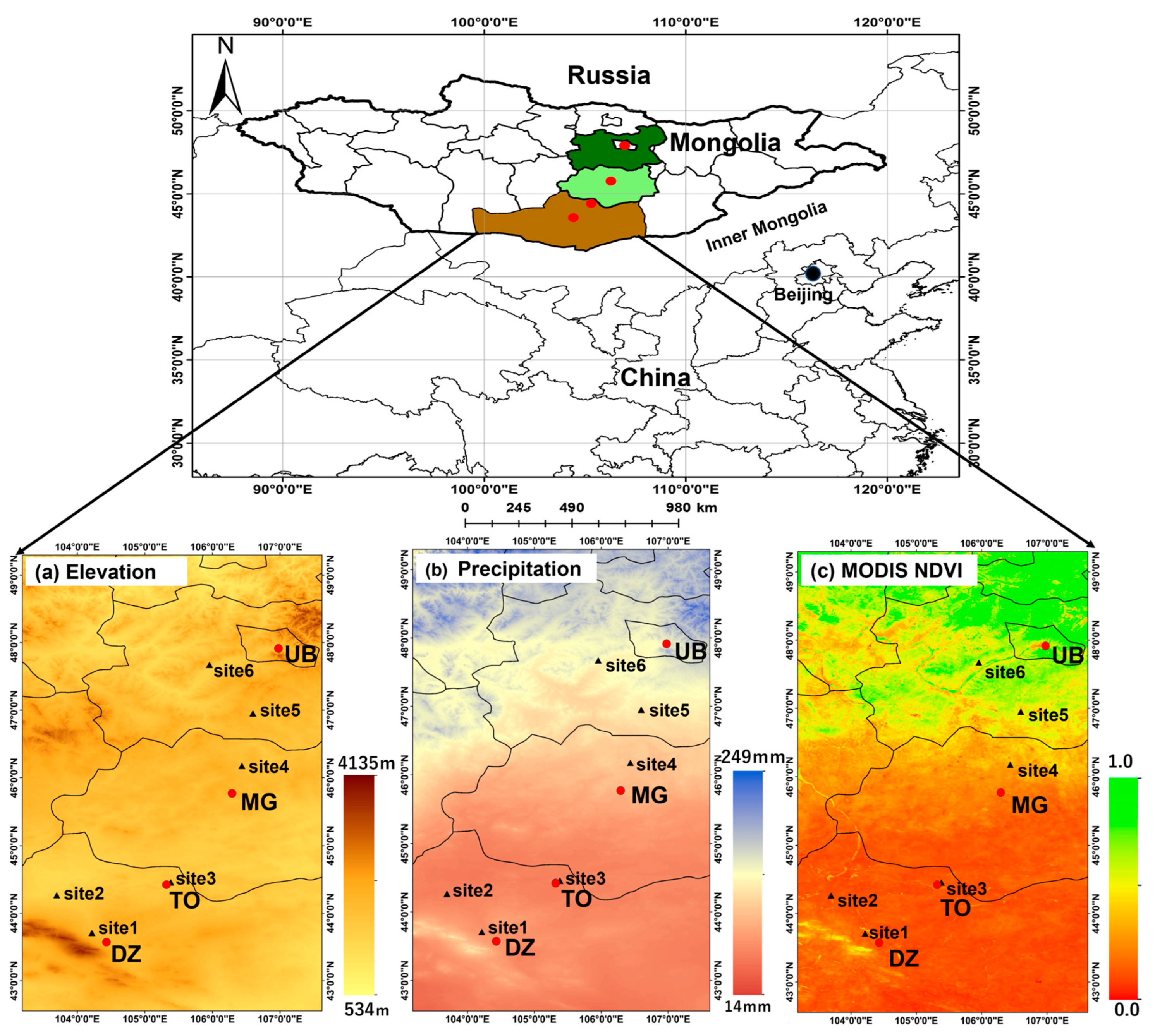
The study area is located in the Mongolian Gobi Desert and steppe region. Mongolia’s geographical coordinates range from 41°35′ to 52°9′N and 87°47′ to 119°56′E, covering an expansive land area of approximately 1,564,000 km2. The average elevation is around 1580 m above sea level, and the annual rainfall averages approximately 200 mm, with significant variations from north to south and east to west. Annual precipitation tends to decrease from the northern to the southern regions, with greater interannual variability in the south compared to the north. Mongolia’s continental climate results in heterogeneous productivity distribution in the steppe [40]. Excluding high mountains and predominantly forested areas in the northern mountains and southern desert regions, roughly 59% of Mongolia’s land area is covered by steppe [41]. This steppe terrain transitions from forest steppe to typical steppe to dry steppe along gradients of precipitation and temperature that vary from north to south, roughly in parallel to latitudinal changes [42]. For this study, we established three sites, ranging from the southern Gobi Desert region to the steppe region in the northern part of Mongolia, each exhibiting varying degrees of aridity. Two distinct locations were selected as study areas based on land use: a steppe region and a Gobi Desert region. As shown in Figure 2, Sites 1, 2, and 3 were located in the Gobi Desert region, while Sites 4, 5, and 6 were in the steppe region. The Gobi Desert is characterized by relatively flat terrain, and the area is known for its sparse vegetation and bare soil.

2.2. Methodology

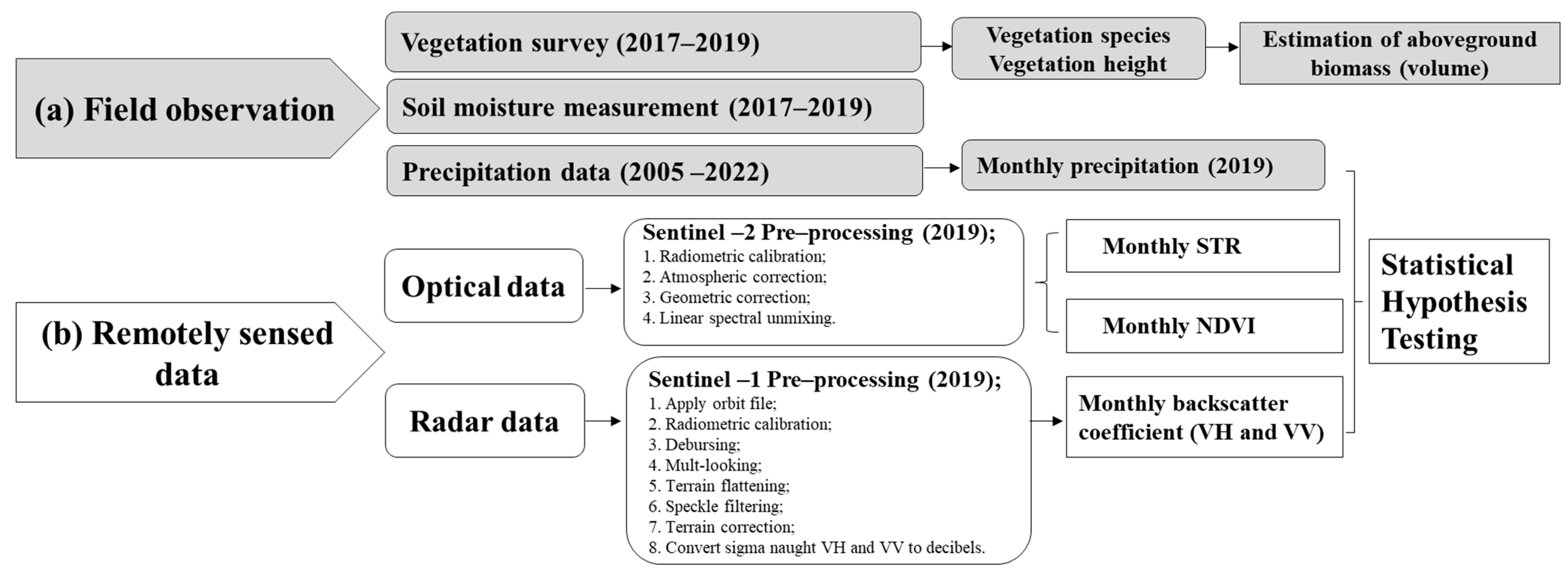
The ground truth data are vital for validating the information derived from satellite data, making it crucial to integrate satellite data analysis with field surveys. Therefore, the methodology for this study comprised two main components: field observation and remote sensing analysis (Figure 3).

2.2.1. Field Observation

Four field vegetation surveys were conducted in August 2017, April 2018, April 2019, and August 2019, covering both the spring germination period and the summer growing period. There were a total of six sites, which were distributed across the region from the Gobi Desert in southern Mongolia to the steppe region in the north. Based on annual precipitation, three (250 × 250) square meter sites were selected in each of the Gobi Desert and steppe regions using GPS positioning. Then, five more plots (10 m × 10 m) were randomly placed within the six sites. Due to the sparse vegetation in the Gobi Desert region, it is difficult to accurately investigate the vegetation distribution by setting a plot smaller than (10 m × 10 m) as the spatial resolution of Sentinel-2 images is 10 m; thus, better integration of remotely sensed imagery with field observation data could be achieved. In each plot, photographs of the entire roped-off plot (10 m × 10 m) were taken from the top of a 2 m survey ladder to visually record the percentage of bare ground and plant cover in order to identify plant community species, as well as to measure plant height and soil moisture, and plant height and vegetation cover were used to estimate the plant volume. In addition, the precipitation data of the study sites for the period of 2005–2022 were downloaded from the Unified Database of Statistics of the National Statistical Commission of Mongolia (http://1212.mn (accessed on 1 August 2019)).

2.2.2. Remote Sensing

For the satellite data analysis, pixel decomposition was performed on Sentinel-2 imagery (August 2019) using the linear spectral unmixing method to calculate the unmixed spatial fraction of vegetation endmember in the mixed pixels of the study site. Correlation analysis was then performed between the NDVI calculated from the original pixels for Sentinel-2 (August 2019) and the field measurements of vegetation coverage (August 2019). In addition, the monthly (Jan–Dec) Normalized Difference Vegetation Index (NDVI), Shortwave Infrared Transformed Reflectance (STR), and backscatter coefficients (σ0VV and σ0VH) were calculated for the study site using 2019 Sentinel-2 and Sentinel-1 imagery. Then, statistical hypothesis testing methods were used to test the correlation of the monthly NDVI, monthly STR, and monthly precipitation with the monthly backscatter coefficients (σ0VV and σ0VH) and with each other. The Sentinel-1/Sentinel-2 imagery used in this study were retrieved from the ESA Copernicus Open Access Hub (https://scihub.copernicus.eu/ (accessed on 1 August 2017)).
  • Optical Data
(1)
Linear Spectral Unmixing
The reflectance of the various ground objects (or endmembers) was mixed together to form the reflectance of the pixels in the satellite image. It can be assumed that the reflectance of each endmember was linearly mixed. If the reflectance of a mixed pixel in a satellite image was M(λ), the spatial fraction of the reflectance of each endmember that composed this mixed pixel can be expressed by the following Equation (1) [43,44]:
M λ = i = 1 N P i × R i ( λ ) ,
where M(λ) is the reflectance of the mixed pixel, Pi is the spatial fraction covered by the ith endmember, Ri(λ) is the reflectance of the ith endmember, N is the number of endmembers in the pixel, and λ is the band.
In this study, the spectral unmixing analysis of mixed pixels was performed using Sentinel-2 satellite data. Three pure pixel endmembers, “vegetation”, “bare land”, and “water area” were selected in the study area; the mixed pixel was decomposed to extract the unmixed spatial fraction of the vegetation endmember; and an analysis was conducted on the correlation between the NDVI calculated from the original pixels of Sentinel-2 and the field measurement of vegetation coverage (%).
(2)
Shortwave Infrared Transformed Reflectance (STR)
A physical model wherein the soil moisture content and STR (SWIR (Short Wave-Infrared Reflectance) Transformed Reflectance) show a linear relationship was created by Sadeghi et al. [22] based on the two-flux radiative transfer model of Kubelka and Munk [45]. The STR is calculated by the following Equation (2):
S T R = ( 1 R S W I R ) 2 2 R S W I R ,
where STR is the SWIR-transformed reflectance and RSWIR is the surface reflectance of shortwave infrared. In areas with little vegetation, the STR is positively correlated with soil moisture.
  • Radar Data
(1)
Microwave backscatter coefficient
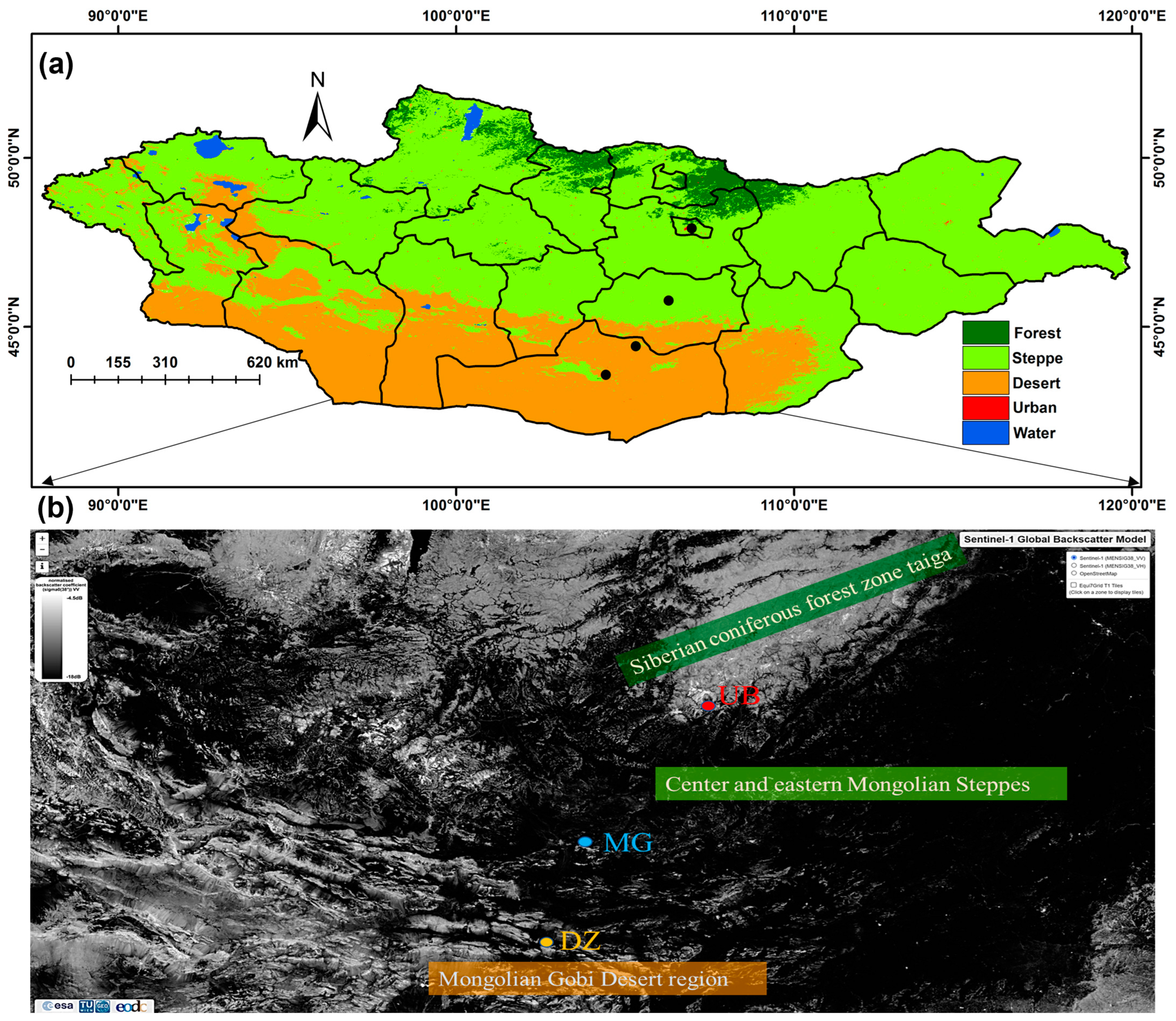
Figure 4a shows the subsets of Mongolian land cover from the global land cover data (2019). Based on the MCD12Q1.061 MODIS Land Cover Type Yearly Global 500 m data [46], the land cover types were reclassified to the three major Mongolian land cover types: desert steppe, steppe, and forest steppe. Figure 4b shows a measured surface backscatter image of Mongolia downloaded from ESA’s Copernicus Sentinel-1 Global Backscatter Model (S1GBM) product, which is a Sentinel-1 IW GRDH that has been normalized to a reference incidence angle of 38°. It is a product that was generated for the period of 2016–2017 and describes the C-band radar cross section of the Earth’s surface. The spatial distribution of the backscatter coefficients showed that the Mongolian land surface is forested in the north, and the forests are dominated by backscatter due to the complex scattering caused by tree trunks and other factors. The central and eastern parts of the country are gently rolling steppe areas with a low backscatter coefficient in the C-band radar, and it is black on the radar image. In the southern Gobi Desert region, locally high C-band backscatter coefficients occur due to exposed microtopography such as rocks, and it is white on the radar image. The spatial resolution of the S1GBM was approximately 20 m × 23 m and includes dual polarization backscatter data for VV (vertical–vertical) and VH (vertical–horizontal) polarization [29], but only the VV polarization image was used in Figure 4b. The data were multilocked and projected onto a WGS 84 ellipsoid with 10 m ground sampling (dB range: −5.0 to −30.0). The Sentinel-1 mission, operated by the European Space Agency (ESA), has a spatial resolution of (5 m × 20 m), whereas the IWS (Interferometric Wide Swath) is 250 km. The EWS (Extra Wide Swath) is 400 km and includes C-band imaging operating in the following four imaging modes: Strip map (SM); Interferometric Wide Swath (IW); Extra Wide Swath (EW); and Wave (WV).
The backscatter coefficient is a crucial observable in radar observations of land, providing a wealth of information about the land surface because it depends on radar-wave reflectance characteristics, such as snow, vegetation, soil moisture, and surface roughness. In this study, the use of microwave satellite Sentinel-1 backscatter coefficients was incorporated to determine land surface conditions (e.g., surface roughness and soil moisture) in arid regions. In this study, the microwave backscatter coefficient (σ0) was computed using the C-band dual-polarized (σ0VV and σ0VH) Sentinel-1 SAR sensor to assess vegetation (surface roughness) and soil moisture conditions across the study sites, ranging from the Gobi Desert region in southern Mongolia to the steppe region in the north. Statistical hypothesis testing methods were used to verify and calculate the correlation coefficients of the backscatter coefficient with the NDVI and STR, as well as with precipitation (Figure 3). The Sentinel-1 descending orbit and incidence near angle was 30.7 degrees and the incidence far angle was 46.27 degrees.
The basic principle of soil moisture estimation by SAR is based on the phenomenon that the strength of the received signal (backscatter coefficient) increases as soil moisture increases. However, backscatter is affected by the unevenness of the ground surface, i.e., surface roughness, so it is necessary to take surface roughness into account and quantify the extent to which reflection and scattering occur and in what direction. Such a procedure is very simple and useful but, under natural conditions, surface roughness varies incrementally, and the spatial distribution is not uniform. Therefore, it is practically difficult to estimate the soil moisture over a wide area, which is one of the major advantages of remote sensing. Nevertheless, in arid regions, the soil is very dry, and the reflection and scattering from the ground surface would be largely unaffected by soil moisture. It has also been reported that the effect of surface roughness on backscatter is greater with lower soil moisture content [47].
Due to the fact that the dielectric properties of soil vary greatly with moisture content, a measurement method has been proposed to estimate the soil moisture from changes in the scattering intensity to a microwave scatter meter [48]. However, it has also been reported that, as the angle of incidence increases, the volumetric moisture content of deep soil becomes worse than that of shallow soil in terms of both the sensitivity and correlation coefficients. In this study, using Sentinel-1 C band satellite data with descending orbit, an incidence near angle of 30.7 degrees, and an incidence far angle of 46.27 degrees, the angle of incidence was set as the angle between the direction vector of the microwaves emitted from the SAR satellite and the normal vector of the terrain. If the object is flat, the off-nadir angle can be used as is, but for curved or inclined surfaces such as the earth’s surface, it must be corrected. The Gobi Desert region of Mongolia does not have a flat ground surface. Therefore, various corrections were made to take into account the topography and other factors. In addition, because it is an extremely arid inland area, the soil moisture content ranges from 2% to 5%, and the topsoil contains very little moisture. The microwave scattering there is mostly due to rocks, dry grass, and microtopography.
The backscatter coefficient, measured as the intensity of microwaves transmitted from the antenna of a microwave satellite and scattered by the ground surface back toward the antenna, depends on the characteristics of the incident wave, as determined by the sensor system, including frequency, polarization, and angle of incidence. The backscatter coefficient depends on the dielectric constant, and the target depends on the characteristics of the observed target, such as the internal inhomogeneity of the medium, surface roughness, etc. Due to this interaction, it is not easy to estimate the physical quantities because of the complex interplay of many influences and the nonlinear relationship with the backscatter coefficient [49]. However, the problem of how to take into account the three factors of soil moisture, surface roughness, and vegetation when using SAR to estimate soil moisture at the ground surface remains the same. If the target site is a bare ground surface, the backscatter coefficient measured by SAR depends mainly on two parameters. These are surface roughness and surface permittivity, where surface permittivity depends on soil moisture. To estimate soil moisture, the effect of surface roughness must be removed, which is not easy to do from single-parameter SAR data (constant frequency, angle of incidence, and polarization) in the absence of known information on roughness. Furthermore, when vegetation is taken into account, the microwave scattering process becomes more complex, making soil moisture estimation more difficult. The following Equation (3) is a scattering model for a typical densely vegetated area [49]. The radar backscatter coefficient (σ0) from the tree canopy is expressed as the sum of contributions including volume scatter (σ0veg) in the canopy, surface scatter (σ0soil) from the ground, and multiple interactions involving both the canopy and the ground surface (σ0soil + veg) [50,51].
σ 0 = σ v e g 0 + σ v e g + s o i l 0 + τ 2 σ s o i l 0
where τ2 is the two-way vegetation transmissivity; the first term represents the scattering due to the vegetation canopy including tree branches and trunks; the second term represents the interaction of some of the scattering from the vegetation canopy with the scattering from the underlying ground; and the third term represents the scattering from the soil layer.

3. Results

3.1. In Situ Investigation Results of the Seasonal Variations of Plant Height, Volume, and Soil Moisture in Two Different Study Regions

In the on-site vegetation survey results, as shown in Figure 5, the mean values of the plant height in the Gobi Desert sites were slightly higher than in the steppe sites. Thus, the Gobi Desert sites had slightly higher plant volumes than the steppe sites in spring. However, during the summer, the vegetation cover of the steppe region was usually higher than the Gobi Desert sites, so the volumes were also higher than the Gobi Desert sites. Due to summer rainfall, the mean values of the soil moisture in the Gobi Desert sites were slightly higher than in the spring. However, in the steppe sites, soil moisture fluctuated to a greater extent, and the mean value was slightly higher than the Gobi Desert sites in summer. Thus, the seasonal variation in land surface parameters such as plant heights, plant volumes, and soil moisture were different between the Gobi Desert and steppe regions.
As shown in Figure 6, in the steppe regions (such as UB and MG), where annual precipitation was more than 150 mm, the penetration of precipitation into the soil in annual plant areas was significantly higher, and the plants were distributed more densely, thus forming a “green carpet” or gap pattern. However, in the Gobi Desert region (such as DZ and TO) where the annual precipitation was 150 mm or less, the perennial plants were sparsely distributed in dotted or striped patterns across bare land. The spatial distribution pattern of the vegetation was largely different in the Gobi Desert and steppe regions.

3.2. Spectral Unmixing the Spatial Fraction Coverage of the Vegetation Endmembers

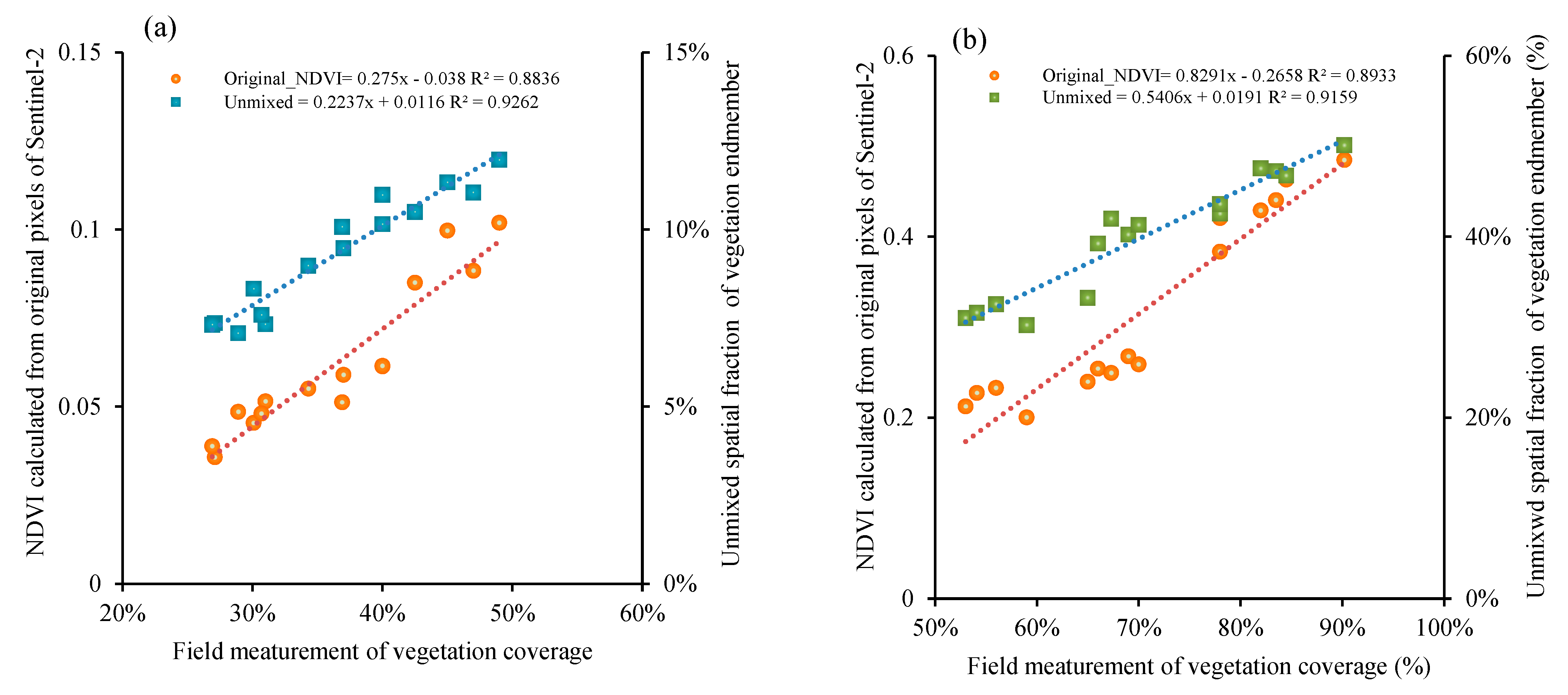
The correlation between the unmixed spatial fraction of the vegetation endmember and NDVI were calculated from the original pixels for Sentinel-2 satellite image (August 2019, i.e., the same time as the field study), as well as field measurements of the vegetation coverage, as shown in Figure 7a,b. The left-hand vertical axis shows the NDVI, which was calculated from the original pixels of Sentinel-2, and the right hand shows the unmixed spatial fraction of the vegetation endmember at the same pixels. The horizontal axis shows the field measurement of vegetation coverage (%) in the quadrat (10 m × 10 m) at the same location.
The results in Figure 7a revealed that, in the Gobi Desert sites, the NDVI that was calculated from the original pixels of Sentinel-2 was lower than that of the unmixed spatial fraction of the vegetation endmember. However, both values were significantly lower than the field measurement of vegetation coverage. In the Gobi Desert sites, there is variation from site to site, and, when the field measurement of vegetation coverage is below 40%, the NDVI calculated from the Sentinel-2 original pixels is less than 0.06, and the site appears sandy in the satellite image. However, when the vegetation coverage on the ground reaches 50%, the NDVI value calculated from the satellite data is greater than 0.1. When the field measurement of vegetation coverage is 30%, the plant component of the unmixing is about twice as large as the satellite NDVI value. This phenomenon indicates that the reflectance of the background soil (sandy) is much higher than that of the vegetation. Figure 7b result revealed that, in steppe sites, when the field measurement of vegetation coverage is 78%, the plant component of unmixing is about 1.1 times less than the satellite NDVI value. In this case, the unmixed spatial fraction of the vegetation endmember and NDVI calculated from the original pixels of Sentinel-2 gradually approached each other. In other words, it was difficult to correctly assess the distribution of plants in the arid regions using only optical satellite sensors. Therefore, in this study, we opted to evaluate the distribution characteristics of the ground objects using data from both optical and microwave satellite sensors.

3.3. Seasonal Variations of the Land Surface of the Two Different Land Cover Study Regions

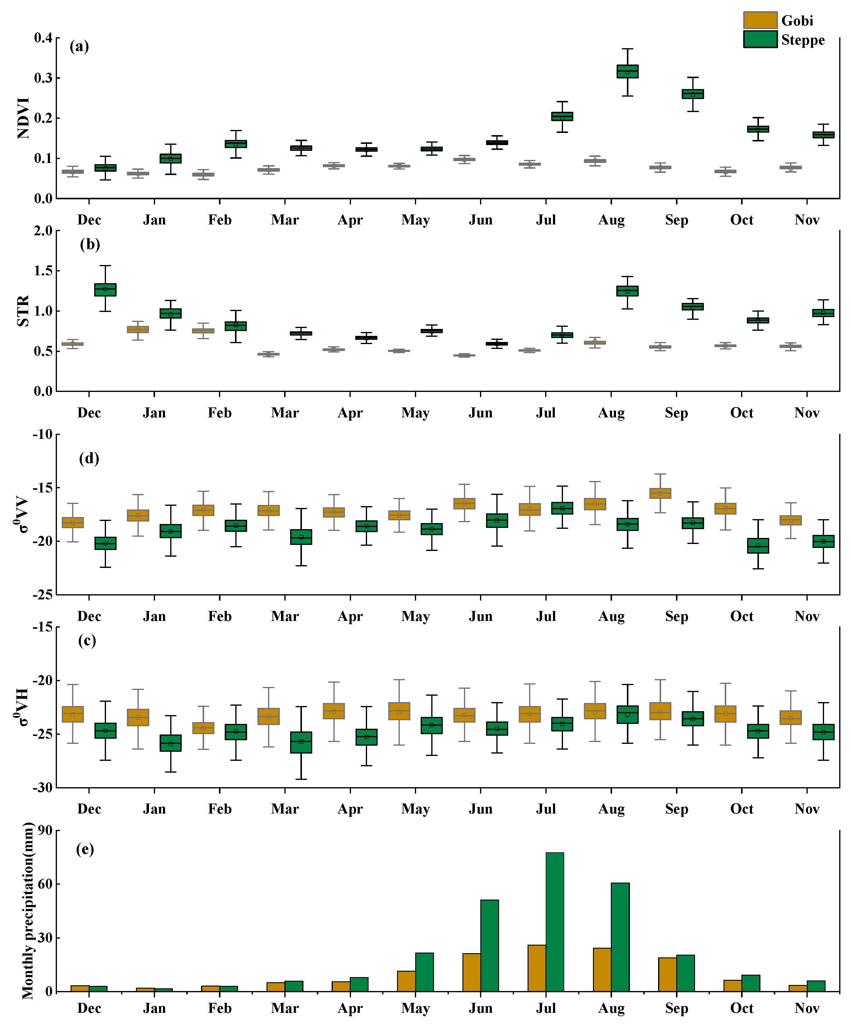
Considering the respective advantages of the optical and microwave satellite data in obtaining land surface information, this study retrieved and compared the seasonal dynamics of the land surface in the Gobi Desert and steppe regions using multisource data (SAR data, optical data, and measured data). Figure 8 shows the monthly mean NDVI, soil moisture, backscatter coefficient (σ0VH and σ0VV), and monthly precipitation in the Gobi Desert and steppe regions for 2019. The Gobi Desert is a dry area with low precipitation and sparse vegetation. Figure 8a,b show minimal seasonal variation in the NDVI and STR. Figure 8c indicates that the σ0VH and σ0VV in the Gobi Desert region were slightly higher than in the steppe region, with σ0VH remaining relatively stable across seasons. However, σ0VV fluctuated slightly, though not significantly, during summer and fall. It can be concluded that the σ0VV is likely more sensitive to seasonal variations in surface conditions than the σ0VH in regions with dry and sparse vegetation. The differences in the mean values were about −6 dB for both σ0VH and σ0VV.
However, there was relatively significant seasonal variation in the NDVI and STR in the steppe region, peaking in August during the month of maximum precipitation. There were also notable seasonal variations in the σ0VH and σ0VV during the summer growing season, with differences in mean values of about −5.6 dB for both coefficients. STR (soil moisture) was relatively high in winter (Dec–Feb), and spring arrived earlier than usual due to the recent warming of the Mongolian climate. This earlier season resulted in increased surface soil moisture due to the melting of snow and permafrost.

3.4. Seasonal Dynamics of the NDVI and Backscatter Coefficients (σ0VH and σ0VV)

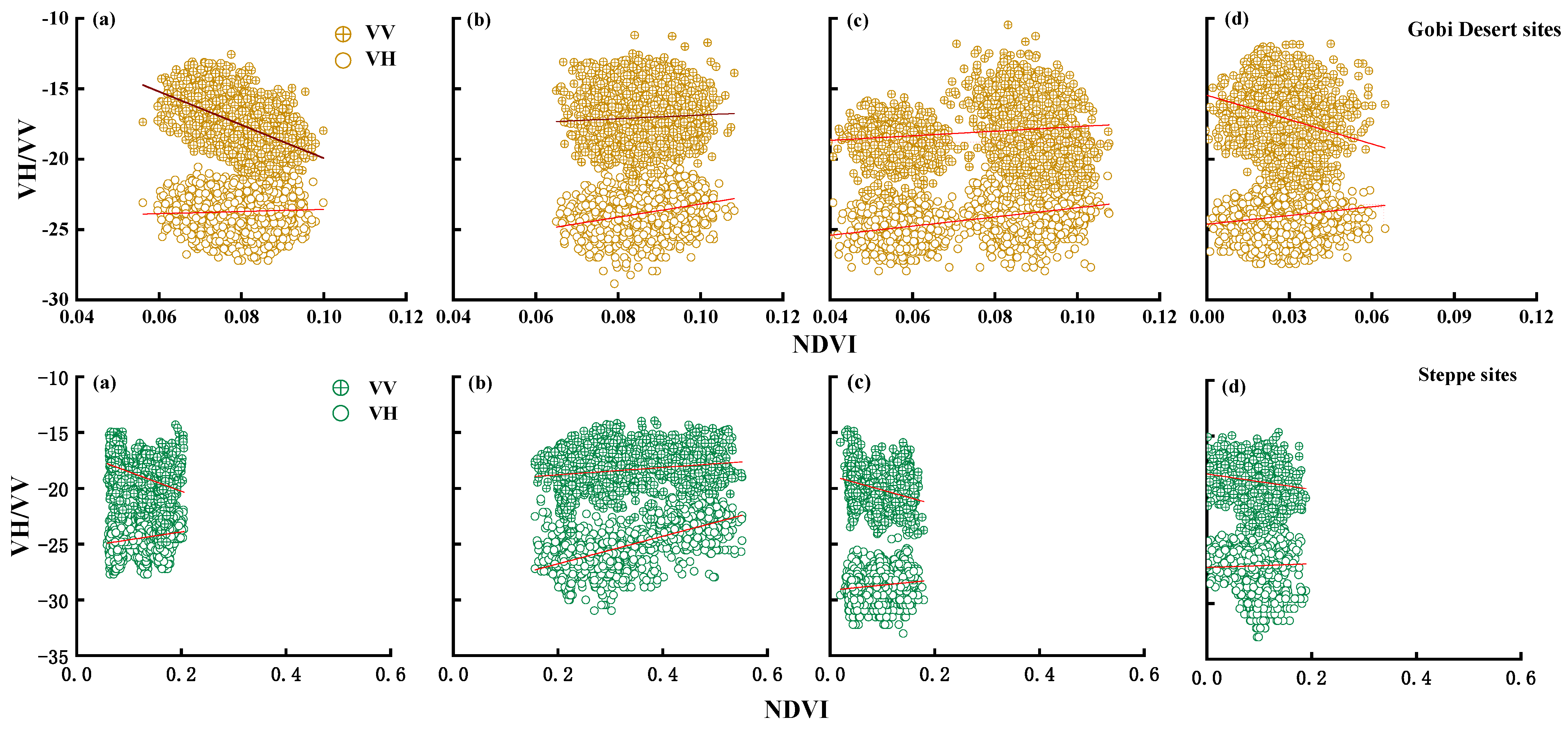
The relationships between σ0VV, σ0VH, the NDVI, and STR reflected the different seasonal dynamics of the land surface. These trends across seasons can be further explored through linear regression in two different study regions. This study examined the relationships between σ0VV, σ0VH, the NDVI, and STR during four distinct periods: early vegetation growth, summer growth, the vegetation senescence in fall, and the winter snow cover period. These correlations are influenced by factors such as vegetation, soil moisture, and vegetation growth status. Figure 9 presents the results of the hypothesis testing for the correlation between the NDVI and σ0VH and σ0VV (Table 1). During the expansion phase in spring, when the vegetation begins to recover and the Gobi Desert land surface is dry with sparse vegetation, there was a low correlation between the NDVI and σ0VH (RVH = 0.05, p < 0.01), and there was also an inverse correlation with σ0VV (RVV= −0.56, p < 0.001). In the summer growth period, the NDVI showed a positive correlation with both σ0VH and σ0VV, with the strongest correlation being observed with σ0VH (RVH = 0.29, RVV = 0.0.06, p < 0.001). During the vegetation senescence in fall, the correlation between the NDVI and σ0VH and σ0VV increased (RVH = 0.44, RVV = 0.14, p < 0.001). In the winter snow period, there was a low correlation between the NDVI and σ0VH (RVH = 0.13, p < 0.001) and an inverse correlation with σ0VV (RVV = −0.23, p < 0.001). In the steppe region, a positive correlation between the NDVI and σ0VH was observed throughout all seasons, with the strongest correlation in summer (RVH = 0.71, p < 0.001), and an inverse correlation was found with σ0VV except in summer (RVV = 0.24, p < 0.001).

3.5. Seasonal Dynamics of STR and the Backscatter Coefficients (σ0VH and σ0VV)

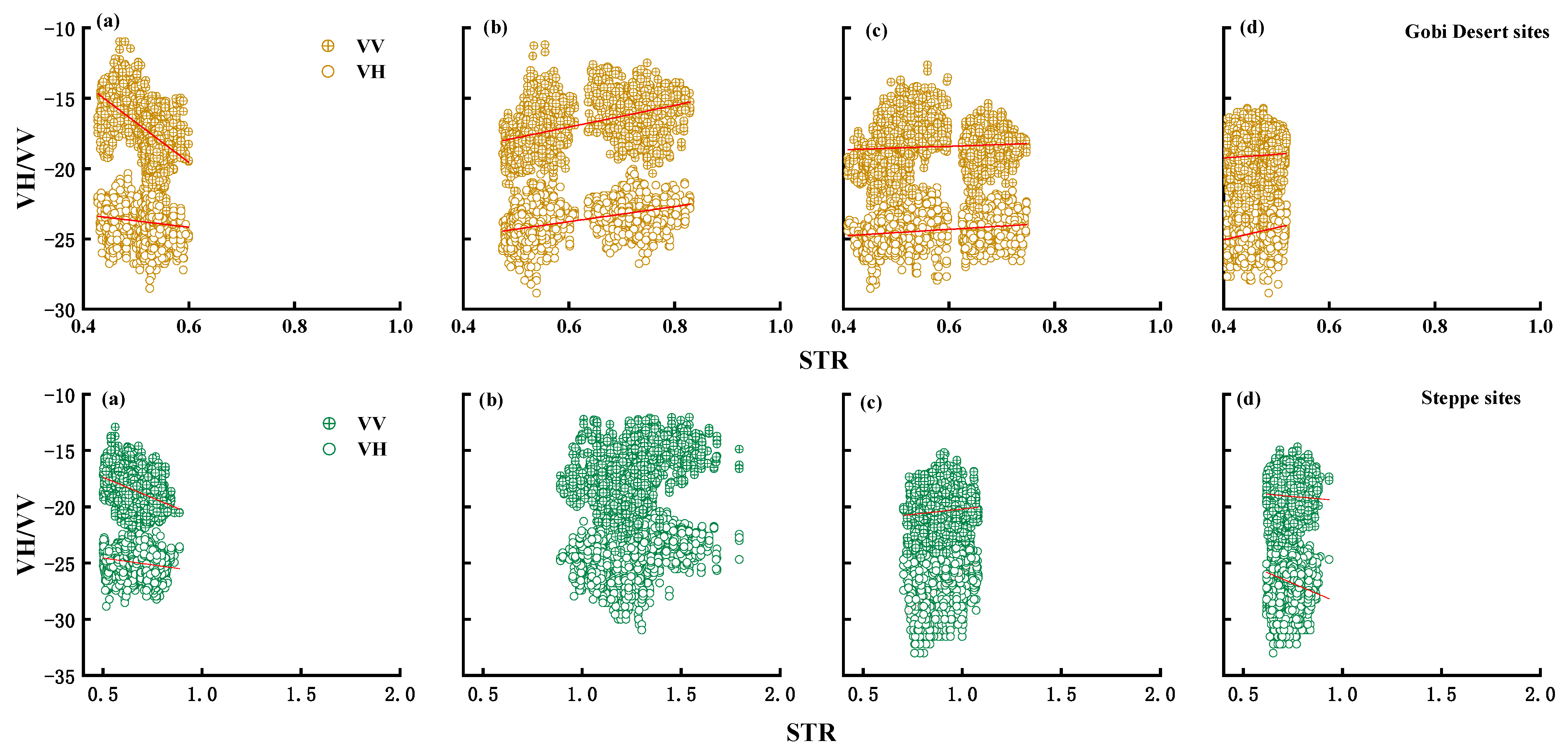
The above results indicate a correlation between σ0VH, σ0VV, and the NDVI during the vegetation growing season. The next question worth exploring is the relationship between the backscatter coefficients and soil moisture. Theoretically, an increase in soil moisture should result in an increase in backscatter coefficients, indicating a positive correlation. However, in this study, there was no correlation between the field-measured soil moisture and backscatter coefficients at both the steppe and Gobi Desert sites. Consequently, we investigated the relationship between the backscatter coefficients and STR, which was calculated using the two-flux radiative transfer model. Figure 10 and Table 1 show positive correlations between STR and σ0VH and σ0VV in all seasons except spring, with the highest correlation in summer found in the Gobi Desert region (RVH = 0.71, p < 0.001). There were positive correlations between STR (soil moisture) and σ0VH and σ0VV in summer (RVH = 0.4, RVV = 0.39, p < 0.001) and fall (RVH = 0.38, RVV = 0.1, p < 0.001), and inverse correlations were found in spring (RVH = −0.17, RVV = −0.38, p < 0.001) and winter (RVH = −0.21, RVV = −0.06). A comparative analysis of the soil moisture inversion methods for different seasons and different polarizations led to the following conclusions: it is fundamental to check the σ0VV and soil moisture relationship when retrieving the soil moisture information from microwave satellite data, especially in areas characterized by sparse vegetation and arid conditions.
In order to determine the effect of the precipitation on land surface conditions, we analyzed the correlation of precipitation with the NDVI, STR, σ0VH, σ0VV, and their seasonal variation. As shown in Table 2, the results revealed that, in the Gobi Desert sites, there was low correlation of precipitation with the NDVI and STR (R = 0.2, R = 0.08, p > 0.05). Conversely, there was a significant correlation between the precipitation and NDVI in the steppe sites (R = 0.72, p < 0.01), although low significant correlation was observed with STR (p = 0.08, p > 0.05). Given the influence of precipitation on the NDVI and soil moisture, we also examined the relationship between the precipitation and the backscatter coefficients. Table 2 illustrates the differing responses of the seasonal variation of backscatter coefficients to precipitation in the Gobi Desert and steppe sites. As presented in Table 2, there was a relatively high correlation of the σ0VH with precipitation (RVH = 0.51, p < 0.01) and a low correlation of the σ0VV (RVV = 0.14, p > 0.05) in the Gobi Desert sites. However, there was high positive correlation of the σ0VH and σ0VV with precipitation in the steppe sites (RVH = 0.61, RVV = 0.51, p < 0.01). Nevertheless, there was no direct causal relationship between precipitation and the backscatter coefficients. We believe that precipitation stimulates vegetation growth and affects the scattering from the land surface.

4. Discussion

4.1. Gobi Desert Region

The Gobi Desert region is very poor in vegetation due to low precipitation and an abundance of sand on the land surface. Research by Natsagdorj et al. [52] has shown that the Gobi Desert experiences a high frequency of DSS and has been a significant source of dust in recent decades. In this region, accurately determining the distribution of plants scattered across sand dunes using optical sensor data is extremely difficult because the reflectance of the desert surface is much higher than that of plants. Consequently, the smaller seasonal variations in the Gobi Desert region and the NDVI calculated from optical satellite data differs significantly from actual plant distributions [19]. In the Gobi Desert sites, there is variation from site to site, and when the field measurement of vegetation coverage is below 40%, the NDVI calculated from the Sentinel-2 original pixels is less than 0.06, and the site appears sandy in the satellite image. However, when the vegetation coverage on the ground reaches 50%, the NDVI value calculated from the satellite data is greater than 0.1. When the field measurement of vegetation coverage is 30%, the plant component of unmixing is about two times less than the satellite NDVI value. Also, in the steppe sites, when the field measurement of vegetation coverage is 78%, the plant component of unmixing is about 1.1 times less than the satellite NDVI value. In this case, the unmixed spatial fraction of vegetation endmembers and the NDVI calculated from the original pixels of Sentinel-2 gradually approach each other. Our study was able to interpret the reasons why the NDVI values calculated from original satellite data in arid and semi-arid regions do not agree with field measurements shown in previous studies [53,54,55]. In addition, an inverse correlation was found between the NDVI and σ0VV in spring and winter in the Gobi Desert region as it is an extremely arid environment (Table 1) and because when plants die in the Gobi Desert regions, they no longer photosynthesize, which is reflected as surface roughness in the backscatter coefficient σ0VV but not in the NDVI value. This is the reason why inverse correlations are common. This phenomenon is particularly noticeable in the Gobi Desert region.
Soil moisture is an important parameter that is mainly affected by precipitation and evaporation [56,57]. Figure 8b shows the smaller seasonal variations in the soil moisture in the Gobi Desert sites. Additionally, from the analysis of the relationship between σ0VH, σ0VV, and STR (soil moisture) in the Gobi Desert region, a positive correlation between STR and both σ0VH and σ0VV was found; the notable exception was in spring, which showed a high inverse correlation instead. The inverse correlation could be due to the effect of dry vegetation. The area with non-green vegetation could have high backscatter compared with the area with low and flat grassland [58]. Even when there is rainfall in the Gobi Desert region, the rapid evaporation and penetration of soil moisture causes the surface to quickly return to a dry state. In an arid environment, soil moisture can be considered constant, and the land surface backscatter intensity over flat and arid areas is primarily influenced by surface roughness [59]. Therefore, in the Gobi Desert region, the changes in the backscatter coefficients primarily reflect the spatial distribution of the land surface roughness elements, including vegetation, gravel, and microtopography [60,61]. Perennial plants in this region have deep roots, allowing them to efficiently draw water from the arid and exposed soil, thereby ensuring their survival [62]. There is a time lag between precipitation and vegetation [19]. However, the NDVI and STR are positively correlated with the backscatter coefficient in summer and fall, indicating that during these seasons, soil moisture and vegetation cover increase simultaneously, suggesting that vegetation in the desert is more abundant in the summer and fall.
Recent studies also have indicated that, in dry sediments and hyper-arid soils, it is difficult to estimate the near-surface soil moisture using the Sentinel-1 C-band backscatter coefficient due to an inverse relationship between the backscatter coefficient and STR. This result aligns with findings from Wagner et al. [63] and Roos et al. [64]. These studies suggest that the inverse correlation is due to variations in soil roughness and could be attributed to volumetric scattering caused by subsurface scatter [65,66,67]. This characteristic is particularly relevant in extremely dry environments like the Gobi Desert, where the surface layers consist of fairly smooth sediments, and the lower layers are characterized by buried uneven gravels [63]. In such dry conditions in spring, microwaves can penetrate the surface layer, causing scattering primarily in the lower layers. As humidity increases, attenuation in the surface layer also increases, reducing the contribution of the backscatter from the buried layer, thus ultimately weakening the signal with increasing surface layer humidity [63,67].
In the Gobi Desert region, the vegetation mainly consists of perennial plants, particularly shrubs like Haloxylon ammodendron, and a small number of annual plants such as Suaeda aralocaspica, which is a common monoecious annual species in the Gobi Desert region [19]. In spring, this vegetation appears as dry grass, which does not show clearly in optical satellite data but can increase land surface roughness, leading to increased backscatter scattering. Summer rainfall stimulates the growth of annual herbaceous plants, and their biomass (dry matter productivity) was recorded in that season. In the following spring, this vegetation existed as dry grass [27,68,69]. The results of this study suggest that dry grass may also play a role in the observed correlations. Optical and microwave images have differing sensitivities to vegetation, with optical sensors being more sensitive to leaves, while microwave sensors are more sensitive to branches [70,71].

4.2. Steppe Region

Compared to the Gobi Desert region, the steppe region exhibited significant seasonal variations in the NDVI, STR, σ0VH, and σ0VV. A positive correlation between the NDVI and σ0VH was observed in all seasons in the steppe region, with the largest correlation occurring in summer. However, the NDVI and σ0VV showed inverse correlations except in the summer season. The results show that the VH polarization was cross polarized, meaning that it also interfered with the steppe plants more than VV polarization. VH polarization showed higher sensitivity to vegetation growth and changes in surface roughness, especially in the steppe region during summer as the VV polarization did not interfere much with the steppe plants. In addition, the NDVI and STR were negatively correlated with the σ0VV in spring, fall, and winter, indicating that, in these seasons, increased soil moisture may lead to sparser vegetation, particularly in the spring. The increase in soil moisture and its mismatch with vegetation growth may be due to the growth cycle of steppe plants and spring snowmelt. On the other hand, in steppe regions, photosynthetic annual herbaceous plants show constant values such as the NDVI, but they are not counted as roughness.
The NDVI and STR showed a strong positive correlation with the backscatter coefficients (σ0VH and σ0VV) in summer, indicating that the vegetation in the steppe was at its most abundant, with soil moisture and vegetation cover being highly consistent. Although the correlation slightly decreased in fall, it still showed a positive relationship, indicating that soil moisture continues to have a significant impact on vegetation cover in the fall. Kasischke et al. [72] found a positive correlation between the backscatter coefficient and soil moisture in areas dominated by herbaceous vegetation cover, a result that is consistent with our study. In this study, STR (soil moisture) was relatively high in summer and winter. Summer precipitation increased soil moisture, which was preserved through the soil freezing due to cold winter on to the spring. In the following spring, the permafrost melted as temperatures rose, providing wet surface conditions [10]. When the soil surface is moist, microwave signals are more likely to penetrate the surface and be absorbed by the soil, resulting in a lower backscatter coefficient and leading to an inverse correlation [73].
The positive correlation between precipitation and σ0VH and σ0VV was due to the strong response of the plants to precipitation in the steppe regions as the precipitation stimulated vegetation growth and consequently interfered with microwaves [19,74]. In the steppe region, which is dominated by annual herbaceous plants, vegetation growth is largely dependent on climatic factors such as precipitation [75,76]. However, there is no direct causal relationship between precipitation and the backscatter coefficients. We believe that precipitation stimulates vegetation growth and affects the scattering from the land surface. In this study, the steppe exhibited stronger correlations between the NDVI and backscatter, particularly in the summer when the vegetation growth was most robust. In winter and spring, increased soil moisture led to a smoother surface, reducing backscatter, while, in fall, the gradual decline in vegetation corresponded with a slight decrease in backscatter.

4.3. Summary

The backscatter coefficients effectively reflected the relationship between soil moisture and vegetation cover across different seasons, particularly in arid or semi-arid regions such as the Gobi Desert. This method can be used to monitor the seasonal variations in soil moisture and vegetation. In regions with higher vegetation cover, such as the steppe, the positive correlation between the backscatter coefficient and vegetation indices suggests that it can serve as a robust tool for assessing vegetation growth and health.
Previous studies have shown that differences in vegetation cover types, as well as soil composition and texture, can affect the penetration capacity of the SAR signal [65]. The radar backscatter coefficient is the result of the combined scattering from soil moisture and vegetation, leading to significant differences between signals from vegetated and bare surfaces. Dabrowska-Zielinska et al. [77] demonstrated that vegetation contributes differently under dry (SM < 30%) and wet conditions (SM > 60%). In the steppe region, where soil moisture is high, vegetation attenuates the SAR signal as it penetrates the vegetation to reach the soil. However, in the extremely dry Gobi Desert, the effect of vegetation is more pronounced than that of soil moisture. Vegetation leaves and branches cause multiple scattering, complicating the propagation path of the radar signal and attenuating the scattered signal [78,79]. Consequently, high vegetation cover reduces the strength of the backscatter signal from soil moisture, affecting the inversion and monitoring of soil moisture using SAR data. Human activities, such as overgrazing, may have altered the soil structure, impacting the backscatter signal [80]. In sparsely vegetated or bare surface regions, the interaction between soil moisture and the backscatter coefficient has been studied, while, in the vegetated surfaces of the steppe region, the focus is on extracting land cover information from the radar backscatter coefficient [81,82].
As the availability of new remote sensing data sources increases, the choice of data sets that can be included in a data integration becomes increasingly broad. Until now, it has been difficult to determine the exact distribution of plants scattered across sandy soil using only optical sensor data. In the steppe region, annual grasses are distributed like a “green carpet,” but these plants are not counted as “ground roughness” in the SAR data. Conversely, in the Gobi Desert region, perennial shrubs dot the sandy soil but are not counted as the NDVI because they have few green leaves, and they are counted largely as “ground roughness”. In this sense, the results obtained in this study can significantly contribute to an accurate assessment of the ground surface conditions in the world’s arid and semi-arid regions where vegetation is scarce.

5. Conclusions

(1)
Due to the high reflectivity of the background soil in the Gobi Desert region, there is a bias between the NDVI from optical images and the actual vegetation. As a result, vegetation does not show up accurately in the NDVI, leading to less seasonal variation. However, σ0VH and σ0VV fluctuate slightly during summer and fall. In contrast, the steppe region shows significant seasonal variation in both the NDVI and STR, with the seasonal variation of σ0VV being more pronounced than that of σ0VH.
(2)
The correlations between the backscatter coefficient and the NDVI and STR vary with the seasons. The inverse correlation between the NDVI and backscatter coefficient (σ0VV) in spring and winter is because, in the Gobi Desert region, perennial shrubs are not photosynthetic, which is reflected as surface roughness in the backscatter coefficient (σ0VV) not in the NDVI value. Additionally, due to the effect of dry vegetation, the area with non-green vegetation could have high backscatter compared with the area with low and flat grassland. On the other hand, in steppe regions, photosynthetic annual herbaceous plants show constant NDVI values but are not counted as roughness.
(3)
This study demonstrates that a combination of optical and microwave satellite data can effectively retrieve the seasonal dynamics of the land surface in arid regions. Through the temporal and spatial analysis of data from the four seasons in the steppe and Gobi Desert regions, the impacts of soil moisture and growing vegetation on backscatter, as well as the changing trends of vegetation and soil moisture in different seasons, can be observed. Future work will focus on further improving the algorithm, enhancing the precision and accuracy of data analysis, as well as providing more reliable data support for drought monitoring and response.

Author Contributions

Y.T. and B.H.: research plan and design, field work, data curation, software, validation, and writing—original draft. K.A., C.M., T.S. and M.P.: review and editing and writing. K.H., K.O., C.L. and S.H.: Writing, review and editing, field validation, and software and data curation. All authors have read and agreed to the published version of the manuscript.

Funding

This research was supported by JSPS KAKENHI Grant-in-Aid for Scientific Research (B) (Grant Numbers (JP) 19H04362.The project title is “Risk assessment of the regional impact of the China "One-Belt-One-Road" (OBOR) project”).

Data Availability Statement

Data will be made available on request.

Acknowledgments

The authors would like to thank the many research students and professors who contributed to this study, including Hairi Han, Kazuaki Araki, and Khew Ee Hung. We would also like to thank all the Mongolian counterparts who assisted us in our field research, as well as all the members of the Hoshino Lab of RGU.

Conflicts of Interest

The authors declare that they have no known competing financial interests or personal relationships that could have appeared to influence the work reported in this paper.

References

  1. Gholizadeh, H.; Zoghipour, M.H.; Torshizi, M.; Nazari, M.R.; Moradkhani, N. Gone with the wind: Impact of soil-dust storms on farm income. Ecol. Econ. 2021, 188, 107133. [Google Scholar] [CrossRef]
  2. Abbasi, S.; Rezaei, M.; Ahmadi, F.; Turner, A. Atmospheric transport of microplastics during a dust storm. Chemosphere 2022, 292, 133456. [Google Scholar] [CrossRef]
  3. Meng, Q.; Yan, C.; Li, R.; Zhang, T.; Zheng, M.; Liu, Y.; Zhang, M.; Wang, G.; Du, Y.; Shang, C. Variations of PM2.5-bound elements and their associated effects during long-distance transport of dust storms: Insights from multi-sites observations. Sci. Total Environ. 2023, 889, 164062. [Google Scholar] [CrossRef] [PubMed]
  4. Guan, Q.; Yang, J.; Zhao, S.; Pan, B.; Liu, C.; Zhang, D.; Wu, T. Climatological analysis of dust storms in the area surrounding the Tengger Desert during 1960–2007. Clim. Dyn. 2015, 45, 903–913. [Google Scholar] [CrossRef]
  5. Tsedendamba, P.; Dulam, J.; Baba, K.; Hagiwara, K.; Noda, J.; Kawai, K.; Sumiya, G.; McCarthy, C.; Kai, K.; Hoshino, B. Northeast Asian dust transport: A case study of a dust storm event from 28 March to 2 April 2012. Atmosphere 2019, 10, 69. [Google Scholar] [CrossRef]
  6. Hagiwara, K.; Matsumoto, T.; Tsedendamba, P.; Baba, K.; Hoshino, B. Bacterial characteristics of dust particle saltation in Gobi dust sites, Mongolia. Atmosphere 2021, 12, 1456. [Google Scholar] [CrossRef]
  7. Wang, S.; Yu, Y.; Zhang, X.X.; Lu, H.; Zhang, X.Y.; Xu, Z. Weakened dust activity over China and Mongolia from 2001 to 2020 associated with climate change and land-use management. Environ. Res. Lett. 2021, 16, 124056. [Google Scholar] [CrossRef]
  8. Liu, H.; Tian, Y.; Ding, D. Contributions of different land cover types in Otindag Sandy Land and Bashang area of Hebei Province to the material source of sand stormy weather in Beijing. Chin. Sci. Bull. 2003, 48, 1853–1856. [Google Scholar] [CrossRef]
  9. Singer, A.; Zobeck, T.; Poberezsky, L.; Argaman, E. The PM10 and PM2.5 dust generation potential of soils/sediments in the Southern Aral Sea Basin, Uzbekistan. J. Arid Environ. 2003, 54, 705–728. [Google Scholar] [CrossRef]
  10. Wu, J.; Kurosaki, Y.; Shinoda, M.; Kai, K. Regional characteristics of recent dust occurrence and its controlling factors in East Asia. Sola 2016, 12, 187–191. [Google Scholar] [CrossRef]
  11. Han, L.; Tsunekawa, A.; Tsubo, M. Effect of frozen ground on dust outbreaks in spring on the eastern Mongolian Plateau. Geomorphology 2011, 129, 412–416. [Google Scholar] [CrossRef]
  12. Kurosaki, Y. Seasonal and regional characteristics of dust event in the Taklimakan Desert. J. Arid Land Stud. 2002, 11, 245–252. [Google Scholar]
  13. Kurosaki, Y.; Mikami, M. Threshold wind speed for dust emission in east Asia and its seasonal variations. J. Geophys. Res. Atmos. 2007, 112, D17202. [Google Scholar] [CrossRef]
  14. Ginoux, P.; Prospero, J.M.; Gill, T.E.; Hsu, N.C.; Zhao, M. Global-scale attribution of anthropogenic and natural dust sources and their emission rates based on MODIS Deep Blue aerosol products. Rev. Geophys. 2012, 50, RG3005. [Google Scholar] [CrossRef]
  15. Wu, C.; Lin, Z.; Liu, X. The global dust cycle and uncertainty in CMIP5 (Coupled Model Intercomparison Project phase 5) models. Atmos. Chem. Phys. 2020, 20, 10401–10425. [Google Scholar] [CrossRef]
  16. Demura, Y.; Hoshino, B.; Sofue, Y.; Kai, K.; Purevsuren, T.; Baba, K.; Noda, J. Estimates of ground surface characteristics for outbreaks of the Asian Dust Storms in the sources region. ProScience 2016, 3, 21–30. [Google Scholar]
  17. Uno, I.; Amano, H.; Emori, S.; Kinoshita, K.; Matsui, I.; Sugimoto, N. Trans-Pacific yellow sand transport observed in April 1998: A numerical simulation. J. Geophys. Res. Atmos. 2001, 106, 18331–18344. [Google Scholar] [CrossRef]
  18. Pettorelli, N.; Vik, J.O.; Mysterud, A.; Gaillard, J.-M.; Tucker, C.J.; Stenseth, N.C. Using the satellite-derived NDVI to assess ecological responses to environmental change. Trends Ecol. Evol. 2005, 20, 503–510. [Google Scholar] [CrossRef]
  19. Sofue, Y.; Hoshino, B.; Demura, Y.; Kai, K.; Baba, K.; Nduati, E.; Kondoh, A.; Sternberg, T. Satellite monitoring of vegetation response to precipitation and dust storm outbreaks in Gobi Desert regions. Land 2018, 7, 19. [Google Scholar] [CrossRef]
  20. Reiche, J.; Verbesselt, J.; Hoekman, D.; Herold, M. Fusing Landsat and SAR time series to detect deforestation in the tropics. Remote Sens. Environ. 2015, 156, 276–293. [Google Scholar] [CrossRef]
  21. Zhang, N.; Hong, Y.; Qin, Q.M.; Liu, L. VSDI: A visible and shortwave infrared drought index for monitoring soil and vegetation moisture based on optical remote sensing. Int. J. Remote Sens. 2013, 34, 4585–4609. [Google Scholar] [CrossRef]
  22. Sadeghi, M.; Jones, S.B.; Philpot, W.D. A linear physically-based model for remote sensing of soil moisture using short wave infrared bands. Remote Sens. Environ. 2015, 164, 66–76. [Google Scholar] [CrossRef]
  23. Barrett, B.W.; Dwyer, E.; Whelan, P. Soil Moisture Retrieval from Active Spaceborne Microwave Observations: An Evaluation of Current Techniques. Remote Sens. 2009, 1, 210–242. [Google Scholar] [CrossRef]
  24. Beriaux, E.; Lucau-Danila, C.; Auquiere, E.; Defourny, P. Multiyear independent validation of the water cloud model for retrieving maize leaf area index from SAR time series. Int. J. Remote Sens. 2013, 34, 4156–4181. [Google Scholar] [CrossRef]
  25. Gaber, A.; Soliman, F.; Koch, M.; El-Baz, F. Using full-polarimetric SAR data to characterize the surface sediments in desert areas: A case study in El-Gallaba Plain, Egypt. Remote Sens. Environ. 2015, 162, 11–28. [Google Scholar] [CrossRef]
  26. Ullmann, T.; Stauch, G. Surface roughness estimation in the orog nuur basin (Southern mongolia) using sentinel-1 SAR time series and ground-based photogrammetry. Remote Sens. 2020, 12, 3200. [Google Scholar] [CrossRef]
  27. Buyantogtokh, B.; Kurosaki, Y.; Tsunekawa, A.; Tsubo, M.; Ishizuka, M.; Gantsetseg, B.; Batjargal, G. Estimating the sand saltation thresholds from Sentinel-1 SAR data in the Gobi Desert, Mongolia. J. Arid Environ. 2022, 202, 104772. [Google Scholar] [CrossRef]
  28. Ulaby, F.T.; Dubois, P.C.; Van Zyl, J. Radar mapping of surface soil moisture. J. Hydrol. 1996, 184, 57–84. [Google Scholar] [CrossRef]
  29. Bauer-Marschallinger, B.; Cao, S.; Navacchi, C.; Freeman, V.; Reuß, F.; Geudtner, D.; Rommen, B.; Vega, F.C.; Snoeij, P.; Attema, E. The normalised Sentinel-1 Global Backscatter Model, mapping Earth’s land surface with C-band microwaves. Sci. Data 2021, 8, 1–18. [Google Scholar] [CrossRef]
  30. Zhang, B.; Wdowinski, S.; Gann, D.; Hong, S.H.; Sah, J. Spatiotemporal variations of wetland backscatter: The role of water depth and vegetation characteristics in Sentinel-1 dual-polarization SAR observations. Remote Sens. Environ. 2022, 270, 112864. [Google Scholar] [CrossRef]
  31. Imhoff, M.L. Radar Backscatter and Biomass Saturation: Ramifications for Global Biomass Inventory. IEEE Trans. Geosci. Remote Sens. 1995, 33, 51–518. [Google Scholar] [CrossRef]
  32. Ma, J.; Zhang, W.; Marinoni, A.; Gao, L.; Zhang, B. An Improved Spatial and Temporal Reflectance Unmixing Model to Synthesize Time Series of Landsat-Like Images. Remote Sens. 2018, 10, 1388. [Google Scholar] [CrossRef]
  33. Zhu, X.; Cai, F.; Tian, J.; Williams, T.K. Spatiotemporal Fusion of Multisource Remote Sensing Data: Literature Survey, Taxonomy, Principles, Applications, and Future Directions. Remote Sens. 2018, 10, 527. [Google Scholar] [CrossRef]
  34. Setiyono, T.; Quicho, E.; Gatti, L.; Campos-Taberner, M.; Busetto, L.; Collivignarelli, F.; García-Haro, F.J.; Boschetti, M.; Khan, N.I.; Holecz, F. Spatial Rice Yield Estimation Based on MODIS and Sentinel-1 SAR Data and ORYZA CropGrowth Model. Remote Sens. 2018, 10, 293. [Google Scholar] [CrossRef]
  35. Zhang, L.; Zhang, Z.; Lu, S.; Xiang, D.; Su, Y. Fast Superpixel-Based Non-Window CFAR Ship Detector for SAR Imagery. Remote Sens. 2022, 14, 2092. [Google Scholar] [CrossRef]
  36. Valdivieso-Ros, C.; Alonso-Sarria, F.; Gomariz-Castillo, F. Effect of the Synergetic Use of Sentinel-1, Sentinel-2, LiDAR and Derived Data in Land Cover Classification of a Semiarid Mediterranean Area Using Machine Learning Algorithms. Remote Sens. 2023, 15, 312. [Google Scholar] [CrossRef]
  37. Cuypers, S.; Nascetti, A.; Vergauwen, M. Land Use and Land Cover Mapping with VHR and Multi-Temporal Sentinel-2 Imagery. Remote Sens. 2023, 15, 2501. [Google Scholar] [CrossRef]
  38. Zhang, G.; Roslan, S.N.A.; Wang, C.; Quan, L. Research on land cover classifcation of multi-source remote sensing data based on improved U-net network. Sci. Rep. 2023, 13, 16275. [Google Scholar]
  39. Xiang, Y.; Tian, X.; Xu, Y.; Guan, X.; Chen, Z. EGMT-CD: Edge-Guided Multimodal Transformers Change Detection from Satellite and Aerial Images. Remote Sens. 2024, 16, 86. [Google Scholar] [CrossRef]
  40. Batima, P.; Natsagdorj, L.; Gombluudev, P.; Erdenetsetseg, B. Observed Climate Change in Mongolia. AIACC Work. Pap. 2005, 12, 1–26. [Google Scholar]
  41. Hao, J.; Lin, Q.; Wu, T.; Chen, J.; Li, W.; Wu, X.; Hu, G.; La, Y. Spatial–Temporal and Driving Factors of Land Use/Cover Change in Mongolia from 1990 to 2021. Remote Sens. 2023, 15, 1813. [Google Scholar] [CrossRef]
  42. Vandandorj, S.; Gantsetseg, B.; Boldgiv, B. Spatial and temporal variability in vegetation cover of Mongolia and its implications. J. Arid Land 2015, 7, 450–461. [Google Scholar] [CrossRef]
  43. Garini, Y.; Young, I.T.; McNamara, G. Spectral imaging: Principles and applications. Cytom. J. Int. Soc. Anal. 2006, 69, 735–747. [Google Scholar] [CrossRef] [PubMed]
  44. Hoshino, B.; Tian, Y.; Shima, K.; Riga, S.; Enkhtuvshin, Z.; McCarthy, C.; Purevtseren, M. Remotely Sensed Method for Detection of Spatial Distribution Pattern of Dryland Plants in Water Limited Ecosystem. In Proceedings of the IGARSS 2020–2020 IEEE International Geoscience and Remote Sensing Symposium, Waikoloa, HI, USA, 26 September–2 October 2020; pp. 2799–2802. [Google Scholar]
  45. Kubelka, P.; Munk, F. An article on optics of paint layers. Fuer Tekn. Physik. 1931, 12, 593–609. [Google Scholar]
  46. MCD12Q1.061 MODIS Land Cover Type Yearly Global 500m: NASA LP DAAC at the USGS EROS Center. Available online: https://developers.google.com/earth-engine/datasets/catalog/MODIS_061_MCD12Q1 (accessed on 1 April 2024).
  47. Chen, F.; Crow, W.T.; Bindlish, R.; Colliander, A.; Burgin, M.S.; Asanuma, J.; Aida, K. Global-scale evaluation of SMAP, SMOS and ASCAT soil moisture products using triple collocation. Remote Sens. Environ. 2018, 214, 1–13. [Google Scholar] [CrossRef] [PubMed]
  48. Bindlish, R.; Barros, A.P. Multifrequency soil moisture inversion from SAR measurements with the use of IEM. Remote Sens. Environ. 2000, 71, 67–88. [Google Scholar] [CrossRef]
  49. Moran, M.S.; Peters-Lidard, C.D.; Watts, J.M.; McElroy, S. Estimating soil moisture at the watershed scale with satellite-based radar and land surface models. Can. J. Remote Sens. 2004, 30, 805–826. [Google Scholar] [CrossRef]
  50. Bindlish, R.; Barros, A.P. Parameterization of vegetation backscatter in radar-based, soil moisture estimation. Remote Sens. Environ. 2001, 76, 130–137. [Google Scholar] [CrossRef]
  51. Hoshino, B.; Yonemori, M.; Manayeva, K.; Karamalla, A.; Yoda, K.; Suliman, M.; Elgamri, M.; Nawata, H.; Mori, Y.; Yabuki, S. Remote sensing methods for the evaluation of the mesquite tree (Prosopis juliflora) environmental adaptation to semi-arid Africa. In Proceedings of the 2011 IEEE International Geoscience and Remote Sensing Symposium, Vancouver, BC, Canada, 24–29 July 2011; pp. 1910–1913. [Google Scholar]
  52. Natsagdorj, L.; Jugder, D.; Chung, Y. Analysis of dust storms observed in Mongolia during 1937–1999. Atmos. Environ. 2003, 37, 1401–1411. [Google Scholar] [CrossRef]
  53. Carlson, T.N.; Ripley, D.A. On the relation between NDVI, fractional vegetation cover, and leaf area index. Remote Sens. Environ. 1997, 62, 241–252. [Google Scholar] [CrossRef]
  54. Glenn, E.; Huete, A.; Nagler, P.L.; Nelson, S.G. Relationship Between Remotely-sensed Vegetation Indices, Canopy Attributes and Plant Physiological Processes: What Vegetation Indices Can and Cannot Tell Us About the Landscape. Sensors 2008, 8, 2136–2160. [Google Scholar] [CrossRef] [PubMed]
  55. Johansen, b.; Tømmervik, H. The relationship between phytomass, NDVI and vegetation communities on Svalbard. Int. J. Appl. Earth Obs. Geoinf. 2014, 27, 20–30. [Google Scholar] [CrossRef]
  56. Shao, Y.; Fraedrich, K.; Ishizuka, M. Modelling soil moisture in hyper-arid conditions. Bound.-Layer Meteorol. 2021, 179, 169–186. [Google Scholar] [CrossRef]
  57. Chen, Z.; Gao, X.; Lei, J. Dust emission and potential diffusion process in Mongolia. Land Degrad. Dev. 2023, 34, 2750–2762. [Google Scholar] [CrossRef]
  58. French, A.N.; Schmugge, T.J.; Ritchie, J.C.; Hsu, A.; Jacob, F.; Ogawa, K. Detecting land cover change at the Jornada Experimental Range, New Mexico with ASTER emissivities. Remote Sens. Environ. 2008, 112, 1730–1748. [Google Scholar] [CrossRef]
  59. Deroin, J.P.; Company, A.; Simonin, A. An empirical model for interpreting the relationship between backscatter and arid land surface roughness as seen with the SAR. IEEE Trans. Geosci. Remote Sens. 1997, 35, 86–92. [Google Scholar] [CrossRef]
  60. Tansey, K.; Millington, A. Investigating the potential for soil moisture and surface roughness monitoring in drylands using ERS SAR data. Int. J. Remote Sens. 2001, 22, 2129–2149. [Google Scholar] [CrossRef]
  61. Collingwood, A.; Treitz, P.; Charbonneau, F. Surface roughness estimation from RADARSAT-2 data in a High Arctic environment. Int. J. Appl. Earth Obs. Geoinf. 2014, 27, 70–80. [Google Scholar] [CrossRef]
  62. Hardenberg, J.; Meron, E.; Shachak, M.; Zarmi, Y. Diversity of vegetation patterns and desertification. Phys. Rev. Lett. 2001, 87, 198101. [Google Scholar] [CrossRef]
  63. Wagner, W.; Lindorfer, R.; Melzer, T.; Hahn, S.; Bauer-Marschallinger, B.; Morrison, K.; Calvet, J.C.; Hobbs, S.; Quast, R.; Greimeister-Pfeil, I. Widespread occurrence of anomalous C-band backscatter signals in arid environments caused by subsurface scattering. Remote Sens. Environ. 2022, 276, 113025. [Google Scholar] [CrossRef]
  64. Roos, S.de.; Busschaert, L.; Lievens, H.; Bechtold, M.; De Lannoy, G.J. Optimisation of AquaCrop backscatter simulations using Sentinel-1 observations. Remote Sens. Environ. 2023, 294, 113621. [Google Scholar] [CrossRef]
  65. Adodo, F.I.; Remy, F.; Picard, G. Seasonal variations of the backscatter coefficient measured by radar altimeters over the Antarctic Ice Sheet. Cryosphere 2018, 12, 1767–1778. [Google Scholar] [CrossRef]
  66. Graldi, G.; Zardi, D.; Vitti, A. Retrieving Soil Moisture at the Field Scale from Sentinel-1 Data over a Semi-Arid Mediterranean Agricultural Area. Remote Sens. 2023, 15, 2997. [Google Scholar] [CrossRef]
  67. Ullmann, T.; Jagdhuber, T.; Hoffmeister, D.; May, S.M.; Baumhauer, R.; Bubenzer, O. Exploring Sentinel-1 backscatter time series over the Atacama Desert (Chile) for seasonal dynamics of surface soil moisture. Remote Sens. Environ. 2023, 285, 113413. [Google Scholar] [CrossRef]
  68. Kurosaki, Y.; Shinoda, M.; Mikami, M. What caused a recent increase in dust outbreaks over East Asia? Geophys. Res. Lett. 2011, 38, L11702. [Google Scholar] [CrossRef]
  69. Wu, J.; Kurosaki, Y.; Sekiyama, T.T.; Maki, T. Effects of Dry Vegetation Coverage Estimated from the MODIS Soil Tillage Index on Dust Occurrence: Verification by Surface Synoptic Observations. J. Meteorol. Soc. Jpn. Ser. II 2023, 101, 67–77. [Google Scholar] [CrossRef]
  70. Enquist, B.J.; Niklas, K.J. Global allocation rules for patterns of biomass partitioning in seed plants. Science 2002, 295, 1517–1520. [Google Scholar] [CrossRef]
  71. West, G.B.; Enquist, B.J.; Brown, J.H. A general quantitative theory of forest structure and dynamics. Proc. Natl. Acad. Sci. USA 2009, 106, 7040–7045. [Google Scholar] [CrossRef]
  72. Kasischke, E.S.; Bourgeau-Chavez, L.L.; Rober, A.R.; Wyatt, K.H.; Waddington, J.M.; Turetsky, M.R. Effects of soil moisture and water depth on ERS SAR backscatter measurements from an Alaskan wetland complex. Remote Sens. Environ. 2009, 113, 1868–1873. [Google Scholar] [CrossRef]
  73. Xu, C.; Qu, J.; Hao, X.; Wu, D. Monitoring Surface Soil Moisture Content over the Vegetated Area by Integrating Optical and SAR Satellite Observations in the Permafrost Region of Tibetan Plateau. Remote Sens. 2020, 12, 183. [Google Scholar] [CrossRef]
  74. Yang, F.; Chongyi, E. Correlation analysis between sand-dust events and meteorological factors in Shapotou, Northern China. Environ. Earth Sci. 2010, 59, 1359–1365. [Google Scholar]
  75. Lee, E.H.; Sohn, B.J. Recent increasing trend in dust frequency over Mongolia and Inner Mongolia regions and its association with climate and surface condition change. Atmos. Environ. 2011, 45, 4611–4616. [Google Scholar] [CrossRef]
  76. Mao, R.; Ho, C.H.; Feng, S.; Gong, D.Y.; Shao, Y. The influence of vegetation variation on Northeast Asian dust activity. Asia Pac. J. Atmos. Sci. 2013, 49, 87–94. [Google Scholar] [CrossRef]
  77. Dabrowska-Zielinska, K.; Musial, J.; Malinska, A.; Budzynska, M.; Gurdak, R.; Kiryla, W.; Bartold, M.; Grzybowski, P. Soil moisture in the Biebrza Wetlands retrieved from Sentinel-1 imagery. Remote Sens. 2018, 10, 1979. [Google Scholar] [CrossRef]
  78. Ulaby, F.T.; van Deventer, T.E.; East, J.R.; Haddock, T.F. Millimeter-wave bistatic scattering from ground andvegetation targets. IEEE Trans. Geosci. Remote Sens. 1988, 26, 229–243. [Google Scholar] [CrossRef]
  79. Townsend, P. Mapping seasonal flooding in forested wetlands using multi-temporal radarsat SAR. Photogramm. Eng. Remote Sens. 2001, 67, 857–864. [Google Scholar]
  80. Tian, Y.; Hai, R.H.; Yong, H.; Myagmartseren, P.; Hoshino, B. Impact of settlement-type grazing on rangeland vegetation in the Inner Mongolia autonomous region: A field verification of case study through a grazing experiment. Agric. Biol. Res. 2023, 39, 537–546. [Google Scholar]
  81. Pope, K.O.; Rey-Benayas, J.M.; Paris, J.F. Radar remote sensing of forest and wetland ecosystems in the Central American tropics. Remote Sens. Environ. 1994, 48, 205–219. [Google Scholar] [CrossRef]
  82. Wagner, W.; Lemoine, G.; Rott, H. A method for estimating soil moisture from ERS scatterometer and soil data. Remote Sens. Environ. 1999, 70, 191–207. [Google Scholar] [CrossRef]
Figure 1. A schematic of the seasonal dust-outbreak patterns (Where, the arrows in the figure indicate the direction of wind).
Remotesensing 16 03143 g001
Figure 2. The study area. Top panel: Mongolian cites of Ulaanbaatar (UB, Tov Province, dark green fill); Mandalgobi (MG, Dundgobi Province, light green fill); Tsogt-Ovoo (TO, Omnogobi Province, brown Fill); and Dalanzadgad (DZ, Omnogobi Province, brown Fill). Bottom panel: (a) elevation; (b) monthly precipitation in August 2019; and (c) the MODIS Maximum NDVI in August 2019 for Gobi Desert sites (1, 2, and 3) and steppe sites (4, 5, and 6).
Remotesensing 16 03143 g002
Figure 3. Flowchart of the research methodology. (a) The field investigation contents, including the meteorological station data (precipitation). (b) The remotely sensed data.
Remotesensing 16 03143 g003
Figure 4. (a) Land cover distribution map of Mongolia in 2019; and (b) Sentinel−1 Global Backscatter Model of Mongolia (Where, light colors indicate high backscatter coefficients and dark colors indicate low backscatter coefficients. © S1GBM ESA). Reprinted/adapted with permission from Ref. [29].
Remotesensing 16 03143 g004
Figure 5. Seasonal variation of the plant height, volume, and soil moisture in the Gobi Desert and steppe sites (the box plots show the mean (square), median (mid−line), first quartile, and third quartile (box edges), as well as the minimum and maximum (whiskers)).
Remotesensing 16 03143 g005
Figure 6. Spatial distribution pattern of the vegetation in Gobi Desert and steppe regions.
Remotesensing 16 03143 g006
Figure 7. The correlation between the field measurement (2019) of vegetation coverage quadrats (10 m × 10 m) and the unmixed spatial fraction of the vegetation endmember and NDVI calculated from original pixels of Sentinel−2 (2019). (a) The Gobi Desert sites and (b) the steppe sites.
Remotesensing 16 03143 g007
Figure 8. (a) The monthly NDVI from Sentinel−2; (b) the monthly STR from Sentinel−2; (c) the monthly σ0VH from Sentinel−1; (d) the monthly σ0VH from Sentinel−1; and (e) the monthly precipitation (2019).
Remotesensing 16 03143 g008
Figure 9. The relationships between the seasonal variation of the NDVI and σ0VV and σ0VH (dB) in the Gobi Desert and steppe sites. (a) Spring (May); (b) summer (August); (c) fall (November); and (d) winter (January) (Where, the top panel of the figure shows the Gobi Desert sites, and the bottom panel shows the Steppe sites; Also. the red lines are 95% Confidence Interval (CI)).
Remotesensing 16 03143 g009
Figure 10. The relationships between the seasonal variation of STR and σ0VH and σ0VV (dB) in the Gobi Desert and steppe sites. (a) Spring (May); (b) summer (August); (c) fall (November); and (d) winter (January) (Where, the top panel of the figure shows the Gobi Desert sites, and the bottom panel shows the Steppe sites; Also. the red lines are 95% Confidence Interval (CI)).
Remotesensing 16 03143 g010
Table 1. Hypothesis test for the correlations between the seasonal variation of σ0VH, σ0VV, the NDVI, and STR in the Gobi Desert and steppe sites.
Backscatter Coefficient (σ0VH and σ0VV) NDVISTR
RVHRVVRVHRVV
Gobi Desert sitesSpring (May)0.05 *−0.56 ***−0.12 ***−0.58 ***
Summer (August)0.29 ***0.06 **0.45 ***0.48 ***
Fall (November)0.44 ***0.14 ***0.19 ***0.08 ***
Winter (January)0.13 ***−0.23 ***0.26 ***0.07 ***
Steppe sitesSpring (May)0.23 ***−0.43 ***−0.17 ***−0.38 ***
Summer (August)0.71 ***0.24 ***0.40 ***0.39 ***
Fall (November)0.16 ***−0.34 ***0.38 ***0.09 ***
Winter (January)0.02−0.13 ***−0.21 ***−0.06 **
Asterisks indicate significance at different levels: * p < 0.05, ** p < 0.01, and *** p < 0.001.
Table 2. The relationship correlations between monthly precipitation and the NDVI and STR in the Gobi Desert and the Steppe sites.
NDVISTRσ0VHσ0VV
RRRR
Precipitation (mm)Gobi Desert sites0.20.080.51 *0.14
Steppe sites0.72 **0.080.61 **0.51 *
Asterisks indicate significance at different levels: * p < 0.05, ** p < 0.01.
Disclaimer/Publisher’s Note: The statements, opinions and data contained in all publications are solely those of the individual author(s) and contributor(s) and not of MDPI and/or the editor(s). MDPI and/or the editor(s) disclaim responsibility for any injury to people or property resulting from any ideas, methods, instructions or products referred to in the content.