

Rapid Spaceborne Mapping of Wildfire Retardant Drops for Active Wildfire Management


Abstract

1. Introduction
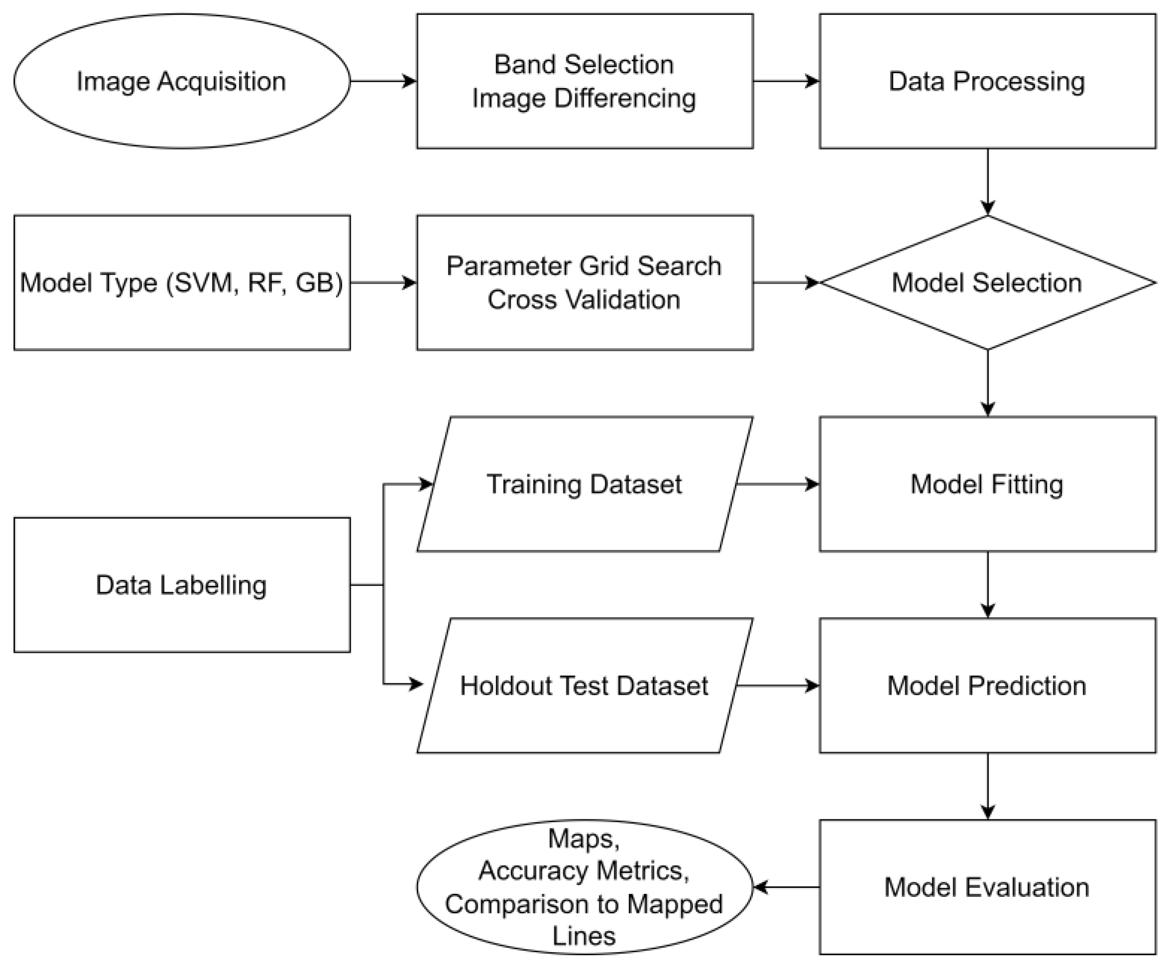
2. Materials and Methods
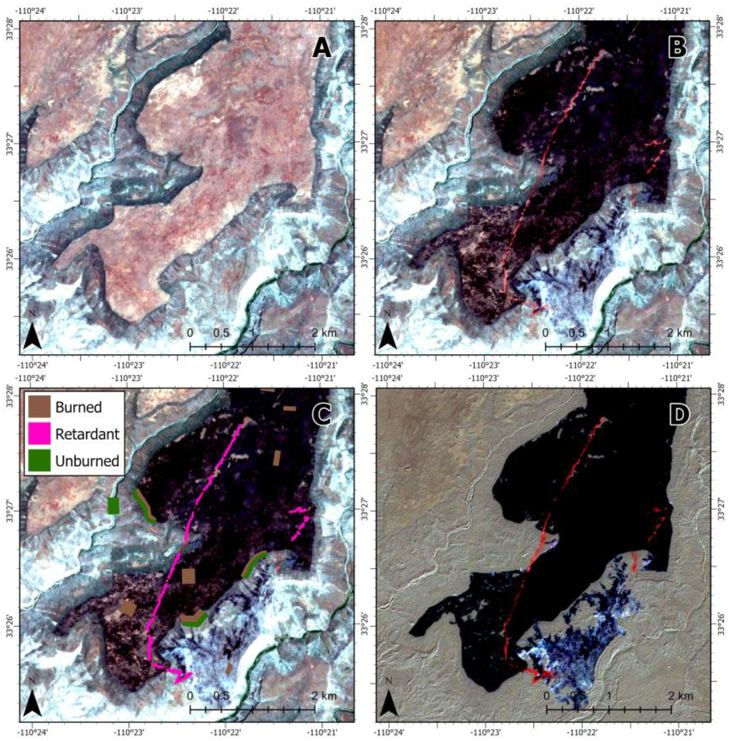
3. Results
4. Discussion
5. Conclusions
Supplementary Materials
Author Contributions
Funding
Data Availability Statement
Acknowledgments
Conflicts of Interest
References
- Stonesifer, C.S.; Calkin, D.E.; Thompson, M.P.; Belval, E.J. Is This Flight Necessary? The Aviation Use Summary (AUS): A Framework for Strategic, Risk-Informed Aviation Decision Support. Forests 2021, 12, 1078. [Google Scholar] [CrossRef]
- Calkin, D.E.; Stonesifer, C.S.; Thompson, M.P.; McHugh, C.W. Large airtanker use and outcomes in suppressing wildland fires in the United States. Int. J. Wildland Fire 2014, 23, 259–271. [Google Scholar] [CrossRef]
- Plucinski, M.P.; Pastor, E. Criteria and methodology for evaluating aerial wildfire suppression. Int. J. Wildland Fire 2013, 22, 1144–1154. [Google Scholar] [CrossRef]
- Giménez, A.; Pastor, E.; Zárate, L.G.; Planas, E.; Arnaldos, J. Long-term forest fire retardants: A review of quality, effectiveness, application and environmental considerations. Int. J. Wildland Fire 2004, 13, 1–15. [Google Scholar] [CrossRef]
- USDA. Nationwide Aerial Application of Fire Retardant on National Forest System Lands; USFS, Ed.; USDA: Washington, DC, USA, 2020.
- USDA. Aerial Firefighting Use and Effectiveness (AFUE) Report; USFS, Ed.; USDA: Washington, DC, USA, 2020.
- Pérez, Y.; Pastor, E.; Planas, E.; Plucinski, M.; Gould, J. Computing forest fires aerial suppression effectiveness by IR monitoring. Fire Saf. J. 2011, 46, 2–8. [Google Scholar] [CrossRef]
- Pastor, E.; Planas, E. Infrared imagery on wildfire research. Some examples of sound capabilities and applications. In Proceedings of the IEEE 2012 3rd International Conference on Image Processing Theory, Tools and Applications (IPTA), Istanbul, Turkey, 15–18 October 2012. [Google Scholar]
- Jazebi, S.; de Leon, F.; Nelson, A. Review of wildfire management techniques—Part I: Causes, prevention, detection, suppression, and data analytics. IEEE Trans. Power Deliv. 2019, 35, 430–439. [Google Scholar] [CrossRef]
- Szpakowski, D.M.; Jensen, J.L. A review of the applications of remote sensing in fire ecology. Remote Sens. 2019, 11, 2638. [Google Scholar] [CrossRef]
- Barmpoutis, P.; Papaioannou, P.; Dimitropoulos, K.; Grammalidis, N. A review on early forest fire detection systems using optical remote sensing. Sensors 2020, 20, 6442. [Google Scholar] [CrossRef] [PubMed]
- Ambrosia, V.; Zajkowski, T.; Quayle, B. Near-Real-Time Earth Observation Data Supporting Wildfire Management. In Proceedings of the 2013 AGU Fall Meeting, San Francisco, CA, USA, 9–13 December 2013. [Google Scholar]
- Allison, R.S.; Johnston, J.M.; Craig, G.; Jennings, S. Airborne optical and thermal remote sensing for wildfire detection and monitoring. Sensors 2016, 16, 1310. [Google Scholar] [CrossRef] [PubMed]
- Wu, Y.; Arapi, A.; Huang, J.; Gross, B.; Moshary, F. Intra-continental wildfire smoke transport and impact on local air quality observed by ground-based and satellite remote sensing in New York City. Atmos. Environ. 2018, 187, 266–281. [Google Scholar] [CrossRef]
- Serra-Burriel, F.; Delicado, P.; Prata, A.T.; Cucchietti, F.M. Estimating heterogeneous wildfire effects using synthetic controls and satellite remote sensing. Remote Sens. Environ. 2021, 265, 112649. [Google Scholar] [CrossRef]
- Chuvieco, E.; Aguado, I.; Salas, J.; García, M.; Yebra, M.; Oliva, P. Satellite remote sensing contributions to wildland fire science and management. Curr. For. Rep. 2020, 6, 81–96. [Google Scholar] [CrossRef]
- Jain, P.; Coogan, S.C.P.; Subramanian, S.G.; Crowley, M.; Taylor, S.W.; Flannigan, M.D. A review of machine learning applications in wildfire science and management. Environ. Rev. 2020, 28, 478–505. [Google Scholar] [CrossRef]
- Lentile, L.B.; Holden, Z.A.; Smith, A.M.S.; Falkowski, M.J.; Hudak, A.T.; Morgan, P.; Lewis, S.A.; Gessler, P.E.; Benson, N.C. Remote sensing techniques to assess active fire characteristics and post-fire effects. Int. J. Wildland Fire 2006, 15, 319–345. [Google Scholar] [CrossRef]
- Coleman, A. Rapid Analytics for Disaster Response—Wildfire (RADR-Fire). In Proceedings of the Tactical Fire Remote Sensing Advisory Committee Meeting, Online, 11–13 May 2021. [Google Scholar]
- Drusch, M.; Del Bello, U.; Carlier, S.; Colin, O.; Fernandez, V.; Gascon, F.; Hoersch, B.; Isola, C.; Laberinti, P.; Martimort, P.; et al. Sentinel-2: ESA’s optical high-resolution mission for GMES operational services. Remote Sens. Environ. 2012, 120, 25–36. [Google Scholar] [CrossRef]
- Maxwell, A.E.; Warner, T.A.; Fang, F. Implementation of machine-learning classification in remote sensing: An applied review. Int. J. Remote Sens. 2018, 39, 2784–2817. [Google Scholar] [CrossRef]
- Sheykhmousa, M.; Mahdianpari, M.; Ghanbari, H.; Mohammadimanesh, F.; Ghamisi, P.; Homayouni, S. Support vector machine versus random forest for remote sensing image classification: A meta-analysis and systematic review. IEEE J. Sel. Top. Appl. Earth Obs. Remote Sens. 2020, 13, 6308–6325. [Google Scholar] [CrossRef]
- Hultquist, C.; Chen, G.; Zhao, K. A comparison of Gaussian process regression, random forests and support vector regression for burn severity assessment in diseased forests. Remote Sens. Lett. 2014, 5, 723–732. [Google Scholar] [CrossRef]
- Saltiel, T.M.; Dennison, P.E.; Campbell, M.J.; Thompson, T.R.; Hambrecht, K.R. Tradeoffs between UAS spatial resolution and accuracy for deep learning semantic segmentation applied to wetland vegetation species mapping. Remote Sens. 2022, 14, 2703. [Google Scholar] [CrossRef]
- Lawrence, R.L.; Moran, C.J. The AmericaView classification methods accuracy comparison project: A rigorous approach for model selection. Remote Sens. Environ. 2015, 170, 115–120. [Google Scholar] [CrossRef]


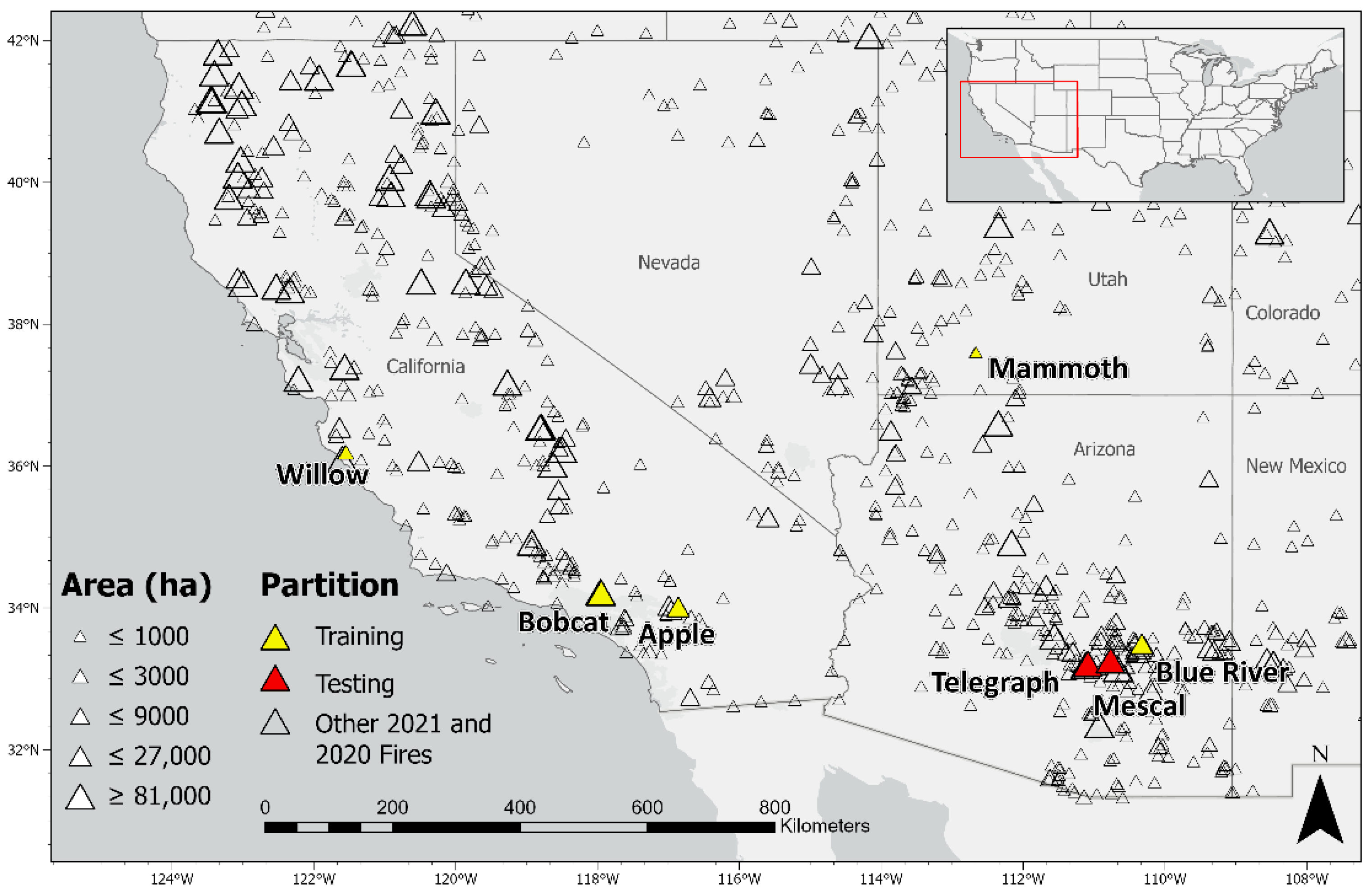
| Incident Name | Year | Fire Start | Fire End | Pre-Image | Post-Image | Location | Size (ha) |
|---|---|---|---|---|---|---|---|
| Apple | 2020 | Jul 31 | Nov 16 | Jul 27 | Aug 08 | Cherry Valley, CA | 13,526 |
| Blue River | 2020 | Jun 05 | Jun 18 | May 29 | Jun 08 | 15 mi NE of San Carlos, AZ | 11,352 |
| Bobcat | 2020 | Sep 06 | Oct 19 | Aug 01 | Sep 20 | Azusa, CA | 46,861 |
| Mammoth | 2021 | Jun 05 | Jun 20 | Jun 01 | Jun 11 | Mammoth Creek, UT | 287 |
| Mescal | 2021 | Jun 01 | Jun 18 | Jun 03 | Jun 13 | Globe, AZ | 29,239 |
| Willow | 2021 | Jun 17 | Jul 11 | Jun 13 | Jun 23 | Arroyo Seco, CA | 1164 |
| Telegraph | 2021 | Jun 04 | Jul 08 | Jun 03 | Jun 13 | Superior, AZ | 73,150 |
| Model | Classification | Imagery | Train Overall Accuracy | Test Overall Accuracy | Test Retardant Precision | Test Retardant Recall | Test Retardant F1 Score |
|---|---|---|---|---|---|---|---|
| RF | Single-class | Difference | 0.928 | 0.949 | 0.998 | 0.544 | 0.705 |
| RF | Single-class | Post-application | 0.935 | 0.916 | 0.996 | 0.253 | 0.404 |
| RF | Multiclass | Difference | 0.809 | 0.873 | 0.997 | 0.589 | 0.74 |
| RF | Multiclass | Post-application | 0.815 | 0.822 | 0.997 | 0.245 | 0.393 |
| SVM | Single-class | Difference | 0.933 | 0.938 | 0.978 | 0.46 | 0.626 |
| SVM | Single-class | Post-application | 0.945 | 0.898 | 0.993 | 0.091 | 0.167 |
| SVM | Multiclass | Difference | 0.812 | 0.912 | 0.99 | 0.549 | 0.706 |
| SVM | Multiclass | Post-application | 0.837 | 0.813 | 0.992 | 0.091 | 0.167 |
| GB | Single-class | Difference | 0.936 | 0.947 | 0.999 | 0.531 | 0.693 |
| GB | Single-class | Post-application | 0.942 | 0.893 | 0.998 | 0.051 | 0.097 |
| GB | Multiclass | Difference | 0.814 | 0.881 | 0.999 | 0.615 | * 0.761 |
| GB | Multiclass | Post-application | 0.825 | 0.8 | 0.998 | 0.052 | 0.1 |
| Class | Precision | Recall | F1 Score |
|---|---|---|---|
| Retardant | 0.999 | 0.615 | 0.761 |
| Burned | 0.803 | 0.999 | 0.890 |
| Unburned | 0.920 | 0.997 | 0.957 |
| Cloud post-application | 0.883 | 0.875 | 0.879 |
| Cloud pre-application | 0.714 | 0.583 | 0.642 |
| Shadow post-application | 0.605 | 0.330 | 0.427 |
| Shadow pre-application | 0.960 | 0.855 | 0.904 |
Disclaimer/Publisher’s Note: The statements, opinions and data contained in all publications are solely those of the individual author(s) and contributor(s) and not of MDPI and/or the editor(s). MDPI and/or the editor(s) disclaim responsibility for any injury to people or property resulting from any ideas, methods, instructions or products referred to in the content. |
© 2023 by the authors. Licensee MDPI, Basel, Switzerland. This article is an open access article distributed under the terms and conditions of the Creative Commons Attribution (CC BY) license (https://creativecommons.org/licenses/by/4.0/).
Share and Cite
Tagestad, J.D.; Saltiel, T.M.; Coleman, A.M. Rapid Spaceborne Mapping of Wildfire Retardant Drops for Active Wildfire Management. Remote Sens. 2023, 15, 342. https://doi.org/10.3390/rs15020342
Tagestad JD, Saltiel TM, Coleman AM. Rapid Spaceborne Mapping of Wildfire Retardant Drops for Active Wildfire Management. Remote Sensing. 2023; 15(2):342. https://doi.org/10.3390/rs15020342
Chicago/Turabian StyleTagestad, Jerry D., Troy M. Saltiel, and André M. Coleman. 2023. "Rapid Spaceborne Mapping of Wildfire Retardant Drops for Active Wildfire Management" Remote Sensing 15, no. 2: 342. https://doi.org/10.3390/rs15020342
APA StyleTagestad, J. D., Saltiel, T. M., & Coleman, A. M. (2023). Rapid Spaceborne Mapping of Wildfire Retardant Drops for Active Wildfire Management. Remote Sensing, 15(2), 342. https://doi.org/10.3390/rs15020342