Article

Spatial and Temporal Variability of Soil Erosion in Northeast China from 2000 to 2020

1
State Key Laboratory of Resources and Environmental Information System, Institute of Geographic Sciences and Natural Resources Research, CAS, Beijing 100101, China
2
University of Chinese Academy of Sciences, Beijing 100049, China
3
Key Laboratory of Land Surface Pattern and Simulation, Institute of Geographic Sciences and Natural Resources Research, CAS, Beijing 100101, China
*
Author to whom correspondence should be addressed.
Remote Sens. 2023, 15(1), 225; https://doi.org/10.3390/rs15010225
Submission received: 24 October 2022 / Revised: 25 December 2022 / Accepted: 28 December 2022 / Published: 31 December 2022

Abstract

:
Northeast China is a prominent base for commercial grain production nationwide. Soil erosion, a primary cause of land degradation and grain yield decrease, has become an imminent issue and is still not well documented in Northeast China. Thus, a comprehensive assessment of soil erosion in Northeast China is essential for deepening our understanding of various geological and agricultural issues, such as control of regional water and soil losses, anti-degeneration attempts on black soil, preservation of land fertility, and safeguarding of national food security. Based on the Revised Universal Soil Loss Equation (RUSLE) and the Revised Wind Erosion Equation (RWEQ) models, this paper comprehensively assessed the water and wind erosion in Northeast China from 2000 to 2020 and analyzed the current situation, as well as the spatial and temporal evolution of soil erosion. The results suggest the following: (1) The degree of soil erosion in Northeast China was mainly slight, and water erosion was more severe than wind erosion. Water and wind erosion in bare land and grassland were more intensive than in cropland and forests. The Liao River Plain (LRP) has undergone relatively intensive water erosion, while the wind erosion in the Greater Kinggan Mountains Region (GKMR) was more intensive than in other sub-regions. (2) A slight intensifying trend of water erosion could be observed in Northeast China from 2000 to 2020, where the area of slight water erosion decreased and that of light and intensive water erosion increased. The water erosion in the Changbai Mountain Region (CBMR), the Sanjiang Plain (SJP), and the Songnen Plain (SNP) intensified, while the LRP has undergone slower water erosion than before. The water erosion in bare land and cropland intensified, while the water erosion in grassland and forests slowed down. Compared to the first decade (2000–2010), the second decade (2010–2020) in the timespan of study had a reversed trend of water erosion from intensifying to moderating, which means water erosion was alleviated. (3) A moderating trend in wind erosion could be found in Northeast China from 2000 to 2020, where the area of slight wind erosion increased and that of light, moderate, and intensive wind erosion decreased. The wind erosion in the LRP showed a pronounced decrease, and the wind erosion in bare land and cropland also considerably decreased. Compared to the first decade, the amount of wind erosion in the second decade decreased by 18.2%, but the rate in the second decade decreased slowly or even increased. These two facts indicate that wind erosion in Northeast China has alleviated, but this trend is gradually slowing down. Soil erosion is caused by multiple factors, such as climate, topography, soil, and human activities. This study provides important implications for our understanding of soil erosion control and management in Northeast China. In sub-regions with severe erosion, such as the LRP and the GKMR, we can adopt methods such as zero tillage, cross ridge tillage, and straw mulching according to the local characteristics of soil erosion to slow down the process.

1. Introduction

Soil erosion is one of the essential processes in physical geography in which soil and its parent material undergo destruction, denudation, transportation, and deposition from natural or anthropogenic erosive forces produced by rain, runoff, wind, gravity, tillage, and other sources [1,2,3]. Soil erosion is a severe global environmental issue that leads to land degradation, soil nutrient loss, non-point source pollution, and increased risk of floods and droughts [4,5,6,7,8]. In particular, soil erosion degrades soil fertility and eventually renders the land unproductive, thus presenting a grave challenge to the sustainable development of agriculture [9,10,11].
Because of its flat terrain and rich black soil, Northeast China has grown into a significant production base for commodity grain and a prominent area for crop production nationwide, contributing to the annual food demand of more than 216 million urban citizens [12,13]. However, soil erosion in the region has been deteriorating the land in recent years, and the disconnection and devouring of farmland caused by the process will eventually threaten food security [14,15,16,17]. For the black soil region in Northeast China, high-intensity continuous cropping has impaired the soil structure, which has then caused multiple issues such as reduced black soil thickness and organic matter content, expansion of erosion area, decreased productivity, and a worsened ecological environment [11]. Severe soil erosion has occurred since the commencement of large-scale cultivation in the 1950s and the average black soil thickness has decreased by 40 cm since then [18,19,20,21]. Previous studies have proposed that the average rate of erosion in this region has reached approximately 15 Mg·ha−1·yr−1 or more [22,23] and that the erosion will consume the black soil within 113 years [24]. Therefore, it is essential to assess water and wind erosion in Northeast China to ensure the sustainable development of agriculture there.
In recent years, the severe soil erosion in Northeast China has caused increasing concern. Several studies have been carried out, including the characterization of hillslope erosion [20,25,26] and gully erosion [12,15,19,27,28,29,30], the impact of soil erosion on SOC, soil productivity and crop production [11,31,32,33,34,35,36], the identification of sediment sources [9,14,22,37,38], factors influencing erosion rates [15,24], gully erosion mapping and monitoring [39,40,41], and the controlling strategies against erosion [13,42,43,44,45]. Most existing studies focus on assessing water erosion in local areas or small watersheds and try to build relationships between the soil erosion rates and various influencing factors. However, there are few studies on water and wind erosion and the spatial and temporal evolution of the process on a large scale in Northeast China.
According to the dominant exogenic process during erosion, researchers divide soil erosion into two types: water erosion and wind erosion [46]. An essay in 2010 suggested that the area affected by severe soil erosion in Northeast China was 275,900 km2, which comprised 27.09% of the total territory. Among the eroded lands, the areas affected by water erosion and wind erosion were 180,000 and 33,600 km2, respectively [47]. The study indicated that water erosion was the main erosion form in the region and has caused the most soil loss there. Previous studies have revealed that the area affected by water erosion is the largest in Northeast China, and severe erosion at intensive or higher levels is often associated with wind erosion [48]. Research on wind erosion nationwide started only recently and currently, authors mainly discuss the issue in arid and semi-arid regions. The wind erosion conditions in Northeast China draw relatively less attention. Northeast China is susceptible to frequent wind hazards, and the loose structure of black soil aggravates wind erosion. Therefore, it is also imperative to study the influencing factors and quantitative relationship behind the wind erosion on the cropland there [49].
Researchers have applied various methods and instruments to estimate soil erosion, such as laboratory simulations [20,26,50,51,52], 137Cs tracers [14,24,37,53], remote sensing interpretation [17,29,39], and Universal Soil Loss Equation/Revised Universal Soil Loss Equation (USLE/RUSLE) models [4,54,55]. The inherent shortcomings of methods such as 137Cs tracers and remote sensing interpretation, such as uncertainty and subjectivity, may affect assessment accuracy. The RUSLE integrates various natural and artificial factors, including rainfall erosivity, soil erodibility, topography, vegetation coverage and management, soil conservation protection, and fits for assessing water erosion at a regional scale [4,56,57]. Various models have also been used in simulating wind erosion, with the Revised Wind Erosion Equation (RWEQ) model being one of the most commonly used models [1,58,59]. The RWEQ model reduces the complexity of wind erosion, but it still covers a wide range of factors such as the effects of wind speed, precipitation, temperature, soil texture, topography, and vegetation cover on wind erosion [60,61,62]. Many scholars have confirmed the accuracy and applicability of the RWEQ model in simulating wind erosion on different terrains, such as plains, valleys, farmland, and grasslands [63]. The RWEQ model has also yielded results in some areas in China at large scales, including the Beijing–Tianjin Sandstorm Source Region [64], the watershed of the Ningxia–Inner Mongolia reaches of the Yellow River [65], the Three-River Headwaters Region [66], Hunshandake Desert [67], and Qinghai Province [68].
In summary, what is the overall macro-scale degree of change in soil erosion in Northeast China over the past 20 years? Which areas and ecosystems are experiencing severer soil erosion? These are urgent questions that we need to address. Along these lines, we try to investigate the changes in water and wind erosion based on the RUSLE and the RWEQ method. These models were selected because they share many common advantages, such as simple modeling processes, fewer input parameters, are suitable for large spatio-temporal scales, and have easy integration with the GIS database [3]. For the models above, we localized all parameters to improve the accuracy of results. The specific objectives of this study are: (1) to quantitatively evaluate the water and wind erosion in Northeast China from 2000 to 2020; (2) to analyze the current situation and the spatial and temporal evolutionary characteristics of water and wind erosion, and reveal the changing patterns of soil erosion among different areas and types of ecosystems in Northeast China from 2000 to 2020; (3) to briefly analyze the factors behind soil erosion and preventive measures against the process, intending to provide a scientific basis for soil erosion control and management in Northeast China.

2. Materials and Methods

2.1. Study Area

Northeast China refers to the region that is located between 115°32′ E to 135°09′ E and 38°42′ N to 53°35′ N. The region encompasses the Heilongjiang (HLJ), Jilin (JL), and Liaoning (LN) provinces, as well as the eastern portion of the Inner Mongolia Autonomous Region (IM) (Figure 1). The land area of Northeast China is approximately 1.25 × 10⁶ km2, accounting for 13% of China’s total area. Most of the study area is characterized by a temperate continental monsoon climate. Over the past 30 years, the average annual air temperature in Northeast China has been 5.68 °C and the average annual precipitation has been 615 mm, with significant variation across the region [48]. This study divided Northeast China into six geographic sub-regions based on the terrain, vegetation, and climate, namely the Greater Kinggan Mountains Region (GKMR), the Lesser Kinggan Mountains Region (LKMR), the Changbai Mountain Region (CBMR), the Sanjiang Plain (SJP), the Songnen Plain (SNP), and the Liao River Plain (LRP). The GKMR and the LKMR are located in the western and the northern parts of the study area, while the CBMR is in the southeastern part of it. The three plains (SJP, SNP, and LRP) form the central part of the study area from north to south [4,69]. Northeast China is a prominent base for commercial grain production nationwide because of its fertile black soil, but high-intensity reclamation has caused severe erosion and degradation of the black soil, as well as severe water and soil losses on slope cropland. The area affected by water and soil losses in the region accounts for about one-fourth of the total land, and the annual yield decrease caused by soil erosion alone can reach 14.7% [70]. Meanwhile, the region also boasts the most extensive natural forests in China, which are indispensable in water conservation, soil conservation, and sand fixation. The forests in Northeast China mainly grow in the GKMR, LKMR, and CBMR. Their forests account for 37% of China’s total forest area, with a timber volume of 3.2 billion cubic meters, equaling one-third of the total timber volume nationwide. Zhang et al. [71] found that although the multi-year soil erosion in Northeast China has generally been moderating, the gully erosion has been increasing due to human activities. Furthermore, soil erosion in this area may worsen with future climate change.

2.2. Data

The data adopted in the study include land use/cover change (LUCC) data, normalized difference vegetation index (NDVI) data, meteorological observation data, digital elevation model (DEM) data, and soil data.
LUCC datasets in 2000, 2010, and 2020 were obtained from the Resource and Environment Science and Data Center (https://www.resdc.cn (accessed on 1 August 2022)) and were generated from Landsat TM/ETM+ remote sensing imagery by manual visual interpretation with a spatial resolution of 30 m. The spatial distribution data of the types of ecosystems were obtained by reclassifying the data in combination with the LUCC datasets, with comprehensive classification accuracies of more than 94%. The ecosystems can be divided into six types, namely cropland, forest, grassland, wetland, urban, and bare land [72]. As soil erosion occurs mainly on cropland, forest, grassland, and bare land, we focused our study on the four abovementioned types of ecosystems in this paper.
The MODIS NDVI data (MOD13Q1), with a spatial resolution of 1 km and a temporal resolution of 16 days from 2000 to 2020, were applied to calculate vegetation coverage. The NDVI datasets were processed via format conversion, calibration, projection transformation, view geometry, and radiation and image mosaics with the MODIS Reprojection Tool (MRT) and the Savitzky–Golay filter. According to the theory of pixel dichotomy modeling, a pixel’s NDVI value can be considered a combination of information contributed by pure vegetation and bare land. The 16-day maximum synthesis vegetation coverage datasets for the timespan 2000–2020 were obtained by the following equation:
f = N D V I N D V I s o i l N D V I v e g N D V I s o i l
where f is vegetation coverage, N D V I v e g is the NDVI value of a pure vegetation pixel, and N D V I s o i l is the NDVI value of lands without vegetation (bare). The pixels were identified based on their types of ecosystems.
The meteorological observation data from national stations, including precipitation, temperature, relative humidity, sunshine hours, and wind speed, were downloaded from the China Meteorological Data Service Center (CMDSC) (http://data.cma.cn (accessed on 1 August 2022)). Then, the data underwent interpolation via the ANUSPLIN method for the timespan 2000–2020. The interpolation of precipitation values was controlled and calibrated using 0.25° daily gridded precipitation data from the National Meteorological Information Centre.
The DEM data we applied were the 90 m SRTM (SRTM3 V4.1) (Shuttle Radar Topography Mission) images (http://srtm.csi.cgiar.org (accessed on 1 August 2022)), which we introduced to calculate slope steepness and slope length factors.
The soil data in the study were from the 1:1 million Chinese Soil Database of the Resource and Environment Science and Data Center (https://www.resdc.cn (accessed on 1 August 2022)). They are a spatial vector data including soil type, soil particle content, organic matter content, and other attributes.

2.3. Methods

2.3.1. Water Erosion Assessment

The calculation of water erosion intensity was based on the RUSLE model. The corresponding formulas are listed as follows:
S E = R × K × L × S × C × P
K = [ 2.1 × 10 4 ( 12 O M ) M 1.14 + 3.25 ( S t 2 ) + 2.5 ( P 3 ) ] / 100 × 0.1317
L = ( λ 22.13 ) β 1 + β
β = ( s i n θ 0.0896 ) / ( 3.0 s i n θ 0.8 + 0.56 )
S = { 10.8 sin ( s ) + 0.03 θ < 9 % 16.8 sin ( s ) 0.5 9 % θ 18 % 21.91 sin ( s ) 0.96 θ > 18 %
C = { 1 0.6508 0.3436 l g f 0 f = 0 0 < f 78.3 % f > 78.3 %
where S E is the annual soil erosion modulus (t·hm−2). R is the rainfall erodibility factor (MJ·mm/(hm2·h·a)), which was calculated using a daily rainfall fitting model [73]. K is the soil erodibility factor (t·h/(MJ·mm)), which was estimated by the Nomo model [74] based on the 1:1 million soil data. L (m) is the slope length factor and S (%) is the slope steepness, which were calculated by the core algorithm of McCool et al. [75] and Liu et al. [76] and improved by considering runoff barriers of land surface parameters. C is the vegetation cover factor calculated based on f and time intervals for both rainfall erodibility and fractional coverage factors were determined as 16 days to avoid time asynchronism and to reduce errors [77]. P is the erosion control practice factor with a value range between 0 and 1, determined primarily from the relevant literature and expert consultations. p values in grassland, forest, and bare land were set at 1, paddy fields at 0.15, dry land at 0.352, settlements at 0.01, and wetland/water bodies at 0 [78,79].

2.3.2. Wind Erosion Assessment

The RWEQ model was used to assess the wind erosion in Northeast China from 2000 to 2020, considering multiple factors such as climate, soil erodibility, soil crust, surface roughness, and vegetation. Wind erosion intensity was thus calculated using the RWEQ model. The relevant equations are as follows:
S L = Q x / x
Q x = Q m a x [ 1 e ( x s ) 2 ]
Q m a x = 109.8 ( W F × E F × S C F × K × C O G )
s = 105.71 ( W F × E F × S C F × K × C O G ) 0.3711
W F = i = 1 N W S 2 ( W S 2 W S t ) 2 × N d ρ N × g × S W × S D
E F = 29.09 + 0.31 S a + 0.17 S i + 0.33 S a C l 2.59 O M 0.95 C a C O 3 100
S C F = 1 1 + 0.0066 ( C l ) 2 + 0.021 ( O M ) 2
where S L is the annual wind erosion modulus (t·hm−2), x is the field length (m), Q x is the sand flux at the length x of the field (kg/m). Q m a x is the maximum sand transport capacity under the wind force (kg/m), s is the critical field length (m). W F is the weather factor (kg/m), which reflects the combined effect of the wind factor, the air density, the acceleration due to gravity, the soil wetness factor, and the snow cover factor on wind erosion. The wind and soil wetness factors used the station’s daily data from the CMDSC, and the snow cover factor came from the long-term snow depth dataset. E F is the soil erodibility factor, and S C F is the soil crust factor. K is the soil roughness factor measured using a roller chain method. Here, the measured roughness factors on sand and grassland were 0.96 and 0.69. C O G is the combined vegetation factor that includes three sub-factors (flat residues, standing residues, and growing vegetation). It is calculated by the fractional vegetation cover under the effect of either withered or growing vegetation on wind erosion via the combination of field observation and visual estimation, as well as traditional photographic recording [62,78,80].

2.3.3. Classification of Soil Erosion

In this paper, we determine the types and severity of soil erosion according to the Standards for Classification and Gradation of Soil Erosion (SL 190-2007) [81]. The original standards for classification and gradation of soil erosion were six grades, including slight, light, moderate, intensive, very intensive, and severe. In this paper, intensive, very intensive, and severe are combined into intensive to better show the changing characteristics of soil erosion in Northeast China. Table 1 lists the different degrees corresponding to the average amount of erosion. Because the definition of slight erosion refers to no apparent soil loss, we mainly discuss soil erosion at Light and higher levels below [6,48].

2.3.4. Analyses of Change Trends

The linear slopes of analytical factors over time can reflect changing trends and geographical differences more logically and precisely [62,82]. We used a least-squares linear regression model to detect variability in soil erosion during the research period (2000–2020) and to fit soil erosion variables as a function of time (year). The slope of the linear time trend was calculated for a certain timespan and for each pixel by ArcGIS. The formula is as follows:
S l o p e = n × i = 1 n i × X i ( i = 1 n i ) ( i = 1 n X i ) n × i = 1 n i 2 ( i = 1 n i ) 2
where i is the sequence indicator for each year, starting from 1 (for the Year 2000); n is the total number of years included, e.g., 21; X i is the value of analytical factors (the annual value of soil erosion modulus) for the Year i . Negative slope values represent a decreasing trend, and positive values indicate an increasing trend.

2.3.5. Spatial Statistics Analysis

Based on the abovementioned assessment of soil erosion and comprehensive consideration of geological sub-regions and ecosystems, we calculated the erosion modulus in different timespans (2000–2010 and 2010–2020), the area proportion for different erosion degrees, and the interannual variation rate of soil erosion via spatial analysis in ArcGIS. The results reveal the features of the spatial difference and the temporal evolution of soil erosion in Northeast China.

3. Results

3.1. Current Situation of Soil Erosion

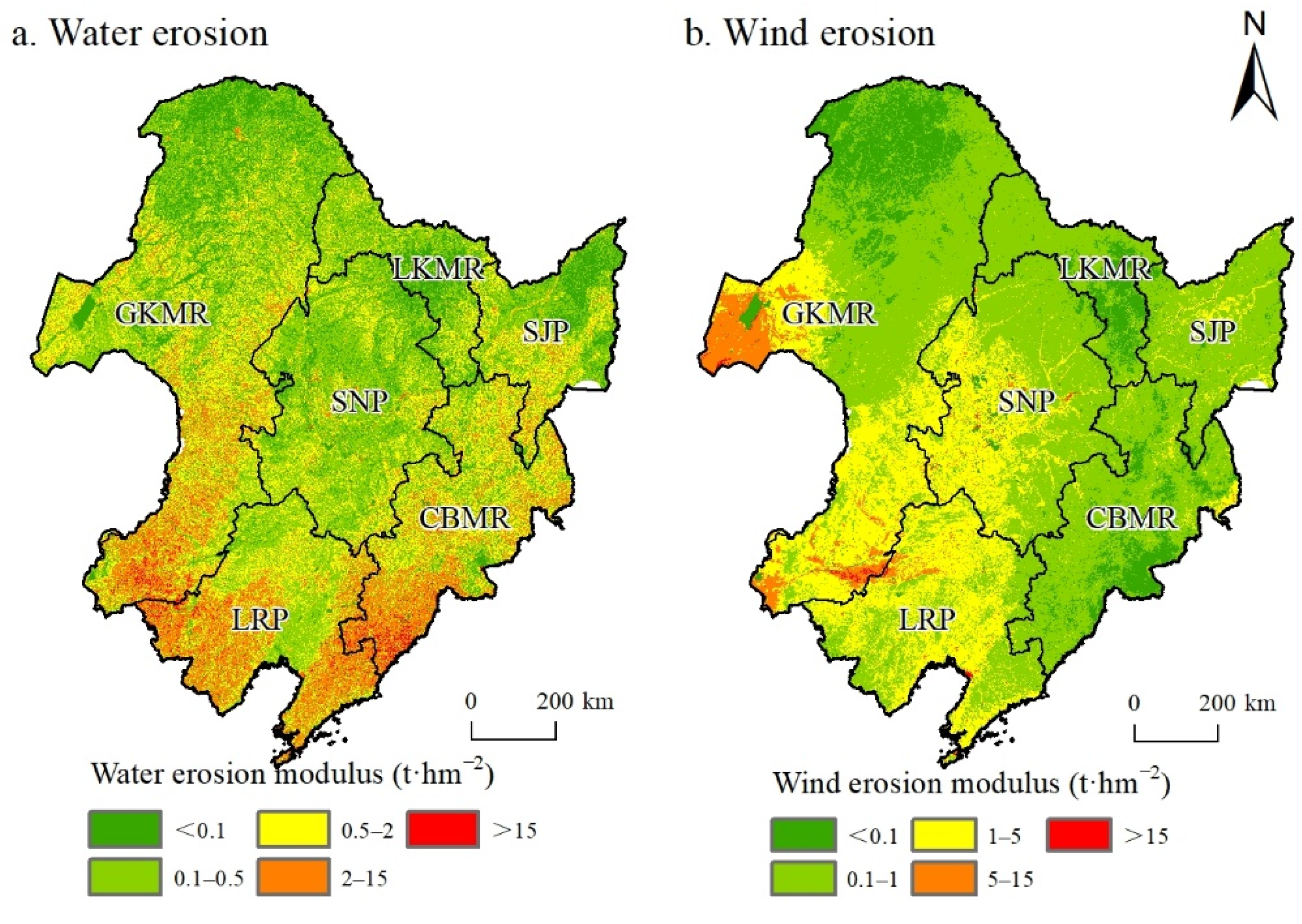
From 2000 to 2020, the multi-year mean water erosion modulus in Northeast China was 1.52 t·hm−2 and the multi-year mean water erosion amount was 1.88 × 10⁸ t (Table 2). The degree of water erosion in Northeast China was mainly slight and its area was about 1,030,166.8 km2, accounting for 83.3% of the total study area. Light erosion was the second most prevalent degree of water erosion, affecting an area of 200,228.4 km2, or about 16.2% of the total area. The moderate and intensive water erosion areas were 4574.8 km2 and 983.2 km2, respectively, accounting for 0.4% and 0.1% (Table 3). Those areas could be found in Chifeng City (IM) and Chaoyang and Huludao in western LN (Figure 2).
The condition of water erosion in each sub-region indicates that the LRP underwent the most severe water erosion, with a multi-year mean erosion modulus of 3.24 t·hm−2, followed by the CBMR and the GKMR, with a water erosion modulus of 2.66 and 1.28 t·hm−2, respectively. Different ecosystems undergo different degrees of water erosion, namely bare land, grassland, forests, and cropland, from the most severe to the least affected (sorted by the water erosion modulus from large to small). The water erosion modulus in cropland was only 1.14 t·hm−2, far lower than that in other ecosystems (Table 2).
Northeast China’s multi-year mean wind erosion modulus was 1.13 t·hm−2 and the wind erosion amount was 1.4 × 10⁸ t (Table 2). The degree of wind erosion in Northeast China was also slight. Its area was about 1,072,463.6 km2, accounting for 86.7% of the total study area. Light erosion was the second most prevalent degree of wind erosion, affecting an area of 163,686.1 km2, or about 13.2% of the total area. The moderate and intensive wind erosion mainly occur in IM, and their total area was 615.6 km2, accounting for about 0.1% (Table 3).
The condition of wind erosion in each sub-region indicates that the LRP and the GKMR underwent the most severe wind erosion, with a multi-year mean modulus of 1.59 and 1.51 t·hm−2, respectively. They were followed by the SNP, with a wind erosion modulus of 1.15 t·hm−2. The wind erosion moduli in the SJP, the LKMR, and the CBMR were small. Regarding the wind erosion condition in different ecosystems, the erosion moduli of bare land and grassland were the largest, which were 3.99 and 2.30 t·hm−2, respectively. The wind erosion moduli of cropland and forests were smaller, at 0.36 and 0.18 t·hm−2, respectively (Table 2).
By comparing the assessment results of water and wind erosion in Northeast China, we could find that in the past two decades, the primary type of erosion in Northeast China was water erosion; the percentage of water erosion at light and higher degrees was 3.4% more than wind erosion and the multi-year mean amount of water erosion was 34.3% more than wind erosion. The results indicate that water erosion was more severe than wind erosion in Northeast China.

3.2. Changes in Soil Erosion

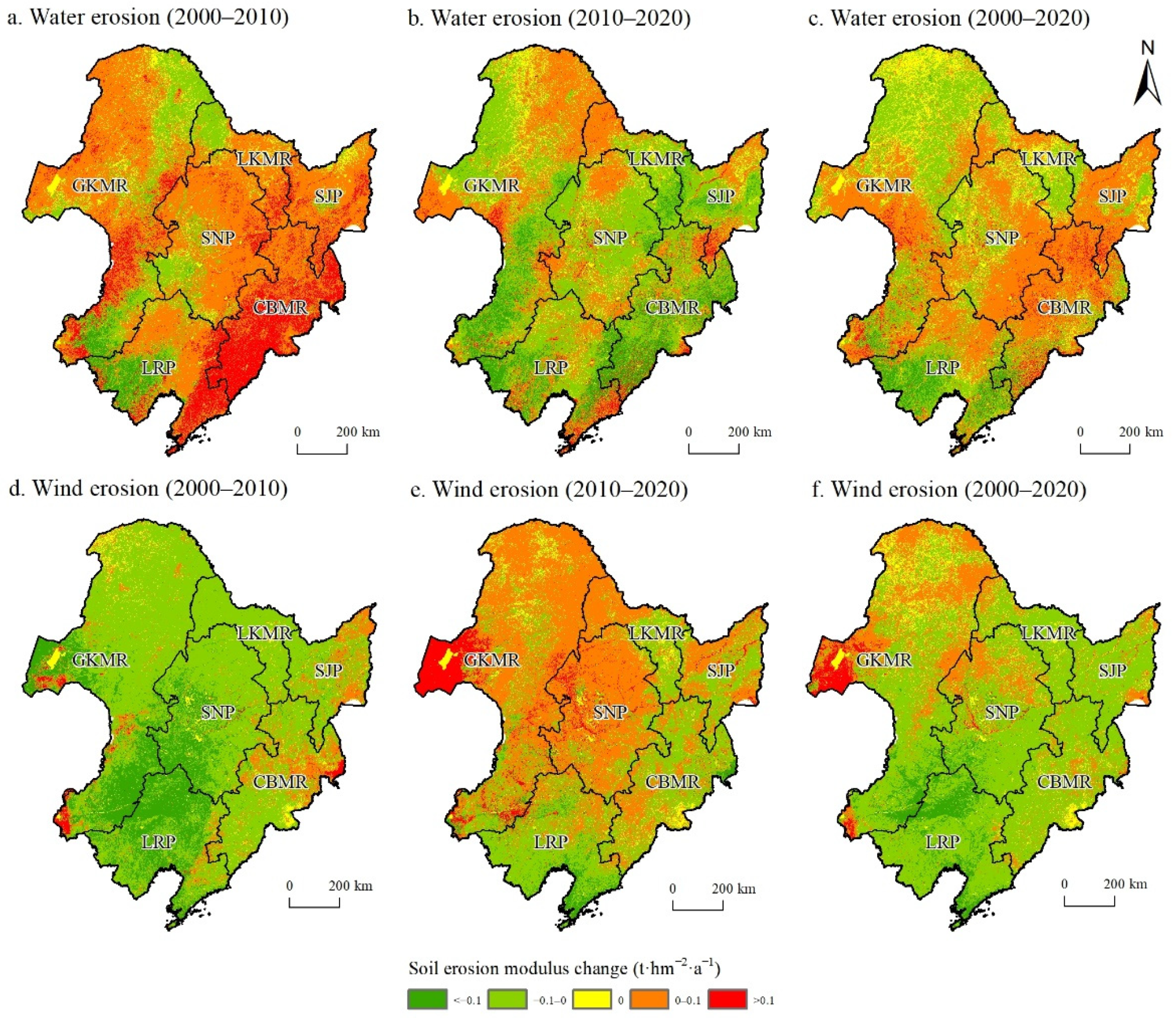
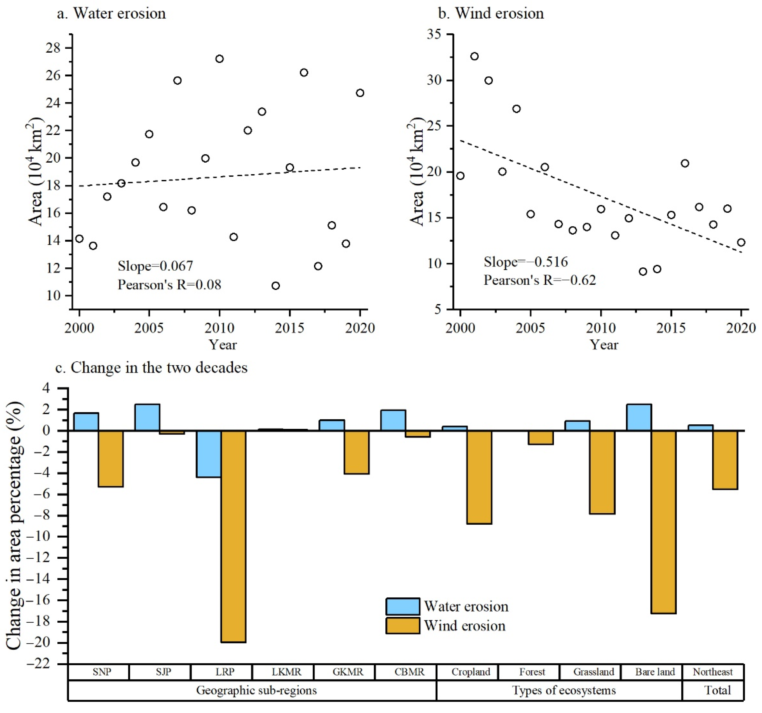
From 2000 to 2020, water erosion in Northeast China had an overall intensifying trend (Figure 3). The area of water erosion at light or higher degrees increased by 672.1 km2 per year on average. Most regions (except LRP) had a greater area of water erosion at light or higher degrees in the latter decade (2010–2020) than in the first decade (2000–2010) (Figure 4). In the past 20 years, the water erosion modulus in Northeast China increased by 0.001 t·hm−2 per year on average. Among the sub-regions, the CBMR, the SJP, and the SNP’s water erosion showed an intensifying trend, increasing by 0.038, 0.017, and 0.012 t·hm−2, respectively. At the same time, the LRP’s water erosion showed a moderating trend and decreased by 0.066 t·hm−2 (Table 2).
Different types of ecosystems showed different change trends of water erosion. The water erosion in bare land and cropland increased significantly, as seen from their interannual variation rates of water erosion modulus at 0.01 and 0.002 t·hm−2·a−1, respectively. On the contrary, grassland and forests’ water erosion showed a decreasing trend at the rates of −0.007 and −0.002 t·hm−2·a−1, respectively (Table 2).
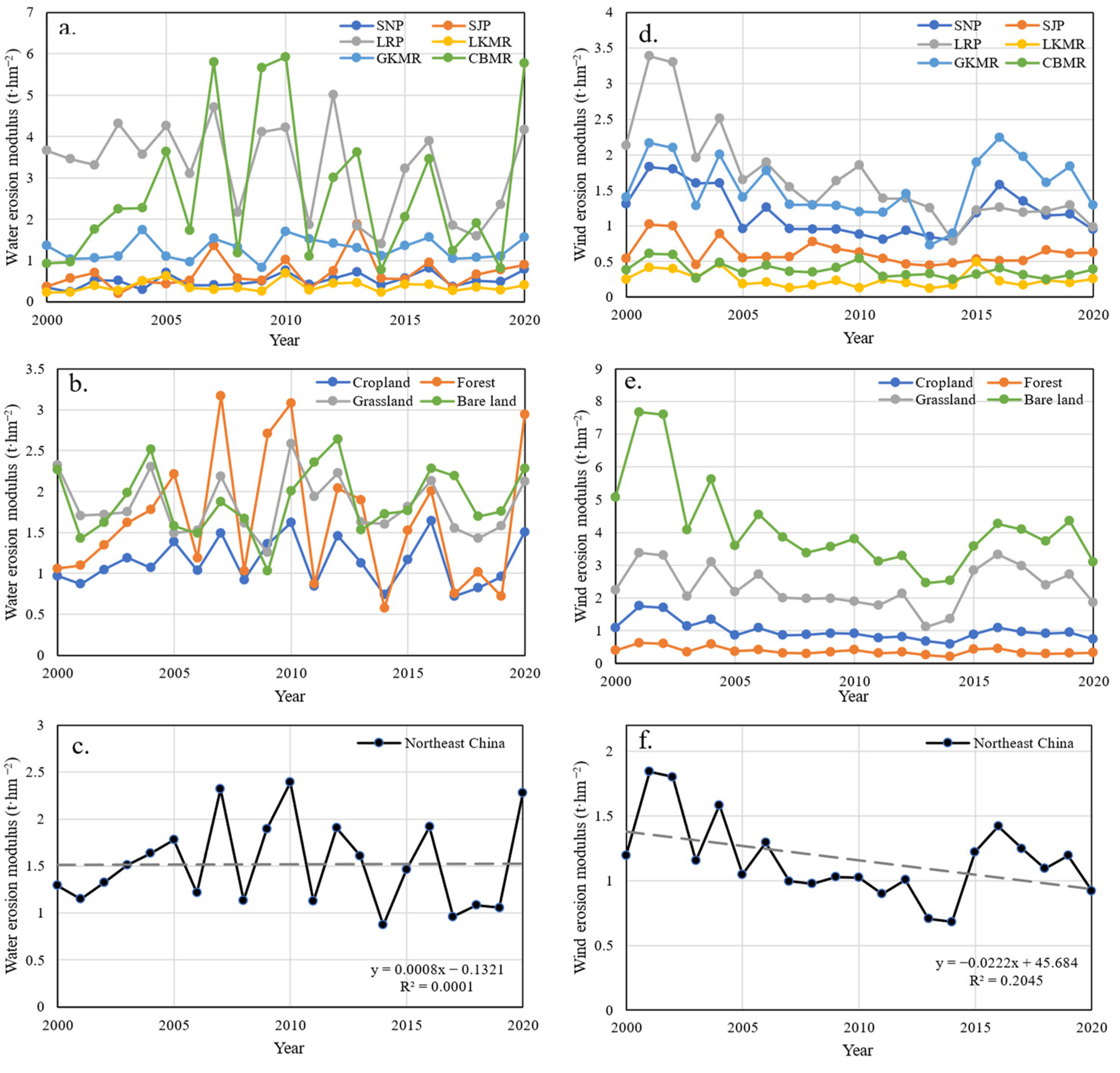
Figure 5 shows the year-by-year changes in soil erosion in Northeast China. From 2000 to 2005, the water erosion modulus in Northeast China increased steadily, but after 2005 the fluctuation of the modulus was significant, mainly due to the dramatic fluctuation of water erosion moduli in sub-regions such as the CBMR and the LRP (LN) (Figure 5a). The changing trend in the water erosion modulus in the two sub-regions was still close to the overall modulus trend in Northeast China. If we compare the water erosion condition of the first and the second decades from 2000 to 2020, we find that, except for the LRP, the other sub-regions have all shown a trend where the area of slight water erosion decreased, and that of light water erosion increased. The trend means the slight water erosion in some areas has intensified into light erosion. The mean water erosion modulus of the first decade in Northeast China was 1.60 t·hm−2 and the water erosion amount was 1.98 × 10⁸ t. In the second decade, the mean water erosion modulus was 1.51 t·hm−2 and the water erosion amount was 1.87 × 10⁸ t. The water erosion amount in the second decade decreased by 5.6%, indicating that the capacity for soil conservation in Northeast China has improved. In the second decade, the water erosion amount in cropland and forests decreased by 2.7% and 14.1%, respectively, while the water erosion for bare land increased by 14.3%. Regarding the interannual variation rate of water erosion, the erosion modulus in Northeast China increased by 0.083 t·hm−2 per year in the first decade and decreased by 0.032 t·hm−2 per year on average in the second decade. The interannual variation rates of the water erosion modulus in the second decade for every type of ecosystem (except for bare land) were all smaller than that in the first decade, which means the water erosion has been alleviated to a certain extent in the second decade (Figure 3 and Table 2).
From 2000 to 2020, wind erosion in Northeast China had an overall moderating trend (Figure 3). The area of slight wind erosion increased by 5161.3 km2 per year on average, and the area of light, moderate, and intensive wind erosion all decreased slightly. The decrease amounts in those degrees were 5143.4 km2, 17.0 km2, and 0.9 km2 per year, respectively (Table 3). The wind erosion modulus decreased by 0.023 t·hm−2 per year on average, and among the sub-regions, the LRP’s wind erosion modulus decreased by 0.089 t·hm−2, which was much higher than others.
Different ecosystems showed different degrees of decreasing trends of wind erosion. The wind erosion in bare land and cropland decreased significantly, as seen from their interannual variation rates of wind erosion modulus at −0.13 and −0.03 t·hm−2·a−1, respectively. Grasslands’ and forests’ wind erosion showed a slightly decreasing trend at the rates of −0.02 and −0.01 t·hm−2·a−1, respectively (Table 2).
Regarding the year-by-year changes in wind erosion modulus in Northeast China (Figure 5), there was a gradually decreasing trend in fluctuations from 2000 to 2014. After 2014, the wind erosion modulus rebounded, mainly because the soil erosion amount in the GKMR (primarily in IM) increased significantly during this period. In terms of ecosystem types, the year-by-year changes in wind erosion in bare land had pronounced fluctuation, followed by grasslands. Wind erosion in forests was relatively stable. If we compare the condition of the first and the second decades from 2000 to 2020, we find that all sub-regions have shown a trend where the area of slight wind erosion increased, and that of light wind erosion decreased. The trend means the light degree of wind erosion has alleviated to a slight one. The mean wind erosion modulus of the first decade in Northeast China was 1.27 t·hm−2 and the wind erosion amount was 1.57 × 10⁸ t. In the second decade, the mean wind erosion modulus was 1.04 t·hm−2 and the wind erosion amount was 1.29 × 10⁸ t. The wind erosion amount in the second decade decreased by 18.2%, indicating that the wind erosion in Northeast China has alleviated significantly. In the second decade, the wind erosion amount in bare land, cropland, grassland, and forests decreased by 28.3%, 26.4%, 24.6%, and 8.0%, respectively. Regarding the interannual variation rate of wind erosion, the process in Northeast China showed a trend of decreasing before increasing, but it was overall decreasing. The wind erosion modulus in Northeast China decreased by 0.067 t·hm−2 per year on average in the first decade and increased by 0.025 t·hm−2 per year in the second decade. Among the different types of ecosystems, the forests’ wind erosion modulus showed a decreasing trend in the first and second decades. This fact indicates that although the wind erosion modulus of the forests in Northeast China did not decrease significantly, the forests can still perform long-term windbreak and sand fixation. Regarding the difference among the geographical sub-regions, the wind erosion moduli in the LRP and the CBMR showed a decreasing trend in both decades, while other sub-regions decreased before increasing during the decades. In general, wind erosion in Northeast China showed a decreasing trend from 2000 to 2020. The wind erosion rate decreased rapidly in the first decade and then decreased slowly or even increased in the second decade (Figure 3 and Table 2).

4. Discussion

4.1. Assessment Results of Soil Erosion

In this paper, we conducted an in-depth analysis of the spatial and temporal evolution of water and wind erosion in Northeast China from 2000 to 2020. The results indicate that the erosion degree in Northeast China was mainly slight, followed by light erosion. The moderate and intensive erosion areas were few. This result was consistent with that of Wang et al. [48]. In addition, Wang et al. [48] suggested that the proportion of erosion areas with light and higher degrees was slightly higher than that in this paper, which may be due to differences in assessment methods. In this study, we adopted the RUSLE and RWEQ models to evaluate the amount of water and wind erosion quantitatively. Meanwhile, the soil erosion results from [48] come through the interpretation of remote sensing images, comprehensively considering reference indicators, such as land cover type, gully density, vegetation structure and coverage, slope, elevation, soil type, and others, which belong to qualitative analyses. In other existing studies, Wang et al. [83] used the RUSLE model to estimate water erosion in Northeast China from 2000 to 2018 and the results suggested that the CBMR and the LRP underwent severer water erosion, which was consistent with the results here. In addition, the results of this paper show that although water erosion has increased overall in the last 20 years, the degree of water erosion has decreased in the second decade compared with the first decade, which means that the sharp increase in water erosion mainly occurred in the first decade. The research results of Jiang et al. [84] showed that water erosion in HLJ showed an increasing trend before 2005 and a weakening trend after 2005, which is basically consistent with the results of this paper, mainly due to the government’s emphasis on soil erosion control. In 2008, policy makers carried out some projects, such as the key erosion control project and the integrated prevention and control pilot project in the black soil region of Northeast China, and the development and implementation of these policies effectively mitigated soil erosion in the second decade in Northeast China. The research results of Li et al. [85] on the changes in wind erosion in IM suggested that wind erosion has a significant decreasing trend among fluctuations, which was also basically consistent with our results. In addition, a study from Yang et al. [86] on the number of days under wind erosion in the three northeastern provinces (HLJ, JL, and LN) suggested that the LRP, the SJP, and the SNP had more days of wind erosion, which was largely consistent with our results as well.

4.2. Influencing Factors of Soil Erosion

Soil erosion in Northeast China develops under various types of complex processes. Its prominent features include multi-force coupling, multi-process overlapping, and significant influences from freezing and thawing [71,87]. The influencing factors of water erosion include rainfall, rainfall intensity, duration [88], and other relevant factors such as vegetation, soil, and terrain. However, these factors may be susceptible to the influence of human activities. For example, land use types, cultivation methods, and crop management may affect vegetation cover, land morphology, and the soil’s physical and chemical properties [89]. In addition, the soil in Northeast China has poor erosion resistance and is prone to being affected by freezing and thawing. Meanwhile, over-reclamation, single land use structures, and exploiting management have aggravated soil erosion there [71].
The results of this study revealed that the sub-regions with the most severe water erosion in Northeast China were the CBMR and the LRP, where the terrain is steep and the LS value is high. In addition, the CBMR is close to the Bohai Sea and has abundant rainfall and the highest R value, and its erosion modulus was larger than most of the sub-regions there. The LRP has the highest K and p values and was the main affected area of erosion at intensive or higher degrees. If values of other factors remain high, a slight alternation in the C factor will inevitably result in a significant change in the erosion modulus. The GKMR includes the Greater Kinggan Mountains and the Inner Mongolia Plateau. This sub-region has steep terrain and covers many areas with high K, LS, C, and p values [83].
Due to the limitations of observation and research methods, wind erosion studies in Northeast China were scarcer than water erosion studies. Multiple factors can cause wind erosion, including wind speed, precipitation, soil water content, soil texture (such as soil structure, particle composition, and others), vegetation cover, and cultivation methods [86,90]. Our results revealed that the wind erosion in the GKMR was more severe than in other sub-regions. The sub-region covers a part of the Inner Mongolia Plateau, which is an arid and semi-arid area and a hot spot for wind erosion studies.
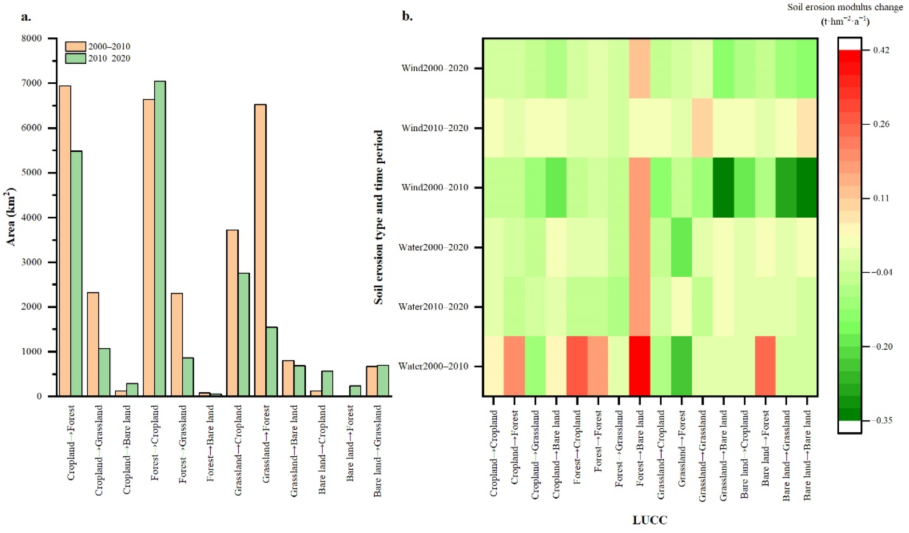
Under the influence of human activities, land use types in Northeast China have changed significantly. Over-reclamation, over-harvesting, and over-grazing have reduced vegetation coverage, and cropland, forests, and grassland have become the primary land use types affected by soil erosion [48]. From 2000 to 2020, the land use type conversion in Northeast China was mainly the conversion between cropland and forest and between cropland and grassland (Figure 6a). From 2000 to 2010, a large area of grassland was converted to cropland and bare land, and there were also forests converted to grassland. The surface vegetation there was destroyed due to over-exploitation and grassland’s reclamation into cropland, and degradation into sandy and saline–alkali land. The vegetation’s destruction loosened the soil, thus aggravating the water and soil losses. Later, under conservation tillage methods such as the conversion of cropland to forests and natural forest protection projects, the area of forest to grassland, grassland to cropland, and grassland to bare land in the second decade reduced remarkably. More bare land has been converted into forests and grasslands, alleviating water and soil losses. However, we found that forests in some areas were also reclaimed as cropland (from the increase in the reclaimed area in the second decade), which aggravated the water and soil losses.
Figure 6b shows the differences between LUCC and soil erosion changes in Northeast China during specific periods. For the areas where the land converted from forest to bare land, their water and wind erosion moduli showed an increasing trend in each period, which means the soil erosion in these areas was aggravated. From 2000 to 2010, the wind erosion modulus decreased significantly in areas where the land was converted from bare land to cropland, to forests, and to grassland. In addition, almost all the water and wind erosion moduli showed a decreasing trend in the areas where the land was converted to forests and grassland. This fact suggests that forests and grassland can assist soil conservation and sand fixation in Northeast China. However, the responses of water erosion to land use changes from 2000 to 2010 also reveal that the areas converted into forests underwent increased water erosion, which was quite different from the above results. This extraordinary result may be related to the rainfall factor during this period.

4.3. Methods to Moderate Soil Erosion

Soil erosion control and the protection of black soil in Northeast China is urgent and this has become a consensus among people. Based on the above-mentioned factors influencing soil erosion, we can find some methods to moderate soil erosion. For example, we should prioritize improving vegetation coverage in LRP since it is a prominent factor in countering soil erosion. In addition, to address erosion in GKMR, we should first reduce the impact of rainfall on erosion by reducing slope cropland and implementing conservation tillage methods such as zero tillage. In terms of LUCC, changes in cropland and bare land (i.e., cultivation reversion and wasteland elimination) can help reduce soil erosion. Conversely, the loss of forests and grasslands aggravates soil erosion. In recent years, policymakers have attached great importance to cropland protection in Northeast China. In 2021, the government issued a document stating, “we will implement the national black soil protection project and promote conservation tillage methods”, which upgraded the protection of black soil in Northeast China into a national strategy. The Ministry of Water Resources has compiled the Outline of the Black Soil Protection Plan in Northeast China (2017–2030), and the region has gradually applied conservation tillage methods such as zero tillage, less tillage, cross ridge tillage, and straw mulching to address soil erosion and water and soil losses there. Previous studies have suggested that zero tillage with straw mulching has multiple advantages. For example, it can improve soil structure and structural stability and increase water conservation capacity and overall soil quality to reduce water erosion [91]. In addition, compared to longitudinal ridge tillage, cross ridge tillage can better retain water and soil, thus reducing organic carbon loss and increasing crop yield [92,93]. For wind erosion, conservation tillage methods, such as zero tillage, subsoiling, ridge cultivation, and straw mulching, are available. They act to alleviate wind erosion by reducing soil disturbance and increasing stubble-mulching on the soil surface. Furthermore, these prevention and control measures for soil erosion (strip cropping, contour farming, contour bunds, and terracing) are evidenced in the Ukrainian plain [94], which is also one of the four major black soil regions in the world and very similar to Northeast China.

4.4. Limitations and Future Research

Our study still has some uncertainties and pending questions: (1) Soil erosion was caused by multiple factors such as climate, topography, soil, vegetation, and human activities. Factors such as climate change and cultivation methods may also impact changes in soil erosion. Our study only discussed the temporal and spatial evolution of soil erosion in Northeast China over the past two decades and the reasons behind the changes. The quantitative analysis of the driving factors of those changes in Northeast China requires systematic and in-depth research. (2) Our study only considered water and wind erosion, and the freeze–thaw cycle was not included. As a prominent process of soil erosion in Northeast China, the freeze–thaw cycle can aggravate water erosion by affecting soil hydrological properties and reducing erosion resistance. (3) Soil erosion may be affected by temporal alternation or synchronization and spatial intersection or overlapping. Thus, various erosion types such as water and wind erosion in Northeast China coexist and interact with each other. Herein, we discussed water and wind erosion in Northeast China separately, but our study did not include the interaction between them. (4) Although this study reveals the changes of soil erosion in Northeast China to some extent, experimental data are lacking to verify the accuracy. To improve the estimation accuracy of the amount of soil erosion, researchers should further localize the parameters of the management factors in the erosion equation in combination with field investigation. (5) Vegetation and crop growth are also affected by the seasonal distribution of temperature and precipitation. Thus, there are significant seasonal changes in erosion intensity in Northeast China. This feature also deserves further study [71]. (6) There are differences in soil status, erosion characteristics, and planting patterns in different climatic sub-regions, which lead to differences in the applicability of conservation tillage methods in different areas in Northeast China. Future studies may need to include the climates and their changes and soil and agricultural production status of each sub-region in Northeast China to screen and propose conservation tillage methods suitable for specific regions.

5. Conclusions

Based on the RUSLE and the RWEQ models, this paper assessed the water and wind erosion on the soil in Northeast China from 2000 to 2020 and analyzed the current situation, as well as the spatial and temporal evolution of soil erosion. The results suggest that:
(1) Northeast China’s multi-year mean water and wind erosion moduli were 1.52 t·hm−2 and 1.13 t·hm−2, respectively, and the water and wind erosion amounts were 1.88 × 10⁸ t and 1.4 × 10⁸ t, respectively. The degree of soil erosion in Northeast China was mainly slight, and water erosion was more severe than wind erosion. Water and wind erosion in bare land and grassland were more intensive than in cropland and forests. The LRP has undergone relatively intensive water erosion, while the wind erosion in the GKMR was more intensive than in other sub-regions.
(2) There was a slight intensifying trend in water erosion in Northeast China from 2000 to 2020, which can be found in its increased water erosion modulus at 0.001 t·hm−2 per year on average. From a spatial view, the area of slight water erosion decreased, and that of light and intensive water erosion increased. The water erosion in the CBMR, the SJP, and the SNP intensified, while the LRP underwent water erosion slower than before. The water erosion in bare land and cropland intensified, while the water erosion in grassland and forests slowed down. On a temporal scale, the results reveal that compared to the first decade, the second decade in the timespan of the study had a reversed change trend of water erosion from intensifying to moderating, which means the soil retention capacity in Northeast China has improved, and water erosion of the soil there has been alleviated to some degree.
(3) There was a moderating trend in wind erosion in Northeast China from 2000 to 2020, which can be found in its decreased wind erosion modulus at 0.023 t·hm−2 per year on average. The area of slight wind erosion increased, and that of light, moderate, and intensive wind erosion decreased. The wind erosion in the LRP had a pronounced decrease and the wind erosion in bare land and cropland also decreased considerably. The decrease in wind erosion in grassland and forest was relatively slight. The amount of wind erosion in the second decade decreased by 18.2% compared to the first decade. The rate of wind erosion decreased faster in the first decade, but in the second decade, it decreased slowly or even increased. The two facts indicate that wind erosion in Northeast China has alleviated, but this trend is gradually slowing down.
Soil erosion is caused by multiple factors, such as climate, topography, soil, and human activities. This study has important implications for our understanding of soil erosion control and management in Northeast China. For example, in sub-regions with severe erosion, such as the LRP and the GKMR, we can adopt methods such as zero tillage, cross ridge tillage, and straw mulching according to the local characteristics of soil erosion to slow down the process.

Author Contributions

Conceptualization, S.W. and X.X.; methodology, S.W.; validation, S.W.; formal analysis, S.W.; resources, X.X. and L.H.; data curation, X.X.; writing—original draft preparation, S.W.; writing—review and editing, X.X. and L.H. All authors have read and agreed to the published version of the manuscript.

Funding

This research was funded by National Key R&D Program of China (Grant number 2021YFD1500101) and the Special Funds for Creative Research (Grant number 2022C61540).

Institutional Review Board Statement

Not applicable.

Informed Consent Statement

Not applicable.

Data Availability Statement

Not applicable.

Acknowledgments

The authors greatly appreciate the reviewers and the editors for their valuable and constructive comments and suggestions that improved the manuscript.

Conflicts of Interest

The authors declare no conflict of interest.

Abbreviations

RUSLEthe Revised Universal Soil Loss Equation
RWEQthe Revised Wind Erosion Equation
SNPthe Songnen Plain
SJPthe Sanjiang Plain
LRPthe Liao River Plain
LKMRthe Lesser Kinggan Mountains Region
GKMRthe Greater Kinggan Mountains Region
CBMRthe Changbai Mountain Region
HLJHeilongjiang
JLJilin
LNLiaoning
IMInner Mongolia
LUCCland use/cover change
NDVInormalized difference vegetation index
DEMdigital elevation model

References

  1. Cui, L.; Shen, Z.; Liu, Y.; Yu, C.; Lu, Q.; Zhang, Z.; Gao, Y.; Nie, T. Identification of driving forces for windbreak and sand fixation services in semiarid and arid areas: A case of Inner Mongolia, China. Prog. Phys. Geogr.-Earth Environ. 2022. [Google Scholar] [CrossRef]
  2. Peng, J.; Hu, Y.n.; Dong, J.; Mao, Q.; Liu, Y.; Du, Y.; Wu, J.; Wang, Y. Linking spatial differentiation with sustainability management: Academic contributions and research directions of physical geography in China. Prog. Phys. Geogr.-Earth Environ. 2020, 44, 14–30. [Google Scholar] [CrossRef]
  3. Du, H.; Dou, S.; Deng, X.; Xue, X.; Wang, T. Assessment of wind and water erosion risk in the watershed of the Ningxia-Inner Mongolia Reach of the Yellow River, China. Ecol. Indic. 2016, 67, 117–131. [Google Scholar] [CrossRef]
  4. Wan, W.; Liu, Z.; Li, B.; Fang, H.; Wu, H.; Yang, H. Evaluating soil erosion by introducing crop residue cover and anthropogenic disturbance intensity into cropland C-factor calculation: Novel estimations from a cropland-dominant region of Northeast China. Soil Tillage Res. 2022, 219, 105343. [Google Scholar] [CrossRef]
  5. Li, Z.; Fang, H. Impacts of climate change on water erosion: A review. Earth-Sci. Rev. 2016, 163, 94–117. [Google Scholar] [CrossRef]
  6. Wang, X.; Zhao, X.; Zhang, Z.; Yi, L.; Zuo, L.; Wen, Q.; Liu, F.; Xu, J.; Hu, S.; Liu, B. Assessment of soil erosion change and its relationships with land use/cover change in China from the end of the 1980s to 2010. Catena 2016, 137, 256–268. [Google Scholar] [CrossRef]
  7. Sartori, M.; Philippidis, G.; Ferrari, E.; Borrelli, P.; Lugato, E.; Montanarella, L.; Panagos, P. A linkage between the biophysical and the economic: Assessing the global market impacts of soil erosion. Land Use Policy 2019, 86, 299–312. [Google Scholar] [CrossRef]
  8. Wan, W.; Han, Y.; Wu, H.; Liu, F.; Liu, Z. Application of the source-sink landscape method in the evaluation of agricultural non-point source pollution: First estimation of an orchard-dominated area in China. Agric. Water Manag. 2021, 252, 106910. [Google Scholar] [CrossRef]
  9. Huang, D.; Pei, M.; Zhou, L.; Fan, H.; Jia, Y. Identification of sediment sources and exploration of scale effects in the black soil region of Northeast China. Catena 2020, 195, 104848. [Google Scholar] [CrossRef]
  10. Poesen, J. Soil erosion in the Anthropocene: Research needs. Earth Surf. Process. Landf. 2018, 43, 64–84. [Google Scholar] [CrossRef]
  11. Gu, Z.; Xie, Y.; Gao, Y.; Ren, X.; Cheng, C.; Wang, S. Quantitative assessment of soil productivity and predicted impacts of water erosion in the black soil region of northeastern China. Sci. Total Environ. 2018, 637, 706–716. [Google Scholar] [CrossRef] [PubMed]
  12. Wen, Y.; Kasielke, T.; Li, H.; Zepp, H.; Zhang, B. A case-study on history and rates of gully erosion in Northeast China. Land Degrad. Dev. 2021, 32, 4254–4266. [Google Scholar] [CrossRef]
  13. Liu, X.; Zhang, S.; Zhang, X.; Ding, G.; Cruse, R.M. Soil erosion control practices in Northeast China: A mini-review. Soil Tillage Res. 2011, 117, 44–48. [Google Scholar] [CrossRef]
  14. Chen, H.; Liu, G.; Zhang, X.; Shi, H.; Li, H. Quantifying sediment source contributions in an agricultural catchment with ephemeral and classic gullies using Cs-137 technique. Geoderma 2021, 398, 115112. [Google Scholar] [CrossRef]
  15. Dong, Y.; Wu, Y.; Qin, W.; Guo, Q.; Yin, Z.; Duan, X. The gully erosion rates in the black soil region of northeastern China: Induced by different processes and indicated by different indexes. Catena 2019, 182, 104146. [Google Scholar] [CrossRef]
  16. Yan, Y.; Zhang, S.; Li, X.; Yue, S. Temporal and Spatial Variation of Erosion Gullies in Kebai Black Soil Region of Heilongjiang during the Past 50 Years. Acta Geogr. Sin. 2005, 60, 1015–1020. [Google Scholar]
  17. Wang, B.; Zhang, Z.; Wang, X.; Zhao, X.; Yi, L.; Hu, S. Object-Based Mapping of Gullies Using Optical Images: A Case Study in the Black Soil Region, Northeast of China. Remote Sens. 2020, 12, 487. [Google Scholar] [CrossRef] [Green Version]
  18. Huang, D.; Du, P.; Wang, J.; Wei, X.; Liu, B.; Xu, J. Using reservoir deposits to quantify the source contributions to the sediment yield in the Black Soil Region, Northeast China, based on the fingerprinting technique. Geomorphology 2019, 339, 1–18. [Google Scholar] [CrossRef]
  19. Zhang, Y.; Wu, Y.; Lin, B.; Zheng, Q.; Yin, J. Characteristics and factors controlling the development of ephemeral gullies in cultivated catchments of black soil region, Northeast China. Soil Tillage Res. 2007, 96, 28–41. [Google Scholar] [CrossRef]
  20. Lu, J.; Zheng, F.; Li, G.; Bian, F.; An, J. The effects of raindrop impact and runoff detachment on hillslope soil erosion and soil aggregate loss in the Mollisol region of Northeast China. Soil Tillage Res. 2016, 161, 79–85. [Google Scholar] [CrossRef]
  21. Shen, C.; Wang, Y.; Zhao, A.; Xu, X.; Yang, X.; Liu, X. Characteristics of material migration during soil erosion in sloped farmland in the black soil region of Northeast China. Trop. Conserv. Sci. 2019, 12, 1940082919856835. [Google Scholar] [CrossRef]
  22. Huang, D.; Su, L.; Zhou, L.; Fan, H. Gully is the dominant sediment source of snowmelt erosion in the black soil region-A case study. Soil Tillage Res. 2022, 215, 105232. [Google Scholar] [CrossRef]
  23. Nearing, M.A.; Xie, Y.; Liu, B.; Ye, Y. Natural and anthropogenic rates of soil erosion. Int. Soil Water Conserv. Res. 2017, 5, 77–84. [Google Scholar] [CrossRef]
  24. Wang, H.; Yang, S.; Wang, Y.; Gu, Z.; Xiong, S.; Huang, X.; Sun, M.; Zhang, S.; Guo, L.; Cui, J.; et al. Rates and causes of black soil erosion in Northeast China. Catena 2022, 214, 106250. [Google Scholar] [CrossRef]
  25. Shen, H.O.; Wang, D.L.; Wen, L.L.; Zhao, W.T.; Zhang, Y. Soil Erosion and Typical Soil and Water Conservation Measures on Hillslopes in the Chinese Mollisol Region. Eurasian Soil Sci. 2020, 53, 1509–1519. [Google Scholar] [CrossRef]
  26. Wen, L.; Zheng, F.; Shen, H.; Bian, F.; Jiang, Y. Rainfall intensity and inflow rate effects on hillslope soil erosion in the Mollisol region of Northeast China. Nat. Hazards 2015, 79, 381–395. [Google Scholar] [CrossRef]
  27. Fan, X.; Fan, H.; Dong, S. The coupling of hillslope- and gully-erosion increases their controlling efforts: A case study in Liaoning Province, China. Soil Water Res. 2022, 17, 123–137. [Google Scholar] [CrossRef]
  28. Hu, G.; Wu, Y.; Liu, B.; Yu, Z.; You, Z.; Zhang, Y. Short-term gully retreat rates over rolling hill areas in black soil of Northeast China. Catena 2007, 71, 321–329. [Google Scholar] [CrossRef]
  29. Wang, R.; Sun, H.; Yang, J.; Zhang, S.; Fu, H.; Wang, N.; Liu, Q. Quantitative Evaluation of Gully Erosion Using Multitemporal UAV Data in the Southern Black Soil Region of Northeast China: A Case Study. Remote Sens. 2022, 14, 1479. [Google Scholar] [CrossRef]
  30. Tang, J.; Liu, G.; Xie, Y.; Dun, X.; Wang, D.; Zhang, S. Annual variation of ephemeral gully erosion in a cultivated catchment. Geoderma 2021, 401, 115166. [Google Scholar] [CrossRef]
  31. Du, Z.; Gao, B.; Ou, C.; Du, Z.; Yang, J.; Batsaikhan, B.; Dorjgotov, B.; Yun, W.; Zhu, D. A Quantitative Analysis of Factors Influencing Organic Matter Concentration in the Topsoil of Black Soil in Northeast China Based on Spatial Heterogeneous Patterns. Isprs Int. J. Geo-Inf. 2021, 10, 348. [Google Scholar] [CrossRef]
  32. Li, H.; Zhu, H.; Liang, C.; Wei, X.; Yao, Y. Soil erosion significantly decreases aggregate-associated OC and N in agricultural soils of Northeast China. Agric. Ecosyst. Environ. 2022, 323, 107677. [Google Scholar] [CrossRef]
  33. Li, H.; Zhu, H.; Qiu, L.; Wei, X.; Liu, B.; Shao, M. Response of soil OC, N and P to land-use change and erosion in the black soil region of the Northeast China. Agric. Ecosyst. Environ. 2020, 302, 107081. [Google Scholar] [CrossRef]
  34. Li, T.; Zhang, H.; Wang, X.; Cheng, S.; Fang, H.; Liu, G.; Yuan, W. Soil erosion affects variations of soil organic carbon and soil respiration along a slope in Northeast China. Ecol. Process. 2019, 8, 28. [Google Scholar] [CrossRef] [Green Version]
  35. Liu, H.; Zhang, T.; Liu, B.; Liu, G.; Wilson, G.V. Effects of gully erosion and gully filling on soil depth and crop production in the black soil region, northeast China. Environ. Earth Sci. 2013, 68, 1723–1732. [Google Scholar] [CrossRef]
  36. Zhao, P.; Li, S.; Wang, E.; Chen, X.; Deng, J.; Zhao, Y. Tillage erosion and its effect on spatial variations of soil organic carbon in the black soil region of China. Soil Tillage Res. 2018, 178, 72–81. [Google Scholar] [CrossRef]
  37. Fang, H.; Sun, L.; Qi, D.; Cai, Q. Using Cs-137 technique to quantify soil erosion and deposition rates in an agricultural catchment in the black soil region, Northeast China. Geomorphology 2012, 169, 142–150. [Google Scholar] [CrossRef]
  38. Yu, Y.; Zhang, K.; Liu, L.; Ma, Q.; Luo, J. Estimating long-term erosion and sedimentation rate on farmland using magnetic susceptibility in northeast China. Soil Tillage Res. 2019, 187, 41–49. [Google Scholar] [CrossRef]
  39. Li, M.; Li, T.; Zhu, L.; Meadows, M.E.; Zhu, W.; Zhang, S. Effect of Land Use Change on Gully Erosion Density in the Black Soil Region of Northeast China from 1965 to 2015: A Case Study of the Kedong County. Front. Environ. Sci. 2021, 9, 652933. [Google Scholar] [CrossRef]
  40. Wang, B.; Zhang, Z.; Wang, X.; Zhao, X.; Yi, L.; Hu, S. The Suitability of Remote Sensing Images at Different Resolutions for Mapping of Gullies in the Black Soil Region, Northeast China. Remote Sens. 2021, 13, 2367. [Google Scholar] [CrossRef]
  41. Wang, R.; Zhang, S.; Pu, L.; Yang, J.; Yang, C.; Chen, J.; Guan, C.; Wang, Q.; Chen, D.; Fu, B.; et al. Gully Erosion Mapping and Monitoring at Multiple Scales Based on Multi-Source Remote Sensing Data of the Sancha River Catchment, Northeast China. Isprs Int. J. Geo-Inf. 2016, 5, 200. [Google Scholar] [CrossRef]
  42. Wang, J.; Shi, X.; Li, Z.; Zhang, Y.; Liu, Y.; Peng, Y. Responses of runoff and soil erosion to planting pattern, row direction, and straw mulching on sloped farmland in the corn belt of northeast China. Agric. Water Manag. 2021, 253, 106935. [Google Scholar] [CrossRef]
  43. Wen, Y.; Kasielke, T.; Li, H.; Zhang, B.; Zepp, H. May agricultural terraces induce gully erosion? A case study from the Black Soil Region of Northeast China. Sci. Total Environ. 2021, 750, 141715. [Google Scholar] [CrossRef] [PubMed]
  44. Xu, X.; Zheng, F.; Wilson, G.V.; He, C.; Lu, J.; Bian, F. Comparison of runoff and soil loss in different tillage systems in the Mollisol region of Northeast China. Soil Tillage Res. 2018, 177, 1–11. [Google Scholar] [CrossRef]
  45. Yan, Y.; Zhang, X.; Liu, J.; Li, J.; Ding, C.; Qi, Z.; Shen, Q.; Guo, M. The effectiveness of selected vegetation communities in regulating runoff and soil loss from regraded gully banks in the Mollisol region of Northeast China. Land Degrad. Dev. 2021, 32, 2116–2129. [Google Scholar] [CrossRef]
  46. Ma, X.; Zhao, C.; Zhu, J. Aggravated risk of soil erosion with global warming—A global meta-analysis. Catena 2021, 200, 105129. [Google Scholar] [CrossRef]
  47. Xu, X.Z.; Xu, Y.; Chen, S.C.; Xu, S.G.; Zhang, H.W. Soil loss and conservation in the black soil region of Northeast China: A retrospective study. Environ. Sci Policy 2010, 13, 793–800. [Google Scholar] [CrossRef]
  48. Wang, B.; Zhao, X.; Wang, X.; Zhang, Z.; Yi, L.; Hu, S. Spatial and temporal variability of soil erosion in the black soil region of Northeast China from 2000 to 2015. Environ. Monit Assess 2020, 192, 370. [Google Scholar] [CrossRef]
  49. Lin, Y.; Li, H.; Xiao, B. Influencing Factors of Wind Erosion and Their Quantitative Relationships with Erosion Rate in Black Soil Area of Northeast China. J. Soil Water Conserv. 2017, 31, 44–50. [Google Scholar]
  50. Li, H.; Shen, H.; Wang, Y.; Wang, Y.; Gao, Q. Effects of ridge tillage and straw returning on runoff and soil loss under simulated rainfall in the mollisol region of Northeast China. Sustainability 2021, 13, 10614. [Google Scholar] [CrossRef]
  51. Liu, T.; Xu, X.; Yang, J. Experimental study on the effect of freezing-thawing cycles on wind erosion of black soil in Northeast China. Cold Reg. Sci. Technol. 2017, 136, 1–8. [Google Scholar] [CrossRef]
  52. Yan, Y.; Zhen, H.; Zhai, X.; Li, J.; Hu, W.; Ding, C.; Qi, Z.; Qiao, B.; Li, H.; Liu, X.; et al. The role of vegetation on earth bunds in mitigating soil erosion in Mollisols region of Northeast China. Catena 2021, 196, 104927. [Google Scholar] [CrossRef]
  53. Fang, H.J.; Yang, X.M.; Zhang, X.P.; Liang, A.Z. Using Cs-137 tracer technique to evaluate erosion and deposition of black soil in Northeast China. Pedosphere 2006, 16, 201–209. [Google Scholar] [CrossRef]
  54. Wang, Z.; Zeng, Y.; Li, C.; Yan, H.; Yu, S.; Wang, L.; Shi, Z. Telecoupling cropland soil erosion with distant drivers within China. J. Environ. Manag. 2021, 288, 112395. [Google Scholar] [CrossRef] [PubMed]
  55. Yang, X.M.; Zhang, X.P.; Deng, W.; Fang, H.J. Black soil degradation by rainfall erosion in Jilin, China. Land Degrad. Dev. 2003, 14, 409–420. [Google Scholar] [CrossRef]
  56. Evrard, O.; Chaboche, P.A.; Ramon, R.; Foucher, A.; Laceby, J.P. A global review of sediment source fingerprinting research incorporating fallout radiocesium (Cs-137). Geomorphology 2020, 362, 107103. [Google Scholar] [CrossRef]
  57. Phinzi, K.; Ngetar, N.S. The assessment of water-borne erosion at catchment level using GIS-based RUSLE and remote sensing: A review. Int. Soil Water Conserv. Res. 2019, 7, 27–46. [Google Scholar] [CrossRef]
  58. Chi, W.F.; Zhao, Y.Y.; Kuang, W.H.; He, H.L. Impacts of anthropogenic land use/cover changes on soil wind erosion in China. Sci. Total Environ. 2019, 668, 204–215. [Google Scholar] [CrossRef]
  59. Li, J.Y.; Ma, X.F.; Zhang, C. Predicting the spatiotemporal variation in soil wind erosion across Central Asia in response to climate change in the 21st century. Sci. Total Environ. 2020, 709, 136060. [Google Scholar] [CrossRef]
  60. Fu, Q.; Li, B.; Hou, Y.; Bi, X.; Zhang, X.S. Effects of land use and climate change on ecosystem services in Central Asia’s arid regions: A case study in Altay Prefecture, China. Sci. Total Environ. 2017, 607, 633–646. [Google Scholar] [CrossRef]
  61. Van Pelt, R.S.; Zobeck, T.M.; Potter, K.N.; Stout, J.E.; Popham, T.W. Validation of the wind erosion stochastic simulator (WESS) and the revised wind erosion equation (RWEQ) for single events. Environ. Model. Softw. 2004, 19, 191–198. [Google Scholar] [CrossRef]
  62. Zhang, H.; Fan, J.; Cao, W.; Harris, W.; Li, Y.; Chi, W.; Wang, S. Response of wind erosion dynamics to climate change and human activity in Inner Mongolia, China during 1990 to 2015. Sci. Total Environ. 2018, 639, 1038–1050. [Google Scholar] [CrossRef] [PubMed]
  63. Fryrear, D.W.; Bilbro, J.D.; Saleh, A.; Schomberg, H.; Stout, J.E.; Zobeck, T.M. RWEQ: Improved wind erosion technology. J. Soil Water Conserv. 2000, 55, 183–189. [Google Scholar]
  64. Jiang, C.; Nath, R.; Labzovskii, L.; Wang, D.W. Integrating ecosystem services into effectiveness assessment of ecological restoration program in northern China’s arid areas: Insights from the Beijing-Tianjin Sandstorm Source Region. Land Use Policy 2018, 75, 201–214. [Google Scholar] [CrossRef]
  65. Du, H.; Wang, T.; Xue, X. Potential wind erosion rate response to climate and land-use changes in the watershed of the Ningxia-Inner Mongolia reach of the Yellow River, China, 1986-2013. Earth Surf. Process. Landf. 2017, 42, 1923–1937. [Google Scholar] [CrossRef]
  66. Jiang, C.; Li, D.; Wang, D.; Zhang, L. Quantification and assessment of changes in ecosystem service in the Three-River Headwaters Region, China as a result of climate variability and land cover change. Ecol. Indic. 2016, 66, 199–211. [Google Scholar] [CrossRef]
  67. Shen, L.; Tian, M.; Gao, J. Analysis on Wind Erosion and Main Factors in Desertification Control Ecologincal Function Area of Hunshandake Using the Revised Wind Erosio Equation Model. Res. Soil Water Conserv. 2016, 23, 90–97. [Google Scholar]
  68. Jiang, L.; Xiao, Y.; Ouyang, Z.; Xu, W.; Zheng, H. Estimate of the Wind Erosion Modules in Qinghai Province Based on RWEQ Model. Res. Soil Water Conserv. 2015, 22, 21–25,32. [Google Scholar]
  69. Wang, H.; Wang, W.J.; Liu, Z.; Wang, L.; Zhang, W.; Zou, Y.; Jiang, M. Combined effects of multi-land use decisions and climate change on water-related ecosystem services in Northeast China. J. Environ. Manag. 2022, 315, 115131. [Google Scholar] [CrossRef]
  70. Liu, X.; Yan, B. Soil erosion and food security in the black soil region of Northeast China. Soil Water Conserv. China 2009, 30, 17–19. [Google Scholar]
  71. Zhang, G.; Yang, Y.; Liu, Y.; Wang, Z. Advances and Prospects of Soil Erosion Research in the Black Soil Region of Northeast China. J. Soil Water Conserv. 2022, 36, 1–12. [Google Scholar]
  72. Liu, J.; Kuang, W.; Zhang, Z.; Xu, X.; Qin, Y.; Ning, J.; Zhou, W.; Zhang, S.; Li, R.; Yan, C.; et al. Spatiotemporal characteristics, patterns and causes of land use changes in China since the late 1980s. Acta Geogr. Sin. 2014, 69, 3–14. [Google Scholar] [CrossRef]
  73. Zhang, W.; Xie, Y.; Liu, B. Rainfall Erosivity Estimation Using Daily Rainfall Amounts. Sci. Geogr. Sin. 2002, 22, 705–711. [Google Scholar]
  74. Wischmeier, W.H.; Johnson, C.B.; Cross, B.V. Soil erodibility nomograph for farmland and construction sites. J. Soil Water Conserv. 1971, 26, 189–193. [Google Scholar]
  75. McCool, D.K.; Brown, L.C.; Foster, G.R.; Mutchler, C.K.; Meyer, L.D. Revised slope steepness factor for the universal soil loss equation. Trans. Asae 1987, 30, 1387–1396. [Google Scholar] [CrossRef]
  76. Liu, B.Y.; Nearing, M.A.; Risse, L.M. Slope gradient effects on soil loss for steep slopes. Trans. Asae 1994, 37, 1835–1840. [Google Scholar] [CrossRef]
  77. Cai, C.; Ding, S.; Shi, Z.; Huang, L.; Zhang, G. Study of Applying USLE and Geographical Information System IDRISI to Predict Soil Erosion in Small Watershed. J. Soil Water Conserv. 2000, 14, 19–24. [Google Scholar]
  78. Cao, W.; Wu, D.; Huang, L.; Liu, L. Spatial and temporal variations and significance identification of ecosystem services in the Sanjiangyuan National Park, China. Sci. Rep. 2020, 10, 6151. [Google Scholar] [CrossRef] [Green Version]
  79. Huang, L.; Cao, W.; Xu, X.L.; Fan, J.W.; Wang, J.B. Linking the benefits of ecosystem services to sustainable spatial planning of ecological conservation strategies. J. Environ. Manag. 2018, 222, 385–395. [Google Scholar] [CrossRef]
  80. Zhang, H.; Fan, J.; Cao, W.; Zhong, H.; Harris, W.; Gong, G.; Zhang, Y. Changes in multiple ecosystem services between 2000 and 2013 and their driving factors in the Grazing Withdrawal Program, China. Ecol. Eng. 2018, 116, 67–79. [Google Scholar] [CrossRef]
  81. SL190-2007; Standards for Classification and Gradation of Soil Erosion. People’s Republic of China Water Resources Industry Standard. Ministry of Water Resources of China: Beijing, China, 2008.
  82. Ma, M.; Frank, V. Interannual variability of vegetation cover in the Chinese Heihe river basin and its relation to meteorological parameters. Int. J. Remote Sens. 2006, 27, 3473–3486. [Google Scholar] [CrossRef]
  83. Wang, S.; Fang, H.; He, J. Effects of Variation in Vegetation Cover and Rainfall on Soil Erosion in Black Soil Region,Northeastern China. Bull. Soil Water Conserv. 2021, 41, 66–75. [Google Scholar]
  84. Jiang, C.; Zhang, L.; Zhang, H.; Jiang, C.; Yu, Y.; Pan, T. Quantitative evaluation of soil conservation in 2000-2010 in Heilongjiang Province using RUSLE model. Chin. J. Eco-Agric. 2015, 23, 642–649. [Google Scholar]
  85. Li, X.; Wu, Z.; Du, Z.; Zhang, H. Study on Regional Soil Wind Erosion and Its Influencing Factors Based on Different Wind Erosion Models-Take Inner Mongolia Autonomous Region as An Example. J. Soil Water Conserv. 2021, 35, 69–75. [Google Scholar]
  86. Yang, W.; Liu, Z.; Su, Z.; Gao, W.; Ren, T.; Yang, X. Spatial-Temporal Variation and Zoning Review of Soil Wind Erosion in the Three Provinces of Northeast China. Chin. J. Agrometeorol. 2022, 43, 327–339. [Google Scholar]
  87. Zhang, K.; Liu, H. Research progresses and prospects on freeze-thaw erosion in the black soil region of Northeast China. Sci. Soil Water Conserv. 2018, 16, 17–24. [Google Scholar]
  88. Liu, G.; Zheng, F.; Jia, L.; Jia, Y.; Zhang, X.-C.; Hu, F.; Zhang, J. Interactive effects of raindrop impact and groundwater seepage on soil erosion. J. Hydrol. 2019, 578, 124066. [Google Scholar] [CrossRef]
  89. He, Q.; Li, B.; Zhang, F.; Yang, M. Quantitative analysis of soil erosion factors in sloping farmland in black soil area of Northeast China. Acta Geogr. Sin. 2021, 76, 1218–1230. [Google Scholar]
  90. Li, S.; Li, H.; Lin, Y.; Xiao, B.; Wang, G. Effects of Tillage Methods on Wind Erosion in Farmland of Northeastern China. J. Soil Water Conserv. 2019, 33, 110–118,220. [Google Scholar]
  91. Zhang, X.; Li, J.; Guo, M.; Hu, W.; Li, J. Effects of Straw Mulching and No Tillage for Continuous 14Years on Soil and Water Conservation in Mollisols Sloping Farmland. J. Soil Water Conserv. 2022, 36, 44–50. [Google Scholar]
  92. Gai, H.; Liu, P.; Zhang, M.; Chen, B.; Wang, Y.; Wang, L. Effects of Ridge Planting on Reducing Runoff and Soil Organic Carbon Loss in Black Soil Slope. J. Soil Water Conserv. 2022, 36, 300–304,311. [Google Scholar]
  93. Wang, X.; Gu, J.; Liu, G.; Shi, H. The Influence of Transverse and Longitudinal Ridge Tillage on Soil Erosion and Deposition Cycles for Mollisol Slope. Acta Pedol. Sin. 2022, 59, 430–439. [Google Scholar]
  94. Kravchenko, Y.S.; Chen, Q.; Liu, X.; Herbert, S.J.; Zhang, X. Conservation Practices and Management in Ukrainian Mollisols. J. Agric. Sci. Technol. 2016, 18, 845–854. [Google Scholar]
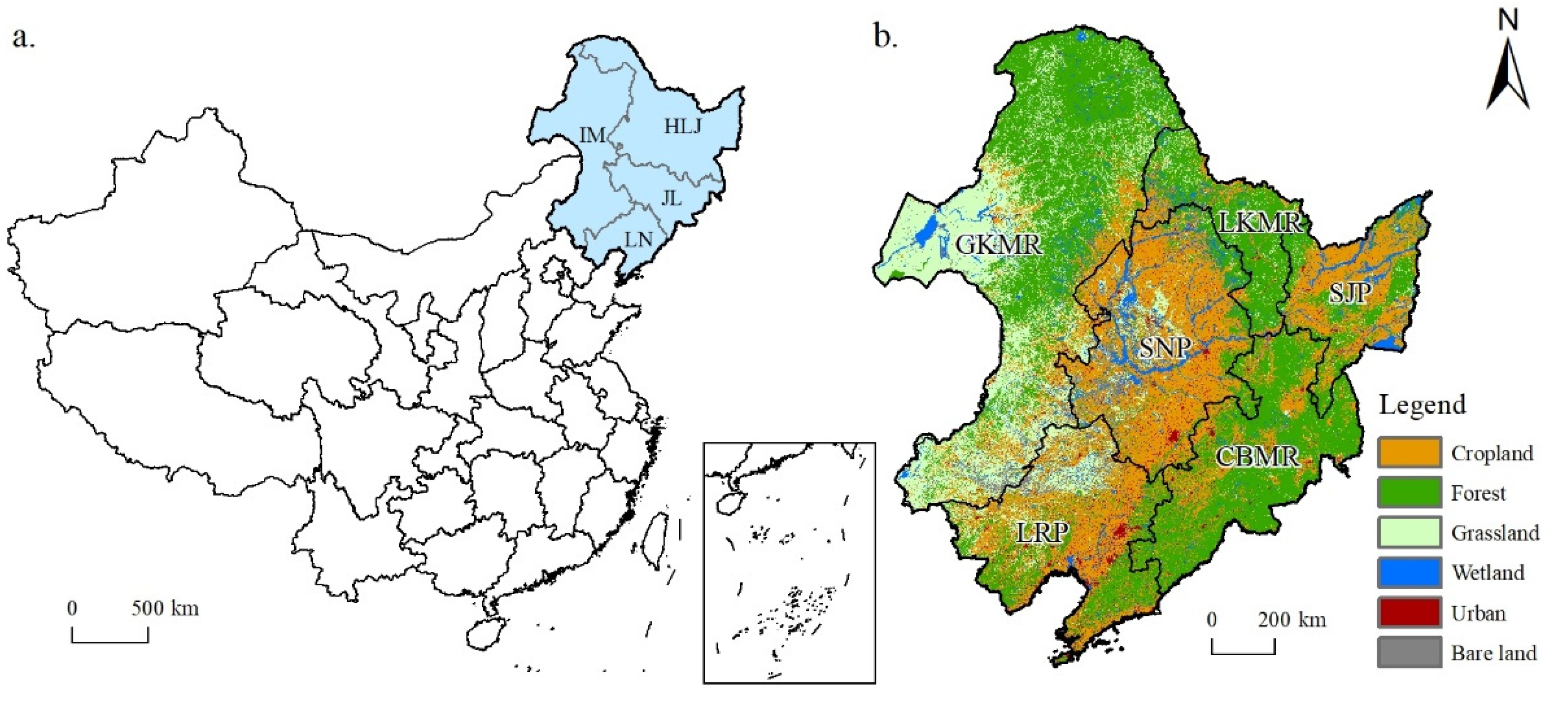
Figure 1. Location of the study area (a) and the geographic sub-regions map with land use/cover details of Northeast China in 2020 (b).
Remotesensing 15 00225 g001
Figure 2. Distribution of multi-year mean soil erosion modulus in Northeast China from 2000 to 2020.
Remotesensing 15 00225 g002
Figure 3. Distribution of interannual change trend of soil erosion modulus in Northeast China from 2000 to 2020, displayed in different timespans.
Remotesensing 15 00225 g003
Figure 4. Soil erosion at light or higher degrees: (a) year-to-year change in water erosion area, (b) year-to-year change in wind erosion area, (c) change in percentage of area in the second decade (2010–2020) compared to the first decade (2000–2010).
Remotesensing 15 00225 g004
Figure 5. Year-by-year changes of water erosion (ac) and wind erosion (df) modulus: in different geo-graphic sub-regions (a,d), types of ecosystems (b,e), and Northeast China (c,f) from 2000 to 2020.
Remotesensing 15 00225 g005
Figure 6. Land use change (a) and the relationship between LUCC and change of soil erosion (b) in Northeast China from 2000 to 2020.
Remotesensing 15 00225 g006
Table 1. Classes of soil erosion intensity.
Erosion DegreeAverage Amount of Erosion [t/(hm−2·a−1)]
1: Slight<5
2: Light5–25
3: Moderate25–50
4: Intensive>50
Table 2. Water and wind erosion in Northeast China from 2000 to 2020, displayed in different timespans.
Types of Soil Erosion 2000–20102010–20202000–2020
Mean Erosion ModulusAmount of ErosionInterannual VariationMean Erosion ModulusAmount of ErosionInterannual VariationMean Erosion ModulusAmount of ErosionInterannual Variation
(t·hm−2)(108 t)(t·hm−2·a−1)(t·hm−2)(108 t)(t·hm−2·a−1)(t·hm−2)(108 t)(t·hm−2·a−1)
Water
erosion
Geographic sub-regionsSNP0.4690.1050.0250.5870.1310.0000.5170.1160.012
SJP0.6190.0660.0460.7960.085−0.0160.6920.0740.017
LRP3.7180.6890.0212.8580.530−0.0553.2440.601−0.066
LKMR0.3840.0340.0200.3920.035−0.0170.3730.0330.001
GKMR1.2530.5650.0161.3450.606−0.0321.2800.5770.004
CBMR2.9190.5200.4422.7000.481−0.0662.6610.4740.038
Types of ecosystemsCropland1.1780.4370.0491.1460.425−0.0181.1400.4230.002
Forest1.8430.9190.1651.5840.789−0.0471.6490.822−0.002
Grassland1.8590.432−0.0061.8740.435−0.0521.8320.426−0.007
Bare land1.7690.049−0.0362.0210.056−0.0181.8900.0520.010
Northeast China1.6041.9830.0831.5141.872−0.0321.5201.8780.001
Wind
erosion
Geographic sub-regionsSNP1.2860.288−0.0901.0770.2410.0381.1540.259−0.024
SJP0.7000.075−0.0160.5390.0580.0090.6030.065−0.012
LRP2.1130.392−0.1471.1970.222−0.0451.5910.295−0.089
LKMR0.2620.023−0.0240.2310.0210.0060.2390.021−0.005
GKMR1.5720.709−0.0671.5120.6820.0671.5130.682−0.006
CBMR0.4370.078−0.0060.3150.056−0.0070.3670.066−0.009
Types of ecosystemsCropland1.1460.425−0.0700.8430.3120.0110.9640.357−0.030
Forest0.4310.215−0.0200.3250.162−0.0020.3690.184−0.010
Grassland2.4460.568−0.1082.2510.5230.0912.3020.535−0.019
Bare land4.8080.132−0.3383.4480.0950.0703.9850.110−0.133
Northeast China1.2701.571−0.0671.0391.2850.0251.1261.393−0.023
Table 3. Area percentage (%) of different degrees of water and wind erosion in Northeast China, displayed in different timespans.
Types of Erosion 2000–20102010–20202000–2020
SlightLightModerateIntensiveSlightLightModerateIntensiveSlightLightModerateIntensive
Water
erosion
Geographic sub-regionsSNP97.0042.9780.0130.00595.3574.5960.0350.01196.3713.5990.0230.007
SJP93.2126.7600.0180.01090.7289.2030.0500.01992.2297.7260.0310.014
LRP60.99337.4411.3370.22865.39033.7280.6930.18962.89336.0230.8920.192
LKMR98.1001.8800.0130.00797.9981.9760.0170.00998.2821.6950.0150.008
GKMR86.25513.3500.3300.06585.28514.2400.3810.09485.94913.6380.3380.076
CBMR68.82529.8881.1080.17966.90732.2410.7060.14568.98130.1520.7280.139
Types of ecosystemsCropland87.31212.3820.2660.04086.91412.8710.1840.03187.28412.4800.2050.031
Forest80.36319.0620.5240.05180.35019.3200.2880.04280.83218.8120.3180.038
Grassland80.88318.2270.7590.13179.99519.1850.6740.14580.55018.6550.6690.126
Bare land84.62414.3810.7290.26782.16016.6690.7930.37883.38115.5520.7450.323
Northeast China83.34216.0870.4860.08682.84716.7090.3570.08883.35016.2000.3700.080
Wind
erosion
Geographic sub-regionsSNP83.99215.9710.0330.00389.30410.6780.0170.00287.18612.7970.0150.001
SJP97.2682.7320.0000.00097.5692.4310.0000.00097.6642.3360.0000.000
LRP67.67332.1130.2040.01087.62812.3110.0600.00180.20719.6460.1420.005
LKMR99.6140.3860.0000.00099.5400.4600.0000.00099.5960.4040.0000.000
GKMR76.94422.9750.0740.00681.04418.8770.0700.00979.49120.4430.0590.007
CBMR98.2391.7590.0010.00098.8361.1630.0000.00098.5711.4280.0010.000
Types of ecosystemsCropland86.72313.2710.0060.00195.5254.4720.0030.00092.6607.3360.0030.000
Forest97.2662.7260.0070.00198.5431.4440.0120.00198.1041.8860.0080.001
Grassland59.16640.8110.0200.00267.02932.9370.0310.00363.73836.2400.0200.002
Bare land37.31961.8340.7980.04954.55844.9250.4350.08246.59652.8700.4690.065
Northeast China83.24716.6840.0640.00488.80711.1510.0380.00486.71513.2350.0460.004
Disclaimer/Publisher’s Note: The statements, opinions and data contained in all publications are solely those of the individual author(s) and contributor(s) and not of MDPI and/or the editor(s). MDPI and/or the editor(s) disclaim responsibility for any injury to people or property resulting from any ideas, methods, instructions or products referred to in the content.