
Unmanned Aerial Vehicle (UAV) Remote Sensing in Grassland Ecosystem Monitoring: A Systematic Review

Abstract
:
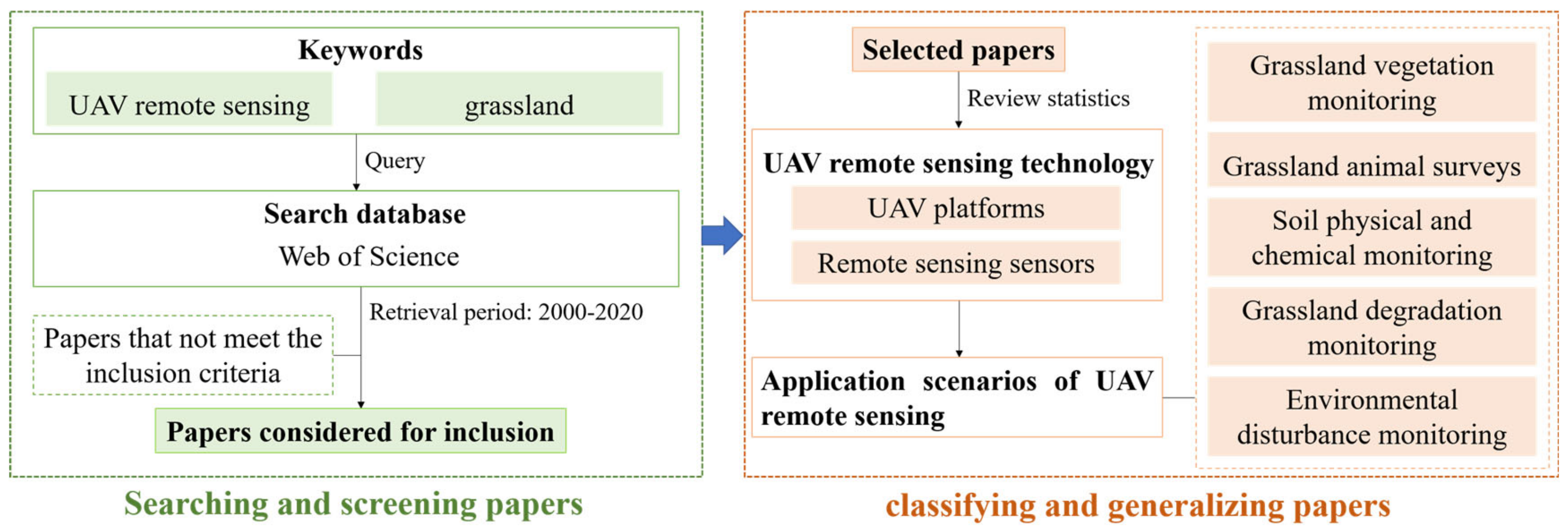
1. Introduction
2. UAV Remote Sensing Technology and Grassland Ecosystem
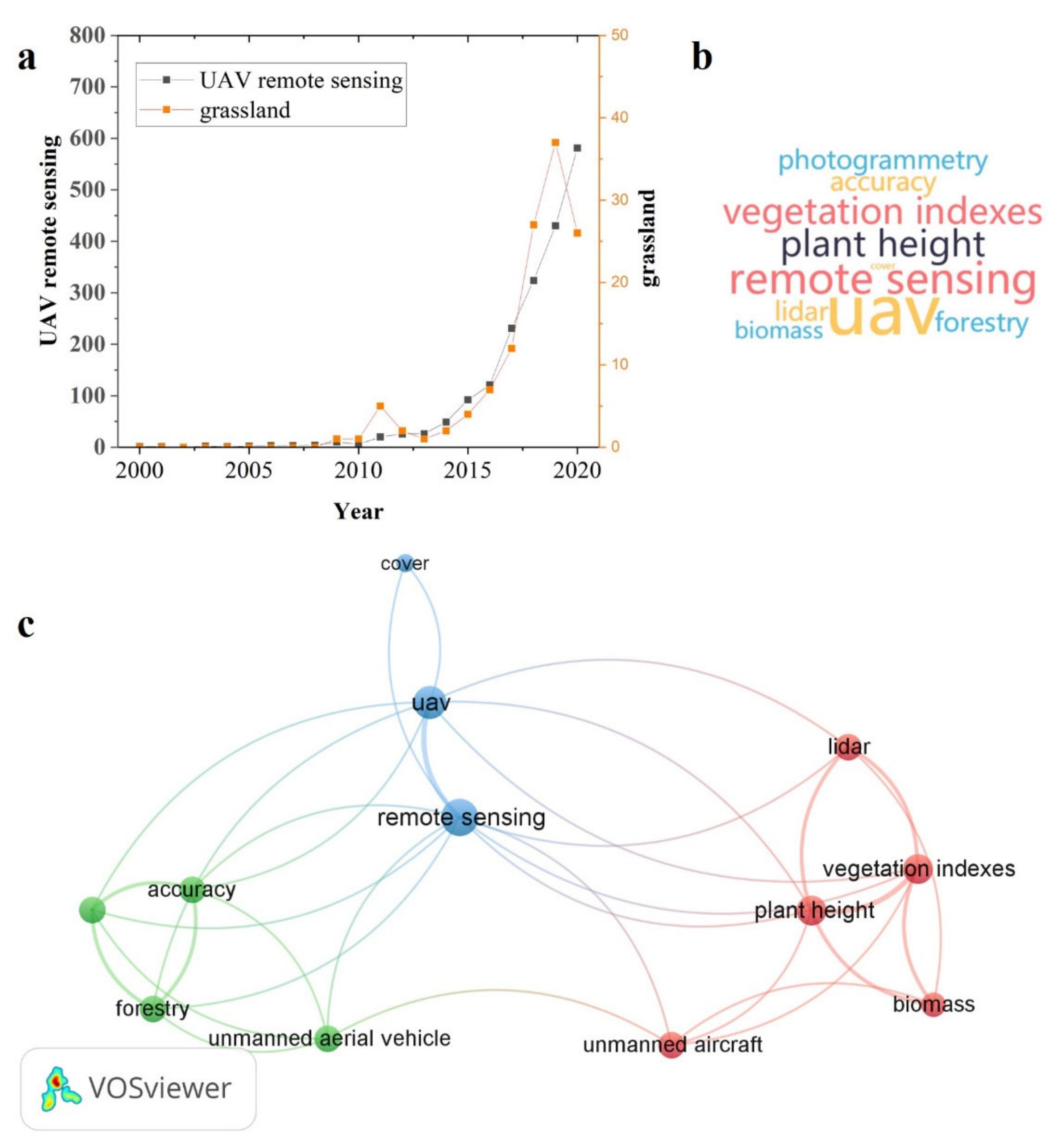
2.1. Development Trends and Research Hotspots
2.2. UAV Platforms and Sensors
3. Application of UAV Remote Sensing in Grassland Ecosystem Monitoring
3.1. Grassland Vegetation Monitoring
3.1.1. Vegetation Species Survey
3.1.2. Vegetation Parameter Inversion
3.1.3. Forage Quality Assessment
3.1.4. Biodiversity Monitoring
3.2. Grassland Animal Surveys
3.2.1. Wildlife Protection
3.2.2. Pasture Livestock Management
3.2.3. Songbird Nest Location
3.3. Soil Physical and Chemical Monitoring
3.3.1. Soil Moisture Content Monitoring
3.3.2. Soil Nutrient Content Monitoring
3.4. Grassland Degradation Monitoring
3.4.1. Vegetation Degradation Monitoring
3.4.2. Monitoring of the Shrub Encroachment Process on Grassland
3.4.3. Soil Salinization Monitoring
3.5. Environmental Disturbance Monitoring
3.5.1. Grassland Rodent Monitoring
3.5.2. Fire Monitoring and Early Warning
4. Summary and Prospects
4.1. Limitations and Challenges of UAV Applications
- (1)
- UAV remote sensing technology has certain limitations. In terms of platforms, the endurance of UAVs is relatively limited, their flight stability is not strong enough in areas with large terrain fluctuations and the lack of flight altitude limits the image size. In terms of sensors, hyperspectral or LiDAR sensors are still relatively expensive, which limits the expansion of applications to a certain extent. In terms of data integration, UAVs are often equipped with a single sensor, while multisensor integration is beneficial to improve monitoring accuracy and efficiency. In terms of data processing, the technology of mass data processing needs to be improved due to the rich structure and variety of data obtained.
- (2)
- The application scenarios of UAV remote sensing in grassland ecosystem monitoring need to be expanded and deepened. At present, the application of UAV remote sensing in grassland ecosystem monitoring is mainly vegetation monitoring, but its application in animal investigation and soil physical and chemical monitoring is still limited. Moreover, the application scenarios need to be deepened. For example, at present, in the monitoring of grassland soil physical and chemical properties using UAV remote sensing, most studies have focused on the estimation of physical and chemical properties of surface soil, which needs further research. It is also conducive to promoting the technological progress of remote sensing science.
- (3)
- The combination of UAV remote sensing with ground data and satellite data needs to be strengthened. At present, most studies at home and abroad have focused on the integrated modelling of UAV remote sensing data and measured ground data, while there have been few studies on the fusion of UAV remote sensing data and satellite remote sensing data. In fact, UAV remote sensing is more suitable for monitoring small- and medium-sized regions. Only when it is combined with satellite remote sensing data can regional and even global grassland ecosystems be monitored, and a three-dimensional grassland ecological environmental monitoring perception system can be formed.
- (4)
- The correlation between the scientific research of UAV remote sensing monitoring and practical decision making of grassland management is insufficient. At present, the work of scholars at home and abroad have mainly focused on the research of UAV remote sensing monitoring technology, and the research supporting grassland management decisions needs to be strengthened. For example, on the basis of grassland vegetation monitoring and animal surveys, it is necessary to explore suitable regional sustainable grassland management schemes from the perspective of livestock balance. Moreover, it is necessary to deepen the application research of UAV remote sensing real-time monitoring advantages in grassland management.
4.2. Future Directions
- (1)
- UAV remote sensing technology will be further improved and developed in the direction of precision and intelligence. The endurance, stability, flight height and other performance parameters of UAV platforms will be significantly improved, and the development of integrated modes such as self-networking can expand the effective monitoring range of UAV remote sensing. The cost of sensors can be reduced, and sensors can develop towards the integration of "radar point cloud" + "hyperspectral" multisensors. Machine learning gradually will become an important technical means to provide a technical basis for automatic processing and analysis of massive monitoring data [101].
- (2)
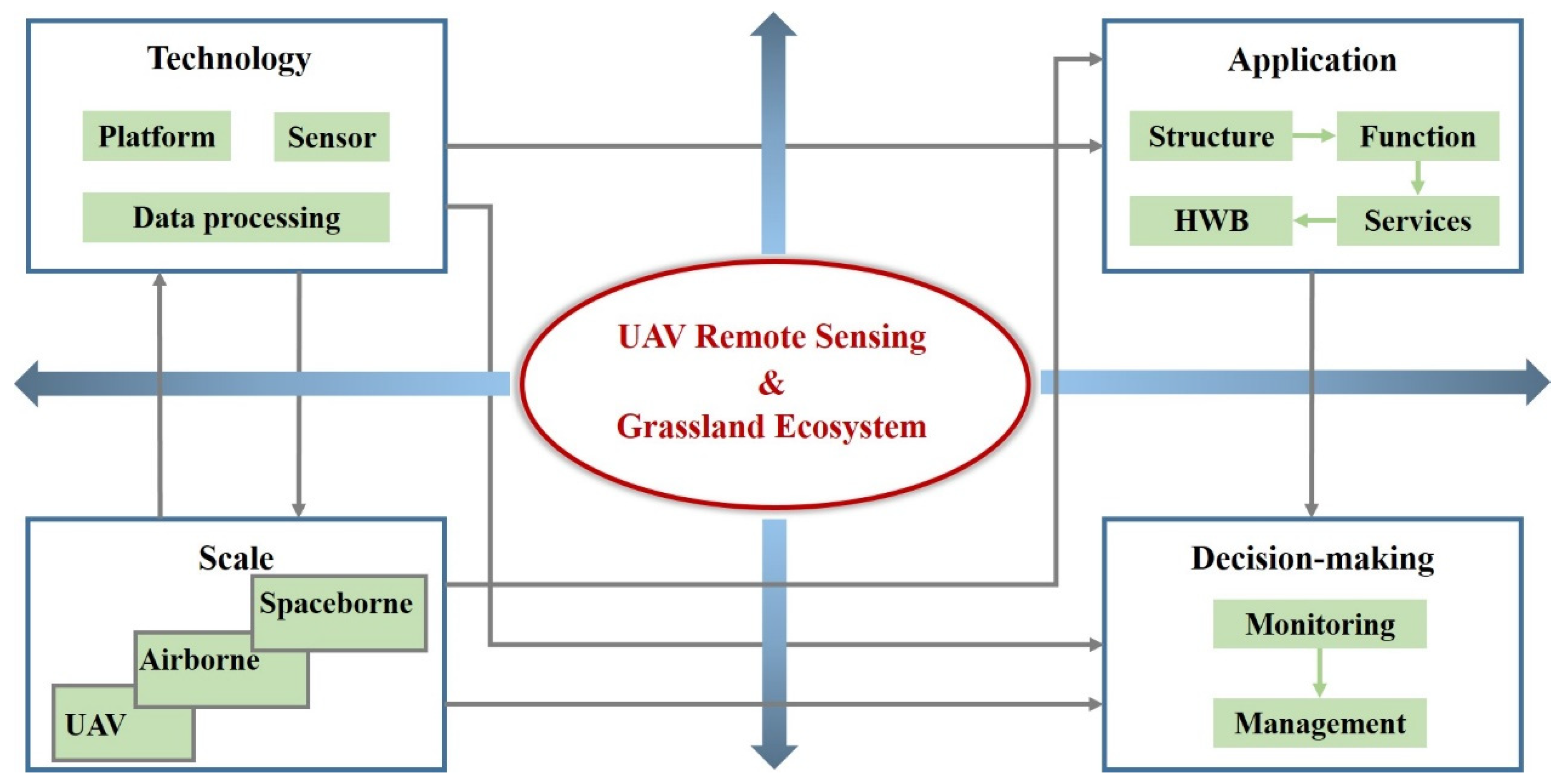
- UAV remote sensing can provide important technical support for the study of the combined relationship of "structure–process (function)–service–human well-being" in grassland ecosystems. The monitoring ability of UAV remote sensing will be significantly improved, which means it can meet the needs of fine monitoring of grassland structural properties, including the following: vegetation types, height and species richness; help to monitoring grassland process (function), such as nutrient change and forage production; provide sufficient data for accurate assessment of ecosystem services, such as the net primary production and soil conservation; and ultimately improve human well-being through scientific management of grasslands [102,103,104].
- (3)
- A space–sky–terrestrial integrated monitoring network of “satellite remote sensing–low-altitude remote sensing–ground monitoring” will form and promote the continuous expansion of the space monitoring scale. UAV remote sensing will be more closely integrated with satellite remote sensing and traditional ground monitoring. Thus, the space–sky–terrestrial integrated monitoring network will form to meet the application requirements of more scenes and develop towards multiscale, multilevel, precision and regional monitoring, opening up new development space for the precision and information management of grassland [105,106,107].
- (4)
- The decision-making support of UAV remote sensing for grassland management will be enhanced. Massive monitoring data of grassland ecosystems can be obtained by UAV remote sensing, and a decision model can be established based on the monitoring database to further guide grassland management [108]. With the development of UAV remote sensing technology, real-time monitoring systems of pastures based on UAVs can realize analysis and decision making through video streams and guide the scientific management of pastures [80].
5. Conclusions
Author Contributions
Funding
Institutional Review Board Statement
Informed Consent Statement
Data Availability Statement
Conflicts of Interest
References
- Lyu, X.; Li, X.; Dang, D.; Dou, H.; Xuan, X.; Liu, S.; Li, M.; Gong, J. A new method for grassland degradation monitoring by vegetation species composition using hyperspectral remote sensing. Ecol. Indic. 2020, 114, 106310. [Google Scholar] [CrossRef]
- Balasubramanian, D.; Zhou, W.; Ji, H.; Grace, J.; Bai, X.; Song, Q.; Liu, Y.; Sha, L.; Fei, X.; Zhang, X.; et al. Environmental and management controls of soil carbon storage in grasslands of southwestern China. J. Environ. Manag. 2020, 254, 109810. [Google Scholar] [CrossRef]
- Villoslada Peciña, M.; Ward, R.D.; Bunce, R.G.H.; Sepp, K.; Kuusemets, V.; Luuk, O. Country-scale mapping of ecosystem services provided by semi-natural grasslands. Sci. Total Environ. 2019, 661, 212–225. [Google Scholar] [CrossRef] [PubMed]
- Al-Yaari, A.; Wigneron, J.P.; Dorigo, W.; Colliander, A.; Pellarin, T.; Hahn, S.; Mialon, A.; Richaume, P.; Fernandez-Moran, R.; Fan, L.; et al. Assessment and inter-comparison of recently developed/reprocessed microwave satellite soil moisture products using ISMN ground-based measurements. Remote Sens. Environ. 2019, 224, 289–303. [Google Scholar] [CrossRef]
- Joiner, J.; Guanter, L.; Lindstrot, R.; Voigt, M.; Vasilkov, A.P.; Middleton, E.M.; Huemmrich, K.F.; Yoshida, Y.; Frankenberg, C. Global monitoring of terrestrial chlorophyll fluorescence from moderate-spectral-resolution near-infrared satellite measurements: Methodology, simulations, and application to GOME-2. Atmos. Meas. Tech. 2013, 6, 2803–2823. [Google Scholar] [CrossRef] [Green Version]
- Li, C.; Han, W.; Peng, M. Improving the spatial and temporal estimating of daytime variation in maize net primary production using unmanned aerial vehicle-based remote sensing. Int. J. Appl. Earth Obs. Geoinf. 2021, 103, 102467. [Google Scholar] [CrossRef]
- Gao, F.; Anderson, M.C.; Zhang, X.Y.; Yang, Z.W.; Alfieri, J.G.; Kustas, W.P.; Mueller, R.; Johnson, D.M.; Prueger, J.H. Toward mapping crop progress at field scales through fusion of Landsat and MODIS imagery. Remote Sens. Environ. 2017, 188, 9–25. [Google Scholar] [CrossRef] [Green Version]
- Feng, L.; Chen, S.; Zhang, C.; Zhang, Y.; He, Y. A comprehensive review on recent applications of unmanned aerial vehicle remote sensing with various sensors for high-throughput plant phenotyping. Comput. Electron. Agric. 2021, 182, 106033. [Google Scholar] [CrossRef]
- Isokangas, E.; Davids, C.; Kujala, K.; Rauhala, A.; Ronkanen, A.-K.; Rossi, P.M. Combining unmanned aerial vehicle-based remote sensing and stable water isotope analysis to monitor treatment peatlands of mining areas. Ecol. Eng. 2019, 133, 137–147. [Google Scholar] [CrossRef]
- Zheng, H.; Zhou, X.; He, J.; Yao, X.; Cheng, T.; Zhu, Y.; Cao, W.; Tian, Y. Early season detection of rice plants using RGB, NIR-G-B and multispectral images from unmanned aerial vehicle (UAV). Comput. Electron. Agric. 2020, 169, 105223. [Google Scholar] [CrossRef]
- Qin, R.J. An Object-Based Hierarchical Method for Change Detection Using Unmanned Aerial Vehicle Images. Remote Sens. 2014, 6, 7911–7932. [Google Scholar] [CrossRef] [Green Version]
- Honkavaara, E.; Saari, H.; Kaivosoja, J.; Polonen, I.; Hakala, T.; Litkey, P.; Makynen, J.; Pesonen, L. Processing and Assessment of Spectrometric, Stereoscopic Imagery Collected Using a Lightweight UAV Spectral Camera for Precision Agriculture. Remote Sens. 2013, 5, 5006–5039. [Google Scholar] [CrossRef] [Green Version]
- Adao, T.; Hruska, J.; Padua, L.; Bessa, J.; Peres, E.; Morais, R.; Sousa, J.J. Hyperspectral Imaging: A Review on UAV-Based Sensors, Data Processing and Applications for Agriculture and Forestry. Remote Sens. 2017, 9, 1110. [Google Scholar] [CrossRef] [Green Version]
- Reis, B.P.; Martins, S.V.; Fernandes Filho, E.I.; Sarcinelli, T.S.; Gleriani, J.M.; Leite, H.G.; Halassy, M. Forest restoration monitoring through digital processing of high resolution images. Ecol. Eng. 2019, 127, 178–186. [Google Scholar] [CrossRef] [Green Version]
- Libran-Embid, F.; Klaus, F.; Tscharntke, T.; Grass, I. Unmanned aerial vehicles for biodiversity-friendly agricultural landscapes-A systematic review. Sci. Total Environ. 2020, 732, 139204. [Google Scholar] [CrossRef]
- Pajares, G. Overview and Current Status of Remote Sensing Applications Based on Unmanned Aerial Vehicles (UAVs). Photogramm. Eng. Remote Sens. 2015, 81, 281–329. [Google Scholar] [CrossRef] [Green Version]
- Gao, J.T.; Sun, F.D.; Huo, F.; Zhang, L.B.; Zhou, S.; Yang, T.Y.; Dabian, Z.X. Application and evaluation of unmanned aerial vehicle remote sensing in grassland animal and plant monitoring. Acta Agrestia Sin. 2021, 29, 1–9. [Google Scholar]
- Senf, C.; Seidl, R.; Hostert, P. Remote sensing of forest insect disturbances: Current state and future directions. Int. J. Appl. Earth Obs. Geoinf. 2017, 60, 49–60. [Google Scholar] [CrossRef] [PubMed] [Green Version]
- Zheng, Z.J.; Du, S.S.; Taubenböck, H.; Zhang, X.Y. Remote sensing techniques in the investigation of aeolian sand dunes: A review of recent advances. Remote Sens. Environ. 2022, 271, 112913. [Google Scholar] [CrossRef]
- Modak, N.M.; Sinha, S.; Raj, A.; Panda, S.; Merigó, J.M.; Lopes de Sousa Jabbour, A.B. Corporate social responsibility and supply chain management: Framing and pushing forward the debate. J. Clean. Prod. 2020, 273, 122981. [Google Scholar] [CrossRef]
- Laengle, S.; Merigo, J.M.; Modak, N.M.; Yang, J.B. Bibliometrics in operations research and management science: A university analysis. Ann. Oper. Res. 2020, 294, 769–813. [Google Scholar] [CrossRef]
- Radoglou-Grammatikis, P.; Sarigiannidis, P.; Lagkas, T.; Moscholios, I. A compilation of UAV applications for precision agriculture. Comput. Netw. 2020, 172, 107148. [Google Scholar] [CrossRef]
- Lu, B.; He, Y.H. Species classification using Unmanned Aerial Vehicle (UAV)-acquired high spatial resolution imagery in a heterogeneous grassland. ISPRS J. Photogramm. 2017, 128, 73–85. [Google Scholar] [CrossRef]
- Awais, M.; Li, W.; Cheema, M.J.M.; Hussain, S.; AlGarni, T.S.; Liu, C.C.; Ali, A. Remotely sensed identification of canopy characteristics using UAV-based imagery under unstable environmental conditions. Environ. Technol. Innov. 2021, 22, 101465. [Google Scholar] [CrossRef]
- Wang, F.M.; Yi, Q.X.; Hu, J.H.; Xie, L.L.; Yao, X.P.; Xu, T.Y.; Zheng, J.Y. Combining spectral and textural information in UAV hyperspectral images to estimate rice grain yield. Int. J. Appl. Earth Obs. Geoinf. 2021, 102, 102397. [Google Scholar] [CrossRef]
- Bolourian, N.; Hammad, A. LiDAR-equipped UAV path planning considering potential locations of defects for bridge inspection. Automat. Constr. 2020, 117, 103250. [Google Scholar] [CrossRef]
- Meng, B.P.; Yang, Z.G.; Yu, H.Y.; Qin, Y.; Sun, Y.; Zhang, J.G.; Chen, J.J.; Wang, Z.W.; Zhang, W.; Li, M.; et al. Mapping of Kobresia pygmaea Community Based on Umanned Aerial Vehicle Technology and Gaofen Remote Sensing Data in Alpine Meadow Grassland: A Case Study in Eastern of Qinghai-Tibetan Plateau. Remote Sens. 2021, 13, 2483. [Google Scholar] [CrossRef]
- Yang, H.; Du, J. Classification of desert steppe species based on unmanned aerial vehicle hyperspectral remote sensing and continuum removal vegetation indices. Optik 2021, 247, 167877. [Google Scholar] [CrossRef]
- Sun, S.Z.; Wang, C.J.; Yin, X.J.; Wang, W.Q.; Liu, W.; Zhang, Y.; Zhao, Q.Z. Estimating aboveground biomass of natural grassland based on multispectral images of Unmanned Aerial Vehicles. J. Remote Sens. 2018, 22, 848–856. [Google Scholar]
- Pi, W.; Du, J.; Bi, Y.; Gao, X.; Zhu, X. 3D-CNN based UAV hyperspectral imagery for grassland degradation indicator ground object classification research. Ecol. Inform. 2021, 62, 101278. [Google Scholar] [CrossRef]
- Wijesingha, J.; Astor, T.; Schulze-Bruninghoff, D.; Wengert, M.; Wachendorf, M. Predicting Forage Quality of Grasslands Using UAV-Borne Imaging Spectroscopy. Remote Sens. 2020, 12, 126. [Google Scholar] [CrossRef] [Green Version]
- Zhang, X.; Bao, Y.H.; Wang, D.L.; Xin, X.P.; Ding, L.; Xu, D.W.; Hou, L.L.; Shen, J. Using UAV LiDAR to Extract Vegetation Parameters of Inner Mongolian Grassland. Remote Sens. 2021, 13, 656. [Google Scholar] [CrossRef]
- Wang, D.; Xin, X.; Shao, Q.; Brolly, M.; Zhu, Z.; Chen, J. Modeling Aboveground Biomass in Hulunber Grassland Ecosystem by Using Unmanned Aerial Vehicle Discrete Lidar. Sensors 2017, 17, 180. [Google Scholar] [CrossRef] [PubMed] [Green Version]
- Guo, Q.H.; Wu, F.F.; Hu, T.Y.; Chen, L.H.; Liu, J.; Zhao, X.Q.; Gao, S.; Pang, S.X. Perspectives and prospects of unmanned aerial vehicle in remote sensing monitoring of biodiversity. Biodivers. Sci. 2016, 24, 1267–1278. [Google Scholar] [CrossRef]
- Schmidt, J.; Fassnacht, F.E.; Neff, C.; Lausch, A.; Kleinschmit, B.; Förster, M.; Schmidtlein, S. Adapting a Natura 2000 field guideline for a remote sensing-based assessment of heathland conservation status. Int. J. Appl. Earth Obs. Geoinf. 2017, 60, 61–71. [Google Scholar] [CrossRef]
- Yuan, G.; Wang, Y.J.; Zhao, F.; Wang, T.; Zhang, L.X.; Hao, M.; Yan, S.Y.; Dang, L.B.; Peng, B. Accuracy assessment and scale effect investigation of UAV thermography for underground coal fire surface temperature monitoring. Int. J. Appl. Earth Obs. Geoinf. 2021, 102, 102426. [Google Scholar] [CrossRef]
- Tang, L.N.; Shao, G.F. Drone remote sensing for forestry research and practices. J. For. Res. 2015, 26, 791–797. [Google Scholar] [CrossRef]
- Jin, X.L.; Liu, S.Y.; Baret, F.; Hemerle, M.; Comar, A. Estimates of plant density of wheat crops at emergence from very low altitude UAV imagery. Remote Sens. Environ. 2017, 198, 105–114. [Google Scholar] [CrossRef] [Green Version]
- Rey, N.; Volpi, M.; Joost, S.; Tuia, D. Detecting animals in African Savanna with UAVs and the crowds. Remote Sens. Environ. 2017, 200, 341–351. [Google Scholar] [CrossRef] [Green Version]
- Webster, C.; Westoby, M.; Rutter, N.; Jonas, T. Three-dimensional thermal characterization of forest canopies using UAV photogrammetry. Remote Sens. Environ. 2018, 209, 835–847. [Google Scholar] [CrossRef] [Green Version]
- Huang, C.; Geiger, E.L.; Van Leeuwen, W.J.D.; Marsh, S.E. Discrimination of invaded and native species sites in a semi-desert grassland using MODIS multi-temporal data. Int. J. Remote Sens. 2009, 30, 897–917. [Google Scholar] [CrossRef] [Green Version]
- Hall, K.; Johansson, L.J.; Sykes, M.T.; Reitalu, T.; Larsson, K.; Prentice, H.C. Inventorying management status and plant species richness in semi-natural grasslands using high spatial resolution imagery. Appl. Veg. Sci. 2010, 13, 221–233. [Google Scholar] [CrossRef]
- Sun, Y.; Yi, S.H.; Hou, F.J. Unmanned aerial vehicle methods makes species composition monitoring easier in grasslands. Ecol. Indic. 2018, 95, 825–830. [Google Scholar] [CrossRef]
- Lopatin, J.; Fassnacht, F.E.; Kattenborn, T.; Schmidtlein, S. Mapping plant species in mixed grassland communities using close range imaging spectroscopy. Remote Sens. Environ. 2017, 201, 12–23. [Google Scholar] [CrossRef]
- Meng, B.P.; Jinlong, G.L.; Liang, T.G.; Cui, X.; Ge, J.; Yin, J.P.; Feng, Q.S.; Xie, H.J. Modeling of Alpine Grassland Cover Based on Unmanned Aerial Vehicle Technology and Multi-Factor Methods: A Case Study in the East of Tibetan Plateau, China. Remote Sens. 2018, 10, 320. [Google Scholar] [CrossRef] [Green Version]
- Pullanagari, R.R.; Yule, I.J.; Tuohy, M.P.; Hedley, M.J.; Dynes, R.A.; King, W.M. In-field hyperspectral proximal sensing for estimating quality parameters of mixed pasture. Precis. Agric. 2012, 13, 351–369. [Google Scholar] [CrossRef]
- Safari, H.; Fricke, T.; Wachendorf, M. Determination of fibre and protein content in heterogeneous pastures using field spectroscopy and ultrasonic sward height measurements. Comput. Electron. Agric. 2016, 123, 256–263. [Google Scholar] [CrossRef]
- Hardin, P.J.; Jackson, M.W. An unmanned aerial vehicle for rangeland photography. Rangel. Ecol. Manag. 2005, 58, 439–442. [Google Scholar] [CrossRef]
- Capolupo, A.; Kooistra, L.; Berendonk, C.; Boccia, L.; Suomalainen, J. Estimating Plant Traits of Grasslands from UAV-Acquired Hyperspectral Images: A Comparison of Statistical Approaches. ISPRS Int. J. Geo-Inf. 2015, 4, 2792–2820. [Google Scholar] [CrossRef]
- Nasi, R.; Viljanen, N.; Kaivosoja, J.; Alhonoja, K.; Hakala, T.; Markelin, L.; Honkavaara, E. Estimating Biomass and Nitrogen Amount of Barley and Grass Using UAV and Aircraft Based Spectral and Photogrammetric 3D Features. Remote Sens. 2018, 10, 1082. [Google Scholar] [CrossRef] [Green Version]
- Oliveira, R.A.; Näsi, R.; Niemeläinen, O.; Nyholm, L.; Alhonoja, K.; Kaivosoja, J.; Jauhiainen, L.; Viljanen, N.; Nezami, S.; Markelin, L.; et al. Machine learning estimators for the quantity and quality of grass swards used for silage production using drone-based imaging spectrometry and photogrammetry. Remote Sens. Environ. 2020, 246, 111830. [Google Scholar] [CrossRef]
- Castro, P.A.; Garbulsky, M.F. Spectral normalized indices related with forage quality in temperate grasses: Scaling up from leaves to canopies. Int. J. Remote Sens. 2018, 39, 3138–3163. [Google Scholar] [CrossRef]
- Pullanagari, R.R.; Kereszturi, G.; Yule, I. Integrating Airborne Hyperspectral, Topographic, and Soil Data for Estimating Pasture Quality Using Recursive Feature Elimination with Random Forest Regression. Remote Sens. 2018, 10, 1117. [Google Scholar] [CrossRef] [Green Version]
- Gholizadeh, H.; Gamon, J.A.; Townsend, P.A.; Zygielbaum, A.I.; Helzer, C.J.; Hmimina, G.Y.; Yu, R.; Moore, R.M.; Schweiger, A.K.; Cavender-Bares, J. Detecting prairie biodiversity with airborne remote sensing. Remote Sens. Environ. 2019, 221, 38–49. [Google Scholar] [CrossRef]
- De Bello, F.; Leps, J.; Sebastia, M.T. Variations in species and functional plant diversity along climatic and grazing gradients. Ecography 2006, 29, 801–810. [Google Scholar] [CrossRef]
- Spellerberg, I.F.; Fedor, P.J. A tribute to Claude Shannon (1916–2001) and a plea for more rigorous use of species richness, species diversity and the ‘Shannon-Wiener’ Index. Glob. Ecol. Biogeogr. 2003, 12, 177–179. [Google Scholar] [CrossRef] [Green Version]
- Hickman, K.R.; Hartnett, D.C.; Cochran, R.C.; Owensby, C.E. Grazing management effects on plant species diversity in tallgrass prairie. J. Range Manag. 2004, 57, 58–65. [Google Scholar] [CrossRef]
- Mulero-Pazmany, M.; Barasona, J.A.; Acevedo, P.; Vicente, J.; Negro, J.J. Unmanned Aircraft Systems complement biologging in spatial ecology studies. Ecol. Evol. 2015, 5, 4808–4818. [Google Scholar] [CrossRef] [PubMed] [Green Version]
- Linchant, J.; Lisein, J.; Semeki, J.; Lejeune, P.; Vermeulen, C. Are unmanned aircraft systems (UASs) the future of wildlife monitoring? A review of accomplishments and challenges. Mammal Rev. 2015, 45, 239–252. [Google Scholar] [CrossRef]
- Jones, G.P.; Pearlstine, L.G.; Percival, H.F. An assessment of small unmanned aerial vehicles for wildlife research. Wildl. Soc. Bull. 2006, 34, 750–758. [Google Scholar] [CrossRef]
- Shao, Q.Q.; Guo, X.J.; Li, Y.Z.; Wang, Y.C.; Wang, D.L.; Liu, J.Y.; Fan, J.W.; Yang, F. Using UAV remote sensing to analyze the population and distribution of large wild herbivores. J. Remote Sens. 2018, 22, 497–507. [Google Scholar]
- Gonzalez, L.F.; Montes, G.A.; Puig, E.; Johnson, S.; Mengersen, K.; Gaston, K.J. Unmanned Aerial Vehicles (UAVs) and Artificial Intelligence Revolutionizing Wildlife Monitoring and Conservation. Sensors 2016, 16, 97. [Google Scholar] [CrossRef] [PubMed] [Green Version]
- Norouzzadeh, M.S.; Nguyen, A.; Kosmala, M.; Swanson, A.; Palmer, M.S.; Packer, C.; Clune, J. Automatically identifying, counting, and describing wild animals in camera-trap images with deep learning. Proc. Natl. Acad. Sci. USA 2018, 115, E5716–E5725. [Google Scholar] [CrossRef] [PubMed] [Green Version]
- Sun, Y.; Yi, S.H.; Hou, F.J.; Luo, D.W.; Hu, J.Q.; Zhou, Z.Y. Quantifying the Dynamics of Livestock Distribution by Unmanned Aerial Vehicles (UAVs): A Case Study of Yak Grazing at the Household Scale. Rangel. Ecol. Manag. 2020, 73, 642–648. [Google Scholar] [CrossRef]
- Wang, D.L.; Liao, X.H.; Zhang, Y.J.; Cong, N.; Ye, H.P.; Shao, Q.Q.; Xin, X.P. Grassland livestock real-time detection and weight estimation based on unmanned aircraft system video streams. Chin. J. Ecol. 2021, 40, 4099–4108. [Google Scholar]
- Rango, A.; Laliberte, A.; Herrick, J.E.; Winters, C.; Havstad, K.; Steele, C.; Browning, D. Unmanned aerial vehicle-based remote sensing for rangeland assessment, monitoring, and management. J. Appl. Remote Sens. 2009, 3, 033542. [Google Scholar]
- Chi, D.; Wang, H.; Li, X.; Liu, H.; Li, X. Assessing the effects of grazing on variations of vegetation NPP in the Xilingol Grassland, China, using a grazing pressure index. Ecol. Indic. 2018, 88, 372–383. [Google Scholar] [CrossRef]
- Li, X.; Lyu, X.; Dou, H.; Dang, D.; Li, S.; Li, X.; Li, M.; Xuan, X. Strengthening grazing pressure management to improve grassland ecosystem services. Glob. Ecol. Conserv. 2021, 31, e01782. [Google Scholar] [CrossRef]
- Morrison, M.L. Bird Populations as Indicators of Environmental Change. In Current Ornithology; Johnston, R.F., Ed.; Springer: Boston, MA, USA, 1986; pp. 429–451. [Google Scholar]
- Dion, N.; Hobson, K.A.; Lariviere, S. Interactive effects of vegetation and predators on the success of natural and simulated nests of grassland songbirds. Condor 2000, 102, 629–634. [Google Scholar] [CrossRef]
- McClelland, G.T.W.; Bond, A.L.; Sardana, A.; Glass, T. Rapid Population Estimate of a Surface-Nesting Seabird on a Remote Island Using a Low-Cost Unmanned Aerial Vehicle. Mar. Ornithol. 2016, 44, 215–220. [Google Scholar]
- Wilson, A.M.; Barr, J.; Zagorski, M. The feasibility of counting songbirds using unmanned aerial vehicles. Auk 2017, 134, 350–362. [Google Scholar] [CrossRef]
- Galligan, E.W.; Bakken, G.S.; Lima, S.L. Using a thermographic imager to find nests of grassland birds. Wildl. Soc. Bull. 2003, 31, 865–869. [Google Scholar]
- Scholten, C.N.; Kamphuis, A.J.; Vredevoogd, K.J.; Lee-Strydhorst, K.G.; Atma, J.L.; Shea, C.B.; Lamberg, O.N.; Proppe, D.S. Real-time thermal imagery from an unmanned aerial vehicle can locate ground nests of a grassland songbird at rates similar to traditional methods. Biol. Conserv. 2019, 233, 241–246. [Google Scholar] [CrossRef]
- Aide, T.M.; Corrada-Bravo, C.; Campos-Cerqueira, M.; Milan, C.; Vega, G.; Alvarez, R. Real-time bioacoustics monitoring and automated species identification. PeerJ 2013, 1, e103. [Google Scholar] [CrossRef] [PubMed] [Green Version]
- Pieri, D.; Abrams, M. ASTER observations of thermal anomalies preceding the April 2003 eruption of Chikurachki volcano, Kurile Islands, Russia. Remote Sens. Environ. 2005, 99, 84–94. [Google Scholar] [CrossRef]
- Ge, X.; Wang, J.; Ding, J.; Cao, X.; Zhang, Z.; Jie, L.; Li, X. Combining UAV-based hyperspectral imagery and machine learning algorithms for soil moisture content monitoring. PeerJ 2019, 7, e6926. [Google Scholar] [CrossRef]
- Zhang, W.; Yi, S.H.; Qin, Y.; Sun, Y.; Shangguan, D.H.; Meng, B.P.; Li, M.; Zhang, J.G. Effects of Patchiness on Surface Soil Moisture of Alpine Meadow on the Northeastern Qinghai-Tibetan Plateau: Implications for Grassland Restoration. Remote Sens. 2020, 12, 4121. [Google Scholar] [CrossRef]
- Lu, F.S.; Sun, Y.; Hou, F.J. Using UAV Visible Images to Estimate the Soil Moisture of Steppe. Water 2020, 12, 2334. [Google Scholar] [CrossRef]
- Sankey, T.T.; Leonard, J.M.; Moore, M.M. Unmanned Aerial Vehicle−Based Rangeland Monitoring: Examining a Century of Vegetation Changes. Rangel. Ecol. Manag. 2019, 72, 858–863. [Google Scholar] [CrossRef]
- Pluer, E.G.M.; Robinson, D.T.; Meinen, B.U.; Macrae, M.L. Pairing soil sampling with very-high resolution UAV imagery: An examination of drivers of soil and nutrient movement and agricultural productivity in southern Ontario. Geoderma 2020, 379, 114630. [Google Scholar] [CrossRef]
- Li, Z.F.; Li, X.B.; Chen, L.H.; Li, R.H.; Deng, F.; Zhang, M.; Wen, L.Q. Carbon flux and soil organic carbon content and density of different community types in a typical steppe ecoregion of Xilin Gol in inner Mongolia, China. J. Arid Environ. 2020, 178, 104155. [Google Scholar] [CrossRef]
- Lyu, X.; Li, X.; Gong, J.; Wang, H.; Dang, D.; Dou, H.; Li, S.; Liu, S. Comprehensive grassland degradation monitoring by remote sensing in Xilinhot, Inner Mongolia, China. Sustainability 2020, 12, 3682. [Google Scholar] [CrossRef]
- Li, H.; Shen, H.H.; Chen, L.Y.; Liu, T.Y.; Hu, H.F.; Zhao, X.; Zhou, L.H.; Zhang, P.J.; Fang, J.Y. Effects of shrub encroachment on soil organic carbon in global grasslands. Sci. Rep. 2016, 6, 28974. [Google Scholar] [CrossRef] [PubMed] [Green Version]
- Caracciolo, D.; Istanbulluoglu, E.; Noto, L.V.; Collins, S.L. Mechanisms of shrub encroachment into Northern Chihuahuan Desert grasslands and impacts of climate change investigated using a cellular automata model. Adv. Water Resour. 2016, 91, 46–62. [Google Scholar] [CrossRef] [Green Version]
- Li, W.; Buitenwerf, R.; Munk, M.; Amoke, I.; Bocher, P.K.; Svenning, J.C. Accelerating savanna degradation threatens the Maasai Mara socio-ecological system. Glob. Environ. Chang. 2020, 60, 102030. [Google Scholar] [CrossRef]
- Zhao, Y.J.; Liu, X.L.; Wang, Y.; Zheng, Z.Y.; Zheng, S.X.; Zhao, D.; Bai, Y.F. UAV-based individual shrub aboveground biomass estimation calibrated against terrestrial LiDAR in a shrub-encroached grassland. Int. J. Appl. Earth Obs. Geoinf. 2021, 101, 102358. [Google Scholar] [CrossRef]
- Prošek, J.; Šímová, P. UAV for mapping shrubland vegetation: Does fusion of spectral and vertical information derived from a single sensor increase the classification accuracy? Int. J. Appl. Earth Obs. Geoinf. 2019, 75, 151–162. [Google Scholar] [CrossRef]
- Pang, G.J.; Wang, T.; Liao, J.; Li, S. Quantitative Model Based on Field-Derived Spectral Characteristics to Estimate Soil Salinity in Minqin County, China. Soil Sci. Soc. Am. J. 2014, 78, 546. [Google Scholar] [CrossRef]
- Ivushkin, K.; Bartholomeus, H.; Bregt, A.K.; Pulatov, A.; Franceschini, M.H.D.; Kramer, H.; van Loo, E.N.; Jaramillo Roman, V.; Finkers, R. UAV based soil salinity assessment of cropland. Geoderma 2019, 338, 502–512. [Google Scholar] [CrossRef]
- Romero-Trigueros, C.; Nortes, P.A.; Alarcón, J.J.; Hunink, J.E.; Parra, M.; Contreras, S.; Droogers, P.; Nicolás, E. Effects of saline reclaimed waters and deficit irrigation on Citrus physiology assessed by UAV remote sensing. Agric. Water Manag. 2017, 183, 60–69. [Google Scholar] [CrossRef] [Green Version]
- Hu, J.; Peng, J.; Zhou, Y.; Xu, D.Y.; Zhao, R.Y.; Jiang, Q.S.; Fu, T.T.; Wang, F.; Shi, Z. Quantitative Estimation of Soil Salinity Using UAV-Borne Hyperspectral and Satellite Multispectral Images. Remote Sens. 2019, 11, 736. [Google Scholar] [CrossRef] [Green Version]
- Zhang, J.G.; Liu, D.W.; Meng, B.P.; Chen, J.J.; Wang, X.Y.; Jiang, H.; Yu, Y.; Yi, S.H. Using UAVs to assess the relationship between alpine meadow bare patches and disturbance by pikas in the source region of Yellow River on the Qinghai-Tibetan Plateau. Glob. Ecol. Conserv. 2021, 26, e01517. [Google Scholar] [CrossRef]
- Tang, Z.; Zhang, Y.J.; Cong, N.; Wimberly, M.; Wang, L.; Huang, K.; Li, J.X.; Zu, J.X.; Zhu, Y.X.; Chen, N. Spatial pattern of pika holes and their effects on vegetation coverage on the Tibetan Plateau: An analysis using unmanned aerial vehicle imagery. Ecol. Indic. 2019, 107, 105551. [Google Scholar] [CrossRef]
- Yi, S.H. FragMAP: A tool for long-term and cooperative monitoring and analysis of small-scale habitat fragmentation using an unmanned aerial vehicle. Int. J. Remote Sens. 2017, 38, 2686–2697. [Google Scholar] [CrossRef]
- Pérez-Cabello, F.; Montorio, R.; Alves, D.B. Remote sensing techniques to assess post-fire vegetation recovery. Curr. Opin. Environ. Sci. Health 2021, 21, 100251. [Google Scholar] [CrossRef]
- Li, Q.; Cui, J.; Jiang, W.; Jiao, Q.; Gong, L.; Zhang, J.; Shen, X. Monitoring of the Fire in Muli County on March 28, 2020, based on high temporal-spatial resolution remote sensing techniques. Nat. Hazards Res. 2021, 1, 20–31. [Google Scholar] [CrossRef]
- Cruz, H.; Eckert, M.; Meneses, J.; Martinez, J.F. Efficient Forest Fire Detection Index for Application in Unmanned Aerial Systems (UASs). Sensors 2016, 16, 893. [Google Scholar] [CrossRef] [Green Version]
- Liu, X.P.; Zhang, G.Q.; Lu, J.; Zhang, J.Q. Risk assessment using transfer learning for grassland fires. Agric. For. Meteorol. 2019, 269, 102–111. [Google Scholar] [CrossRef]
- Yuan, C.; Zhang, Y.M.; Liu, Z.X. A survey on technologies for automatic forest fire monitoring, detection, and fighting using unmanned aerial vehicles and remote sensing techniques. Can. J. For. Res. 2015, 45, 783–792. [Google Scholar] [CrossRef]
- Osco, L.P.; Marcato Junior, J.; Marques Ramos, A.P.; de Castro Jorge, L.A.; Fatholahi, S.N.; de Andrade Silva, J.; Matsubara, E.T.; Pistori, H.; Gonçalves, W.N.; Li, J. A review on deep learning in UAV remote sensing. Int. J. Appl. Earth Obs. Geoinf. 2021, 102, 102456. [Google Scholar] [CrossRef]
- Tilman, D. Causes, consequences and ethics of biodiversity. Nature 2000, 405, 208–211. [Google Scholar] [CrossRef]
- Chapin, F.S.; Zavaleta, E.S.; Eviner, V.T.; Naylor, R.L.; Vitousek, P.M.; Reynolds, H.L.; Hooper, D.U.; Lavorel, S.; Sala, O.E.; Hobbie, S.E.; et al. Consequences of changing biodiversity. Nature 2000, 405, 234–242. [Google Scholar] [CrossRef] [PubMed]
- Hou, L.; Xia, F.; Chen, Q.; Huang, J.; He, Y.; Rose, N.; Rozelle, S. Grassland ecological compensation policy in China improves grassland quality and increases herders’ income. Nat. Commun. 2021, 12, 4683. [Google Scholar] [CrossRef] [PubMed]
- Anderson, K.; Gaston, K.J. Lightweight unmanned aerial vehicles will revolutionize spatial ecology. Front. Ecol. Environ. 2013, 11, 138–146. [Google Scholar] [CrossRef] [Green Version]
- Obermeier, W.A.; Lehnert, L.W.; Pohl, M.J.; Makowski Gianonni, S.; Silva, B.; Seibert, R.; Laser, H.; Moser, G.; Müller, C.; Luterbacher, J.; et al. Grassland ecosystem services in a changing environment: The potential of hyperspectral monitoring. Remote Sens. Environ. 2019, 232, 111273. [Google Scholar] [CrossRef]
- Sankey, J.B.; Sankey, T.T.; Li, J.; Ravi, S.; Wang, G.; Caster, J.; Kasprak, A. Quantifying plant-soil-nutrient dynamics in rangelands: Fusion of UAV hyperspectral-LiDAR, UAV multispectral-photogrammetry, and ground-based LiDAR-digital photography in a shrub-encroached desert grassland. Remote Sens. Environ. 2021, 253, 112223. [Google Scholar] [CrossRef]
- Yang, F.; Shao, Q.Q.; Jiang, Z.G. A Population Census of Large Herbivores Based on UAV and Its Effects on Grazing Pressure in the Yellow-River-Source National Park, China. Int. J. Environ. Res. Public Health. 2019, 16, 4402. [Google Scholar] [CrossRef] [Green Version]

Publisher’s Note: MDPI stays neutral with regard to jurisdictional claims in published maps and institutional affiliations. |
© 2022 by the authors. Licensee MDPI, Basel, Switzerland. This article is an open access article distributed under the terms and conditions of the Creative Commons Attribution (CC BY) license (https://creativecommons.org/licenses/by/4.0/).
Share and Cite
Lyu, X.; Li, X.; Dang, D.; Dou, H.; Wang, K.; Lou, A. Unmanned Aerial Vehicle (UAV) Remote Sensing in Grassland Ecosystem Monitoring: A Systematic Review. Remote Sens. 2022, 14, 1096. https://doi.org/10.3390/rs14051096
Lyu X, Li X, Dang D, Dou H, Wang K, Lou A. Unmanned Aerial Vehicle (UAV) Remote Sensing in Grassland Ecosystem Monitoring: A Systematic Review. Remote Sensing. 2022; 14(5):1096. https://doi.org/10.3390/rs14051096
Chicago/Turabian StyleLyu, Xin, Xiaobing Li, Dongliang Dang, Huashun Dou, Kai Wang, and Anru Lou. 2022. "Unmanned Aerial Vehicle (UAV) Remote Sensing in Grassland Ecosystem Monitoring: A Systematic Review" Remote Sensing 14, no. 5: 1096. https://doi.org/10.3390/rs14051096
APA StyleLyu, X., Li, X., Dang, D., Dou, H., Wang, K., & Lou, A. (2022). Unmanned Aerial Vehicle (UAV) Remote Sensing in Grassland Ecosystem Monitoring: A Systematic Review. Remote Sensing, 14(5), 1096. https://doi.org/10.3390/rs14051096