Article

Inversion of Groundwater Storage Variations Considering Lag Effect in Beijing Plain, from RadarSat-2 with SBAS-InSAR Technology

1
Key Laboratory of the Ministry of Education Land Subsidence Mechanism and Prevention, Capital Normal University, Beijing 100048, China
2
College of Resources Environment and Tourism, Capital Normal University, Beijing 100048, China
3
Observation and Research Station of Groundwater and Land Subsidence in Beijing-Tianjin-Hebei Plain, Beijing 100048, China
4
Beijing Laboratory of Water Resources Security, Capital Normal University, Beijing 100048, China
5
Beijing Institute of Hydrogeology and Engineering Geology, Beijing 100195, China
*
Author to whom correspondence should be addressed.
Remote Sens. 2022, 14(4), 991; https://doi.org/10.3390/rs14040991
Submission received: 17 December 2021 / Revised: 2 February 2022 / Accepted: 6 February 2022 / Published: 17 February 2022
(This article belongs to the Special Issue Remote Sensing Applications for Water Scarcity Assessment)

Abstract

:
The long-term over-exploitation of groundwater has not only caused the compaction of aquifer thickness and surface deformation but has also further aggravated the loss of groundwater storage (GWS) in Beijing plain. The South-to-North Water Diversion Project (SNWDP) furnishes a new source of water for Beijing. By reviewing related studies, it was found that there are few studies on the realization of GWS estimation based on InSAR technology considering the lag effect. Therefore, in this study, firstly, the long-time series deformation characteristics of Beijing plain were obtained from 46 RadarSat-2 images using small baseline subset interferometric synthetic aperture radar (SBAS-InSAR) technology. Secondly, the seasonal components of surface deformation and hydraulic head change were extracted by means of multichannel singular spectrum analysis (MSSA), verifying the separation accuracy by means of Monto Carlo-SSA (MC-SSA). Finally, for the hydrodynamic delay (aquifer water supply/drainage) of the complex aquifer system, we introduced the time lag cross-correlation (TLCC) approach to correct the hysteresis response of seasonal deformation relative to the variation of the aquifer system head, so as to realize the estimation of aquifer storage properties and GWS loss, even unrecoverable GWS (UGWS). The results showed that the average annual variation of total GWS (TGWS) in Beijing plain was −6.702 × 10⁷ m3, of which the depletion volume of UGWS was −6.168 × 10⁷ m3, accounting for 92.03% of the TGWS. On a temporal scale, the depletion of UGWS lagged behind the total head change, with about one year of lag time. On a spatial scale, in contrast to the north of Beijing plain, the depletion of UGWS in the south only recovered briefly after 2015 and then continued to decline. This further indicated that the process of the decline of middle-deep confined head and long-term GWS loss caused by over-exploitation of groundwater was irreversible. These findings are of great significance to optimize the allocation of groundwater resources, reduce the harm of land subsidence and protect groundwater resources.

1. Introduction

Surface deformation caused by compaction of susceptible aquifer is connected with the decline of groundwater level during the exploitation of groundwater resources [1]. Land subsidence, as a slowly changing and irreversible geological disaster, is becoming increasingly common all over the world [2,3,4], including Mexico, Italy, Iran, Japan, Vietnam and China [5,6,7,8,9,10,11,12,13,14]. Long-term over-extraction of groundwater will lead to the large scale decline of diving level and confined head, decrease in pore water pressure, and the compression of strata under the continuous increase of effective stress. When the balance between the extraction and recharge of aquifer systems cannot be achieved, this may well give rise to the loss of GWS [15,16], form a regional fall funnel in the area with a relatively large amount of exploitation, and even induce surface deformation with a large area and high rate [17,18,19,20].
Land subsidence in Beijing, which has been developing for many years, is principally caused by the excessive exploitation of deep confined water over a long period [21,22]; the area with a cumulative deformation exceeding 100 mm in the Beijing plain was close to as much as 4000 km2 from 1955 to 2010 [23]. Groundwater exploitation in Beijing meets two-thirds of the city’s water demand. As is shown in the data, the amount of groundwater exploitation from 2004 to 2013 reached 2.28 × 10⁹ m3 [24]. In order to solve the problem of water shortage in northern China and optimize the allocation of water resources, the SNWDP, the largest water resource allocation project in human history, was officially started at the end of 2002. The middle route, from the Danjiangkou reservoir to Beijing, was officially introduced at the end of 2014. The SNWDP not only brings new water sources to Beijing, but also affects the temporal-spatial response relationship between surface deformation and GWS variation. Therefore, we aim to realize inversion of aquifer storage properties and GWS based on hysteresis correction, by combining time series SBAS-InSAR technology and hydraulic head data, to address this background research gap.
A large number of studies have shown that, compared with optical data, radar data is only minimally affected by the weather, and can be used for flood mapping [25], water area demarcation [26], landslide [27], groundwater [28] and other investigations. Compared with traditional geodetic techniques, the InSAR technique developed in recent years can gradually make it possible to monitor surface deformation related to aquifer system compaction at a low cost and on a large scale [29,30]. In hydrogeology, InSAR data has been extensively used to ascertain aquifer storage properties [17,31,32,33,34,35], predict the change of hydraulic head [36,37] and assess the spatial variability of GWS [38,39,40]. Unlike other traditional interferometric techniques, SBAS-InSAR minimizes the impact of de-correlation and elevation errors by combining multiple sets of small baselines to narrow differences in time and perspective [41,42,43,44]. Therefore, this paper uses time series SBAS-InSAR technology to obtain temporal surface deformation information in Beijing plain.
The compaction of aquifer thickness results in surface deformation, but the degree of compaction is determined by the effective stress in the aquifer. When the effective stress is less than the pre-consolidation pressure (i.e., the maximum effective stress that the aquifer suffered in the past), the compressible soil layer in the aquifer system has elastic (recoverable) compaction; however, it will lead to the rearrangement of particles in the aquitard, as well as inelastic and irreversible compaction. Since the two processes usually occur in the same location at the same time, it is challenging to separate them [1]. A variety of methods, in a great many studies, are used to separate the elastic (seasonal) component and the inelastic (long-term trend) component, such as time series fitting sinusoidal modeling [11,31,45], harmonic sequence decomposition [46], continuous wavelet transform (CWT) [35], principal component analysis (PCA) [17], independent component analysis (ICA) [47] and so on. However, PCA cannot provide obvious spectral resolution for separating appropriate periodic oscillations [35], and CWT is likely to have an edge effect in short time series data [48]. Therefore, in this study, MSSA was used to process InSAR deformation information so that its seasonal oscillation can be obtained.
Due to the hydrodynamic delay between high permeability (aquifer) and low permeability (weak permeable layer) units in an aquifer system, however, the process of surface deformation and compaction of the aquitard is much slower than that of a pumping test [17,49]; moreover, the duration of a pumping test (hours to days) is not enough to completely dehydrate a fine-grained aquifer (weak permeable layer) unit [6]. In addition, by virtue of the low vertical hydraulic conductivity of the weakly permeable layer, the hydraulic head change in the weakly permeable layer may lag behind that of the adjacent aquifer. This can bring about delayed drainage of the aquifer and compaction of compressible soil layers in the aquifer, even after the head changes stabilize, triggering surface deformation. Therefore, in order to make elastic surface deformation and hydraulic head change correspond in timescale, it is necessary to correct the hysteretic response of seasonal deformation. By reviewing relevant studies, it was found that, as for the problem of surface deformation in Beijing plain caused by groundwater overdraft, there are few studies on the characterization of aquifer storage properties and the estimation of UGWS depletion based on considering hysteresis using InSAR remote monitoring technology.
To solve the above problems, based on the temporal sequence characteristics of the surface deformation field of Beijing plain obtained by SBAS-InSAR, this study extracted the seasonal components of surface deformation and hydraulic head change by means of MSSA, verifying the separation accuracy by means of MC-SSA. What is more, the TLCC analysis method was introduced to correct the lag time of seasonal surface deformation, so as to estimate aquifer storage parameters and GWS loss, especially UGWS depletion, under a given hydraulic head change. Finally, we focus on discussing the temporal-spatial response relationship between UGWS depletion and surface deformation in the context of SNWDP. This study, by combining time series InSAR with limited groundwater level monitoring wells, demonstrates the potential to characterize the storage properties of confined aquifers and estimate changes in GWS, which is of great import for the sustainable utilization administration of groundwater resources and the control of subsidence growth in Beijing plain.
The structure of this study is as follows: Section 2 describes the geological structure setting of the study area, the description of the data used, the estimation principles of the hydrogeological parameters and the method of GWS calculation; in Section 3, the process of SBAS-InSAR, together with the methods and principles of MSSA and TLCC, is described; in Section 4, the results are analyzed; Section 5 discusses the results and evaluates the error sources of this study, and considers the prospects for future work; all the work undertaken is summarized in Section 6.

2. Study Area and Datasets

2.1. Study Area

Beijing (Figure 1), is located on the northwestern edge of the North China Plain (NCP) and is situated at the northwestern corner of the north China fault depression of the China Korea quasi-platform. It has been a descending area of platform throughout the Cenozoic era. Beijing, the topography of which is higher in the northwest and lower in the southeast, is composed of an alluvial fan group involving the joint action of five major river systems [50,51,52]. The Beijing plain, with an area of about 6390 km2, has a typical continental monsoon climate. The average annual rainfall, temperature and potential evapotranspiration in the region are 580 mm, 10–12 ℃ and 1800 mm, respectively [53]. Quaternary sediments are widely distributed in Beijing plain; from piedmont to plain, the thickness of Quaternary sediments gradually increases, the sediment particles gradually become finer, and the aquifer structure transits from a single layer to a multi-layer (Figure 1 and Table 1) [19,23,54]. The top area of alluvial and diluvial fan of the main rivers, where sand pebbles are exposed and the conditions of atmospheric precipitation infiltration and river infiltration are good, provides the main area for replenishing groundwater in the plain. Influenced by neotectonic movement, the middle and lower part of the alluvial proluvial fan and alluvial plain area have received huge sediments which are hundreds of meters thick; the thickest of which reach more than 1000 m in the central area of the sedimentary depression [55]. The lithology there has gradually transformed into sand, sand gravel and clayey soil.
The Quaternary pore water in Beijing plain mainly exists in the sand and sand gravel aquifers formed by river alluvial proluvial processes. Quaternary pore water has been exploited in large quantities because of the shortage of Beijing plain surface water resources. As is shown in the data, since 2011, rainfall has increased and the groundwater level in some areas has rebounded, but because the confined water level in the middle and deepest parts is affected by the excessive exploitation of groundwater, the confined water level in most areas is still in decline [56].

2.2. Datasets

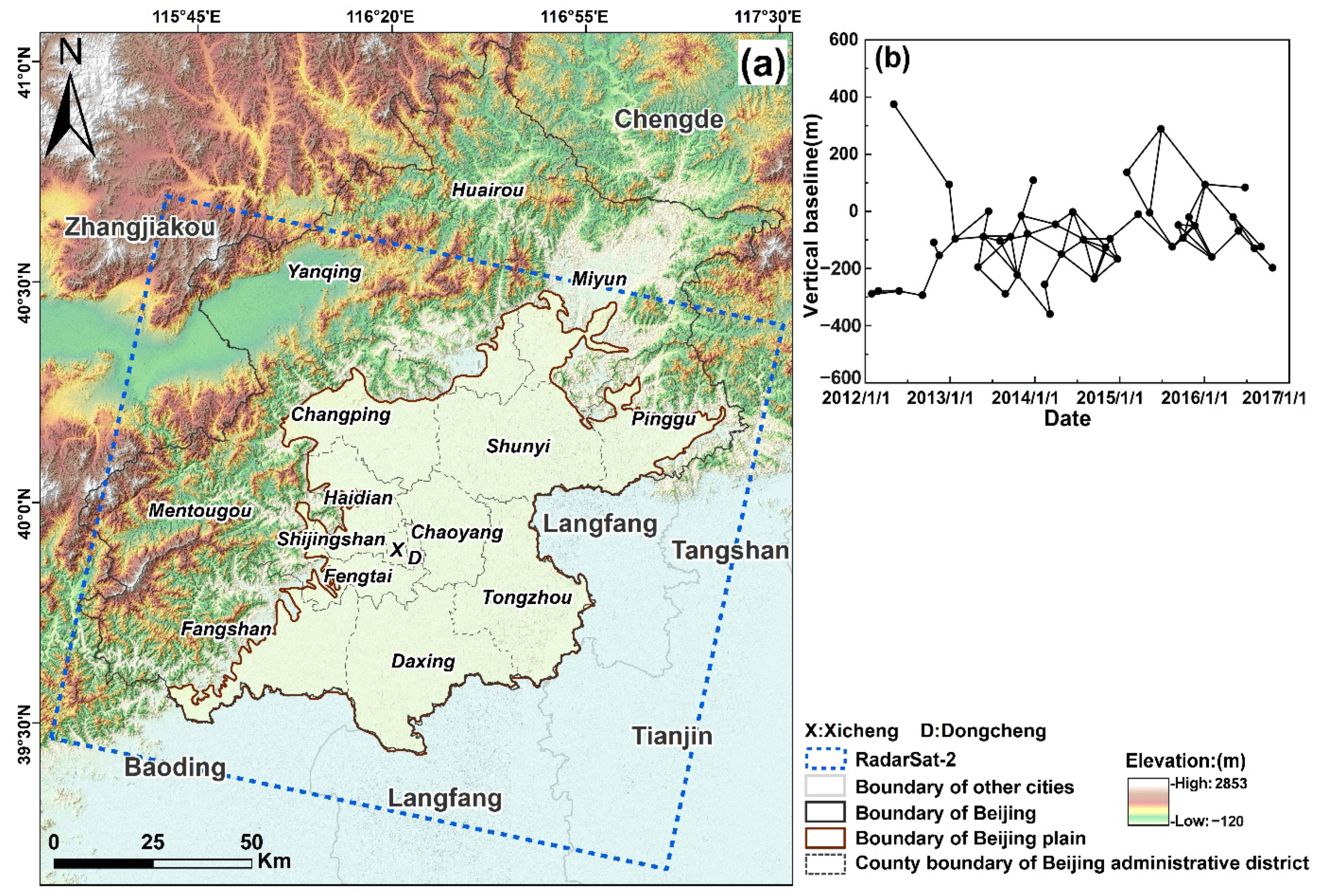
RadarSat-2 is a medium resolution radar satellite with a large range image which is equipped with a C-band sensor (wavelength:5.63 cm), and the return period is 24 days. In this study, wide-width data with 30 m nominal resolution was selected, with the descending orbit of right-view imaging and VV polarization mode adopted. The width was 150 km × 150 km, and the time span of 46 images was from 28 January 2012 to 21 October 2016. (The data coverage and vertical baseline of interference relative sets are shown in Figure 2a,b, respectively, and the acquisition parameters of the RadarSat-2 images are shown in Table 2). The details of 46 RadarSat-2 SAR images are shown in the Appendix A, Table A1. The external digital elevation model (DEM) data adopts the shuttle radar topography mission (SRTM) data provided by the National Aeronautics and Space Administration (NASA), with a spatial resolution of 90 m. The leveling data set of surface deformation is the second order leveling of the whole plain area carried out by the Geological Department of Beijing.
The results of stratified scale monitoring from 2005 to 2012 show that the main contribution layer of surface deformation in Beijing plain gradually transforms from a shallow layer to a deep one of 100 m, which is in keeping with the change in the main groundwater exploitation layer [57]. Therefore, by combining the coverage of SAR images with the continuity of monitoring time, this study selected 11 groundwater level monitoring points, the hole depth range of which was 82–150 m (the average hole depth was 105.74 m), and the time sampling frequency was daily. Here, we calculated the monthly average groundwater level change as the primary input data of this study. In addition, by establishing a buffer zone with a 100 m radius centered on the groundwater level monitoring point, the average surface deformation of coherent points in the buffer zone was calculated as the surface deformation value of the monitoring point.

3. Methods

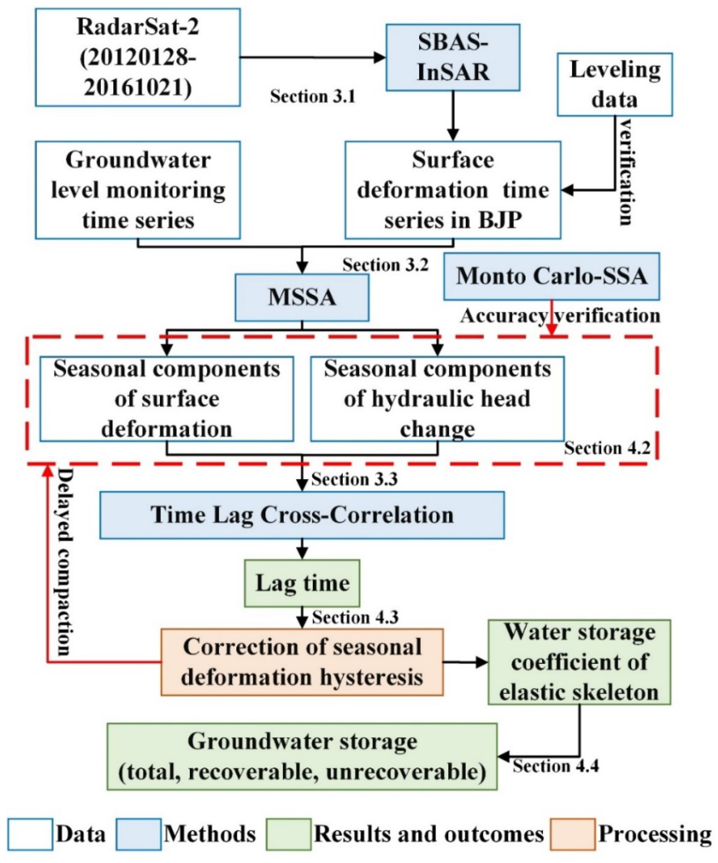
In this study, based on time series deformation information obtained by SBAS-InSAR, the seasonal components of deformation and hydraulic head change were decomposed by MSSA. Then, we introduced the TLCC approach to correct the hysteresis response of seasonal deformation relative to the variation of aquifer system head, so as to realize the estimation of aquifer storage properties and GWS loss. The overall methodology of this study is summarized as follows (Figure 3):

3.1. SBAS-InSAR Processing

The InSAR measurement technology acquires the height of the target by calculating the phase difference (interference phase) between two echo signals of the same target [58,59,60,61,62]. Berardino [41] proposed a method to improve the sampling time rate in the separation process of time and Doppler frequency by combining multiple small baseline interferences. The free combination of small baseline pairs can obtain more interference relativities with high coherence, and at the same time, more high coherence points can be selected, so as to weaken the influence of space-time de-coherence and atmospheric phase, and improve the phase unwrapping accuracy [63]. In this paper, we first identify isolated monodic slow filter phase (SFP) pixels in a short time interval by applying the SBAS method, wherein, SFP pixels represent pixels that are almost irrelevant after filtering in a short time interval and are defined by their phase characteristics. Secondly, the stable monodic SFP pixels are estimated by the correlation with the vertical baseline and its phase stability index is determined by the amplitude difference dispersion (the process for selecting stable SFP pixels is shown in the Appendix A.1, Figure A1). Then, by setting the vertical baseline (threshold < 300 m) and Doppler baseline threshold (threshold < 100 hz) to construct the relative interference, multiple small baseline sets were generated, and the deformation phase was calculated according to the phase information contained in each scene of the interference pair according to the following equation:
Φ = φ def + φ topo + φ orb + φ a t m + φ n o i s e
where φ topo is the remnant topographic phase caused by DEM error, φ orb the phase caused by trajectory inaccuracy, φ a t m the atmospheric delay phase, and φ n o i s e the noise caused by thermal noise and fiducial registration error, etc. With other phase differences subtracted, surface deformation information φ def can be obtained. Moreover, in order to improve the coherence of the differential interferogram, local slope adaptive filtering was used for interference phase filtering and the minimum-cost flow (MCF) method was used for phase unwrapping. Finally, the temporal deformation information of all SFP points could be selected.

3.2. MSSA and MC-SSA

The decomposition of the elastic component in surface deformation is of extreme importance for the inversion of hydrogeological parameters and the management of groundwater resources. MSSA, which is mathematically equivalent to an extended empirical orthogonal function algorithm (EEOFS), has been used as a data analysis method for many years in the field of digital signal processing [64]. The remarkable advantage of MSSA is that it can draw information from brief and noisy time series, and obtain nonlinear trends and periodic oscillations with different amplitudes and frequencies [65,66]. The algorithm is to establish a multichannel trajectory matrix [67] with dimension of N × L M mainly by embedding the L-dimensional time series into the trajectory matrix { X l t : l = 1, …, L ; t = 1, …, N }, and by setting the sliding lag window M . By diagonalizing the lag covariance matrix, and by calculating the k principal components of the eigenvectors and the associated single channel time series, the reconstructed components (RCs), as for a given set of exponents k , are obtained by means of the convolution algorithm. Then, according to the RCs, each signal component obtained in the time series of deformation and hydraulic head change can be segregated to gain the seasonal component, nonlinear long-term component and other noise signals with periodic changes [68].
The variables of MSSA must be uniformly sampled in time. Because of the existence of a small number of vacant values in the deformation time series during the study period, the variables used by MSSA, by using the linear interpolation method, are made to be a uniform time series with an equal time interval of 31 days (the change of head is monthly data). Furthermore, MC-SSA was applied to verify whether the disjunct seasonal signals contained false oscillations caused by red noise. In MC-SSA, as for the lth channel of X , the maximum likelihood estimation is first used to evaluate the interrelated arguments in the light of the time series X ( t ) , then a collection of mimetic red noise data is produced, with the covariance matrix C R calculated, and then the covariance matrix of the emulated data is projected onto the basis feature vectors E X of the primordial data. Finally, the equation is obtained as follows:
Λ R = E X T C R E X
where Λ R measures the similarity between the emulated data set and the primordial data. The confidence interval was set at 95% in this study. If the eigenvalues are outside 95% of the confidence interval, it is confirmed that the seasons of MSSA separation are significantly different from the red noise.

3.3. TLCC Analysis

The TLCC analysis can be used to calculate the correlation coefficient and lag time, separated by MSSA, between the seasonal surface deformation and hydraulic head change. In signal processing, cross-correlation analysis is applied to evaluate the similitude degree of two discrete-time series, as well as a function of the displacement of one sequence relative to the other (sliding dot product or sliding inner product). This kind of analysis is widely applied in a great many fields, such as pattern recognition, single particle analysis, electron tomography, cryptanalysis and neurophysiology [69,70]. In essence, by building the convolution function of two discrete time series, the cross-correlation analysis establishes the cross-correlation matrix containing the expected value of random vectors and the existence of variance, and obtains the cross-cross-covariance function, thereby calculating the cross-correlation coefficient between the two above. Then, by virtue of the maximum of the cross-correlation coefficient (or the minimum if the signal is negatively correlated), the time point at which the signal is best aligned is indicated, and it can be used to determine the delay time between two signals. The time difference τ l a g between the time series b t of surface deformation and the time series h t of hydraulic head change can be calculated by the equation below:
τ l a g = arg max c o r r h t , b t + τ
where c o r r h t , b t + τ is the cross-correlation coefficient which is used to evaluate whether there exists a strong correlation between surface deformation and hydraulic head. In this study, the TLCC analysis method was used to estimate the lag time and correct the lag response of seasonal surface deformation relative to the variation of the aquifer system head.

3.4. Estimation of Aquifer Storage Properties and GWS Loss

3.4.1. Estimation of Aquifer Skeletal Storativity Coefficient

The storage properties of aquifers are an indispensable part of water resources management. The specific storage coefficient S of confined aquifer refers to the amount of the water discharged from the compressible aquifer per unit aquifer volume when the unit head drops [71,72,73,74,75,76,77,78,79,80,81], which can be expressed as:
S = ρ g α + n β
where ρ is the water density, g the acceleration of gravity, n the porosity, and β the compressibility of water. The volumetric aquifer compressibility α expresses the change in relative volume of an aquifer skeleton as pressure changes. Generally, the compressibility of an aquifer system is much greater than that of water. Assuming that water compressibility is omitted, S k represents the water storage capacity of the skeleton related to the compressibility of the aquifer system, which can be calculated using the relationship between the stress deformation of the aquifer and the change of hydraulic head:
S k = S s k × b 0 = Δ b / Δ h
where S s k is the specific skeleton water storage performance, b 0 the initial thickness of confined aquifer, Δ b the variation in the thickness of the confined aquifer, and Δ h the variation in the hydraulic head. The aquifer storativity coefficient can be divided into inelastic and elastic, the magnitude of which is affected by the change of historical hydraulic head level and surface deformation [46,48]. Two isolated components of the elastic ( S k e ) and inelastic ( S k v ) skeletal storativity coefficient are applied in order to explain this significant difference. The storativity coefficient of the elastic skeleton S k e can be reckoned by the specific value of the seasonal deformation components Δ b s to the seasonal hydraulic head component Δ h s . The equation is as follows:
S k e = Δ b s / Δ h s
Since the loose sand in an aquifer system usually does not undergo inelastic compaction [82], the elastic deformation occurs in an aquifer regardless of whether the hydraulic head is higher than the pre-consolidated hydraulic head [48]. However, because the seasonal deformation only comes up in the aquifer where the hydraulic head is lower than the pre-consolidation hydraulic head, Equation (6) can only be used to estimate the storage capacity of the elastic skeleton in the aquifer system.

3.4.2. Quantization of GWS Depletion

In a confined aquifer, water delivery by pumping derives from water expansion attributed to pore water pressure reduction and compaction of the aquifer system skeleton caused by an effective stress increase [48]. Therefore, in this study, InSAR deformation results were applied to calculate the cumulative deformation volume of the aquifer in the study period, which can be approximately tantamount to the variation of the TGWS in the aquifer system ( Δ V t o t a l ) [83]:
Δ V t o t a l = Δ b t o t a l × S
where Δ b t o t a l is the cumulative surface deformation variables during the study bucket, and S the acreage of the aquifer. After the hydraulic head returns to its initial status, the GWS changes induced by the compaction of elastic soil skeleton begin to recover. Therefore, recoverable GWS (RGWS) in the aquifer system can be expressed as [38]:
Δ V r = S k e × Δ h t o t a l × S
where Δ V r is the change amount of RGWS, S k e the elastic skeletal storativity coefficient reckoned by utilizing Equation (6), and Δ h t o t a l is the change amount of total hydraulic head during the study period. When the hydraulic head declines under the pre-consolidation head, the physical rearrangement of particles in the aquifer gives rise to inelastic compaction, which can bring about the depletion of UGWS. The amount of UGWS depletion ( Δ V i ) can be estimated by the amount of loss in TGWS minus the amount of change in RGWS:
Δ V i = Δ V t o t a l Δ V r
In this study, inverse distance weight (IDW) interpolation in ArcGIS is used to conduct spatial interpolation for discrete data in order to explore the spatial distribution of the elastic skeletal storativity coefficient and GWS variation.

4. Results

4.1. Evolution Analysis of Deformation Characteristics

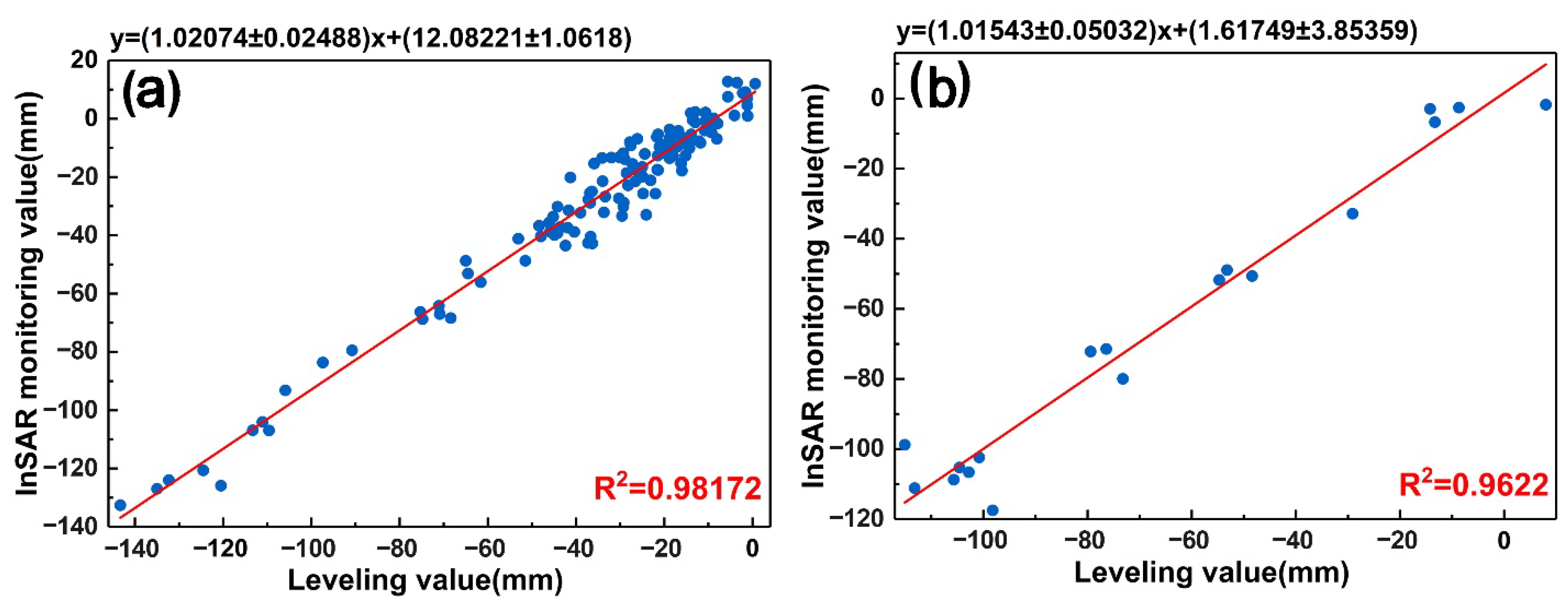
In order to ensure the accuracy of InSAR surface deformation data, leveling data of 80 leveling points (2012–2013) and 14 leveling points (2015–2016) were selected from the second order leveling data network of surface deformation in Beijing plain for verification. By establishing a buffer zone with a radius of 100 m centered on every leveling point, the stable coherent points were screened. Then the deformation value of radar line-of-sight (LOS) direction obtained by SBAS-InSAR processing was converted into a vertical deformation value by dividing by the included angle of LOS direction. Finally, we performed linear regression fitting on the leveling data and SBAS-InSAR vertical deformation results and calculated the goodness of fit R square (R2). The closer the R2 value is to 1, the better the fitting degree of the regression line to the observed value (see Appendix A.2. for detailed verification process). The linear regression results of RadarSat-2 and leveling, the results show, were 0.98 and 0.96, respectively (Figure 4a,b), which indicates that the deformation information deduced by RadarSat-2 was of reliable accuracy.
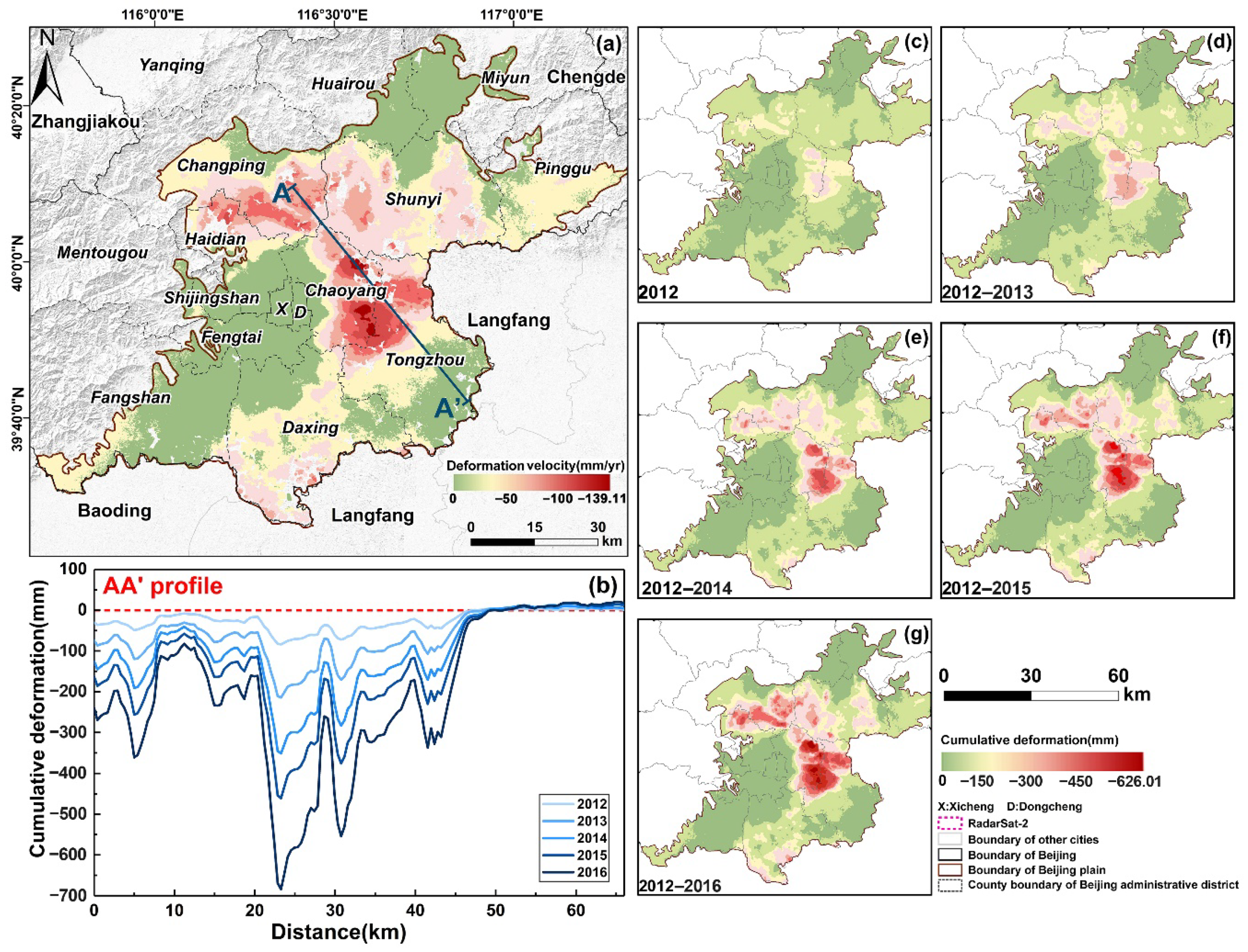
As is shown in the average annual deformation velocity obtained from RadarSat-2 data by virtue of SBAS-InSAR (Figure 5a), the regional surface deformation developed rapidly during the period from January 2012 to October 2016, and the average annual deformation velocity ranged from 0 mm/yr to 139.11 mm/yr, with great differences in spatial distribution. Two major subsidence funnels were formed in the north and the south of Beijing, with a number of deformation centers connected into a whole piece. The largest land subsidence funnel was located in the areas of Chaoyang Jinzhan–Tongzhou (CJT), and the second largest one in the areas of Changping Baxianzhuang–Haidian Shangzhuang (CBHS), where the maximum cumulative deformation reached −626.01 mm, and the area with annual average deformation over 60 mm was 249.77 km2. The specific data of cumulative deformation difference in each year are shown in the Appendix A, Table A2. The hydrogeological profile line AA’ crosses the two main subsidence funnels, from CBHS to CJT. The cumulative deformation of profile line AA’ from 2012 to 2016 is shown in Figure 5b, and we found that the increment of cumulative deformation decreased significantly after 2013. The evolution trend of cumulative surface deformation in time series (Figure 5c–g) also shows that, affected by the SNWDP, the annual surface deformation velocity began to slow down significantly after 2014 and reached a minimum of 0–127.42 mm/yr in 2015. The area with annual deformation over 60 mm also reached a minimum of 246.92 km2 (53.41 km2 less than that in 2014).

4.2. Separation of Seasonal Surface Deformation and Hydraulic Head Variation Components

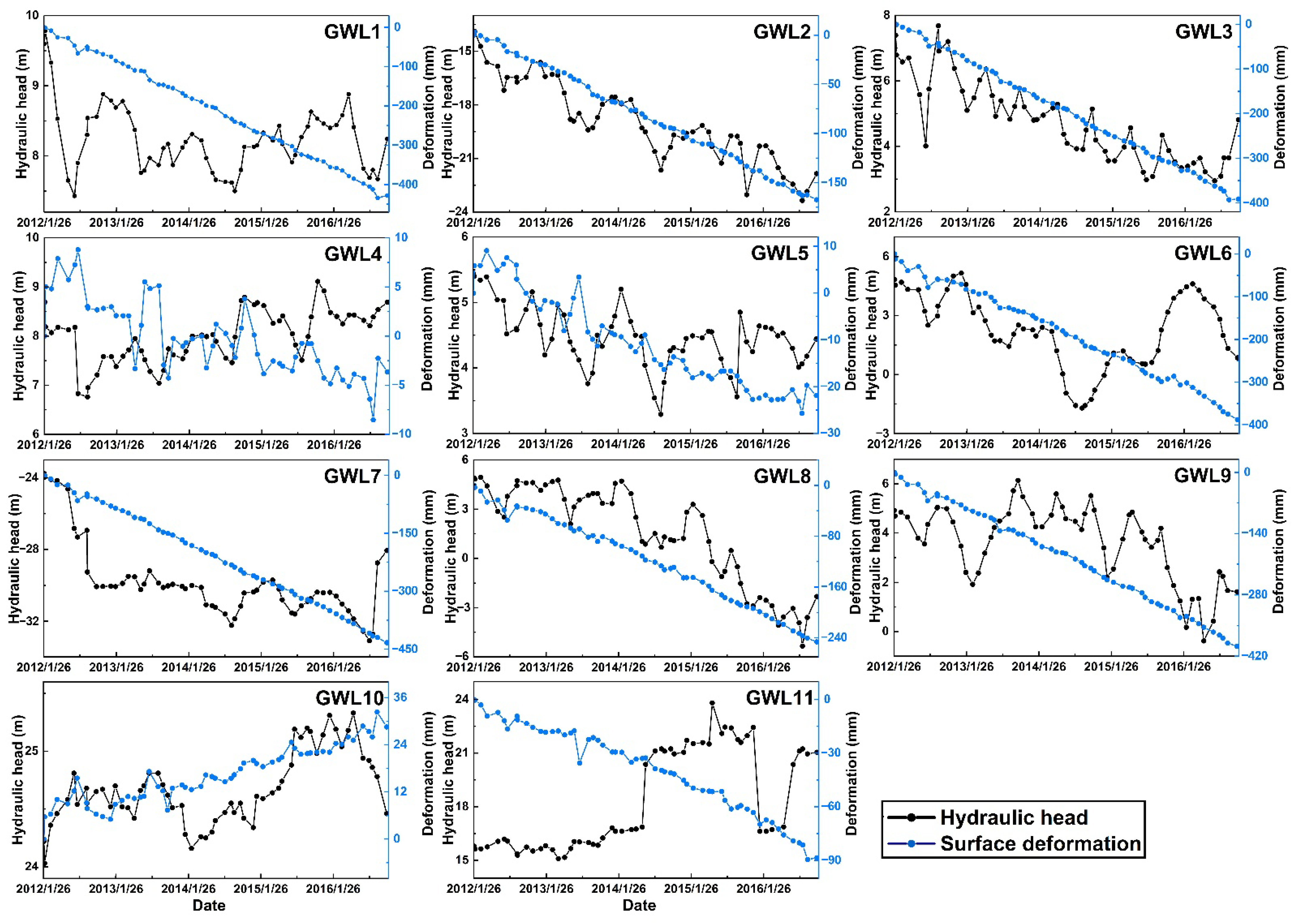
By comparing the trend of cumulative surface deformation with the groundwater level change of groundwater level monitoring points (Figure 6), it was found that the deformation of most monitoring points was positively correlated with the water level. On the whole, the surface deformation declined to varying degrees, and the downward trend between the deformation and head change at GWL2, 3, 5, 6, 7, 8 and 9 was relatively consistent. Compared with deformation, the hydraulic head of confined aquifer fluctuated more significantly in time series due to the influence of periodic groundwater exploitation and precipitation. Among these points, the head change at GWL2, 3, 5, 6, 7, 8 and 9 showed a downward trend, while GWL1, 4, 10 and 11 showed a stable and even rising trend. It is worth noting that, after the SNWDP formally diverted water to Beijing at the end of 2014, the pumping rates of the groundwater well field decreased, resulting in an increase in the overflow recharge of middle-deep confined aquifers. Therefore, the head of the middle-deep confined aquifers recovered significantly at some groundwater level monitoring points, such as GWL1, 4, 5, 6, 7, 9, 10 and 11. Among them, the maximum head rebound was located at point 6, with a rebound of 5.41 m from December 2014 to March 2016. However, the head change of the middle-deep confined aquifer at GWL2, 3 and 8 still maintained a long-term downward trend, and even decreased again after water head recovery at GWL1, 6, 9 and 10, indicating that the deep groundwater in these areas may still have been over extracted.
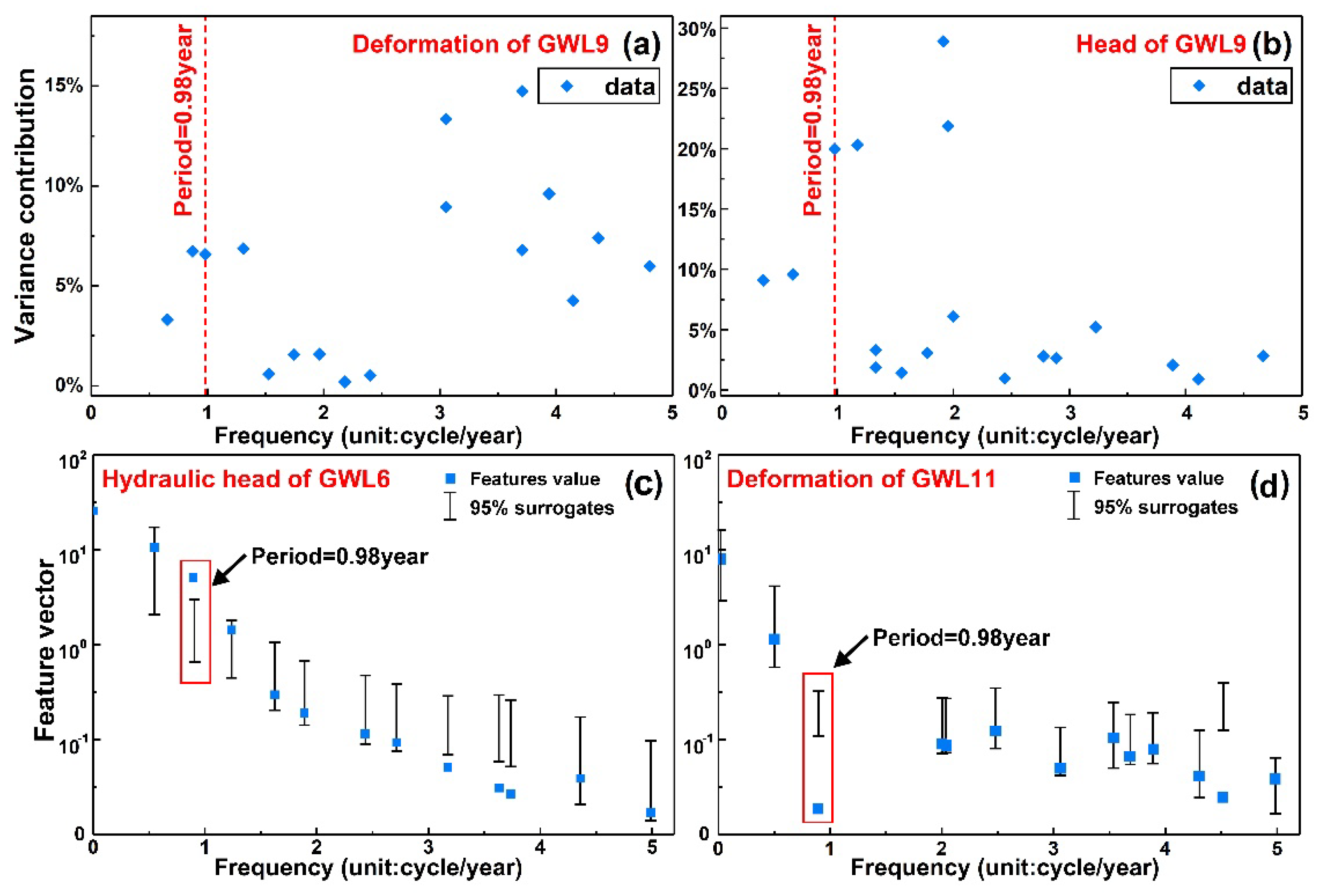
In order to further explore the variation relationship and characteristics of seasonal deformation and seasonal hydraulic head, we applied the MSSA approach to decompose the seasonal signals of these two kinds of temporal information, respectively (the delay window was 15), and retained 20 RCs of each group, including low-frequency long-term trend and noise signals. Here, we take the seasonal head of GWL5 and the seasonal deformation of GWL6 (Figure 7a,b), where the red dots and line represent periodic oscillations at this point. By combining characteristics, such as amplitude and wave period length, it can be clearly distinguished from other RCs with different frequencies. According to the variance contribution rate corresponding to the main frequency associated with different RCs (Figure 8a,b), it was found that the variance contribution rate of the seasonal deformation component was about 6.58% while that of the seasonal head component was about 19.97%. In addition, in order to ensure that the separated seasonal signals did not contain stray oscillations caused by atmospheric delay phase, we utilized the MC-SSA to verify the authenticity, through to the different frequency characteristic vector by building a 95% confidence interval (Figure 8c,d), and found that the frequency (f = 0.98) corresponding to the seasonal signals was outside the error bar. This indicates that the seasonal components extracted by MSSA were authentic and dependable.
Therefore, by further comparing the seasonal components of surface deformation and hydraulic head change, obtained by means of MSSA (Figure 9), it was found that the seasonal surface deformation and hydraulic head change of almost all monitoring points had good consistency and fluctuation, with obvious periodic oscillation occurring. By further comparing the amplitude and the position time at the peak/trough of the seasonal deformation and the head change, it was found that there was a lag response of different degrees between the two above, with characteristic spatial differences. Among them, the lag response time of GWL1, 3, 4, 5 and 9 was obviously longer than that of other groundwater level monitoring points, while the peak interval at GWL6, 7, 8, 10 and 11 was significantly smaller than that of other points, which may well be related to the lithology of the aquifer, including the thickness of particulate matter and the thickness of the compressible clay layer. Therefore, it was necessary to obtain the seasonal deformation corresponding to a prescribed head change in time considering the hysteresis influence so that the aquifer storage properties could be further estimated.

4.3. Hysteresis Correction and Estimation of Elastic Skeletal Storativity Coefficient

Surface deformation has the lag different degrees to the change of head (Figure 9). The cross-correlation coefficient and lag time (Figure 10) between the seasonal surface deformation and the change of head through the TLCC were compared and analyzed in the study, and meanwhile, the seasonal deformation through constant displacement was calibrated using the estimated time lag. Moreover, TLCC analysis was used to determine whether there was a strong correlation between surface deformation and the groundwater level change. If the maximum cross-correlation coefficient is greater than 0.5, the seasonal fluctuation near the monitoring well is most likely to be caused by seasonal head change, whereas if the maximum cross-correlation coefficient is less than 0.5, the seasonal deformation or head change may well be disturbed by noise so that the correlation between them is weaker. By comparing the results of the TLCC analysis (Figure 10), it was found that there were spatial differences in the lag response time of different groundwater level monitoring points. The longest lag response time of GWL4 was 244 d, while the shortest lag response time of GWL6 and GWL10 was 0 d. Furthermore, the maximum correlation of all groundwater level monitoring points was greater than 0.5, and the maximum value was 0.96 at GWL7, indicating that there was a strong correlation between seasonal deformation and seasonal hydraulic head change, and the surface deformation there was mainly induced by hydraulic head fluctuation corresponding to the mining depth. The maximum correlation coefficients of GWL1 and 3 were between 0.50 and 0.55, which are smaller than other points, which may be because of noisy interference, unapparent and anomalous seasonal deformation signals, and the deformation presumably caused by deeper hydraulic head fluctuations.
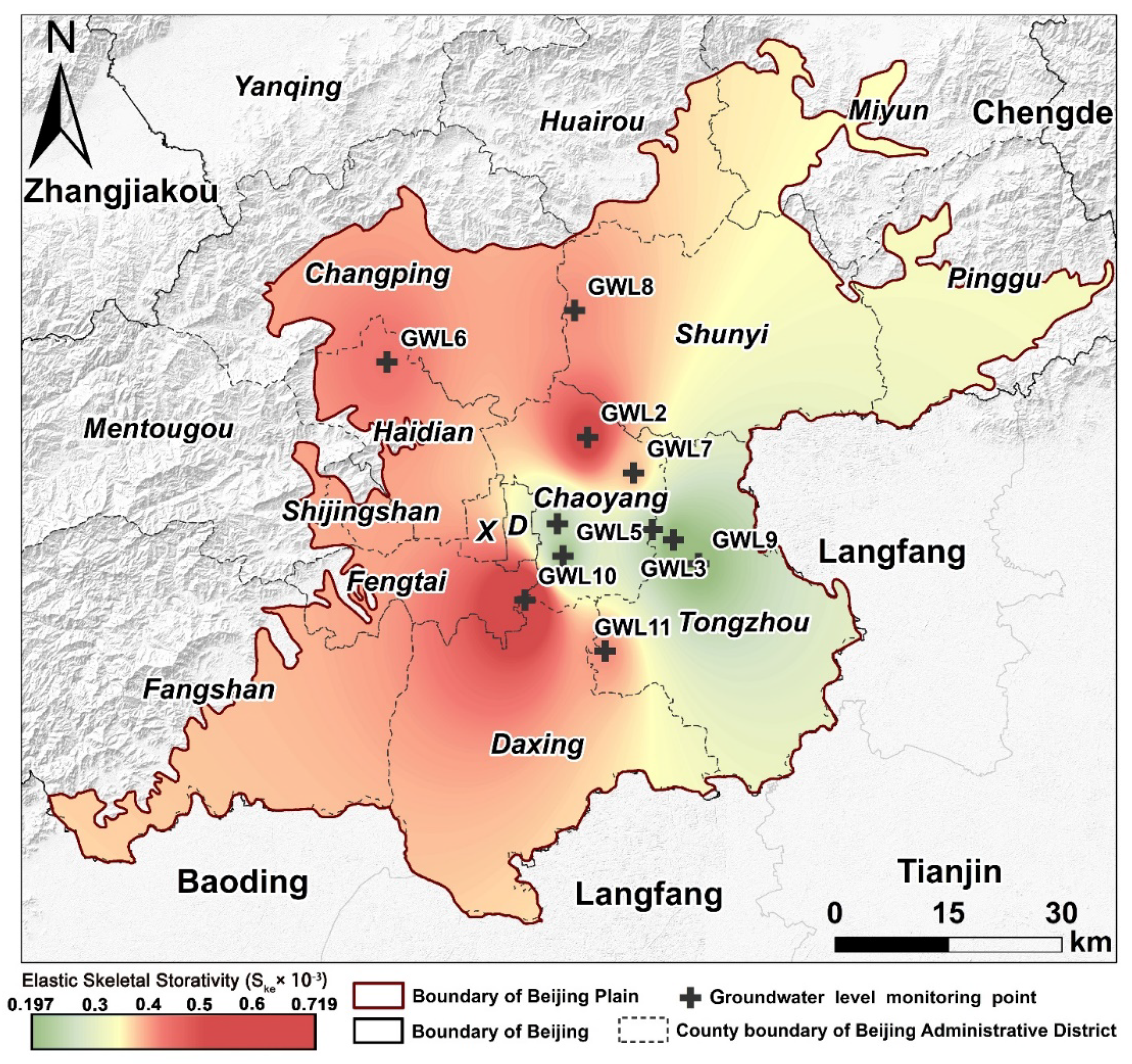
For the purpose of representing the spatial variability of the storativity characteristics of the aquifer system, the elastic skeletal storativity coefficient of 11 monitoring wells were estimated by means of Equation (6) (as shown in Table 3). The calculated results were in the range of the theoretical value domain of the S k e coefficient n × 10−5–n × 10−3 [1,34]. For the sake of exploring the inhomogeneity on the spatial scale of S k e , IDW interpolation was applied to obtain the spatial distribution of S k e (Figure 11). The values of S k e ranged from 0.197 × 10⁻³ to 0.719 × 10⁻³, manifesting obvious spatial differences and the aquifer lithology at all points above was composed of 2–3 layers of sand and gravel layers. In general, considering the influence of the geological structure of the Beijing plain, the impact of aquifer permeability in the pluvial fan interaction area became weaker step-by-step, which, to a certain extent, brought about the elastic skeletal storativity coefficients on the space diversity, as well as the uneven subsidence of Beijing.
Among them, the S k e values at GWL2, 6, 8,10 and 11 points were greater than 0.40 × 10⁻³, and the other four points, except GWL6, were located in the less developed area of subsidence, especially GWL10, which did not even show obvious subsidence during the study period. Meanwhile, combined with the structural characteristics of the Beijing plain pore aquifer (Figure 1) and regional subsidence evolution (Figure 5), we found that the reason why S k e at GWL10 was larger than others may be that the thickness of the compressible clay layer at GWL10 was relatively thin (between 50–100 m), the water-rich condition better (between 3000–5000 m3/d) and the pumping rate of groundwater wells small, with the aquifer overflow replenishment fast and hydrodynamic delay small. However, the compressible layer at points GWL2, 6 and 8, which are at the edge of the subsidence funnel, was thicker (between 150–200 m), and there was poorer water-rich condition (between 500–3000 m3/d), so the S k e value was larger than others. In contrast, the S k e values at the other points were less than 0.40 × 10⁻³. GWL1, 3, 4, 5, 7 and 9 points were close to the center of the CJT subsidence funnel. This may be due to the thickness of the compressible clay layer (mostly between 150–200 m), the relatively uniform distribution of lithology and water-rich conditions (all between 1500–3000 m3/d) of the aquifer system, and the long hydrodynamic delay time of the aquifer. In addition, the groundwater pumping rate at these points was large, and the short-term recovery caused by human action cannot change the fact that the middle-deep confined head at these points shows a long-term decline. In the long term, the process of middle-deep confined head declining and land subsidence caused by over-exploitation of groundwater is irreversible.

4.4. Quantization of GWS Depletion

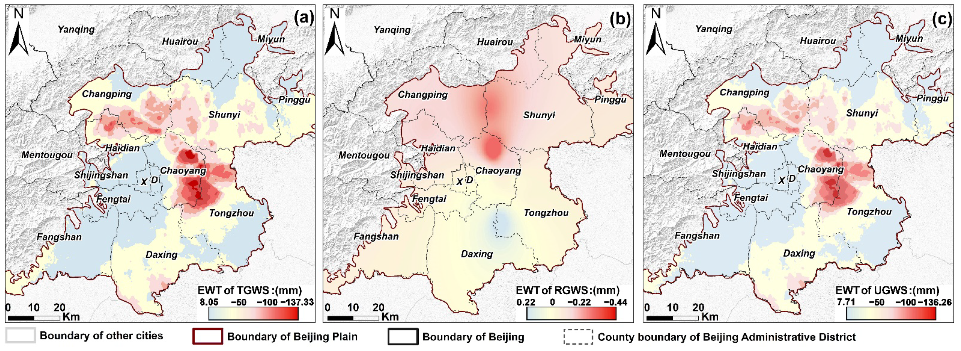
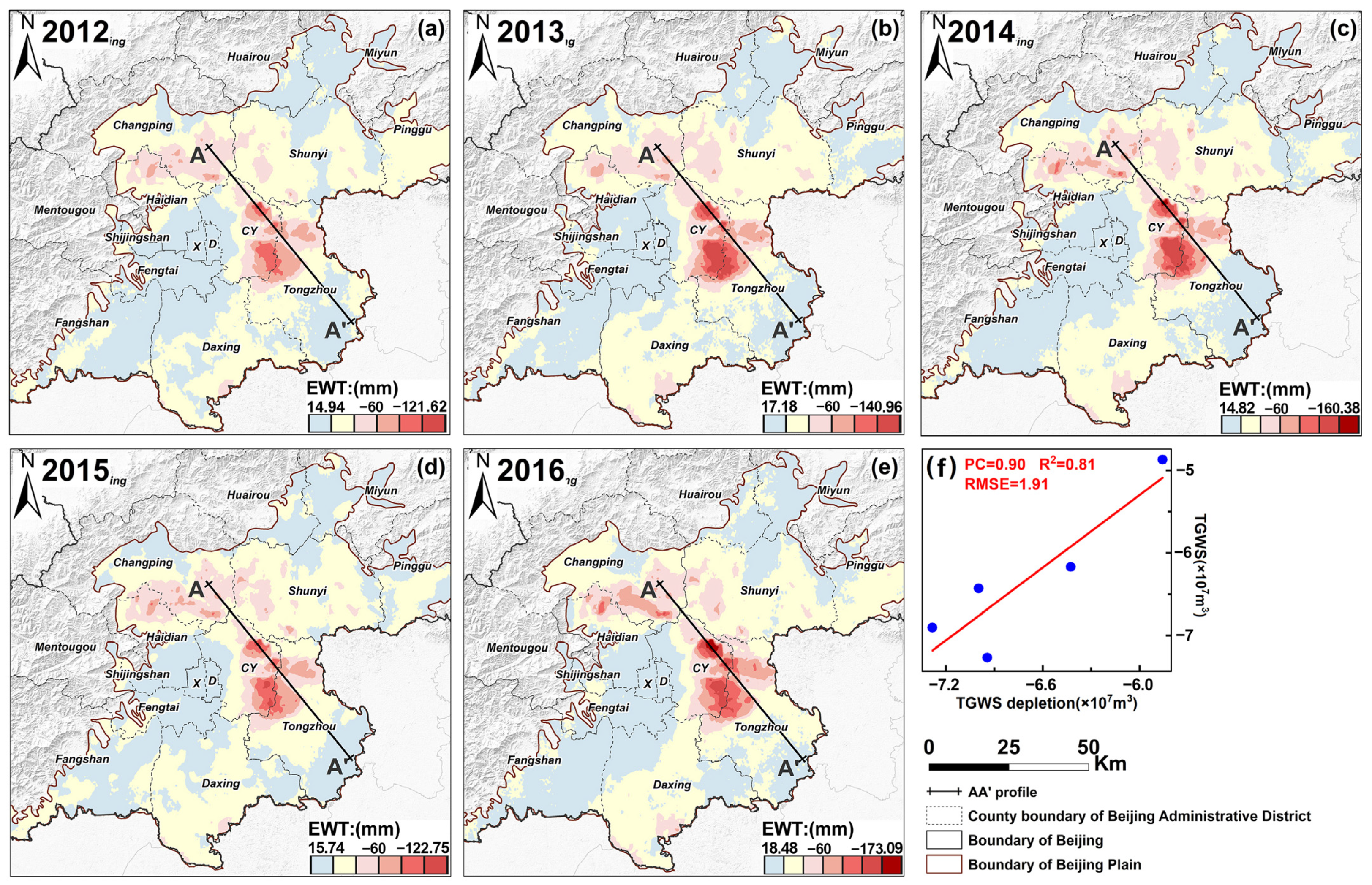
In confined aquifer systems, the variation of TGWS can be approximately equal to the cumulative surface deformation variable. Therefore, by means of Equation (7) in Section 3.4, the loss of TGWS during the study period can be calculated, and the volume of RGWS and the volume of UGWS depletion can be calculated by means of Equations (8) and (9). To characterize the spatial differences of GWS changes, all changes are expressed as equivalent water thickness (EWT), so as to obtain the average distribution of TGWS from January 2012 to October 2016 (Figure 12a), the average volume of RGWS (Figure 12b) and the average volume of UGWS depletion (Figure 12c). During the study period, the loss volume of the TGWS was about −3.276 × 10⁸ m3, and the average annual loss was −6.702×10⁷ m3; the change volume of RGWS was −2.948 × 10⁷ m3, and the average annual change was −0.602 × 10⁷ m3. The depletion volume of UGWS was −3.084 × 10⁸ m3, and the average annual depletion was −6.168 × 10⁷ m3. The depletion of UGWS accounted for 92.03% of the TGWS volume, while RGWS accounted for 7.97%. We compared the annual change GWS in the Beijing Water Resources Bulletin as verification (Figure 13f), which shows that Pearson’s correlation (PC) coefficient was 0.90, indicating that this result was relatively reliable.

5. Discussion

5.1. Temporal Relationship between Deformation and UGWS Loss

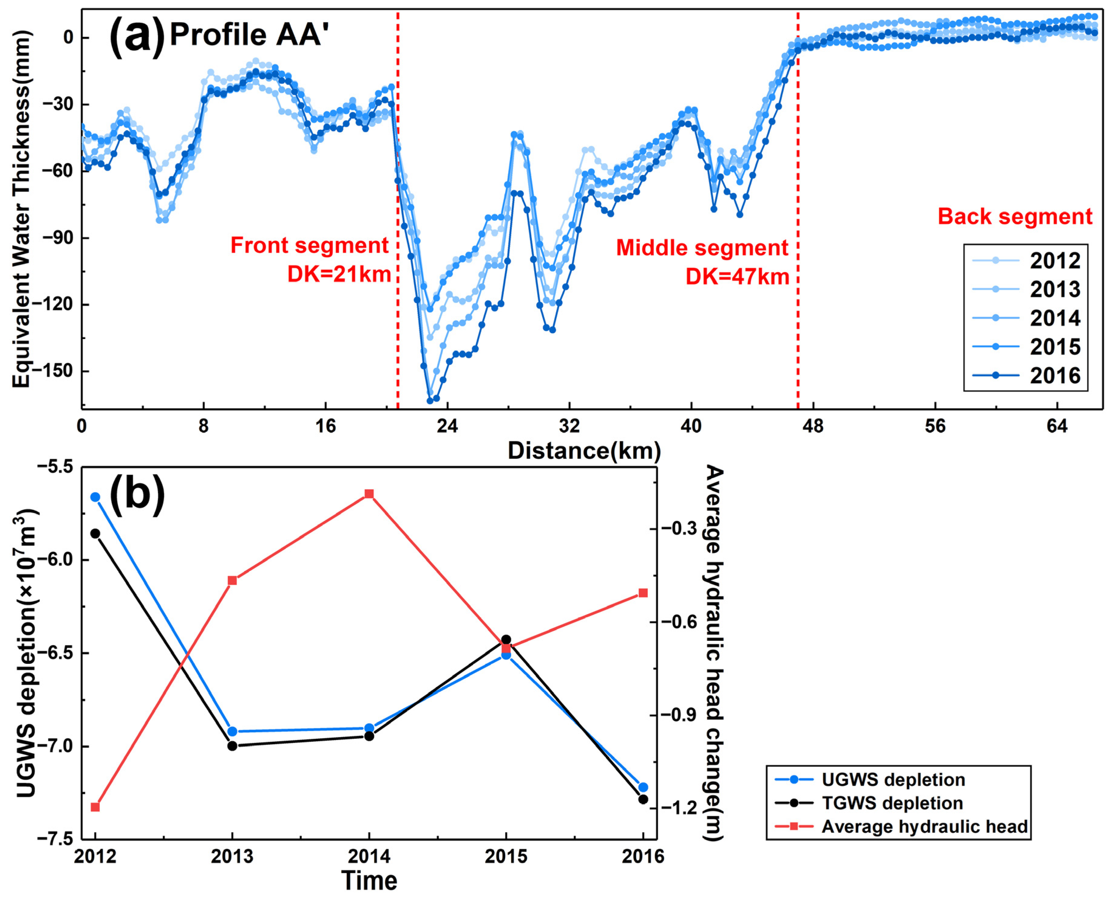
To explore the temporal-spatial distribution features of UGWS depletion, the depletion volumes of UGWS from January 2012 to January 2013, from January 2013 to January 2014, from January 2014 to January 2015 and from January 2015 to October 2016, were calculated over the timescale (Figure 13a–e). In light of the comparative analysis of the volume of UGWS depletion year-by-year and the change of average total hydraulic head (Figure 14b), it was found that the overall change of UGWS depletion was not great from 2012 to 2016, and the UGWS depletion lagged behind the change of total hydraulic head with a lag time of about one year. The depletion of UGWS in 2013 (Figure 13b), in terms of the timescale, showed a decreasing trend, but the unrecoverable area showed a trend of expansion compared with that in 2012 (Figure 13a). After 2013, the depletion of UGWS still increased but the depletion rate was significantly slower than before. Even after 2014, the depletion of TGWS and UGWS decreased significantly to varying degrees, which may be the short-term result of the policy of limiting and reducing groundwater overexploitation under the auspices of the SNWDP. However, from 2015 to 2016, the depletion of TGWS and UGWS continued to increase, mainly characterized by an expanding trend in the unrecoverable area of the CBHS subsidence funnel in the north and a deepening trend in the unrecoverable degree of the CJT subsidence funnel in the south.
In addition, by comparing the response relationship between the depletion of UGWS and the change of total hydraulic head in time series (Figure 14b), we also found that the depletion of the corresponding UGWS only decreased in 2014 after the total hydraulic head recovered in 2013. Then the total head recovered to the maximum at the end of 2014, while the depletion of UGWS reached the minimum in 2015. After 2015, the total head decreased again, while the corresponding loss of UGWS increased one year later in 2016. Therefore, we found that under the guidance policy of the SNWDP to reduce over-exploitation of groundwater, the total head in 2016 recovered to a certain extent compared with that in 2015, and it can be predicted that the depletion of UGWS will also decrease afterwards. This also shows that the SNWDP played an important role in alleviating the over-exploitation of groundwater, protecting groundwater resources and controlling regional land subsidence.

5.2. Spatial Relationship between Deformation and UGWS Loss

According to the evolution process of UGWS depletion on the spatial scale (Figure 13a–e), the depletion of UGWS in CBHS was obviously reduced, while the depletion of UGWS in CJT region was still severe because the compressible clay soil layer was thick, the main aquifer particles were fine sand, and the subsidence development was long-term. As the area from CJT is the sub-center of Beijing and densely populated, affected by human activities and dynamic and static loads, the compressible viscous soil layer in the aquifer system in this area has been stressed for a long time, occurs over a wide range, and the deformation is serious. Thus, the depletion of UGWS remains serious. By drawing one profile line AA’ (Figure 13a–e) across the two main subsidence funnels in the north and south, it was found that the depletion of UGWS during 2015–2016 decreased significantly and presented a segmented distribution feature. Therefore, we divided the profile line AA’ into three segments (front, middle and back) according to the degree of rebound (Figure 14a).
The front segment of the profile line (DK < 21 km) was mainly located in the CBHS subsidence funnel in the north Beijing plain. Although the depletion of UGWS in this part increased continuously from 2012 to 2014, the increment decreased year by year, and the depletion of UGWS decreased significantly after 2015, and even continued to decrease after 2016. However, the middle segment of the profile line (21 km < DK < 47 km) mainly passed through the CJT subsidence funnel in the south Beijing plain. Combined with the hydrogeological structure of the profile line (Figure 1c), it was found that the thickness of the compressible clay layer in this part was greater, and the depletion of UGWS decreased significantly in 2015, but then continued to increase in 2016. However, the back segment of the profile line (DK > 47 km) was located in the southeast of the Beijing plain where no significant subsidence has been found. Therefore, the depletion of UGWS in this part fluctuated slightly on the basis of the overall decrease, but the overall change was not obvious.
In summary, it was found that the depletion of UGWS not only fluctuated temporally due to the impact of the SNWDP and groundwater abstraction reduction policy, but also showed differences spatially among different regions. On the whole, the depletion of UGWS decreased after 2015, but the unrecoverable degree of the CJT subsidence funnel in the south still increased compared with the CBHS. Moreover, the CJT is located in the sub-center of Beijing, with a large population density and serried buildings. A large amount of groundwater has been exploited, which further indicates that the soil in this region will continue to be compacted and it is difficult to recover GWS. In consequence, it is urgent to restrict the exploitation of groundwater and control the growth of subsidence.

5.3. Uncertainty Analysis and Future Work

In the process of using SBAS-InSAR monitoring technology to obtain the long-term surface deformation and of utilizing MSSA to obtain the seasonal component of surface deformation and hydraulic head change, there were some uncertainty errors which mainly include the following points:
  • As is shown in the study, if the aquifer system has significant horizontal deformation, without considering the horizontal deformation and its contribution to skeleton storage, the estimated elastic skeletal storativity coefficient may well show a deviation which is less than the theoretical value.
  • The uncertainty error is connected with the precision of deformation velocity obtained by the SBAS-InSAR technique. This is mainly caused by the atmospheric latency phase, decoloration and registration errors, according to previous research.
  • There may be errors caused by human factors with respect to the monitored groundwater level and the real groundwater level.
  • As the time series of surface deformation needs to be matched against the head change, the linear interpolation method of supplementing the vacancy value will also produce some errors.
  • For coherent points, which are characteristic of significant surface deformation, the long-term trend and the random noise using MSSA may not be able to be completely eliminated from the time series of surface deformation and head change. Although a 95% confidence interval was constructed for verification by means of MC-SSA, there may still be uncertain noise in the seasonal component obtained by separation. Although we have adjusted the lag of the seasonal surface deformation, it is a fact that more frequent InSAR and hydraulic head data sampling (daily or weekly) time series over longer periods are required to obtain more accurate lag times. Other errors may be caused by the fact that the lag time of surface deformation and head change cannot be completely accurately corrected.

6. Conclusions

In order to realize inversion of GWS variation from the perspective of remote sensing, this study, based on the surface deformation field obtained by SBAS-InSAR, combined with head change data, utilized MSSA to separate the seasonal components of the surface deformation and hydraulic head variation. Then the lag response of surface deformation relative to head change was corrected by introducing the TLCC method, so as to estimate the aquifer storage properties and GWS loss under given hydraulic head observations. Finally, we particularly discussed the temporal-spatial response relationship of GWS loss and surface deformation in the context of SNWDP. The main conclusions of this study are as follows:
(1) The average surface deformation velocity of the Beijing plain was up to 139.11 mm/yr, and the maximum cumulative deformation was −626.01 mm from January 2012 to October 2016, forming two main subsidence centers of CJT in the southern plain and CBHS in the northern plain.
(2) After the SNWDP was officially implemented in Beijing at the end of 2014, the head of middle-deep confined aquifers at some points showed a short-term recovery, with a maximum rebound of 5.41 m in two years, and then continued to decline. On this basis, the real seasonal signals of surface deformation and water head were obtained by MSSA, and their fluctuations had spatial differences.
(3) The S k e and the lag time of surface deformation in response to hydraulic head change were spatially different in different places. By introducing TLCC analysis, it was found that the maximum lag time of the two responses was 244 d and the maximum correlation coefficient was 0.96. Meanwhile, the points near the center of CJT subsidence funnel, with a thick compressible clay layer and poor water-richness, had relatively smaller S k e values and the hydrodynamic delay time of aquifer was longer.
(4) This study further quantifies the loss volume and spatial-temporal change of TGWS, RGWS and UGWS from 2012 to 2016. The average annual change of TGWS was −6.702 × 10⁷ m3, and the average annual depletion volume of UGWS was −6.168 × 10⁷ m3, accounting for 92.03% of the TGWS. The depletion of UGWS lagged behind the change of total head with a lag time of about one year. In addition, the depletion of UGWS showed regional differences temporo-spatially. After 2015, the northern CBHS subsidence funnel showed a trend of decreasing UGWS depletion but gradually expansion of the unrecoverable area. However, the UGWS depletion of the southern CJT subsidence funnel only rebounded in the short term after 2015 and then continued to increase.
In general, in the context of the SNWDP, the over-exploitation of groundwater in Beijing plain has been limited and alleviated to some extent. However, the process of over-exploitation of groundwater, leading to the decline of middle-deep confined head and long-term depletion of GWS, is still irreversible. In other words, it is a long and arduous task to prevent and control land subsidence and restore groundwater resources. Nevertheless, it is necessary to wait longer to evaluate the role of the SNWDP in replacing part of the water demand in the capital and slowing down the over exploitation of groundwater.

Author Contributions

X.Z. designed the experiments, implemented the algorithm, analyzed the results, and wrote the paper. B.C. made important suggestions on writing the paper. H.G., K.L. and C.Z. provided crucial guidance. Z.L. and D.Z. helped organize the data. All authors have read and agreed to the published version of the manuscript.

Funding

This work was supported by Beijing Outstanding Young Scientist Program (No. BJJWZYJH01201910028032), Beijing Youth Top Talent Project, National Natural Science Foundation of China (No. 41930109/D010702, 41771455/D010702), Beijing Natural Science Foundation (No. 8212042), National “Double-Class” Construction of University Projects, Beijing Postdoctoral Research Foundation (No. 2018M641407).

Acknowledgments

Thanks to the Hydrological and Water Resources Monitoring and Evaluation Center of the Ministry of Water Resources of China and relevant departments of China Geological Environment Monitoring Institute for providing data support and verification.

Conflicts of Interest

The authors declare no conflict of interest.

Appendix A

Table A1. Image information table of 46 Radarsat-2 SAR images.
NumberSAR SensorImage Acquisition DateTrackOrbitOrbit Direction
1Radarsat-22012012862-26D21528Descending
2Radarsat-22012022163-26D21871Descending
3Radarsat-22012040965-26D22557Descending
4Radarsat-22012052767-26D23243Descending
5Radarsat-22012083171-26D24615Descending
6Radarsat-22012101873-26D25301Descending
7Radarsat-22012111174-26D25644Descending
8Radarsat-22012122976-26D26330Descending
9Radarsat-22013012277-26D26673Descending
10Radarsat-22013042881-26D28045Descending
11Radarsat-22013052282-26D28388Descending
12Radarsat-22013061583-26D28731Descending
13Radarsat-22013080285-26D29417Descending
14Radarsat-22013082686-26D29760Descending
15Radarsat-22013091987-26D30103Descending
16Radarsat-22013101388-26D30446Descending
17Radarsat-22013110689-26D30789Descending
18Radarsat-22013113090-26D31132Descending
19Radarsat-22013122491-26D31475Descending
20Radarsat-22014021093-26D32161Descending
21Radarsat-22014030694-26D32504Descending
22Radarsat-22014033095-26D32847Descending
23Radarsat-22014042396-26D33190Descending
24Radarsat-22014061098-26D33876Descending
25Radarsat-220140728100-26D34562Descending
26Radarsat-220140914102-26D35248Descending
27Radarsat-220141101104-26D35934Descending
28Radarsat-220141125105-26D36277Descending
29Radarsat-220141219106-26D36620Descending
30Radarsat-220150205108-26D37306Descending
31Radarsat-220150325110-26D37992Descending
32Radarsat-220150512112-26D38678Descending
33Radarsat-220150629114-26D39364Descending
34Radarsat-220150816116-26D40050Descending
35Radarsat-220150909117-26D40393Descending
36Radarsat-220151003118-26D40736Descending
37Radarsat-220151027119-26D41079Descending
38Radarsat-220151120120-26D41422Descending
39Radarsat-220160107122-26D42108Descending
40Radarsat-220160131123-26D42451Descending
41Radarsat-220160506127-26D43823Descending
42Radarsat-220160530128-26D44166Descending
43Radarsat-220160623129-26D44509Descending
44Radarsat-220160810131-26D45195Descending
45Radarsat-220160903132-26D45538Descending
46Radarsat-220161021134-26D46224Descending

Appendix A.1. This Part Includes the Processing Flow of SBAS-InSAR Technology and the Selection Method of Stable Slow Filter Phase (SFP) Pixels

Figure A1. The processing flow of SBAS-InSAR technology.
Remotesensing 14 00991 g0a1
  • The selection method of stable slow filter phase (SFP) pixels:
Different from the selection of stable permanent scatterer (PS) pixels in PS-InSAR, when selecting SFP pixels, firstly, the surrounding pixels are band-pass filtered and the spatial correlation contribution of pixel interference phase is estimated. Then, the spatially uncorrelated viewing angle error term is estimated by its correlation with the vertical baseline. The error term includes the contribution of the spatially uncorrelated height error and the deviation between the phase center of the pixel and its physical center. The subtraction of these two estimates will leave the estimated value of the decorrelation noise of the pixel, and then use it according to the actual situation γ X to select the final SFP pixel.
γ X = 1 N i = 1 N exp 1 ψ x , i ψ ˜ x , i Δ ϕ ˜ θ , x , i u
where ψ x , i is the wrapped phase of pixel x in ith interferogram, ψ ˜ x , i is the estimation of spatial correlation term, Δ ϕ ˜ θ , x , i u is the estimation of spatial uncorrelated viewing angle error term, and N is the number of interferograms.

Appendix A.2. Linear Regression Fitting for Leveling Data and InSAR Deformation Verification

  • Linear regression is a statistical analysis method that uses regression analysis in mathematical statistics to determine the interdependent quantitative relationship between two or more variables. The linear regression model is expressed in the following form:
    y i = β 0 + β 1 X i 1 + β 2 X i 2 + + β k X i k + ε i +   ( i = 1 , 2 , . . . , n )
    where ε i is the error term, and the total sum of squares (SST) is expressed as follows:
    S S T = i = 1 n y i y ¯ 2
The sum of squares for error (SSE) can be expressed as the following formula:
S S E = i y i y ^ i 2
Finally, we calculate the goodness of fit R square (R2). The closer the R2 value is to 1, which indicates that the better the fitting degree of the regression line to the observed value. The regression coefficient r is expressed as follows:
R 2 = 1 S S E S S T
Table A2. The differences in cumulative deformation by year.
Year20122013201420152016
Annual deformation rate (mm/yr)0~−127.740~−144.440~−166.980~−127.720~−177.06
The maximum cumulative settlement year by year (mm)−127.74−270.82−403.12−511.81−626.01
Area with annual deformation velocity greater than 60 mm/yr (km2)220.48273.75300.33246.92349.22

References

  1. Hoffman, J.; Galloway, D.L.; Zebker, H.A. Inverse modeling of interbed storage parameters using land subsidence observations, Antelope Valley, California. Water. Resour. Res. 2003, 39, 1031. [Google Scholar] [CrossRef]
  2. Abidin, H.Z.; Andreas, H.; Gumilar, I.; Fukuda, Y.; Deguchi, T. Land subsidence of Jakarta (Indonesia) and its relation with urban development. Nat. Hazards 2011, 59, 1753–1771. [Google Scholar] [CrossRef]
  3. Tomás, R.; Herrera, G.; Delgado, J.; Lopez-Sanchez, J.M.; Mallorquí, J.J.; Mulas, J. A ground subsidence study based on DInSAR data: Calibration of soil parameters and subsidence prediction in Murcia City (Spain). Eng. Geol. 2010, 111, 19–30. [Google Scholar] [CrossRef]
  4. Zhao, Q.; Lin, H.; Gao, W.; Zebker, H.; Albert, C.; Yeung, K. InSAR detection of residual settlement of an ocean reclamation engineering project: A case study of Hong Kong International Airport. J. Oceanogr. 2011, 67, 415–426. [Google Scholar] [CrossRef]
  5. Figueroa-Miranda, S.; Tuxpan-Vargas, J.; Ramos-Leal, J.A.; Hernández-Madrigal, V.M.; Villaseñor-Reyes, C.I. Land subsidence by groundwater over-exploitation from aquifers in tectonic valleys of Central Mexico: A review. Eng. Geol. 2018, 246, 91–106. [Google Scholar] [CrossRef]
  6. Galloway, D.L.; Burbey, T.J. Review: Regional land subsidence accompanying groundwater extraction. Hydrogeol. J. 2011, 19, 1459–1486. [Google Scholar] [CrossRef]
  7. Gambolati, G.; Teatini, P. Geomechanics of subsurface water withdrawal and injection. Water. Resour. Res. 2015, 51, 3922–3955. [Google Scholar] [CrossRef]
  8. Gu, K.; Shi, B.; Liu, C.; Jiang, H.; Li, T.; Jinghong, W. Investigation of land subsidence with the combination of distributed fiber optic sensing techniques and microstructure analysis of soils. Eng. Geol. 2018, 240, 34–47. [Google Scholar] [CrossRef]
  9. Hayashi, T.; Tokunaga, T.; Aichi, M.; Shimada, M.; Taniguchi, M. Effects of human activities and urbanization on groundwater environments: An example from the aquifer system of Tokyo and the surrounding area. Sci. Total Environ. 2009, 407, 3165–3172. [Google Scholar] [CrossRef]
  10. Mahmoudpour, M.; Khamehchiyan, M.; Nikudel, M.R.; Ghassemi, M.R. Numerical simulation and prediction of regional land subsidence caused by groundwater exploitation in the southwest plain of Tehran, Iran. Eng. Geol. 2016, 201, 6–28. [Google Scholar] [CrossRef]
  11. Rezaei, A.; Mousavi, Z. Characterization of land deformation, hydraulic head, and aquifer properties of the Gorgan confined aquifer, Iran, from InSAR observations. J. Hydrol. 2019, 579, 124196. [Google Scholar] [CrossRef]
  12. Simeoni, U.; Tessari, U.; Corbau, C.; Tosatto, C.; Polo, P.; Teatini, P. Impact of land subsidence due to residual gas production on surficial infrastructures: The Dosso degli Angeli field study (Ravenna, Northern Italy). Eng. Geol. 2017, 229, 1–12. [Google Scholar] [CrossRef]
  13. Thoang, T.T.; Giao, P.H. Subsurface characterization and prediction of land subsidence for HCM City, Vietnam. Eng. Geol. 2015, 199, 107–124. [Google Scholar] [CrossRef]
  14. Uchida, Y. Recent trends of land subsidence and groundwater management in Chikugo-Saga Plain. J. Groundw. Hydrol. 2015, 57, 19–27. [Google Scholar] [CrossRef]
  15. Döll, P.; Hoffmann-Dobrev, H.; Portmann, F.T.; Siebert, S.; Eicker, A.; Rodell, M.; Strassberg, G.; Scanlon, B.R. Impact of water withdrawals from groundwater and surface water on continental water storage variations. J. Geodyn. 2012, 59–60, 143–156. [Google Scholar] [CrossRef]
  16. Famiglietti, J.S. The global groundwater crisis. Nat. Clim. Chang. 2014, 4, 945–948. [Google Scholar] [CrossRef]
  17. Chaussard, E.; Bürgmann, R.; Shirzaei, M.; Fielding, E.J.; Baker, B. Predictability of hydraulic head changes and characterization of aquifer-system and fault properties from InSAR-derived ground deformation. J. Geophys. Res. Solid Earth 2014, 119, 6572–6590. [Google Scholar] [CrossRef]
  18. Chen, B.; Gong, H.; Li, X.; Lei, K.; Zhang, Y. Spatial-temporal characteristics of land subsidence corresponding to dynamic groundwater funnel in Beijing Municipality, China. Chin. Geogr. Sci. 2011, 21, 753–764. [Google Scholar] [CrossRef]
  19. Chen, B.; Gong, H.; Lei, K.; Li, J.; Zhou, C.; Gao, M.; Guan, H.; Lv, W. Land subsidence lagging quantification in the main exploration aquifer layers in Beijing plain, China. Int. J. Appl. Earth Obs. Geoinf. 2019, 75, 54–67. [Google Scholar] [CrossRef]
  20. Gao, M.; Gong, H.; Chen, B.; Zhou, C.; Shi, M. Mapping and characterization of land subsidence in Beijing Plain caused by groundwater pumping using the Small Baseline Subset (SBAS) InSAR technique. Proc. Int. Assoc. Hydrol. Sci. 2015, 372, 347–349. [Google Scholar] [CrossRef] [Green Version]
  21. Gong, H.; Pan, Y.; Zheng, L.; Li, X.; Zhou, C. Long-term groundwater storage changes and land subsidence development in the North China Plain (1971–2015). Hydrogeol. J. 2018, 26, 1417–1427. [Google Scholar] [CrossRef] [Green Version]
  22. Zhang, Y.; Gong, H.; Gu, Z.; Rong, W.; Zhao, W. Characterization of land subsidence induced by groundwater withdrawals in the plain of Beijing City, China. Hydrogeol. J. 2014, 22, 397–409. [Google Scholar] [CrossRef]
  23. Zhu, L.; Gong, H.; Li, X.; Rong, W.; Chen, B.; Dai, Z.; Teatini, P. Land subsidence due to groundwater withdrawal in the northern Beijing plain, China. Eng. Geol. 2015, 193, 243–255. [Google Scholar] [CrossRef]
  24. Zhao, Y.; Zhu, Y.; Lin, Z.; Lin, Z.; Wang, J.; He, G.; Li, H.; Li, L.; Wang, H.; Jiang, S.; et al. Energy Reduction Effect of the South-to-North Water Diversion Project in China. Sci. Rep. 2017, 7, 15956. [Google Scholar] [CrossRef] [PubMed] [Green Version]
  25. Siles, G.; Trudel, M.; Peters, D.L. Hydrological monitoring of high-latitude shallow water bodies from high-resolution space-borne D-InSAR. Remote Sens. Environ. 2020, 236, 111444. [Google Scholar] [CrossRef]
  26. Lang, M.W.; Kasischke, E.S. Using C-band synthetic aperture radar data to monitor forested wetland hydrology in Maryland’s coastal plain, USA. IEEE Trans. Geosci. Remote Sens. 2008, 46, 535–546. [Google Scholar] [CrossRef]
  27. Jefriza, Y.I.M.; Abir, I.A. The applications of InSAR technique for natural hazard detection in smart society. J. Phys. Conf. Ser. 2020, 1572, 12067. [Google Scholar] [CrossRef]
  28. Orhan, O. Monitoring of land subsidence due to excessive groundwater extraction using small baseline subset technique in Konya, Turkey. Environ. Monit. Assess. 2021, 193, 174. [Google Scholar] [CrossRef]
  29. Rezaei, A.; Zhan, H.; Zare, M. Impact of thin aquitards on two-dimensional solute transport in an aquifer. J. Contam. Hydrol. 2013, 152, 117–136. [Google Scholar] [CrossRef]
  30. Rezaei, A.; Zare, M.; Zhan, H. Aquitard Horizontal Dispersion on Reactive Solute Transport in an Aquifer–Aquitard System. Transp. Porous Media 2016, 113, 695–716. [Google Scholar] [CrossRef]
  31. Bell, J.W.; Amelung, F.; Ferretti, A.; Bianchi, M.; Novali, F. Permanent scatterer InSAR reveals seasonal and long-term aquifer-system response to groundwater pumping and artificial recharge. Water. Resour. Res. 2008, 44, 94–111. [Google Scholar] [CrossRef] [Green Version]
  32. Bonì, R.; Cigna, F.; Bricker, S.; Meisina, C.; McCormack, H. Characterisation of hydraulic head changes and aquifer properties in the London Basin using Persistent Scatterer Interferometry ground motion data. J. Hydrol. 2016, 540, 835–849. [Google Scholar] [CrossRef] [Green Version]
  33. Chen, J.; Knight, R.; Zebker, H.A.; Schreüder, W.A. Confined aquifer head measurements and storage properties in the San Luis Valley, Colorado, from spaceborne InSAR observations. Water Resour. Res. 2016, 52, 3623–3636. [Google Scholar] [CrossRef] [Green Version]
  34. Hoffmann, J.; Zebker, H.A.; Galloway, D.L.; Amelung, F. Seasonal subsidence and rebound in Las Vegas Valley, Nevada, observed by Synthetic Aperture Radar Interferometry. Water. Resour. Res. 2001, 37, 1551–1566. [Google Scholar] [CrossRef]
  35. Miller, M.M.; Shirzaei, M. Spatiotemporal characterization of land subsidence and uplift in Phoenix using InSAR time series and wavelet transforms. J. Geophys. Res. Solid Earth 2015, 120, 5822–5842. [Google Scholar] [CrossRef] [Green Version]
  36. Reeves, J.A.; Knight, R.; Zebker, H.A. An Analysis of the Uncertainty in InSAR Deformation Measurements for Groundwater Applications in Agricultural Areas. IEEE. J. Sel. Top. Appl. Earth Obs. Remote Sens. 2014, 7, 2992–3001. [Google Scholar] [CrossRef]
  37. Reeves, J.A.; Knight, R.; Zebker, H.A.; Kitanidis, P.K.; Schreüder, W.A. Estimating temporal changes in hydraulic head using InSAR data in the San Luis Valley, Colorado. Water. Resour. Res. 2014, 50, 4459–4473. [Google Scholar] [CrossRef]
  38. Béjar-Pizarro, M.; Ezquerro, P.; Herrera, G.; Tomás, R.; Guardiola-Albert, C.; Ruiz Hernández, J.M.; Fernández Merodo, J.A.; Marchamalo, M.; Martínez, R. Mapping groundwater level and aquifer storage variations from InSAR measurements in the Madrid aquifer, Central Spain. J. Hydrol. 2017, 547, 678–689. [Google Scholar] [CrossRef] [Green Version]
  39. Chaussard, E.; Milillo, P.; Bürgmann, R.; Perissin, D.; Fielding, E.J.; Baker, B. Remote Sensing of Ground Deformation for Monitoring Groundwater Management Practices: Application to the Santa Clara Valley During the 2012–2015 California Drought. J. Geophys. Res. Solid Earth 2017, 122, 8566–8582. [Google Scholar] [CrossRef]
  40. Miller, M.M.; Shirzaei, M.; Argus, D. Aquifer Mechanical Properties and Decelerated Compaction in Tucson, Arizona. J. Geophys. Res. Solid Earth 2017, 122, 8402–8416. [Google Scholar] [CrossRef]
  41. Berardino, P.; Fornaro, G.; Lanari, R.; Sansosti, E. A new algorithm for surface deformation monitoring based on small baseline differential SAR interferograms. IEEE. Trans. Geosci. Remote Sens. 2002, 40, 2375–2383. [Google Scholar] [CrossRef] [Green Version]
  42. Hooper, A.; Zebker, H.; Segall, P.; Kampes, B. A new method for measuring deformation on volcanoes and other natural terrains using InSAR persistent scatterers. Geophys. Res. Lett. 2004, 31, L23611. [Google Scholar] [CrossRef]
  43. Hooper, A.; Segall, P.; Zebker, H. Persistent scatterer interferometric synthetic aperture radar for crustal deformation analysis, with application to Volcán Alcedo, Galápagos. J. Geophys. Res. Solid Earth 2007, 112, B07407. [Google Scholar] [CrossRef] [Green Version]
  44. Qu, F.; Zhang, Q.; Lu, Z.; Zhao, C.; Yang, C. Land subsidence and ground fissures in Xi’an, China 2005–2012 revealed by multi-band InSAR time-series analysis. Remote Sens. Environ. 2014, 155, 366–376. [Google Scholar] [CrossRef]
  45. Neely, W.R.; Borsa, A.A.; Burney, J.A.; Levy, M.C.; Silverii, F.; Sneed, M. Characterization of Groundwater Recharge and Flow in California’s San Joaquin Valley from InSAR-Observed Surface Deformation. Water. Resour. Res. 2021, 57, e2020WR028451. [Google Scholar] [CrossRef] [PubMed]
  46. Hu, X.; Lu, Z.; Wang, T. Characterization of Hydrogeological Properties in Salt Lake Valley, Utah, using InSAR. J. Geophys. Res. Earth Surf. 2018, 123, 1257–1271. [Google Scholar] [CrossRef]
  47. Chaussard, E.; Farr, T.G. A New Method for Isolating Elastic from Inelastic Deformation in Aquifer Systems: Application to the San Joaquin Valley, CA. Geophys. Res. Lett. 2019, 46, 10800–10809. [Google Scholar] [CrossRef]
  48. Jiang, L.; Bai, L.; Zhao, Y.; Cao, G.; Wang, H.; Sun, Q. Combining InSAR and Hydraulic Head Measurements to Estimate Aquifer Parameters and Storage Variations of Confined Aquifer System in Cangzhou, North China Plain. Water. Resour. Res. 2018, 54, 8234–8252. [Google Scholar] [CrossRef]
  49. Ireland, R.L.; Poland, J.F.; Riley, F.S. Land Subsidence in the San Joaquin Valley, California, As of 1980; US Geological Survey: Reston, VA, USA, 1984. [Google Scholar] [CrossRef]
  50. Ng, A.H.; Ge, L.; Li, X.; Zhang, K. Monitoring ground deformation in Beijing, China with persistent scatterer SAR interferometry. J. Geod. 2012, 86, 375–392. [Google Scholar] [CrossRef]
  51. Hu, B.; Wang, H.S.; Sun, Y.L.; Hou, J.G.; Liang, J. Long-Term Land Subsidence Monitoring of Beijing (China) Using the Small Baseline Subset (SBAS) Technique. Remote Sens. 2014, 6, 3648–3661. [Google Scholar] [CrossRef] [Green Version]
  52. Gao, M.; Gong, H.; Chen, B.; Zhou, C.; Chen, W.; Liang, Y.; Shi, M.; Si, Y. InSAR time-series investigation of long-term ground displacement at Beijing Capital International Airport, China. Tectonophysics 2016, 691, 271–281. [Google Scholar] [CrossRef]
  53. Beijing Bureau of Geology and Mineral Exploration and Development. Groundwater in Beijing; Land Press of China: Beijing, China, 2008. [Google Scholar]
  54. Zhu, L.; Franceschini, A.; Gong, H.; Ke, Y.; Pan, Y. The 3-D Facies and Geomechanical Modeling of Land Subsidence in the Chaobai Plain, Beijing. Water. Resour. Res. 2020, 56, e2019WR027026. [Google Scholar] [CrossRef]
  55. Zhu, L.; Dai, Z.; Gong, H.; Gable, G.; Teatini, P. Statistic inversion of multi-zone transition probability models for aquifer characterization in alluvial fans. Stoch. Environ. Res. Risk Assess. 2016, 30, 1005–1016. [Google Scholar] [CrossRef] [Green Version]
  56. He, G.P.; Zhou, D.; Yang, Z.S.; Zhao, H.Y.; Li, C.J. Current status and evaluation of groundwater resources exploitation in the plain area of Beijing. Hydrogeol. Eng. Geol. 2005, 2, 45–48. (In Chinese) [Google Scholar]
  57. Tian, F.; Luo, Y.; Zhou, Y.; Yu, L.; Kou, W.J.; Jiang, Y.; Wang, R. Contrastive analysis of spatial-temporal evolution between land subsidence and groundwater exploitation in Beijing. South-to-North Water Transf. Water Sci. Technol. 2017, 15, 163–169. (In Chinese) [Google Scholar]
  58. Massonnet, D.; Feigl, K.L. Radar interferometry and its application to changes in the Earth’s surface. Rev. Geophys. 1998, 36, 441–500. [Google Scholar] [CrossRef] [Green Version]
  59. Kampes, B.M. Radar Interferometry: Persistent Scatterer Technique; Springer: Dordrecht, The Netherlands, 2006. [Google Scholar] [CrossRef]
  60. Gabriel, A.K.; Goldstein, R.M.; Zebker, H.A. Mapping small elevation changes over large areas: Differential radar interferometry. J. Geophys. Res. Solid Earth 1989, 94, 9183–9191. [Google Scholar] [CrossRef]
  61. Ferretti, A.; Prati, C.; Rocca, F. Permanent scatterers in SAR interferometry. IEEE. Trans. Geosci. Remote Sens. 2001, 39, 8–20. [Google Scholar] [CrossRef]
  62. Ferretti, A.; Prati, C.; Rocca, F. Nonlinear subsidence rate estimation using permanent scatterers in differential SAR interferometry. IEEE. Trans. Geosci. Remote Sens. 2000, 38, 2202–2212. [Google Scholar] [CrossRef] [Green Version]
  63. Hooper, A. A multi-temporal InSAR method incorporating both persistent scatterer and small baseline approaches. Geophys. Res. Lett. 2008, 35, L16302. [Google Scholar] [CrossRef] [Green Version]
  64. Plaut, G.; Vautard, R. Spells of Low-Frequency Oscillations and Weather Regimes in the Northern Hemisphere. J. Atmos. Sci. 1994, 51, 210–236. [Google Scholar] [CrossRef] [Green Version]
  65. Groth, A.; Ghil, M. Multivariate singular spectrum analysis and the road to phase synchronization. Phys. Rev. E Stat. Nonlinear Biol. Soft Matter Phys. 2011, 84, 036206. [Google Scholar] [CrossRef] [Green Version]
  66. Ghil, M.; Allen, M.R.; Dettinger, M.D.; Ide, K.; Kondrashov, D.; Mann, M.E.; Robertson, A.W.; Saunders, A.; Tian, Y.; Varadi, F.; et al. Advanced spectral methods for climatic time series. Rev. Geophys. 2002, 40, 1003–1043. [Google Scholar] [CrossRef] [Green Version]
  67. Allen, M.R.; Robertson, A.W. Distinguishing modulated oscillations from coloured noise in multivariate datasets. Clim. Dyn. 1996, 12, 775–784. [Google Scholar] [CrossRef]
  68. Chen, Q.; van Dam, T.; Sneeuw, N.; Collilieux, X.; Weigelt, M.; Rebischung, P. Singular spectrum analysis for modeling seasonal signals from GPS time series. J. Geodyn. 2013, 72, 25–35. [Google Scholar] [CrossRef]
  69. Papoulis, A. The Fourier Integral and Its Applications, Reissued.; McGraw-Hill: New York, NY, USA, 1987. [Google Scholar]
  70. Bracewell, R.N. The Fourier Transform and Its Applications, 3rd ed.; WCB/McGraw Hill: Boston, MA, USA, 2000. [Google Scholar]
  71. Wiest, R.J.M. On the storage coefficient and the equations of groundwater flow. J. Geophys. Res. Solid Earth 1966, 71, 1117–1122. [Google Scholar] [CrossRef]
  72. Saar, M.O.; Manga, M. Seismicity induced by seasonal groundwater recharge at Mt. Hood, Oregon. Earth Planet. Sci. Lett. 2003, 214, 605–618. [Google Scholar] [CrossRef]
  73. Rhoads, G.H.; Robinson, E.S. Determination of aquifer parameters from well tides. J. Geophys. Res. Solid Earth 1979, 84, 6071. [Google Scholar] [CrossRef]
  74. Jacob, C.E. Flow of groundwater. In Engineering Hydraulics; John Wiley: Hoboken, NJ, USA, 1950; pp. 321–386. [Google Scholar]
  75. Jacob, C.E. On the flow of water in an elastic artesian aquifer. Eos Trans. Am. Geophys. Union 1940, 21, 574–586. [Google Scholar] [CrossRef]
  76. Hantush, M.S. Hydraulics of Wells. In Advances in Hydroscience, 2nd ed.; Yen, B.C., Ed.; Academic Press: New York, NY, USA, 1964; Volume 1, pp. 281–432. [Google Scholar] [CrossRef]
  77. Green, D.H.; Wang, H.F. Specific storage as a poroelastic coefficient. Water. Resour. Res. 1990, 26, 1631–1637. [Google Scholar] [CrossRef]
  78. Cooper, H.H. The equation of groundwater flow in fixed and deforming coordinates. J. Geophys. Res. Solid Earth 1966, 71, 4785–4790. [Google Scholar] [CrossRef]
  79. Bredehoeft, J.D. Response of well-aquifer systems to Earth tides. J. Geophys. Res. Solid Earth 1967, 72, 3075–3087. [Google Scholar] [CrossRef]
  80. Bear, J. Hydraulics of Groundwater; McGraw-Hill: New York, NY, USA, 1979. [Google Scholar]
  81. Bear, J. Dynamics of Fluids in Porous Media. Soil Sci. 1975, 120, 162–163. [Google Scholar] [CrossRef] [Green Version]
  82. Smith, R.G.; Knight, R.; Chen, J.; Reeves, J.A.; Zebker, H.A.; Farr, T.; Liu, Z. Estimating the permanent loss of groundwater storage in the southern San Joaquin Valley, California. Water. Resour. Res. 2017, 53, 2133–2148. [Google Scholar] [CrossRef]
  83. Castellazzi, P.; Martel, R.; Rivera, A.; Huang, J.; Pavlic, G.; Calderhead, A.I.; Chaussard, E.; Garfias, J.; Salas, J. Groundwater depletion in Central Mexico: Use of GRACE and InSAR to support water resources management. Water. Resour. Res. 2016, 52, 5985–6003. [Google Scholar] [CrossRef]
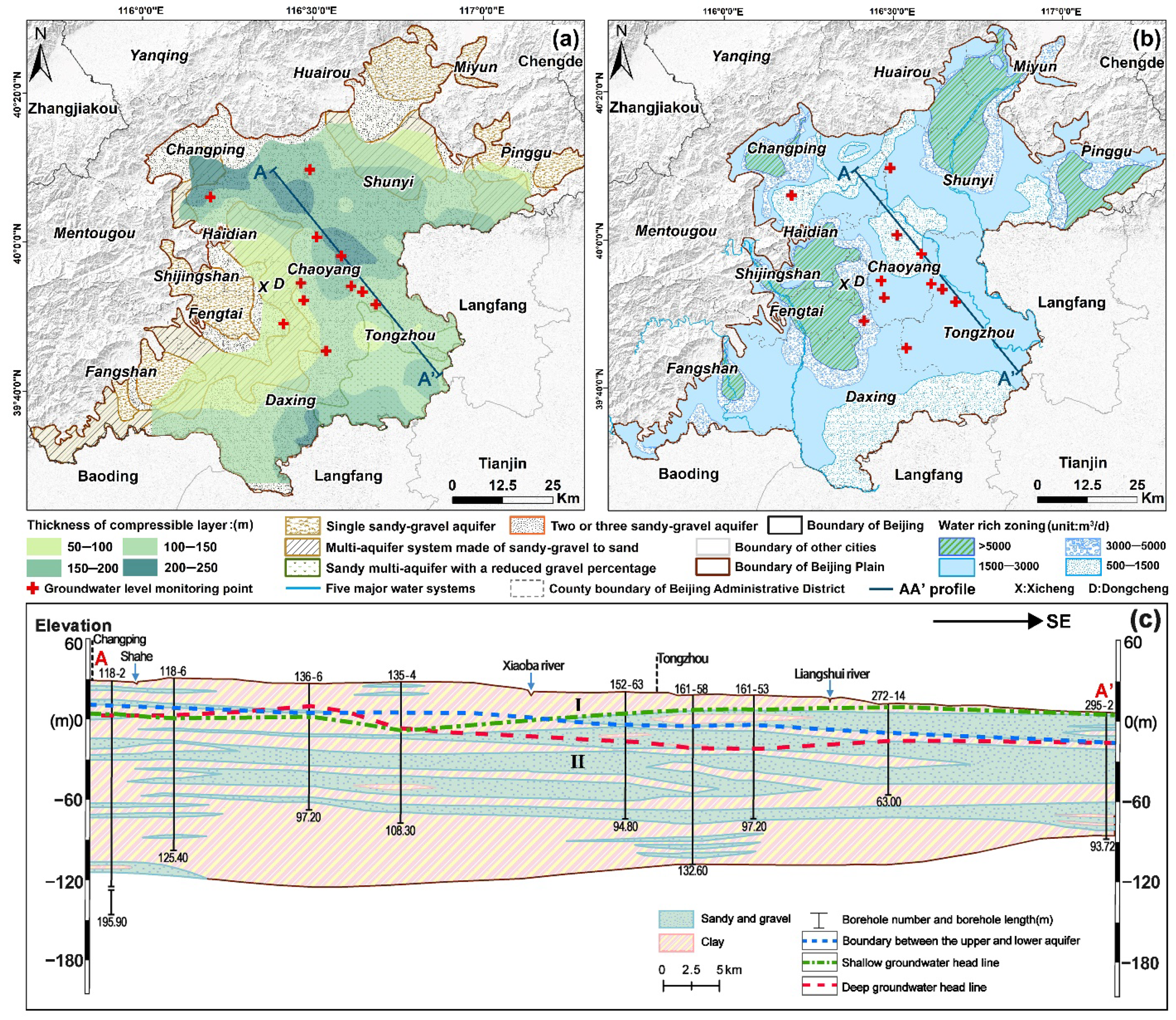
Figure 1. (a) Lithologic characteristics description of aquifer, the thickness of compressible clay layer and distribution of groundwater level monitoring points in the study area. (b) The distribution of water-rich zoning in Beijing plain, and water yield of single well when the precipitation is 5 m (unit:m3/d). (c) The map of Changping–Tongzhou district (AA’ profile line) hydrogeological profile.
Remotesensing 14 00991 g001
Figure 2. (a) Description of datasets coverage in the study area, in which the blue dotted rectangle represents the coverage of RadarSat-2 data in Beijing plain area. (b) For the RadarSat-2 satellite data set, the vertical baseline map of interference relative sets selected with temporal baseline less than 300 days and spatial baseline less than 300 meters.
Remotesensing 14 00991 g002
Figure 3. Flowchart of research method.
Remotesensing 14 00991 g003
Figure 4. (a) Linear regression results of InSAR vertical deformation and leveling from 2012 to 2013. (b) Linear regression results of InSAR vertical deformation and leveling from 2015 to 2016.
Remotesensing 14 00991 g004
Figure 5. (a) Annual average deformation velocity map of Beijing plain from January 2012 to October 2016 based on 46 RadarSat-2 images. (b) Cumulative deformation year by year at profile line AA’ in Figure 5a. (cg) The spatial evolution of cumulative deformation velocity (mm/yr) from 2012 to 2016 after IDW interpolation in space.
Remotesensing 14 00991 g005
Figure 6. Time series trend of cumulative surface deformation and hydraulic head change near groundwater level monitoring points.
Remotesensing 14 00991 g006
Figure 7. Spectral distribution of 20 signal RCs after MSSA decomposition, among which red dotted lines represent seasonal signals with periodic oscillations. (a) This represents the spectrum of RCs of the head change at GWL5 after decomposition. (b) This represents the spectrum of RCs of the deformation at GWL6 after decomposition. The deformation at this point is taken as the mean value of the vertical deformation of coherent points in the 100 m buffer zone near the GWL6.
Remotesensing 14 00991 g007
Figure 8. (a,b) Distribution of contribution rates of different frequencies and corresponding variances at GWL9. (c,d) The 95% confidence interval test was performed on the feature vectors associated with the main frequencies by MC-SSA.
Remotesensing 14 00991 g008
Figure 9. The seasonal components of head and deformation separated by MSSA. The solid blue line represents the mean value of seasonal components of all PS points in the 100 m buffer zone centered on every GWL monitoring point.
Remotesensing 14 00991 g009
Figure 10. The cross-correlation coefficient and lag time between seasonal deformation and seasonal hydraulic head were calculated by TLCC.
Remotesensing 14 00991 g010
Figure 11. The IDW interpolation results of elastic skeletal storativity coefficients of 11 monitoring wells.
Remotesensing 14 00991 g011
Figure 12. (a–c) According to equations in Section 3.4, the average change volume of TGWS, RGWS and UGWS during the study period. All volume changes are expressed as EWT (unit: mm).
Remotesensing 14 00991 g012
Figure 13. (ae) The evolution of UGWS depletion yearly from 2012 to 2016. (f) The TGWS results were verified and fitted with the results of Beijing Water Resources Bulletin.
Remotesensing 14 00991 g013
Figure 14. (a)The depletion of UGWS in profile A-A’. (b) Comparison of UGWS depletion and average total head change trend year by year. (DK: distance/km).
Remotesensing 14 00991 g014
Table 1. The division of major aquifers groups in the Beijing plain.
Aquifer GroupLithologyThickness (m)Depth of Bottom (m)
The first aquifer group
(Unconfined aquifer)
silt, silty sandy, and sandy clay15–1200–50
The second aquifer groupmultiple types of gravel, sand, and clay soil60–9580–100
The third aquifer groupmultiple types of gravel, sand, and clay soil65–120100–180
The fourth aquifer groupmainly sand200–300180–300
Table 2. Acquisition parameters of RadarSat-2.
SAR SensorRadarSat-2Polarization ModeVV
Orbit directionDescendingExternal DEMSRTM
Band (wavelength)C band (5.63 cm)Spatial resolution of SRTM90 m
Spatial resolution30 mWidth range150 km × 150 km
Return period24 daysTemporal baseline<300 d
Average incidence angle27.10°Spatial baseline<300 m
Number of images46
Temporal periodJanuary 2012–October 2016
Table 3. The elastic skeletal storativity coefficient calculated according to Equation (6).
Point NumberElastic Skeletal Storativity
(Ske)
Lag Time (Unit: Days)Thickness of Compressible Layer (Unit: m)
GWL10.249 × 10−360150–200
GWL20.563 × 10−3152150–200
GWL30.169 × 10−391100–150
GWL40.241 × 10−3244100–150
GWL50.201 × 10−3182100–150
GWL60.442 × 10−30150–200
GWL70.395 × 10−331200–250
GWL80.420 × 10−360150–200
GWL90.179 × 10−3213100–150
GWL100.719 × 10−3050–100
GWL110.423 × 10−331100–150
Publisher’s Note: MDPI stays neutral with regard to jurisdictional claims in published maps and institutional affiliations.