
Suitable Habitat Dynamics of Wintering Geese in a Large Floodplain Wetland: Insights from Flood Duration


Abstract
:
1. Introduction
2. Materials and Methods
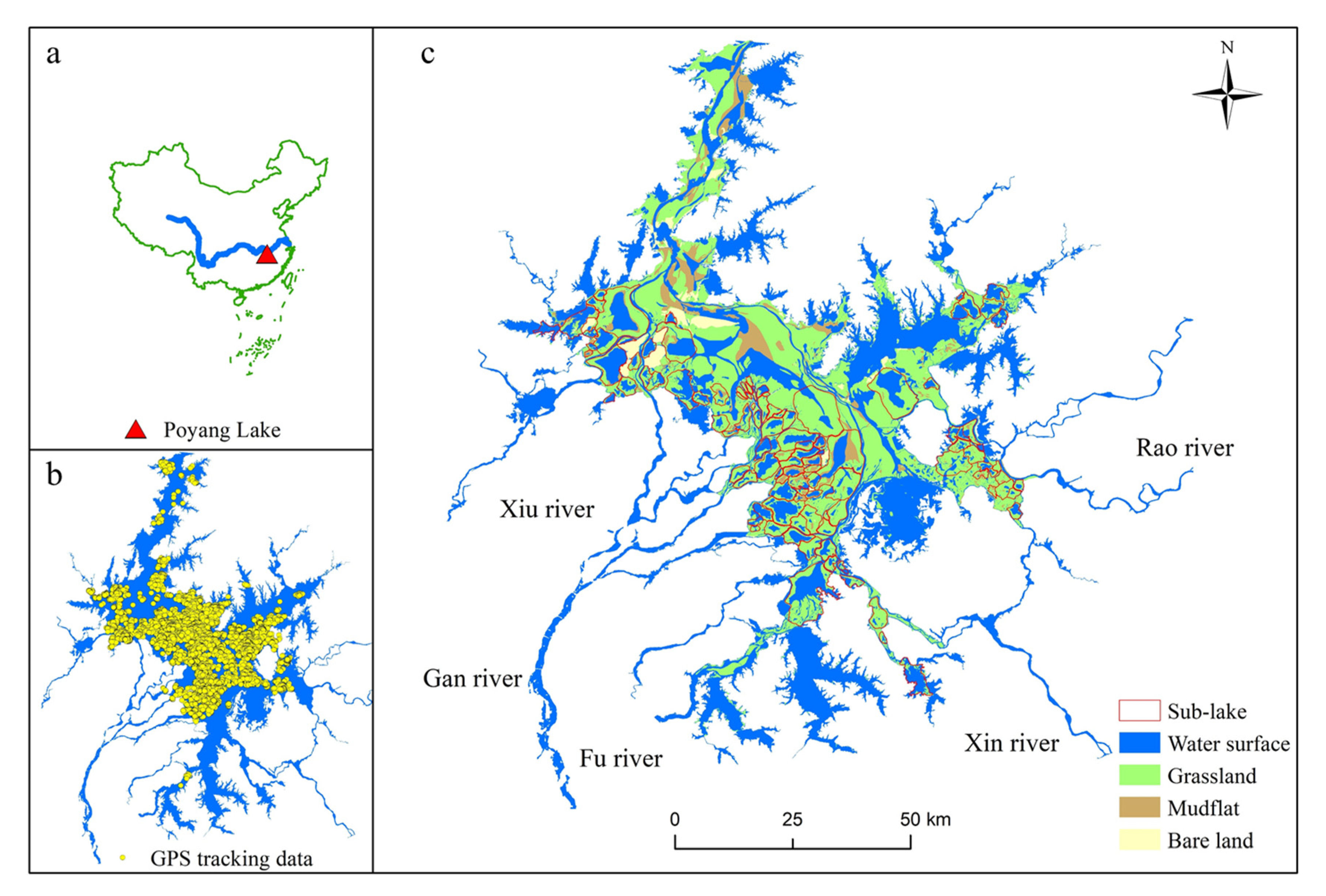
2.1. Study Area
2.2. Data
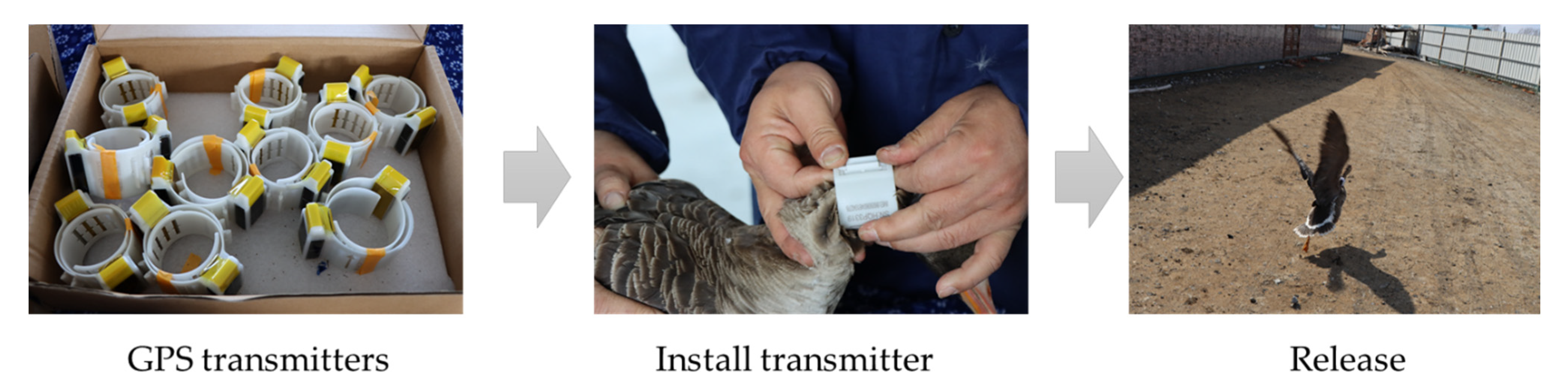
2.2.1. GPS Tracking Data
2.2.2. Synthetic Aperture Radar Data
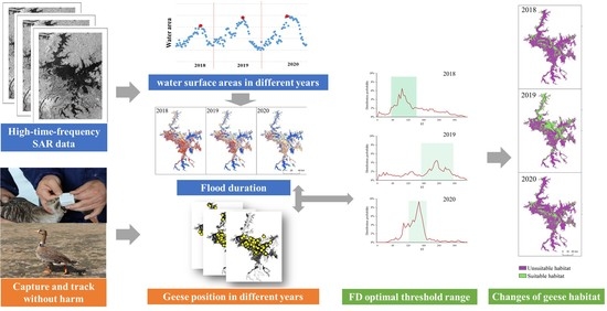
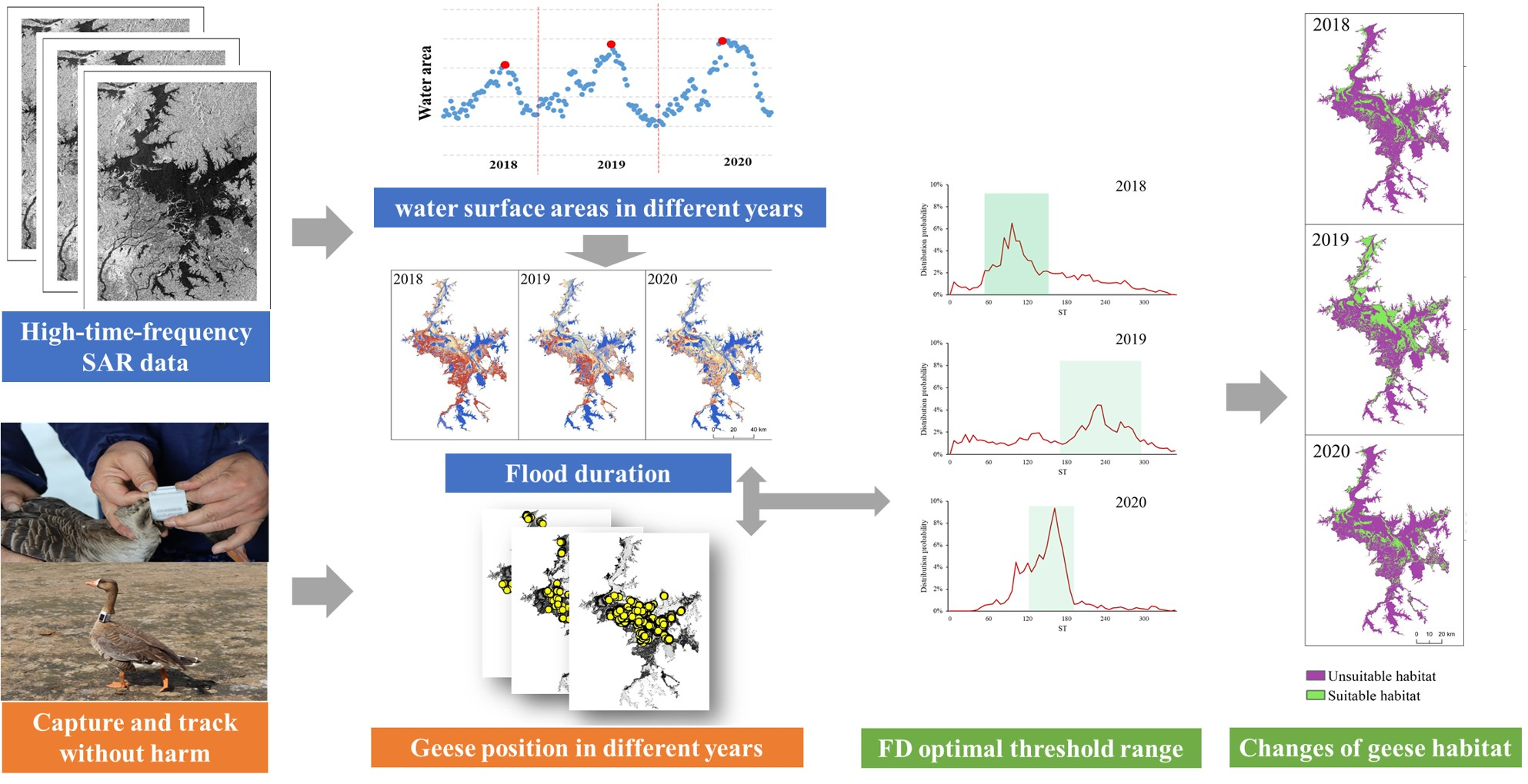
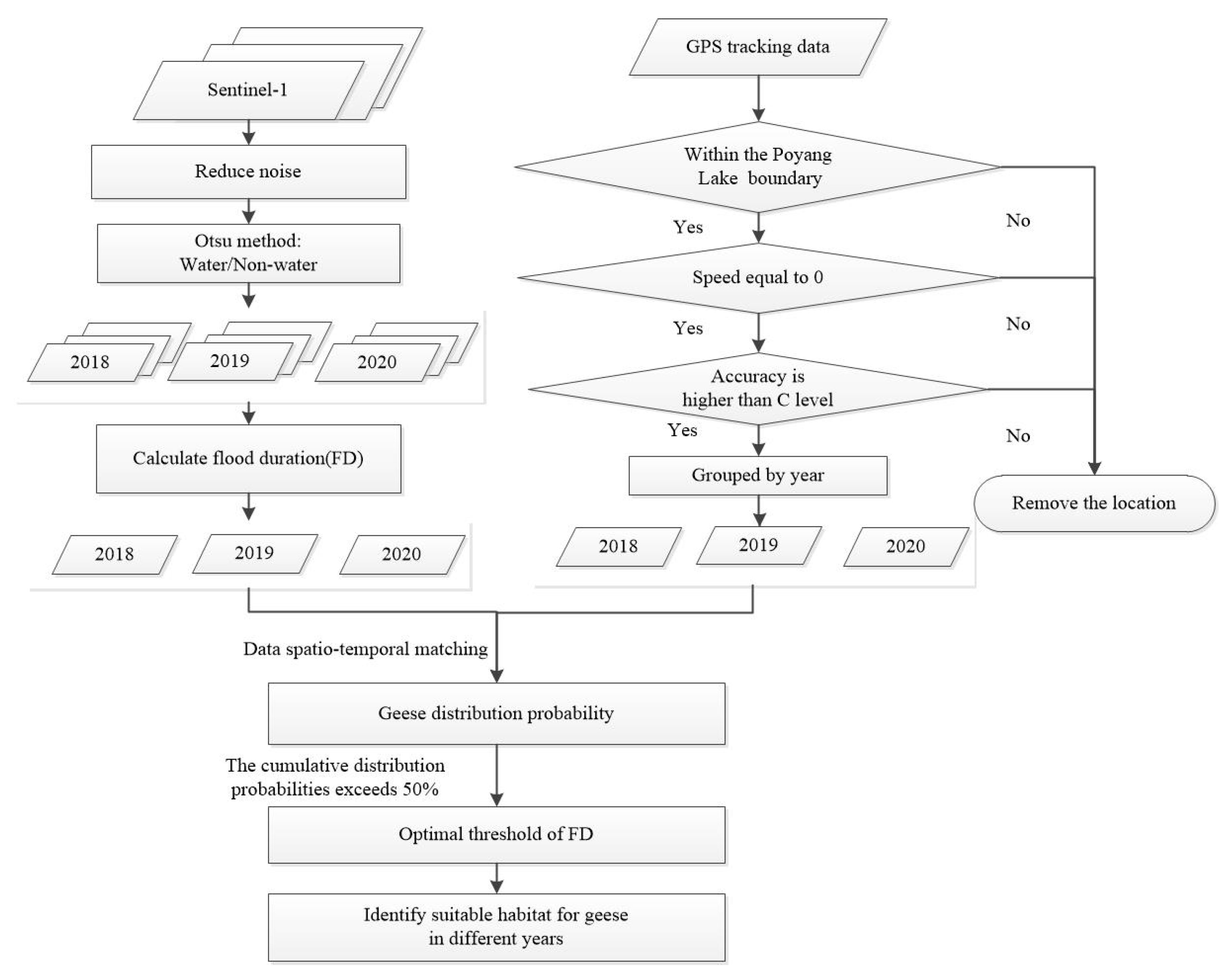
2.3. Method
2.3.1. Flood Duration Index
2.3.2. Geese Distribution Probability
2.3.3. Identification of Suitable Habitat
3. Results
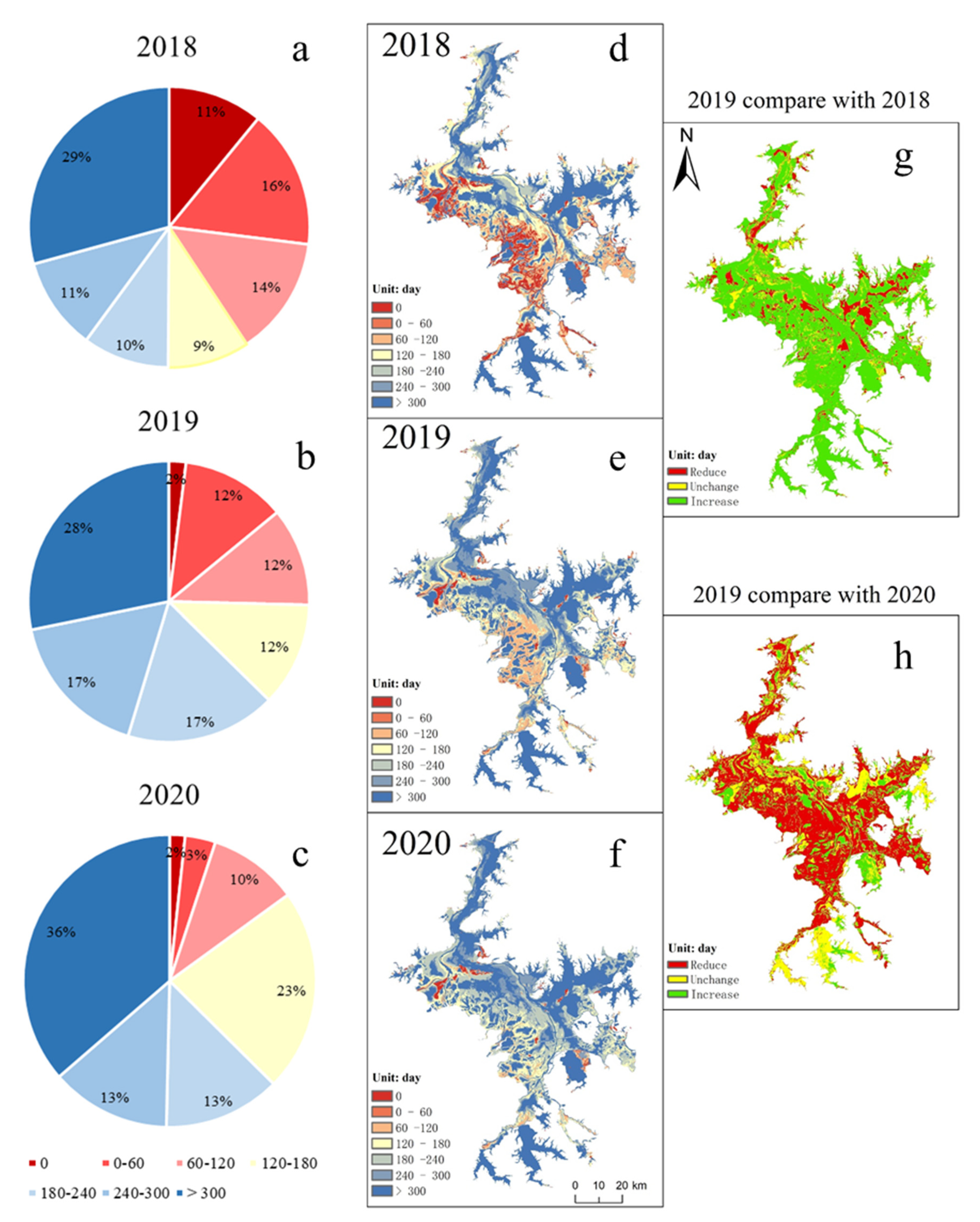
3.1. Flood Duration Index
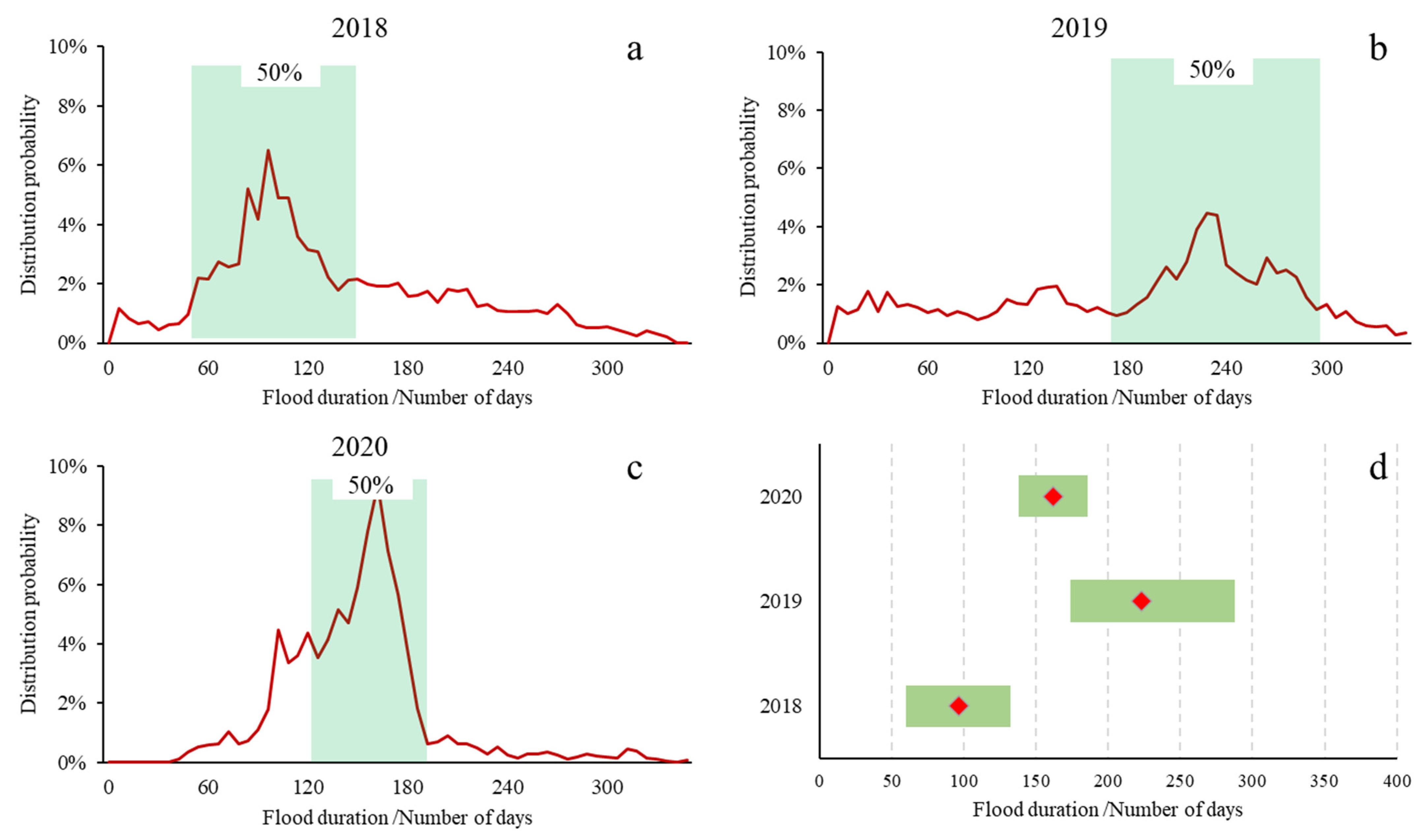
3.2. Response of Geese to Flood Duration Changes
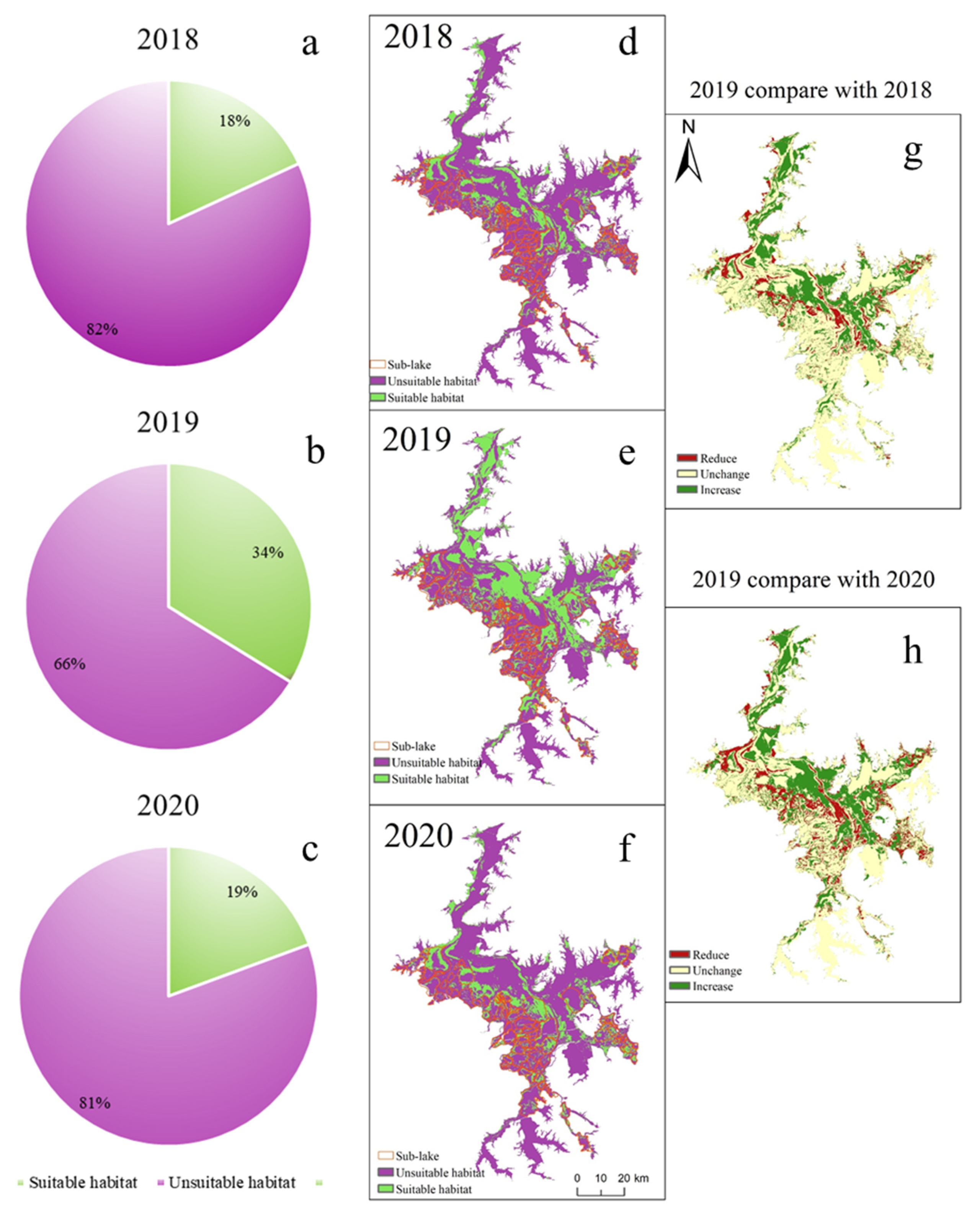
3.3. Temporal and Spatial Pattern Changes of Habitats
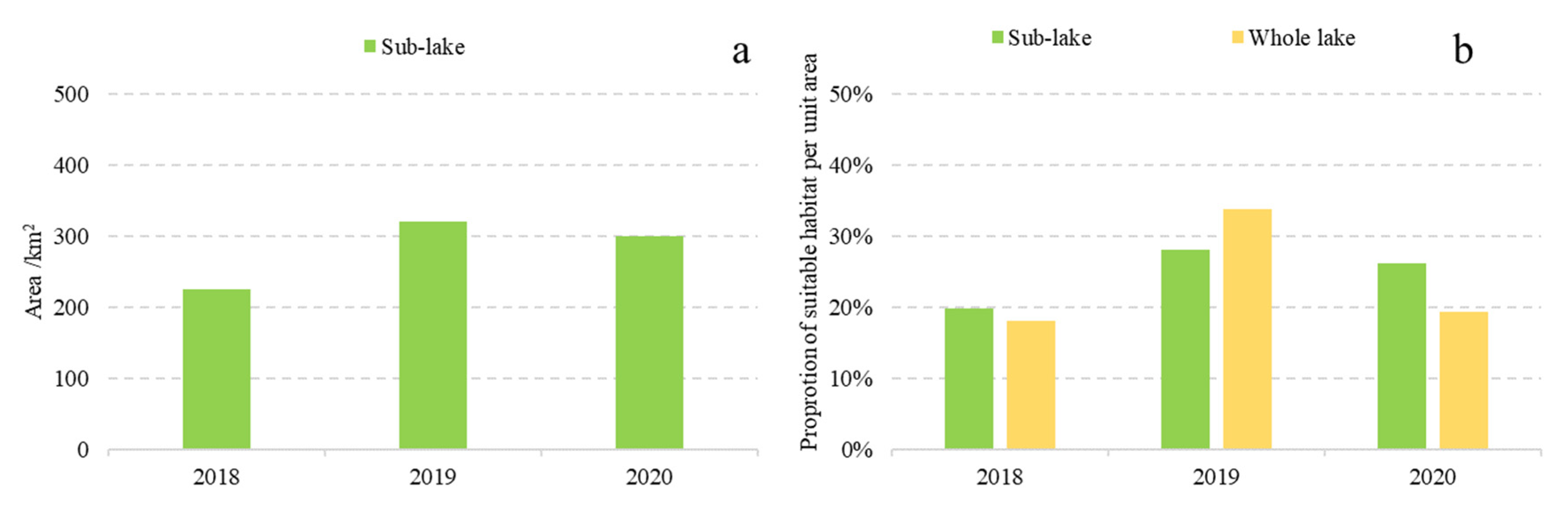
3.4. Importance of Sub-Lakes under Different Hydrological Conditions
4. Discussion
4.1. Characteristics and Application of the Flood Duration
4.2. Responses of Geese to Hydrological Variation
4.3. Conservation Implication
5. Conclusions
Supplementary Materials
Author Contributions
Funding
Data Availability Statement
Conflicts of Interest
References
- Wen, L.; Macdonald, R.; Morrison, T.; Hameed, T.; Saintilan, N.; Ling, J. From hydrodynamic to hydrological modelling: Investigating long-term hydrological regimes of key wetlands in the Macquarie Marshes, a semi-arid lowland floodplain in Australia. J. Hydrol. 2013, 500, 45–61. [Google Scholar] [CrossRef]
- Guan, L.; Wen, L.; Feng, D.; Zhang, H.; Lei, G. Delayed flood recession in central Yangtze floodplains can cause significant food shortages for wintering geese: Results of inundation experiment. Environ. Manag. 2014, 54, 1331–1341. [Google Scholar] [CrossRef]
- Xia, S.; Liu, Y.; Wang, Y.; Chen, B.; Jia, Y.; Liu, G.; Yu, X.; Wen, L. Wintering waterbirds in a large river floodplain: Hydrological connectivity is the key for reconciling development and conservation. Sci. Total Environ. 2016, 573, 645–660. [Google Scholar] [CrossRef] [PubMed]
- Acreman, M.; Fisher, J.; Stratford, C.; Mould, D.; Mountford, J. Hydrological science and wetland restoration: Some case studies from Europe. Hydrol. Earth Syst. Sci. 2007, 11, 158–169. [Google Scholar] [CrossRef] [Green Version]
- Zhang, P.Y.; Zou, Y.A.; Xie, Y.H.; Zhang, H.; Liu, X.K.; Gao, D.L.; Yi, F.Y. Shifts in distribution of herbivorous geese relative to hydrological variation in East Dongting Lake wetland, China. Sci. Total Environ. 2018, 636, 30–38. [Google Scholar] [CrossRef] [PubMed]
- Teng, J.; Xia, S.; Liu, Y.; Yu, X.; Duan, H.; Xiao, H.; Zhao, C. Assessing habitat suitability for wintering geese by using Normalized Difference Water Index (NDWI) in a large floodplain wetland, China. Ecol. Indic. 2021, 122, 107260. [Google Scholar] [CrossRef]
- Yao, S.; Li, X.; Liu, C.; Zhang, J.; Li, Y.; Gan, T.; Liu, B.; Kuang, W. New assessment indicator of habitat suitability for migratory bird in wetland based on hydrodynamic model and vegetation growth threshold. Ecol. Indic. 2020, 117, 106556. [Google Scholar] [CrossRef]
- Hu, Z.; Ge, G.; Liu, C. Response of wintering migratory birds to hydrological processes in Poyang Lake. J. Nat. Resour. 2014, 29, 1770–1779. [Google Scholar]
- Najibi, N.; Devineni, N. Recent trends in the frequency and duration of global floods. Earth Syst. Dyn. 2018, 9, 757–783. [Google Scholar] [CrossRef] [Green Version]
- Javelle, P.; Ouarda, T.B.; Lang, M.; Bobée, B.; Galéa, G.; Grésillon, J.-M. Development of regional flood-duration–frequency curves based on the index-flood method. J. Hydrol. 2002, 258, 249–259. [Google Scholar] [CrossRef]
- Zhang, Q.; Werner, A.D. Hysteretic relationships in inundation dynamics for a large lake–floodplain system. J. Hydrol. 2015, 527, 160–171. [Google Scholar] [CrossRef]
- Gharari, S.; Razavi, S. A review and synthesis of hysteresis in hydrology and hydrological modeling: Memory, path-dependency, or missing physics? J. Hydrol. 2018, 566, 500–519. [Google Scholar] [CrossRef]
- Rättich, M.; Martinis, S.; Wieland, M. Automatic flood duration estimation based on multi-sensor satellite data. Remote Sens. 2020, 12, 643. [Google Scholar] [CrossRef] [Green Version]
- Yang, M.; Xia, S.; Liu, G.; Wang, M.; Ding, Z.; Yu, P.; Tang, X. Effect of hydrological variation on vegetation dynamics for wintering waterfowl in China’s Poyang Lake Wetland. Glob. Ecol. Conserv. 2020, 22, e01020. [Google Scholar] [CrossRef]
- Feng, L.; Hu, C.; Chen, X.; Cai, X.; Tian, L.; Gan, W. Assessment of inundation changes of Poyang Lake using MODIS observations between 2000 and 2010. Remote Sens. Environ. 2012, 121, 80–92. [Google Scholar] [CrossRef]
- Jiang, W.; He, G.; Long, T.; Ni, Y.; Liu, H.; Peng, Y.; Lv, K.; Wang, G. Multilayer perceptron neural network for surface water extraction in Landsat 8 OLI satellite images. Remote Sens. 2018, 10, 755. [Google Scholar] [CrossRef] [Green Version]
- Yang, X.; Qin, Q.; Grussenmeyer, P.; Koehl, M. Urban surface water body detection with suppressed built-up noise based on water indices from Sentinel-2 MSI imagery. Remote Sens. Environ. 2018, 219, 259–270. [Google Scholar] [CrossRef]
- Bioresita, F.; Puissant, A.; Stumpf, A.; Malet, J.-P. A method for automatic and rapid mapping of water surfaces from sentinel-1 imagery. Remote Sens. 2018, 10, 217. [Google Scholar] [CrossRef] [Green Version]
- Konapala, G.; Kumar, S.V.; Ahmad, S.K. Exploring Sentinel-1 and Sentinel-2 diversity for flood inundation mapping using deep learning. ISPRS J. Photogramm. Remote Sens. 2021, 180, 163–173. [Google Scholar] [CrossRef]
- Wong, B.A.; Thomas, C.; Halpin, P. Automating offshore infrastructure extractions using synthetic aperture radar & Google Earth Engine. Remote Sens. Environ. 2019, 233, 111412. [Google Scholar]
- Jacoby, D.M.; Freeman, R. Emerging network-based tools in movement ecology. Trends Ecol. Evol. 2016, 31, 301–314. [Google Scholar] [CrossRef] [PubMed]
- Clausen, K.K.; Madsen, J.; Cottaar, F.; Kuijken, E.; Verscheure, C. Highly dynamic wintering strategies in migratory geese: Coping with environmental change. Glob. Chang. Biol. 2018, 24, 3214–3225. [Google Scholar] [CrossRef] [PubMed] [Green Version]
- Si, Y.L.; Xin, Q.C.; Prins, H.H.T.; de Boer, W.F.; Gong, P. Improving the quantification of waterfowl migration with remote sensing and bird tracking. Sci. Bull. 2015, 60, 1984–1993. [Google Scholar] [CrossRef] [Green Version]
- Fraser, K.C.; Shave, A.; Savage, A.; Ritchie, A.; Bell, K.; Siegrist, J.; Ray, J.D.; Applegate, K.; Pearman, M. Determining fine-scale migratory connectivity and habitat selection for a migratory songbird by using new GPS technology. J. Avian Biol. 2017, 48, 339–345. [Google Scholar] [CrossRef]
- Sun, C.; König, H.J.; Uthes, S.; Chen, C.; Li, P.; Hemminger, K. Protection effect of overwintering water bird habitat and defining the conservation priority area in Poyang Lake wetland, China. Environ. Res. Lett. 2020, 15, 125013. [Google Scholar] [CrossRef]
- Donnelly, J.P.; King, S.L.; Silverman, N.L.; Collins, D.P.; Carrera-Gonzalez, E.M.; Lafón-Terrazas, A.; Moore, J.N. Climate and human water use diminish wetland networks supporting continental waterbird migration. Glob. Chang. Biol. 2020, 26, 2042–2059. [Google Scholar] [CrossRef] [PubMed] [Green Version]
- Feng, L.; Han, X.; Hu, C.; Chen, X. Four decades of wetland changes of the largest freshwater lake in China: Possible linkage to the Three Gorges Dam? Remote Sens. Environ. 2016, 176, 43–55. [Google Scholar] [CrossRef]
- Han, X.; Feng, L.; Hu, C.; Chen, X. Wetland changes of China’s largest freshwater lake and their linkage with the Three Gorges Dam. Remote Sens. Environ. 2018, 204, 799–811. [Google Scholar] [CrossRef]
- Guan, L.; Lei, J.; Zuo, A.; Zhang, H.; Lei, G.; Wen, L. Optimizing the timing of water level recession for conservation of wintering geese in Dongting Lake, China. Ecol. Eng. 2016, 88, 90–98. [Google Scholar] [CrossRef]
- Yali, S. Mapping Flood Recessional Grasslands Grazed by Overwintering Geese: An Application of Multi-Temporal Remote Sensing; International Institute for Geo-Information Science and Earth Observation: Enschede, The Netherlands, 2006. [Google Scholar]
- Hu, B.; Hu, X.; Nie, X.; Zhang, X.; Wu, N.; Hong, Y.; Qin, H.M. Seasonal and inter-annual community structure characteristics of zooplankton driven by water environment factors in a sub-lake of Lake Poyang, China. PeerJ 2019, 7, e7590. [Google Scholar] [CrossRef] [Green Version]
- Qi, S.; Liu, Y.; Yu, X.; Liao, F. Effect of “Lake Enclosed in Autumn” on the habitat of winter bird in Poyang Lake. Resour. Environ. Yangtze Basin 2011, 1, 18–21. [Google Scholar]
- Jia, H.; Ji, H.; Yu, J.; Meng, X. Spatial and temporal variations in coastline morphology along Ganjiang-Poyang Lake: Sediment supply as a cause of variability. Environ. Earth Sci. 2019, 78, 1–12. [Google Scholar] [CrossRef]
- Feng, L.; Hu, C.; Chen, X.; Li, R.; Tian, L.; Murch, B. MODIS observations of the bottom topography and its inter-annual variability of Poyang Lake. Remote Sens. Environ. 2011, 115, 2729–2741. [Google Scholar] [CrossRef]
- Mei, X.; Dai, Z.; Du, J.; Chen, J. Linkage between Three Gorges Dam impacts and the dramatic recessions in China’s largest freshwater lake, Poyang Lake. Sci. Rep. 2015, 5, 1–9. [Google Scholar] [CrossRef] [PubMed] [Green Version]
- Li, B.; Yang, G.; Wan, R.; Dai, X.; Zhang, Y. Comparison of random forests and other statistical methods for the prediction of lake water level: A case study of the Poyang Lake in China. Hydrol. Res. 2016, 47, 69–83. [Google Scholar] [CrossRef] [Green Version]
- Liu, J.; Chen, Y.; Li, M.; Liu, B.; Liu, X.; Wu, Z.; Cai, Y.; Xu, J.; Wang, J. Water-level fluctuations are key for phytoplankton taxonomic communities and functional groups in Poyang Lake. Ecol. Indic. 2019, 104, 470–478. [Google Scholar] [CrossRef]
- Liu, X.; Zhang, Q.; Li, Y.; Tan, Z.; Werner, A.D. Satellite image-based investigation of the seasonal variations in the hydrological connectivity of a large floodplain (Poyang Lake, China). J. Hydrol. 2020, 585, 124810. [Google Scholar] [CrossRef]
- Hu, Z.; Zhang, Z.; Liu, Y.; Ji, W.; Ge, G. The function and significance of the Shallow-Lakes in the Poyang Lake wetland ecosystem. Jiangxi Hydraul. Sci. Technol. 2015, 41, 317–323. [Google Scholar]
- Wang, W.; Fraser, J.D.; Chen, J. Distribution and long-term population trends of wintering waterbirds in Poyang Lake, China. Wetlands 2019, 39, 125–135. [Google Scholar] [CrossRef]
- Liu, H.; Yuan, H.; Wang, S.; Zheng, L.; Liao, M. Spatiotemporal Dynamics of Water Body Changes and Their Influencing Factors in the Seasonal Lakes of the Poyang Lake Region. Water 2021, 13, 1539. [Google Scholar] [CrossRef]
- Chen, B.Q.; Xiao, X.M.; Ye, H.C.; Ma, J.; Doughty, R.; Li, X.P.; Zhao, B.; Wu, Z.X.; Sun, R.; Dong, J.W.; et al. Mapping Forest and Their Spatial-Temporal Changes From 2007 to 2015 in Tropical Hainan Island by Integrating ALOS/ALOS-2 L-Band SAR and Landsat Optical Images. IEEE J. Sel. Top. Appl. Earth Obs. Remote Sens. 2018, 11, 852–867. [Google Scholar] [CrossRef]
- Abdikan, S.; Sanli, F.B.; Ustuner, M.; Calò, F. Land cover mapping using sentinel-1 SAR data. Int. Arch. Photogramm. Remote Sens. Spat. Inf. Sci. 2016, 41, 757. [Google Scholar] [CrossRef] [Green Version]
- Zhao, C.; Qin, C.-Z.; Teng, J. Mapping large-area tidal flats without the dependence on tidal elevations: A case study of Southern China. ISPRS J. Photogramm. Remote Sens. 2020, 159, 256–270. [Google Scholar] [CrossRef]
- Gulácsi, A.; Kovács, F. Sentinel-1-imagery-based high-resolution water cover detection on wetlands, Aided by Google Earth Engine. Remote Sens. 2020, 12, 1614. [Google Scholar] [CrossRef]
- Otsu, N. A threshold selection method from gray-level histograms. IEEE Trans. Syst. Man Cybern. 1979, 9, 62–66. [Google Scholar] [CrossRef] [Green Version]
- Wei, J.; Xin, Q.; Ji, L.; Gong, P.; Si, Y. A new satellite-based indicator to identify spatiotemporal foraging areas for herbivorous waterfowl. Ecol. Indic. 2019, 99, 83–90. [Google Scholar] [CrossRef]
- Yu, H.; Wang, X.; Cao, L.; Zhang, L.; Jia, Q.; Lee, H.; Xu, Z.; Liu, G.; Xu, W.; Hu, B. Are declining populations of wild geese in China ‘prisoners’ of their natural habitats? Curr. Biol. 2017, 27, R376–R377. [Google Scholar] [CrossRef] [PubMed]
- De Luca, D.W.; Phillipps, G.P.; Machaga, S.J.; Davenport, T.R.B. Home range, core areas and movement in the ‘critically endangered’ kipunji (Rungwecebus kipunji) in southwest Tanzania. Afr. J. Ecol. 2010, 48, 895–904. [Google Scholar] [CrossRef]
- Cumming, G.S.; Paxton, M.; King, J.; Beuster, H. Foraging guild membership explains variation in waterbird responses to the hydrological regime of an arid-region flood-pulse river in Namibia. Freshw. Biol. 2012, 57, 1202–1213. [Google Scholar] [CrossRef]
- Teng, J.; Xia, S.; Liu, Y.; Cui, P.; Chen, J.; Si, W.; Duan, H.; Yu, X. Differences of Regulative Flexibility between Hydrological Isolated and Connected Lakes in a Large Floodplain: Insight from Inundation Dynamics and Landscape Heterogeneity. Water 2020, 12, 991. [Google Scholar] [CrossRef] [Green Version]
- Jia, Q.; Wang, X.; Zhang, Y.; Cao, L.; Fox, A.D. Drivers of waterbird communities and their declines on Yangtze River floodplain lakes. Biol. Conserv. 2018, 218, 240–246. [Google Scholar] [CrossRef]
- Markert, K.N.; Markert, A.M.; Mayer, T.; Nauman, C.; Haag, A.; Poortinga, A.; Bhandari, B.; Thwal, N.S.; Kunlamai, T.; Chishtie, F. Comparing sentinel-1 surface water mapping algorithms and radiometric terrain correction processing in southeast asia utilizing google earth engine. Remote Sens. 2020, 12, 2469. [Google Scholar] [CrossRef]
- Zhang, L.; Yin, J.; Jiang, Y.; Wang, H. Relationship between the hydrological conditions and the distribution of vegetation communities within the Poyang Lake National Nature Reserve, China. Ecol. Inform. 2012, 11, 65–75. [Google Scholar] [CrossRef]
- Yuan, S.B.; Yang, Z.D.; Liu, X.Q.; Wang, H.Z. Water level requirements of a Carex hygrophyte in Yangtze floodplain lakes. Ecol. Eng. 2019, 129, 29–37. [Google Scholar] [CrossRef]
- Wang, X.; Zhang, Y.; Zhao, M.; Cao, L.; Fox, A.D. The benefits of being big: Effects of body size on energy budgets of three wintering goose species grazing Carex beds in the Yangtze River floodplain, China. J. Ornithol. 2013, 154, 1095–1103. [Google Scholar] [CrossRef]
- Zhu, Z.; Huai, W.; Yang, Z.; Li, D.; Wang, Y. Assessing habitat suitability and habitat fragmentation for endangered Siberian cranes in Poyang Lake region, China. Ecol. Indic. 2021, 125, 107594. [Google Scholar] [CrossRef]
- Cui, Y.L.; Dong, B.; Chen, L.N.; Gao, X.; Cui, Y.H. Study on habitat suitability of overwintering cranes based on landscape pattern changea case study of typical lake wetlands in the middle and lower reaches of the Yangtze River. Environ. Sci. Pollut. Res. 2019, 26, 14962–14975. [Google Scholar] [CrossRef]
- Royan, A.; Hannah, D.M.; Reynolds, S.J.; Noble, D.G.; Sadler, J.P. River birds’ response to hydrological extremes: New vulnerability index and conservation implications. Biol. Conserv. 2014, 177, 64–73. [Google Scholar] [CrossRef] [Green Version]
- Zhang, P.; Zou, Y.; Xie, Y.; Zhang, S.; Zhu, F.; Chen, X.; Li, F.; Deng, Z.; Yao, Y.; Song, Y. Phenological mismatch caused by water regime change may explain the population variation of the vulnerable lesser white-fronted goose in east Dongting Lake, China. Ecol. Indic. 2021, 127, 107776. [Google Scholar] [CrossRef]
- Jankowiak, Ł.; Ławicki, Ł. Marginal habitats as important refugia for riparian birds during flood years. Bird Study 2014, 61, 125–129. [Google Scholar] [CrossRef]


| Type | The Cumulative Distribution Probabilities (CDP) |
|---|---|
| Suitable habitats | CDP Exceeds 50% |
| Unsuitable habitats | Others |
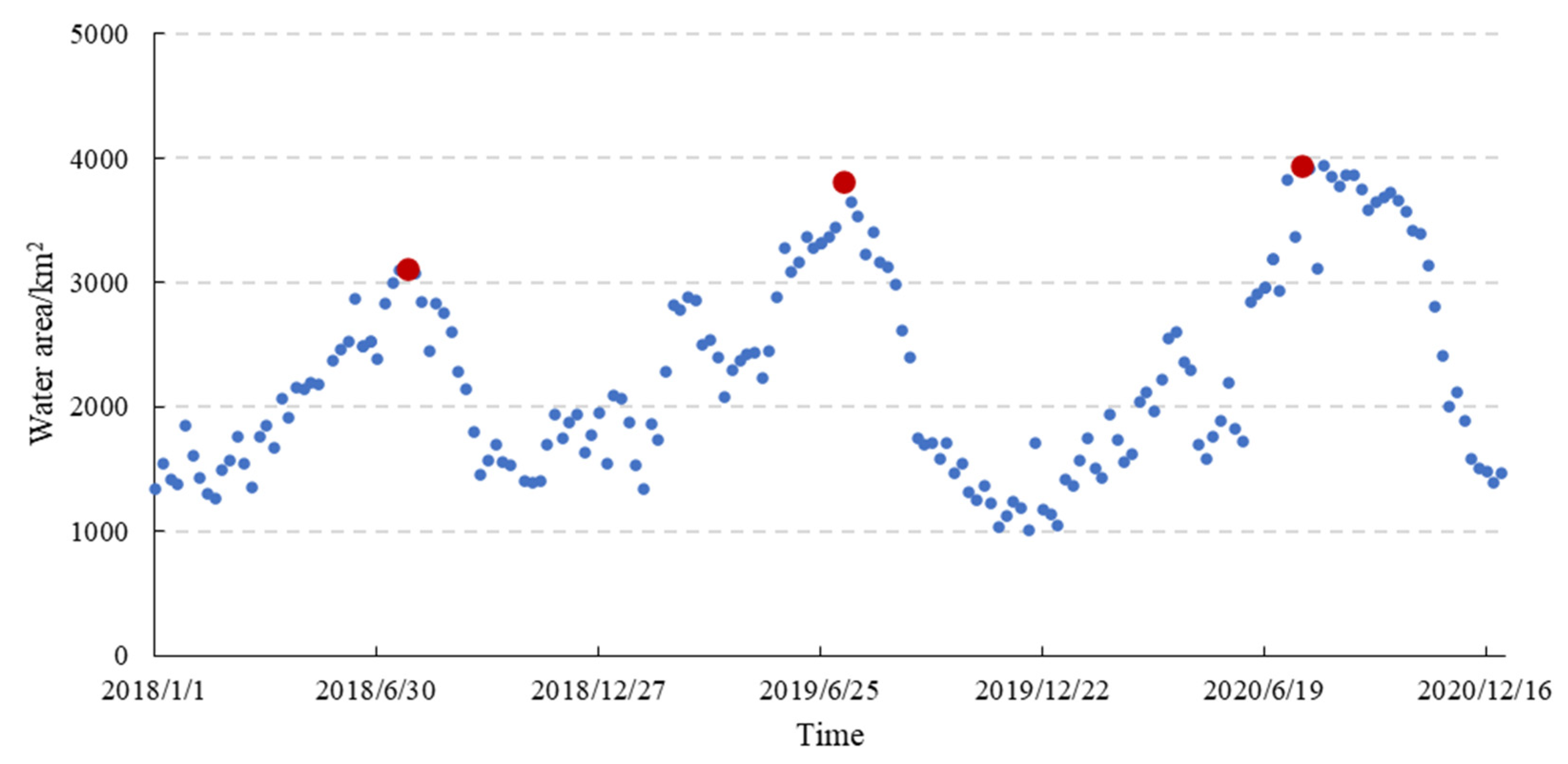
| Year | Maximum Waterbody Area | Corresponding Date | Minimum Waterbody Area | Corresponding Date | Inundation Areas |
|---|---|---|---|---|---|
| 2018 | 3115 km2 | July 25 | 1266 km2 | February 19 | 1849 km2 |
| 2019 | 3817 km2 | July 14 | 1005 km2 | December 11 | 2811 km2 |
| 2020 | 3941 km2 | July 20 | 1365 km2 | January 16 | 2576 km2 |
| Year | The Highest Distribution Probability | CDP > 50% | ||
|---|---|---|---|---|
| The Highest Probability | Flood Duration Range | Variation | Flood Duration Range | |
| 2018 | 6.52% | 96 | 60–132 | 72 |
| 2019 | 4.45% | 223 | 174–288 | 114 |
| 2020 | 9.36% | 162 | 138–186 | 48 |
Publisher’s Note: MDPI stays neutral with regard to jurisdictional claims in published maps and institutional affiliations. |
© 2022 by the authors. Licensee MDPI, Basel, Switzerland. This article is an open access article distributed under the terms and conditions of the Creative Commons Attribution (CC BY) license (https://creativecommons.org/licenses/by/4.0/).
Share and Cite
Teng, J.; Yu, X.; Xia, S.; Liu, Y. Suitable Habitat Dynamics of Wintering Geese in a Large Floodplain Wetland: Insights from Flood Duration. Remote Sens. 2022, 14, 952. https://doi.org/10.3390/rs14040952
Teng J, Yu X, Xia S, Liu Y. Suitable Habitat Dynamics of Wintering Geese in a Large Floodplain Wetland: Insights from Flood Duration. Remote Sensing. 2022; 14(4):952. https://doi.org/10.3390/rs14040952
Chicago/Turabian StyleTeng, Jiakun, Xiubo Yu, Shaoxia Xia, and Yu Liu. 2022. "Suitable Habitat Dynamics of Wintering Geese in a Large Floodplain Wetland: Insights from Flood Duration" Remote Sensing 14, no. 4: 952. https://doi.org/10.3390/rs14040952
APA StyleTeng, J., Yu, X., Xia, S., & Liu, Y. (2022). Suitable Habitat Dynamics of Wintering Geese in a Large Floodplain Wetland: Insights from Flood Duration. Remote Sensing, 14(4), 952. https://doi.org/10.3390/rs14040952