

Evaluating the Hydrus-1D Model Optimized by Remote Sensing Data for Soil Moisture Simulations in the Maize Root Zone

 ,
,
Abstract
1. Introduction
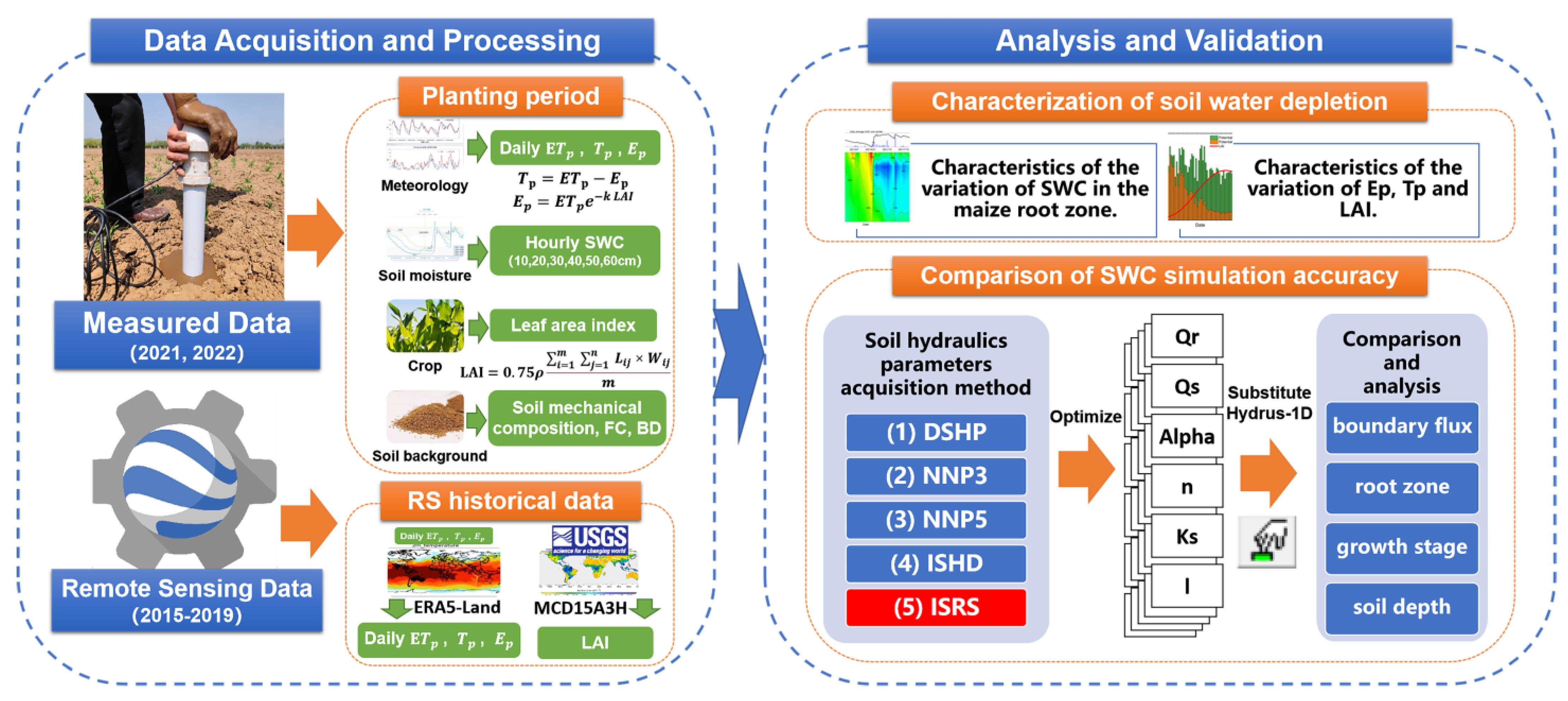
2. Methods
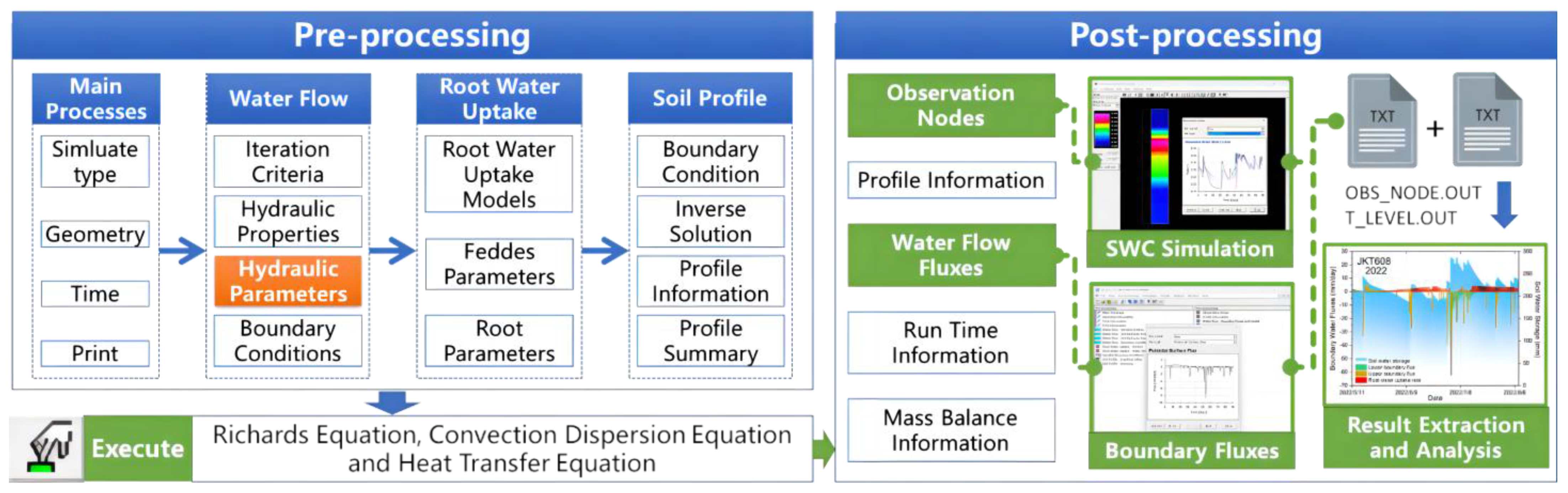
2.1. Hydrus-1D Model
- Theoretical equations for water flow motion
- Calculation of potential transpiration rate
- Calculation of the water uptake rate of the maize root system
- Model boundary parameter configuration
2.2. Methods for Obtaining Soil Hydraulics Parameters
- Default soil hydrodynamic parameters (DSHP) were used to determine the soil texture type. Based on the results of [31], the Hydrus-1D model provided the average soil hydrodynamic parameters for 12 soil texture types as optional default parameters. The soil texture in the root zone of maize in the different years in this study was clay loam (Table 2).
- Neural network prediction using three soil mechanical composition parameters (NNP3). Soil particle size ratios (ratios of sand, silt, and clay particles; %) were used to estimate five soil hydraulic parameters (, , , α, and ) for each soil depth. The soil pore connectivity parameter () was set to the default value of 0.5.
- Neural network prediction using five soil mechanical composition parameters (NNP5). Five soil hydraulic parameters (, , , α, and ) were estimated for each soil depth using the soil particle size ratio (ratio of sand, silt, and clay particles; %), soil field water capacity (SWC at 33 kPa; %), and soil bulk density (g/cm3) as inputs. The soil pore connectivity parameter () was set to 0.5.
- Inverse solutions from measured historical data (ISHD). We selected all measured data (meteorological, soil moisture, and LAI) from the JKT363 plot during the growth period for the inverse solution of the six soil hydraulic parameters (, , , α, , and ). The initial values of each parameter were set to the default values for the clay loam soil texture. The inverse solution module of Hydrus-1D allows the optimization of a maximum of 15 parameters; simultaneous optimization of excessive parameters is not recommended [50]. A hierarchical approach was used to optimize the parameters. The soil depths were optimized from shallow to deep in the order of six parameters for that layer depth; the default parameters were replaced with the optimized parameters.
- Inverse solution from historical remote sensing data (ISRS). This process was the same as that of the historical data inverse solution process. Remote sensing data were used instead of measured historical data for inverse parameter solutions. This is because the division of the soil depth in the reanalysis data is difficult to match with that of the SWC sensor. We regarded the depth of 0–100 cm as a whole. Only one inverse solution was performed for each year of remote sensing data.
2.3. Model Evaluation Metrics
2.4. Model Implementation and Analysis
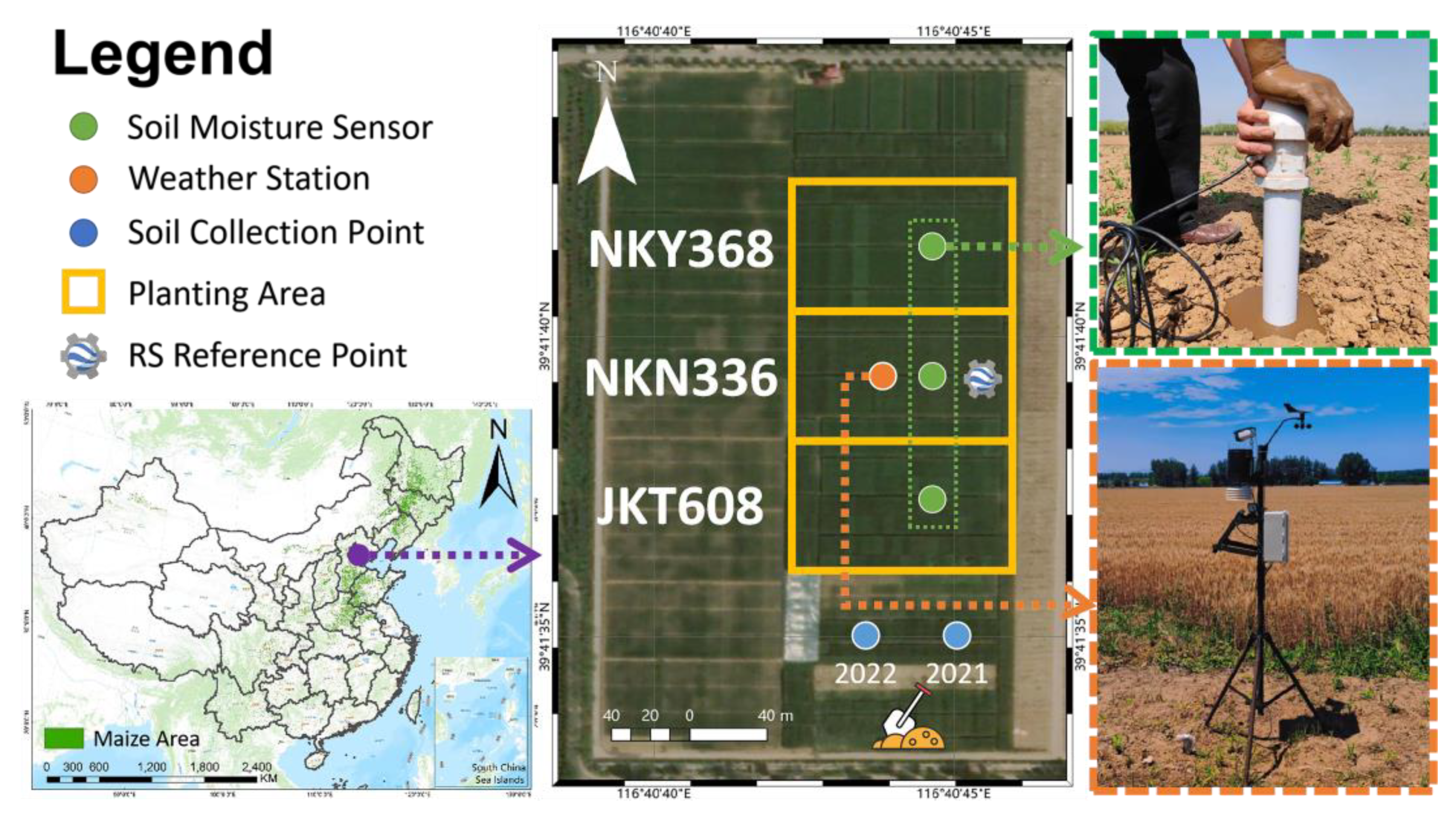
3. Experimental Area
4. Data Acquisition and Analysis
4.1. Acquisition and Processing of Measured Data
- Soil background data
- Soil moisture data
- Meteorological data
- Leaf area index data
- Maize phenological data
4.2. Remote Sensing Data Acquisition and Processing
4.3. Soil Hydraulic Parameter Benchmarks
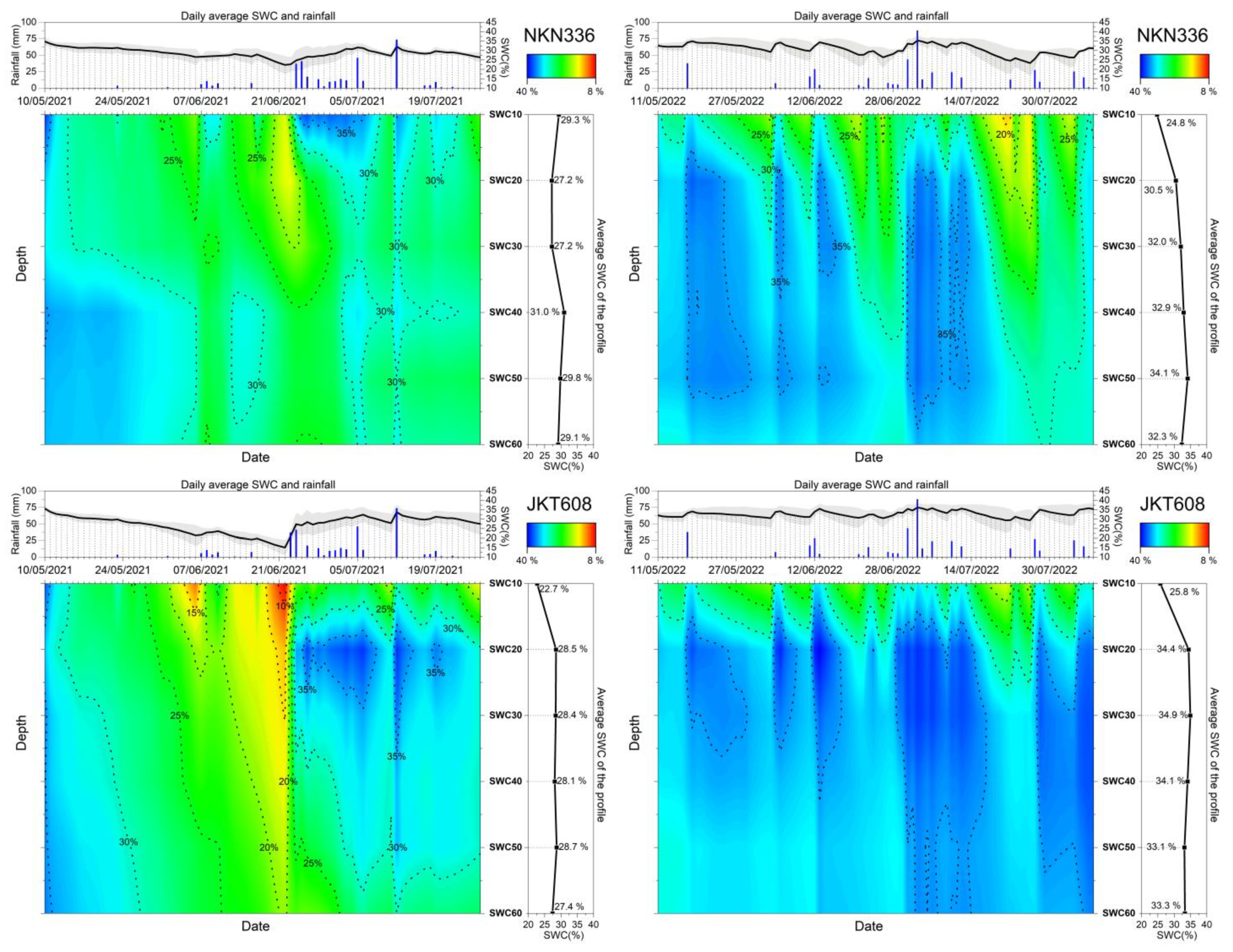
4.4. Data Analysis
- Statistical characteristics of the environment in the maize-growing areas
- Statistical characteristics of remote sensing data in maize growing areas
- Characteristics of SWC variation in the maize root zone
- Characteristics of evapotranspiration and LAI changes during maize cultivation
5. Results and Discussion
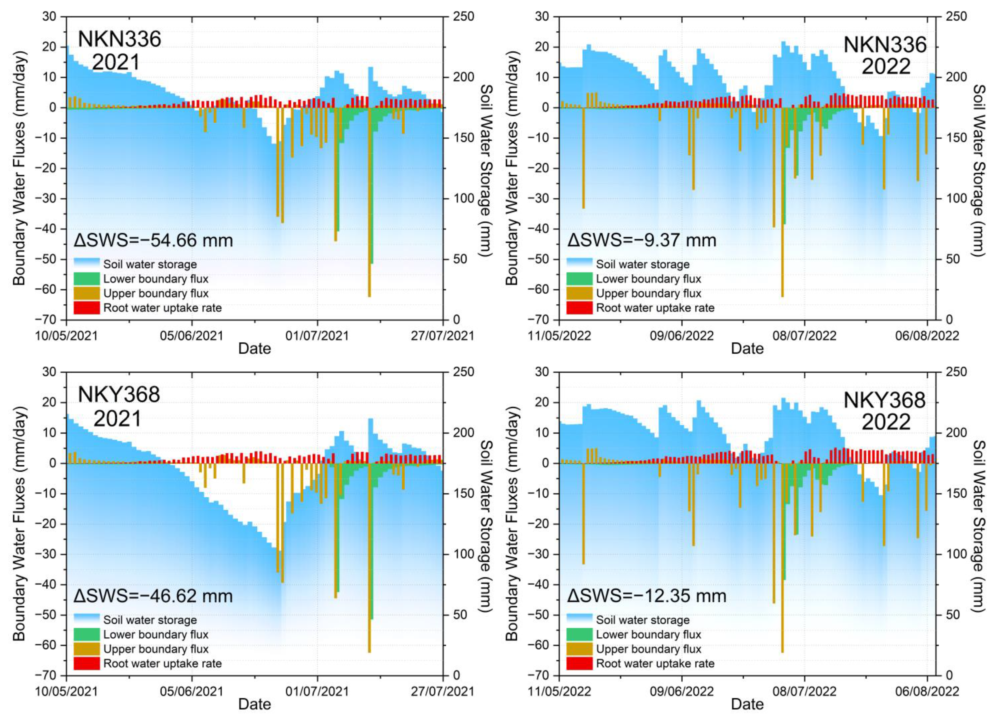
5.1. Water Boundary Flux Characteristics of the Maize Root Zone
5.2. Comparison of Accuracy of Parameter Acquisition Methods for Estimating Overall Root Zone SWC
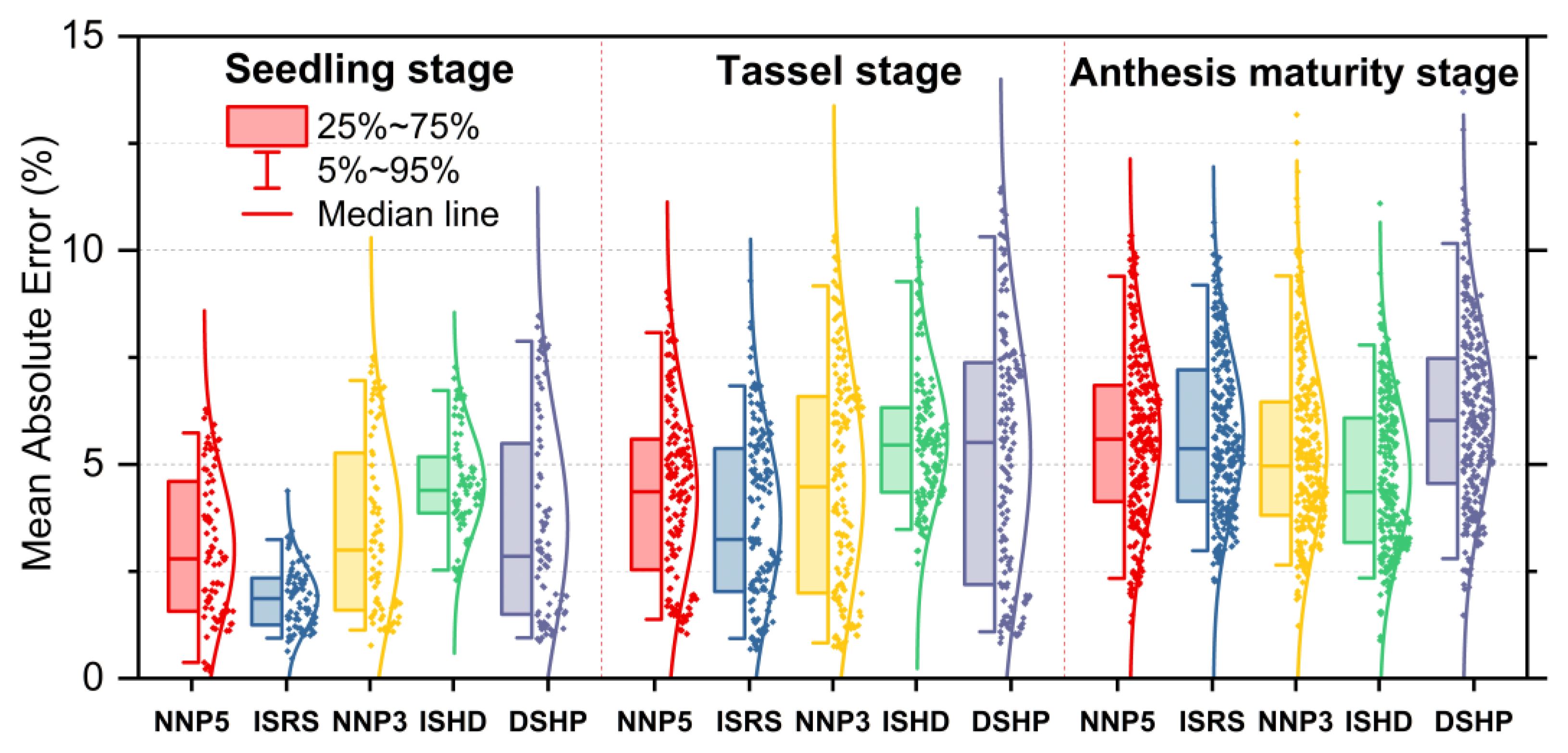
5.3. Accuracy Comparison of Parameter Acquisition Methods for Estimating SWC at Different Maize Growth Stages
5.4. Accuracy Comparison of SWC Estimation at Different Depths for each Parameter Acquisition Method
6. Conclusions
Author Contributions
Funding
Institutional Review Board Statement
Informed Consent Statement
Data Availability Statement
Conflicts of Interest
References
- Tanumihardjo, S.A.; McCulley, L.; Roh, R.; Lopez-Ridaura, S.; Palacios-Rojas, N.; Gunaratna, N.S. Maize Agro-Food Systems to Ensure Food and Nutrition Security in Reference to the Sustainable Development Goals. Glob. Food Secur. 2020, 25, 100327. [Google Scholar] [CrossRef]
- China National Bureau of Statistics Information Disclosure of National Bureau of Statistics. Available online: http://www.stats.gov.cn/xxgk/jd/sjjd2020/202112/t20211206_1825067.html (accessed on 11 June 2022).
- Adeyemi, O.; Grove, I.; Peets, S.; Domun, Y.; Norton, T. Dynamic Neural Network Modelling of Soil Moisture Content for Predictive Irrigation Scheduling. Sensors 2018, 18, 3408. [Google Scholar] [CrossRef] [PubMed]
- Peichl, M.; Thober, S.; Meyer, V.; Samaniego, L. The Effect of Soil Moisture Anomalies on Maize Yield in Germany. Nat. Hazards Earth Syst. Sci. 2018, 18, 889–906. [Google Scholar] [CrossRef]
- Togneri, R.; Felipe dos Santos, D.; Camponogara, G.; Nagano, H.; Custódio, G.; Prati, R.; Fernandes, S.; Kamienski, C. Soil Moisture Forecast for Smart Irrigation: The Primetime for Machine Learning. Expert Syst. Appl. 2022, 207, 117653. [Google Scholar] [CrossRef]
- Li, L.; Li, X.; Zheng, X.; Li, X.; Jiang, T.; Ju, H.; Wan, X. The Effects of Declining Soil Moisture Levels on Suitable Maize Cultivation Areas in Northeast China. J. Hydrol. 2022, 608, 127636. [Google Scholar] [CrossRef]
- Yu, J.; Zhang, X.; Xu, L.; Dong, J.; Zhangzhong, L. A Hybrid CNN-GRU Model for Predicting Soil Moisture in Maize Root Zone. Agric. Water Manag. 2021, 245, 106649. [Google Scholar] [CrossRef]
- Yu, J.; Tang, S.; Zhangzhong, L.; Zheng, W.; Wang, L.; Wong, A.; Xu, L. A Deep Learning Approach for Multi-Depth Soil Water Content Prediction in Summer Maize Growth Period. IEEE Access 2020, 8, 199097–199110. [Google Scholar] [CrossRef]
- Cai, Y.; Zheng, W.; Zhang, X.; Zhangzhong, L.; Xue, X. Research on Soil Moisture Prediction Model Based on Deep Learning. PLoS ONE 2019, 14, e0214508. [Google Scholar] [CrossRef]
- Hateffard, F.; Dolati, P.; Heidari, A.; Zolfaghari, A.A. Assessing the Performance of Decision Tree and Neural Network Models in Mapping Soil Properties. J. Mt. Sci. 2019, 16, 1833–1847. [Google Scholar] [CrossRef]
- Lu, J.; Lu, H. Enhanced Cd Transport in the Soil-Plant-Atmosphere Continuum (SPAC) System by Tobacco (Nicotiana tabacum L.). Chemosphere 2019, 225, 395–405. [Google Scholar] [CrossRef]
- Šimůnek, J.; van Genuchten, M.T.; Šejna, M. Recent Developments and Applications of the HYDRUS Computer Software Packages. Vadose Zone J. 2016, 15, vzj2016.04.003. [Google Scholar] [CrossRef]
- Steduto, P.; Hsiao, T.C.; Raes, D.; Fereres, E. AquaCrop—The FAO Crop Model to Simulate Yield Response to Water: I. Concepts and Underlying Principles. Agron. J. 2009, 101, 426–437. [Google Scholar] [CrossRef]
- Ebrahimi-Mollabashi, E.; Huth, N.I.; Holzwoth, D.P.; Ordóñez, R.A.; Hatfield, J.L.; Huber, I.; Castellano, M.J.; Archontoulis, S.V. Enhancing APSIM to Simulate Excessive Moisture Effects on Root Growth. Field Crops Res. 2019, 236, 58–67. [Google Scholar] [CrossRef]
- Wang, Z.; Ye, L.; Jiang, J.; Fan, Y.; Zhang, X. Review of Application of EPIC Crop Growth Model. Ecol. Model. 2022, 467, 109952. [Google Scholar] [CrossRef]
- Asada, K.; Eguchi, S.; Ikeba, M.; Kato, T.; Yada, S.; Nakajima, Y.; Itahashi, S. Modeling Nitrogen Leaching from Andosols Amended with Different Composted Manures Using LEACHM. Nutr. Cycl. Agroecosyst. 2018, 110, 307–326. [Google Scholar] [CrossRef]
- Aguilera, H.; Moreno, L.; Wesseling, J.G.; Jiménez-Hernández, M.E.; Castaño, S. Soil Moisture Prediction to Support Management in Semiarid Wetlands during Drying Episodes. Catena 2016, 147, 709–724. [Google Scholar] [CrossRef]
- Arshad Awan, Z.; Khaliq, T.; Masood Akhtar, M.; Imran, A.; Irfan, M.; Jarrar Ahmed, M.; Ahmad, A. Building Climate-Resilient Cotton Production System for Changing Climate Scenarios Using the DSSAT Model. Sustainability 2021, 13, 10495. [Google Scholar] [CrossRef]
- Šimunek, J.; van Genuchten, M.T.; Šejna, M. HYDRUS: Model Use, Calibration, and Validation. Trans. ASABE 2012, 55, 1263. [Google Scholar] [CrossRef]
- Tafteh, A.; Sepaskhah, A.R. Application of HYDRUS-1D Model for Simulating Water and Nitrate Leaching from Continuous and Alternate Furrow Irrigated Rapeseed and Maize Fields. Agric. Water Manag. 2012, 113, 19–29. [Google Scholar] [CrossRef]
- Er-Raki, S.; Ezzahar, J.; Merlin, O.; Amazirh, A.; Hssaine, B.A.; Kharrou, M.H.; Khabba, S.; Chehbouni, A. Performance of the HYDRUS-1D Model for Water Balance Components Assessment of Irrigated Winter Wheat under Different Water Managements in Semi-Arid Region of Morocco. Agric. Water Manag. 2021, 244, 106546. [Google Scholar] [CrossRef]
- Ventrella, D.; Castellini, M.; Di Prima, S.; Garofalo, P.; Lassabatère, L. Assessment of the Physically-Based Hydrus-1D Model for Simulating the Water Fluxes of a Mediterranean Cropping System. Water 2019, 11, 1657. [Google Scholar] [CrossRef]
- Tu, A.; Xie, S.; Mo, M.; Song, Y.; Li, Y. Water Budget Components Estimation for a Mature Citrus Orchard of Southern China Based on HYDRUS-1D Model. Agric. Water Manag. 2021, 243, 106426. [Google Scholar] [CrossRef]
- Haj-Amor, Z.; Bouri, S. Use of HYDRUS-1D–GIS Tool for Evaluating Effects of Climate Changes on Soil Salinization and Irrigation Management. Arch. Agron. Soil Sci. 2020, 66, 193–207. [Google Scholar] [CrossRef]
- Lena, B.P.; Bondesan, L.; Pinheiro, E.A.R.; Ortiz, B.V.; Morata, G.T.; Kumar, H. Determination of Irrigation Scheduling Thresholds Based on HYDRUS-1D Simulations of Field Capacity for Multilayered Agronomic Soils in Alabama, USA. Agric. Water Manag. 2022, 259, 107234. [Google Scholar] [CrossRef]
- Wang, X.; Li, Y.; Chen, X.; Wang, H.; Li, L.; Yao, N.; Liu, D.L.; Biswas, A.; Sun, S. Projection of the Climate Change Effects on Soil Water Dynamics of Summer Maize Grown in Water Repellent Soils Using APSIM and HYDRUS-1D Models. Comput. Electron. Agric. 2021, 185, 106142. [Google Scholar] [CrossRef]
- Yinglan, A.; Wang, G.; Hu, P.; Lai, X.; Xue, B.; Fang, Q. Root-Zone Soil Moisture Estimation Based on Remote Sensing Data and Deep Learning. Environ. Res. 2022, 212, 113278. [Google Scholar] [CrossRef]
- Mahmood, A.; Farhadi, L.; Heidary, P. A Framework for Coupled Estimation of Evapotranspiration and Recharge Flux by Assimilating Remotely Sensed Land Surface Temperature and Soil Moisture Observation. In Proceedings of the 2021 IEEE International Geoscience and Remote Sensing Symposium IGARSS, Brussels, Belgium, 11–16 July 2021; pp. 6455–6457. [Google Scholar]
- Laluet, P.; Guerra, L.E.O.; Gaspar, V.A.; Rivalland, V.; Simonneaux, V.; Bustillo, V.; Bellvert, J.; Villar, J.M.; Merlin, O. Estimating the Drainage of Irrigated Areas: A Combined Crop Water Balance Modeling and Remote Sensing Approach. In Proceedings of the Copernicus Meetings, Montpellier, France, 29 May–3 June 2022. [Google Scholar]
- Kocian, L.; Mohanty, B. Evaluating the Presence of Preferential Flow Using Machine Learning Algorithms and Remote Sensing Data. AGU Fall Meet. Abstr. 2021, 2021, H35P-1218. [Google Scholar]
- Carsel, R.F.; Parrish, R.S. Developing Joint Probability Distributions of Soil Water Retention Characteristics. Water Resour. Res. 1988, 24, 755–769. [Google Scholar] [CrossRef]
- Hopmans, J.W.; Bristow, K.L. Current Capabilities and Future Needs of Root Water and Nutrient Uptake Modeling. In Advances in Agronomy; Sparks, D.L., Ed.; Academic Press: Cambridge, MA, USA, 2002; Volume 77, pp. 103–183. [Google Scholar]
- Zhu, W.; Li, H.; Qu, H.; Wang, Y.; Misselbrook, T.; Li, X.; Jiang, R. Water Stress in Maize Production in the Drylands of the Loess Plateau. Vadose Zone J. 2018, 17, 180117. [Google Scholar] [CrossRef]
- Javadi, A.; Shayannejad, M.; Ebrahimian, H.; Ghorbani-Dashtaki, S. Simulation Modeling of Border Irrigation Performance under Different Soil Texture Classes and Land Uses. Model. Earth Syst. Environ. 2022, 8, 1135–1144. [Google Scholar] [CrossRef]
- Shelia, V.; Šimůnek, J.; Boote, K.; Hoogenbooom, G. Coupling DSSAT and HYDRUS-1D for Simulations of Soil Water Dynamics in the Soil-Plant-Atmosphere System. J. Hydrol. Hydromech. 2018, 66, 232–245. [Google Scholar] [CrossRef]
- Colliander, A.; Reichle, R.; Crow, W.; Cosh, M.; Chen, F.; Chan, S.; Das, N.N.; Bindlish, R.; Chaubell, J.; Kim, S.; et al. Validation of Soil Moisture Data Products From the NASA SMAP Mission. IEEE J. Sel. Top. Appl. Earth Obs. Remote Sens. 2022, 15, 364–392. [Google Scholar] [CrossRef]
- Wang, X.; Lü, H.; Crow, W.T.; Zhu, Y.; Wang, Q.; Su, J.; Zheng, J.; Gou, Q. Assessment of SMOS and SMAP Soil Moisture Products against New Estimates Combining Physical Model, a Statistical Model, and in-Situ Observations: A Case Study over the Huai River Basin, China. J. Hydrol. 2021, 598, 126468. [Google Scholar] [CrossRef]
- Colliander, A.; Jackson, T.J.; Bindlish, R.; Chan, S.; Das, N.; Kim, S.B.; Cosh, M.H.; Dunbar, R.S.; Dang, L.; Pashaian, L.; et al. Validation of SMAP Surface Soil Moisture Products with Core Validation Sites. Remote Sens. Environ. 2017, 191, 215–231. [Google Scholar] [CrossRef]
- Nadeem, M.U.; Ghanim, A.A.J.; Anjum, M.N.; Shangguan, D.; Rasool, G.; Irfan, M.; Niazi, U.M.; Hassan, S. Multiscale Ground Validation of Satellite and Reanalysis Precipitation Products over Diverse Climatic and Topographic Conditions. Remote Sens. 2022, 14, 4680. [Google Scholar] [CrossRef]
- Muñoz Sabater, J. ERA5-Land Hourly Data from 1981 to Present. Copernic. Clim. Chang. Serv. C3S Clim. Data Store CDS 2019, 10. [Google Scholar] [CrossRef]
- Gorelick, N.; Hancher, M.; Dixon, M.; Ilyushchenko, S.; Thau, D.; Moore, R. Google Earth Engine: Planetary-Scale Geospatial Analysis for Everyone. Remote Sens. Environ. 2017, 202, 18–27. [Google Scholar] [CrossRef]
- Richards, L.A. Capillary Conduction of Liquids through Porous Mediums. Physics 1931, 1, 318–333. [Google Scholar] [CrossRef]
- van Genuchten, M.T. A Closed-Form Equation for Predicting the Hydraulic Conductivity of Unsaturated Soils. Soil Sci. Soc. Am. J. 1980, 44, 892–898. [Google Scholar] [CrossRef]
- Allen, R.G.; Pereira, L.S.; Raes, D.; Smith, M. Crop Evapotranspiration. Guidelines for Computing Crop Water Requirements. FAO Irrig. Drain. Pap. FAO 1998, 300, D05109. [Google Scholar]
- Belmans, C.; Wesseling, J.G.; Feddes, R.A. Simulation Model of the Water Balance of a Cropped Soil: SWATRE. J. Hydrol. 1983, 63, 271–286. [Google Scholar] [CrossRef]
- Wu, Y.; Huang, M. Analysis of Influential Factors for Maize Root Water Uptake Based on Hydrus-1D Model. Trans. Chin. Soc. Agric. Eng. 2011, 27, 66–73. [Google Scholar]
- Feddes, R.A. Simulation of Field Water Use and Crop Yield. In Simulation of Plant Growth and Crop Production; Pudoc: Wageningen, The Netherlands, 1982; pp. 194–209. [Google Scholar]
- Wesseling, J.G.; Elbers, J.A.; Kabat, P.; Van den Broek, B.J. SWATRE: Instructions for Input; Internal Note; Winand Staring Centre: Wageningen, The Netherlands, 1991. [Google Scholar]
- Schaap, M.G.; Leij, F.J.; van Genuchten, M.T. Rosetta: A Computer Program for Estimating Soil Hydraulic Parameters with Hierarchical Pedotransfer Functions. J. Hydrol. 2001, 251, 163–176. [Google Scholar] [CrossRef]
- Šimůnek, J.; Hopmans, J.W. 1.7 Parameter Optimization and Nonlinear Fitting. In Methods of Soil Analysis; John Wiley & Sons, Ltd.: Hoboken, NJ, USA, 2002; pp. 139–157. ISBN 978-0-89118-893-3. [Google Scholar]
- Chen, S.; Arrouays, D.; Leatitia Mulder, V.; Poggio, L.; Minasny, B.; Roudier, P.; Libohova, Z.; Lagacherie, P.; Shi, Z.; Hannam, J.; et al. Digital Mapping of GlobalSoilMap Soil Properties at a Broad Scale: A Review. Geoderma 2022, 409, 115567. [Google Scholar] [CrossRef]
- Nachtergaele, F.O.; Spaargaren, O.; Deckers, J.A.; Ahrens, B. New Developments in Soil Classification: World Reference Base for Soil Resources. Geoderma 2000, 96, 345–357. [Google Scholar] [CrossRef]
- García-Gaines, R.A.; Frankenstein, S. USCS and the USDA Soil Classification System: Development of a Mapping Scheme; U.S. Army Engineer Research and Development Center, Cold Regions Research and Engineering Laboratory: Hanover, NH, USA, 2015.
- Gao, Y.; Zhang, M.; Wang, Z.; Zhang, Y. Yield Sustainability of Winter Wheat under Three Limited-Irrigation Schemes Based on a 28-Year Field Experiment. Crop J. 2022. [Google Scholar] [CrossRef]
- Ma, X.Y.; Zhou, G.S. Method of Determining the Maximum Leaf Area Index of Spring Maize and Its Application. Acta Ecol. Sin. 2013, 33, 2596–2603. [Google Scholar]
- Wang, X.L. How to Use the Logistic Equation Reasonably in the Simulation of Dry Matter Accumulation of Crops. Chin. J. Agrometeorol. 1986, 8, 14–19. [Google Scholar]
- Myneni, R.; Knyazikhin, Y.; Park, T. MODIS/Terra+Aqua Leaf Area Index/FPAR 4-Day L4 Global 500m SIN Grid V061 [Data Set]; NASA EOSDIS Land Processes DAAC: Sioux Falls, SD, USA, 2015. [Google Scholar]
- Chaoming, D.; Pengnian, W.; Ling, Y.; Yuhua, L.; Xiaokang, G.; Tongchao, W. Modelling the Effect of Tillage on Soil Water Dynamics in Corn Field. Guangai Paishui Xuebao 2020, 39, 24–31. [Google Scholar]
- Noshadi, M.; Fahandej-Saadi, S.; Sepaskhah, A.R. Application of SALTMED and HYDRUS-1D Models for Simulations of Soil Water Content and Soil Salinity in Controlled Groundwater Depth. J. Arid Land 2020, 12, 447–461. [Google Scholar] [CrossRef]
- Muñoz-Sabater, J.; Dutra, E.; Agustí-Panareda, A.; Albergel, C.; Arduini, G.; Balsamo, G.; Boussetta, S.; Choulga, M.; Harrigan, S.; Hersbach, H.; et al. ERA5-Land: A State-of-the-Art Global Reanalysis Dataset for Land Applications. Earth Syst. Sci. Data 2021, 13, 4349–4383. [Google Scholar] [CrossRef]
- Wu, Z.; Feng, H.; He, H.; Zhou, J.; Zhang, Y. Evaluation of Soil Moisture Climatology and Anomaly Components Derived From ERA5-Land and GLDAS-2.1 in China. Water Resour. Manag. 2021, 35, 629–643. [Google Scholar] [CrossRef]
- Pelosi, A.; Chirico, G.B. Regional Assessment of Daily Reference Evapotranspiration: Can Ground Observations Be Replaced by Blending ERA5-Land Meteorological Reanalysis and CM-SAF Satellite-Based Radiation Data? Agric. Water Manag. 2021, 258, 107169. [Google Scholar] [CrossRef]
- Campos-Taberner, M.; Moreno-Martínez, Á.; García-Haro, F.J.; Camps-Valls, G.; Robinson, N.P.; Kattge, J.; Running, S.W. Global Estimation of Biophysical Variables from Google Earth Engine Platform. Remote Sens. 2018, 10, 1167. [Google Scholar] [CrossRef]
- Jebli, I.; Belouadha, F.-Z.; Kabbaj, M.I.; Tilioua, A. Prediction of Solar Energy Guided by Pearson Correlation Using Machine Learning. Energy 2021, 224, 120109. [Google Scholar] [CrossRef]
- Yu, J.; Zheng, W.; Xu, L.; Meng, F.; Li, J.; Zhangzhong, L. TPE-CatBoost: An Adaptive Model for Soil Moisture Spatial Estimation in the Main Maize-Producing Areas of China with Multiple Environment Covariates. J. Hydrol. 2022, 613, 128465. [Google Scholar] [CrossRef]
- Alun, L.; Weizhong, Y.; Juan, L. Spatial Analysis Methods and Application of Regional Soil Moisture. Chin. Agric. Sci. Bull. 2012, 2012, 60. [Google Scholar]
- Klute, A.; Dirksen, C. Hydraulic Conductivity and Diffusivity: Laboratory Methods. In Methods of Soil Analysis; John Wiley & Sons, Ltd.: Hoboken, NJ, USA, 1986; pp. 687–734. ISBN 978-0-89118-864-3. [Google Scholar]
- Kanda, E.K.; Senzanje, A.; Mabhaudhi, T. Coupling Hydrus 2D/3D and AquaCrop Models for Simulation of Water Use in Cowpea (Vigna Unguiculata (L.) Walp). In Proceedings of the Sustaining Tomorrow; Ting, D.S.-K., Vasel-Be-Hagh, A., Eds.; Springer International Publishing: Cham, Switzerland, 2021; pp. 53–63. [Google Scholar]


| Parameters | Value | Definition |
|---|---|---|
| P0 (cm) | –15 | root suction pressure head |
| P0pt (cm) | –30 | root maximum rate suction pressure head |
| P2H (cm) | –325 | ultimate pressure head |
| P2L (cm) | –600 | pressure head when transpiration rate is r2L |
| P3 (cm) | –8000 | withering point pressure head |
| r2H | 0.5 | hourly potential transpiration rate |
| r2L | 0.1 | potential transpiration rate |
| Year | Depth (cm) | Soil Particle Volume Fraction | Soil Field Capacity (cm3/cm3) | Soil Bulk Density (g/cm3) | ||||
|---|---|---|---|---|---|---|---|---|
| Sand | Silt | Clay | ||||||
| 0.25 ≤ Ф < 2 (mm) | 0.05 ≤ Ф < 0.25 (mm) | 0.02 ≤ Ф < 0.05 (mm) | 0.002 ≤ Ф < 0.02 (mm) | Ф < 0.002 (mm) | ||||
| 2021 | 10 cm | 2.30% | 24.82% | 19.72% | 15.80% | 37.36% | 33.39% | 1.49 |
| 20 cm | 2.40% | 26.02% | 16.64% | 21.88% | 33.06% | 33.85% | 1.52 | |
| 30 cm | 2.93% | 25.71% | 21.80% | 19.16% | 30.40% | 33.26% | 1.52 | |
| 40 cm | 2.66% | 23.50% | 21.76% | 20.28% | 31.80% | 33.24% | 1.46 | |
| 50 cm | 4.01% | 28.39% | 16.52% | 18.72% | 32.36% | 33.28% | 1.51 | |
| 60 cm | 3.59% | 23.39% | 19.84% | 19.02% | 34.16% | 35.18% | 1.59 | |
| Mean | 2.96% | 25.31% | 19.38% | 19.14% | 33.21% | 33.70% | 1.52 | |
| 2022 | 10 cm | 3.31% | 25.04% | 20.58% | 15.84% | 35.23% | 33.14% | 1.51 |
| 20 cm | 2.90% | 24.93% | 25.80% | 17.30% | 29.07% | 33.07% | 1.53 | |
| 30 cm | 3.01% | 25.89% | 22.38% | 18.90% | 29.82% | 32.54% | 1.54 | |
| 40 cm | 3.33% | 26.71% | 18.22% | 17.92% | 33.82% | 33.71% | 1.53 | |
| 50 cm | 4.09% | 29.53% | 18.24% | 17.30% | 30.84% | 32.47% | 1.54 | |
| 60 cm | 4.10% | 26.88% | 19.14% | 17.38% | 32.50% | 33.36% | 1.56 | |
| Mean | 3.45% | 26.50% | 20.73% | 17.44% | 31.88% | 33.05% | 1.54 | |
| Year | Variety | Equation Parameters | R2 | |||
|---|---|---|---|---|---|---|
| 2021 | NKY368 | 16.8894 | 8.9255 | –0.2303 | 0.0016 | 0.9802 * |
| NKN336 | 11.0794 | 9.2782 | –0.2605 | 0.0019 | 0.9907 * | |
| JKT608 | 4.6855 | 10.2934 | –0.3352 | 0.0024 | 0.9968 * | |
| 2022 | NKY368 | 8.9247 | 9.8351 | –0.2935 | 0.002 | 0.9979 * |
| NKN336 | 5.5897 | 9.9825 | –0.3189 | 0.0022 | 0.9997 * | |
| JKT608 | 4.3050 | 11.7665 | –0.3913 | 0.0026 | 0.9996 * | |
| Year | Seedling Stage | Tassel Stage | Anthesis Maturity Stage | Total Days |
|---|---|---|---|---|
| 2021 | 04/15–5/18 | 05/19–6/13 | 06/14–7/27 | 103 |
| 2022 | 05/01–5/29 | 05/30–6/24 | 06/25–8/8 | 99 |
| Source | Name | Units | Resolution | Scale Factor | Description |
|---|---|---|---|---|---|
| dewpoint_temperature_2 m | K | 0.1° × 0.1° | 1 | 2 m dew point temperature | |
| ERA5-Land | temperature_2 m | K | 0.1° × 0.1° | 1 | Temperature of air at 2 m above land surface |
| u_component_of_wind_10 m | m/s | 0.1° × 0.1° | 1 | Eastward component of the 10 m wind | |
| v_component_of_wind_10 m | m/s | 0.1° × 0.1° | 1 | Northward component of the 10 m wind | |
| surface_pressure | Pa | 0.1° × 0.1° | 1 | Pressure of the atmosphere on the surface | |
| total_precipitation | m | 0.1° × 0.1° | 1 | Large-scale precipitation and convective precipitation | |
| surface_net_solar_radiation | J/m2 | 0.1° × 0.1° | 1 | Amount of solar radiation reaching the surface minus the amount reflected | |
| volumetric_soil_water_layer_1 (SVWC1) | m3/m3 | 0.1° × 0.1° | 1 | Volume of water in soil layer 1 (0–7 cm) | |
| volumetric_soil_water_layer_2 (SVWC2) | m3/m3 | 0.1° × 0.1° | 1 | Volume of water in soil layer 2 (7–28 cm) | |
| volumetric_soil_water_layer_3 (SVWC3) | m3/m3 | 0.1° × 0.1° | 1 | Volume of water in soil layer 3 (28–100 cm) | |
| MCD15A3H | Lai_500m | m2/m2 | 500 m | 0.1 | 4-day composite data set with 500-m pixel size |
| Method | Year | Depth (cm) | ||||||
|---|---|---|---|---|---|---|---|---|
| DSHP | 1988 | 10–60 cm | 0.0950 | 0.4100 | 0.0190 | 1.31 | 6.24 | 0.50 |
| NNP3 | 2021 | 10 cm | 0.0869 | 0.4517 | 0.0130 | 1.37 | 8.57 | 0.50 |
| 20 cm | 0.0831 | 0.4444 | 0.0112 | 1.42 | 9.96 | 0.50 | ||
| 30 cm | 0.0804 | 0.4402 | 0.0099 | 1.46 | 11.36 | 0.50 | ||
| 40 cm | 0.0828 | 0.4468 | 0.0098 | 1.45 | 11.78 | 0.50 | ||
| 50 cm | 0.0810 | 0.4360 | 0.0126 | 1.41 | 7.19 | 0.50 | ||
| 60 cm | 0.0846 | 0.4487 | 0.0113 | 1.42 | 10.47 | 0.50 | ||
| Average | 0.0831 | 0.4446 | 0.0113 | 1.42 | 9.89 | 0.50 | ||
| NNP3 | 2022 | 10 cm | 0.0849 | 0.4471 | 0.0124 | 1.40 | 8.60 | 0.50 |
| 20 cm | 0.0792 | 0.4391 | 0.0090 | 1.48 | 12.10 | 0.50 | ||
| 30 cm | 0.0797 | 0.4388 | 0.0097 | 1.47 | 11.50 | 0.50 | ||
| 40 cm | 0.0831 | 0.4422 | 0.0123 | 1.41 | 8.04 | 0.50 | ||
| 50 cm | 0.0792 | 0.4320 | 0.0124 | 1.42 | 7.10 | 0.50 | ||
| 60 cm | 0.0816 | 0.4389 | 0.0120 | 1.42 | 8.06 | 0.50 | ||
| Average | 0.0812 | 0.4396 | 0.0113 | 1.43 | 9.23 | 0.50 | ||
| NNP5 | 2021 | 10 cm | 0.0795 | 0.4207 | 0.0123 | 1.31 | 6.76 | 0.50 |
| 20 cm | 0.0767 | 0.4112 | 0.0090 | 1.36 | 4.70 | 0.50 | ||
| 30 cm | 0.0742 | 0.4074 | 0.0080 | 1.40 | 5.04 | 0.50 | ||
| 40 cm | 0.0766 | 0.4228 | 0.0087 | 1.40 | 7.45 | 0.50 | ||
| 50 cm | 0.0750 | 0.4119 | 0.0098 | 1.35 | 5.36 | 0.50 | ||
| 60 cm | 0.0779 | 0.3991 | 0.0081 | 1.35 | 2.37 | 0.50 | ||
| Average | 0.0766 | 0.4121 | 0.0093 | 1.36 | 5.28 | 0.50 | ||
| NNP5 | 2022 | 10 cm | 0.0772 | 0.4134 | 0.0113 | 1.33 | 5.73 | 0.50 |
| 20 cm | 0.0728 | 0.4033 | 0.0074 | 1.42 | 4.99 | 0.50 | ||
| 30 cm | 0.0720 | 0.4001 | 0.0086 | 1.39 | 4.83 | 0.50 | ||
| 40 cm | 0.0763 | 0.4090 | 0.0099 | 1.34 | 4.51 | 0.50 | ||
| 50 cm | 0.0719 | 0.4011 | 0.0101 | 1.35 | 4.79 | 0.50 | ||
| 60 cm | 0.0741 | 0.3996 | 0.0096 | 1.34 | 3.76 | 0.50 | ||
| Average | 0.0741 | 0.4044 | 0.0095 | 1.36 | 4.76 | 0.50 | ||
| ISHD | 2021 | 10 cm | 0.0968 | 0.3437 | 0.0190 | 1.31 | 5.47 | 0.25 |
| 20 cm | 0.0516 | 0.3921 | 0.0127 | 1.73 | 8.46 | 0.26 | ||
| 30 cm | 0.0710 | 0.3850 | 0.0149 | 1.40 | 5.42 | 0.38 | ||
| 40 cm | 0.0496 | 0.3780 | 0.0151 | 1.32 | 7.96 | 0.27 | ||
| 50 cm | 0.0873 | 0.3729 | 0.0141 | 1.34 | 8.93 | 0.40 | ||
| 60 cm | 0.1193 | 0.3621 | 0.0113 | 1.32 | 4.99 | 0.44 | ||
| Average | 0.0793 | 0.3723 | 0.0145 | 1.40 | 6.87 | 0.33 | ||
| ISRS | 2019 | 10–60 cm | 0.0838 | 0.4503 | 0.0049 | 1.44 | 9.80 | 0.65 |
| 2018 | 10–60 cm | 0.0853 | 0.4391 | 0.0069 | 1.40 | 11.38 | 0.76 | |
| 2017 | 10–60 cm | 0.0842 | 0.4535 | 0.0074 | 1.45 | 8.68 | 0.64 | |
| 2016 | 10–60 cm | 0.0870 | 0.4381 | 0.0049 | 1.44 | 11.73 | 0.91 | |
| 2015 | 10–60 cm | 0.0834 | 0.4425 | 0.0087 | 1.42 | 10.75 | 0.65 | |
| Average | 10–60 cm | 0.0847 | 0.4447 | 0.0065 | 1.39 | 10.47 | 0.72 |
| Indicator | Unit | 2021 | 2022 | ||||||||
|---|---|---|---|---|---|---|---|---|---|---|---|
| Mean | SD | Min | Median | Max | Mean | SD | Min | Median | Max | ||
| SVWC10 | % | 25.66 | 6.73 | 8.02 | 26.06 | 38.50 | 24.71 | 4.56 | 13.07 | 25.28 | 33.07 |
| SVWC20 | % | 27.92 | 5.74 | 13.90 | 28.76 | 38.43 | 31.12 | 5.19 | 15.91 | 32.73 | 39.95 |
| SVWC30 | % | 27.24 | 4.55 | 14.93 | 28.03 | 36.46 | 33.26 | 3.77 | 20.98 | 34.62 | 38.29 |
| SVWC40 | % | 28.02 | 4.55 | 16.33 | 29.52 | 35.50 | 34.17 | 2.48 | 26.45 | 34.35 | 38.35 |
| SVWC50 | % | 28.24 | 4.01 | 17.90 | 28.37 | 35.49 | 33.39 | 1.78 | 29.00 | 33.79 | 36.83 |
| SVWC60 | % | 28.16 | 3.73 | 19.40 | 28.60 | 36.18 | 32.21 | 1.65 | 27.91 | 32.47 | 35.78 |
| T | °C | 25.21 | 3.12 | 16.08 | 25.62 | 30.56 | 25.71 | 3.43 | 15.80 | 26.67 | 31.25 |
| RH | % | 60.08 | 20.01 | 18.49 | 62.25 | 94.61 | 69.28 | 17.26 | 27.43 | 75.15 | 98.95 |
| Pr | mm | 4.48 | 11.66 | 0 | 0 | 73.80 | 4.93 | 12.53 | 0 | 0 | 87.60 |
| U2 | m/s | 2.37 | 0.80 | 0.89 | 2.26 | 4.80 | 2.33 | 0.71 | 1.21 | 2.17 | 4.99 |
| Rn | MJ/m2 | 12.66 | 3.71 | 2.68 | 13.03 | 17.87 | 13.37 | 3.54 | 3.58 | 14.45 | 17.55 |
| P | hPa | 1003.29 | 4.28 | 988.95 | 1002.39 | 1010.76 | 1005.30 | 4.37 | 994.95 | 1005 | 1017.38 |
| ETp | mm | 4.56 | 1.10 | 2.40 | 4.30 | 7.30 | 4.84 | 0.91 | 1.80 | 4.80 | 7.30 |
| Indicator | Unit | Mean | SD | Min | Median | Max |
| SVWC1 | % | 23.72 | 9.08 | 12.12 | 21.42 | 42.51 |
| SVWC2 | % | 22.05 | 8.48 | 13.40 | 18.65 | 41.67 |
| SVWC3 | % | 18.45 | 3.93 | 14.30 | 17.10 | 30.52 |
| Tdew | °C | 15.45 | 7.36 | –10.80 | 16.42 | 26.98 |
| Tmean | °C | 26.25 | 3.46 | 10.37 | 26.52 | 34.51 |
| Rn | MJ/m2 | 13.10 | 3.92 | 1.22 | 14.41 | 17.75 |
| U2 | m/s | 2.38 | 0.81 | 0.63 | 2.26 | 5.12 |
| Pr | mm | 6.70 | 13.73 | 0 | 1.00 | 122.00 |
| RH | hPa | 1003.94 | 4.25 | 992.97 | 1003.82 | 1018.14 |
| LAI | m2/m2 | 1.25 | 0.41 | 0.30 | 1.20 | 2.30 |
| Method | Year | Variety | MSE (%) | MAE (%) | RMSE (%) |
|---|---|---|---|---|---|
| NNP5 | 2021 | NKN336 | 28.04 | 4.24 | 5.27 |
| NKY368 | 26.27 | 3.84 | 4.99 | ||
| JKT608 | 33.28 | 4.73 | 5.42 | ||
| 2022 | NKN336 | 33.19 | 4.95 | 5.60 | |
| NKY368 | 41.04 | 5.47 | 6.25 | ||
| JKT608 | 29.89 | 4.48 | 5.31 | ||
| Average | 31.95 | 4.62 | 5.47 | ||
| ISRS | 2021 | NKN336 | 27.51 | 4.16 | 5.22 |
| NKY368 | 27.38 | 3.93 | 5.11 | ||
| JKT608 | 25.68 | 3.97 | 4.79 | ||
| 2022 | NKN336 | 41.31 | 4.97 | 6.03 | |
| NKY368 | 51.78 | 5.55 | 6.76 | ||
| JKT608 | 29.13 | 4.07 | 4.95 | ||
| Average | 33.80 | 4.44 | 5.48 | ||
| NNP3 | 2021 | NKN336 | 28.52 | 4.10 | 5.31 |
| NKY368 | 32.29 | 4.28 | 5.54 | ||
| JKT608 | 30.49 | 4.34 | 5.20 | ||
| 2022 | NKN336 | 35.89 | 5.08 | 5.88 | |
| NKY368 | 44.49 | 5.18 | 6.06 | ||
| JKT608 | 36.52 | 5.04 | 5.94 | ||
| Average | 34.70 | 4.67 | 5.66 | ||
| ISHD | 2021 | NKN336 | 41.60 | 5.27 | 6.31 |
| NKY368 | 28.48 | 4.43 | 5.14 | ||
| JKT608 | Data were used for inverse solution of the parameters. | ||||
| 2022 | NKN336 | 37.59 | 5.01 | 5.77 | |
| NKY368 | 35.55 | 4.86 | 5.66 | ||
| JKT608 | 40.13 | 4.83 | 5.53 | ||
| Average | 36.67 | 4.88 | 5.68 | ||
| DSHP | 2021 | NKN336 | 41.73 | 5.09 | 6.38 |
| NKY368 | 55.42 | 5.59 | 7.33 | ||
| JKT608 | 43.16 | 5.19 | 6.11 | ||
| 2022 | NKN336 | 40.28 | 5.38 | 6.27 | |
| NKY368 | 49.57 | 5.89 | 6.94 | ||
| JKT608 | 41.97 | 5.39 | 6.39 | ||
| Average | 45.36 | 5.42 | 6.57 | ||
| Depth | Method | MAE (%) | ||||||
|---|---|---|---|---|---|---|---|---|
| 2021 | 2022 | Average | ||||||
| NKN336 | NKY368 | JKT608 | NKN336 | NKY368 | JKT608 | |||
| 10 cm | NNP5 | 4.13 | 5.3 | 8.72 | 6.41 | 6.89 | 5.68 | 6.19 |
| ISRS | 4.59 | 3.91 | 7.12 | 9.08 | 10.21 | 7.91 | 7.14 | |
| NNP3 | 4.18 | 4.29 | 7.52 | 6.29 | 4.29 | 5.36 | 5.32 | |
| ISHD | 5.79 | 2.55 | -- | 8.84 | 7.7 | 9.88 | 6.95 | |
| DSHP | 3.78 | 7.12 | 9.86 | 6.31 | 6.62 | 5.60 | 6.55 | |
| 20 cm | NNP5 | 4.75 | 2.41 | 4.13 | 5.74 | 6.13 | 5.60 | 4.79 |
| ISRS | 4.28 | 2.11 | 3.46 | 5.64 | 6.73 | 3.03 | 4.21 | |
| NNP3 | 4.35 | 2.37 | 3.41 | 5.82 | 6.11 | 6.08 | 4.69 | |
| ISHD | 6.05 | 6.32 | -- | 5.38 | 5.12 | 5.18 | 5.61 | |
| DSHP | 5.93 | 4.79 | 4.48 | 6.26 | 6.43 | 6.61 | 5.75 | |
| 30 cm | NNP5 | 4.65 | 3.69 | 3.74 | 4.99 | 5.93 | 4.99 | 4.67 |
| ISRS | 4.49 | 4.04 | 3.21 | 3.95 | 4.47 | 2.24 | 3.73 | |
| NNP3 | 4.64 | 4.26 | 3.37 | 5.19 | 6.15 | 5.83 | 4.91 | |
| ISHD | 2.85 | 6.18 | -- | 5.12 | 5.21 | 6.64 | 5.20 | |
| DSHP | 5.79 | 6.07 | 4.49 | 5.49 | 6.45 | 5.98 | 5.71 | |
| 40 cm | NNP5 | 4.04 | 5.28 | 4.49 | 4.67 | 5.59 | 4.25 | 4.72 |
| ISRS | 3.84 | 5.44 | 3.39 | 3.02 | 3.97 | 2.67 | 3.72 | |
| NNP3 | 3.89 | 6.41 | 4.27 | 4.73 | 5.75 | 4.75 | 4.97 | |
| ISHD | 7.86 | 3.84 | -- | 4.59 | 4.66 | 3.05 | 4.80 | |
| DSHP | 4.99 | 6.77 | 4.53 | 4.99 | 6.29 | 5.27 | 5.47 | |
| 50 cm | NNP5 | 4.66 | 3.53 | 3.26 | 4.66 | 4.61 | 3.52 | 4.04 |
| ISRS | 4.35 | 4.33 | 2.66 | 3.75 | 3.68 | 3.51 | 3.71 | |
| NNP3 | 4.36 | 4.17 | 2.51 | 4.81 | 4.73 | 4.58 | 4.19 | |
| ISHD | 4.69 | 3.98 | -- | 3.86 | 4.11 | 2.94 | 3.92 | |
| DSHP | 5.45 | 4.79 | 3.48 | 5.14 | 5.09 | 4.48 | 4.74 | |
| 60 cm | NNP5 | 3.20 | 2.85 | 4.01 | 3.23 | 3.66 | 2.86 | 3.30 |
| ISRS | 3.39 | 3.76 | 3.98 | 4.38 | 4.26 | 5.06 | 4.14 | |
| NNP3 | 3.20 | 4.19 | 4.95 | 3.61 | 4.02 | 3.66 | 3.94 | |
| ISHD | 4.37 | 3.71 | -- | 2.26 | 2.34 | 1.31 | 2.80 | |
| DSHP | 4.61 | 4.01 | 4.35 | 4.07 | 4.45 | 4.35 | 4.31 | |
Publisher’s Note: MDPI stays neutral with regard to jurisdictional claims in published maps and institutional affiliations. |
© 2022 by the authors. Licensee MDPI, Basel, Switzerland. This article is an open access article distributed under the terms and conditions of the Creative Commons Attribution (CC BY) license (https://creativecommons.org/licenses/by/4.0/).
Share and Cite
Yu, J.; Wu, Y.; Xu, L.; Peng, J.; Chen, G.; Shen, X.; Lan, R.; Zhao, C.; Zhangzhong, L. Evaluating the Hydrus-1D Model Optimized by Remote Sensing Data for Soil Moisture Simulations in the Maize Root Zone. Remote Sens. 2022, 14, 6079. https://doi.org/10.3390/rs14236079
Yu J, Wu Y, Xu L, Peng J, Chen G, Shen X, Lan R, Zhao C, Zhangzhong L. Evaluating the Hydrus-1D Model Optimized by Remote Sensing Data for Soil Moisture Simulations in the Maize Root Zone. Remote Sensing. 2022; 14(23):6079. https://doi.org/10.3390/rs14236079
Chicago/Turabian StyleYu, Jingxin, Yong Wu, Linlin Xu, Junhuan Peng, Guangfeng Chen, Xin Shen, Renping Lan, Chunjiang Zhao, and Lili Zhangzhong. 2022. "Evaluating the Hydrus-1D Model Optimized by Remote Sensing Data for Soil Moisture Simulations in the Maize Root Zone" Remote Sensing 14, no. 23: 6079. https://doi.org/10.3390/rs14236079
APA StyleYu, J., Wu, Y., Xu, L., Peng, J., Chen, G., Shen, X., Lan, R., Zhao, C., & Zhangzhong, L. (2022). Evaluating the Hydrus-1D Model Optimized by Remote Sensing Data for Soil Moisture Simulations in the Maize Root Zone. Remote Sensing, 14(23), 6079. https://doi.org/10.3390/rs14236079