


Abstract
Earthquakes–induced landslides generally provide abundant loose materials at hillslopes, possibly triggering morphological reshaping processes at river channels and riverbeds during the large flash flood hydrograph and bringing huge risk downstream. Therefore, in a Wenchuan earthquake-affected catchment, the collected hydro-meteorological data and high-precision small Unmanned Aerial Vehicle (sUAV) data were used to quantitatively analyze channel evolution by a large flash flood event on 25 and 26 June 2018. It was found that the stable riverbed structure formed by the armour layer appeared in the tenth year after the Wenchuan earthquake. In a confined channel, the layer can protect the channel and resist the drastic change after the flash flood event with only a small bed elevation from 0.2 m to 2 m. Without the protection of the armour, the change could reach 6 m in the unconfined channel. Meanwhile, more materials with a deposition volume of about 7450 m3 from tributaries were generally taken to the main channel, and more intense erosion with a volume of 105 m3 mostly occurred downstream of tributaries. It was noted that, in the cross-section, the increased channel width could lead to a significant change with the large volume of 35 m3. Additionally, a conceptual diagram of the generalized channel response to large flash floods was provided during multi-stage periods after the Wenchuan earthquake. It determined the rebalance processes of channel evolution in the tenth year after the earthquake. This study will contribute to understanding the post-earthquake long-term channel evolutions and could provide decision-makers of assessing the mitigation strategies for higher-magnitude flood disasters triggered by channel change in earthquake-affected watersheds.
1. Introduction
Earthquakes often generate landslides with an uplift of the surface and increase the loose debris on the watershed slopes [1,2]. Earthquake-triggered landslides remain confined to hillslopes at first, and subsequent downslope sediment transport occurs from hillslopes into the channel network during storm-triggered landslides, debris flows, and flash floods as episodic sediment pulses [3]. Over decadal periods, the loose materials migrate from the hillslope towards the channel [4], thus inducing significant river topographic disturbance and rapidly changing riverbed material textures [5]. The change of channel might increase the flood runoff volume and peak discharge and decrease the time to peak discharge leading to a huge risk downstream [6]. After concentrated debris flows following an earthquake, the mass transport triggered by subsequent flash floods will be the most common event in the earthquake-affected area and can repeatedly interrupt the channel’s gradual recovery [7,8].
Flash floods are one of the most dangerous natural hazards in mountainous regions, which are generally triggered by extreme precipitation, or by a sudden release of water due to a dam break [9,10]. Extreme rainfall events are the common cause of flash floods worldwide. Numerous studies have documented that extreme floods induce geomorphological channel changes and fluvial landscape development [11,12], such as widening the channel [13,14] and changes in channel patterns due to erosion and deposition [15,16]. A range of methods has been used to analyze the geomorphic responses to large floods, including the reconstruction of the hydrological event [17], analysis of hydraulic flood variables [14,18], mapping of loose deposits [19], transportation of deposits [20] and quantification of channel changes using field or remotely-sensed data [21,22,23,24]. Based on the previous research [21], high-quality and quantitative morphological change indicators that relate to and integrate various data sources and methods could provide a deep analysis of the hydrodynamic condition of channel changes. The development of small Unmanned Aerial Vehicles (sUAV) provides an opportunity for quantifying geomorphic response to flash floods and provides more detailed and rapid data to be retrieved on morphological responses in the channel [21].
Previous studies suggested that channels with different geometries respond differently to hydrodynamic conditions [25,26]. According to the classification system given by Montgomery and Buffington [27], different scales reflect differences in processes and controls on channel morphology: geomorphic province, watershed, valley segment, channel reach, and channel unit scales. Specifically, the geomorphic province helps distinguish watersheds subject to similar hydrologic, erosional, and tectonic processes [27]. And the watershed level and segment scale were used to classify hillslope, colluvial and alluvial valleys by the relationship between drainage area and slope [28,29]. Furthermore, the system’s behavior at the valley segment level could provide insight into the spatial linkages, including the coupling stages and sediment transportation between different segments, which govern watershed response to disturbance and the capacity of sediment supply and transport [30,31,32,33]. Significant research has focused on the classification of the valley at the watershed scale. However, few studies have quantitatively considered the different geomorphic changes that might occur in different valley segments within the same watershed.
This study utilized sUAV and ground surveys to analyze the channel evolution due to a large flash flood that occurred on 25 and 26 June 2018. The sUAV survey aimed to identify the impact of flash floods on the catchment-wide transportation of co-seismic material and subsequent channel evolution since the 2008 Ms8.0 Wenchuan Earthquake. The objectives of this paper include: (1) quantify the channel evolution by the large flash flood within an earthquake-affected catchment; (2) evaluate the influence of post-earthquake coarsening layer, channel width, and tributaries on channel changes after a flash flood; (3) understand the post-earthquake long-term channel evolution triggered by large flash floods in an earthquake-affected watershed.
2. Materials and Methods
The Longxi River was selected as a typical watershed to quantify the impact of flash floods on channel evolution within a strong earthquake-affected area. Several materials were collected, and methods were applied to summarize the differences within channel evolution with varied channel morphology.
2.1. Study Site
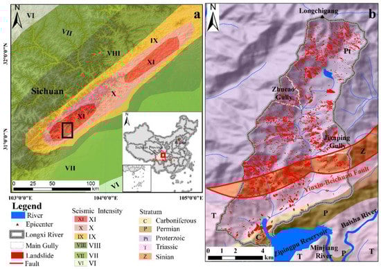
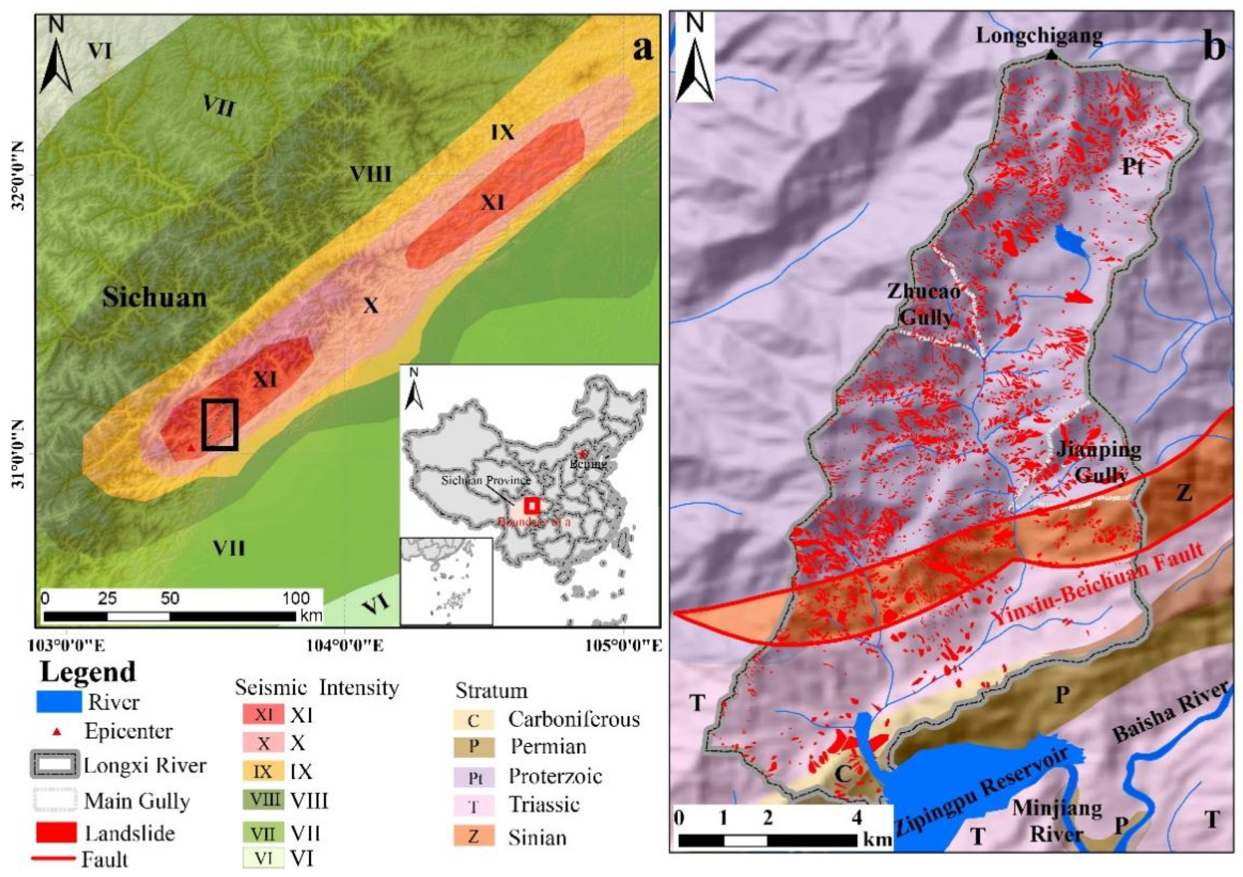
The Longxi River is a tributary of the Minjiang River, located in Chengdu, Sichuan Province, China (31°N, 103°E). The mountainous location is 10 km from the epicenter of the 2008 Ms8.0 Wenchuan Earthquake and within a zone termed ‘the XI intensity area’ [34] (Figure 1a), wherein the Wenchuan Earthquake caused destabilized slopes and vegetation damage over an area of 19.3 km2. The watershed of Longxi has an area of 78.3 km2 with a channel length of 18.2 km from the divide at Longchigang to the Zipingpu reservoir (Figure 1a). The elevation of the catchment ranges from 3284 m to 877 m. The average slope above the mainstream is around 0.68 (34.31°), while the mean mainstream channel gradient is 0.13 (7.4°). According to the field observations, most of the landslides with damaged vegetation were distributed along both sides of the river (Figure 1b), which will provide the loose materials to the generation of the debris flow.
Figure 1.
Location of the Longxi River: (a) Mapped zones of seismic intensity along the Longxi River as affected by the Wenchuan Earthquake. The black square represents the area represented within panel. (b) Generalized lithology, faults and the distribution of co-seismic landslides within the main study area.
The Yingxiu-Beichuan Fault crosses the watershed and is one of the seismogenic faults active during the 2008 Wenchuan Earthquake (Figure 1b). The Yingxiu-Beichuan Fault is a deep fracture trending in the northeast direction, inclined northwest with a dip angle of 50–60° [35]. The upper basin consists mainly of exposed Proterozoic strata composed of granite. Sinian and Triassic strata are exposed downstream, and a small area of Carboniferous and Permian strata is exposed near the reach outlet. And the coverage of vegetation in Longxi River was about 45.39 km2 after the earthquake [6,17].
This region has a subtropical monsoon climate with an average annual rainfall of approximately 1135 mm [17]. Due to the influence of topographic fluctuation and the Zipingpu reservoir, the spatiotemporal difference in rainfall in this area is evident. Moreover, the average flow discharge in the watershed is 3.44 m3/s, with a maximum flow discharge of 300 m3/s and a minimum flow discharge of 0.2 m3/s [36]. Earthquake-induced vegetation loss and the high flow discharge lead to high sediment transportation rates, resulting in significant riverbed geomorphological changes.
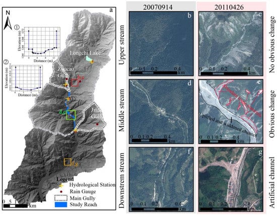
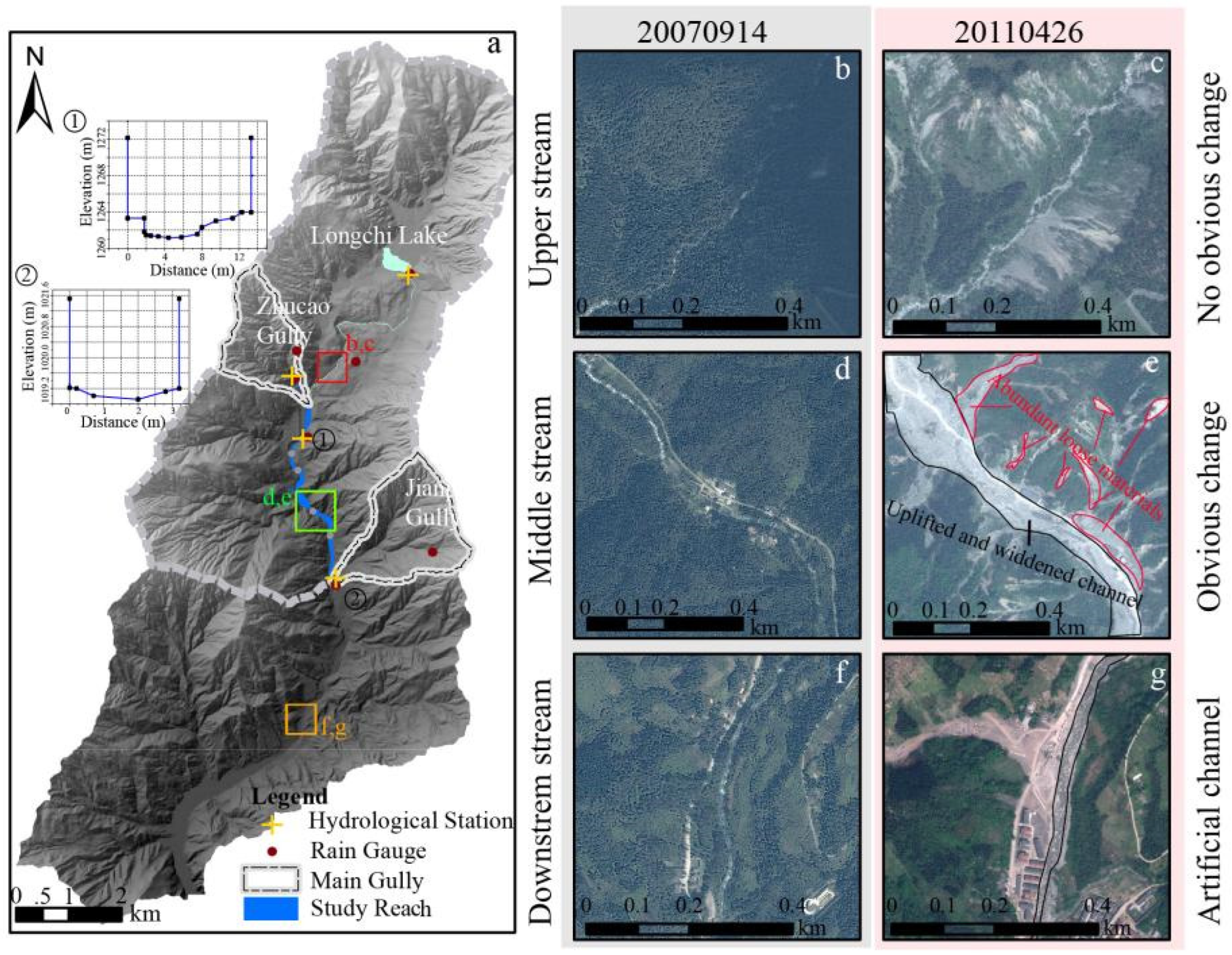
From 2008 to 2020, several catastrophic flash floods and debris flows delivered abundant material to this reach and raised the riverbed. For example, the debris flow, which occurred on 13 August 2010, carried about 7.78 × 10⁶ m3 debris material to the channel [37]. Comparing the images from 14 September 2007 and 26 April 2011, there was little change in the upper stream (Figure 2a,b), the change in the middle change was most apparent (Figure 2c,d), and the change of lower stream was influenced by humans with artificial channel and reservoir (Figure 2e,f). Based on this preliminary assessment, in this study, the main channel in the Longxi River from the outlet of Zhucao Gully to the mouth of Jianping Gully was selected to analyze the post-earthquake evolution of the channel (Figure 2c,d,f), as both gullies provided slope-derived material for transportation leading to significant geomorphic change after the flash flood (Figure 2c,d).
Figure 2.
Boundary and characteristics of the study region: (a) shows the location of the study reach and the monitoring system in the study reach, including rain gauge and flow gauge. (b–g) are local remote sensing images before and after the debris flow occurred on 13 August 2010, which show the change in the channel in different periods. (b,c) showed a minor change in the upper stream, (d,e) showed the apparent change and abundant loose materials in the middle stream and (f,g) showed artificial channels in the downstream influenced by a human.
2.2. Classification of Channel Based on the Hydrodynamic Analysis
The channel changes in the Longxi River are controlled by the movement of the bedload, which is related to the shear stress of the channel flows. The effective shear stress may be expressed as the ratio of the shear stress and the critical Shields shear stress c for particle motion [38,39] (Table A1).
where and are the specific gravity for water and solid material, respectively. In Longxi River, is set to 1.0, and the is set to 2.7 as the lithology is mainly composed of granite. H is the hydraulic radius which is calculated by the ratio of the cross-sectional area to the wetted perimeter and replaced by depth in the study area. S is the stream gradient. v is the mean velocity in the cross-section. n is the manning roughness coefficient, which is substituted by D90 in this study. And D90 is the grain size such that 90% is finer. Q represents the discharge from the upstream, which is usually regarded as a power function of the upstream drainage area (A) [40,41]. W is the width of the channel, and Dc is the critical size of the movement. is the dimensionless shear stress, and the critical for moving the bedload is selected as 0.047 [39].
Based on Equations (1)–(4), the main factors affecting the movement of bed load include the cross-section of the channel (W), the profile of the channel (upstream area A and gradient S), and the typical grain size of the channel (D) (Equation (5)) (Table A1).
Based on previous methods of classifying the channel [27,42,43], the classification considering the characteristics of the transverse section and longitudinal profile is developed and used in this paper. And it helps understand the different responses of the channel reaches to flash floods. Because the channel’s hydrodynamic condition is mainly related to the channel’s morphology, the variation in the hydrodynamic conditions for different locations in the study reach is a focus of the study. The classification of the channel relates to the morphology without considering the particle size.
With respect to the cross-section, the degree of valley confinement is used to describe the extent to which bounding topographic features limit the lateral extent of the valley floor and the floodplain along the river. Thus an index of valley confinement, which is the ratio between the width of the valley and floodplain, might reflect the capacity for channel adjustment, whether vertically, laterally, or wholesale; i.e., it is a measure of freedom to adjust and sensitivity [44]. In this paper, a Valley Confinement Algorithm (VCA) based on the Digital Elevation Model released by David, et al. [30] was used to assess the degree of valley confinement. The definition of the valley floor is based on cost-weighted distance, and the width of the floodplain is based on the flood height and ground slope.
Concerning the longitudinal profile, several researchers have divided the sediment cascade into hillslope, channeled valley, debris-flow-dominated channels, and alluvial channels using relationships between drainage area (A) and slope (S) [28,29,45]. According to the classification system given by Montgomery and Buffington [27], analysis at the valley segment level can distinguish valley morphologies based on the dominant sediment transport process and general sediment flux characteristics. The steepness index (ksn) was selected to divide the channel into reaches to progress analysis at the valley segment level. The values of ksn were determined using a detachment-limited incision model that scales with the relationship between the upstream drainage area and the gradient [46,47,48,49] (Equation (6)). The detachment-limited incision model is predicated on the fact that the river incision rate is proportional as a power function of the mean bed shear stress [47] for steady-state conditions [46,47,49]. This study used the steepness index code calculation method developed by [50,51] (https://topotoolbox.wordpress.com/ (accessed on 29 November 2022)):
where is referred to as the concavity index and represents the rate of change of channel gradient with increasing drainage area (Table A1).
2.3. High-Resolution DSM Acquiring and Processing
Topographic surveys by sUAV were conducted across the study region of the river through Longxi River on 1 April and 4 June 2018 for quantitative analysis of a flash flood that occurred on 25 and 26 June 2018. A sUAV (DJI quadcopter) was used to obtain multiple aerial photographs of each study reach at 5 s intervals to ensure sufficient spatial coverage and a minimum 80% image overlap [52,53,54]. Flights were at a low uniform height (~125 m above the surface) to generate high-resolution (about 0.05 m) imagery and allow accurate DSM reconstruction during post-processing. Overlapping images were mosaicked together using PhotoScan with Structure from Motion (SfM) photogrammetry approach, where rasterized three-dimensional representations are constructed from two-dimensional images [55,56]. The resolution of DSM obtained on 1 April was 0.046 m, and the resolution of DSM obtained on 4 June was 0.025 m. To calculate the differences between these two DSMs, the DSMs were resampled, and the resolution of these two DSM was set to 0.05 m. To georeference these two DEMs, the ground control points (GCPs), which did not move during the study period, were found and verified in the field, and the coordinate of GCPs was obtained by real-time kinematics (RTK). After obtaining the DSMs and GCPs, the two DEMs were georeferenced relative to one another. According to the accuracy analysis in the processing software, the RMS (Root Mean Square) error of the DSM on 1 April is 1.316 m, and the RMS (Root Mean Square) error of the DSM on 4 June is 0.186 m.
2.4. Determination of Morphological Channel Response
Geomorphic Change Detection (GCD) [57] can either be applied volumetrically, using DEMs [58,59] or in the plan, where geomorphological features are delimited from remote sensing imagery or cartography [59,60]. Considering the volumetric GCD, two DSMs that share the same geodetic controls are subtracted from one another to reveal a mosaic of morphological change; the output termed the Difference of DSMs (DoDs) (Equation (7)):
where is the change of the elevation; Epre is the elevation before the flash flood occurs, and Epost is the elevation after the flash flood occurs. The total change of the DoDs (E) is quantified by summing the change in cross-section and reach part, respectively (Equation (8)). The N represents the pixels combined with the cross section for cross-sections and the N for reach is also calculated in this way (Table A1). Negative and positive values on a DoDs map show erosion and deposition, respectively. Meanwhile, the volumetric change was calculated by the integration of the elevation difference in the unit area. In this study, the unit area is the square of the resolution of the high-resolution DSM. The error of DoDs () is estimated by the error propagation of Equation (9), where is the RMS error of the pre-flash flood DSM and is the RMS error of the post-flash flood DSM [22,61] (Table A1).
2.5. Hydro-Meteorological Analysis
To monitor the post-earthquake evolution of debris flows and flash floods, a monitoring network system was established in Longxi River, including two flow gauges and seven rain gauges in the study area [17]. Longxi River has almost complete hydrological data with a 5-min sampling interval compared with another steep mountain catchment (Figure 2). According to the monitoring system, the hourly precipitation, the water level and surface flow velocity from 25 June to 26 June 2018 in Longxi River were obtained. Besides, the geometry of two monitoring cross-sections was obtained (Figure 2a) to calculate the discharge hydrograph in this event according to the equation from Zhang, et al. [17].
3. Results
3.1. Rainstorm Characterization and Flood Response Analysis
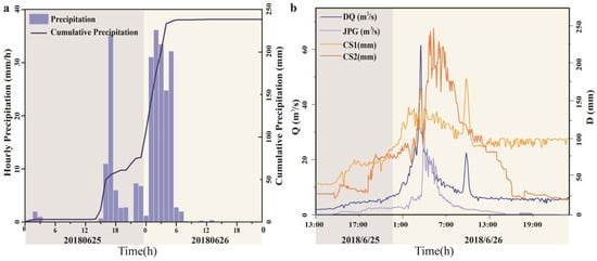
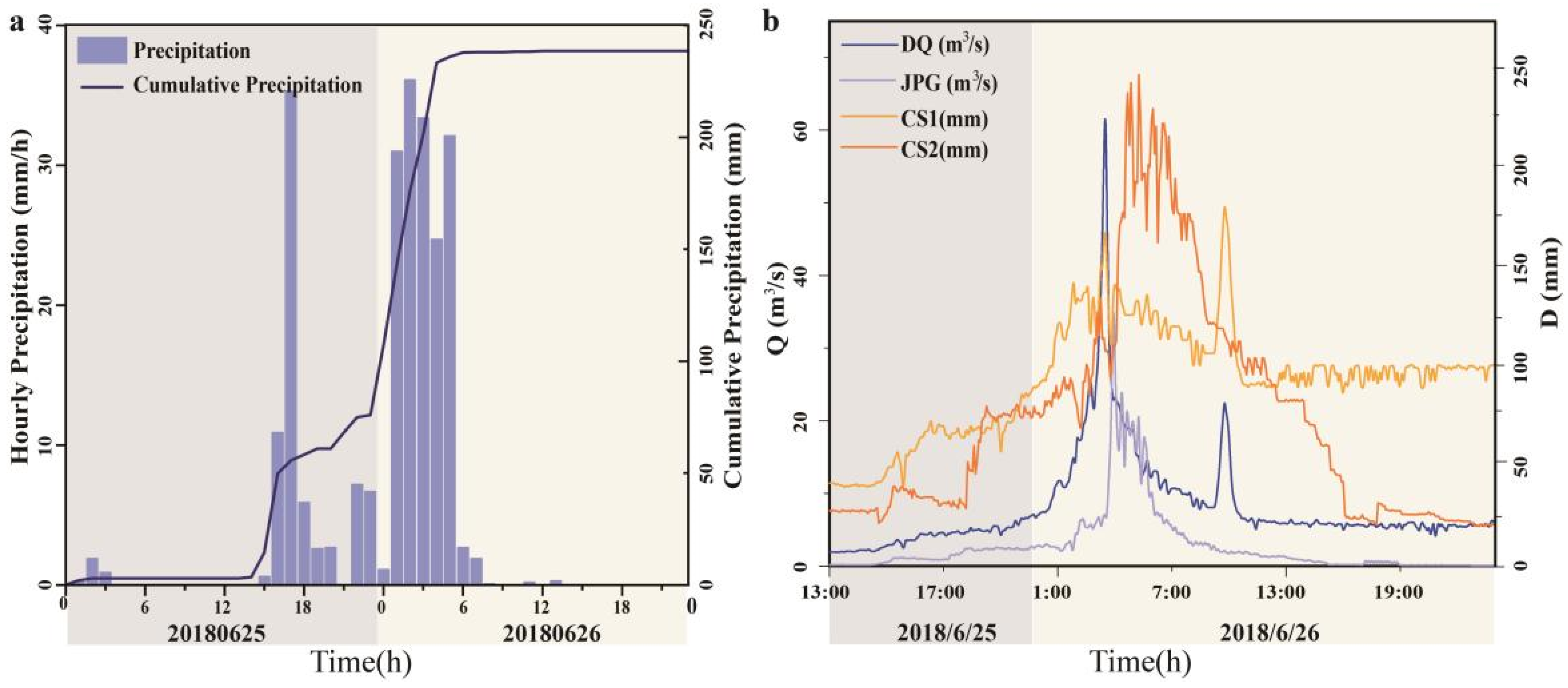
From inspection of the precipitation record, a large flash flood event on 25 and 26 June 2018, in Longxi River were selected for analysis, with the maximum hourly rainfall intensity of 37.2 mmh−1 and cumulated values up to 219.7 mm in 13 h (Figure 3).
Figure 3.
Characteristics of monitoring data in Longxi River: (a). Hourly precipitation from 25 June to 26 June 2018 (b). Hydrological and hydraulic parameters in the monitoring cross sections including the discharge and critical size of the movement.
Based on field observations and the measurement, the peak velocities are 2.19 m/s and 6.07 m/s, respectively, located at the middle of the study reach (CS1, in Figure 2a) and the outlet of Jianping Gully (CS2, in Figure 2a) [17]. The peak discharge values in these places are 65.25 m3/s and 39.02 m3/s, and the values of unit peak discharge range from 1.59 to 10.96 m3/(s km2). According to the hydrological data of the gauge stations in the study region, the shear stress () and the critical size of movement (Dc) were calculated during the flash flood by Equation (1) and Equation (2). The result (Figure 3) shows the maximum shear stress at CS1 and CS2 (Figure 2) could carry away about 0.22~0.25 m of materials during this flash flood.
3.2. Classification of Channels
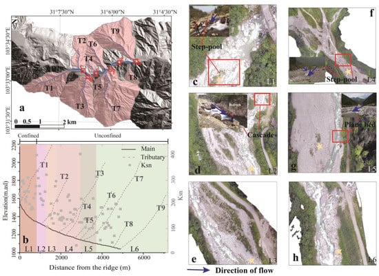
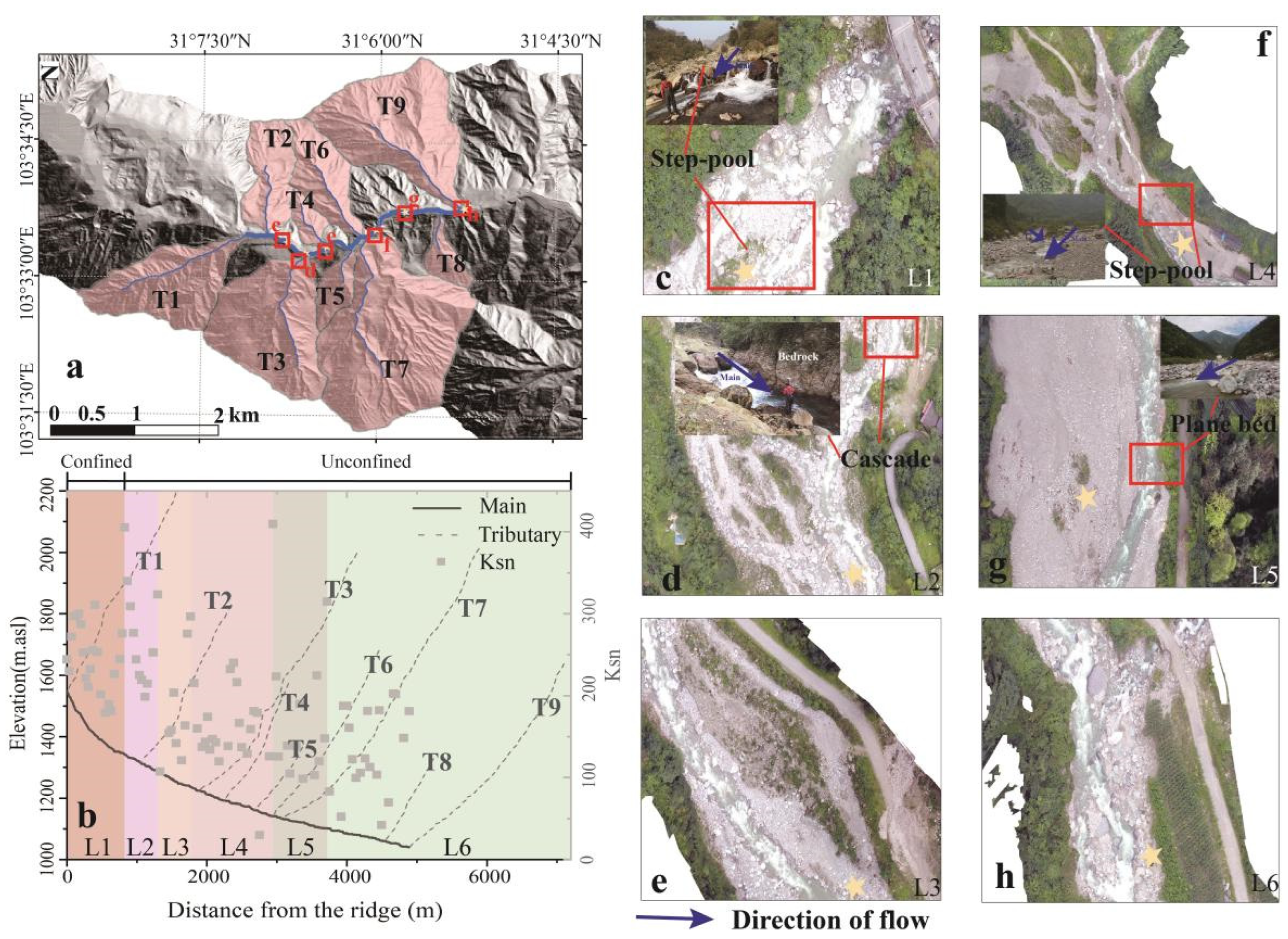
According to the division method given in Section 2.2, the studied channel could be divided into six parts (Figure 4a). First, according to the VCA, the channel could be divided into a confined channel (L1) and an unconfined channel (L2–L6). Besides, according to the steepness index analysis, there is a knickpoint in the longitudinal profile at the junction of the confined channel and unconfined channel (Figure 4b,c). A boulder-filled riverbed and a high cohesion alluvial bank which consist of clay materials, limited the channel’s expansion and the bed’s erosion, leading to the local knickpoint. In the unconfined channel, because of the channel’s topology and the inflows of the water and material from the tributaries, four local knickpoint were generated, which divided the unconfined channel into five parts. These four knickpoints were located downstream of the main channel and tributaries (Figure 4b,d) because the mass of materials, including boulders, were transported by the previous events, such as landslide, collapse, and debris flow, limiting the erosion of channel. The result of division by the transverse and longitudinal aspects was compared with the aerial photographs taken in the field (Figure 4c–h).
Figure 4.
Division of the study channel in Longxi River: (a,b) showed the study channel’s division in Longxi River. L1–L6 represents the different parts along the main channel, and the T1–T9 represents the different tributaries along the river. (c–h) displayed the characteristics of different parts by the UAV image taken on 4 July 2018.
Summary characteristics of the different reaches of the study channel of Longxi River, including gradient and width, are shown in Table 1. The channel’s width in the unconfined channel is more significant than that in the confined channel and with a broader range of values. And the gradient is lower in the unconfined channel than in the confined channel, which was further reduced by the accumulation of debris flow in the channel (Table 1).
Table 1.
Characteristics of different parts.
The riverbed structure and the composition of the riverbed have an important influence on the redistribution of energy in the dynamic flow system. The structure of the riverbed in different parts of the Longxi River varies. In the confined channel, the step-pools occur with a height of 0.5–1.4 m and lengths of 5.97–6.98 m (Figure 4c). The unconfined channel structure plane beds dominate with few cascades and step-pools. Cascades are found in the L2 because of the bedrock control (Figure 4d). Step-pools mainly occur in the unconfined channel at the junction of the main channel of Longxi River and tributaries, such as within L3 and L4 (Figure 4f). Because of the channel expansion and deposition by the previous debris flows, the channel’s gradient immediately downstream was relatively low, with plane beds predominating, such as within L5 and L6 (Figure 4g).
3.3. Morphological Response of the Channel to the Flash Flood
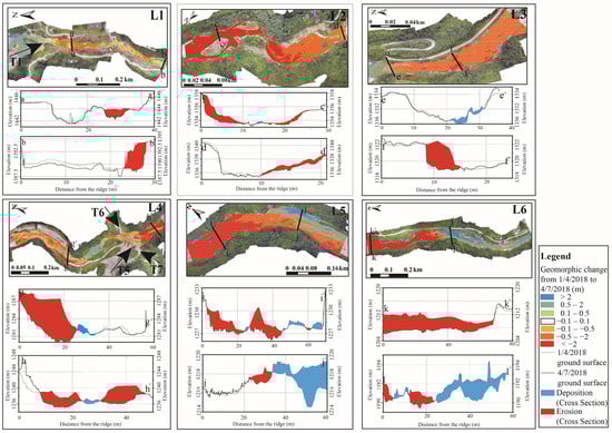
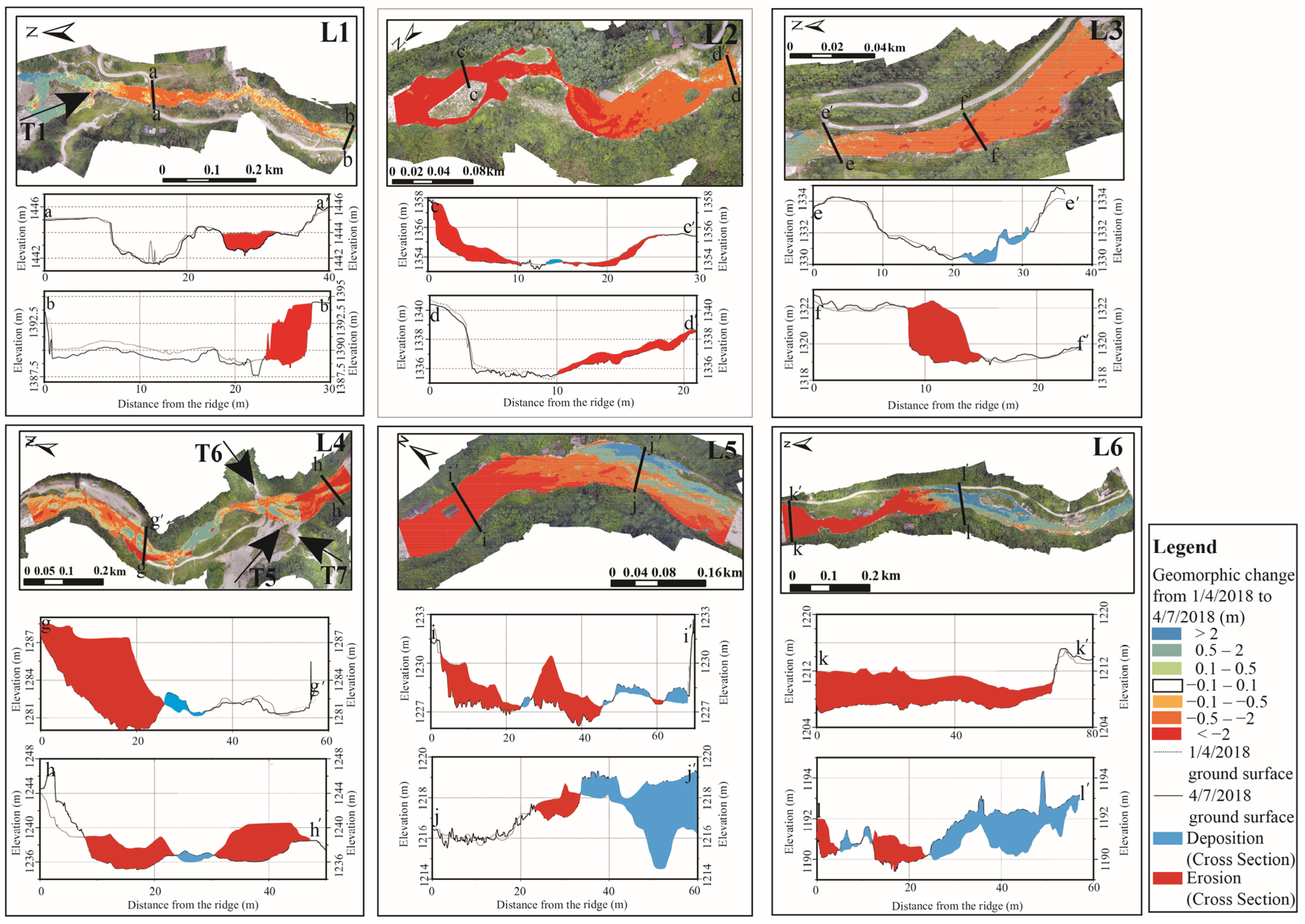
After a flash flood, the response of different reaches has differed. For the first part (confined channel) (Figure 5L1), the undercutting of the river banks and basal scour were both limited by the resistant bank materials and by boulders in the riverbed, which were introduced by the earthquake and subsequent debris flows. Riverbank destabilizing occurred mainly when the original road, composed of finer gravel, was adjacent to the river channel. Further, the lateral extension of the channel just occurred in only a few areas by basal erosion of adjacent hillslope, exacerbated by the disruption of vegetation cover (Figure 5L1, Table 2). According to DoDs analysis, cross-section profiles highlighted the pronounced basal incision with an elevation change of about 2 m (Figure 5L1 a–a′) and lateral erosion of about 3 m (Figure 5L1 b–b′) along the main channel. The results showed about 7300 m3 of deposition within the confined reach close to the junction of the main channel and tributary, but there was a loss of about 6000 m3 of sediment along the main channel from the junction to the end of this part (Figure 5L1, Table 2). The erosion within the confined channel was primarily basal, with the change of bed elevation ranging from 0.2 m to 2 m, and lateral erosion carried away loose material which had been deposited in previous debris flows. Overall, the confined channel mainly displayed little change, with an average change height of 0.0133 m.
Figure 5.
Changes of the channel after this flash flood. L1–L6 represent the geomorphic changes of overall channel parts and cross sections in different parts from upstream to downstream in the study area. Among them, L1 represents the most upstream part and L6 represents the most downstream part. a–a′ to l–l′ represent the cross sections in different parts. T1, T5–T7 represent the tributaries along the study area.
Table 2.
Characteristics of channel changes in the different parts of the channel.
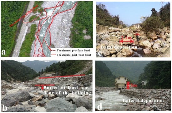
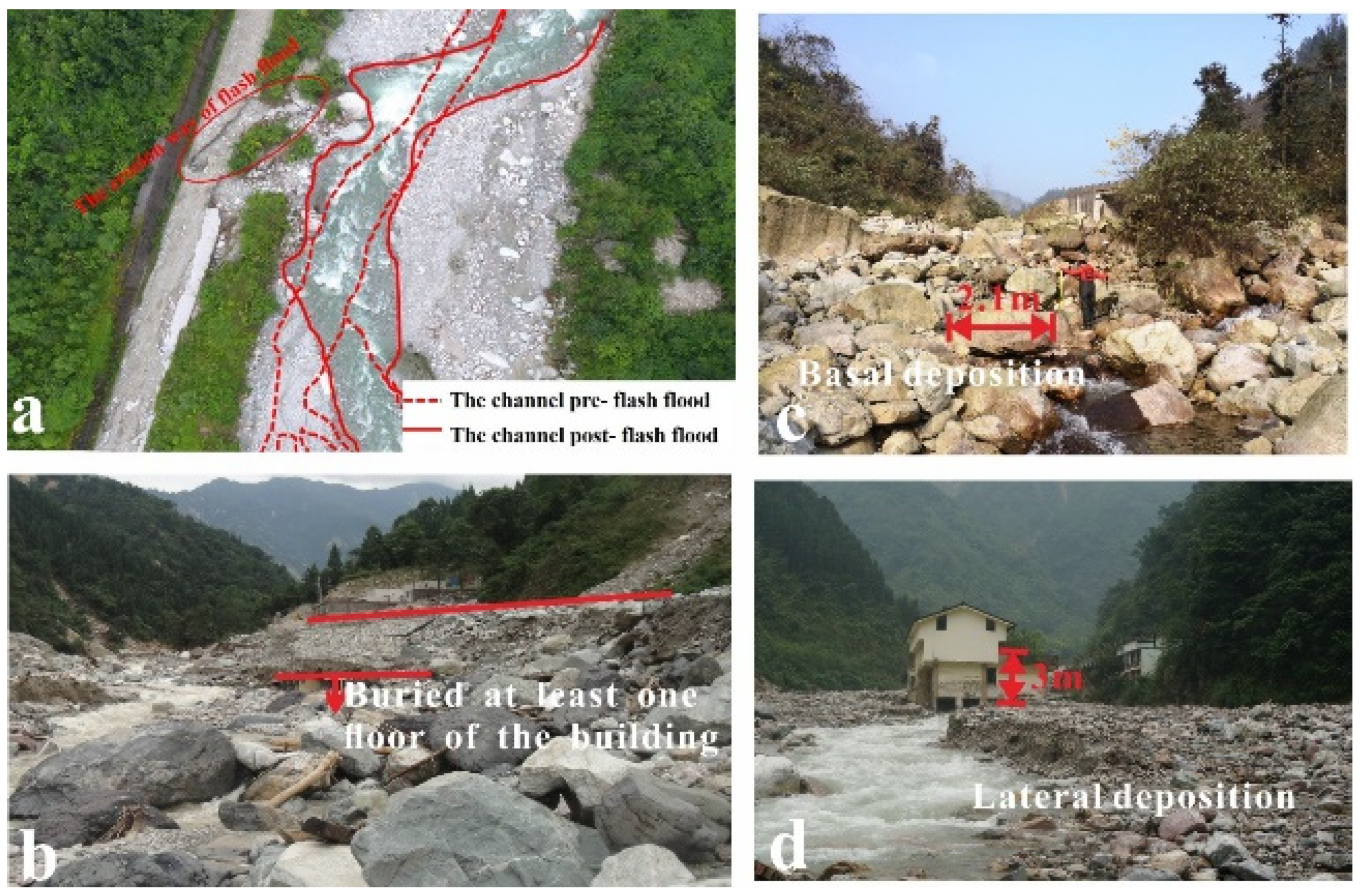
In contrast, the unconfined channel showed a more noticeable change in the degree of lateral channel migration because of different hydrological and topographic conditions. The changes of average parts in these parts range from 0.1013 m to 0.5664 m, and the process of erosion and deposition was more severe than that in confined channels. Based on the overall analysis of the unconfined channel, it was found that the unconfined channel widened significantly under the action of the flash flood (Figure 6a), and the lateral erosion was severe. As a result of previous debris flows, the Longxi River has been significantly elevated, especially in the unconfined channel, by about 10 m (Figure 6b). The existing channel is located on the body of debris flow, composed of loose materials on both banks and the bottom of the channel. However, the loose material at the bottom of the riverbed becomes armored, so the surface cover is not easily entrained (Figure 6c). However, at the channel margins, the finer debris flow materials are without the protection of the armour layer and are readily mobilized after a flash flood, resulting in significant lateral erosion (Figure 6d).
Figure 6.
Morphological change and characteristics of the unconfined channel: (a). Extension of the channel in the unconfined channel part occurred by 4 July 2018; (b) Elevation of the channel bed in the unconfined channel occured by 22 August 2010; (c) Basal deposition occurred by 4 July 2018, (d). Lateral deposition occurred by 4 July 2018.
According to the DoDs analysis, the inflows of tributaries influenced the response in the different parts. For example, the inflow of T3 led to the 7450 m3 deposition in the L3, and the inflow of T4–T7 intensified the lateral erosion of the riverbed in the L4 and L5 (Figure 5).
4. Discussion
4.1. Effects of the Armour Layer on the Channel Response
Hydraulic conditions directly affect the transportation of material and the intensity and evolution of the channel. Because of the limitation of the hydrological monitoring section, the dynamic conditions of the most dramatic position of channel change were not discussed. According to other researchers [32,62], the higher shear stress will take away more materials, which will form new lateral channels within the floodplain and extend the channel, especially in the unconfined channel.
The earthquake and subsequent landslides would take the large materials from upstream and slope to the main channel, which leads to the riverbed being poorly sorted. After the washing by perennial flow, flash flood, and debris flow move down the small grains to fill gaps vacated by the entrainment of large grains, which might generate a layer in the channel by kinetic sieving [63,64,65,66] (Figure 5b,c). Based on the data obtained in Longxi River, the armour layer effect generated by the earthquake on the channel response was analyzed in this part.
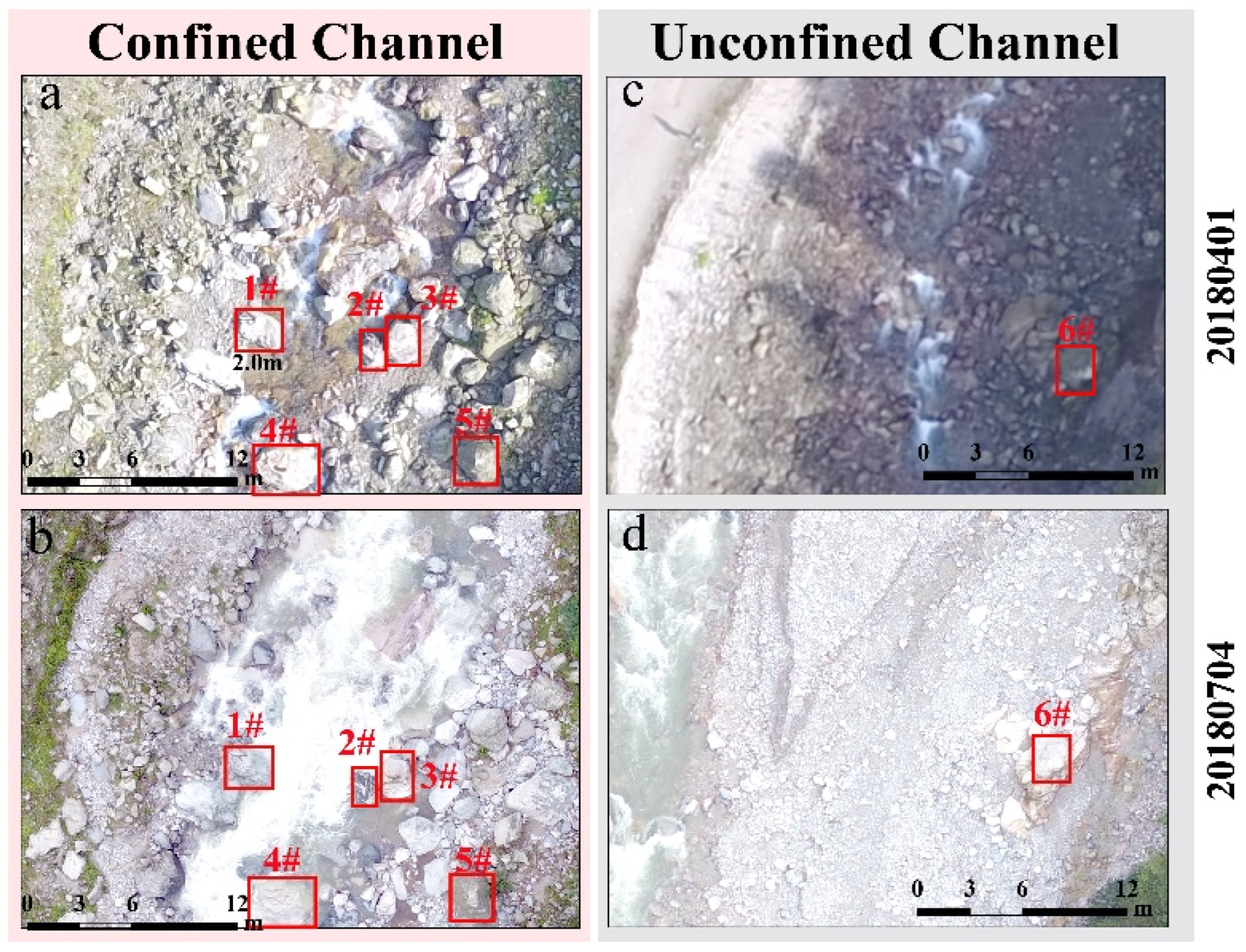
The effect of the coarse layer on the channel response was more evident in the confined channel. According to the division of the channel and the computation of hydrodynamic conditions, it could be found the confined channel has a more significant shear stress with a larger capacity of basal transportation than the unconfined channel because of the smaller channel width. However, analyzing the channel change response after a flash flood, it was found that the change of the confined channel is slighter than the unconfined channel, which is mainly due to the steeper slope and the confined bankfull. Broad slopes are not conducive to the long-term retention of loose material, and the material tends to move towards a smoother slope [67,68]. Due to the scouring ability of the confined channel and the relatively less accumulated material, it is easy to transport the fine material from the bottom of the riverbed downstream under the action of post-earthquake debris flow and flash flood. A decade after the Wenchuan Earthquake, the basal riverbed of the confined channel was composed of about 1 m large rocks, making the riverbed structure of the confined channel mainly composed of step-pool, and the supply-limited process controlled the transportation in the confined channel (Figure 4 and Figure 7a,b).
Figure 7.
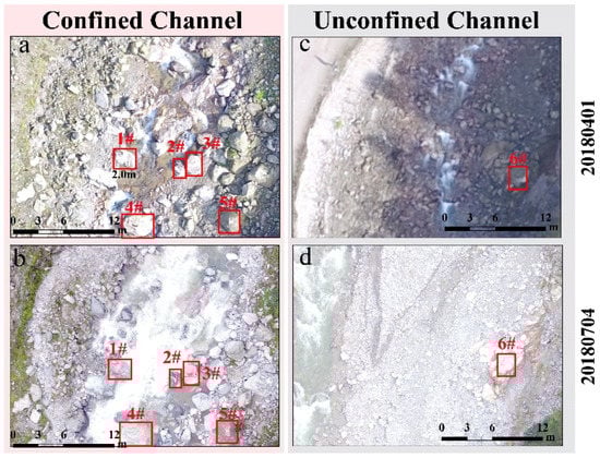
Distribution of grain in different channel part. (a,b) show the coarse layer generated in confined channel, box 1–6 shows the location of reference grains without moving under this flash flood; (c,d) show the unconfined channel with gravel and clay and little boulder.
By contrast, the coarse layer did not generate in the unconfined channel, and the channel change response to a flash flood was more severe. The extension of the channel in the unconfined channel is significant after the earthquake. Under the same flow conditions, the shear stress of unconfined channels is less than that of confined channels because of the extended channel. In other words, the discharge of moving rocks of the same size needs to be larger. However, according to the law of material transportation in mountainous areas, the particle size in the lower reaches of the channel is smaller than that in the upper reaches by sorting (Figure 7c,d) [69,70,71]. Due to the less confinement of the unconfined channel, many debris flow materials were deposited here after the Wenchuan earthquake. So, the transportation of material in this region is dominated by the transport-limited process. It is more comfortable to cause drastic erosion and deposition or the channel’s migration (Figure 6).
4.2. Effect of the Tributary and Channel width on the Channel Response
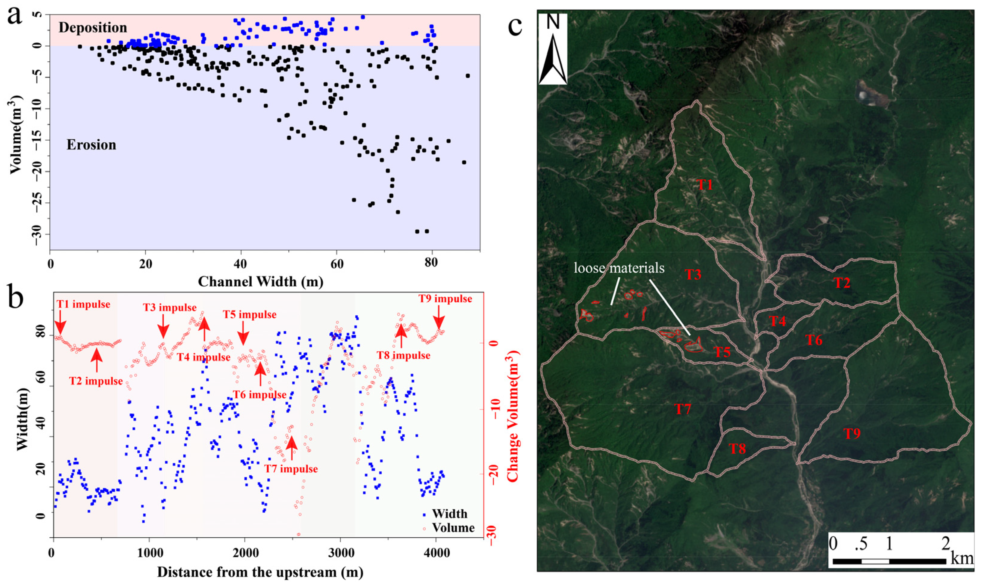
Due to the complex distribution of the tributary and different channel widths in the Longxi River, different channel responses occurred, such as L1, L3, and L4. In order to analyze the effect of the channel width, the relationship between channel width and the volumetric change by this flash flood was obtained (Figure 8a). It was found that channel width controlled the change of channel. The larger channel width would have more space for deposition and accommodate more loose material to be eroded. By contrast, the erosion and deposition showed a slight change post-flash flood in the channel with a small width. According to the simulation result by Cook et al. [72], the effects of channel width are different in different discharges. Wide channels have a higher transport capacity than narrow ones with the same bed slope at high discharges, corresponding with the channel volumetric change post-flash flood in the Longxi River. Besides, the increasing channel width wasn’t evident, corresponding with the increasing volumetric change, which might be influenced by the impulse of the tributary, which might increase the supply of loose materials and the discharge.
Figure 8.
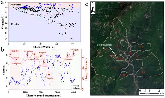
Effect of the channel width and impulse of tributaries to the volumetric change post-flash flood. (a) shows the relationship between channel width and volume change during a flash flood; (b) shows the change of channel width and volume change along the channel with the influence of tributaries inflow; (c) shows the distribution of loose materials in different tributaries.
Complex tributaries provided generous impulse of water and sediment for the main channel. Longxi River is a watershed with complex tributaries that significantly influence the geomorphic response of flash flood in different parts. The channel width and volume of change in the confluence were increased by the composition of tributary mass supply or erosion by increasing discharge from the tributary (Figure 8b). Due to the different water and sediment supply, the confluences in different parts had different responses during a flash flood. In part L3, the tributary (T3) provides more sediment than water, making the deposition occur and increasing the channel width and elevation in the confluence (Figure 8). In part L4, tributaries (T6 and T7) along the Longxi channel provided more water than mass for the main channel, increasing the main flow’s capacity to erode the channel. Besides, T5 also provides more sediment for the main channel and leads to deposition in the main channel before T6 inflow to the main channel. To analyze the effect of the tributary to the channel change during this flash flood, the satellite images obtained by Sentinel 2 were selected to analyze the capacity of loose material supply in different tributaries. The image shows that the loose materials in T3 and T5 were relatively more than in T6 and T7. T6 and T7 were covered by vegetation (Figure 8c).
4.3. Geomorphological Evolutions Triggered by the Flash Flood in the Strong Earthquake-Affected Catchment
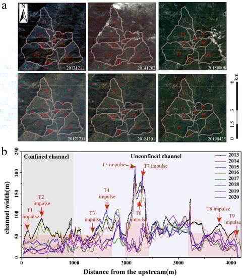
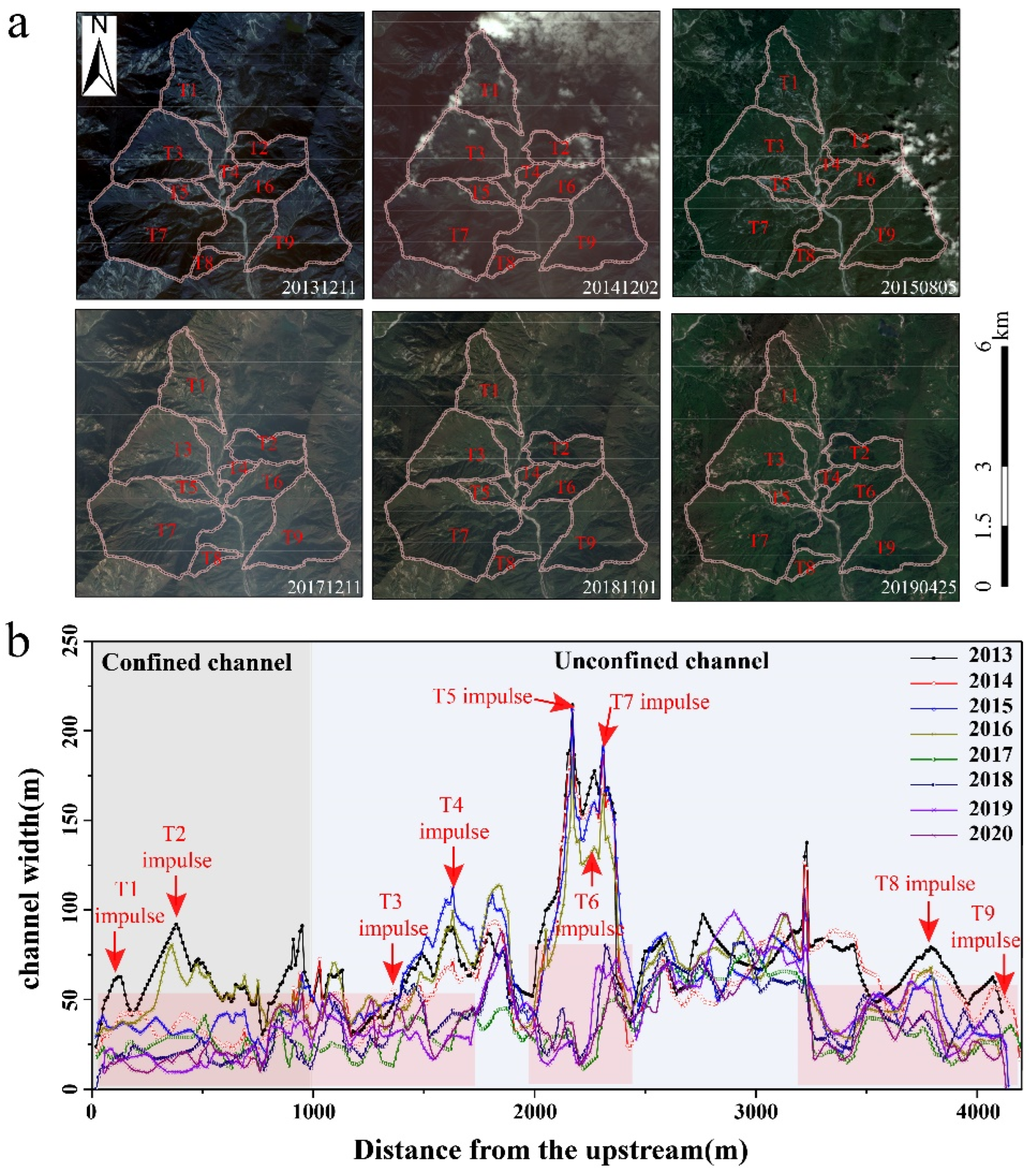
Several researches have shown that the loose soil deposits in earthquake-affected catchments have covered from hillslope to channel and the channel has experienced evolution several times [4,73]. According to the previous study and the satellite images from GaoFen-1 and Sentinel-2, the events of mass transformation were collected. It was found that there was a milestone in the transformation of mass transportation from the post-earthquake debris flow to the flash flood. Before 2013, several debris flow events occurred at Longxi River recorded by the previous study [74,75]. To analyze the evolution of the debris flow, several satellite images from 2013 to 2020 were obtained. And the images showed that the land cover remained unchanged after the debris flow occurred on 8 August 2013 (Figure 9a). It shows the mass supply in this period was limited by vegetation recovery. The debris flow was substituted by the flash flood to transport the mass deposited in the channel, which is also supported by the monitoring data [17]. And according to the extraction of channel width along the main channel at different periods, it shows the channel width was up the maximum after the debris flow occurred on 8 August 2013, and kept this width until 2016. After 2016, the vegetation was recovered at the accumulative body in the channel, and the channel width was reduced. Besides, the tributary influence was also reduced because of the reduced capacity of mass supply from a tributary.
Figure 9.
Change of the land cover and channel width of Longxi River after the debris flow events occurred on 8 August 2013. (a) shows the series Sentinel-2 images in study reach (https://glovis.usgs.gov/app, accessed on 29 November 2022), from which the channel width was obtained by visual interpretation; (b) shows the change of channel width in different period along the channel.
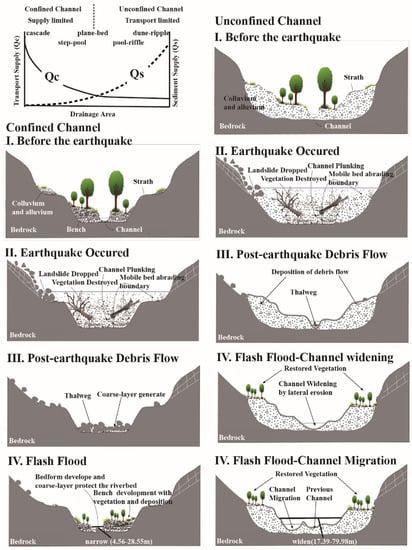
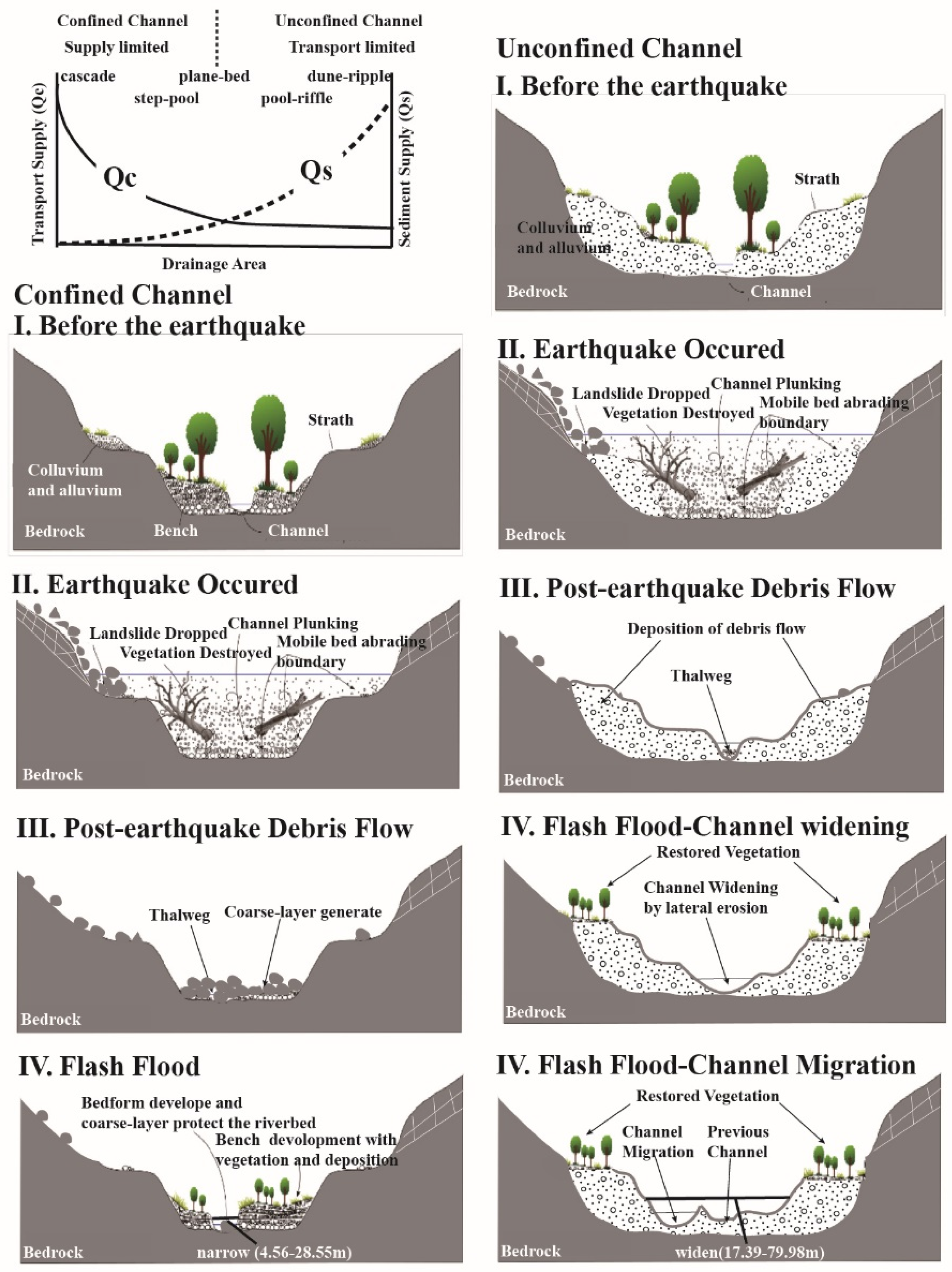
One conceptual model of generalized channel response to floods in an earthquake-affected catchment was put forward based on the Longxi River analysis. The influence of the earthquake on channel evolution can be divided into three stages. In the first stage, a large amount of loose material was produced and transported to the main channel through post-earthquake debris flow, which caused and blocked the channel and consequently uplifted the riverbed. In the second stage, under the effect of post-earthquake debris flow, part of the debris flow material deposited in the channel was removed. The transport-limited process controlled the channel evolution. In the third stage, which has passed a long time after the earthquake, the flash flood was the main external force of erosion or channel accumulation, leading to the loose materials generated by earthquake transport to downstream even outside of the watershed. Because of the difference in supply and transport capacity, the conceptual model divides the post-earthquake geomorphological response of flash floods into three main categories (Figure 10).
Figure 10.
Conceptual diagram of the channel response to floods in an earthquake-affected catchment. The conceptual diagram for sediment transportation and supply was modified from [26,42].
The first kind of channel mainly occurred in the confined channel without typical knickpoint, such as the L1 in Longxi River (Figure 5). The structure of the riverbed is mainly composed of the step-pool, which is hard to be destroyed and keep stable during a flash flood [76,77,78]. After a flash flood, the gradient in this kind of channel tends to be flatter from 94.05‰ to 93.22‰, and the width of the channel was narrow with a minimum value of 4.5 m. But the change is not evident with the average height of 0.0133 m due to the protection of the coarse layer generated by the earthquake and post-earthquake debris flow (Figure 8). The capacity of transportation is stronger than the capacity of supply, and the main channel change in the confined channel is erosion.
The second kind of channel has mainly occurred in the unconfined channel without the inflow of tributaries, such as L2 in Longxi River (Figure 5). The lateral erosion would remove the bench composed of the loose material of post-earthquake debris flow during a flash flood, and the channel would be widened and the width of the channel was more than the first type with the maximum value of 44.98 m. And the supply capacity is stronger than the transportation capacity in this type, and the transportation capacity controls the movement of materials. During a flash flood, the water depth is not over the bank and just swept away the deposition of the bottom, which led the slope to slump and the channel to widen (Figure 10).
The third is mainly distributed in the unconfined channel with the inflow of tributaries, such as L3~L6 in Longxi River (Figure 5). Because of the inflow of tributaries and the widened channel with a width range from 17.39 m to 79.78 m, the level of water during the flash flood would be uplifted and spilled over the bank. The material would be spilled away along the flow path, generating a new thalweg (Figure 10).
4.4. Limitations
DSM derived by sUAV, as one of the key data for quantitative analysis in this study, was processed and analyzed using uniform error analysis [22,61]. It has little effect on the overall trend and location distribution of channel evolution. However, the limitations of uniform error estimates were confirmed by overestimating errors, especially on more complex, sloping surfaces [79]. And it will lead to overestimation of net erosion and deposition in DSM-based sediment budget estimates [80,81,82]. Therefore, in the analysis of this paper, the analysis of channel evolution at different locations under the action of flash floods cannot better establish the quantitative relationship in watershed scale and only analyze the changes and trends of local sections or cross-sections. This brings constraints to the quantitative analysis of transport between different parts in this paper.
5. Conclusions
A high-magnitude flash flood, which occurred on 25 and 26 June 2018 in Longxi River with elaborated meteorological, hydrological, and sUAV data, was selected to quantify the channel evolution by the flash flood in an earthquake-affected region. The event was characterized by intense bedload transport with basal erosion and lateral erosion. Six sections and two types (confined and unconfined channels) with exclusive channel characteristics were distinguished based on the confinement index and steepness index, analyzing the geomorphic channel response in more detail.
The controls on channel changes triggered by the large flash flood were determined and evaluated, such as the coarsening layer, channel width, and river confluence. At the basin scale, the confined channel is with little change under this flash flood and the channel evolution of the unconfined channel is sensitive to the flash flood. The coarsening layer can protect the channel and resist the drastic change after the event with only a little channel bed change. In an unconfined channel, the change could reach 6 m without the protection of the coarsening layer. In river confluences, higher intense erosion with a large volume of about 105 m3 mostly appeared in downstream of tributaries. In the cross-sections, the increased channel width could lead to significant deposition and erosion with a large volume of 35 m3.
We proposed a conceptual diagram of the generalized channel response to large flash floods explaining the multi-stage of post-earthquake channel evolutions and determined its rebalance stage in the tenth year after the earthquake. These findings will contribute to understanding the post-earthquake long-term channel evolutions triggered by large flash floods in the earthquake-affected watershed. Meanwhile, the development of sUAV processing could provide us with more opportunities to strengthen 3D morphological analysis in the future.
Author Contributions
Conceptualization, W.J. and H.W.; Funding acquisition, G.Z.; Investigation, W.J., H.W. and D.L.; Methodology, W.J. and H.W.; Resources, W.J., H.W., G.Z., D.L. and J.W.; Writing—original draft, W.J.; Writing—review & editing, G.Z., D.L. and J.W. All authors have read and agreed to the published version of the manuscript.
Funding
This research was funded by the National Natural Science Foundation of China (Grant No. U21A2008), the National Postdoctoral Program for Innovative Talents (Grant No. BX20220293) and the National Natural Science Foundation of China (Grant No. 42201088). Besides, this research was also supported by Key Research Program of Frontier Sciences, CAS (Grant No. QYZDY-SSW-DQC006), China Postdoctoral Science Foundation (Grant No. 2021M703180) and the Special Research Assistant program of the Chinese Academy of Sciences.
Institutional Review Board Statement
Not applicable.
Informed Consent Statement
Not applicable.
Data Availability Statement
Not applicable.
Acknowledgments
Thanks Paul A. Carling for reviewing and editing this paper.
Conflicts of Interest
The authors declare no conflict of interest.
Appendix A. Parameters Description
This section provides definitions for the Parameters used in this paper.
Table A1.
Parameters Description in this paper.
References
- Marc, O.; Hovius, N.; Meunier, P. The mass balance of earthquakes and earthquake sequences. Geophys. Res. Lett. 2016, 43, 3708–3716. [Google Scholar] [CrossRef] [Scilit]
- Cui, P.; Chen, X.-Q.; Zhu, Y.-Y.; Su, F.-H.; Wei, F.-Q.; Han, Y.-S.; Liu, H.-J.; Zhuang, J.-Q. The Wenchuan Earthquake (12 May 2008), Sichuan Province, China, and resulting geohazards. Nat. Hazards 2011, 56, 19–36. [Google Scholar] [CrossRef] [Scilit]
- Dadson, S.J.; Hovius, N.; Chen, H.; Dade, W.B.; Lin, J.-C.; Hsu, M.-L.; Lin, C.-W.; Horng, M.-J.; Chen, T.-C.; Milliman, J.; et al. Earthquake-triggered increase in sediment delivery from an active mountain belt. Geology 2004, 32, 733–736. [Google Scholar] [CrossRef] [Scilit]
- Zhang, S.; Zhang, L.; Lacasse, S.; Nadim, F. Evolution of Mass Movements near Epicentre of Wenchuan Earthquake, the First Eight Years. Sci. Rep. 2016, 6, 36154. [Google Scholar] [CrossRef] [Scilit] [PubMed]
- An, C.; Cui, Y.; Fu, X.; Parker, G. Gravel-bed river evolution in earthquake-prone regions subject to cycled hydrographs and repeated sediment pulses. Earth Surf. Processes Landf. 2017, 42, 2426–2438. [Google Scholar] [CrossRef] [Scilit]
- Zhang, G.; Cui, P.; Jin, W.; Zhang, Z.; Wang, H.; Bazai, N.A.; Li, Y.; Liu, D.; Pasuto, A. Changes in hydrological behaviours triggered by earthquake disturbance in a mountainous watershed. Sci. Total Environ. 2021, 760, 143349. [Google Scholar] [CrossRef] [Scilit]
- Hapuarachchi, H.A.P.; Wang, Q.J.; Pagano, T.C. A review of advances in flash flood forecasting. Hydrol. Processes 2011, 25, 2771–2784. [Google Scholar] [CrossRef] [Scilit]
- Francis, O.; Fan, X.; Hales, T.; Hobley, D.; Xu, Q.; Huang, R. The Fate of Sediment After a Large Earthquake. J. Geophys. Res. Earth Surf. 2022, 127, e2021JF006352. [Google Scholar] [CrossRef] [Scilit]
- Bazai, N.A.; Cui, P.; Carling, P.A.; Wang, H.; Hassan, J.; Liu, D.; Zhang, G.; Jin, W. Increasing glacial lake outburst flood hazard in response to surge glaciers in the Karakoram. Earth-Sci. Rev. 2021, 212, 103432. [Google Scholar] [CrossRef] [Scilit]
- Liu, D.; Cui, Y.; Wang, H.; Jin, W.; Wu, C.; Bazai, N.A.; Zhang, G.; Carling, P.A.; Chen, H. Assessment of local outburst flood risk from successive landslides: Case study of Baige landslide-dammed lake, upper Jinsha river, eastern Tibet. J. Hydrol. 2021, 599, 126294. [Google Scholar] [CrossRef] [Scilit]
- Hooke, J.M. Variations in flood magnitude–effect relations and the implications for flood risk assessment and river management. Geomorphology 2015, 251, 91–107. [Google Scholar] [CrossRef] [Scilit]
- Stoffel, M.; Wyżga, B.; Marston, R.A. Floods in mountain environments: A synthesis. Geomorphology 2016, 272, 1–9. [Google Scholar] [CrossRef] [Scilit]
- Krapesch, G.; Hauer, C.; Habersack, H. Scale orientated analysis of river width changes due to extreme flood hazards. Nat. Hazards Earth Syst. Sci. 2011, 11, 2137–2147. [Google Scholar] [CrossRef] [Scilit]
- Lucía, A.; Schwientek, M.; Eberle, J.; Zarfl, C. Planform changes and large wood dynamics in two torrents during a severe flash flood in Braunsbach, Germany 2016. Sci. Total Environ. 2018, 640–641, 315–326. [Google Scholar] [CrossRef] [Scilit]
- Belletti, B.; Dufour, S.; Piégay, H. Regional assessment of the multi-decadal changes in braided riverscapes following large floods (Example of 12 reaches in South East of France). Adv. Geosci. 2014, 37, 57–71. [Google Scholar] [CrossRef] [Scilit]
- Hauer, C.; Habersack, H. Morphodynamics of a 1000-year flood in the Kamp River, Austria, and impacts on floodplain morphology. Earth Surf. Processes Landf. 2009, 34, 654–682. [Google Scholar] [CrossRef] [Scilit]
- Zhang, G.; Cui, P.; Yin, Y.; Liu, D.; Jin, W.; Wang, H.; Yan, Y.; Ahmed, B.N.; Wang, J. Real-time monitoring and estimation of the discharge of flash floods in a steep mountain catchment. Hydrol. Processes 2019, 33, 3195–3212. [Google Scholar] [CrossRef] [Scilit]
- Thomas, J.; Joseph, S.; Thrivikramaji, K.P. Morphometric aspects of a small tropical mountain river system, the southern Western Ghats, India. Int. J. Digit. Earth 2010, 3, 135–156. [Google Scholar] [CrossRef] [Scilit]
- Guzzetti, F.; Mondini, A.C.; Cardinali, M.; Fiorucci, F.; Santangelo, M.; Chang, K.-T. Landslide inventory maps: New tools for an old problem. Earth-Sci. Rev. 2012, 112, 42–66. [Google Scholar]
- Lucía, A.; Comiti, F.; Borga, M.; Cavalli, M.; Marchi, L. Dynamics of large wood during a flash flood in two mountain catchments. Nat. Hazards Earth Syst. Sci. 2015, 15, 1741–1755. [Google Scholar] [CrossRef] [Scilit]
- Entwistle, N.; Heritage, G.; Milan, D. Recent remote sensing applications for hydro and morphodynamic monitoring and modelling. Earth Surf. Processes Landf. 2018, 43, 2283–2291. [Google Scholar] [CrossRef] [Scilit]
- Alfonso-Torreno, A.; Gomez-Gutierrez, A.; Schnabel, S.; Lavado Contador, J.F.; de Sanjose Blasco, J.J.; Sanchez Fernandez, M. sUAS, SfM-MVS photogrammetry and a topographic algorithm method to quantify the volume of sediments retained in check-dams. Sci. Total Environ. 2019, 678, 369–382. [Google Scholar] [CrossRef] [Scilit] [PubMed]
- Lewis, Q.W.; Edmonds, D.A.; Yanites, B.J. Integrated UAS and LiDAR reveals the importance of land cover and flood magnitude on the formation of incipient chute holes and chute cutoff development. Earth Surf. Processes Landf. 2020, 45, 1441–1455. [Google Scholar] [CrossRef] [Scilit]
- Woodget, A.S.; Carbonneau, P.E.; Visser, F.; Maddock, I.P. Quantifying submerged fluvial topography using hyperspatial resolution UAS imagery and structure from motion photogrammetry. Earth Surf. Processes Landf. 2015, 40, 47–64. [Google Scholar] [CrossRef] [Scilit]
- Leopold, L.; Maddock, T. The Hydraulic Geometry of Stream Channels and Some Physiographic Implication; US Government Printing Office: Washington, DC, USA, 1953; pp. 1–57.
- Lane, E. The importance of fluvial morphology in hydraulic engineering. Am. Soc. Civ. Eng. 1955, 81, 1–17. [Google Scholar] [CrossRef] [Scilit]
- Montgomery, D.R.; Buffington, J.M. Channel Classification, Prediction of Channel Response, and Assessment of Channel Condition; SHAMW Committee of the Washington State Timber/Fish/Wildlife Agreement: Washington, DC, USA, 1993. [Google Scholar]
- Brardinoni, F.; Hassan, M.A. Glacial erosion, evolution of river long profiles, and the organization of process domains in mountain drainage basins of coastal British Columbia. J. Geophys. Res. 2006, 111, 1–12. [Google Scholar] [CrossRef] [Scilit]
- Montgomery, D.R.; Foufoula-Georgiou, E. Channel Network Source Representation Using Digital Elevation Models. Water Resour. Res. 1993, 29, 3925–3934. [Google Scholar] [CrossRef] [Scilit]
- Nagel, D.E.; Buffington, J.M.; Parkes, S.L.; Wenger, S.; Goode, J.R. A Landscape Scale Valley Confinement Algorithm: Delineating Unconfined Valley Bottoms for Geomorphic, Aquatic, and Riparian Applications; U.S. Department of Agriculture, Forest Service, Rocky Mountain Research Station: Fort Collins, CO, USA, 2014.
- Thompson, C.; Croke, J. Geomorphic effects, flood power, and channel competence of a catastrophic flood in confined and unconfined reaches of the upper Lockyer valley, southeast Queensland, Australia. Geomorphology 2013, 197, 156–169. [Google Scholar] [CrossRef] [Scilit]
- Scorpio, V.; Crema, S.; Marra, F.; Righini, M.; Ciccarese, G.; Borga, M.; Cavalli, M.; Corsini, A.; Marchi, L.; Surian, N.; et al. Basin-scale analysis of the geomorphic effectiveness of flash floods: A study in the northern Apennines (Italy). Sci. Total Environ. 2018, 640–641, 337–351. [Google Scholar] [CrossRef] [Scilit]
- Harvey, A.M. Coupling between hillslopes and channels in upland fluvial systems: Implications for landscape sensitivity, illustrated from the Howgill Fells, northwest England. CATENA 2001, 42, 225–250. [Google Scholar] [CrossRef] [Scilit]
- He, C.-R.; Zhang, R.; Chen, Q.; Han, S.-L. Earthquake characteristics and building damage in high-intensity areas of Wenchuan earthquake I: Yingxiu town. Nat. Hazards 2010, 57, 435–451. [Google Scholar] [CrossRef] [Scilit]
- Li, J.; Yu, B.; Zhu, Y.; Chu, S.; Wu, Y. Topographical factors in the formation of gully-type debris flows in Longxi River catchment, Sichuan, China. Environ. Earth Sci. 2014, 73, 4385–4398. [Google Scholar] [CrossRef] [Scilit]
- Biyun, G.; Xudong, F.; Zhengfeng, Z. The Longitudinal Change and Gully Bed Fractality of Longxi River Valley After the Earthquake. J. Basic Sci. Eng. 2014, 22, 118–128. (In Chinese) [Google Scholar]
- Xu, Q.; Zhang, S.; Li, W.L.; van Asch, T.W.J. The 13 August 2010 catastrophic debris flows after the 2008 Wenchuan earthquake, China. Nat. Hazards Earth Syst. Sci. 2012, 12, 201–216. [Google Scholar] [CrossRef] [Scilit]
- Meyer-Peter, E.; Müller, R. Formulas for Bed-Load Transport; IAHR: Stockholm, Sweden, 1994; pp. 39–64. [Google Scholar]
- Lamb, M.P.; Dietrich, W.E.; Venditti, J.G. Is the critical Shields stress for incipient sediment motion dependent on channel-bed slope? J. Geophys. Res. 2008, 113, 1–20. [Google Scholar] [CrossRef] [Scilit]
- Knighton, A.D. Downstream variation in stream power. Geomorphology 1999, 29, 293–306. [Google Scholar] [CrossRef] [Scilit]
- Joyce, H.M.; Warburton, J.; Hardy, R.J. A catchment scale assessment of patterns and controls of historic 2D river planform adjustment. Geomorphology 2020, 354, 107046. [Google Scholar] [CrossRef] [Scilit]
- Montgomery, D.R.; Buffington, J.M. Channel-reach morphology in mountain drainage basins. Geol. Soc. Am. Bull. 1997, 109, 596–611. [Google Scholar] [CrossRef] [Scilit]
- Buffington, J.M.; Montgomery, D.R. 9.36 Geomorphic Classification of Rivers. In Treatise on Geomorphology; Fluvial Geomorphology; Academic Press: San Diego, CA, USA, 2013; pp. 730–767. [Google Scholar]
- Brierley, G.; Fryirs, K. Geomorphology and River Management: Applications of the River Styles Framework; Wiley-Blackwell: Hoboken, NJ, USA, 2005. [Google Scholar]
- Whipple, K.X. Bedrock Rivers and the Geomorphology of Active Orogens. Annu. Rev. Earth Planet. Sci. 2004, 32, 151–185. [Google Scholar] [CrossRef] [Scilit]
- Howard, A.D.; Kerby, G. Channel changes in badlands. Geol Soc Am Bull 1983, 94, 739–752. [Google Scholar] [CrossRef] [Scilit]
- Howard, A.D. A detachment-limited model of drainage basin evolution. Water Resour. Res. 1994, 30, 2261–2285. [Google Scholar] [CrossRef] [Scilit]
- Kirby, E.; Whipple, K.X.; Tang, W.; Chen, Z. Distribution of active rock uplift along the eastern margin of the Tibetan Plateau: Inferences from bedrock channel longitudinal profiles. J. Geophys. Res. Solid Earth 2003, 108, 16. [Google Scholar] [CrossRef] [Scilit]
- Whipple, K.X.; Tucker, G.E. Dynamics of the stream-power river incision model: Implications for height limits of mountain ranges, landscape response timescales, and research needs. J. Geophys. Res. Solid Earth 1999, 104, 17661–17674. [Google Scholar] [CrossRef] [Scilit]
- Schwanghart, W.; Kuhn, N.J. TopoToolbox: A set of Matlab functions for topographic analysis. Environ. Model. Softw. 2010, 25, 770–781. [Google Scholar] [CrossRef] [Scilit]
- Schwanghart, W.; Scherler, D. Short Communication: TopoToolbox 2—MATLAB-based software for topographic analysis and modeling in Earth surface sciences. Earth Surf. Dyn. 2014, 2, 1–7. [Google Scholar] [CrossRef] [Scilit]
- Entwistle, N.; Heritage, G. An evaluation DEM accuracy acquired using a small Unmanned Aerial Vehicle across a riverine environment. Int. J. New Technol. Res. 2017, 3, 43–48. [Google Scholar]
- Entwistle, N.S.; Heritage, G.L. Small unmanned aerial model accuracy for photogrammetrical fluvial bathymetric survey. J. Appl. Remote Sens. 2019, 13, 014523. [Google Scholar] [CrossRef] [Scilit]
- Tonkin, T.N.; Midgley, N.G. Ground-Control Networks for Image Based Surface Reconstruction: An Investigation of Optimum Survey Designs Using UAV Derived Imagery and Structure-from-Motion Photogrammetry. Remote Sens. 2016, 8, 786. [Google Scholar] [CrossRef] [Scilit]
- James, M.R.; Robson, S. Straightforward reconstruction of 3D surfaces and topography with a camera: Accuracy and geoscience application. J. Geophys. Res. Earth Surf. 2012, 117, 1–17. [Google Scholar] [CrossRef] [Scilit]
- Scaramuzza, D.; Martinelli, A.; Siegwart, R. A Flexible Technique for Accurate Omnidirectional Camera Calibration and Structure from Motion. In Proceedings of the 2006 IEEE International Conference on Computer Vision Systems, New York, NY, USA, 5–7 January 2006. [Google Scholar]
- James, L.A.; Hodgson, M.E.; Ghoshal, S.; Latiolais, M.M. Geomorphic change detection using historic maps and DEM differencing: The temporal dimension of geospatial analysis. Geomorphology 2012, 137, 181–198. [Google Scholar] [CrossRef] [Scilit]
- Rumsby, B.T.; Brasington, J.; Langham, J.A.; McLelland, S.J.; Middleton, R.; Rollinson, G. Monitoring and modelling particle and reach-scale morphological change in gravel-bed rivers: Applications and challenges. Geomorphology 2008, 93, 40–54. [Google Scholar] [CrossRef] [Scilit]
- Hooke, J.M.; Yorke, L. Channel bar dynamics on multi-decadal timescales in an active meandering river. Earth Surf. Processes Landf. 2011, 36, 1910–1928. [Google Scholar] [CrossRef] [Scilit]
- Surian, N. Channel changes due to river regulation: The case of the Piave River, Italy. Earth Surf. Processes Landf. 1999, 24, 1135–1151. [Google Scholar] [CrossRef]
- Heritage, G.; Entwistle, N. Drone Based Quantification of Channel Response to an Extreme Flood for a Piedmont Stream. Remote Sens. 2019, 11, 2031. [Google Scholar] [CrossRef] [Scilit]
- Rinaldi, M.; Amponsah, W.; Benvenuti, M.; Borga, M.; Comiti, F.; Lucía, A.; Marchi, L.; Nardi, L.; Righini, M.; Surian, N. An integrated approach for investigating geomorphic response to extreme events: Methodological framework and application to the October 2011 flood in the Magra River catchment, Italy. Earth Surf. Processes Landf. 2016, 41, 835–846. [Google Scholar] [CrossRef] [Scilit]
- Wilcock, P.R. Persistence of armor layers in gravel-bed streams. Geophys. Res. Lett. 2005, 32, 1–4. [Google Scholar] [CrossRef] [Scilit]
- Parker, G.; Klingeman, P.C. On why gravel bed streams are paved. Water Resour. Res. 1982, 18, 1409–1423. [Google Scholar] [CrossRef] [Scilit]
- Parker, G.; Sutherland, A.J. Fluvial armor. J. Hydraul. Res. 1990, 28, 529–544. [Google Scholar] [CrossRef] [Scilit]
- Domènech, G.; Fan, X.; Scaringi, G.; van Asch, T.W.J.; Xu, Q.; Huang, R.; Hales, T.C. Modelling the role of material depletion, grain coarsening and revegetation in debris flow occurrences after the 2008 Wenchuan earthquake. Eng. Geol. 2019, 250, 34–44. [Google Scholar] [CrossRef] [Scilit]
- Li, C.; Wang, M.; Liu, K. A decadal evolution of landslides and debris flows after the Wenchuan earthquake. Geomorphology 2018, 323, 1–12. [Google Scholar] [CrossRef] [Scilit]
- Zhang, S.; Zhang, L.M.; Glade, T. Characteristics of earthquake- and rain-induced landslides near the epicenter of Wenchuan earthquake. Eng. Geol. 2014, 175, 58–73. [Google Scholar] [CrossRef] [Scilit]
- Church, M.; Kellerhals, R. On the statistics of grain size variation along a gravel river. Can. J. Earth Sci. 1978, 15, 1151–1160. [Google Scholar] [CrossRef] [Scilit]
- Ferguson, R.I.; Wathen, S.J. Tracer-pebble movement along a concave river profile: Virtual velocity in relation to grain size and shear stress. Water Resour. Res. 1998, 34, 2031–2038. [Google Scholar] [CrossRef] [Scilit]
- Rice, S.; Church, M. Grain size along two gravel-bed rivers: Statistical variation, spatial pattern and sedimentary links. Earth Surf. Processes Landf. 1998, 23, 345–363. [Google Scholar] [CrossRef] [Scilit]
- Cook, K.L.; Turowski, J.M.; Hovius, N. Width control on event-scale deposition and evacuation of sediment in bedrock-confined channels. Earth Surf. Processes Landf. 2020, 45, 3702–3713. [Google Scholar] [CrossRef] [Scilit]
- Zhang, S.; Zhang, L.M. Impact of the 2008 Wenchuan earthquake in China on subsequent long-term debris flow activities in the epicentral area. Geomorphology 2017, 276, 86–103. [Google Scholar] [CrossRef] [Scilit]
- Jin, W.; Cui, P.; Zhang, G.; Wang, J.; Zhang, Y.; Zhang, P. Evaluating the post-earthquake landslides sediment supply capacity for debris flows. Catena 2023, 220, 106649. [Google Scholar] [CrossRef] [Scilit]
- Fan, X.; Scaringi, G.; Domènech, G.; Yang, F.; Guo, X.; Dai, L.; He, C.; Xu, Q.; Huang, R. Two multi-temporal datasets that track the enhanced landsliding after the 2008 Wenchuan earthquake. Earth Syst. Sci. Data 2019, 11, 35–55. [Google Scholar] [CrossRef] [Scilit]
- Wilcox, A.C.; Wohl, E.E.; Comiti, F.; Mao, L. Hydraulics, morphology, and energy dissipation in an alpine step-pool channel. Water Resour. Res. 2011, 47, 1–17. [Google Scholar] [CrossRef] [Scilit]
- Zimmermann, A.; Church, M. Channel morphology, gradient profiles and bed stresses during flood in a step–pool channel. Geomorphology 2001, 40, 311–327. [Google Scholar] [CrossRef] [Scilit]
- Zimmermann, A.; Church, M.; Hassan, M.A. Step-pool stability: Testing the jammed state hypothesis. J. Geophys. Res. Earth Surf. 2010, 115, 1–16. [Google Scholar] [CrossRef] [Scilit]
- Bangen, S.; Hensleigh, J.; McHugh, P.; Wheaton, J. Error modeling of DEMs from topographic surveys of rivers using fuzzy inference systems. Water Resour. Res. 2016, 52, 1176–1193. [Google Scholar] [CrossRef] [Scilit]
- Wheaton, J.M.; Brasington, J.; Darby, S.E.; Sear, D.A. Accounting for uncertainty in DEMs from repeat topographic surveys: Improved sediment budgets. Earth Surf. Processes Landf. 2010, 35, 136–156. [Google Scholar] [CrossRef] [Scilit]
- Milan, D.J.; Heritage, G.L.; Large, A.R.G.; Fuller, I.C. Filtering spatial error from DEMs: Implications for morphological change estimation. Geomorphology 2011, 125, 160–171. [Google Scholar] [CrossRef] [Scilit]
- Heritage, G.L.; Milan, D.J.; Large, A.R.G.; Fuller, I.C. Influence of survey strategy and interpolation model on DEM quality. Geomorphology 2009, 112, 334–344. [Google Scholar] [CrossRef] [Scilit]

Publisher’s Note: MDPI stays neutral with regard to jurisdictional claims in published maps and institutional affiliations. |
© 2022 by the authors. Licensee MDPI, Basel, Switzerland. This article is an open access article distributed under the terms and conditions of the Creative Commons Attribution (CC BY) license (https://creativecommons.org/licenses/by/4.0/).