Sentinel-2 Images Based Modeling of Grassland Above-Ground Biomass Using Random Forest Algorithm: A Case Study on the Tibetan Plateau
Abstract
1. Introduction
2. Dataset
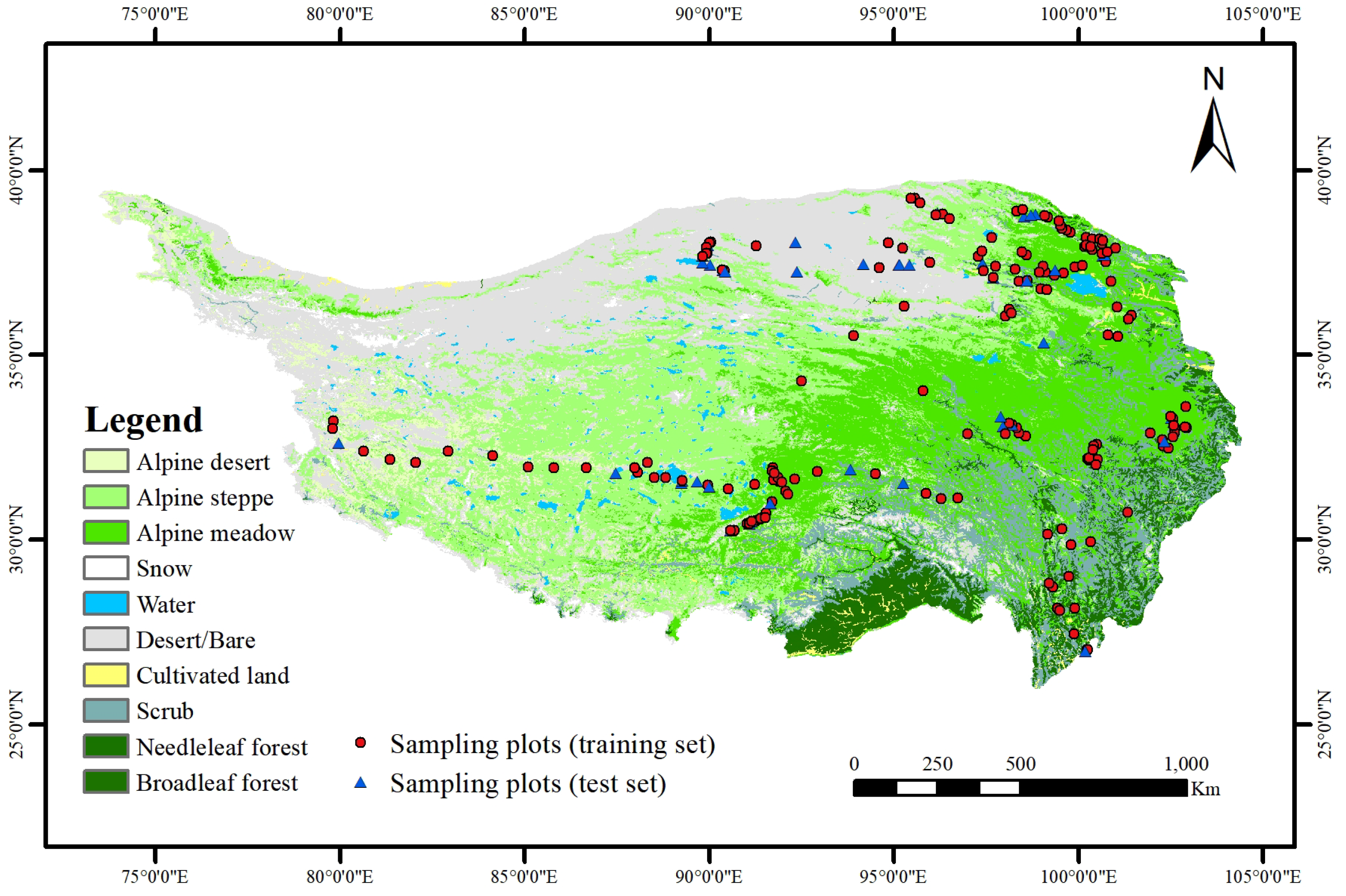
2.1. Study Area
2.2. Field Data
2.3. Elevation Dataset
2.4. Meteorological Data
2.5. S2 Bands and S2-Derived VIs
3. Methodology
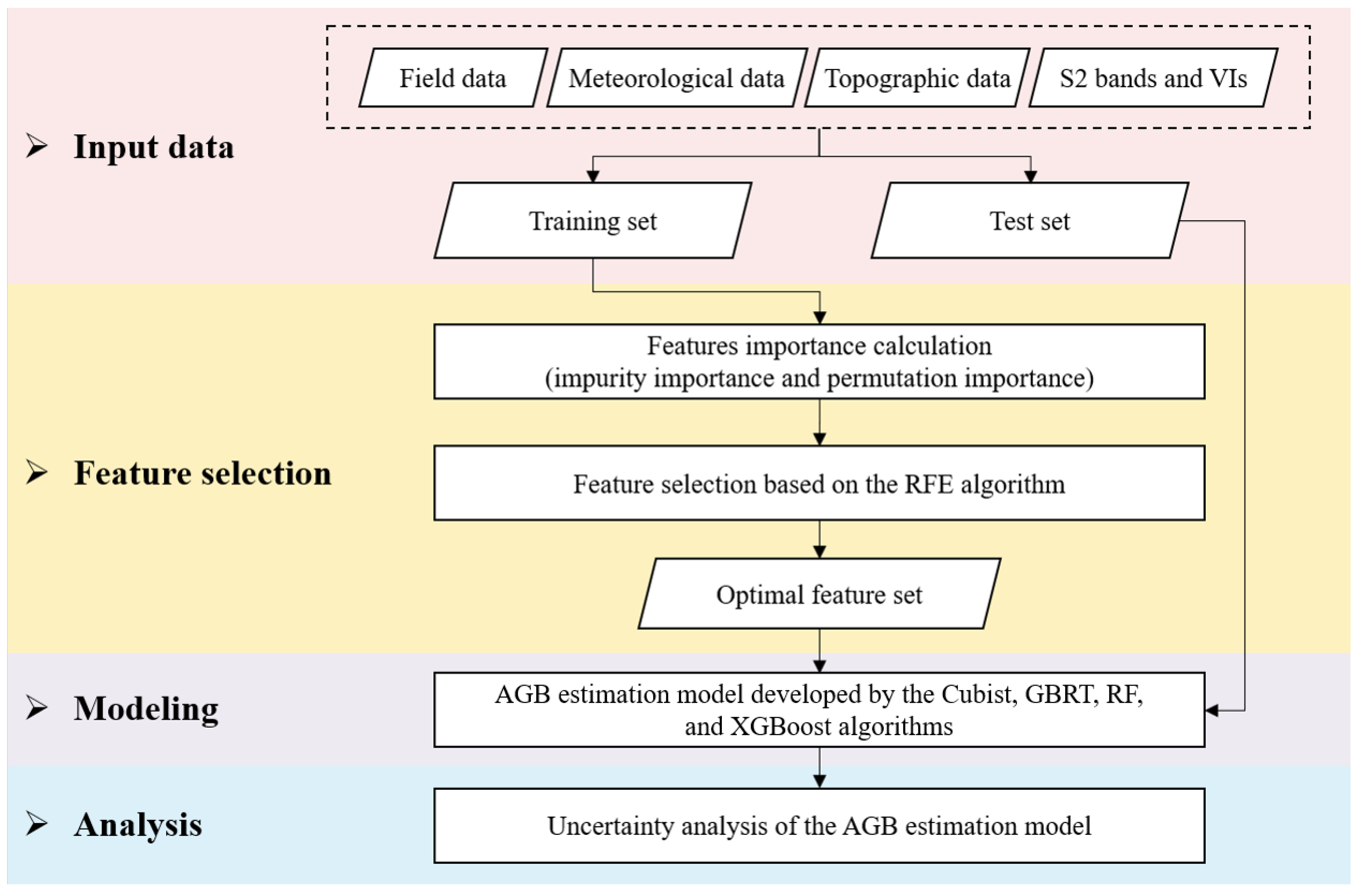
3.1. AGB Estimation Procedure
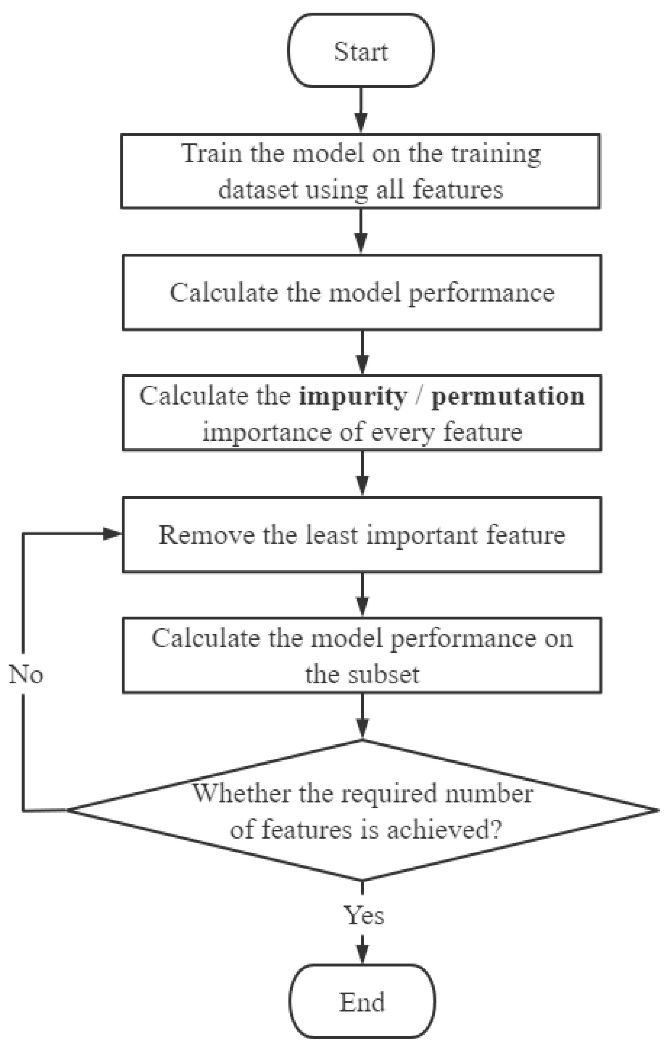
3.2. Recursive Feature Elimination
3.3. Feature Importance
3.4. Cubist
3.5. GBRT
3.6. RF
3.7. XGBoost
3.8. Estimation Accuracy Evaluation
4. Results and Discussion
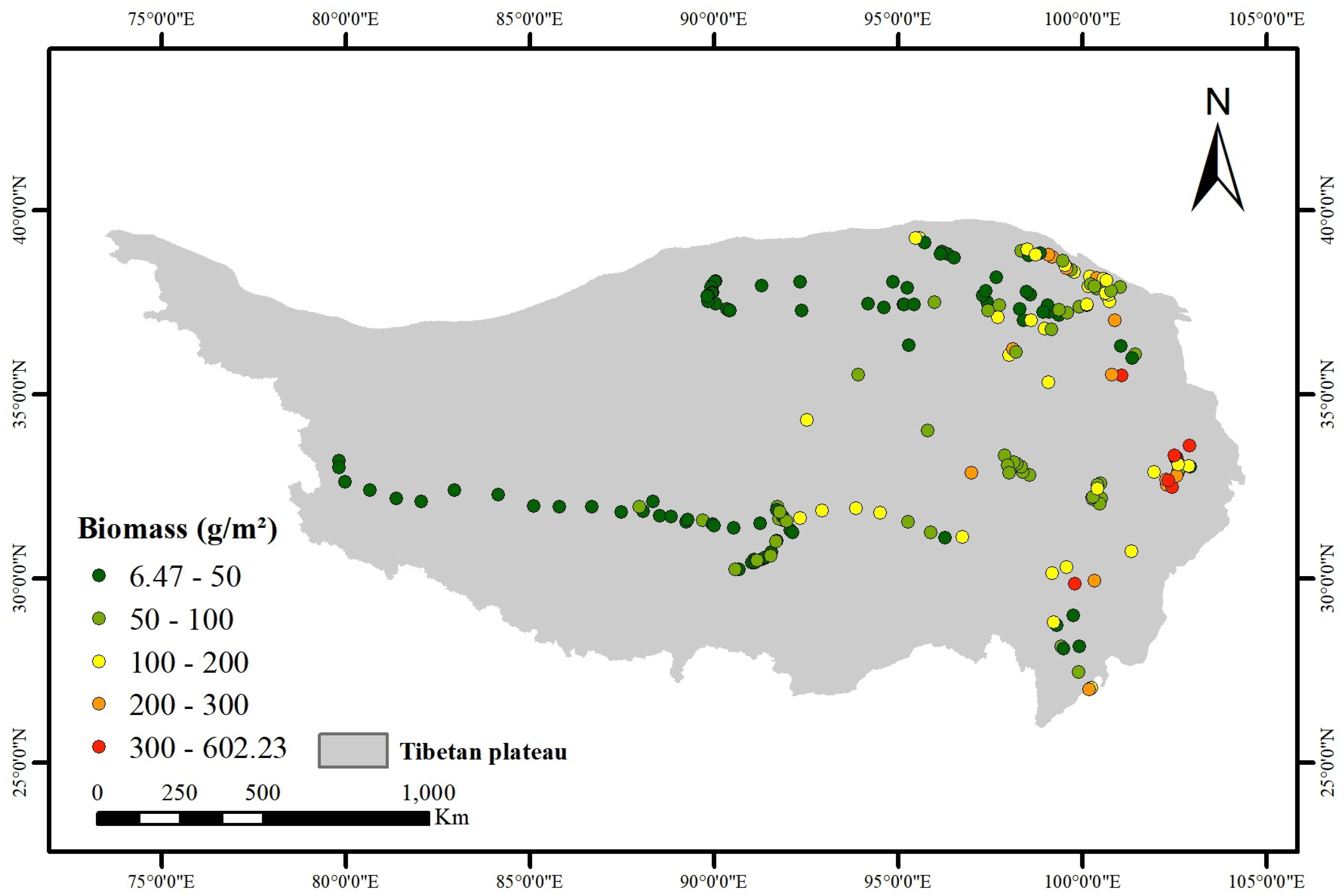
4.1. Spatial Distribution Grassland AGB from All the Sampling Plots
4.2. Feature Importance
4.3. Performance of Feature Selection
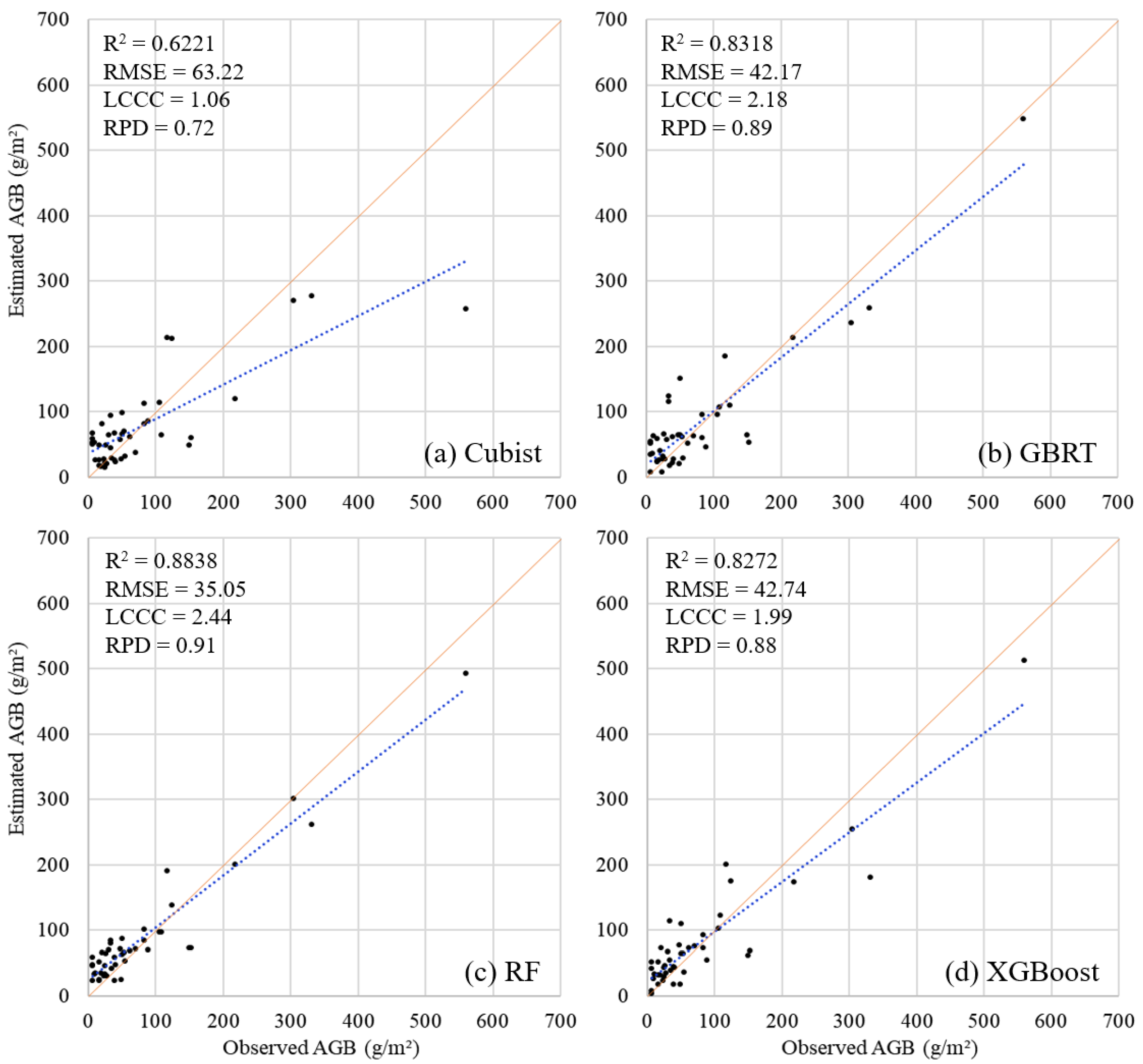
4.4. Evaluation of AGB Models
4.5. Advantages of S2 Images and S2-Derived VIs in Estimating Grassland AGB
4.6. Influence of Features on Grassland AGB
4.7. Limitations and Future Works
5. Conclusions
Author Contributions
Funding
Data Availability Statement
Acknowledgments
Conflicts of Interest
References
- Nie, X.-Q.; Yang, L.-C.; Xiong, F.; Li, C.-B.; Fan, L.; Zhou, G.-Y. Aboveground biomass of the alpine shrub ecosystems in three-river source region of the tibetan plateau. J. Mt. Sci. 2018, 15, 57–363. [Google Scholar] [CrossRef]
- John, R.; Chen, J.; Giannico, V.; Park, H.; Xiao, J.; Shirkey, G.; Ouyang, Z.; Shao, C.; Lafortezza, R.; Qi, J. Grassland canopy cover and aboveground biomass in mongolia and inner mongolia: Spatiotemporal estimates and controlling factors. Remote Sens. Environ. 2018, 213, 34–48. [Google Scholar] [CrossRef]
- Xia, J.; Ma, M.; Liang, T.; Wu, C.; Yang, Y.; Zhang, L.; Zhang, Y.; Yuan, W. Estimates of grassland biomass and turnover time on the tibetan plateau. Environ. Res. Lett. 2018, 13, 014020. [Google Scholar] [CrossRef]
- Liu, S.; Cheng, F.; Dong, S.; Zhao, H.; Hou, X.; Wu, X. Spatiotemporal dynamics of grassland aboveground biomass on the qinghai-tibet plateau based on validated modis ndvi. Sci. Rep. 2017, 7, 4182. [Google Scholar] [CrossRef] [PubMed]
- Zeng, N.; Ren, X.; He, H.; Zhang, L.; Zhao, D.; Ge, R.; Li, P.; Niu, Z. Estimating grassland aboveground biomass on the tibetan plateau using a random forest algorithm. Ecol. Indic. 2019, 102, 479–487. [Google Scholar] [CrossRef]
- Gao, X.; Dong, S.; Li, S.; Xu, Y.; Liu, S.; Zhao, H.; Yeomans, J.; Li, Y.; Shen, H.; Wu, S.; et al. Using the random forest model and validated modis with the field spectrometer measurement promote the accuracy of estimating aboveground biomass and coverage of alpine grasslands on the qinghai-tibetan plateau. Ecol. Indic. 2020, 112, 106114. [Google Scholar] [CrossRef]
- Punalekar, S.M.; Verhoef, A.; Quaife, T.; Humphries, D.; Bermingham, L.; Reynolds, C. Application of sentinel-2a data for pasture biomass monitoring using a physically based radiative transfer model. Remote Sens. Environ. 2018, 218, 207–220. [Google Scholar] [CrossRef]
- Forkuor, G.; Zoungrana, J.-B.B.; Dimobe, K.; Ouattara, B.; Vadrevu, K.P.; Tondoh, J.E. Above-ground biomass mapping in west african dryland forest using sentinel-1 and 2 datasets-a case study. Remote Sens. Environ. 2020, 236, 111496. [Google Scholar] [CrossRef]
- Zhang, Y.; Shao, Z. Assessing of urban vegetation biomass in combination with lidar and high-resolution remote sensing images. Int. J. Remote Sens. 2021, 42, 964–985. [Google Scholar] [CrossRef]
- Lu, D. Aboveground biomass estimation using landsat tm data in the brazilian amazon. Int. J. Remote Sens. 2005, 26, 2509–2525. [Google Scholar] [CrossRef]
- Yu, K.; Wu, X.; Ding, W.; Pei, J. Scalable and accurate online feature selection for big data. ACM Trans. Knowl. Discov. Data (TKDD) 2016, 11, 1–39. [Google Scholar] [CrossRef]
- Li, J.; Cheng, K.; Wang, S.; Morstatter, F.; Trevino, R.P.; Tang, J.; Liu, H. Feature selection: A data perspective. ACM Comput. Surv. (CSUR) 2017, 50, 1–45. [Google Scholar] [CrossRef]
- Meyer, H.; Lehnert, L.W.; Wang, Y.; Reudenbach, C.; Nauss, T.; Bendix, J. From local spectral measurements to maps of vegetation cover and biomass on the qinghai-tibet-plateau: Do we need hyperspectral information? Int. J. Appl. Earth Obs. Geoinf. 2017, 55, 21–31. [Google Scholar] [CrossRef]
- Misra, P.; Yadav, A.S. Improving the classification accuracy using recursive feature elimination with cross-validation. Int. J. Emerg. Technol. 2020, 11, 659–665. [Google Scholar]
- Yin, J.; Feng, Q.; Liang, T.; Meng, B.; Yang, S.; Gao, J.; Ge, J.; Hou, M.; Liu, J.; Wang, W.; et al. Estimation of grassland height based on the random forest algorithm and remote sensing in the tibetan plateau. IEEE J. Sel. Top. Appl. Earth Obs. Remote Sens. 2019, 13, 178–186. [Google Scholar] [CrossRef]
- Haq, M.A. Planetscope nanosatellites image classification using machine learning. Comput. Syst. Sci. Eng. 2022, 42, 1031–1046. [Google Scholar]
- Wang, X.; Zhang, J.; Xun, L.; Wang, J.; Wu, Z.; Henchiri, M.; Zhang, S.; Zhang, S.; Bai, Y.; Yang, S.; et al. Evaluating the effectiveness of machine learning and deep learning models combined time-series satellite data for multiple crop types classification over a large-scale region. Remote Sens. 2022, 14, 2341. [Google Scholar] [CrossRef]
- Pelta, R.; Beeri, O.; Tarshish, R.; Shilo, T. Sentinel-1 to ndvi for agricultural fields using hyperlocal dynamic machine learning approach. Remote Sens. 2022, 14, 2600. [Google Scholar] [CrossRef]
- Zhao, D.; Arshad, M.; Wang, J.; Triantafilis, J. Soil exchangeable cations estimation using vis-nir spectroscopy in different depths: Effects of multiple calibration models and spiking. Comput. Electron. Agric. 2021, 182, 105990. [Google Scholar] [CrossRef]
- Zhao, D.; Wang, J.; Zhao, X.; Triantafilis, J. Clay content mapping and uncertainty estimation using weighted model averaging. Catena 2022, 209, 105791. [Google Scholar] [CrossRef]
- Yu, R.; Yao, Y.; Wang, Q.; Wan, H.; Xie, Z.; Tang, W.; Zhang, Z.; Yang, J.; Shang, K.; Guo, X.; et al. Satellite-derived estimation of grassland aboveground biomass in the three-river headwaters region of china during 1982–2018. Remote Sens. 2021, 13, 2993. [Google Scholar] [CrossRef]
- Tang, Y.; Wan, S.; He, J.; Zhao, X. Foreword to the special issue: Looking into the impacts of global warming from the roof of the world. J. Plant Ecol. 2009, 2, 169–171. [Google Scholar] [CrossRef]
- You, Y.; Wang, S.; Pan, N.; Ma, Y.; Liu, W. Growth stage-dependent responses of carbon fixation process of alpine grasslands to climate change over the tibetan plateau, china. Agric. For. Meteorol. 2020, 291, 108085. [Google Scholar] [CrossRef]
- Ding, M.; Zhang, Y.; Sun, X.; Liu, L.; Wang, Z.; Bai, W. Spatiotemporal variation in alpine grassland phenology in the qinghai-tibetan plateau from 1999 to 2009. Chin. Sci. Bull. 2013, 58, 396–405. [Google Scholar] [CrossRef]
- Ding, M. Temperature and Precipitation Grid Data of the Qinghai Tibet Plateau and Its Surrounding Areas in 1998–2017. Grid Data of Annual Temperature and Annual Precipitation on the Tibetan Plateau and Its Surrounding Areas during 1998–2017. Available online: https://data.tpdc.ac.cn/en/data/c954daad-6086-4edd-a6c5-f69c581e5c31/ (accessed on 14 September 2022).
- Wang, C.; Guo, H.; Zhang, L.; Qiu, Y.; Sun, Z.; Liao, J.; Liu, G.; Zhang, Y. Improved alpine grassland mapping in the tibetan plateau with modis time series: A phenology perspective. Int. J. Digit. Earth 2015, 8, 133–152. [Google Scholar] [CrossRef]
- Wang, C.; Guo, H.; Zhang, L.; Qiu, Y.; Sun, Z.; Liao, J.; Liu, G.; Zhang, Y. Alpine Grassland Map. Science Data Bank. 2017. Available online: https://www.scidb.cn/en/detail?dataSetId=633694460949037059 (accessed on 14 September 2022).
- Liang, T.; Yang, S.; Feng, Q.; Liu, B.; Zhang, R.; Huang, X.; Xie, H. Multi-factor modeling of above-ground biomass in alpine grassland: A case study in the three-river headwaters region, china. Remote Sens. Environ. 2016, 186, 164–172. [Google Scholar] [CrossRef]
- Yan, F.; Wu, B.; Wang, Y. Estimating aboveground biomass in mu us sandy land using landsat spectral derived vegetation indices over the past 30 years. J. Arid Land 2013, 5, 521–530. [Google Scholar] [CrossRef]
- Wang, G.; Liu, S.; Liu, T.; Fu, Z.; Yu, J.; Xue, B. Modelling above-ground biomass based on vegetation indexes: A modified approach for biomass estimation in semi-arid grasslands. Int. J. Remote Sens. 2019, 40, 3835–3854. [Google Scholar] [CrossRef]
- Liu, H.Q.; Huete, A. A feedback based modification of the ndvi to minimize canopy background and atmospheric noise. IEEE Trans. Geosci. Remote Sens. 1995, 33, 457–465. [Google Scholar] [CrossRef]
- Shen, M.; Tang, Y.; Klein, J.; Zhang, P.; Gu, S.; Shimono, A.; Chen, J. Estimation of aboveground biomass using in situ hyperspectral measurements in five major grassland ecosystems on the tibetan plateau. J. Plant Ecol. 2008, 1, 247–257. [Google Scholar] [CrossRef]
- Qi, J.; Chehbouni, A.; Huete, A.R.; Kerr, Y.H.; Sorooshian, S. A modified soil adjusted vegetation index. Remote Sens. Environ. 1994, 48, 119–126. [Google Scholar] [CrossRef]
- Chen, J.M. Evaluation of vegetation indices and a modified simple ratio for boreal applications. Can. J. Remote Sens. 1996, 22, 229–242. [Google Scholar] [CrossRef]
- Sriwongsitanon, N.; Gao, H.; Savenije, H.; Maekan, E.; Saengsawan, S.; Thianpopirug, S. The normalized difference infrared index (ndii) as a proxy for soil moisture storage in hydrological modelling. Hydrol. Earth Syst. Sci. Discuss. 2015, 12, 8419–8457. [Google Scholar]
- Xu, D.; Wang, C.; Chen, J.; Shen, M.; Shen, B.; Yan, R.; Li, Z.; Karnieli, A.; Chen, J.; Yan, Y.; et al. The superiority of the normalized difference phenology index (ndpi) for estimating grassland aboveground fresh biomass. Remote Sens. Environ. 2021, 264, 112578. [Google Scholar] [CrossRef]
- Gamon, J.A.; Field, C.B.; Goulden, M.L.; Griffin, K.L.; Hartley, A.E.; Joel, G.; Penuelas, J.; Valentini, R. Relationships between NDVI, canopy structure, and photosynthesis in three Californian vegetation types. Ecol. Appl. 1995, 5, 28–41. [Google Scholar] [CrossRef]
- Tucker, C.J. Red and photographic infrared linear combinations for monitoring vegetation. Remote Sens. Environ. 1979, 8, 127–150. [Google Scholar] [CrossRef]
- Rondeaux, G.; Steven, M.; Baret, F. Optimization of soil-adjusted vegetation indices. Remote Sens. Environ. 1996, 55, 95–107. [Google Scholar] [CrossRef]
- Ren, H.; Zhou, G.; Zhang, F. Using negative soil adjustment factor in soil-adjusted vegetation index (savi) for aboveground living biomass estimation in arid grasslands. Remote Sens. Environ. 2018, 209, 439–445. [Google Scholar] [CrossRef]
- Jordan, C.F. Derivation of leaf-area index from quality of light on the forest floor. Ecology 1969, 50, 663–666. [Google Scholar] [CrossRef]
- Huete, A.R. A soil-adjusted vegetation index (savi). Remote Sens. Environ. 1988, 25, 295–309. [Google Scholar] [CrossRef]
- Fu, G.; Shen, Z.X. Environmental humidity regulates effects of experimental warming on vegetation index and biomass production in an alpine meadow of the northern tibet. PLoS ONE 2016, 11, e0165643. [Google Scholar] [CrossRef]
- Nembrini, S.; König, I.R.; Wright, M.N. The revival of the gini importance? Bioinformatics 2018, 34, 3711–3718. [Google Scholar] [CrossRef] [PubMed]
- Boulesteix, A.-L.; Bender, A.; Bermejo, J.L.; Strobl, C. Random forest gini importance favours snps with large minor allele frequency: Impact, sources and recommendations. Briefings Bioinform. 2012, 13, 292–304. [Google Scholar] [CrossRef] [PubMed]
- Altmann, A.; Toloşi, L.; Sander, O.; Lengauer, T. Permutation importance: A corrected feature importance measure. Bioinformatics 2010, 26, 1340–1347. [Google Scholar] [CrossRef] [PubMed]
- Huang, N.; Lu, G.; Xu, D. A permutation importance-based feature selection method for short-term electricity load forecasting using random forest. Energies 2016, 9, 767. [Google Scholar] [CrossRef]
- Quinlan, R. C4.5: Programs for Machine Learning Morgan Kaufmann; Kluwer Academic Publishers: San Francisco, CA, USA, 1993. [Google Scholar]
- Friedman, J.H. Greedy function approximation: A gradient boosting machine. Ann. Stat. 2001, 29, 1189–1232. [Google Scholar] [CrossRef]
- Breiman, L. Random forests. Mach. Learn. 2001, 45, 5–32. [Google Scholar] [CrossRef]
- Haq, M.A. Smotednn: A novel model for air pollution forecasting and aqi classification. Comput. Mater. Contin. 2022, 71, 1. [Google Scholar]
- Haq, M.A. Cdlstm: A novel model for climate change forecasting. Comput. Mater. Contin. 2022, 71, 2363–2381. [Google Scholar]
- Friedman, J.H. Stochastic gradient boosting. Comput. Stat. Data Anal. 2002, 38, 367–378. [Google Scholar] [CrossRef]
- Rossel, R.V.; Behrens, T.; Ben-Dor, E.; Brown, D.; Demattê, J.; Shepherd, K.D.; Shi, Z.; Stenberg, B.; Stevens, A.; Adamchuk, V.; et al. A global spectral library to characterize the world’s soil. Earth-Sci. Rev. 2016, 155, 198–230. [Google Scholar] [CrossRef]
- Rossel, R.V.; McGlynn, R.; McBratney, A. Determining the composition of mineral-organic mixes using uv–vis–nir diffuse reflectance spectroscopy. Geoderma 2006, 137, 70–82. [Google Scholar] [CrossRef]
- Alley, W.M. The palmer drought severity index: Limitations and assumptions. J. Appl. Meteorol. Climatol. 1984, 23, 1100–1109. [Google Scholar] [CrossRef]
- Zeng, N.; Ren, X.; He, H.; Zhang, L.; Li, P.; Niu, Z. Estimating the grassland aboveground biomass in the three-river headwater region of china using machine learning and bayesian model averaging. Environ. Res. Lett. 2021, 16, 114020. [Google Scholar] [CrossRef]
- You, Y.; Wang, S.; Ma, Y.; Wang, X.; Liu, W. Improved modeling of gross primary productivity of alpine grasslands on the tibetan plateau using the biome-bgc model. Remote Sens. 2019, 11, 1287. [Google Scholar] [CrossRef]


| Sentinel-2 Bands | Central Wavelength (µm) | Resolution (m) | Wavelength S2A/S2B (nm) |
|---|---|---|---|
| B2—Blue | 0.490 | 10 | 496.6/492.1 |
| B3—Green | 0.560 | 10 | 560/559 |
| B4—Red | 0.665 | 10 | 664.5/665 |
| B5—Red Edge 1 | 0.705 | 20 | 703.9/703.8 |
| B6—Red Edge 2 | 0.740 | 20 | 740.2/739.1 |
| B7—Red Edge 3 | 0.783 | 20 | 782.5/779.7 |
| B8—NIR | 0.842 | 10 | 835.1/833 |
| B8A—Narrow NIR | 0.865 | 20 | 864.8/864 |
| B11—SWIR 1 | 1.610 | 20 | 1613.7/1610.4 |
| B12—SWIR 2 | 2.190 | 20 | 2202.4/2185.7 |
Publisher’s Note: MDPI stays neutral with regard to jurisdictional claims in published maps and institutional affiliations. |
© 2022 by the authors. Licensee MDPI, Basel, Switzerland. This article is an open access article distributed under the terms and conditions of the Creative Commons Attribution (CC BY) license (https://creativecommons.org/licenses/by/4.0/).
Share and Cite
Fan, X.; He, G.; Zhang, W.; Long, T.; Zhang, X.; Wang, G.; Sun, G.; Zhou, H.; Shang, Z.; Tian, D.; et al. Sentinel-2 Images Based Modeling of Grassland Above-Ground Biomass Using Random Forest Algorithm: A Case Study on the Tibetan Plateau. Remote Sens. 2022, 14, 5321. https://doi.org/10.3390/rs14215321
Fan X, He G, Zhang W, Long T, Zhang X, Wang G, Sun G, Zhou H, Shang Z, Tian D, et al. Sentinel-2 Images Based Modeling of Grassland Above-Ground Biomass Using Random Forest Algorithm: A Case Study on the Tibetan Plateau. Remote Sensing. 2022; 14(21):5321. https://doi.org/10.3390/rs14215321
Chicago/Turabian StyleFan, Xinyue, Guojin He, Wenyi Zhang, Tengfei Long, Xiaomei Zhang, Guizhou Wang, Geng Sun, Huakun Zhou, Zhanhuan Shang, Dashuan Tian, and et al. 2022. "Sentinel-2 Images Based Modeling of Grassland Above-Ground Biomass Using Random Forest Algorithm: A Case Study on the Tibetan Plateau" Remote Sensing 14, no. 21: 5321. https://doi.org/10.3390/rs14215321
APA StyleFan, X., He, G., Zhang, W., Long, T., Zhang, X., Wang, G., Sun, G., Zhou, H., Shang, Z., Tian, D., Li, X., & Song, X. (2022). Sentinel-2 Images Based Modeling of Grassland Above-Ground Biomass Using Random Forest Algorithm: A Case Study on the Tibetan Plateau. Remote Sensing, 14(21), 5321. https://doi.org/10.3390/rs14215321


