Abstract
Coal gangue is an inevitable product in coal mining and processing and is the most important source of pollution in mines. Vegetation restoration of coal gangue piles must consider its special site conditions. Therefore, we conducted unmanned air vehicle (UAV) temperature monitoring, field investigation and experimental analysis on spontaneous combustion coal gangue piles in Lu’an mining area. In the vegetation construction of coal gangue piles, high-temperature stress affects plant survival. The spontaneous combustion coal gangue piles have abnormal temperature, high surface temperature and few vegetation types. The plant community species diversity index (Shannon–Wiener index, Pielou’s index and Species abundance index) is small, the plant community is single and the plant diversity is low. Spontaneous combustion of coal gangue leads to soil acidification, reducing soil water content, soil organic carbon (SOM), available nitrogen (AN), available potassium (AK) and available phosphorus (AP). These factors are single or interactive in plants and have an impact on plant survival and growth. The research results are of great significance to the vegetation restoration of spontaneous combustion coal gangue piles, ecological reconstruction and the improvement of the ecological environment of coal mine areas.
1. Introduction
China is the biggest country of coal production and consumption, and coal mainly is used as power fuel and to generate electricity. Waste rocks are generated in the process of mine construction, coal mining and raw coal washing to form gangue piles. Gangue piles are severe problem in coal-producing countries. The stock of coal gangue in China alone has reached 4.5–5 Gt, with an average annual increase of 0.37–0.55 Gt [1]. The large accumulation of coal gangue occupies a large amount of land and causes serious environmental pollution. The spontaneous combustion of coal gangue emits harmful gases such as SO2, H2S, CO, CO2, and nitrogen oxides, accompanied by a large amount of smoke and dust. Coal gangue piles can also cause geological disasters such as collapse and mudslides. The leaching solution pollutes the surrounding soil and water, becoming the most serious source of pollution in the mining area, endangering the mining area’s ecological safety and human health [2]. Therefore, we need to carry out ecological restoration of coal gangue piles. The restoration of coal gangue pile vegetation needs to consider its special site conditions, among which ground temperature is one of the important restrictive factors [3]. Most gangue piles are naturally accumulated with loose structure, and iron sulfide content in gangue is high. A large amount of iron sulfide is oxidized and exothermal, which is easy to cause spontaneous combustion. When the stone coal spontaneous combustion tends to dramatic changes in surface temperature, soil conditions and plant growth [4].
Plant growth and development require certain temperature conditions. When the environmental temperature exceeds the range that they can adapt to, it will cause stress to plants. Temperature affects the productivity of plants and limits the distribution of plants [5]. If the temperature is too high, the root system of the plants will be damaged, and the plants will die. Studies have shown that when the soil temperature rises to a certain level, the growth rate of tree roots begins to decline or even stops completely. Root elongation rate was linearly related to changes in soil temperature and soil water potential [6]. The root water absorption rate increases with the increase of soil temperature within a certain range, but its water absorption will be inhibited when it exceeds a certain limit [7,8]. Temperature affects the life activities of plant roots: root growth slows down, absorption area decreases, cell protoplasm viscosity increases, fluidity slows, respiration weakens and energy supply is insufficient. As a result, the absorption and distribution of mineral elements in plants are restricted and affected [9]. Due to the low temperature in winter, the biodiversity of vegetation construction is reduced, the available resources are limited and some plants often die due to freezing damage [10]. Especially in winter, on spontaneous combustion coal gangue piles, plants are simultaneously stressed by high and low temperatures. The rhizosphere of plants is under high temperature stress, and the upper part of the ground is endangered by severe winter, disrupting the normal growth rhythm of plants. Coal gangue is stacked in the open air for a long time, and the heat inside the gangue gradually accumulates. When the temperature reaches the ignition point, the residual coal and other combustibles in the gangue can ignite spontaneously. The spontaneous combustion of coal gangue piles leads to an increase in soil acidity, which will inevitably affect the physical, chemical, biochemical and other properties of the soil, thereby affecting the growth of vegetation [11]. The spontaneous combustion of acidified coal gangue will inevitably lead to soil surface temperature rise, water evaporation and soil nutrient loss. Many studies have also shown that changes in soil temperature in arid and semi-arid regions have a particularly significant impact on soil water holding properties, and the maximum effective soil water content decreases with increasing temperature [12]. Soil moisture and nutrients are the basic conditions for plant survival and growth, and both are indispensable [13]. The spontaneous combustion of coal gangue piles causes the loss of soil moisture and nutrients, resulting in the deterioration of plant habitats, the destruction of plant living conditions and the formation of stress on plants in different ways.
The deep part of the gangue pile is in the burning stage, and thick smoke, high temperatures and even open flames will be generated on the surface of the gangue pile. Currently, it is too late to take measures. It is often difficult to monitor when the gangue pile is deep in the fever stage. There are many methods for monitoring the spontaneous combustion of gangue piles. Such as direct detection of temperature sensor or thermal infrared method to obtain the surface temperature of gangue pile. In the gangue pile in the heating stage, the internal temperature is transferred to the surroundings with the heat source as the center. When the heat is transferred to the surface soil layer, the surface vegetation will begin to be stressed. Nowadays, most reports focus on screening high temperature stress vegetation on coal gangue piles. Scholars’ research on the monitoring of the surface temperature of the waste rock does not involve the monitoring and early warning of the fever stage. There are no reports on the comprehensive analysis of the factors affecting the vegetation construction of spontaneous combustion coal gangue piles. Temperature is an important indicator for the safety of coal gangue piles, and it is also the main basis for predicting the location of the fire point of spontaneous combustion coal gangue piles and controlling the spontaneous combustion of coal gangue piles. With the rapid development of infrared measurement technology, unmanned air vehicle (UAV) monitoring technology has gradually been applied to the monitoring of the surface temperature field of coal gangue piles and extraction of ground fissures [14]. In this study, the surface temperature, vegetation coverage and soil nutrients of gangue piles with different degrees of spontaneous combustion are analyzed by using UAV, field investigation and laboratory analysis, to explore the influence of temperature of gangue piles with different degrees of spontaneous combustion on vegetation and soil. The findings of this study will provide a theoretical and technical basis for the ecological restoration of coal mining areas and early warning of spontaneous combustion of coal gangue.
2. Materials and Methods
2.1. Study Area
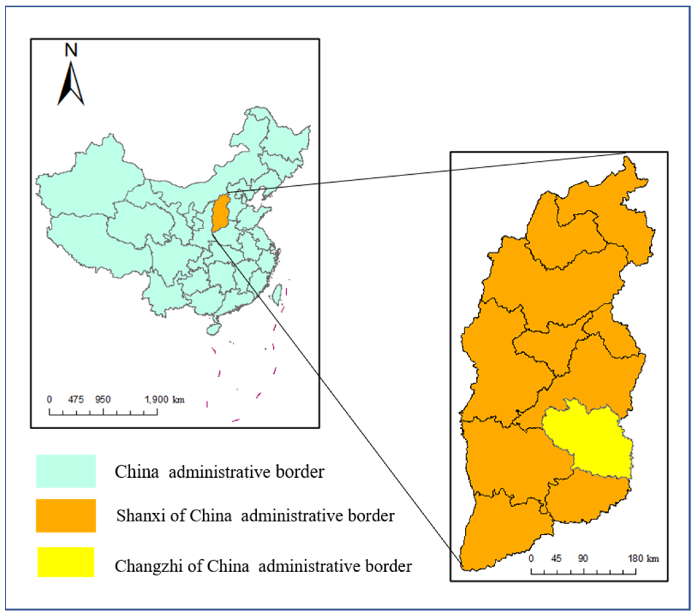
The research area is located in the coal district of Luan, Changzhi City, Shanxi Province (Figure 1), and its geographical coordinates are E 112°32′53″ to 113°16′35″, N 35°50′09″ to 36°33′49″. The terrain of the whole area is high in the northwest and low in the southeast, and generally slopes to the southeast. The study area belongs to the continental climate of plateau temperate plateau, with long winters and short summers and the same period of rain heat. The annual average temperature is 8–9 °C, the lowest average temperature in January is −6 to 9 °C, and the annual rainfall is 414–917 mm. There are three types of soil: brown soil, meadow soil and paddy soil, and the main vegetation is M. sativa, A. fruticosa L. and F. arundinacea.
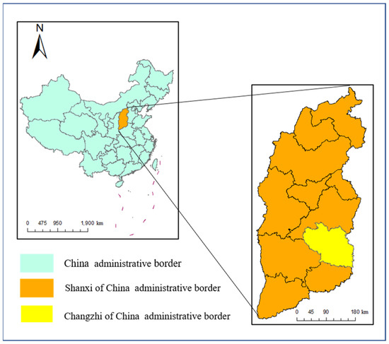
Figure 1.
Geographical location of Changzhi, Shanxi Province, China.
We have selected four different coal gangue piles for research, and the details are shown in Table 1. The gangue piles of Wuyang (WY) Mine were piled up in 1982. The gangue piles have spontaneous combustion and are currently locally heated. The gangue pile of Zhangcun (ZC) Mine was opened in 1979 and piled up on the ground. Spontaneous combustion has occurred in a large area. Wangzhuang Mine (WZ) currently has 3 gangue piles, the west gangue piles started comprehensive ecological management in 2008, and there is no sign of spontaneous combustion. As of August 2009, the Changcun coal gangue pile (CC) has completed the greening project of nearly 70,000 square meters in the whole mountain, and there is no sign of spontaneous combustion so far.

Table 1.
Four research gangue pile questionnaires.
2.2. Methods
2.2.1. UAV Monitoring
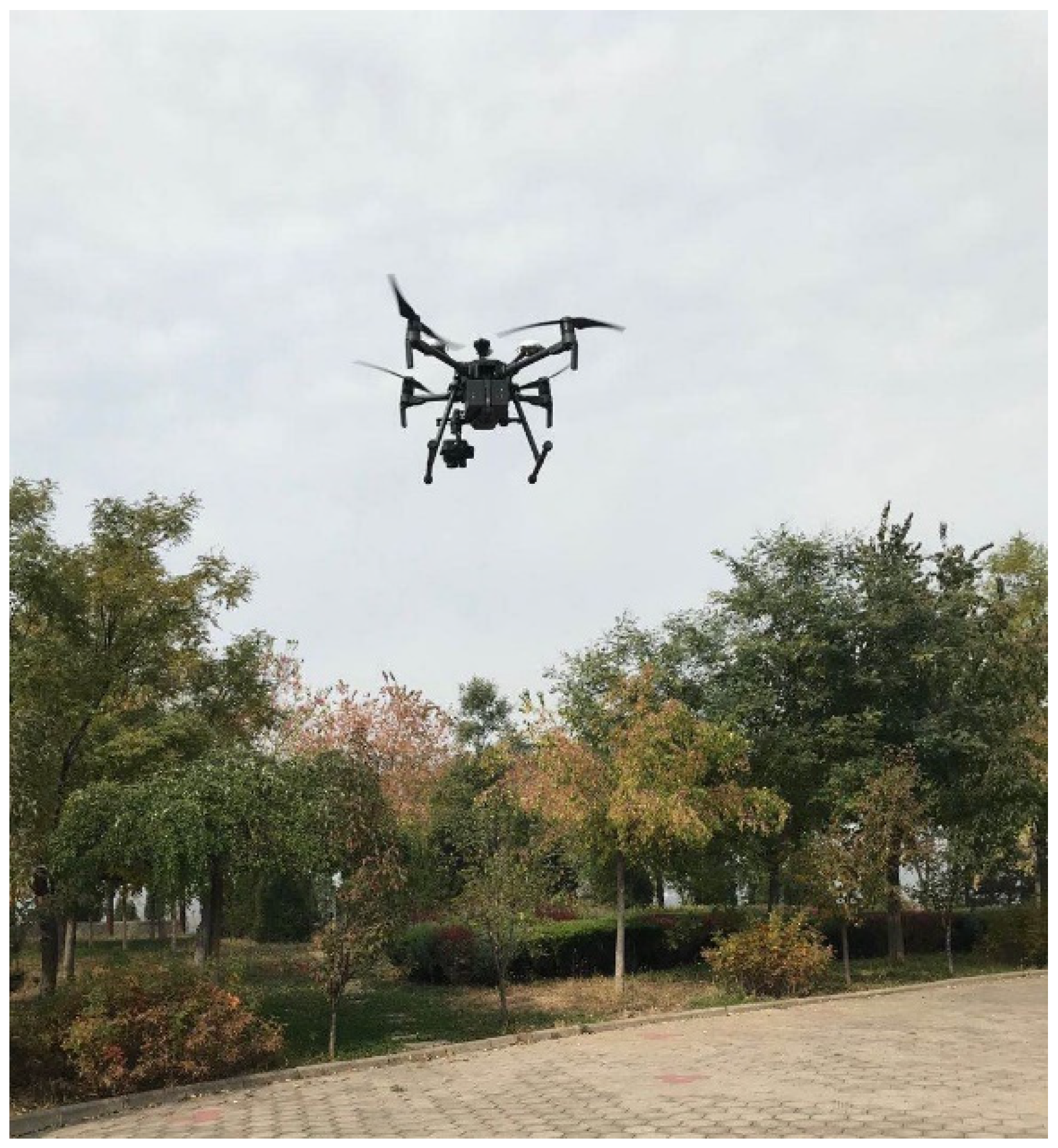
This test uses DJI Jingwei M210 RTK UAV as the flight platform. Its horizontal and vertical positioning accuracy reaches ±0.1 m, and the platform is equipped with an XT2 dual-light thermal imaging lens, which can simultaneously collect visible light images and thermal infrared images. The thermal imaging camera uses an uncooled vanadium oxide (VOx) micro-pyrometer as the thermal imager; the visible light camera uses 1/1.7” CMOS as the sensor, with an effective pixel of 12 million. The photo of the UAV is shown in Figure 2. When collecting the image data of the study area, an open area should be selected for the aircraft to take off and land; at the same time, the image data collection time should be carried out when the light conditions are better. When UAV data was collected, the wind speed was 1–2 m/s and the temperature was moderate. There was no rain in the study area one week before data collection. Before image collection, set the route parameters according to the test requirements. The course overlap degree and side overlap degree are set to 85%, the flying height is 120 m, the route speed is 5.0 m/s, the route flight time is about 75 min and the image spatial resolution is about 0.03 m. Data preprocessing of the data collected in the field mainly includes image stitching using Pix4D mapper and image cropping using ENVI5.3, and finally an orthophoto of the study area is obtained.
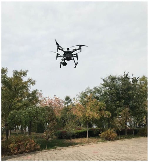
Figure 2.
Photos of UAV operation.
2.2.2. Vegetation Field Survey
This study selected four coal gangue piles for the vegetation field survey in October 2020. Adopt judgement sampling method in each area, select representative plots. Avoid low-lying, steep slopes and areas subject to strong human disturbance. Each plot set up 6 parallel plots, herb plots 1 m × 1 m, shrub plots size 2 m × 2 m, arbor plot size 5 m × 5 m (size adjusted according to vegetation pattern area), a total of 16 plots, 96 quadrats. The survey content of the plant community includes the name, number of plants, sub-coverage, above-ground biomass, and total coverage of the sample. Most plant species are identified on site, and unidentified species should be sampled for expert identification. The sampling followed a split plot experimental format with four different whole plots (CC, WZ, ZC and WY). In each plot, three quadrants (5 × 5 m per quadrat) were established as three soil cores. In each quadrant, five samples were randomly collected and mixed to form a composite soil sample at 0–15 cm. Overall, 15 core subsamples of each category (CC-1, CC-2, CC-3, CC-4, WZ-1, WZ-2, WZ-3, WZ-4, ZC-1, ZC-2, ZC-3, ZC-4 and WY-1, WY-2, WY-3, WY-4) were mixed to form one sample.
2.2.3. Analysis of the Properties of Soil Samples
Using a pH meter, soil pH was determined by water to soil ratio of 2.5:1. Soil moisture content was determined by weighing 10.0 g of fresh soil in each sample and placing it in an oven at 105° to constant weight. Use WSS type industrial bimetal thermometer to measure the actual surface temperature of coal gangue piles. The calculation method was as follows: soil moisture content = 1 − soil dry weight/soil fresh weight. The content of soil organic matter (SOM) was determined by potassium dichromate volumetric method [15]. The content of total nitrogen (TN) in soil was determined by Kjeldahl method [16]. Soil available nitrogen (AN) content was determined using a continuous flow analyzer. Soil available phosphorus (AP) was determined by molybdenum-antimony resistance colorimetric method. Soil available potassium (AK) was determined by atomic absorption spectrophotometer.
2.2.4. Data Analysis
Shannon–Wiener index, Pielou’s index and Species abundance index to measure the species diversity of the plant community. The raw data were collated with Excel 2016 and visualized with Origin 2017. SPSS 23.0 was applied for statistical analysis. The figures were produced with Origin 2017. PCA (principal component analysis) were used to determine the correlations between indicators among the samples using Canoco 5.0. Heat map and cluster analysis using Heml.
In the above equation, S is the number of species appearing in the quadrat, and Pi is the relative abundance of species.
3. Results
3.1. UAV Image Processing
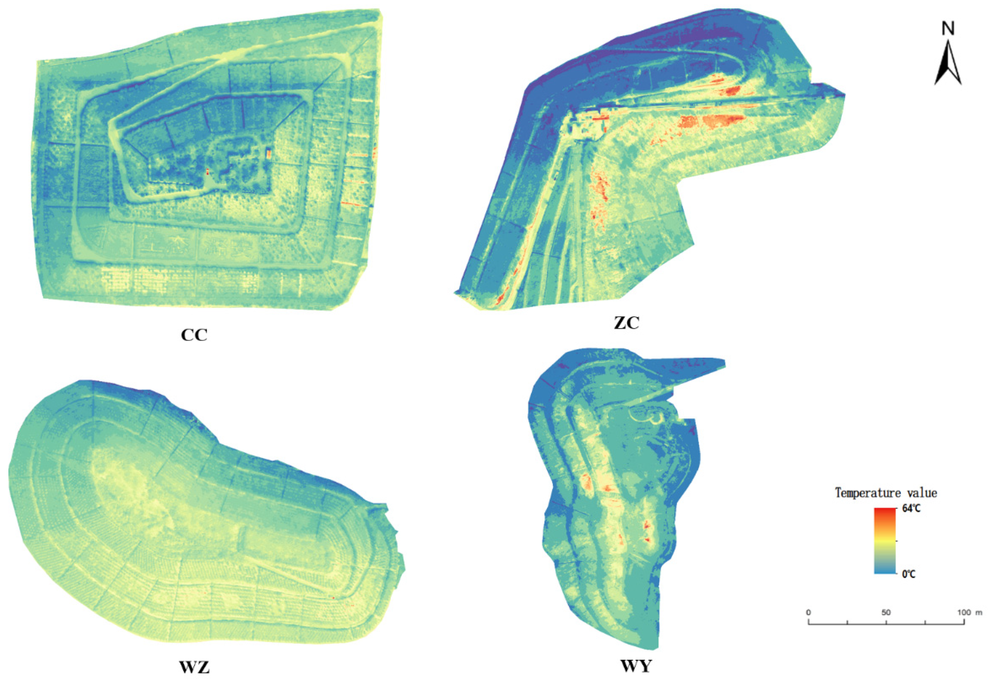
Extraction of temperature information from thermal infrared images of gangue piles. The four gangue piles were tested separately, and the vegetation in the study area basically reached full coverage. The images mainly include vegetation (grass-shrub-tree) and soil. In this study, the combined method of visible RGB image and thermal infrared image was used to obtain the surface temperature of the gangue pile. Use the Pix4D mapper software to stitch the images collected in the experiment to obtain the complete image of the study area, input the control points for image geometric correction, and use ENVI Classic to manually select the obvious landmark points in the visible light image and the thermal infrared image for image registration. Then, perform image resampling and image cropping to remove redundant parts. The temperature extracted from the thermal infrared image is calibrated by using a standard reflector (3 m × 3 m) with the same reflectivity in all directions and the ground surface temperature feature points. After the index calculation of vegetation information extracted from visible images, the vector file of vegetation information extracted was superposed in the thermal infrared image after registration, and the background value was removed through image mask processing to get the corresponding temperature of each pixel in the study area. Meanwhile, temperature statistics were carried out to get the abnormal area of surface temperature of gangue piles (Figure 3). The highest temperature of CC is 36.24°, the highest temperature of WZ is 37.21°, the highest temperature of ZC is 43.31° and the highest temperature of WY is 63.26°.
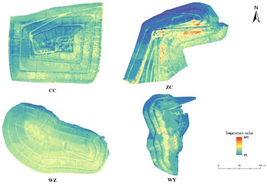
Figure 3.
Temperature distribution map of four coal gangue piles.
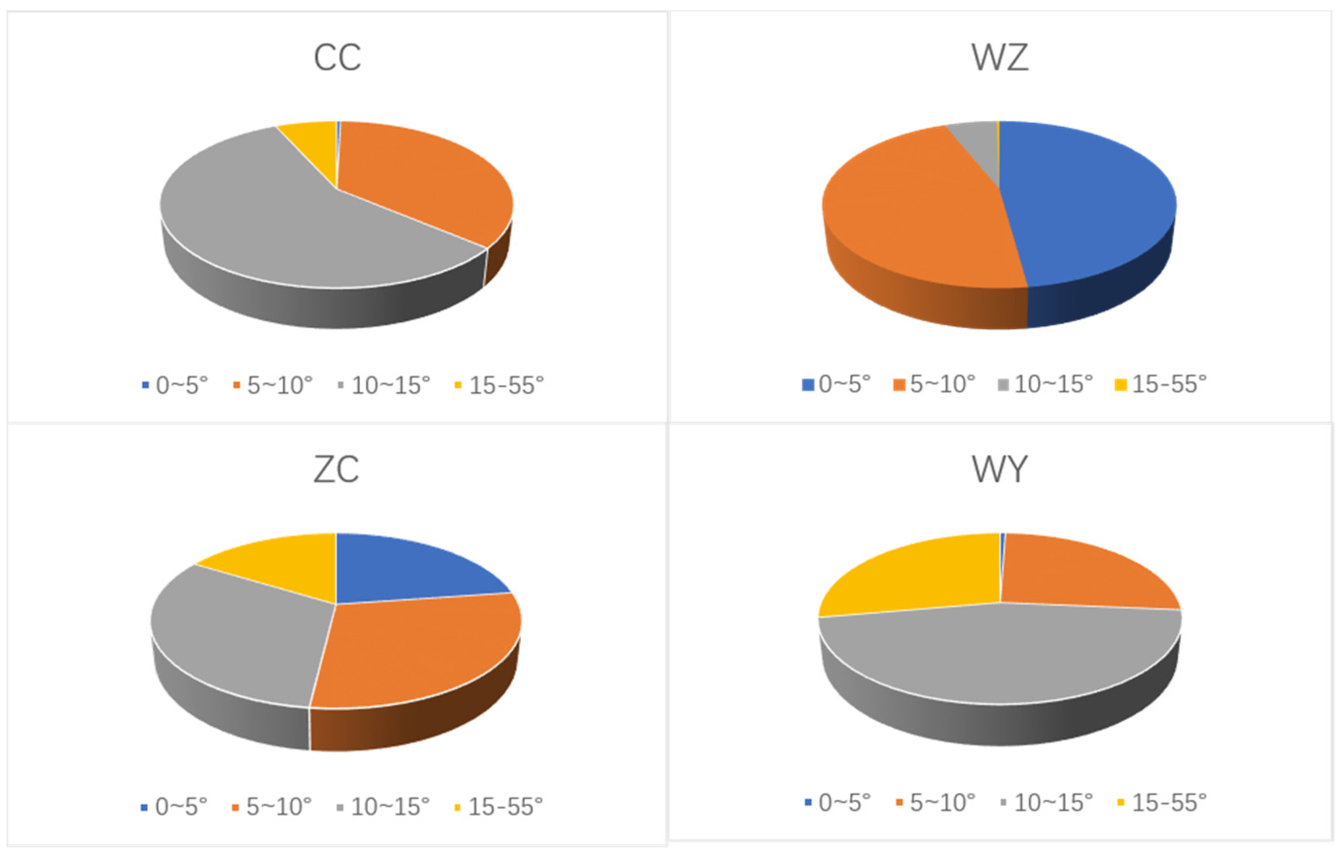
Divide the temperature of the four coal gangue piles into a pie chart, as shown in Figure 4. The temperature of CC is mostly concentrated at 10–15°, the temperature of WZ is mostly concentrated at 5–15°, the temperature of ZC is 15–55° accounting for 16.23%, the temperature of WY is between 15° and 55° and accounts for 27.79%. In general, the average temperature of coal gangue piles (ZC and WY) that have experienced spontaneous combustion is higher than that of gangue piles that have not experienced spontaneous combustion. The spontaneous combustion coal gangue pile (WY) is higher than that of the coal gangue pile (ZC) where spontaneous combustion has occurred.
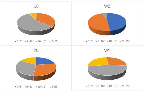
Figure 4.
Temperature pie chart of gangue piles.
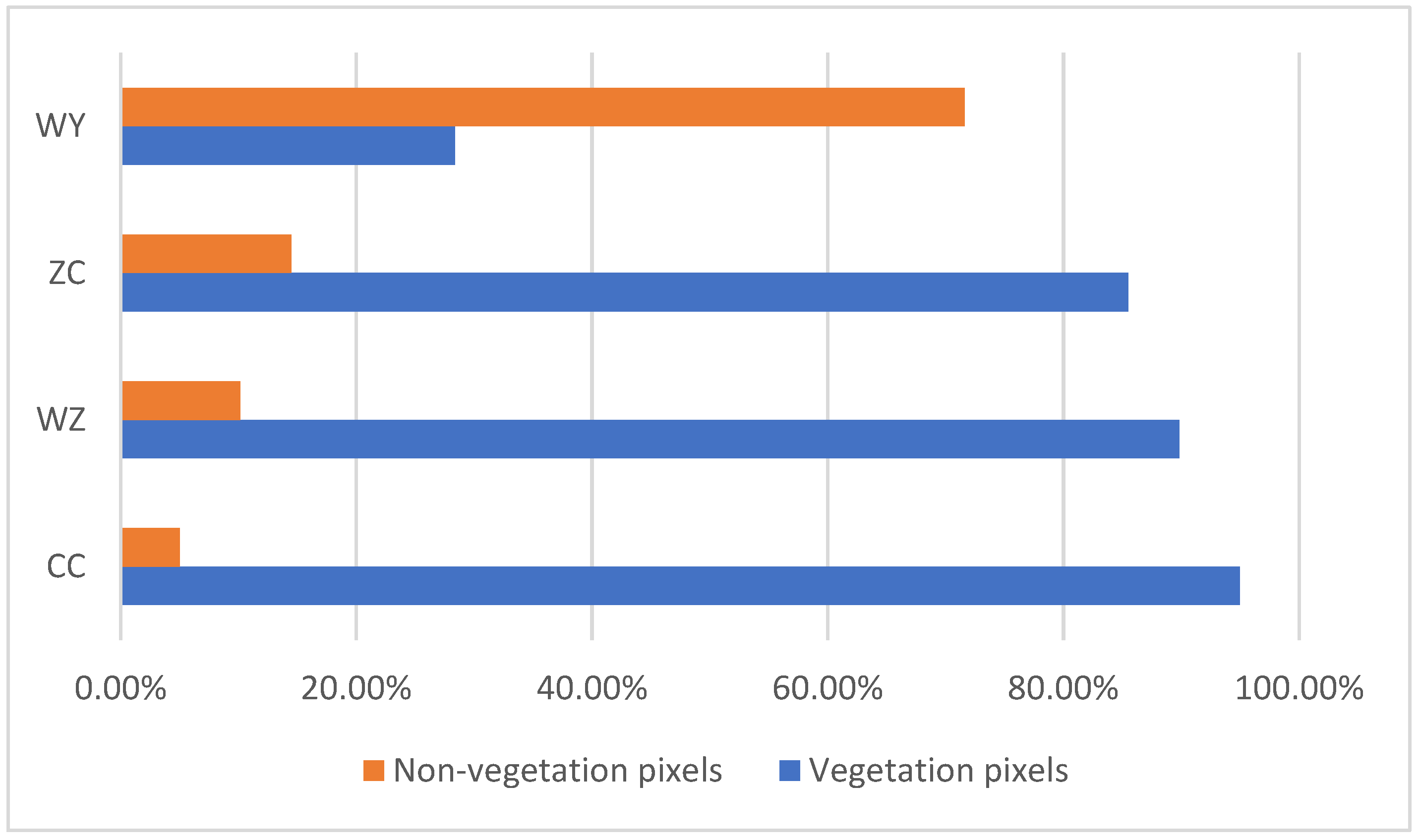
The visible light images of the drone are stitched to obtain vegetation pixel data (Figure 5). The image vegetation pixels of CC are 94.98%, the WZ image vegetation pixels are 89.83%, the ZC image vegetation pixels are 85.51%, and the WY vegetation pixels are 28.37%. There are more vegetation pixels in coal gangue piles without spontaneous combustion than coal gangue piles with spontaneous combustion.
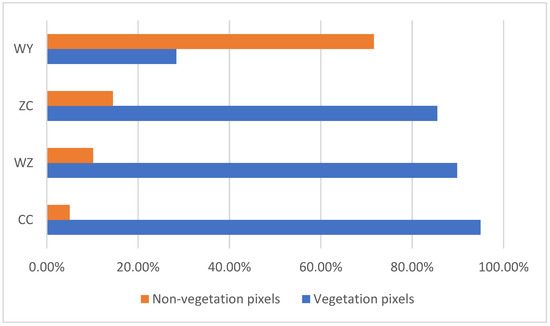
Figure 5.
The ratio of vegetation pixels in coal gangue piles.
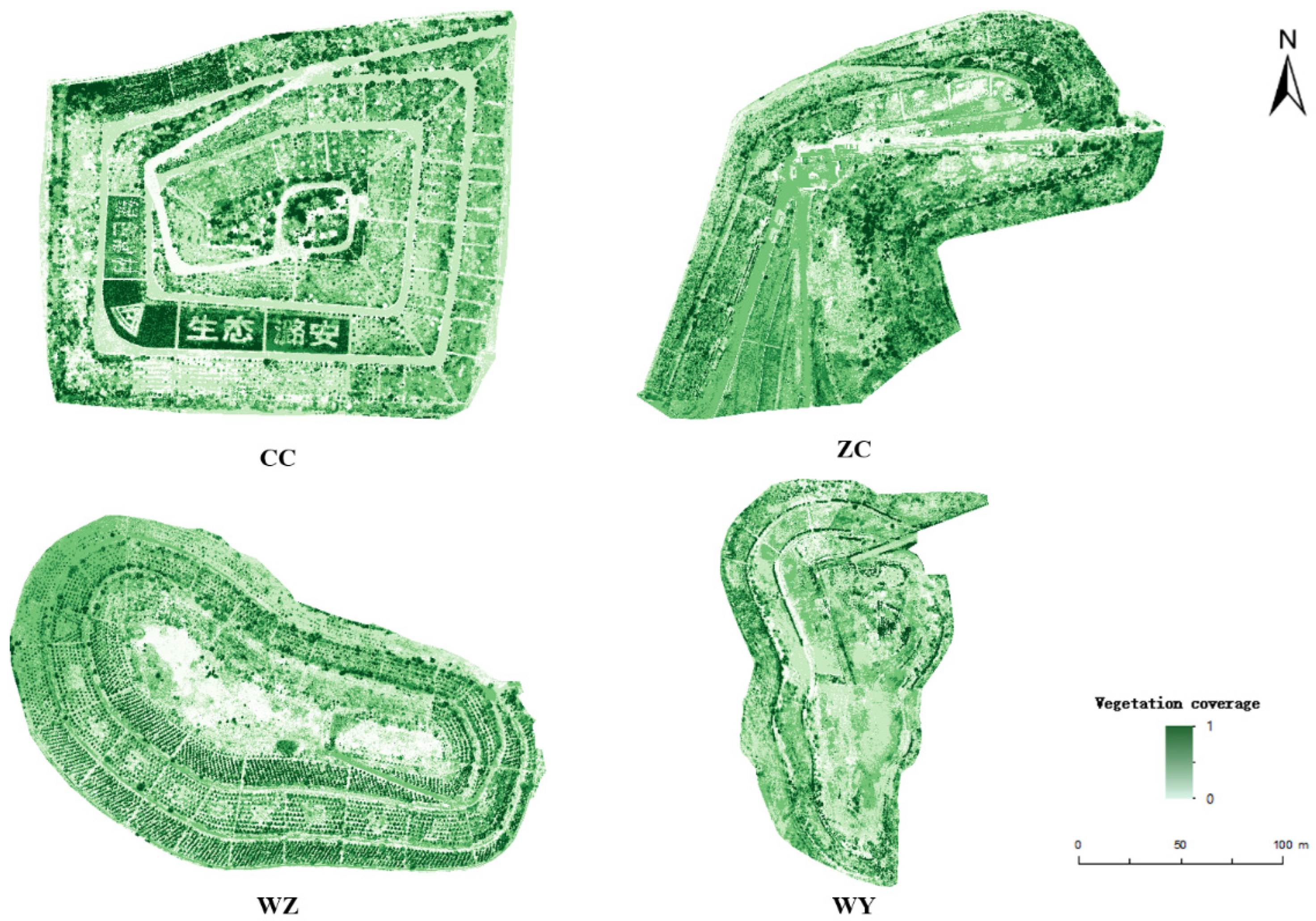
Make the image as a vegetation coverage map, see Figure 6. Among them, the average vegetation coverage of CC is 0.5109, the average vegetation coverage of WZ is 0.4608, the average vegetation coverage of ZC is 0.4399, and the average vegetation coverage of WY is 0.4382. The vegetation coverage of coal gangue piles with spontaneous combustion is lower than that of coal gangue piles without spontaneous combustion.
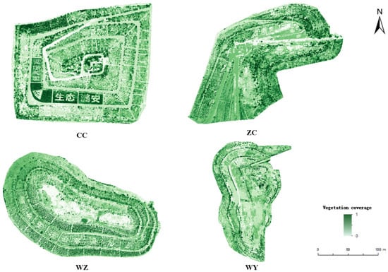
Figure 6.
Vegetation coverage map of coal gangue piles.
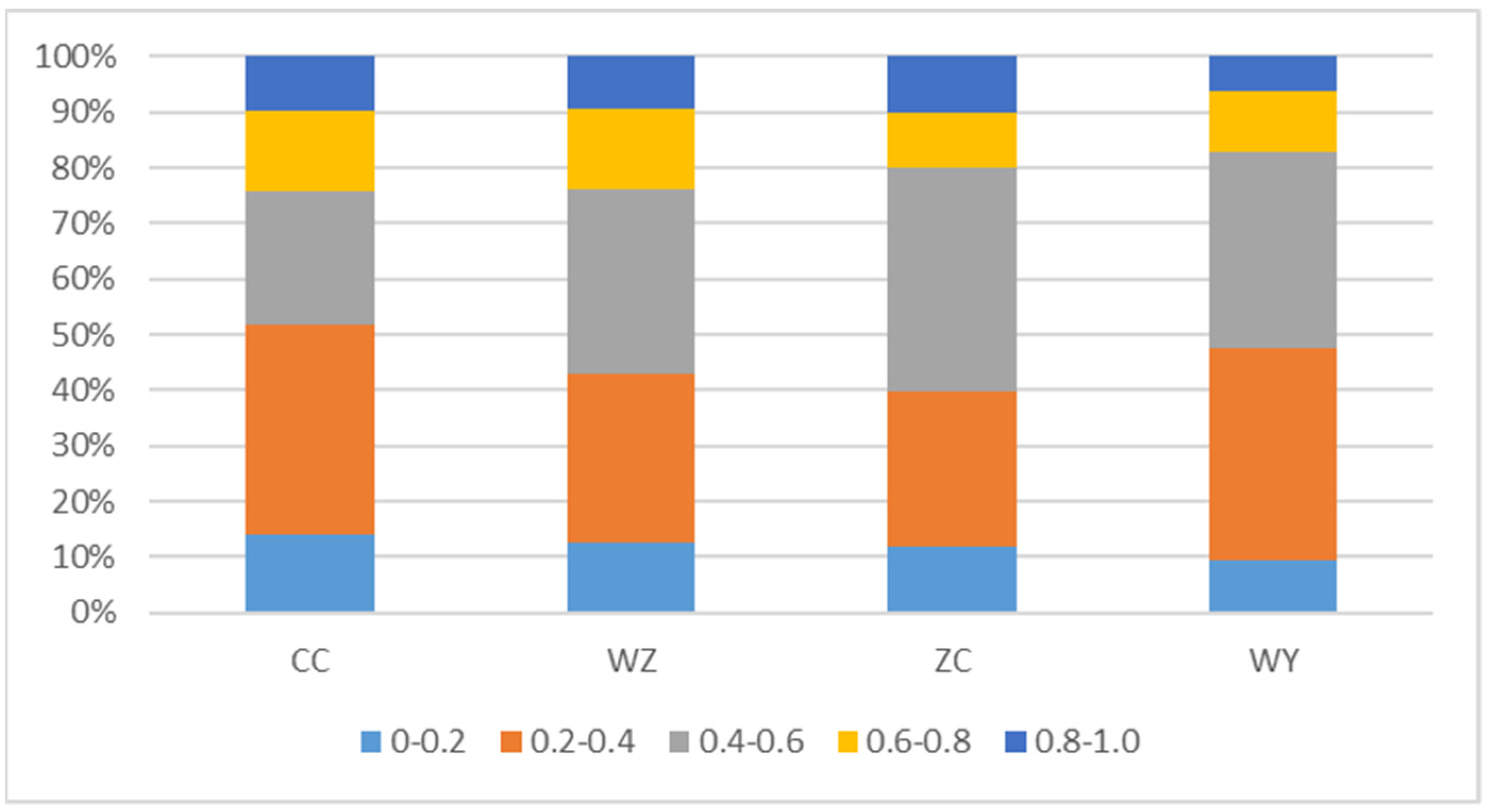
The vegetation coverage of the four gangue piles is made into a histogram, as shown in Figure 7. CC accounted for 24.13% of vegetation coverage between 0.6 and 1.0, WZ accounted for 23.9%, ZC accounted for 20.09% and WY accounted for 17.3%. At the same time, it also proved that unburned coal gangue piles have better vegetation coverage.
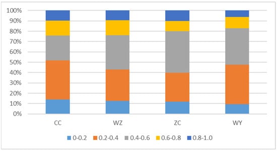
Figure 7.
Percentage of different vegetation coverage on coal gangue piles.
3.2. Field Investigation of Vegetation Status
By analyzing the community of plants, we studied the composition and vegetation types of this area. According to the relevant survey data and refer to relevant plant literature, the restored plants are divided into families and genera, as shown in Table 2. CC had 24 species of plants, belonging to 11 families and 21 genera; WZ has 17 species of plants, belonging to 9 families and 17 genera; WY has 15 species of plants, belonging to 7 families, and 13 genera; and ZC has 9 species of plants, belonging to 6 families and 9 genera. The dominant families of the flora are obvious, mainly including “A. fruticosa L.-F. arundinacea-M. sativa”, “Platycladus orientalis Franco-M. sativa” and “F. arundinacea-M. sativa” as the dominant species. The temperature of spontaneous combustion coal gangue piles is relatively high and there are fewer types of vegetation. The temperature of coal gangue piles that have never been spontaneously burned are normal and there are many types of vegetation. CC has a short restoration time and has more vegetation types than WZ. ZC used to have spontaneous combustion in a large area, and the natural restoration vegetation types are the least.

Table 2.
Vegetation diversity in the study area.
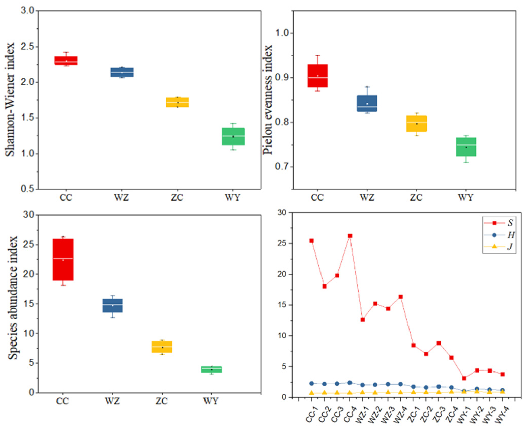
Integrate vegetation survey information such as the number of species, individuals, and distribution characteristics, and calculate the plant community species diversity index (Shannon-Wiener index H, Pielou’s index J and Species abundance index S). Figure 8 shows the species diversity characteristics of coal gangue piles with different degrees of spontaneous combustion. The Shannon–Wiener index H ranges from 1.05 to 2.42, with the highest point in CC and the lowest point in WY. The average CC, WZ, ZC and WY values are 2.31, 2.14, 1.72 and 1.24, respectively. The Pielou’s index ranged from 0.71 to 0.95, with the highest CC point and the lowest WY point. 0.75, 0.80, 0.84 and 0.91 are the average values of WY, ZC, WZ and CC, respectively. The Species abundance index ranges from 3.17 to 26.32, with the highest point in CC and the lowest point in WY. The average values of CC, WZ, ZC and WY are 22.44, 14.16, 7.76 and 3.97, respectively. In general, the species diversity index of CC and WZ communities fluctuates slightly. Both are higher than ZC and WY, indicating that CC and WZ have the most vegetation types and the highest degree of community complexity, and the community distribution is relatively even.
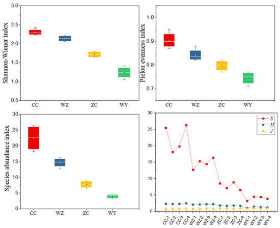
Figure 8.
Plant community species diversity index.
3.3. Effect of Temperature on Coal Gangue Pile Nutrients
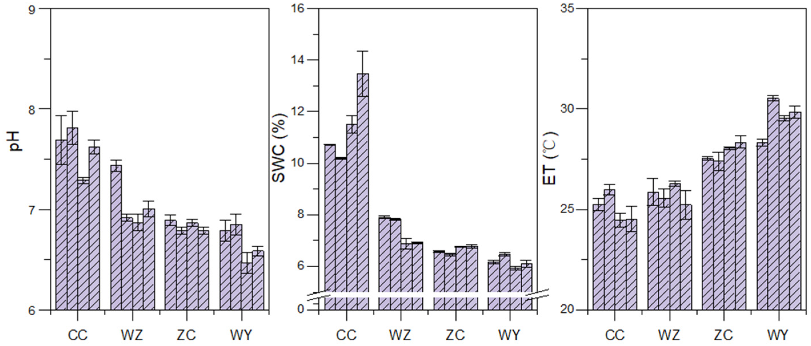
The spontaneous combustion of coal gangue piles releases acidic elements, which leads to an increase in soil acidity and affects soil properties. As shown in the Figure 9, the soil pH range is between 6.54 and 7.93. The soil pH of the spontaneous gangue pile is lower than that of the unburned gangue pile soil. The acidification of the spontaneous combustion gangue pile soil will directly damage the roots of plants. This then affect the growth and development of the entire plant. The temperature of coal gangue piles changes drastically, which directly affects the change of soil moisture content. The soil moisture content ranges from 5.93–13.47%. The soil moisture content of spontaneous combustion coal gangue is the lowest, and coal gangue piles have the highest water content. The high temperature causes the evaporation of soil moisture from coal gangue piles. Detecting the soil temperature, it is found that the temperature of soil is between 24.46 and 30.22 °C. The ground temperature of spontaneous combustion coal gangue piles is generally higher than that of coal gangue piles that have not been spontaneously burned, which corresponds to the UAV thermal infrared image.
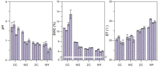
Figure 9.
Physical properties of coal gangue piles. SWC: soil water content; ET: effective soil temperature.
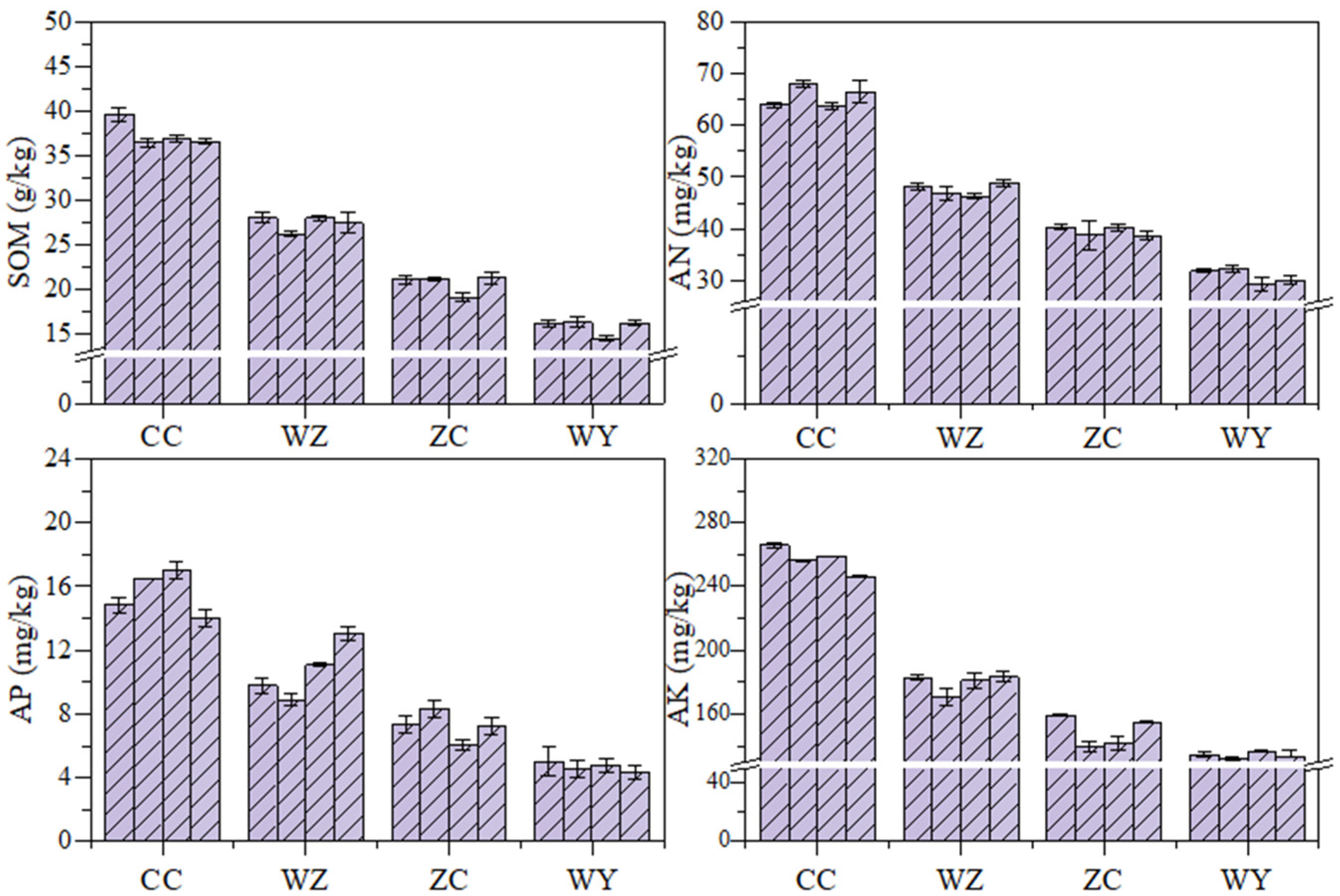
The soil nutrients of coal gangue piles with different levels of spontaneous combustion are shown in the Figure 10. The average soil organic matter contents in CC, WZ, ZC and WY were 36.59 g/kg, 27.38 g/kg, 20.62 g/kg and 15.75 g/kg, respectively. The average soil available nitrogen content was 65.56 mg/kg, 47.60 mg/kg, 39.51 mg/kg and 30.89 mg/kg. The average available phosphorus content was 15.58 mg/kg, 10.70 mg/kg, 7.23 mg/kg and 4.68 mg/kg, respectively. The average available potassium content in soil was 256.83 mg/kg, 179.21 mg/kg, 148.53 mg/kg and 133.75 mg/kg, respectively. Compared with spontaneous combustion coal gangue piles, the soil organic matter, available nitrogen, available phosphorus, and available potassium are relatively higher in unspontaneous combustion coal gangue piles. The nonparametric test (Kruskal–Wallis method) on the soil nutrients of coal gangue piles with different spontaneous combustion levels showed that there are significant differences in soil organic matter, available nitrogen, available phosphorus and available potassium in coal gangue piles with different levels of spontaneous combustion (p < 0.05).
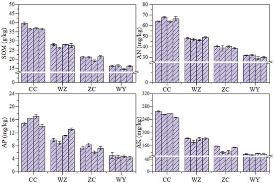
Figure 10.
Chemical properties of coal gangue piles. SOM: soil organic matter; AN: total nitrogen; AP: available phosphorus; AK: available potassium.
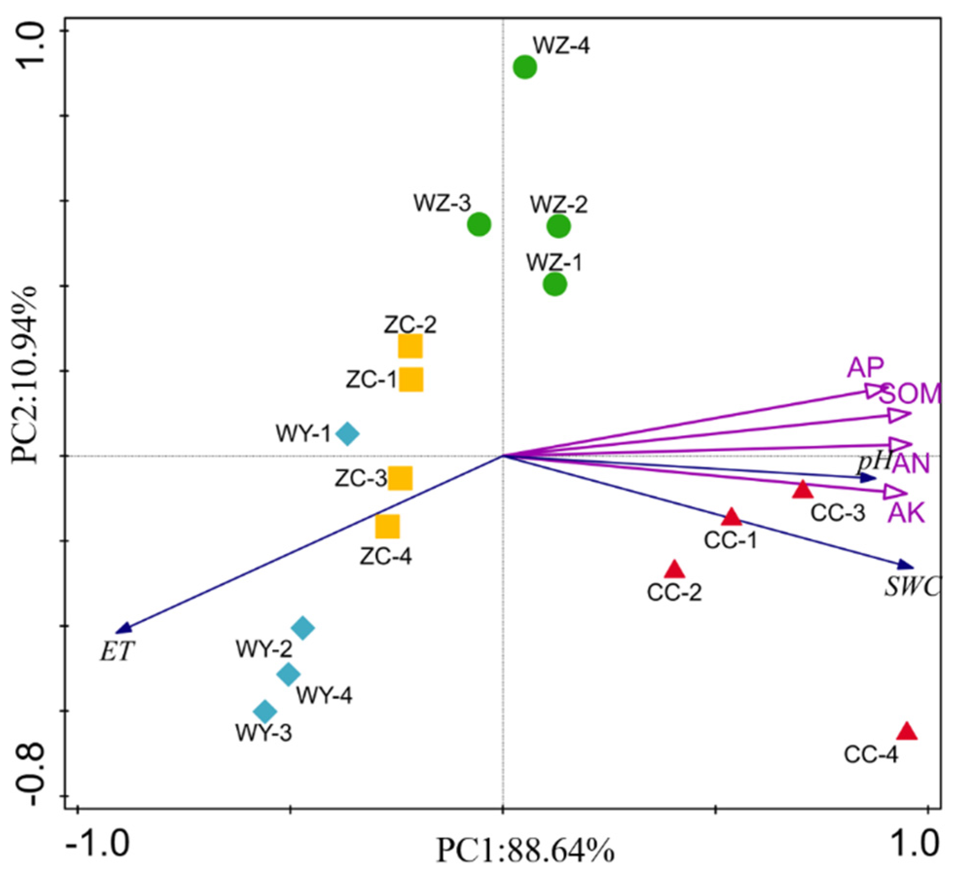
Principal component analysis of the physical and chemical properties of coal gangue pile soil with different degrees of spontaneous combustion. As shown in the Figure 11, PC1 explained 88.64% of the total variance, and PC2 explained 10.94% of the variance. The habitat factor that has the greatest effect on the first ordination axis is soil water content. The spontaneous combustion coal gangue piles negatively correlate with soil temperature and positively correlate with soil moisture and pH. Soil organic matter, available nitrogen, available phosphorus, and available potassium are the main influencing factors, which significantly affect the soil quality of coal gangue piles with different levels of spontaneous combustion. We apply Principal Component Analysis (PCA) to the research results. The samples of soil properties are roughly grouped, and the distance between the samples represents the degree of difference. The ZC sample is close to the WY sample, indicating that the soil properties of the coal gangue piles in ZC and WY coal mines are similar. In addition, the distance between ZC and WY is close to the ground temperature, indicating that the ground temperature of WY and ZC coal gangue piles has a more serious impact on soil properties than other coal gangue piles. Therefore, the clustering in the figure more intuitively explains the previous results and further emphasizes the relationship between soil quality and ground temperature.
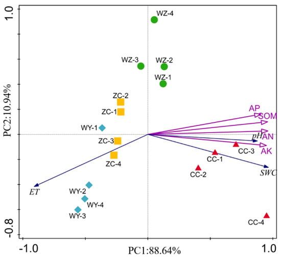
Figure 11.
Principal component analysis of coal gangue pile properties. SWC: soil water content; ET: effective soil temperature; SOM: soil organic matter; AN: total nitrogen; AP: available phosphorus; AK: available potassium.
3.4. Response of Vegetation Community Structure to Coal Gangue Pile Environmental Factors
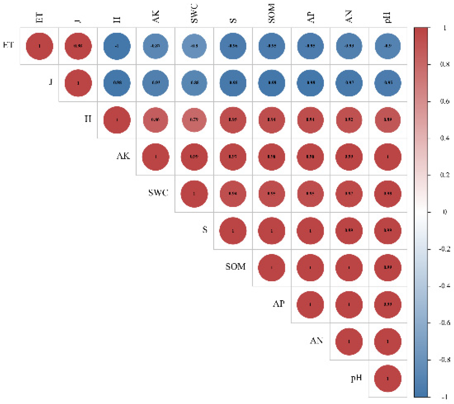
Pearson’s correlations analysis was conducted between plant community species diversity index and soil properties (Table 3). The results showed that plant community diversity was significantly correlated with soil properties (p < 0.05), Shannon–Wiener index and Species abundance index were significantly negatively correlated with ground temperature, and significantly positively correlated with other soil properties; Pielou’s index was positively correlated with ground temperature Related. Furthermore, the correlation between the soil physicochemical properties and plant community species diversity index was analyzed (Figure 12). Consistent with the above.

Table 3.
Pearson’s correlations between the vegetation community structure and environmental factors.
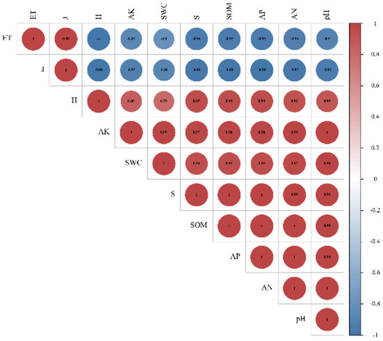
Figure 12.
Correlations of soil characteristics and plant community species diversity index.
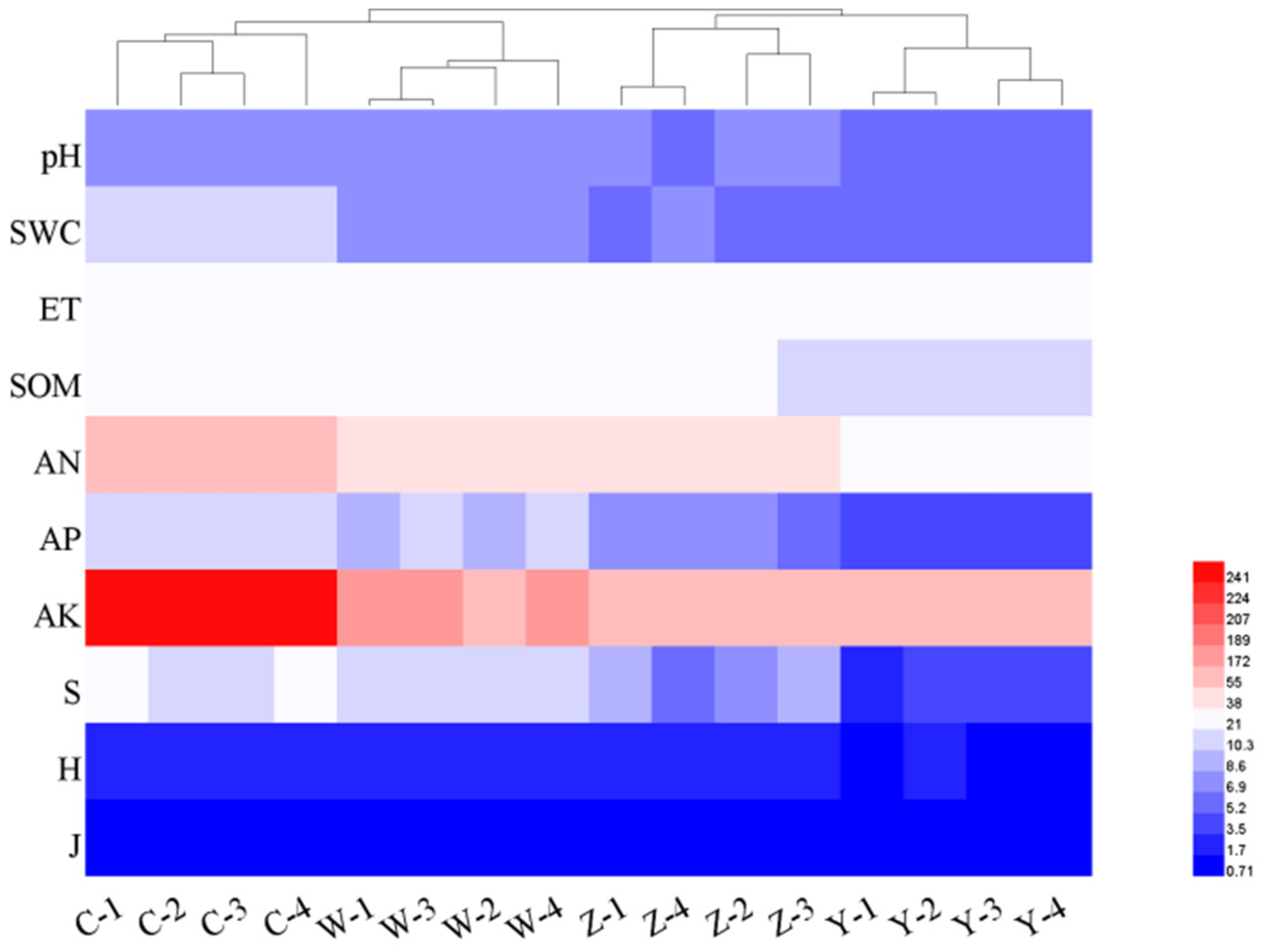
Cluster analysis of plant community species diversity and soil properties of coal gangue piles with different degrees of spontaneous combustion (Figure 13). The results show that coal gangue piles with different levels of spontaneous combustion can be divided into two categories: gangue piles that have been spontaneously burned and gangue piles that have not spontaneously burned; the impact factors are mainly divided into two categories: ground temperature and plant community diversity soil properties. The driving factors of soil variation in coal gangue piles are temperature and plant community diversity soil properties, of which temperature has the greatest influence.
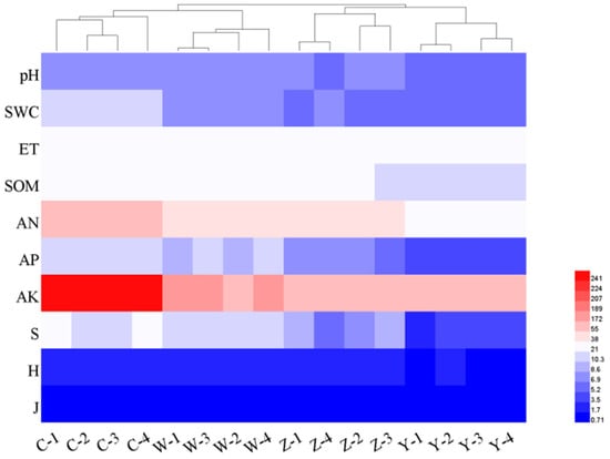
Figure 13.
Clustering heat map of coal gangue pile plant and soil index. SWC: soil water content; ET: effective soil temperature; SOM: soil organic matter; AN: total nitrogen; AP: available phosphorus; AK: available potassium; H: Shannon–Wiener index, J: Pielou’s index; S: Species abundance index. Euclidean distance was used for both row and column distance measurement.
4. Discussion
As a particular site, coal gangue piles have many factors affecting the construction of vegetation. Most of these effects are negative, and the factors pose a stress to the growth of plants and severely restrict the vegetation construction of this site. The stress or damage of these restriction factors to plants is sometimes single, sometimes double, and even several stress factors simultaneously cause cross damage to plants. Through experimental research and investigation and analysis of spontaneous combustion coal gangue piles in Lu’an mining area, it is found that spontaneous combustion of coal gangue piles leads to abnormal soil surface temperature, decline of soil nutrients and reduced vegetation community diversity.
The physiological damage caused by excessive temperature in the environment of plants under high temperature stress is called high temperature damage, also known as heat damage [17]. When the environmental temperature reaches a higher temperature for plant growth, high temperature stress is formed on the plant. High temperature stress causes abnormal flowering and fruit setting in some plants. In nature, high temperature is often combined with other environmental factors, especially strong light and low humidity, to produce stress on plants [18]. The ability of plants to adapt to high temperature stress is called heat resistance. For example, plant seedlings show symptoms of wilting due to burns of young stem tissues near the ground due to excessive soil temperature [19]; This disease occurs more severely in black soil, sandy soil, and drought conditions with large temperature changes. The mechanism of high temperature harming plants is mainly the activity of certain enzymes, which inactivates the activity of other enzymes, which leads to abnormal biochemical reactions and cell death in plants [20]. The direct damage of high temperature stress to plants is protein denaturation, biofilm structure damage, and physiological and biochemical metabolic disorders in the body [21]. High temperature can cause protein polymerization and denaturation, destruction of cell plasma membrane, suffocation and release of certain toxic substances. Heat damage often coexists with drought, causing water loss and wilting. Different plants endure different higher temperatures, and different organs of the same plant have greater heat tolerance. Stress is also related to organelles such as chloroplasts, mitochondria, peroxisomes, nuclei, and cell walls [3]. Roots are more sensitive to high temperature and adversity, followed by reproductive organs. After leaves, old leaves have stronger heat resistance than young leaves, trunks have stronger heat resistance than branches and woody plants have stronger heat resistance than herbs [22]. Therefore, the spontaneous combustion of coal gangue piles leads to increased soil surface temperature, damage to vegetation roots, damage to plants and reduced vegetation.
Spontaneous combustion of coal gangue will produce a large amount of salt [23]. It has been observed that the salt content is closely related to high temperature. In the high-temperature area of the gangue pile, the salt content is high, the crystal layer is thick and the patch area is large. As the distance increases, the ground temperature decreases and the salt content decreases significantly, so that no salt spots can be seen and plant growth begins [24]. When subjected to salt stress plants, photosynthetic rate, transpiration rate, intercellular carbon dioxide concentration, stomatal conductance is affected to different degrees [25]. Carlson [26] investigated the dead zone of vegetation near coal gangue piles that had been accumulated for 15 years and found that the leachate of coal gangue caused the salt content of the surrounding soil to increase, the electrical conductivity exceeded 4 dS/m, and the soil pH was less than 3.5. The acid of spontaneous combustion coal gangue pile comes from the acidic elements released during the spontaneous combustion of coal gangue, which can smell a strong acid taste. When soil acidity increases, it will affect the mineral nutrition metabolism at the morphological, tissue, organ, and molecular levels [27]. The temperature of the gangue pile that has been rehabilitated changes steadily, and its water content shows a stable trend, while the gangue pile with spontaneous combustion tends to generate a large amount of heat accumulation at the bottom of the overburden, and the heat conduction effect of the soil causes the heat to be continuously transferred to the surface and aggravated This reduces the evaporation of water in the soil. When the heat continues to rise, the surface temperature increases and the soil moisture content decreases. The nature of soil and various factors in the environment have a direct impact on vegetation growth. Differences in soil physical and chemical properties and soil nutrients may affect community structure, species diversity and productivity levels. The level of nutrient content in the soil directly affects the productivity of the community. The richer the soil nutrient, the higher the community productivity [28]. Tilman [29] suggested that high plant diversity can more completely utilize the restrictive nutrients in the soil and reduce the leaching loss of N in the ecosystem. At the same time, a highly diverse ecosystem can maintain a higher proportion of restrictive nutrients, increasing the total reserves of soil nutrients, thereby increasing productivity. Soil enzymes are involved in the whole process of soil genesis, development and the formation and evolution of soil fertility, and have a certain influence on plant growth [30]. In addition, soil microorganisms promote the development of plant roots by releasing nutrient elements in hardly soluble minerals, improving plant resistance, degrading pollutants, and reducing pathogenic bacteria, which in turn promotes vegetation growth [31].
In the vegetation construction of coal gangue piles, high temperature stress is the main factor affecting plant survival. Drought, salt damage, acid damage, nutrient deficiency and soil erosion are the most important factors affecting the vegetation construction of spontaneous combustion coal gangue piles, but they can be improved artificially by certain measures. Vegetation is in the process of continuously adapting and transforming the properties and functions of the soil, and the changes in soil fertility provide pre-nutrient conditions for the settlement and reproduction of successive species. Soil temperature leads to changes in vegetation communities, which will cause litter return and changes in root system activities, thereby affecting the structure of vegetation communities. Changes in the soil environment will in turn affect the species composition, growth and development status, community types and vegetation distribution patterns of vegetation.
At present, the methods for monitoring the spontaneous combustion of gangue in China, such as direct detection by temperature sensor or thermal infrared method to obtain the surface temperature of gangue. Application of UAV thermal infrared remote sensing to identify coal fires [32] and soil movement in a self-burning coal waste pile [33]. The data collection uses the same technology, that is, the UAV is equipped with a thermal infrared sensor to obtain information on the surface temperature. The research content of this paper is quite different from that of coal fire identification. The research objective of coal fire identification is to determine the spontaneous combustion area and possible spontaneous combustion area by using UAV images, so as to facilitate the adoption of fire extinguishing measures. The research object of this paper is no fire or obvious burning coal gangue pile that has undergone land reclamation. By studying the influence of the abnormal surface temperature of the gangue hills on vegetation growth during the mining area reclamation process, it is convenient to screen out the native vegetation in the abnormal ground temperature area. If the future high temperature anomaly areas can be monitored and warned in time during the heating stage of gangue hills, the effectiveness of gangue hills treatment will be greatly improved. The sensitivity of plant roots to temperature is directly reflected in the growth of plants. The index of plant population can also give early warning to the abnormal area of coal gangue hill temperature. Based on remote sensing, we will use vegetation index and model index to invert the correlation between coal gangue pile temperatures and vegetation.
5. Conclusions
In this study, we carried out UAV monitoring, experimental research and investigation and analysis of coal gangue piles with different degrees of spontaneous combustion in the Lu ‘an Coal district. In the vegetation construction of coal gangue piles, high-temperature stress is the main factor affecting plant survival. It is caused by changes in coal gangue pile temperatures, with the soil surface temperature is high, causing damage to plant. The spontaneous combustion coal gangue pile has fewer vegetation types, the plant community species diversity index (Shannon–Wiener index, Pielou’s index and Species abundance index) fluctuates slightly, the community complexity is low, and the plant diversity is reduced. In the plant–soil system, vegetation affects the soil, and soil restricts vegetation. Multiple factors affect the vegetation construction of spontaneous combustion coal gangue piles, and at the same time cause cross-damage to plants. Salinity, drought, high temperature, acidification, etc. usually coexist on spontaneous combustion coal gangue piles and affect vegetation construction. Soil acidification of spontaneous combustion coal gangue piles reduces water content and soil organic matter, available nitrogen, available potassium, and available phosphorus. The spontaneous combustion of coal gangue resulted in abnormal soil surface temperature, decreased soil nutrient, and decreased vegetation community diversity.
Author Contributions
Conceptualization, M.R. and Z.H.; methodology, M.R.; software, X.D.; validation, T.Z., X.N. and Z.H.; formal analysis, M.R.; investigation, T.Z. and X.N.; resources, Z.H.; data curation, X.D.; writing—original draft preparation, M.R.; writing—review and editing, M.R.; visualization, M.R.; supervision, X.D.; project administration, Z.H.; funding acquisition, Z.H. All authors have read and agreed to the published version of the manuscript.
Funding
This research was funded by the National Key Research and Development Program (grant numbers 2019YFC1805003 and 2020YFC1806505).
Institutional Review Board Statement
Not applicable.
Informed Consent Statement
Not applicable.
Data Availability Statement
Not applicable.
Acknowledgments
I The authors thank anonymous reviewers for their constructive comments and suggestions which helped to improve the manuscript.
Conflicts of Interest
The authors declare no conflict of interest. The funders had no role in the design of the study; in the collection, analyses, or interpretation of data; in the writing of the manuscript; or in the decision to publish the results.
References
- Liang, Y.; Liang, H.; Zhu, S. Mercury emission from spontaneously ignited coal gangue hill in Wuda coalfield, Inner Mongolia, China. Fuel 2016, 182, 525–530. [Google Scholar] [CrossRef]
- Zhao, Y.; Zhang, J.; Chou, C.; Li, Y.; Wang, Z.; Ge, Y.; Zheng, C. Trace element emissions from spontaneous combustion of gob piles in coal mines, Shanxi, China. Int. J. Coal Geol. 2008, 73, 52–62. [Google Scholar] [CrossRef]
- Zhu, J. Abiotic Stress Signaling and Responses in Plants. Cell 2016, 167, 313–324. [Google Scholar] [CrossRef]
- Wang, S.; Luo, K.; Wang, X.; Sun, Y. Estimate of sulfur, arsenic, mercury, fluorine emissions due to spontaneous combustion of coal gangue: An important part of Chinese emission inventories. Environ. Pollut. 2016, 209, 107–113. [Google Scholar] [CrossRef] [PubMed]
- Carr, J.A.; D’Odorico, P.; McGlathery, K.J.; Wiberg, P.L. Stability and resilience of seagrass meadows to seasonal and interannual dynamics and environmental stress. J. Geophys. Res. Biogeosci. 2015, 117, 1007. [Google Scholar] [CrossRef]
- Teskey, R.O.; Hinckley, T.M. Influence of temperature and water potential on root growth of white oak. Physiol. Plant. 1981, 52, 363–369. [Google Scholar] [CrossRef]
- Jihong, X.; Hongbei, G.; Mingan, S. Study of the Effect of Soil Temperature on Soil Water Infiltration. J. Soil Water Conserv. 2009, 23, 217–220. [Google Scholar]
- Fucang, Z.; Yiping, Z.; Junchang, Z. Temperature effect on soil water retention. Acta Pedol. Sin. 1997, 2, 160–169. [Google Scholar]
- Yamakawa, Y.; Kishikawa, H. On the Effect of Temperature upon the Division and Elongation of Cells in the Root of Rice Plant. Jpn. J. Crop. Sci. 2008, 26, 94–95. [Google Scholar] [CrossRef]
- Sandve, S.R.; Kosmala, A.; Rudi, H.; Fjellheim, S.; Rapacz, M.; Yamada, T.; Rognli, O.A. Molecular mechanisms underlying frost tolerance in perennial grasses adapted to cold climates. Plant Sci. 2011, 180, 69–77. [Google Scholar] [CrossRef]
- Pan, R.; Zheng, L.; Jia, H.; Ma, G. The environmental pollution and control of coal gangue spontaneous combustion in mining. Electron. J. Geotech. Eng. 2015, 20, 3555–3562. [Google Scholar]
- Donglin, W.; Hao, F.; Yi, L.I.; Afeng, Z. Impacts of Soil Water and Temperature Effects on CO2 Emissions in Winter Wheat Field under Gravel Mulching Condition; Transactions of the Chinese Society for Agricultural Machinery: Beijing, China, 2017. [Google Scholar]
- Niinemets, Ü.; Kull, K. Leaf structure vs. nutrient relationships vary with soil conditions in temperate shrubs and trees. Acta Oecol. 2003, 24, 209–219. [Google Scholar] [CrossRef]
- Zhang, F.; Hu, Z.; Fu, Y.; Yang, K.; Wu, Q.; Feng, Z. A New Identification Method for Surface Cracks from UAV Images Based on Machine Learning in Coal Mining Areas. Remote Sens. 2020, 12, 1571. [Google Scholar] [CrossRef]
- Bowman, R.A.; Cole, C.V. An exploratory method for fractionation of organic phosphorus from grassland soils. Soil Sci. 1978, 125, 95–101. [Google Scholar] [CrossRef]
- Xinyu, Z.; Yang, Y.; Chuang, Z.; Shuli, N.; Hao, Y.; Guirui, Y.; Huimin, W.; Evgenia, B.; Yakov, K.; Dashuan, T.; et al. Contrasting responses of phosphatase kinetic parameters to nitrogen and phosphorus additions in forest soils. Funct. Ecol. 2018, 32, 106–116. [Google Scholar]
- Zhang, Y.; Song, H.; Wang, X.; Zhou, X.; Zhang, K.; Chen, X.; Liu, J.; Han, J.; Wang, A. The Roles of Different Types of Trichomes in Tomato Resistance to Cold, Drought, Whiteflies, and Botrytis. Agronomy 2020, 10, 411. [Google Scholar] [CrossRef]
- Ward, E.J.; Domec, J.C.; Laviner, M.A.; Fox, T.R.; Sun, G.; Mcnulty, S.; King, J.; Noormets, A. Fertilization intensifies drought stress: Water use and stomatal conductance of Pinus taeda in a midrotation fertilization and throughfall reduction experiment. For. Ecol. Manag. 2015, 355, 72–82. [Google Scholar] [CrossRef]
- Garner, W.W.; Allard, H.A. Photoperiodism, the response of the plant to relative length of day and night. Science 1922, 55, 582–583. [Google Scholar] [CrossRef] [PubMed]
- Sangwan, V.; Orvar, B.L.; Beyerly, J.; Hirt, H.; Dhindsa, R.S. Opposite changes in membrane fluidity mimic cold and heat stress activation of distinct plant MAP kinase pathways. Plant J. 2010, 31, 629–638. [Google Scholar] [CrossRef]
- Scharf, K.D.; Berberich, T.; Ebersberger, I.; Nover, L. The plant heat stress transcription factor (Hsf) family: Structure, function and evolution. Biochim. Biophys. Acta 2012, 1819, 104–119. [Google Scholar] [CrossRef] [PubMed]
- Zhang, X.; Lu, G.; Long, W.; Zou, X.; Nishio, T. Recent progress in drought and salt tolerance studies in Brassica crops. Breed. Sci. 2014, 64, 60–73. [Google Scholar] [CrossRef] [PubMed]
- Querol, X.; Izquierdo, M.; Monfort, E.; Alvarez, E.; Font, O.; Moreno, T.; Alastuey, A.; Zhuang, X.; Lu, W.; Wang, Y. Environmental characterization of burnt coal gangue banks at Yangquan, Shanxi Province, China. Int. J. Coal Geol. 2008, 75, 93–104. [Google Scholar] [CrossRef]
- Chengliang, Z. The Habitat and Vegetation Constructing for Spontaneous Combustion Gangue Pile in Yangquan City, Shanxi Province; Beijing Forestry University: Beijing, China, 2008; Volume 157. [Google Scholar]
- Guo, Y.; Jie, L.; Ya-Chen, L.; Hai, W.; Yi-Wei, M.O. Effects of Salt Stress on Photosynthetic Characteristics and Stoma Structure of Two Kinds of Bracketplants. Hub Agric. Sci. 2016. [Google Scholar] [CrossRef]
- Carlson, C.L.; Carlson, C.A. Impacts of coal pile leachate on a forested wetland in South Carolina. Water Air Soil Pollut. 1994, 72, 89–109. [Google Scholar] [CrossRef]
- Sahrawat, K.A. Iron Toxicity in Wetland Rice and the Role of Other Nutrients. J. Plant Nutr. 2005, 27, 1471–1504. [Google Scholar] [CrossRef]
- Tilman, D. Secondary Succession and the Pattern of Plant Dominance Along Experimental Nitrogen Gradients. Ecol. Monogr. 1987, 57, 189–214. [Google Scholar] [CrossRef]
- Tilman, D. The Influence of Functional Diversity and Composition on Ecosystem Processes. Science 1997, 277, 1300–1302. [Google Scholar] [CrossRef]
- Changwei, A. The relationship between soil microorganism and soil fertility in the process of transforming Kangping’s desertification. Sci. Technol. Rev. 2010, 28, 45–49. [Google Scholar]
- Otte, L.M.A.M. Metal and metalloid removal in constructed wetlands, with emphasis on the importance of plants and standardized measurements: A review. Environ. Pollut. 2010, 158, 3447–3461. [Google Scholar]
- He, X.; Yang, X.; Luo, Z.; Guan, T. Application of unmanned aerial vehicle (UAV) thermal infrared remote sensing to identify coal fires in the Huojitu coal mine in Shenmu city, China. Sci. Rep. 2020, 10, 13895. [Google Scholar] [CrossRef]
- Teodoro, A.; Fernandes, J.; Santos, P.; Duarte, L.; Flores, D. Monitoring of soil movement in a self-burning coal waste pile with UAV imagery. In Earth Resources and Environmental Remote Sensing/GIS Applications XI; International Society for Optics and Photonics: Bellingham, WA, USA, 2020. [Google Scholar] [CrossRef]
Publisher’s Note: MDPI stays neutral with regard to jurisdictional claims in published maps and institutional affiliations. |
© 2022 by the authors. Licensee MDPI, Basel, Switzerland. This article is an open access article distributed under the terms and conditions of the Creative Commons Attribution (CC BY) license (https://creativecommons.org/licenses/by/4.0/).

