
Lidar-Imagery Fusion Reveals Rapid Coastal Forest Loss in Delaware Bay Consistent with Marsh Migration


Abstract
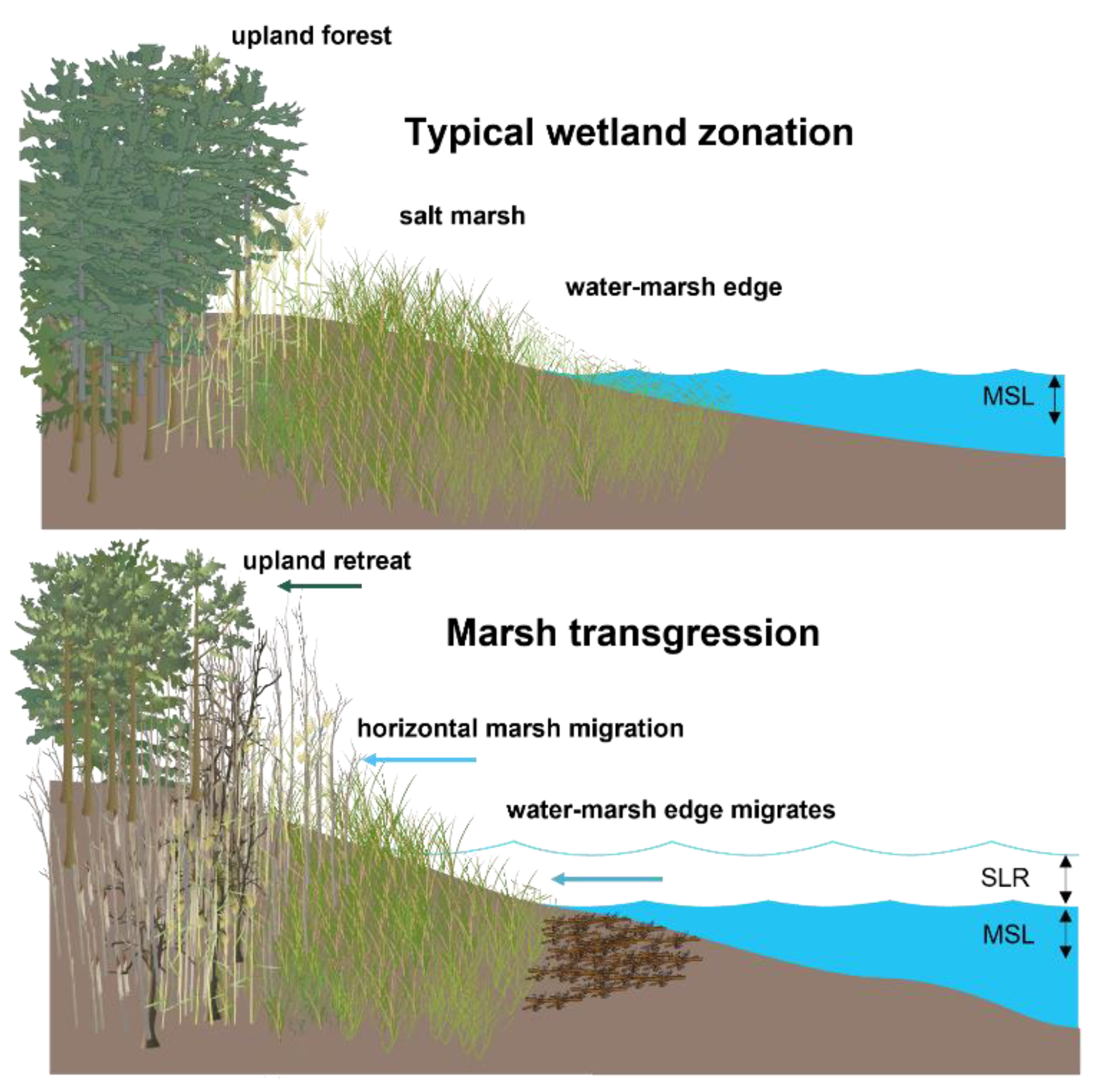
:1. Introduction
2. Materials and Methods
2.1. Study Area
2.2. Remote Sensing Data
2.2.1. Airborne Lidar Data
2.2.2. NAIP Imagery
2.3. Random Forest Classification
2.4. Change Map and Accuracy Assessment
2.5. Landscape Change Analysis
3. Results
3.1. Classification and Change Map Results
3.2. Landscape Change Analysis
4. Discussion
4.1. Classification and Change Map
4.2. Landscape Change Analysis
4.3. Drivers for Forest Loss–Episodic Events
5. Conclusions and Future Directions
Author Contributions
Funding
Data Availability Statement
Acknowledgments
Conflicts of Interest
References
- Mcleod, E.; Chmura, G.L.; Bouillon, S.; Salm, R.; Björk, M.; Duarte, C.M.; Lovelock, C.E.; Schlesinger, W.H.; Silliman, B.R. A Blueprint for Blue Carbon: Toward an Improved Understanding of the Role of Vegetated Coastal Habitats in Sequestering CO2. Front. Ecol. Environ. 2011, 9, 552–560. [Google Scholar] [CrossRef]
- Gedan, K.B.; Silliman, B.R.; Bertness, M.D. Centuries of Human-Driven Change in Salt Marsh Ecosystems. Ann. Rev. Mar. Sci. 2009, 1, 117–141. [Google Scholar] [CrossRef] [PubMed]
- Sallenger, A.H.; Doran, K.S.; Howd, P.A. Hotspot of Accelerated Sea-Level Rise on the Atlantic Coast of North America. Nat. Clim. Chang. 2012, 2, 884–888. [Google Scholar] [CrossRef]
- Smart, L.S.; Taillie, P.J.; Poulter, B.; Vukomanovic, J.; Singh, K.K.; Swenson, J.J.; Mitasova, H.; Smith, J.W.; Meentemeyer, R.K. Aboveground Carbon Loss Associated with the Spread of Ghost Forests as Sea Levels Rise. Environ. Res. Lett. 2020, 15, 104028. [Google Scholar] [CrossRef]
- Bertness, M.D.; Ellison, A.M. Determinants of Pattern in a New England Salt Marsh Plant Community. Ecol. Monogr. 1987, 57, 129–147. [Google Scholar] [CrossRef]
- Kirwan, M.L.; Temmerman, S.; Skeehan, E.E.; Guntenspergen, G.R.; Fagherazzi, S. Overestimation of Marsh Vulnerability to Sea Level Rise. Nat. Clim. Chang. 2016, 6, 253–260. [Google Scholar] [CrossRef]
- Gedan, K.B.; Epanchin-Niell, R.; Qi, M. Rapid Land Cover Change in a Submerging Coastal County. Wetlands 2020, 40, 1717–1728. [Google Scholar] [CrossRef]
- Shaw, P.; Jobe, J.; Gedan, K.B. Environmental Limits on the Spread of Invasive Phragmites Australis into Upland Forests with Marine Transgression. Estuaries Coasts 2022, 45, 539–550. [Google Scholar] [CrossRef]
- Brinson, M.M.; Christian, R.R.; Blum, L.K. Multiple States in the Sea-Level Induced Transition from Terrestrial Forest to Estuary. Estuaries 1995, 18, 648. [Google Scholar] [CrossRef]
- Kirwan, M.L.; Megonigal, J.P. Tidal Wetland Stability in the Face of Human Impacts and Sea-Level Rise. Nature 2013, 504, 53–60. [Google Scholar] [CrossRef]
- Fagherazzi, S.; Anisfeld, S.C.; Blum, L.K.; Long, E.V.; Feagin, R.A.; Fernandes, A.; Kearney, W.S.; Williams, K. Sea Level Rise and the Dynamics of the Marsh-Upland Boundary. Front. Environ. Sci. 2019, 7, 25. [Google Scholar] [CrossRef]
- Kirwan, M.L.; Gedan, K.B. Sea-Level Driven Land Conversion and the Formation of Ghost Forests. Nat. Clim. Chang. 2019, 9, 450–457. [Google Scholar] [CrossRef]
- Raabe, E.A.; Stumpf, R.P. Expansion of Tidal Marsh in Response to Sea-Level Rise: Gulf Coast of Florida, USA. Estuaries Coasts 2016, 39, 145–157. [Google Scholar] [CrossRef]
- Williams, K.; Ewel, K.C.; Stumpf, R.P.; Putz, F.E.; Workman, T.W. Sea-Level Rise and Coastal Forest Retreat on the West Coast of Florida, USA. Ecology 1999, 80, 2045–2063. [Google Scholar] [CrossRef]
- Poulter, B. Interactions between Landscape Disturbance and Gradual Environmental Change: Plant Community Migration in Response to Fire and Sea Level Rise; Duke University: Durham, NC, USA, 2005. [Google Scholar]
- Robichaud, A.; Bégin, Y. The Effects of Storms and Sea-Level Rise on a Coastal Forest Margin in New Brunswick, Eastern Canada. J. Coast. Res. 1997, 13, 429–439. [Google Scholar]
- Webster, P.J.; Holland, G.J.; Curry, J.A.; Chang, H.-R. Changes in Tropical Cyclone Number, Duration, and Intensity in a Warming Environment. Science 2005, 309, 1844–1846. [Google Scholar] [CrossRef]
- Kozlowski, T.T. (Ed.) Flooding and Plant Growth. In Physiological Ecology; Academic Press: Orlando, FL, USA, 1984; ISBN 978-0-12-424120-6. [Google Scholar]
- Kozlowski, T.T. Responses of Woody Plants to Flooding and Salinity. Tree Physiol. 1997, 17, 490. [Google Scholar] [CrossRef]
- Kozlowski, T.T. Physiological-Ecological Impacts of Flooding on Riparian Forest Ecosystems. Wetlands 2002, 22, 550–561. [Google Scholar] [CrossRef]
- Blood, E.R.; Anderson, P.; Smith, P.A.; Nybro, C.; Ginsberg, K.A. Effects of Hurricane Hugo on Coastal Soil Solution Chemistry in South Carolina. Biotropica 1991, 23, 348. [Google Scholar] [CrossRef]
- Merry, K.; Bettinger, P.; Hepinstall, J. Physical and Biological Responses of Forests to Tropical Cyclones Affecting the United States Atlantic Ocean and Gulf of Mexico Coasts. Am. J. Environ. Sci. 2009, 5, 16–32. [Google Scholar] [CrossRef]
- Kearney, W.S.; Fernandes, A.; Fagherazzi, S. Sea-Level Rise and Storm Surges Structure Coastal Forests into Persistence and Regeneration Niches. PLoS ONE 2019, 14, e0215977. [Google Scholar] [CrossRef] [PubMed] [Green Version]
- Tully, K.; Gedan, K.; Epanchin-Niell, R.; Strong, A.; Bernhardt, E.S.; BenDor, T.; Mitchell, M.; Kominoski, J.; Jordan, T.E.; Neubauer, S.C.; et al. The Invisible Flood: The Chemistry, Ecology, and Social Implications of Coastal Saltwater Intrusion. BioScience 2019, 69, 368–378. [Google Scholar] [CrossRef]
- Schuerch, M.; Spencer, T.; Temmerman, S.; Kirwan, M.L.; Wolff, C.; Lincke, D.; McOwen, C.J.; Pickering, M.D.; Reef, R.; Vafeidis, A.T.; et al. Future Response of Global Coastal Wetlands to Sea-Level Rise. Nature 2018, 561, 231–234. [Google Scholar] [CrossRef] [PubMed]
- Törnqvist, T.E.; Cahoon, D.R.; Morris, J.T.; Day, J.W. Coastal Wetland Resilience, Accelerated Sea-Level Rise, and the Importance of Timescale. AGU Adv. 2021, 2, e2020AV000334. [Google Scholar] [CrossRef]
- White, E.E.; Ury, E.A.; Bernhardt, E.S.; Yang, X. Climate Change Driving Widespread Loss of Coastal Forested Wetlands Throughout the North American Coastal Plain. Ecosystems 2021, 25, 812–827. [Google Scholar] [CrossRef]
- Magolan, J.L.; Halls, J.N. A Multi-Decadal Investigation of Tidal Creek Wetland Changes, Water Level Rise, and Ghost Forests. Remote Sens. 2020, 12, 1141. [Google Scholar] [CrossRef]
- Smith, J.A.M. The Role of Phragmites Australis in Mediating Inland Salt Marsh Migration in a Mid-Atlantic Estuary. PLoS ONE 2013, 8, e65091. [Google Scholar] [CrossRef]
- Dubayah, R.; Blaire, J.B.; Bufton, J.L.; Clark, D.B.; Jaja, J.; Knox, R.G.; Luthcke, S.P.; Weishampel, J.F. The Vegetation Canopy Lidar Mission. In Proceedings of the Land Satellite Information in the Next 1 Decade II: Sources and Applications, Bethesda, MD, USA, 20 March 1997; pp. 100–112. [Google Scholar]
- Lovell, J.L.; Jupp, D.L.B.; Newnham, G.J.; Coops, N.C.; Culvenor, D.S. Simulation Study for Finding Optimal Lidar Acquisition Parameters for Forest Height Retrieval. For. Ecol. Manag. 2005, 214, 398–412. [Google Scholar] [CrossRef]
- Zurqani, H.A.; Post, C.J.; Mikhailova, E.A.; Cope, M.P.; Allen, J.S.; Lytle, B.A. Evaluating the Integrity of Forested Riparian Buffers over a Large Area Using LiDAR Data and Google Earth Engine. Sci. Rep. 2020, 10, 14096. [Google Scholar] [CrossRef]
- Anderson, M.G.; Clark, L.; Ferree, C.E.; Jospe, A.; Sheldon, A.O.; Weaver, K.J. The Northeast Habitat Guides: A Companion to the Terrestrial and Aquatic Habitat Maps; The Nature Conservancy: Boston, MA, USA, 2013. [Google Scholar]
- Sacatelli, R.; Lathrop, R.; Kaplan, M.B. Impacts of Climate Change on Coastal Forests in the Northeast US; Rutgers University: New Brunswick, NJ, USA, 2020. [Google Scholar]
- O’neil-Dunne, J. CMS: LiDAR-Derived Tree Canopy Cover for Pennsylvania, USA, 2008; ORNL DAAC: Oak Ridge, TN, USA, 2016.
- Roussel, J.-R.; Auty, D.; Coops, N.C.; Tompalski, P.; Goodbody, T.R.H.; Meador, A.S.; Bourdon, J.-F.; de Boissieu, F.; Achim, A. LidR: An R Package for Analysis of Airborne Laser Scanning (ALS) Data. Remote Sens. Environ. 2020, 251, 112061. [Google Scholar] [CrossRef]
- Torresani, M.; Rocchini, D.; Sonnenschein, R.; Zebisch, M.; Hauffe, H.C.; Heym, M.; Pretzsch, H.; Tonon, G. Height Variation Hypothesis: A New Approach for Estimating Forest Species Diversity with CHM LiDAR Data. Ecol. Indic. 2020, 117, 106520. [Google Scholar] [CrossRef]
- EarthExplorer. Available online: https://earthexplorer.usgs.gov/ (accessed on 11 April 2022).
- Smith, A.B. U.S. Billion-Dollar Weather and Climate Disasters, 1980-Present (NCEI Accession 0209268) 2020. Available online: https://www.ncei.noaa.gov/access/billions/ (accessed on 14 May 2022).
- Liaw, A.; Wiener, M. Classification and Regression by RandomForest. R J. 2002, 2, 18–22. [Google Scholar]
- Kuhn, M.; Wing, J.; Weston, S.; Williams, A.; Keefer, C.; Engelhardt, A.; Cooper, T.; Mayer, Z.; Kenkel, B.; R Core Team; et al. Caret: Classification and Regression Training. Available online: https://CRAN.R-project.org/ (accessed on 19 July 2022).
- Belgiu, M.; Drăguţ, L. Random Forest in Remote Sensing: A Review of Applications and Future Directions. ISPRS J. Photogramm. Remote Sens. 2016, 114, 24–31. [Google Scholar] [CrossRef]
- Breiman, L. Random Forests. Mach. Learn. 2001, 45, 5–32. [Google Scholar] [CrossRef]
- Olofsson, P.; Foody, G.M.; Stehman, S.V.; Woodcock, C.E. Making Better Use of Accuracy Data in Land Change Studies: Estimating Accuracy and Area and Quantifying Uncertainty Using Stratified Estimation. Remote Sens. Environ. 2013, 129, 122–131. [Google Scholar] [CrossRef]
- Stehman, S.V.; Sohl, T.L.; Loveland, T.R. An Evaluation of Sampling Strategies to Improve Precision of Estimates of Gross Change in Land Use and Land Cover. Int. J. Remote Sens. 2005, 26, 4941–4957. [Google Scholar] [CrossRef]
- Card, D. Using Known Map Category Marginal Frequencies to Improve Estimates of Thematic Map Accuracy. Photogramm. Eng. Remote Sens. 1982, 48, 431–439. [Google Scholar]
- FirstMap. Available online: https://firstmap-delaware.opendata.arcgis.com/datasets/?group_ids=53397d2551134caa8e9abb62ff30df12 (accessed on 1 June 2022).
- Kellner, J.R.; Clark, D.B.; Hubbell, S.P. Pervasive Canopy Dynamics Produce Short-Term Stability in a Tropical Rain Forest Landscape. Ecol. Lett. 2009, 12, 155–164. [Google Scholar] [CrossRef]
- Dubayah, R.O.; Sheldon, S.L.; Clark, D.B.; Hofton, M.A.; Blair, J.B.; Hurtt, G.C.; Chazdon, R.L. Estimation of Tropical Forest Height and Biomass Dynamics Using Lidar Remote Sensing at La Selva, Costa Rica: Forest Dynamics Using Lidar. J. Geophys. Res. 2010, 115. [Google Scholar] [CrossRef]
- O’neil-Dunne, J. CMS: LiDAR-Derived Tree Canopy Cover for States in the Northeast USA; ORNL DAAC: Oak Ridge, TN, USA, 2019.
- Herbert, E.R.; Boon, P.; Burgin, A.J.; Neubauer, S.C.; Franklin, R.B.; Ardón, M.; Hopfensperger, K.N.; Lamers, L.P.M.; Gell, P. A Global Perspective on Wetland Salinization: Ecological Consequences of a Growing Threat to Freshwater Wetlands. Ecosphere 2015, 6, 1–43. [Google Scholar] [CrossRef]
- Bhattachan, A.; Emanuel, R.E.; Ardón, M.; Bernhardt, E.S.; Anderson, S.M.; Stillwagon, M.G.; Ury, E.A.; BenDor, T.K.; Wright, J.P. Evaluating the Effects of Land-Use Change and Future Climate Change on Vulnerability of Coastal Landscapes to Saltwater Intrusion. Elem. Sci. Anthropocene 2018, 6, 62. [Google Scholar] [CrossRef]
- Smith, J.A.M.; Hafner, S.F.; Niles, L.J. The Impact of Past Management Practices on Tidal Marsh Resilience to Sea Level Rise in the Delaware Estuary. Ocean Coast. Manag. 2017, 149, 33–41. [Google Scholar] [CrossRef]
- Williams, K.; MacDonald, M. Interactions of Storm, Drought, and Sea-Level Rise on Coastal Forest: A Case Study. J. Coast. Res. 2003, 19, 7. [Google Scholar]
- Anderson, S.M.; Ury, E.A.; Taillie, P.J.; Ungberg, E.A.; Moorman, C.E.; Poulter, B.; Ardón, M.; Bernhardt, E.S.; Wright, J.P. Salinity Thresholds for Understory Plants in Coastal Wetlands. Plant Ecol. 2022, 223, 323–337. [Google Scholar] [CrossRef]
- Goetz, S.; Dubayah, R. Advances in Remote Sensing Technology and Implications for Measuring and Monitoring Forest Carbon Stocks and Change. Carbon Manag. 2011, 2, 231–244. [Google Scholar] [CrossRef]
- Brando, P. Tree Height Matters. Nat. Geosci. 2018, 11, 390–391. [Google Scholar] [CrossRef]
- Krauss, K.W.; Duberstein, J.A. Sapflow and Water Use of Freshwater Wetland Trees Exposed to Saltwater Incursion in a Tidally Influenced South Carolina Watershed. Can. J. For. Res. 2010, 40, 525–535. [Google Scholar] [CrossRef]
- Oswalt, S.N.; Smith, W.B.; Miles, P.D.; Pugh, S.A. Forest Resources of the United States, 2017: A Technical Document Supporting the Forest Service 2020 RPA Assessment; U.S. Department of Agriculture, Forest Service: Washington, DC, USA, 2019; p. WO-GTR-97.
- Clark, J.S. Coastal Forest Tree Populations in a Changing Environment, Southeastern Long Island, New York. Ecol. Monographs 1986, 56, 259–277. [Google Scholar] [CrossRef]
- Osborn, K.; List, J.; Gesch, D.B.; Crowe, J.; Merrill, G.; Constance, E.; Mauck, J.; Lund, C.; Caruso, V.; Kosovich, J. National Digital Elevation Program (NDEP); American Society for Photogrammetry and Remote Sensing: Bethesda, MD, USA, 2001; pp. 83–120. [Google Scholar]
- Anisfeld, S.C.; Kemp, A.C.; O’Connell, J. Salt Marsh Migration into Lawns Revealed by a Novel Sediment-Based Approach. Estuaries Coasts 2019, 42, 1419–1429. [Google Scholar] [CrossRef]
- Station Home Page-NOAA Tides & Currents. Available online: https://tidesandcurrents.noaa.gov/stationhome.html?id=8537121 (accessed on 11 April 2022).
- Historical Hurricane Tracks. Available online: https://coast.noaa.gov/hurricanes/#map=4/32/-80 (accessed on 6 June 2022).
- Ury, E.A.; Yang, X.; Wright, J.P.; Bernhardt, E.S. Rapid Deforestation of a Coastal Landscape Driven by Sea-level Rise and Extreme Events. Ecol. Appl. 2021, 31, e02339. [Google Scholar] [CrossRef]
- Climate at a Glance|National Centers for Environmental Information (NCEI). Available online: https://www.ncdc.noaa.gov/cag/divisional/time-series/0702/pdsi/all/3/2007-2015?base_prd=true&begbaseyear=1901&endbaseyear=2000 (accessed on 14 April 2022).


| Year | Instrument | Flight Altitude (m AGL) | Scan Frequency (Hz) | Pulse Rate (kHz) | Scan Angle | Point Density (Points/m2) |
|---|---|---|---|---|---|---|
| 2007 | Leica Systems ALS-50 | 1400 | 32 | 50 | 20 | 4.1 |
| 2014 | Leica Systems ALS-70 | 1676 | 31.7 | 165 | 17 | 1.3 |
| Class | 1 | 2 | 3 | 4 | Total | Map Area (ha) | Wi | Users | Producers | Overall |
|---|---|---|---|---|---|---|---|---|---|---|
| 1 | 193 | 2 | 1 | 4 | 200 | 19,098 | 0.58 | 0.97 | 0.95 | 0.91 |
| 2 | 45 | 98 | 0 | 57 | 200 | 1216 | 0.04 | 0.49 | 0.50 | |
| 3 | 107 | 3 | 9 | 81 | 200 | 1149 | 0.04 | 0.05 | 0.35 | |
| 4 | 3 | 7 | 0 | 190 | 200 | 11,252 | 0.34 | 0.95 | 0.90 | |
| Total | 348 | 110 | 10 | 332 | 800 | 32,715 |
| Area Calculation Method | Land Transition (ha) | |||
|---|---|---|---|---|
| Non-Forest Remain | Forest to Non-Forest | Non-Forest to Forest | Forest Remain | |
| Pixel count | 19,098 | 1217 | 1149 | 11,252 |
| Error adjusted area | 19,486 ± 708 | 1197 ± 405 | 147 ± 32 | 11,882 ± 806 |
| 2007 Canopy Height (m) | 2014 Canopy Height (m) | ||||||
| Mean | Median | sd | Mean | Median | sd | n | |
| Forest loss | 11.97 | 11.40 | 6.50 | 10.79 | 9.57 | 7.24 | 1,496,807 |
| Forest remain | 16.89 | 17.26 | 6.91 | 17.81 | 18.28 | 7.08 | 25,653,049 |
| Forest growth | 7.59 | 5.43 | 6.15 | 9.73 | 8.61 | 5.91 | 674,500 |
| 2007 Ground Elevation (m) | 2014 Ground Elevation (m) | ||||||
| Mean | Median | sd | Mean | Median | sd | n | |
| Forest loss | 2.99 | 1.31 | 3.92 | 2.96 | 1.28 | 3.91 | 1,496,807 |
| Forest remain | 6.29 | 4.49 | 5.44 | 6.29 | 4.51 | 5.43 | 25,653,049 |
| Forest growth | 3.19 | 1.09 | 4.93 | 3.17 | 1.10 | 4.90 | 674,500 |
| 2007 Height | ||||||||||||||||||||
|---|---|---|---|---|---|---|---|---|---|---|---|---|---|---|---|---|---|---|---|---|
| 2014 Height | <2 | 2–4 | 4–6 | 6–8 | 8–10 | 10–12 | 12–14 | 14–16 | 16–18 | 18–20 | 20–22 | 22–24 | 24–26 | 26–28 | 28–30 | 30–32 | 32–34 | 34–36 | >36 | N |
| <2 | 0.37 | 0.16 | 0.13 | 0.12 | 0.10 | 0.09 | 0.08 | 0.07 | 0.07 | 0.06 | 0.06 | 0.06 | 0.06 | 0.06 | 0.06 | 0.07 | 0.08 | 0.08 | 0.08 | 4344354 |
| 2–4 | 0.15 | 0.20 | 0.08 | 0.05 | 0.04 | 0.03 | 0.02 | 0.02 | 0.02 | 0.01 | 0.01 | 0.01 | 0.01 | 0.01 | 0.01 | 0.01 | 0.01 | 0.01 | 0.01 | 1635554 |
| 4–6 | 0.13 | 0.20 | 0.17 | 0.07 | 0.04 | 0.03 | 0.02 | 0.02 | 0.01 | 0.01 | 0.01 | 0.01 | 0.01 | 0.01 | 0.01 | 0.01 | 0.01 | 0.01 | 0.01 | 1710029 |
| 6–8 | 0.10 | 0.15 | 0.19 | 0.17 | 0.07 | 0.04 | 0.03 | 0.02 | 0.01 | 0.01 | 0.01 | 0.01 | 0.01 | 0.01 | 0.01 | 0.01 | 0.01 | 0.01 | 0.01 | 1840462 |
| 8–10 | 0.07 | 0.11 | 0.16 | 0.20 | 0.17 | 0.07 | 0.04 | 0.03 | 0.02 | 0.01 | 0.01 | 0.01 | 0.01 | 0.01 | 0.01 | 0.01 | 0.01 | 0.01 | 0.01 | 2050641 |
| 10–12 | 0.05 | 0.07 | 0.11 | 0.16 | 0.21 | 0.18 | 0.07 | 0.04 | 0.02 | 0.02 | 0.01 | 0.01 | 0.01 | 0.01 | 0.01 | 0.01 | 0.01 | 0.01 | 0.00 | 2311029 |
| 12–14 | 0.03 | 0.04 | 0.06 | 0.11 | 0.16 | 0.22 | 0.19 | 0.07 | 0.04 | 0.02 | 0.02 | 0.01 | 0.01 | 0.01 | 0.01 | 0.01 | 0.01 | 0.00 | 0.00 | 2580172 |
| 14–16 | 0.03 | 0.02 | 0.03 | 0.05 | 0.09 | 0.16 | 0.24 | 0.21 | 0.08 | 0.04 | 0.02 | 0.02 | 0.01 | 0.01 | 0.01 | 0.01 | 0.01 | 0.01 | 0.00 | 2828951 |
| 16–18 | 0.02 | 0.02 | 0.02 | 0.03 | 0.05 | 0.09 | 0.16 | 0.25 | 0.22 | 0.08 | 0.04 | 0.02 | 0.02 | 0.01 | 0.01 | 0.01 | 0.01 | 0.01 | 0.01 | 3037465 |
| 18–20 | 0.02 | 0.01 | 0.02 | 0.02 | 0.03 | 0.04 | 0.08 | 0.16 | 0.27 | 0.23 | 0.08 | 0.04 | 0.03 | 0.02 | 0.01 | 0.01 | 0.01 | 0.01 | 0.00 | 3180714 |
| 20–22 | 0.01 | 0.01 | 0.01 | 0.01 | 0.02 | 0.02 | 0.04 | 0.07 | 0.15 | 0.29 | 0.25 | 0.09 | 0.04 | 0.03 | 0.02 | 0.02 | 0.01 | 0.01 | 0.01 | 3197649 |
| 22–24 | 0.01 | 0.01 | 0.01 | 0.01 | 0.01 | 0.01 | 0.02 | 0.03 | 0.06 | 0.14 | 0.30 | 0.27 | 0.09 | 0.05 | 0.03 | 0.02 | 0.02 | 0.01 | 0.01 | 3008949 |
| 24–26 | 0.01 | 0.00 | 0.01 | 0.01 | 0.01 | 0.01 | 0.01 | 0.01 | 0.02 | 0.05 | 0.13 | 0.31 | 0.29 | 0.10 | 0.05 | 0.03 | 0.02 | 0.02 | 0.01 | 2522858 |
| 26–28 | 0.01 | 0.00 | 0.00 | 0.00 | 0.00 | 0.00 | 0.00 | 0.01 | 0.01 | 0.02 | 0.03 | 0.11 | 0.32 | 0.30 | 0.10 | 0.05 | 0.04 | 0.03 | 0.02 | 1782928 |
| 28–30 | 0.00 | 0.00 | 0.00 | 0.00 | 0.00 | 0.00 | 0.00 | 0.00 | 0.00 | 0.00 | 0.01 | 0.02 | 0.08 | 0.30 | 0.30 | 0.11 | 0.06 | 0.04 | 0.03 | 1024994 |
| 30–32 | 0.00 | 0.00 | 0.00 | 0.00 | 0.00 | 0.00 | 0.00 | 0.00 | 0.00 | 0.00 | 0.00 | 0.00 | 0.01 | 0.07 | 0.28 | 0.29 | 0.11 | 0.06 | 0.05 | 495490 |
| 32–34 | 0.00 | 0.00 | 0.00 | 0.00 | 0.00 | 0.00 | 0.00 | 0.00 | 0.00 | 0.00 | 0.00 | 0.00 | 0.00 | 0.01 | 0.06 | 0.26 | 0.28 | 0.12 | 0.07 | 221965 |
| 34–36 | 0.00 | 0.00 | 0.00 | 0.00 | 0.00 | 0.00 | 0.00 | 0.00 | 0.00 | 0.00 | 0.00 | 0.00 | 0.00 | 0.00 | 0.01 | 0.06 | 0.25 | 0.28 | 0.12 | 95760 |
| >36 | 0.00 | 0.00 | 0.00 | 0.00 | 0.00 | 0.00 | 0.00 | 0.00 | 0.00 | 0.00 | 0.00 | 0.00 | 0.00 | 0.00 | 0.00 | 0.01 | 0.05 | 0.28 | 0.55 | 47794 |
| n | 4641644 | 1272584 | 1570363 | 1922163 | 2279418 | 2605791 | 2892009 | 3114392 | 3276134 | 3341441 | 3238901 | 2873505 | 2198716 | 1374145 | 723786 | 343563 | 157760 | 65240 | 26203 | 37917758 |
| Hurricane Name | Date | Landfall Wind Speed (Knots) | Category (during Landfall) |
|---|---|---|---|
| Hanna | September 2008 | 45 | Tropical storm |
| Irene | August 2011 | 65 | Category 1 hurricane |
| Sandy | October 2012 | 70 | Category 1 hurricane |
| Andrea | June 2013 | 45 | Tropical storm |
Publisher’s Note: MDPI stays neutral with regard to jurisdictional claims in published maps and institutional affiliations. |
© 2022 by the authors. Licensee MDPI, Basel, Switzerland. This article is an open access article distributed under the terms and conditions of the Creative Commons Attribution (CC BY) license (https://creativecommons.org/licenses/by/4.0/).
Share and Cite
Powell, E.B.; Laurent, K.A.S.; Dubayah, R. Lidar-Imagery Fusion Reveals Rapid Coastal Forest Loss in Delaware Bay Consistent with Marsh Migration. Remote Sens. 2022, 14, 4577. https://doi.org/10.3390/rs14184577
Powell EB, Laurent KAS, Dubayah R. Lidar-Imagery Fusion Reveals Rapid Coastal Forest Loss in Delaware Bay Consistent with Marsh Migration. Remote Sensing. 2022; 14(18):4577. https://doi.org/10.3390/rs14184577
Chicago/Turabian StylePowell, Elisabeth B., Kari A. St. Laurent, and Ralph Dubayah. 2022. "Lidar-Imagery Fusion Reveals Rapid Coastal Forest Loss in Delaware Bay Consistent with Marsh Migration" Remote Sensing 14, no. 18: 4577. https://doi.org/10.3390/rs14184577
APA StylePowell, E. B., Laurent, K. A. S., & Dubayah, R. (2022). Lidar-Imagery Fusion Reveals Rapid Coastal Forest Loss in Delaware Bay Consistent with Marsh Migration. Remote Sensing, 14(18), 4577. https://doi.org/10.3390/rs14184577