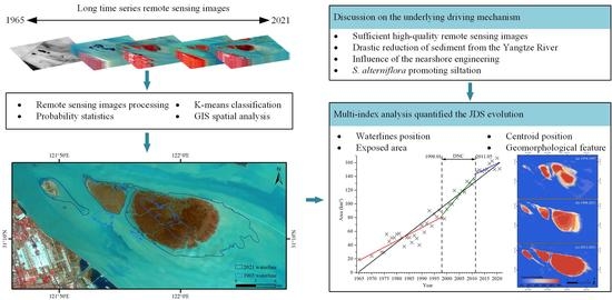
Detailed Processes of Tidal Flat Geomorphology Evolution Based on Time-Series Satellite Images
Abstract
:1. Introduction
2. Study Area
3. Data and Methods
3.1. Satellite Data and Pre-Processing
3.2. Methods
4. Results
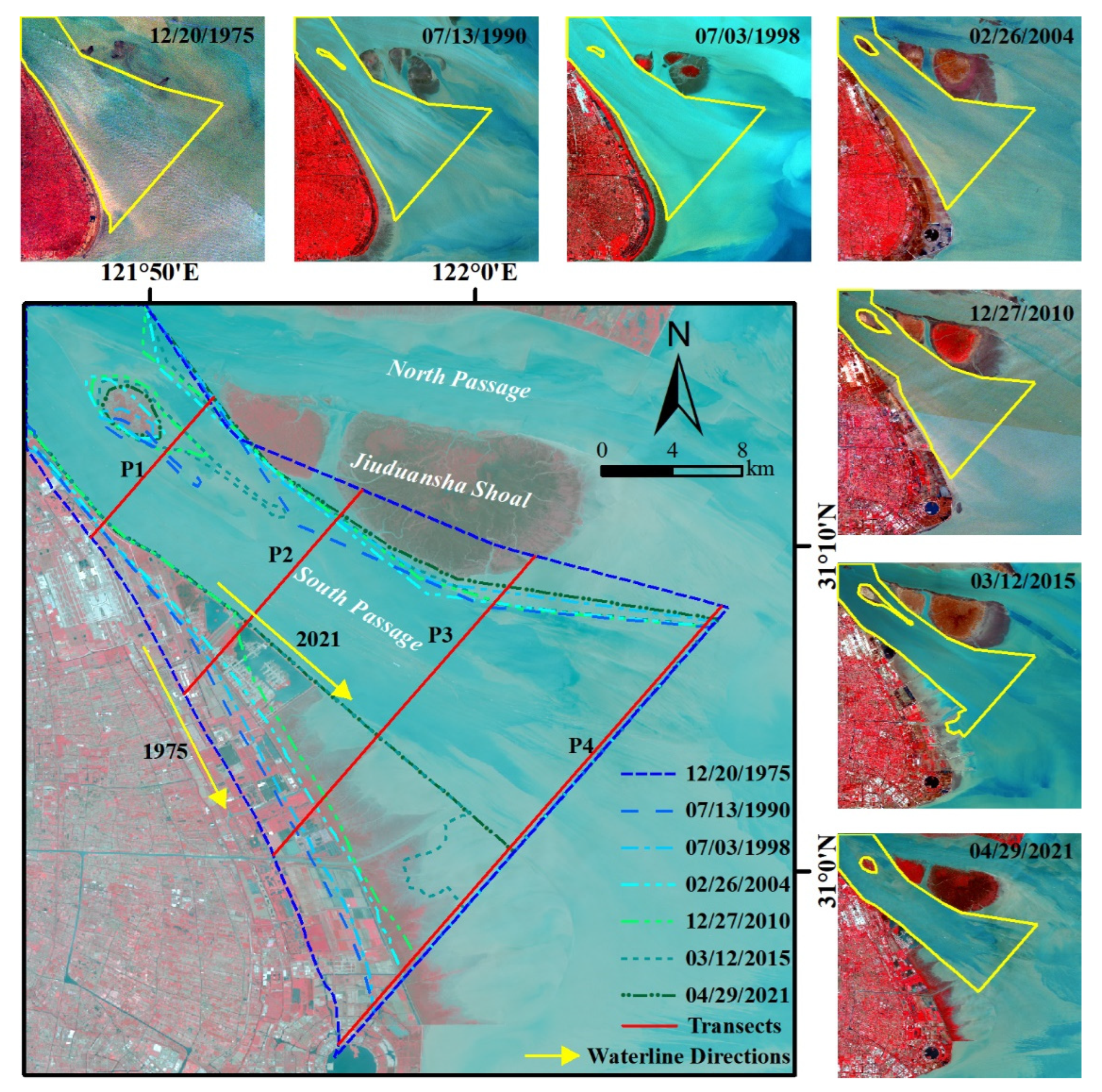
4.1. Waterlines Position Changes
4.2. Exposed Area Changes
4.3. Centroid Position Changes
4.4. Geomorphological Changes
5. Discussion
5.1. Sufficient High-Quality Remote Sensing Images and High-Precision Waterline Extraction
5.2. Sediment Sources
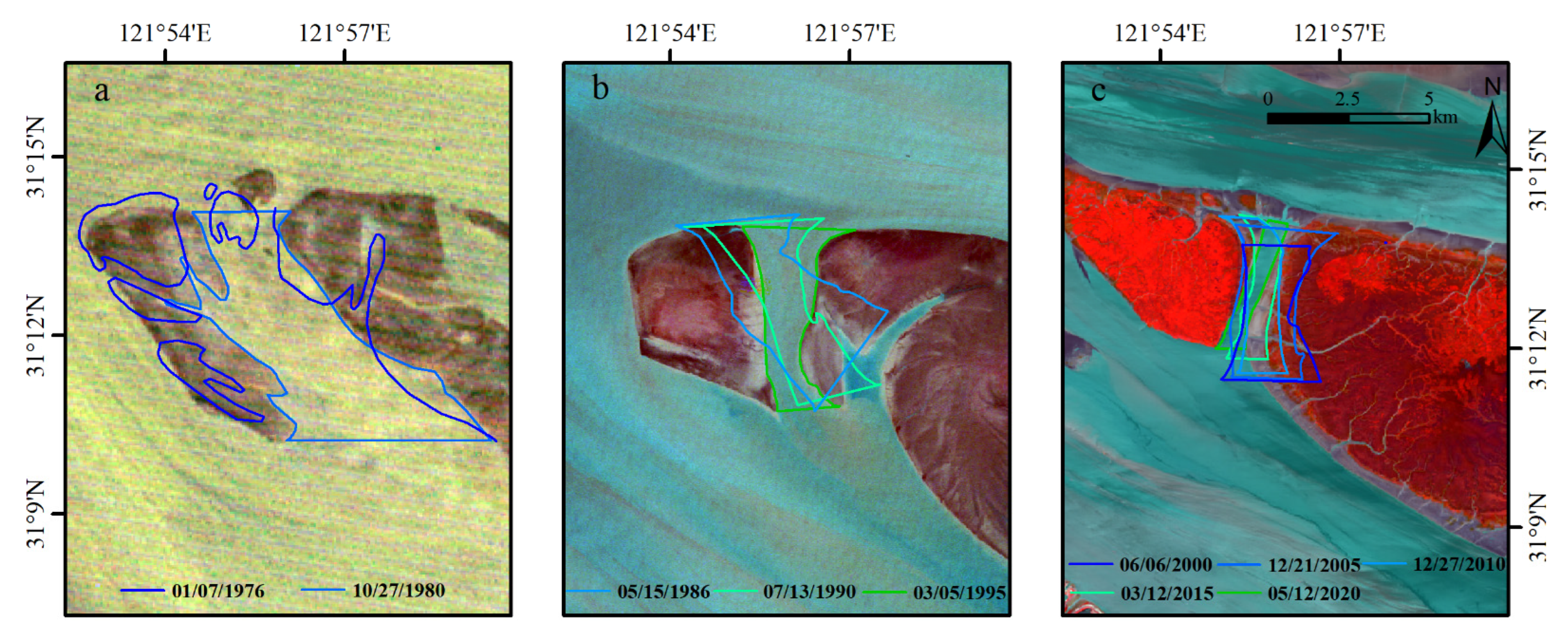
5.3. Influence of the Nearshore Engineering
5.3.1. DNC Project
5.3.2. Project Induced Large Tidal Creek Change
5.3.3. Nanhui Mudflat Reclamation
5.4. Ecological Engineering of Vegetation Planting
5.5. The Possible Evolution Trend in the Future
6. Conclusions
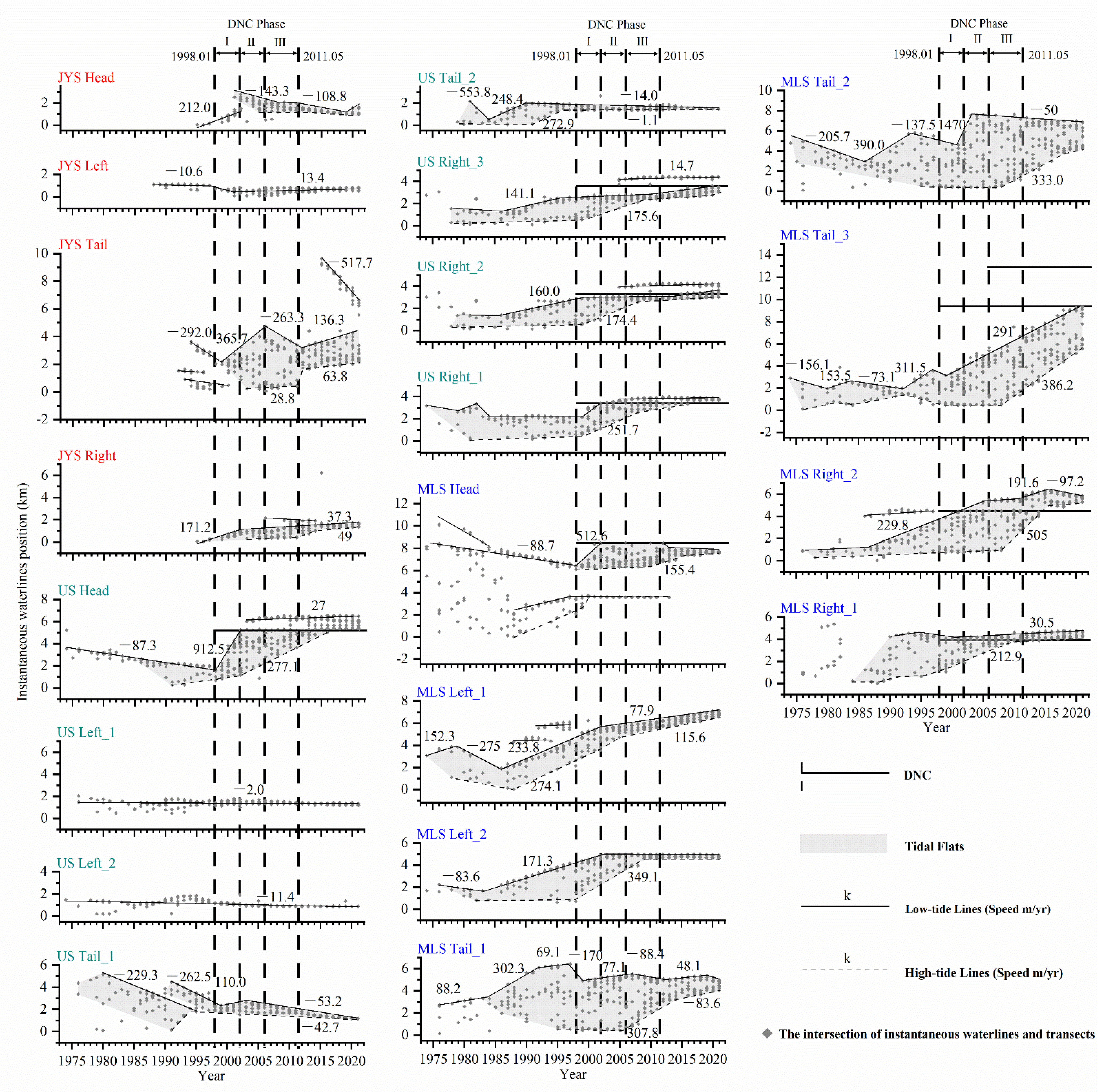
- In the past 60 years, the instantaneous waterline position of the JDS presented the characteristics of segmental and linear change;
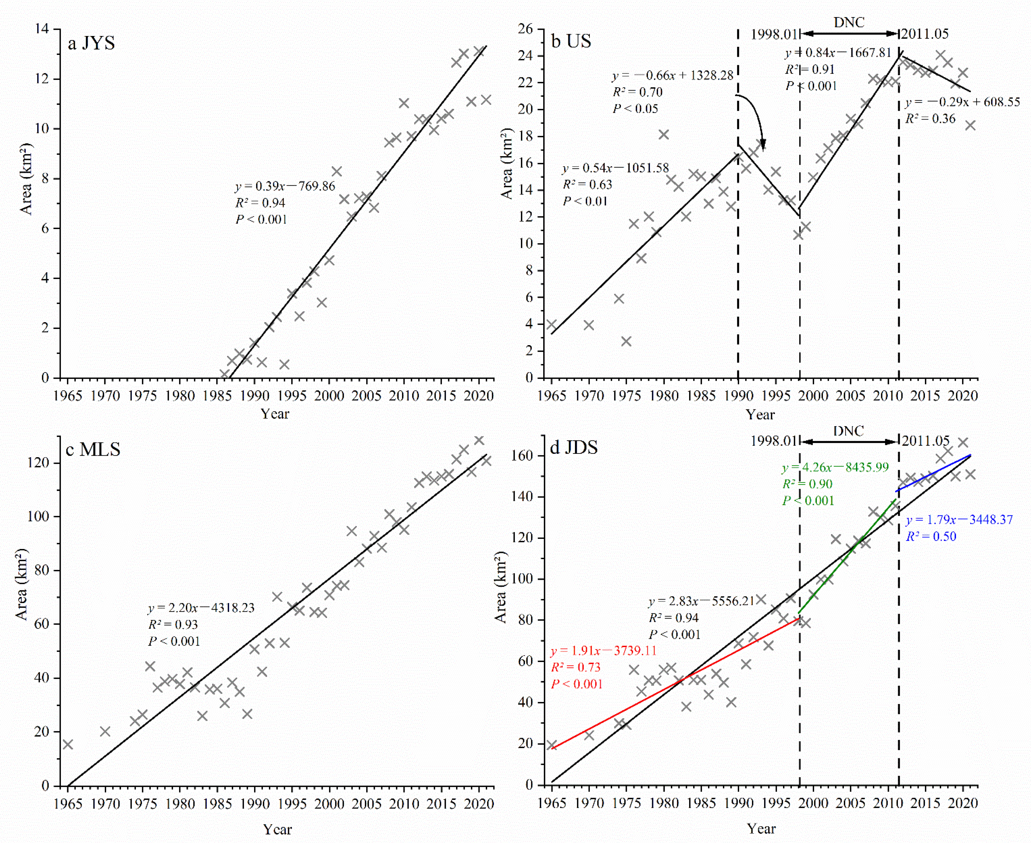
- Except for the exposed area of the Upper Shoal (US), which showed a decreasing trend between 1992–1998 and 2011–2021, the exposed areas of each shoal and the JDS overall showed a rapid growth trend;
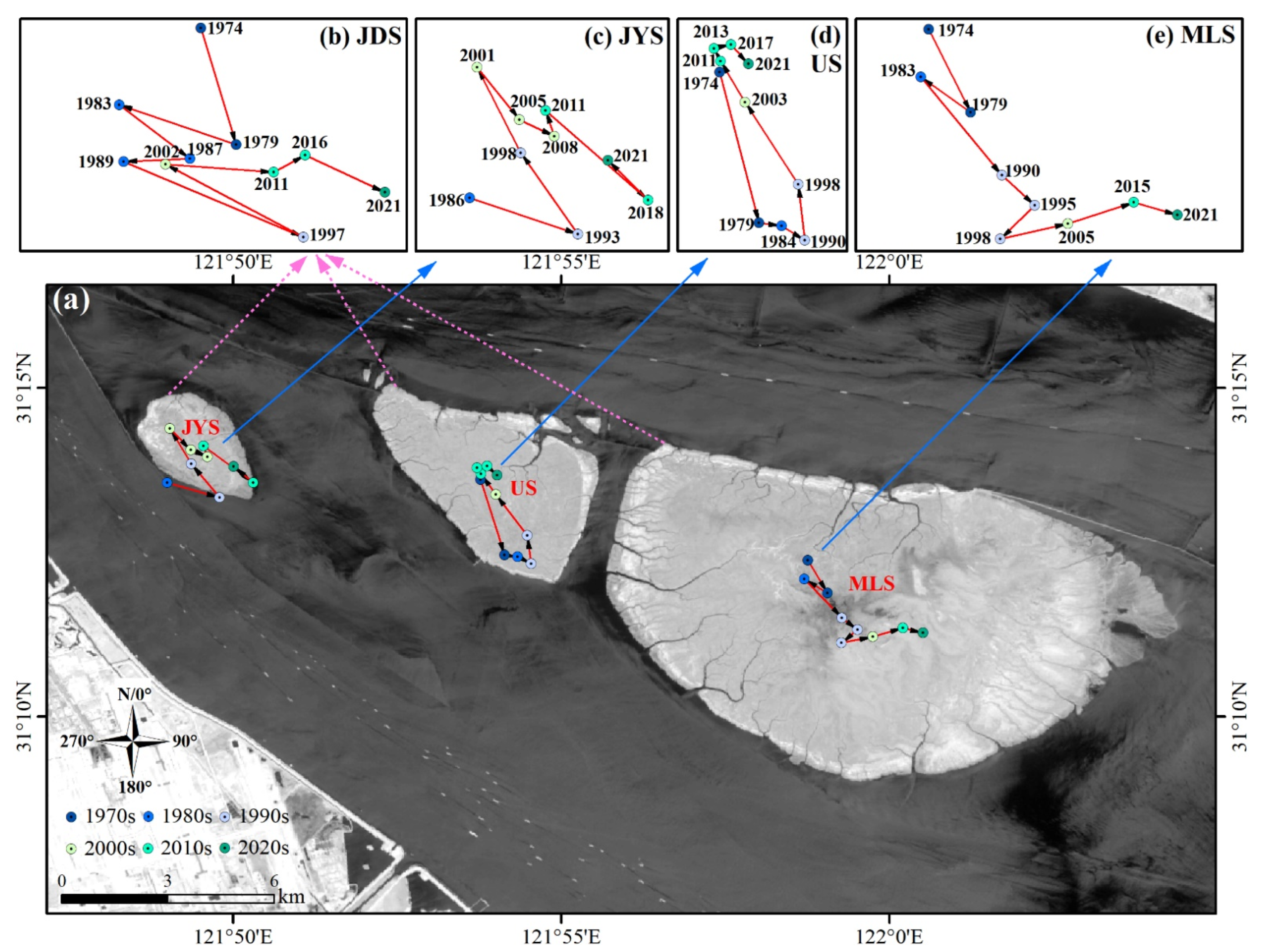
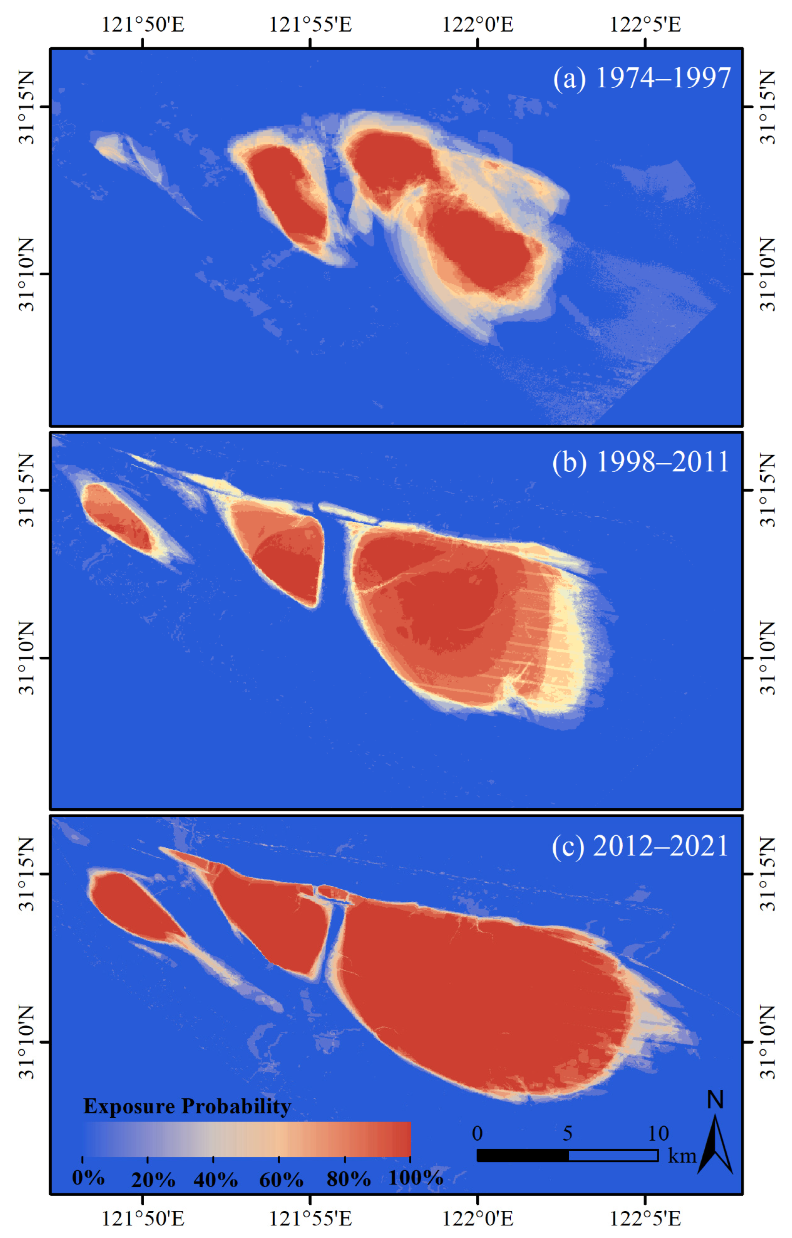
- During the early period between 1965–1998, the JDS presented a natural evolution state of “the head erosion, the tail deposition, and extending to the southeast”. During the recent period between 1999–2021, the evolution state changed to the engineering-dominated evolution state of “erosion on the south side, deposition on the north side, continuous extension to the southeast, and overall northward movement”;
- The accelerated deposition of JDS over the last 20 years has been mainly attributed to human activities, including the construction of Deep-water Navigation Channels and the vegetation promoting silting, followed by the upstream and downstream sediment sources;
- Current results suggest the US and the Middle-lower Shoal will merge under the continuous influence of estuary projects. The JDS would become more elongated in the southeast-northwest direction, but its south side will continue to erode. The JDS evolution should be paid attention to maintain the navigation of the deep-water channel and shoal stabilization.
Author Contributions
Funding
Data Availability Statement
Acknowledgments
Conflicts of Interest
Appendix A
| Abbreviation | Acronym | Abbreviation | Acronym | Abbreviation | Acronym |
|---|---|---|---|---|---|
| YRD | Yangtze River Delta | JYS | Jiangya Shoal | MSS | Multispectral Scanner |
| TGD | Three Gorges Dam | US | Upper Shoal | TM | Thematic Mapper |
| DNC | Deep-water Navigation Channels | MS | Middle Shoal | ETM+ | Enhanced Thematic Mapper Plus |
| SP | South Passage | LS | Lower Shoal | OLI | Operational Land Imager |
| NP | North Passage | MLS | Middle-Lower Shoals | GEE | Google Earth Engine |
References
- IPCC. Climate Change 2022: Mitigation of Climate Change; Cambridge University Press: Cambridge, UK, 2022. [Google Scholar]
- Church, J.A.; White, N.J. Sea-level rise from the late 19th to the early 21st century. Surv. Geophys. 2011, 32, 585–602. [Google Scholar] [CrossRef]
- Milliman, J.D.; Farnsworth, K.L. River Discharge to the Coastal Ocean: A Global Synthesis; Cambridge University Press: Cambridge, UK, 2011. [Google Scholar] [CrossRef]
- Anthony, E.J.; Marriner, N.; Morhange, C. Human influence and the changing geomorphology of Mediterranean deltas and coasts over the last 6000 years: From progradation to destruction phase? Earth-Sci. Rev. 2014, 139, 336–361. [Google Scholar] [CrossRef]
- Wu, W.T.; Yang, Z.Q.; Tian, B.; Huang, Y.; Zhou, Y.X.; Zhang, T. Impacts of coastal reclamation on wetlands: Loss, resilience, and sustainable management. Estuar. Coast. Shelf Sci. 2018, 210, 153–161. [Google Scholar] [CrossRef]
- Besset, M.; Anthony, E.J.; Bouchette, F. Multi-decadal variations in delta shorelines and their relationship to river sediment supply: An assessment and review. Earth-Sci. Rev. 2019, 193, 199–219. [Google Scholar] [CrossRef]
- Yang, S.L.; Luo, X.X.; Temmerman, S.; Kirwan, M.; Bouma, T.; Xu, K.H.; Zhang, S.S.; Fan, J.Q.; Shi, B.W.; Yang, H.F.; et al. Role of delta-front erosion in sustaining salt marshes under sea level rise and fluvial sediment decline. Limnol. Oceanogr. 2020, 65, 1990–2009. [Google Scholar] [CrossRef]
- Rangoonwala, A.; Jones, C.E.; Ramsey, E., III. Wetland shoreline recession in the Mississippi River Delta from petro-leum oiling and cyclonic storms. Geophys. Res. Lett. 2016, 43, 11–652. [Google Scholar] [CrossRef]
- Zhang, X.D.; Xie, R.; Fan, D.D.; Yang, Z.S.; Wang, H.M.; Wu, C.; Yao, Y.H. Sustained growth of the largest unin-habited alluvial island in the Changjiang Estuary under the drastic reduction of river discharged sediment. Sci. China Earth Sci. 2021, 64, 1687–1697. [Google Scholar] [CrossRef]
- Zhang, X.D.; Xu, K.H.; Yang, Z.S.; Tan, X.W.; Wu, C. Decreasing land growth and unique seasonal area fluctuations of two newborn Mississippi subdeltas. Geomorphology 2021, 378, 107617. [Google Scholar] [CrossRef]
- Zhao, Y.F.; Zou, X.Q.; Liu, Q.; Xu, M.; Yao, Y.L. Recent morphological changes of the Changjiang (Yangtze River) mega-delta in the Anthropocene, China: Impact from natural and anthropogenic changes. Holocene 2021, 31, 791–801. [Google Scholar] [CrossRef]
- Cao, W.Z.; Wong, M.H. Current status of coastal zone issues and management in China: A review. Environ. Ternational 2007, 33, 985–992. [Google Scholar] [CrossRef]
- Camacho-Valdez, V.; Ruiz-Luna, A.; Ghermandi, A.; Nunes, P.A. Valuation of ecosystem services provided by coastal wetlands in northwest Mexico. Ocean. Coast. Manag. 2013, 78, 1–11. [Google Scholar] [CrossRef]
- Costanza, R.; Anderson, S.J.; Sutton, P.; Mulder, K.; Mulder, O.; Kubiszewski, I.; Wang, X.T.; Liu, X.; Pérez-Maqueo, O.; Martinez, M.L.; et al. The global value of coastal wetlands for storm protection. Glob. Environ. Chang. 2021, 70, 102328. [Google Scholar] [CrossRef]
- Wu, J.G.; Huang, J.H.; Han, X.G.; Gao, X.M.; He, F.L.; Jiang, M.X.; Jiang, Z.G.; Primack, R.B.; Shen, Z.H. The three gorges dam: An ecological perspective. Front. Ecol. Environ. 2004, 2, 241–248. [Google Scholar] [CrossRef]
- Liang, Y.S.; Wang, W.; Li, H.J.; Shen, X.H.; Xu, Y.L.; Dai, J.R. The South-to-North Water Diversion Project: Effect of the water diversion pattern on transmission of Oncomelania hupensis, the intermediate host of Schistosoma japonicum in China. Parasites Vectors 2012, 5, 1–6. [Google Scholar] [CrossRef] [PubMed]
- Tan, Y.; Wang, Y.Q. Environmental migration and sustainable development in the upper reaches of the Yangtze River. Popul. Environ. 2004, 25, 613–636. [Google Scholar] [CrossRef]
- He, Q.; Wang, Y.Y.; Yu, Z.Y.; Liu, J. Sediment transport processes in deep water navigation channel, Yangtze estuary, China. Coast. Eng. 2006, 5, 3007–3018. [Google Scholar] [CrossRef]
- Li, X.; Liu, J.P.; Tian, B. Evolution of the Jiuduansha wetland and the impact of navigation works in the Yangtze Estuary, China. Geomorphology 2016, 253, 328–339. [Google Scholar] [CrossRef]
- Yang, S.L.; Belkin, I.M.; Belkina, A.I.; Zhao, Q.Y.; Zhu, J.; Ding, P.X. Delta response to decline in sediment supply from the Yangtze River: Evidence of the recent four decades and expectations for the next half-century. Estuar. Coast. Shelf Sci. 2003, 57, 689–699. [Google Scholar] [CrossRef]
- Gao, S. Modeling the growth limit of the Changjiang Delta. Geomorphology 2007, 85, 225–236. [Google Scholar] [CrossRef]
- Yang, S.L.; Milliman, J.D.; Li, P.; Xu, K. 50,000 dams later: Erosion of the Yangtze River and its delta. Glob. Planet. Chang. 2011, 75, 14–20. [Google Scholar] [CrossRef]
- Luan, H.L.; Ding, P.X.; Wang, Z.B.; Ge, J.Z.; Yang, S.L. Decadal morphological evolution of the Yangtze estuary in response to river input changes and estuarine engineering projects. Geomorphology 2016, 265, 12–23. [Google Scholar] [CrossRef]
- Tian, B.; Zhang, L.Q.; Wang, X.R.; Zhou, Y.X.; Zhang, W. Forecasting the effects of sea-level rise at Chongming Dongtan Nature Reserve in the Yangtze Delta, Shanghai, China. Ecol. Eng. 2010, 36, 1383–1388. [Google Scholar] [CrossRef]
- Wei, W.; Tang, Z.H.; Dai, Z.J.; Lin, Y.F.; Ge, Z.P.; Gao, J.J. Variations in tidal flats of the Changjiang (Yangtze) estuary during 1950s–2010s: Future crisis and policy implication. Ocean Coast. Manag. 2015, 108, 89–96. [Google Scholar] [CrossRef]
- Zhang, X.D.; Zhang, Y.X.; Zhu, L.H.; Chi, W.Q.; Yang, Z.S.; Wang, B.Y.; Lv, K.; Wang, H.M.; Lu, Z.Y. Spatial-temporal evolution of the eastern Nanhui mudflat in the Changjiang (Yangtze River) Estuary under intensified human activities. Geomorphology 2018, 309, 38–50. [Google Scholar] [CrossRef]
- Li, B.; Liao, C.H.; Zhang, X.D.; Chen, H.L.; Wang, Q.; Chen, Z.Y.; Gan, X.J.; Wu, J.H.; Zhao, B.; Ma, Z.J.; et al. Spartina alterniflora invasions in the Yangtze River estuary, China: An overview of current status and ecosystem effects. Ecol. Eng. 2009, 35, 511–520. [Google Scholar] [CrossRef]
- Shi, B.W.; Yang, S.L.; Wang, Y.P.; Li, G.C.; Li, M.L.; Li, P.; Li, C. Role of wind in erosion-accretion cycles on an estuarine mudflat. J. Geophys. Res. Ocean. 2017, 122, 193–206. [Google Scholar] [CrossRef]
- Wang, Y.; Liu, Y.; Jin, S.; Sun, C.; Wei, X. Evolution of the topography of tidal flats and sandbanks along the Jiangsu coast from 1973 to 2016 observed from satellites. ISPRS J. Photogramm. Remote Sens. 2019, 150, 27–43. [Google Scholar] [CrossRef]
- Shi, B.W.; Yang, S.L.; Wang, Y.P.; Yu, Q.; Li, M.L. Intratidal erosion and deposition rates inferred from field observations of hydrodynamic and sedimentary processes: A case study of a mudflat–saltmarsh transition at the Yangtze delta front. Cont. Shelf Res. 2014, 90, 109–116. [Google Scholar] [CrossRef]
- Choi, J.K.; Ryu, J.H.; Lee, Y.K.; Yoo, H.R.; Woo, H.J.; Kim, C.H. Quantitative estimation of intertidal sediment characteristics using remote sensing and GIS. Estuar. Coast. Shelf Sci. 2010, 88, 125–134. [Google Scholar] [CrossRef]
- Jiang, C.J.; Li, J.F.; de Swart, H.E. Effects of navigational works on morphological changes in the bar area of the Yangtze Estuary. Geomorphology 2012, 139–140, 205–219. [Google Scholar] [CrossRef]
- Zheng, J.H.; Peng, Y.X.; Zhang, C.; Ju, Y. Recent evolution of Jiuduansha Shoal in Yangtze Estuary and its corresponding to engineering projects. J. Coast. Res. 2013, 65, 1259–1264. [Google Scholar] [CrossRef]
- Ryu, J.H.; Kim, C.H.; Lee, Y.K.; Won, J.S.; Chun, S.S.; Lee, S. Detecting the intertidal morphologic change using satellite data. Estuar. Coast. Shelf Sci. 2008, 78, 623–632. [Google Scholar] [CrossRef]
- Yang, Z.H.; Wang, L.H.; Sun, W.W.; Xu, W.X.; Tian, B.; Zhou, Y.X.; Yang, G.; Chen, C. A New Adaptive Remote Sensing Extraction Algorithm for Complex Muddy Coast Waterline. Remote Sens. 2022, 14, 861. [Google Scholar] [CrossRef]
- Heygster, G.; Dannenberg, J.; Notholt, J. Topographic mapping of the German tidal flats analyzing SAR images with the waterline method. IEEE Trans. Geosci. Remote Sens. 2010, 48, 1019–1030. [Google Scholar] [CrossRef]
- Kang, Y.Y.; Ding, X.R.; Xu, F.; Zhang, C.K.; Ge, X.P. Topographic mapping on large-scale tidal flats with an iterative approach on the waterline method. Estuar. Coast. Shelf Sci. 2017, 190, 11–22. [Google Scholar] [CrossRef]
- Zhou, Y.Y.; Huang, H.Q.; Nanson, G.C.; Huang, C.; Liu, G.H. Progradation of the Yellow (Huanghe) River Delta in response to the implementation of a basin- scale water regulation program. Geomorphology 2015, 243, 65–74. [Google Scholar] [CrossRef]
- Cao, W.T.; Zhou, Y.Y.; Li, R.; Li, X.C. Mapping changes in coastlines and tidal flats in developing islands using the full time series of Landsat images. Remote Sens. Environ. 2020, 239, 111665. [Google Scholar] [CrossRef]
- Murray, N.J.; Clemens, R.S.; Phinn, S.R.; Possingham, H.P.; Fuller, R.A. Tracking the rapid loss of tidal wetlands in the Yellow Sea. Front. Ecol. Environ. 2014, 12, 267–272. [Google Scholar] [CrossRef]
- Sagar, S.; Roberts, D.; Bala, B.; Lymburner, L. Extracting the intertidal extent and topography of the Australian coastline from a 28 year time series of Landsat observations. Remote Sens. Environ. 2017, 195, 153–169. [Google Scholar] [CrossRef]
- Chander, G.; Markham, B.L.; Helder, D.L. Summary of current radiometric calibration coefficients for Landsat MSS, TM, ETM+, and EO-1 ALI sensors. Remote Sens. Environ. 2009, 113, 893–903. [Google Scholar] [CrossRef]
- Foga, S.; Scaramuzza, P.L.; Guo, S.; Zhu, Z.; Dilley Jr, R.D.; Beckmann, T.; Schmidt, G.L.; Dwyer, J.L.; Hughes, M.J.; Laue, B. Cloud detection algorithm comparison and validation for operational Landsat data products. Remote Sens. Environ. 2017, 194, 379–390. [Google Scholar] [CrossRef]
- Chen, Z.; Liu, L. Recent river regime evolution and navigation-obstructing characteristics of Jiangya south shoal in South Passage of the Yangtze estuary. Port Waterw. Eng. 2018, 3, 99–105, (In Chinese with English Abstract). [Google Scholar] [CrossRef]
- Thieler, E.R.; Himmelstoss, E.A.; Zichichi, J.L.; Ergul, A. The Digital Shoreline Analysis System (DSAS) Version 4.0-an ArcGIS Extension for Calculating Shoreline Change (No. 2008-1278); U.S. Geological Survey: Reston, VA, USA, 2009. [CrossRef]
- Almonacid-Caballer, J.; Sánchez-García, E.; Pardo-Pascual, J.E.; Balaguer-Beser, A.A.; Palomar-Vázquez, J. Evaluation of annual mean shoreline position deduced from Landsat 465 imagery as a mid-term coastal evolution indicator. Mar. Geol. 2016, 372, 79–88. [Google Scholar] [CrossRef]
- Salameh, E.; Frappart, F.; Turki, I.; Laignel, B. Intertidal topography mapping using the waterline method from Sentinel-1 &-2 images: The examples of Arcachon and Veys Bays in France. ISPRS J. Photogramm. Remote Sens. 2020, 163, 98–120. [Google Scholar] [CrossRef]
- Dai, Z.J.; Fagherazzi, S.; Mei, X.F.; Gao, J.J. Decline in suspended sediment concentration delivered by the Changjiang (Yangtze) River into the East China Sea between 1956 and 2013. Geomorphology 2016, 268, 123–132. [Google Scholar] [CrossRef]
- Yang, S.L. Sedimentation on a growing intertidal island in the Yangtze River mouth. Estuar. Coast. Shelf Sci. 1999, 49, 401–410. [Google Scholar] [CrossRef]
- Dai, Z.J.; Liu, J.T.; Wei, W.; Chen, J.Y. Detection of the Three Gorges Dam influence on the Changjiang (Yangtze River) submerged delta. Sci. Rep. 2014, 4, 6600. [Google Scholar] [CrossRef]
- Kang, Y.; He, J.; Wang, B.; Lei, J.; Wang, Z.; Ding, X. Geomorphic Evolution of Radial Sand Ridges in the South Yellow Sea Observed from Satellites. Remote Sens. 2022, 14, 287. [Google Scholar] [CrossRef]
- Zhan, C.; Yu, J.; Wang, Q.; Li, Y.; Zhou, D.; Xing, Q.; Chu, X. The evolutionary process of the geomorphology of tidal embayments in southern Jiaodong Peninsula, China. Estuar. Coast. Shelf Sci. 2017, 194, 182–191. [Google Scholar] [CrossRef]
- Mao, Z.C.; Guo, J.Q. Study on the collapse of upper Jiuduansha shoal and the effect of out-bar and inner channel. Ocean Eng. 2015, 33, 107–112, (In Chinese with English Abstract). [Google Scholar] [CrossRef]
- Yang, Z.H. Research on the Evolution of Erosion and Deposition in Jiuduansha of the Yangtze Estuary in the Past 60 Years Based on Remote Sensing Technology. Master’s Thesis, Chengdu University of Information Technology, Chengdu, China, 2022. [Google Scholar]
- Liu, M.Y.; Li, H.Y.; Li, L.; Man, W.D.; Jia, M.M.; Wang, Z.M.; Lu, C.Y. Monitoring the invasion of Spartina alterniflora using multi-source high-resolution imagery in the Zhangjiang Estuary, China. Remote Sens. 2017, 9, 539. [Google Scholar] [CrossRef]
- Peng, Z.Y.; Jiang, X.Z.; Hou, L.J.; He, Q. Comparison of suspended sediment and salinity profile characteristics of the maximum turbidity zone in the Yangtze estuary during the dry season in 1982 and 2012. Mar. Geol. Front. 2020, 36, 7–18, (In Chinese with English Abstract). [Google Scholar] [CrossRef]


| Shoal | Time | Direction (°) | Speed(m/yr) | Shoal | Time | Direction (°) | Speed(m/yr) |
|---|---|---|---|---|---|---|---|
| JDS | 1974–1979 | 160.06 | 236.85 | US | 1974–1979 | 162.56 | 438.58 |
| 1979–1983 | 285.82 | 300.96 | 1979–1984 | 96.71 | 65.39 | ||
| 1983–1987 | 122.77 | 217.25 | 1984–1990 | 117.90 | 63.41 | ||
| 1987–1989 | 267.47 | 324.38 | 1990–1998 | 351.98 | 99.09 | ||
| 1989–1997 | 109.36 | 238.03 | 1998–2003 | 322.43 | 276.38 | ||
| 1997–2002 | 293.93 | 304.52 | 2003–2011 | 324.57 | 84.45 | ||
| 2002–2011 | 93.09 | 117.74 | 2011–2013 | 327.99 | 100.66 | ||
| 2011–2016 | 64.89 | 69.46 | 2013–2017 | 78.69 | 61.12 | ||
| 2016–2021 | 111.32 | 171.61 | 2017–2021 | 132.71 | 121.15 | ||
| JYS | 1986–1993 | 105.55 | 190.24 | MLS | 1974–1979 | 148.93 | 207.20 |
| 1993–1998 | 320.13 | 231.96 | 1979–1983 | 300.68 | 170.75 | ||
| 1998–2001 | 328.57 | 375.60 | 1983–1990 | 135.59 | 202.87 | ||
| 2001–2005 | 136.06 | 197.88 | 1990–1995 | 127.57 | 99.73 | ||
| 2005–2008 | 111.57 | 150.28 | 1995–1998 | 229.64 | 178.67 | ||
| 2008–2011 | 337.83 | 105.70 | 1998–2005 | 78.55 | 110.49 | ||
| 2011–2018 | 126.21 | 227.05 | 2005–2015 | 74.05 | 77.32 | ||
| 2018–2021 | 309.35 | 219.44 | 2015–2021 | 103.24 | 83.97 |
| Satellite Date | 20 December 1975 | 13 July 1990 | 3 July 1998 | 26 February 2004 | 27 December 2010 | 12 March 2015 | 29 April 2021 | |
|---|---|---|---|---|---|---|---|---|
| Profiles | ||||||||
| P1 | 9.68 | 9.12 | 9.26 | 8.45 | 8.40 | 8.26 | 8.80 | |
| P2 | 14.50 | 9.45 | 10.22 | 9.56 | 8.14 | 7.50 | 7.68 | |
| P3 | 21.31 | 15.84 | 16.58 | 14.49 | 13.90 | 9.50 | 10.59 | |
| P4 | 31.23 | 26.91 | 27.35 | 24.63 | 23.47 | 19.82 | 16.34 | |
| Average | 19.18 | 15.33 | 15.85 | 14.28 | 13.48 | 11.27 | 10.85 | |
Publisher’s Note: MDPI stays neutral with regard to jurisdictional claims in published maps and institutional affiliations. |
© 2022 by the authors. Licensee MDPI, Basel, Switzerland. This article is an open access article distributed under the terms and conditions of the Creative Commons Attribution (CC BY) license (https://creativecommons.org/licenses/by/4.0/).
Share and Cite
Wang, L.; Yang, Z.; Sun, W.; Fan, L.; Tan, B.; Zhou, Y. Detailed Processes of Tidal Flat Geomorphology Evolution Based on Time-Series Satellite Images. Remote Sens. 2022, 14, 4341. https://doi.org/10.3390/rs14174341
Wang L, Yang Z, Sun W, Fan L, Tan B, Zhou Y. Detailed Processes of Tidal Flat Geomorphology Evolution Based on Time-Series Satellite Images. Remote Sensing. 2022; 14(17):4341. https://doi.org/10.3390/rs14174341
Chicago/Turabian StyleWang, Lihua, Ziheng Yang, Weiwei Sun, Li Fan, Benhua Tan, and Yunxuan Zhou. 2022. "Detailed Processes of Tidal Flat Geomorphology Evolution Based on Time-Series Satellite Images" Remote Sensing 14, no. 17: 4341. https://doi.org/10.3390/rs14174341
APA StyleWang, L., Yang, Z., Sun, W., Fan, L., Tan, B., & Zhou, Y. (2022). Detailed Processes of Tidal Flat Geomorphology Evolution Based on Time-Series Satellite Images. Remote Sensing, 14(17), 4341. https://doi.org/10.3390/rs14174341


