Abstract
X-band KOMPSAT-5 provides a good perspective for soil moisture retrieval at high-spatial resolution over arid and semi-arid areas. In this paper, an intercomparison of KOMPSAT-5 and C-band Sentinel-1 radar data in soil moisture retrieval was conducted over agricultural fields in Wimmera, Victoria, Australia. Optical images from Sentinel-2 were also used to calculate the scattering contribution of vegetation. This study employed a new semi-empirical vegetation scattering model with a linear association of soil moisture with observed backscatter coefficient and vegetation indices. The Combined Vegetation Index (CVI) was proposed and first used to parameterize vegetation water content. As a result, the vegetation scattering model was developed to monitor soil moisture based on remotely sensed data and ground measurements. Application of the algorithm over dryland wheat field sites demonstrated that the estimated satellite-based soil moisture contents have good linear relationships with the ground measurements. The correlation coefficients (R) are 0.862 and 0.616, and the root mean square errors (RMSEs) have the values of 0.020 cm3/cm3 and 0.032 cm3/cm3 at X- and C-bands, respectively. Furthermore, the validation results also indicated that X-band provided higher consistent accuracy for soil moisture inversion than C-band. These results showed significant promise in retrieving soil moisture using KOMPSAT-5 and Sentinel-1 remotely sensed data at high-spatial resolution over agricultural fields, with subsequent uses for crop growth and yield estimation.
1. Introduction
Soil moisture is a fundamental environmental variable in the global energy, carbon and water exchange. It is of great relevance for many studies, such as crop yield estimation, drought monitoring, evapotranspiration and agricultural management. However, it is difficult to obtain accurate soil moisture that represents large areas and capture its local-to-regional variability using conventional ground-sensor based methods. Soil moisture during the growing season is an important parameter for agricultural practice and management decisions in arid and semi-arid regions [1]. Meanwhile, spatial and temporal soil moisture estimation is critical for agricultural and hydrological applications. Several studies and modeling have been proposed to explore the mechanisms of spatiotemporal variability of soil moisture [2,3,4]. The coefficient of spatial variation of soil moisture (CV) has been widely used to identify external control on spatiotemporal variability and stability of soil moisture, which has an inverse relationship with the mean temporal soil moisture. However, multi-temporal remotely sensed data and field observations are needed to capture the spatiotemporal variability of soil moisture. In recent years, there has been prolonged drought and a rash of deadly bushfires related to surface soil moisture and fuel moisture in Australia. Therefore, monitoring soil moisture effectively is important for assessing drought and guiding cropping decisions in Australia.
Synthetic aperture radar (SAR) has been used successfully in soil moisture estimation over agricultural regions. It can reveal the important feature of both bare and vegetated surface. Nowadays, many SARs operating at C, L and X-bands have been applied for agricultural monitoring. However, most studies of soil moisture retrieval at regional scale focus on the applications of C- and L-band SAR sensors [5,6,7]. So far, as an X-band SAR satellite, KOMPSAT-5 SAR images have been widely used in sea ice mapping [8,9,10], ship detection [11,12,13,14], land cover classification [15], disaster situations such as earthquakes [16], flooding [17,18,19] and marine oil spills [20,21,22]. Few studies have used KOMPSAT-5 for soil moisture estimation and comparative studies using X-band data are still in great demand.
For soil moisture retrieval over bare soil cover, particularly sparsely or lightly vegetated lands where X-band may present utility for mapping surface soil moisture, surface roughness is the main variable affecting soil moisture estimation accuracy using SAR observations. Many empirical and semi-empirical scattering models have been developed to reproduce radar backscatter coefficients based on soil moisture and surface roughness [23,24,25,26,27]. However, for dense vegetated regions, these models would only reproduce the soil component of the total scattering, while the vegetation canopy structure is typically also a key mechanism. Thus, many vegetation scattering methods have been proposed to obtain the total backscattering by combining scattering contributions of vegetation and underlying soil over densely vegetated cover [28,29,30,31].
The water-cloud model (WCM) was developed for predicting vegetation backscattering and has been widely applied in soil moisture retrieval [31]. Liu et al. [32] combined Oh model and WCM to obtain soil moisture using L-band SAR observations, which resulted in the RMSE < 2 dB and the correlation coefficient >0.6. Li et al. [33] investigated the feasibility of vegetation descriptors in WCM and yielded soil moisture retrievals with a correlation coefficient of 0.59 and an RMSE of 0.069 cm3/cm3. Wang et al. [34] used vegetation descriptors obtained from L-band radar data to parameterize WCM and monitor soil moisture. The results showed that the overall accuracy of retrieved soil moisture was promising with unbiased RMSE of 0.056, 0.053, 0.098 and 0.079 cm3/cm3 for canola, corn, bean and wheat, respectively. In order to optimize parameters in WCM and improve the accuracy of soil moisture estimation, many modified and calibrated models based on WCM have been developed by introducing various vegetation indices to represent the effect of vegetation on total scattering more precisely. Dabrowska-Zielinska et al. [35] applied a modified WCM with the least squares method to construct a newly developed model based on study of the effect of vegetation backscattering under different vegetation indices and soil moisture values. The most significant relationship was found for data with the lowest incidence angle, acquired from the ascending tracks of Sentinel-1 satellite in the Biebrza Wetlands, situated in north-eastern Poland. The soil moisture estimation for wetlands showed a reasonable accuracy (10 vol.%), which is several times higher than in agricultural areas. Rawat et al. [36] investigated a modified WCM using crop coefficients by minimizing the RMSE between observed and simulated backscatter coefficients in VV polarization. EVI (Enhanced Vegetation Index) and NDVI (Normalized Difference Vegetation Index) were treated as vegetation descriptors and used for the parametrization of vegetation and soil coefficients of modified WCM. Comparison between observed and simulated backscatter coefficients in VV polarization showed strong R2 and low RMSE with the combined use of NDVI and EVI.
Tao et al. [37] proposed a modified vegetation backscattering model by considering scattering influences of the vegetation canopy and underlying bare soil using RADARSAT-2 SAR data and field measurements. A vegetation parameter named vegetation coverage, which can be calculated from NDVI, was introduced into the modified backscattering model to effectively estimate the scattering mechanisms of vegetation. The modified model performed well with R2 of 0.806 and RMSE of 0.043 cm3/cm3.
However, in WCM or other modified models, the exact expression of soil moisture retrieval is difficult to solve mathematically due to the complex relationship between vegetation parameters, soil moisture and total backscatter coefficient. Thus, nowadays, statistical methods such as change detection and machine learning approaches are widely used to implement the retrieval processes [38,39,40,41]. The change detection algorithm was first proposed by Wagner et al. to estimate temporal soil moisture over vegetated regions [38]. NDVI has been used to represent the scattering influences of vegetation on the SAR signal. Although this simple method can reduce the impact of input parameter uncertainty effectively, surface roughness still strongly affects the minimum backscatter coefficient. The method is more suitable for grassland cover with constant roughness. The machine learning approaches such as artificial neural networks (ANNs) and ensemble learning have become a popular tool for implementing flexible inversion algorithms and have been widely used to address many retrieval problems in the soil moisture retrieval from SAR observations [39,42,43]. However, a large number of simulated datasets for training the ANNs are needed to obtain the best retrieval accuracy.
In this work, we propose a new vegetation scattering model and make it more accurate to retrieve soil moisture using the SAR and optical data under wheat-covered conditions in the study area. This model is derived from a modified backscattering model proposed by Tao et al. [37] and a numerical relationship between soil moisture and radar signal is obtained. A new vegetation index is proposed to obtain the scattering contributions of the wheat canopy in the total backscattering. Soil moisture contents estimated from KOMPSAT-5 and Sentinel-1a/b are evaluated against ground-based soil moisture measurements over agricultural fields. The spatial distribution of estimated soil moisture over the wheat field is generated from the SAR images.
2. Study Area and Datasets
2.1. Description of Study Area
The experimental area is located in a relatively flat region in the Wimmera, western Victoria, Australia (Figure 1). It has a Mediterranean climate with significant climatic characteristics of dry summers and rainy winters. It is a semi-arid zone covering very large agricultural regions. The temperature typically ranges from 14 to 30 °C. Grains are the main crop of the region and they usually grow from May to late November. Lighter sandy and sandy loam soils are the main soil textures in the study area and the majority of soils are used to support agricultural productions.
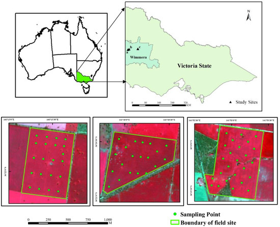
Figure 1.
Study area located in Wimmera, Victoria, Australia.
2.2. Satellite Data Collection and Preprocessing
2.2.1. KOMPSAT-5 SAR Data
KOMPSAT-5, known as Arirang 5, is the first Korean X-band SAR satellite based on the Korea National Space Program, which was launched in 2014 and operates between an altitude of 500 km to 600 km. KOMPSAT-5 acquires images in three different modes with varying qualities: standard, high resolution and wide swath modes. KOMPSAT-5 images collected in standard mode were used in this work.
In this study, KOMPSAT-5 images obtained on 19 September 2019 in HH polarization and 22 September 2019 in VV polarization, 2019 were used (See Table 1). The images are resampled to 3 m and the incidence angle is approximately 40°. Preprocessing procedures including radiometric calibration, terrain correction and speckle filtering to transform the raw digital number (DN) into the sigma naught in dB and to get the speckle noise reduced using filtering methods.

Table 1.
List of configurations and acquisition time of satellites.
2.2.2. Sentinel-1 SAR Data
C-band Sentinel-1 is designed by the European Space Agency (ESA) onboard the Copernicus mission. It provides images of 10-m resolution with the central frequency of 5.405 GHz. Both co- and cross-polarized backscatter are provided and the temporal revisit time of one satellite is 12 days, resulting in the repeat cycle of 6 days by the constellation. As a microwave sensor, the Sentinel-1 also provides all-weather, all-day images with global coverage and these data have been extensively used for ice sheet observations [44], land cover mapping [45], crop monitoring [46,47], ship detection [48], flood and earthquake applications [49,50], and soil moisture monitoring [41,51,52,53,54].
In order to ensure that the acquisition time of remotely sensed data is synchronized with the field observations, the Sentinel-1 data on 15 September 2019 were selected (Table 1) and freely downloaded through the Copernicus Open Access Hub (https://scihub.copernicus.eu/). The incidence angle of the acquired Sentinel-1 data is also about 40°. Sentinel-1 data were preprocessed including radiometric correction, terrain correction, speckle noise filtering using Lee filter and projection transformation to reduce the effect of local spatial heterogeneity.
2.2.3. Sentinel-2 Optical Data
Sentinel-2 is a two-satellite constellation with 13 spectral bands. It offers three kinds of optical data with the spatial resolutions of 10-m, 20-m and 60-m and provides full and systematic coverage of land surfaces.
Considering the coincident sampling with Sentinel-1 and clear-sky condition, the Sentinel optical data on 11 September 2019 were selected to monitor the scattering effects of vegetation with the spatial resolution of 10 m and resampled 3 m (See Table 1). The image was preprocessed for radiometric calibration and atmospheric correction using the atmospheric correction module (Sen2Cor).
2.3. Field Measurements
The field campaign in the three field sites was conducted simultaneously with the SAR satellites overpass from 17 to 20 September 2019 to collect soil surface temperature, wheat height and soil moisture content for each sampling location in the experimental field. The wheat was in the flowering growing stage with relatively high biomass. Each point was distributed uniformly and typically in each field. Volumetric soil moisture content was taken using a Theta probe and averaged using five measurements for each sampling location (four vertices and center point of the sampling square). Soil and wheat samples were processed in drying oven at 105 °C for 24 h (soil) and 65 °C for 48 h (vegetation) to get the gravimetric soil moisture and the vegetation water content. The measured soil moisture contents of the three field sites are shown in Figure 2, where the measured soil moisture contents in Site c# are apparently lower but have a wide value range, while the values in Site b# have a relatively concentrated distribution. The average values of soil moisture are 0.265 (Site a#), 0.247 (Site b#) and 0.114 cm3/cm3 (Site c#), respectively. Site c# has low values of measured soil moisture due to the sandy soil texture, while more loam soils are distributed in site a# and b#. Roughness parameters including surface RMS (root mean square) height and correlation length were observed using a custom-built roughness profiler, a 2-m-long panel with 200 pins digitized at a 0.5-cm interval. Each roughness profile was recorded as photographs and digitalized to obtain a profile contour curve for each location. Values of RMS height and correlation length were extracted from the digitized curve using compiled programs in IDL (Interactive Data Language). Two measurements of roughness parameters (measured in the east-west, south-north directions, alternatively) are obtained as the final value in each sampling point. The RMS height has the values ranging from 0.62 to 1.18 cm with the average value of 0.89 cm. The low and high values corresponded to sown and ploughed fields, respectively. The correlation length had the average value of 24.69 cm with a minimum of 9.55 cm and a maximum of 32.47 cm.
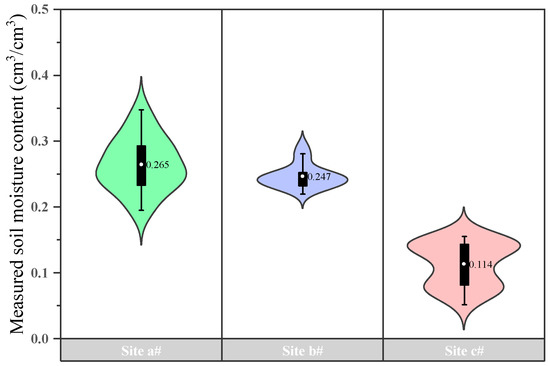
Figure 2.
Violin diagram of soil moisture contents measured in the field campaign (The unit of average soil moisture content is cm3/cm3).
3. Methods
Overall procedure of soil moisture retrieval in the vegetated regions is based on remotely sensed SAR and optical data are illustrated in the flowchart of Figure 3. From the flowchart, the whole retrieval scheme is given as follows:
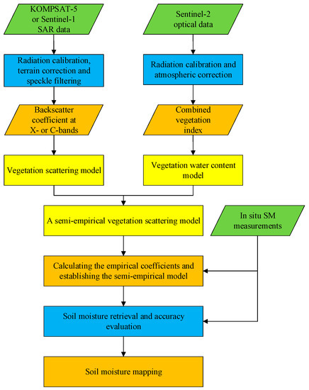
Figure 3.
Flowchart for soil moisture retrieval in vegetation-covered regions based on remotely sensed SAR and optical data.
Step 1: The two SAR data were preprocessed, and the observed backscatter coefficient was obtained from the processed images for soil moisture estimation at X- and C-bands. The Sentinel-2 optical data were also preprocessed to calculate the vegetation indices. The values of backscatter coefficient and vegetation indices were extracted for each sampling point.
Step 2: A semi-empirical model was developed according to the vegetation scattering model proposed by Tao et al. [37]. The original forest scattering model was modified by substituting the expressions of parameters using empirical equations [55]. The parameters include vegetation water content (VWC) and backscatter coefficient of bare soil. A new vegetation index was used to describe the VWC.
Step 3: Based on the extracted remotely sensed data and ground measurements, the semi-empirical model was constructed and the optimal coefficients were derived using the least squares regression. Then, soil moisture retrieval at X- and C-bands was conducted and mapped in the study area.
3.1. Herbaceous Vegetation Backscattering Model
Saatchi and Moghaddam developed a forest backscattering model for depicting the biometric characteristics and geometric distribution of forest canopy [55]. Three components are included in this model: crown, crown-ground and trunk-ground volume scattering. So, this model can be expressed as follows:
where, , and are the crown, crown-ground and trunk-ground backscattering, respectively. p and q represent horizontal or vertical polarization.
The three scattering components can be expressed in the following equations [55]:
where, means the wave number. is the dielectric constant of water, and represent the real and imaginary part of dielectric constant. is crown water content, which is same as VWC. is trunk water content. is incidence angle. means the RMS height. , , , and are structural coefficients. is surface Fresnel reflectivity, which has a logarithmic relationship with backscatter coefficient of bare soil [56].
However, this forest scattering model cannot be directly applied to characterize scattering mechanisms and structural parameters of herbaceous vegetation. Thus, Tao et al. proposed a herbaceous vegetation backscattering model (HVBM) by eliminating the trunk-ground scattering component in the forest model [37]. HVBM was developed to provide solutions for the volume scattering from vegetation and bare soil. It considers the vegetation layer as a collection of homogeneous spherical particles and ignores the multiple scattering effects between vegetation and underlying surface. The crown-ground scattering part can be rewritten as follows:
3.2. Combined Vegetation Index
In HVBM, the VWC is a key variable and could aid in yield estimation and irrigation decisions. Many vegetation indices such as NDVI and NDWI (Normalized Difference Water Index) are used to parameterize the estimation of VWC [57,58]. The equations of NDVI and NDWI are listed in Table 2 [59,60]. Although NDVI is sensitive to biomass and can effectively eliminate the effects of soil background and topographic changes, it is prone to saturation points, which can cause biomass estimation bias and reduce the accuracy of soil moisture retrieval [61]. Compared with NDVI, NDWI can better estimate vegetation moisture content, but it lacks the perception of atmospheric effects and so the inversion accuracy will be affected in soil moisture retrieval.

Table 2.
The vegetation indices and related equations used in this paper.
In this study, a new vegetation index called combined vegetation index (CVI) is proposed to estimate the value of VWC from the optical remotely sensed data. The CVI combines the near-infrared band in the high-reflection area of the vegetation canopy, the red band in the high-absorption area of chlorophyll, and the green band in the water absorption range, taking into account the sensitivity of vegetation greenness and leaf liquid water [62], which can be expressed as follows:
where, , and are the radiances at the green, red and near infrared bands, respectively.
3.3. Soil Moisture Retrieval Model
Studies also showed that backscatter coefficient of bare soil has a good linear correlation with soil moisture [63,64]. In order to build the linear relationship between backscatter coefficient and soil moisture over vegetated regions using HVBM, the exponential function in Equations (2) and (5) can be expressed as a polynomial following the Taylor approximation. For example, the exponential part of Equations (2) can be expressed as:
Combining Equations (1), (2), (5) and (7) yields:
According to the paper [55], the dielectric constants of water are given from mixing models at various frequencies. Thus, soil moisture content can be written as follows:
where, means soil moisture content. has a linear relationship with CVI and related vegetation indices [65]. ~ are empirical parameters.
Bao et al. [66] also proposed an empirical model using WCM and NDWI, which is expressed as follows:
where, represents NDWI. ~ are empirical parameters. Tao et al. [67] used Bao’s model to evaluate the applicability of X-band SAR data in soil moisture retrieval over dryland wheat fields. However, the study indicated that the numerical expression between total backscatter coefficient, soil moisture and vegetation parameters in Bao’s model could not be directly derived from the WCM. The presence of NDWI up to the 4th power seems difficult to understand and suggests that NDWI has more weight than backscattering in computing SM, which is contrasting with the physics.
4. Results
In this study, the proposed new model was used to retrieve soil moisture based on KOMPSAT-5 and Sentinel-1 SAR data. Sixty-five ground soil moisture samples were obtained in the field work. Forty-three samples were used to calculate the empirical coefficients and the remaining samples were applied to evaluate the estimation accuracy of soil moisture. The correlation coefficient (R) and RMSE were used to evaluate the estimated accuracy of soil moisture. In Table 3, the empirical coefficients of the proposed model and Bao’s model were calculated using the ground measurements and SAR data at X- and C-bands.

Table 3.
Empirical coefficients used in the proposed model and Bao’s model.
In order to obtain the optimal polarization for soil moisture retrieval, the inversion results from Sentinel-1 VV and VH polarization data were shown in Figure 4. The results demonstrated that the accuracy in VV polarization was obviously higher than that from VH polarization data (VH: R = 0.552, RMSE = 0.035 cm3/cm3; VV: R = 0.706, RMSE = 0.037 cm3/cm3). Thus, the VV polarization SAR data were used to monitor soil moisture in this study.
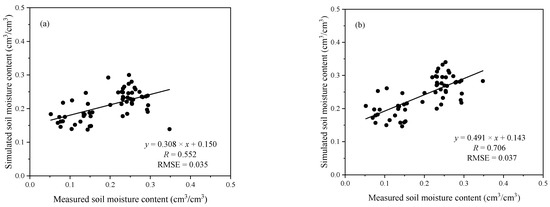
Figure 4.
Scatter plot between the measured soil moisture and simulated soil moisture in VH (a) and VV (b) polarization at C-bands using the semi-empirical model (The units of RMSE is cm3/cm3).
Meanwhile, in order to obtain the optimal combination method of soil moisture retrieval based on the proposed model, this paper applied the Sentinel-2 optical data to calculate three vegetation indices NDVI, NDWI and CVI, combined with the VV extracted from the KOMPSAT-5 SAR images. Three kinds of inversion combinations composing of three vegetation indices and VV polarization were carried out to evaluate the effectiveness of the semi-empirical model. The comparison results of the soil moisture retrieval accuracy under the three combined methods of the model developed in this paper are shown in Table 4. In the three combined inversion methods, the CVI and VV polarization combination method has the highest R and the lowest RMSE, which is the optimal combination way for the application of the semi-empirical model developed in this paper.

Table 4.
Comparison results of soil moisture inversion accuracy under the three combined inversion methods of the model developed in this paper.
The proposed semi-empirical model described in Equation (9) was applied to C- and X-band SAR data to estimate surface soil moisture. In this study, 43 samples were employed as the calibration data to perform the parameterization of the model. The comparison between the simulated soil moisture and the in situ soil moisture is presented in Figure 5. Soil moisture was retrieved based on KOMPSAT-5 at X-band and Sentinel-1 at C-band based on Equation (9). From the estimated result in Figure 5, the estimated accuracy at X-band is better than that at C-band. The RMSEs at X- and C-bands were 0.037 and 0.036 cm3/cm3, and the R were 0.803 and 0.634, respectively.
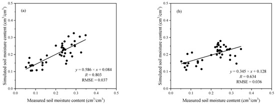
Figure 5.
Scatter plot between the measured and simulated soil moisture at X- (a) and C-bands (b) using the semi-empirical model based on calibration data (The units of RMSE is cm3/cm3).
Then, a validation experiment was conducted to further evaluate the accuracy of the proposed model using the other 22 sampling points. As shown in Figure 6, a good linear relationship between the retrieved soil moisture and measurements. The R were 0.862 and 0.616, and the RMSEs were 0.020 cm3/cm3 and 0.032 cm3/cm3 at X-band (Figure 6a) and C-bands (Figure 6c) based on the proposed model, respectively. Compared with Bao’s model at X- (R = 0.819, RMSE = 0.028 cm3/cm3) in Figure 6b and C-bands (R = 0.680, RMSE = 0.031 cm3/cm3) in Figure 6d, the proposed model has a significant improvement with the slightly higher R. The results demonstrated that the proposed model could monitor soil moisture accurately using X- and C-bands SAR data in the agricultural regions. Meanwhile, the estimated accuracy of soil moisture from KOMPSAT-5 data using the proposed model was a little higher than that using Bao’s model, while the result was just the opposite from Sentinel-1 data. A possible reason for this result is that the CVI in the proposed model can effectively monitor the volume scattering of vegetation canopy and improve the estimated accuracy of soil moisture using X-band SAR data.
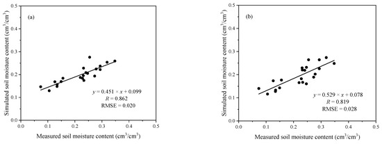
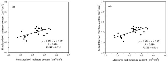
Figure 6.
Scatter plot between the measured and retrieved soil moisture at X- (a) and C-bands (c) using the semi-empirical model vs at X- (b) and C-bands (d) using Bao’s model based on validation data (The units of RMSE is cm3/cm3).
In addition, X- and C-bands SAR data were used to generate the spatial distribution of soil moisture over the three wheat fields in Figure 7. Overall, soil moisture at X- and C-bands both present uniformly distribution although they have different spatial resolutions. For Site a# and c#, the X-band has little larger values than C-band. The estimated soil moisture contents using X-band SAR data over most parts of Site c# range from 0.01 to 0.20 cm3/cm3. Only small areas in the north and south of the study area have the values of above 0.30 cm3/cm3. For site a#, from the values of soil moisture retrieval using X- and C- bands SAR data in Figure 7a,b, the field is relatively wetter than that in Site c# and the estimated soil moisture is above 0.20 cm3/cm3. The red circle is a pond for the irrigation. For Site b#, the result from C-band has slightly higher values than X-band especially in the western regions. Thus, the proposed semi-empirical model can perform well and retrieve highly consistent soil moisture values with ground measurements.
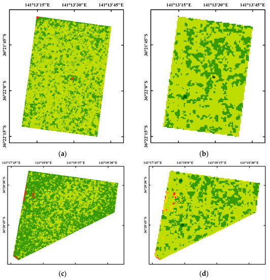
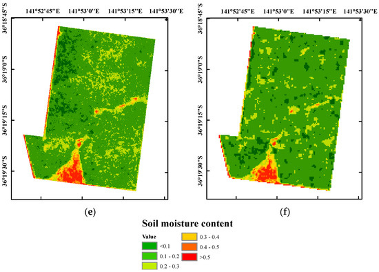
Figure 7.
Map of soil moisture retrieval at X- and C-bands in the three field sites using the semi-empirical model (The unit of soil moisture content is cm3/cm3). (a) Site a#, X-band; (b) Site a#, C-band; (c) Site b#, X-band; (d) Site b#, C-band; (e) Site c#, X-band; (f) Site c#, C-band.
Furthermore, to further validate the effectiveness of the spatial distribution of soil moisture in Figure 7, the simulated soil moisture contents were extracted from the soil moisture maps in three sites according to their geographical information. Figure 8 shows the scatter plot of the simulated and measured soil moisture based on KOMPSAT-5 and Sentinel-1 SAR data. As shown in Figure 8, the soil moisture maps at X- and C-bands provide good spatial patterns with the ground measurements. The R at X-band is 0.791 and RMSE is 0.032 cm3/cm3, which is slightly higher than that at C-band.
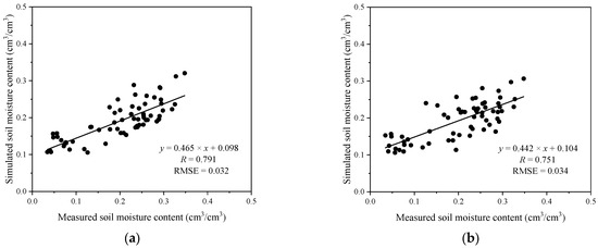
Figure 8.
Scatter plot between the measured and simulated soil moisture at X- (a) and C-bands (b) extracted from soil moisture maps in Figure 7 (The units of RMSE is cm3/cm3).
In order to evaluate the spatial distribution of soil moisture at X- and C-bands in the same resolution, the soil moisture maps from KOMPSAT-5 SAR data were resampled to 10 m, coinciding with that from Sentinel-1 data, over the three field sites. Meanwhile, the values of soil moisture with over 0.5 cm3/cm3 were eliminated so as to ensure the validity of soil moisture remote sensing monitoring. Figure 9 shows the pyramid plot of retrieved soil moisture at X- and C-bands with the same resolution of 10 m over the three field sites. The values of soil moisture were divided in 10 groups from 0 to 0.5 cm3/cm3 with the interval of 0.05 cm3/cm3. As can be seen from Figure 9, most of the soil moisture values are relatively compact and distributed between 0.20 and 0.25 cm3/cm3 at both X- and C-bands in Site a#, while the soil moisture is between 0.10 and 0.20 cm3/cm3 in Site c#. For Site b#, the soil moisture values at C-band are higher than that at X-band. The percentage of soil moisture values are distributed between 0.15 and 0.25 cm3/cm3. Overall, both X-band KOMPSAT-5 and C-band Sentinel-1 SAR data could be applicable for soil moisture retrieval based on the proposed model in vegetated regions.
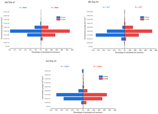
Figure 9.
Pyramid plot of estimated soil moisture at X- and C-bands over the three field sites.
5. Discussion
This paper evaluates the performance of X- and C-band SAR data on soil moisture retrieval using a semi-empirical scattering model. Compared with Bao’s model, the semi-empirical model establishes the soil moisture estimated mechanisms and depicts the soil moisture status and vegetation precisely. As shown in Figure 6, the semi-empirical model shows a more favorable correlation with measured soil moisture than Bao’s model. However, there are several factors affecting the inversion results, for example, speckle noises of remote sensing data, restrictions of field observations, and uncertainties of scattering methods.
In Figure 6, the results showed a similar estimation accuracy using the proposed model at both X- and C-bands. The R and RMSE are not very satisfying. Several reasons need to be clarified and discussed here. First, for the models used in this paper, the vegetation canopy might be the most important input parameter in vegetation-covered soil moisture retrieval. Thus, the uncertainties of the models mainly depend on this variable. For the influence of vegetation canopy from the radar signal, biophysical parameters (e.g., NDVI, NDWI, LAI or crown water content) are used to calculate the vegetation effects on radar signature [68,69,70,71,72,73]. Then, the SAR configurations would be responsible for these unsatisfying results. As we know, the L-band microwave sensor was considered as the optimal choice in the potential applications for the incorporation of soil moisture estimates [74]. However, the operational L-band satellite radiometers have the limitation of moderately coarse spatial resolution. Though C-band SAR data have very high spatial resolution, they are more sensitive to vegetation canopy than L-band data in vegetated regions. The X-band SAR can describe the accurate characteristics of the soil surface more accurately than the C- and L-bands when observing at the same incidence angle. Thus, the X-band sensor is susceptible to vegetation cover and is typically sensitive to low-biomass land cover. The effectiveness and availability of L-, C- and X-bands SAR data in soil moisture retrieval should be evaluated in the future work. Furthermore, addressing the generalization of the empirical model is an important issue for soil moisture products. In the study, ground measurements and three representative field sites were used to evaluate the effectiveness and feasibility of the model. They reveal that our model can be suitable for any vegetation-covered regions. Meanwhile, constructing simple and effective scattering models will play an important role in soil moisture monitoring and product development. Therefore, further study on the empirical model is both necessary and significant. In addition, surface roughness is also regarded as one of the most important variables in soil moisture retrieval. Surface roughness parameters, especially correlation length, fail to depict the actual shape of soil surface and are not constant according to the applicable conditions [75,76]. Thus, several combined roughness parameters were proposed to improve the estimated accuracy of surface roughness and reduce the uncertainties of structural coefficients [56,63,77]. More work is needed to obtain the optimal vegetation and soil parameters in vegetation-covered soil moisture estimates.
As shown in Figure 7, the soil moisture maps at X- and C-bands are slightly different. Soil moisture varying from 0.05 to 0.30 cm3/cm3 indicates a slightly dry soil condition due to reduced rainfall in September. Actually, for Site c#, the X- and C-bands SAR overestimated the soil moisture in the middle of the southern parts, which can be explained because no measurements were conducted in this area to calibrate the proposed model. A small natural land with shrubs and riparian trees lies in the middle of southern region. A stream runs towards the northeast and remains dry for the whole year. In the southwestern region, the highest sand cover (70–75%) makes this region very dry. However, the maps at X- and C-bands in Figure 7e,f show relatively high values of soil moisture content in that region. This can be explained from two aspects: first, only small sampling points are distributed there, and the model cannot get sufficient information for the training; second, the proportional value of the sand used in the semi-empirical model is much lower than that in this region. In addition, soil texture, vegetation type and other ancillary information should be considered, and more investigation needs to follow to regionalize the model coefficients and improve the estimated accuracy of soil moisture in the future.
6. Conclusions
In this paper, KOMPSAT-5 and Sentinel-1 radar data were compared to explore the effectiveness and potential in soil moisture estimation over vegetated areas. A new semi-empirical scattering model was used based on a vegetation scattering model and a vegetation water content mode. CVI is introduced to parameterize the vegetation water content and remove the effects of vegetation on radar signals in the proposed model. Results showed that this study effectively revealed the mechanism of radar signal and vegetation on soil moisture retrieval and established the exact nonlinear relationship between backscatter coefficient and soil moisture. The semi-empirical model presented the expression of soil moisture retrieval and solved it mathematically to obtain continuous spatial distribution of soil moisture. Meanwhile, compared with change detection and machine learning approaches, a small number of simulated datasets was enough to realize the inversion process of soil moisture and improve the inversion accuracy in this study. As illustrated above, soil moisture was obtained with R of 0.862 and 0.616 using KOMPSAT-5 and Sentinel-1 radar data. The RMSEs were 0.020 cm3/cm3 and 0.032 cm3/cm3 at X- and C-bands. The CVI and VV polarization combination method has a better soil moisture retrieval accuracy than NDVI and NDWI. Soil moisture mapping was generated based on SAR images and the results demonstrated that similar results were found between the estimated soil moisture using X-band SAR data and the in situ measurements. X-band SAR data are suitable for the soil moisture retrieval in agricultural areas. Meanwhile, considering the simplicity and practicality of the proposed model, it can be used to operationalize soil moisture retrieval and produce real-time soil moisture products.
However, temporal gaps between the acquisition times of SAR and optical data may have introduced some errors in soil moisture retrieval. Errors from data preprocessing and field measurements can also seriously affect the accuracy of soil moisture retrieval. In addition, the semi-empirical model needs to be calibrated according to the soil type and vegetation growth status. Thus, in future work, more observations and ground measurements will be acquired to provide higher temporal resolution monitoring and validate the potential of X-band SAR data in soil moisture estimation. Meanwhile, soil type and vegetation growth status will be considered in field experiment to make the model more robust and applicable in other agricultural areas.
Author Contributions
Conceptualization, L.T. and D.R.; methodology, L.T.; software, L.T.; validation, L.T. and S.-G.L.; data curation, S.-G.L.; writing—original draft preparation, L.T.; writing—review and editing, D.R. and A.W.; funding acquisition, L.T. and D.R. All authors have read and agreed to the published version of the manuscript.
Funding
This research was funded by National Natural Science Foundation of China (41901278), by Science and Technology Project of Jiangsu Province (BK20180798), and by the University of Melbourne Research Contract #300405 sponsored by the Korea Aerospace Research Institute.
Data Availability Statement
Not applicable.
Acknowledgments
The authors would like to thank every member who contributed to the manuscript.
Conflicts of Interest
The authors declare no conflict of interest.
References
- Fan, L.; Al-Yaari, A.; Frappart, F.; Peng, J.; Wen, J.; Xiao, Q.; Jin, R.; Li, X.; Liu, X.; Wang, M. Estimating High-Resolution Soil Moisture Over Mountainous Regions Using Remotely-Sensed Multispectral and Topographic Data. IEEE J. Sel. Top. Appl. Earth Obs. Remote Sens. 2022, 15, 3637–3649. [Google Scholar] [CrossRef]
- Srivastava, A.; Saco, P.M.; Rodriguez, J.F.; Kumari, N.; Chun, K.P.; Yetemen, O. The role of landscape morphology on soil moisture variability in semi-arid ecosystems. Hydrol. Process. 2021, 35, e13990. [Google Scholar] [CrossRef]
- Ivanov, V.Y.; Fatichi, S.; Jenerette, G.D.; Espeleta, J.F.; Troch, P.A.; Huxman, T.E. Hysteresis of soil moisture spatial heterogeneity and the “homogenizing” effect of vegetation. Water Resour. Res. 2010, 46. [Google Scholar] [CrossRef]
- Fatichi, S.; Katul, G.G.; Ivanov, V.Y.; Pappas, C.; Paschalis, A.; Consolo, A.; Kim, J.; Burlando, P. Abiotic and biotic controls of soil moisture spatiotemporal variability and the occurrence of hysteresis. Water Resour. Res. 2015, 51, 3505–3524. [Google Scholar] [CrossRef]
- Panciera, R.; Tanase, M.A.; Lowell, K.; Walker, J.P. Evaluation of IEM, Dubois, and Oh Radar Backscatter Models Using Airborne L-Band SAR. IEEE Tract. Geosci. Remote Sens. 2014, 52, 4966–4979. [Google Scholar] [CrossRef]
- Merzouki, A.; McNairn, H.; Pacheco, A. Evaluation of the Dubois, Oh, and IEM radar backscatter models over agricultural fields using C-band RADARSAT-2 SAR image data. Can. J. Remote Sens. 2014, 36, S274–S286. [Google Scholar] [CrossRef]
- Baghdadi, N.; Zribi, M. Evaluation of radar backscatter models IEM, OH and Dubois using experimental observations. Int. J. Remote Sens. 2007, 27, 3831–3852. [Google Scholar] [CrossRef]
- Shahrezaei, I.H.; Kim, H.-C. Fractal Analysis and Texture Classification of High-Frequency Multiplicative Noise in SAR Sea-Ice Images Based on a Transform- Domain Image Decomposition Method. IEEE Access 2020, 8, 40198–40223. [Google Scholar] [CrossRef]
- Han, H.; Kim, H.-C. Evaluation of summer passive microwave sea ice concentrations in the Chukchi Sea based on KOMPSAT-5 SAR and numerical weather prediction data. Remote Sens. Environ. 2018, 209, 343–362. [Google Scholar] [CrossRef]
- Han, H.; Hong, S.-H.; Kim, H.-C.; Chae, T.-B.; Choi, H.-J. A study of the feasibility of using KOMPSAT-5 SAR data to map sea ice in the Chukchi Sea in late summer. Remote Sens. Lett. 2017, 8, 468–477. [Google Scholar] [CrossRef]
- Hwang, J.-I.; Jung, H.-S. Automatic Ship Detection Using the Artificial Neural Network and Support Vector Machine from X-Band Sar Satellite Images. Remote Sens. 2018, 10, 1799. [Google Scholar] [CrossRef]
- Hwang, J.-I.; Chae, S.-H.; Kim, D.; Jung, H.-S. Application of Artificial Neural Networks to Ship Detection from X-Band Kompsat-5 Imagery. Appl. Sci. 2017, 7, 961. [Google Scholar] [CrossRef]
- Back, M.; Kim, D.; Kim, S.-W.; Won, J.-S. Two-Dimensional Ship Velocity Estimation Based on KOMPSAT-5 Synthetic Aperture Radar Data. Remote Sens. 2019, 11, 1474. [Google Scholar] [CrossRef]
- Park, W.; Baek, W.-K.; Won, J.-S.; Jung, H.-S. Comparison of Input Image Dimensions for Ship Detection from KOMPSAT-5 SAR Image Using Deep Neural Network. J. Coastal Res. 2020, 102, 208–217. [Google Scholar] [CrossRef]
- Lee, Y.-S.; Park, S.-H.; Jung, H.-S.; Baek, W.-K. Classification of natural and artificial forests from KOMPSAT-3/3A/5 images using artificial neural network. Korean J. Remote Sens. 2018, 34, 1399–1414. [Google Scholar]
- Park, S.-E.; Lee, S.-G. Change Detection of Urban Areas Affected by Earthquake Using Kompsat-5 Data. In Proceedings of the IGARSS—2020 IEEE International Geoscience and Remote Sensing Symposium, Waikoloa, HI, USA, 26 September–2 October 2020; IEEE: Piscataway, NJ, USA, 2020; pp. 3568–3570. [Google Scholar]
- Park, S.-E. Detection of water bodies from Kompsat-5 SAR data. Korean J. Remote Sens. 2016, 32, 539–550. [Google Scholar] [CrossRef]
- Refice, A.; Zingaro, M.; D’Addabbo, A.; Chini, M. Integrating C- and L-Band SAR Imagery for Detailed Flood Monitoring of Remote Vegetated Areas. Water 2020, 12, 2745. [Google Scholar] [CrossRef]
- Anzidei, M.; Scicchitano, G.; Scardino, G.; Bignami, C.; Tolomei, C.; Vecchio, A.; Serpelloni, E.; De Santis, V.; Monaco, C.; Milella, M.; et al. Relative Sea-Level Rise Scenario for 2100 along the Coast of South Eastern Sicily (Italy) by InSAR Data, Satellite Images and High-Resolution Topography. Remote Sens. 2021, 13, 1108. [Google Scholar] [CrossRef]
- Kim, D.-J.; Moon, W.M.; Hwang, J.-H.; Kim, Y.-S. Application of KOMPSAT-5 Data for Emergent Oil Spill Monitoring. In Proceedings of the 2010 IEEE International Geoscience and Remote Sensing Symposium, Honolulu, HI, USA, 25–30 July 2010; IEEE: Piscataway, NJ, USA, 2010; pp. 1254–1257. [Google Scholar]
- Kim, D.-J. Monitoring of coastal wind and oil spill using KOMPSAT-5. In Proceedings of the 2011 3rd International Asia-Pacific Conference on Synthetic Aperture Radar (APSAR), Seoul, Korea, 26–30 September 2011; IEEE: Piscataway, NJ, USA, 2011; pp. 1–4. [Google Scholar]
- Harahsheh, H. Oil spill detection and monitoring of Abu Dhabi coastal zone using KOMPSAT-5 SAR imagery. Int. Arch. Photogramm. Remote Sens. Spat. Inf. Sci. 2016, 41, 1115–1121. [Google Scholar] [CrossRef]
- Shi, J.; Wang, J.; Hsu, A.Y.; O’Neill, P.E.; Engman, E.T. Estimation of bare surface soil moisture and surface roughness parameter using L-band SAR image data. IEEE Tract. Geosci. Remote Sens. 1997, 35, 1254–1266. [Google Scholar]
- Oh, Y.; Sarabandi, K.; Ulaby, F.T. Semi-empirical model of the ensemble-averaged differential Mueller matrix for microwave backscattering from bare soil surfaces. IEEE Tract. Geosci. Remote Sens. 2002, 40, 1348–1355. [Google Scholar] [CrossRef]
- Fung, A.K.; Li, Z.; Chen, K.-S. Backscattering from a randomly rough dielectric surface. IEEE Tract. Geosci. Remote Sens. 1992, 30, 356–369. [Google Scholar] [CrossRef]
- Dubois, P.C.; Van Zyl, J.; Engman, T. Measuring soil moisture with imaging radars. IEEE Tract. Geosci. Remote Sens. 1995, 33, 915–926. [Google Scholar] [CrossRef]
- Chen, K.S.; Tzong-Dar, W.; Leung, T.; Qin, L.; Jiancheng, S.; Fung, A.K. Emission of rough surfaces calculated by the integral equation method with comparison to three-dimensional moment method simulations. IEEE Tract. Geosci. Remote Sens. 2003, 41, 90–101. [Google Scholar] [CrossRef]
- Ulaby, F.T.; Sarabandi, K.; Mcdonald, K.; Whitt, M.; Dobson, M.C. Michigan microwave canopy scattering model. Int. J. Remote Sens. 1990, 11, 1223–1253. [Google Scholar] [CrossRef]
- Graham, A.; Harris, R. Extracting biophysical parameters from remotely sensed radar data: A review of the water cloud model. Prog. Phys. Geog. 2003, 27, 217–229. [Google Scholar] [CrossRef]
- De Roo, R.D.; Du, Y.; Ulaby, F.T.; Dobson, M.C. A semi-empirical backscattering model at L-band and C-band for a soybean canopy with soil moisture inversion. IEEE Tract. Geosci. Remote Sens. 2001, 39, 864–872. [Google Scholar] [CrossRef]
- Attema, E.P.W.; Ulaby, F.T. Vegetation modeled as a water cloud. Radio Sci. 1978, 13, 357–364. [Google Scholar] [CrossRef]
- Liu, C.; Shi, J. Estimation of Vegetation Parameters of Water Cloud Model for Global Soil Moisture Retrieval Using Time-Series L-Band Aquarius Observations. IEEE J. Sel. Top. Appl. Earth Obs. Remote Sens. 2016, 9, 5621–5633. [Google Scholar] [CrossRef]
- Li, J.; Wang, S. Using SAR-Derived Vegetation Descriptors in a Water Cloud Model to Improve Soil Moisture Retrieval. Remote Sens. 2018, 10, 1370. [Google Scholar] [CrossRef]
- Wang, Z.; Zhao, T.; Qiu, J.; Zhao, X.; Li, R.; Wang, S. Microwave-based vegetation descriptors in the parameterization of water cloud model at L-band for soil moisture retrieval over croplands. GISci. Remote Sens. 2021, 58, 48–67. [Google Scholar] [CrossRef]
- Dabrowska-Zielinska, K.; Musial, J.; Malinska, A.; Budzynska, M.; Gurdak, R.; Kiryla, W.; Bartold, M.; Grzybowski, P. Soil Moisture in the Biebrza Wetlands Retrieved from Sentinel-1 Imagery. Remote Sens. 2018, 10, 1979. [Google Scholar] [CrossRef]
- Rawat, K.S.; Singh, S.K.; Ray, R.L.; Szabó, S.; Kumar, S. Parameterizing the modified water cloud model to improve soil moisture data retrieval using vegetation models. Hungarian Geograph. Bull. 2020, 69, 17–26. [Google Scholar] [CrossRef]
- Tao, L.; Wang, G.; Chen, W.; Chen, X.; Li, J.; Cai, Q. Soil Moisture Retrieval From SAR and Optical Data Using a Combined Model. IEEE J. Sel. Top. Appl. Earth Obs. Remote Sens. 2019, 12, 637–647. [Google Scholar] [CrossRef]
- Wagner, W.; Lemoine, G.; Borgeaud, M.; Rott, H. A study of vegetation cover effects on ERS scatterometer data. IEEE Tract. Geosci. Remote Sens. 1999, 37, 938–948. [Google Scholar] [CrossRef]
- Santi, E.; Paloscia, S.; Pettinato, S.; Fontanelli, G. Application of artificial neural networks for the soil moisture retrieval from active and passive microwave spaceborne sensors. Int. J. Appl. Earth Obs. Geoinf. 2016, 48, 61–73. [Google Scholar] [CrossRef]
- Hornacek, M.; Wagner, W.; Sabel, D.; Truong, H.-L.; Snoeij, P.; Hahmann, T.; Diedrich, E.; Doubkova, M. Potential for High Resolution Systematic Global Surface Soil Moisture Retrieval via Change Detection Using Sentinel-1. IEEE J. Sel. Top. Appl. Earth Obs. Remote Sens. 2012, 5, 1303–1311. [Google Scholar] [CrossRef]
- Hachani, A.; Ouessar, M.; Paloscia, S.; Santi, E.; Pettinato, S. Soil moisture retrieval from Sentinel-1 acquisitions in an arid environment in Tunisia: Application of Artificial Neural Networks techniques. Int. J. Remote Sens. 2019, 40, 9159–9180. [Google Scholar] [CrossRef]
- Xue, Z.; Zhang, Y.; Zhang, L.; Li, H. Ensemble Learning Embedded with Gaussian Process Regression for Soil Moisture Estimation: A Case Study of the Continental US. IEEE Tract. Geosci. Remote Sens. 2022, 60, 1–17. [Google Scholar] [CrossRef]
- Elshorbagy, A.; Parasuraman, K. On the relevance of using artificial neural networks for estimating soil moisture content. J. Hydrol. 2008, 362, 1–18. [Google Scholar] [CrossRef]
- Nagler, T.; Rott, H.; Hetzenecker, M.; Wuite, J.; Potin, P. The Sentinel-1 mission: New opportunities for ice sheet observations. Remote Sens. 2015, 7, 9371–9389. [Google Scholar] [CrossRef]
- Abdikan, S.; Sanli, F.B.; Ustuner, M.; Calò, F. Land cover mapping using sentinel-1 SAR data. Int. Arch. Photogramm. Remote Sens. Spat. Inf. Sci. 2016, 41, 757. [Google Scholar] [CrossRef]
- Mandal, D.; Kumar, V.; Ratha, D.; Dey, S.; Bhattacharya, A.; Lopez-Sanchez, J.M.; McNairn, H.; Rao, Y.S. Dual polarimetric radar vegetation index for crop growth monitoring using sentinel-1 SAR data. Remote Sens. Environ. 2020, 247, 111954. [Google Scholar] [CrossRef]
- Khabbazan, S.; Vermunt, P.; Steele-Dunne, S.; Arntz Lexy, R.; Marinetti, C.; van der Valk, D.; Iannini, L.; Molijn, R.; Westerdijk, K.; van der Sande, C. Crop Monitoring Using Sentinel-1 Data: A Case Study from The Netherlands. Remote Sens. 2019, 11, 1997. [Google Scholar] [CrossRef]
- Wang, Y.; Wang, C.; Zhang, H. Combining a single shot multibox detector with transfer learning for ship detection using sentinel-1 SAR images. Remote Sens. Lett. 2018, 9, 780–788. [Google Scholar] [CrossRef]
- Funning, G.J.; Garcia, A. A systematic study of earthquake detectability using Sentinel-1 Interferometric Wide-Swath data. Geophys. J. Int. 2019, 216, 332–349. [Google Scholar] [CrossRef]
- Boni, G.; Ferraris, L.; Pulvirenti, L.; Squicciarino, G.; Pierdicca, N.; Candela, L.; Pisani, A.R.; Zoffoli, S.; Onori, R.; Proietti, C. A prototype system for flood monitoring based on flood forecast combined with COSMO-SkyMed and Sentinel-1 data. IEEE J. Sel. Top. Appl. Earth Obs. Remote Sens. 2016, 9, 2794–2805. [Google Scholar] [CrossRef]
- Nguyen, H.H.; Cho, S.; Jeong, J.; Choi, M. A D-vine copula quantile regression approach for soil moisture retrieval from dual polarimetric SAR Sentinel-1 over vegetated terrains. Remote Sens. Environ. 2021, 255, 112283. [Google Scholar] [CrossRef]
- Fan, D.; Zhao, T.; Jiang, X.; Xue, H.; Moukomla, S.; Kuntiyawichai, K.; Shi, J. Soil Moisture Retrieval From Sentinel-1 Time-Series Data Over Croplands of Northeastern Thailand. IEEE Geosci. Remote Sens. Lett. 2021, 19, 1–5. [Google Scholar] [CrossRef]
- Zakharov, I.; Kapfer, M.; Hornung, J.; Kohlsmith, S.; Puestow, T.; Howell, M.; Henschel, M.D. Retrieval of Surface Soil Moisture From Sentinel-1 Time Series for Reclamation of Wetland Sites. IEEE J. Sel. Top. Appl. Earth Obs. Remote Sens. 2020, 13, 3569–3578. [Google Scholar] [CrossRef]
- Chatterjee, S.; Huang, J.; Hartemink, A.E. Establishing an Empirical Model for Surface Soil Moisture Retrieval at the US Climate Reference Network Using Sentinel-1 Backscatter and Ancillary Data. Remote Sens. 2020, 12, 1242. [Google Scholar] [CrossRef]
- Saatchi, S.S.; Moghaddam, M. Estimation of crown and stem water content and biomass of boreal forest using polarimetric SAR imagery. IEEE Tract. Geosci. Remote Sens. 2000, 38, 697–709. [Google Scholar] [CrossRef]
- Tao, L.; Li, J.; Chen, X.; Cai, Q.; Zhang, Y. An Effective Model to Retrieve Soil Moisture from L- and C-Band SAR Data. J. Indian Soc. Remote Sens. 2017, 45, 621–629. [Google Scholar] [CrossRef]
- Prakash Mohan, M.M.; Rajitha, K.; Varma Murari, R.R. Integration of soil moisture as an auxiliary parameter for the anchor pixel selection process in SEBAL using Landsat 8 and Sentinel-1A images. Int. J. Remote Sens. 2020, 41, 1214–1231. [Google Scholar] [CrossRef]
- Fan, L.; Wigneron, J.-P.; Xiao, Q.; Al-Yaari, A.; Wen, J.; Martin-StPaul, N.; Dupuy, J.-L.; Pimont, F.; Al Bitar, A.; Fernandez-Moran, R. Evaluation of microwave remote sensing for monitoring live fuel moisture content in the Mediterranean region. Remote Sens. Environ. 2018, 205, 210–223. [Google Scholar] [CrossRef]
- Rouse, J.; Haas, R.; Schell, J.; Deering, D. Monitoring vegetation systems in the Great Plains with ERTS: Proceedings of the Third Earth Resources Technology Satellite-1 Symposium. In NASA SP-351; Scientific and Technical Information Office, National Aeronautics and Space Administration: Washington, DC, USA, 1974; pp. 301–317. [Google Scholar]
- Gao, B.-C. NDWI—A normalized difference water index for remote sensing of vegetation liquid water from space. Remote Sens. Environ. 1996, 58, 257–266. [Google Scholar] [CrossRef]
- Moreau, S.; Bosseno, R.; Gu, X.F.; Baret, F. Assessing the biomass dynamics of Andean bofedal and totora high-protein wetland grasses from NOAA/AVHRR. Remote Sens. Environ. 2003, 85, 516–529. [Google Scholar] [CrossRef]
- Sibanda, M.; Mutanga, O.; Rouget, M. Examining the potential of Sentinel-2 MSI spectral resolution in quantifying above ground biomass across different fertilizer treatments. Isprs J. Photogramm. Remote Sens. 2015, 110, 55–65. [Google Scholar] [CrossRef]
- Zribi, M.; Dechambre, M. A new empirical model to retrieve soil moisture and roughness from C-band radar data. Remote Sens. Environ. 2003, 84, 42–52. [Google Scholar] [CrossRef]
- Mattia, F.; Satalino, G.; Dente, L.; Pasquariello, G. Using a priori information to improve soil moisture retrieval from ENVISAT ASAR AP data in semiarid regions. IEEE Tract. Geosci. Remote Sens. 2006, 44, 900–912. [Google Scholar] [CrossRef]
- Jackson, T.J.; Chen, D.; Cosh, M.; Li, F.; Anderson, M.; Walthall, C.; Doriaswamy, P.; Hunt, E.R. Vegetation water content mapping using Landsat data derived normalized difference water index for corn and soybeans. Remote Sens. Environ. 2004, 92, 475–482. [Google Scholar] [CrossRef]
- Bao, Y.; Lin, L.; Wu, S.; Kwal Deng, K.A.; Petropoulos, G.P. Surface soil moisture retrievals over partially vegetated areas from the synergy of Sentinel-1 and Landsat 8 data using a modified water-cloud model. Int. J. Appl. Earth Obs. Geoinf. 2018, 72, 76–85. [Google Scholar] [CrossRef]
- Tao, L.; Ryu, D.; Western, A.; Lee, S.-G. Intercomparison of X-and C-Bands Active Microwave Soil Moisture Retrievals Over Dryland Wheat Fields. In Proceedings of the IGARSS 2020-2020 IEEE International Geoscience and Remote Sensing Symposium, Waikoloa, HI, USA, 26 September–2 October 2020; IEEE: Piscataway, NJ, USA, 2020; pp. 3560–3563. [Google Scholar]
- Wang, S.G.; Li, X.; Han, X.J.; Jin, R. Estimation of surface soil moisture and roughness from multi-angular ASAR imagery in the Watershed Allied Telemetry Experimental Research (WATER). Hydrol. Earth Syst. Sci. 2011, 15, 1415–1426. [Google Scholar] [CrossRef]
- Prakash, R.; Singh, D.; Pathak, N.P. A Fusion Approach to Retrieve Soil Moisture With SAR and Optical Data. IEEE J. Sel. Top. Appl. Earth Obs. Remote Sens. 2012, 5, 196–206. [Google Scholar] [CrossRef]
- Lievens, H.; Verhoest, N.E.C. On the Retrieval of Soil Moisture in Wheat Fields From L-Band SAR Based on Water Cloud Modeling, the IEM, and Effective Roughness Parameters. IEEE Geosci. Remote Sens. Lett. 2011, 8, 740–744. [Google Scholar] [CrossRef]
- Bindlish, R.; Barros, A.P. Parameterization of vegetation backscatter in radar-based, soil moisture estimation. Remote Sens. Environ. 2001, 76, 130–137. [Google Scholar] [CrossRef]
- Bai, X.; He, B.; Xing, M.; Li, X. Method for soil moisture retrieval in arid prairie using TerraSAR-X data. J. Appl. Remote Sens. 2015, 9, 096062. [Google Scholar] [CrossRef]
- Baghdadi, N.; El Hajj, M.; Zribi, M.; Bousbih, S. Calibration of the Water Cloud Model at C-Band for Winter Crop Fields and Grasslands. Remote Sens. 2017, 9, 969. [Google Scholar] [CrossRef]
- Shi, J.; Chen, K.-S.; Li, Q.; Jackson, T.J.; O’Neill, P.E.; Tsang, L. A parameterized surface reflectivity model and estimation of bare-surface soil moisture with L-band radiometer. IEEE Tract. Geosci. Remote Sens. 2002, 40, 2674–2686. [Google Scholar]
- Wagner, W.; Bloeschl, G.; Pampaloni, P.; Calvet, J.-C.; Bizzarri, B.; Wigneron, J.-P.; Kerr, Y. Operational readiness of microwave remote sensing of soil moisture for hydrologic applications. Nord. Hydrol. 2007, 38, 1–20. [Google Scholar] [CrossRef]
- Callens, M.; Verhoest, N.E.; Davidson, M.W. Parameterization of tillage-induced single-scale soil roughness from 4-m profiles. IEEE Tract. Geosci. Remote Sens. 2006, 44, 878–888. [Google Scholar] [CrossRef]
- Su, Z.; Troch, P.A.; De Troch, F. Remote sensing of bare surface soil moisture using EMAC/ESAR data. Int. J. Remote Sens. 1997, 18, 2105–2124. [Google Scholar] [CrossRef]
Publisher’s Note: MDPI stays neutral with regard to jurisdictional claims in published maps and institutional affiliations. |
© 2022 by the authors. Licensee MDPI, Basel, Switzerland. This article is an open access article distributed under the terms and conditions of the Creative Commons Attribution (CC BY) license (https://creativecommons.org/licenses/by/4.0/).