Article

Flash Flood Risk Assessment and Mitigation in Digital-Era Governance Using Unmanned Aerial Vehicle and GIS Spatial Analyses Case Study: Small River Basins

by
Ștefan Bilașco
1,2,*,
Gheorghe-Gavrilă Hognogi
1,3,
Sanda Roșca
1,
Ana-Maria Pop
3,
Vescan Iuliu
1,
Ioan Fodorean
1,
Alexandra-Camelia Marian-Potra
4 and
Paul Sestras
5
1
Faculty of Geography, Babeș-Bolyai University, 400006 Cluj-Napoca, Romania
2
Cluj-Napoca Subsidiary Geography Section, Romanian Academy, 400015 Cluj-Napoca, Romania
3
Centre for Regional Geography, Faculty of Geography, Babeș-Bolyai University, 400006 Cluj-Napoca, Romania
4
Department of Geography, Faculty of Biology, Chemistry and Geography, West University of Timişoara, 300223 Timișoara, Romania
5
Faculty of Civil Engineering, Technical University of Cluj-Napoca, 400020 Cluj-Napoca, Romania
*
Author to whom correspondence should be addressed.
Remote Sens. 2022, 14(10), 2481; https://doi.org/10.3390/rs14102481
Submission received: 2 May 2022 / Revised: 11 May 2022 / Accepted: 19 May 2022 / Published: 22 May 2022
(This article belongs to the Topic Natural Hazards and Disaster Risks Reduction)

Abstract

:
Watercourses act like a magnet for human communities and were always a deciding factor when choosing settlements. The reverse of these services is a potential hazard in the form of flash flooding, for which human society has various management strategies. These strategies prove to be increasingly necessary in the context of increased anthropic pressure on the floodable areas. One of these strategies, Strategic Flood Management (SFM), a continuous cycle of planning, acting, monitoring, reviewing and adapting, seems to have better chances to succeed than other previous strategies, in the context of the Digital-Era Governance (DEG). These derive, among others, from the technological and methodological advantages of DEG. Geographic Information Systems (GIS) and Unmanned Aerial Vehicles (UAV) stand out among the most revolutionary tools for data acquisition and processing of data in the last decade, both in qualitative and quantitative terms. In this context, this study presents a hybrid risk assessment methodology for buildings in case of floods. The methodology is based on detailed information on the terrestrial surface—digital surface model (DSM) and measurements of the last historical flash flood level (occurred on 20 June 2012)—that enabled post-flood peak discharge estimation. Based on this methodology, two other parameters were calculated together with water height (depth): shear stress and velocity. These calculations enabled the modelling of the hazard and risk map, taking into account the objective value of buildings. The two components were integrated in a portal available for the authorities and inhabitants. Both the methodology and the portal are perfectible, but the value of this material consists of the detailing and replicability potential of the data that can be made available to administration and local community. Conceptually, the following are relevant (a) the framing of the SFM concept in the DEG framework and (b) the possibility to highlight the involvement and contribution of the citizens in mapping the risks and their adaptation to climate changes. The subsequent version of the portal is thus improved by further contributions and the participatory approach of the citizens.

1. Introduction

The prognosis and spatial identification of the areas prone to flash flood risk represent the current challenges that local public authorities are facing. Solutions should be looked for in the general context of current climate changes. One of the specific elements of climate change is represented by the high amount of rainfall over a short time interval, with a rapid response in terms of hydrodynamics and processes related to negative effects on human communities [1,2,3,4]. Each year, millions of people from all over the world are forced to relocate their residence due to the indirect effects of climate change. Floods are responsible for the largest part of these relocations [5].
The attention that decision-makers worldwide are paying to floods and other natural risk phenomena is proven among others by: (a) the United Nation’s Agenda Transforming our world: the 2030 Agenda for Sustainable Development, with its Goal 13—“Take urgent action to combat climate change and its impacts”; (b) UNESCO’s synthesis on Flood Risk Management: a Strategic Approach, a part of the Strategic Water Management in the 21st Century series [6]; (c) the Disaster Resilience: A National Imperative, 2012 Report, focusing on the need to create a resilience culture among communities in the USA; (d) the European Directive 2007/60/EC on the assessment and management of flood risks suggesting that the member states should assess the activities that generate the increase in flood risks based on local and regional circumstances. Moreover, they should base their assessments, maps and plans on the appropriate best practices and best available technologies, not entailing excessive costs for flood risk management [7,8,9].
Recently, the digitalization of the flood effects management gained higher importance in terms of the response, recovery and attenuation of their effects. The role of technology in managing the direct and indirect effects of floods is to connect, inform and eventually save the lives of those affected. In this regard, it is useful to create a cooperation system with crowdsourced, spatial and historical data with scalability potential [10]. This system could be integrated in an application that, in case of a weather warning, should inform the user on the location of a floodable area [11]. The development of tools for behavior modeling and simulation, as well as of the drainage network characteristics, is possible on the GIS platform, where heterogeneous data sources can be integrated [12,13], including those achieved by means of UAV [14,15]. This leads to the opportunity for the real-time simulation of some flood-type events, especially with the purpose of improving the warning procedures and enabling the local stakeholders to periodically update their risk maps [16]. These new opportunities need to be correlated with awareness campaigns, including by encouraging the creation of some insurance policies [17] in order to reduce the financial pressure on central and/or local authorities.
Communities’ relations to the implications of floods should be managed by a Strategic Flood Management (SFM). A really efficient SFM may be more easily imagined in Digital-Era Governance (DGE)—a macro-theory of public sector development and the continuation of New Public Management, whose final stage is defined by the promotion of a ’Social Web’ [18]. Right from the appearance of the idea, it was assumed that DEG will imply the reintegration of functions in the governmental sphere, adoption of needs-oriented structures and the progress in the digitalization of administrative processes [19]. Here, we refer to the electronic dialog between the public administrations, citizens and companies, which represents the key element for the development of the public sector [20]. This interactive communication, capable of information and knowledge exchange, is both a tool for action and a main responsibility of the municipalities in the digital era.
In this case, the implementation of UAV techniques and GIS spatial analysis [21] makes it easier to acquire digital databases that can be used in spatial analysis models to identify vulnerability and risk of flooding and to improve the accuracy of the final result. At the same time, the spatial database resource is made available to the local public administration for the purpose of integration in the local IT system and information to be as complete as possible [22].
In the last decade, it was assessed that UAVs, with their capacities, were able to revolutionize natural resource management, remote sensing and many other fields, in the same way the emergence of GIS did three decades ago [23]. The frequency of using UAVs in the study of extreme natural phenomena is highlighted by a series of specialized studies, which treat the implications of this technology for the management and monitoring of natural hazards [24,25]. In addition, the frequent use of UAV is supported by the fact that it can operate like a Big Data system in natural disaster management [26,27] or as a source of images, which can be processed by means of remote sensing and GIS techniques, with good results in water resources and flood risk management [3].
Having multiple uses for wetland mapping and hydrological modeling [28,29], UAVs stand out among the applications dedicated to the study of floods due to the times in which they can be used, i.e., before (prevention), during and after occurrence (e.g., damage assessment, remapping of the affected area). UAV applications support the planning and preparedness of flood emergency responses and the development of tools that enable the response before, during and after the event [30].
One of the topics intensely addressed in hydrology is represented by the effect of the digital elevation model (DEM) resolution on floodable stripes modeling [31]. At large scale, this issue is solved. The DEM resulting from images processed through the SFM method is a relatively rapid and detailed enough product that enables the monitoring of channel morphology variation [32,33,34,35].
UAV is frequently used for acquiring a high accuracy DEM or digital surface model (DSM), which can become an input database for the hydraulic models for tracing the floodable stripes [36,37,38]. UAVs may be supports for the calibration and validation of the hydraulic models conducted at small topographic scales [39,40,41,42,43]. In this case, their role is indisputable, considering the importance of precision in mapping the floodable stripes. The digital elevation models obtained based on the UAV technique were integrated as input databases in various types of GIS models. The models implemented based on the dedicated software, HEC-RAS, were used for the achievement of the floodable stripes [44,45,46,47,48,49,50] or for flood vulnerability identification [51,52,53]. Many expert studies underline the usefulness of DEM and DSM, achieved by means of a UAV with an RGB sensor, in order to conduct the levels of hydraulic modeling for various sectors of the hydrographic networks of various riverbed geometries [32,36,37,54].
It is difficult to imagine now the full coverage of an extended area with detailed data and often very expensive sensors, although the evolution of the technology leads to an increase in the quality of working tools (spatial dynamics, precision, size, etc.). The use of UAV in assessing the various aspects related to floods represents a big evolutionary step [35]. This is due to the increase in precision in identifying the river basin parameters [2,55], flood risk modeling [46,56,57,58] or damage modeling [59,60], as well as the cover of a larger area by means of various sensors.
In the current global context, which emphasizes the digitization of spatial information and its integration into the IT and information systems of local authorities and the development of methodologies in order to integrate digital databases for the semi-automation/automation identification of flood-risk areas, research in this field is justified and of vital importance. We have developed this study in line with the current trend and which has several objectives with practical application in the study of flood risks in small river basins where measurements and digital spatial databases are missing:
(i)
The development of an integrated GIS spatial analysis model that integrates all stages of the flood band identification methodology and related databases needed to identify vulnerability and risk of flooding;
(ii)
The development of GIS sub-models of spatial analysis based on UAV techniques for the acquisition of digital databases (DSM, maximum flood rate) useful in the hydraulic modeling of floodplains;
(iii)
The implementation of a hydraulic model for the delimitation of floodplains, flood water level, shear stress and flow rate, outlined as digital databases useful for the methodological development of the identification and digital mapping of flood risk;
(iv)
The development of a complex methodology for identifying flood risk based on information obtained as a result of the implementation of the hydraulic model.
(v)
Creating a web portal designed to inform the human component about the risk of floods, a portal based on the integration by digital mapping of databases obtained as a result of the implementation of the complex model of spatial analysis.
The entire set of digital databases obtained as a result of the implementation of the proposed model and methodology can be made available to local public administrations. The present model can be integrated into their systems and used or re-packaged for analysis and decision making regarding flood risk management in accordance to the current context of digital-age governance.

2. Materials and Methods

2.1. Study Area

The quality of the small river basin is highlighted in the analyzed flood due to the previous generated flood that took place both on the slopes of the Tarlisua valley and the minor and major riverbed, the consequences being cumulative. The studied area (Figure 1) is included in small river basins due to the fact that it is a homogeneous basin in terms of conditional factors of runoff, and it can be identified with a watershed [61] in which the manifestation of flooding is possible both on the slope as well as concentrated in the drainage channel.
The Târlișua event occurred on 20 June 2006. Although there were rainfalls in a small area, the event led to the loss of 13 lives and to EUR 1.1 million in damages [62,63,64,65,66,67]. The relevance of selecting the event as a case study is proven by its presence in a representative list of events at the European level (25 major flash floods occurred in Europe during the 1994–2008 period). This was developed on the criterion of rainfall intensity and their hydrological response [68]. The dimensions of the generated impact [69] enabled the validation of some damage-assessment methodologies. Primary data at large topographic scales are necessary. Without these data, any methodology will offer results with errors beyond the tolerance limit [70]. In a comparative analysis of three flash flood disasters in the Transylvania Depression in the 2001–2010 interval, including the event in Târlișua, the material and human losses were due to the contribution of natural factors (the high amount of rainfall, the saturated soil combined with steep slopes, etc.) and the anthropic ones (the high occupancy of the floodable area, the disorganized logging, the quasi-lack of other risk management measures from the authorities) [65].
The assessment reports of the County Committee for Emergency Situations present in detail the RON 110,357,999 material damages caused by the floods in the Ilișua Valley basin. Broken down, these included 248 flooded houses (32 destroyed and 52 damaged), 183 household annexes (134 destroyed and 21 damaged), 1635 ha of cultivated agricultural land, 10 bridges, 90 foot bridges, 39.46 km of road network, 27 km of electrical power supply network, 5 public interest buildings, silting of 462 fountains, livestock damages, etc. [71].
The literature also mentions other events that caused damages and/or even victims in the Ilișua Valley basin: 1875 (the upper basin), July 1910 (the Dobric subbasin—the lower basin, where 23 deaths were recorded), May 1970 (the entire basin) [72] and June 2012 (the lower basin) [73]. The last event was characterized by a significant negative impact on agricultural lands, especially on pastures. Another characteristic of this event was the torrent flooding of the villages built on the terraces, such as Căianu Mic. All these turn the Ilișua river basin into a hotspot when it comes to floods.

2.2. Methodology and Database

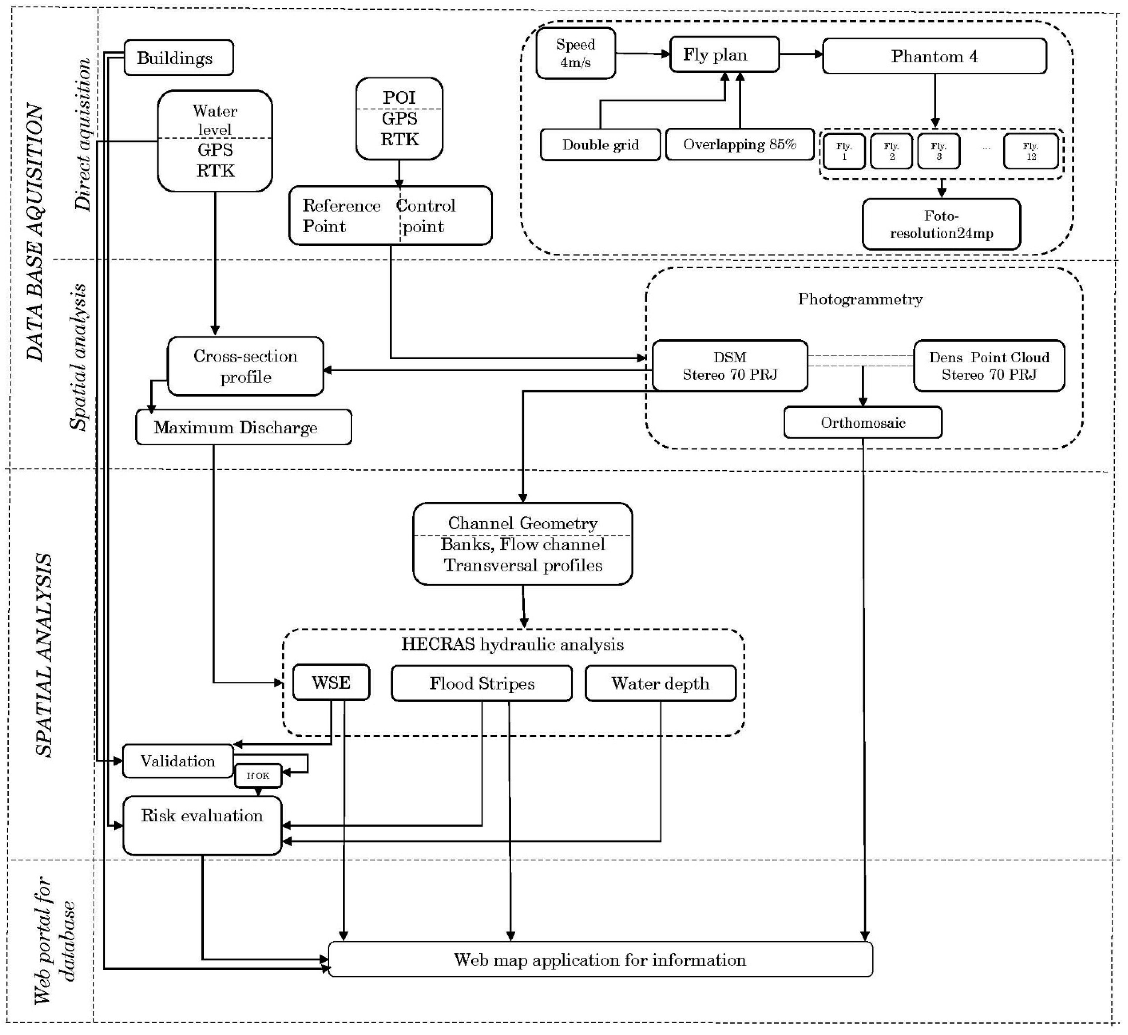
The major challenge raised by the post-event modeling of floods generated by rapid flash floods in hydrometrically undeveloped and uncontrolled river basins necessitates the pursuit of a complex methodology. Thus, a methodology was developed based on 3 stages (Figure 2) meant to highlight the modeling of risk induced by the analyzed flash flood. At the same time, together with the modeled spatial databases, the methodology can provide useful information to the public administration by means of a web app.
The first stage is known in the literature as the post-flood peak discharge estimation [39,40,42,48]. This generally means acquiring the digital databases that the subsequent spatial analysis model is based on. It is composed of two different subsections in terms of the database acquisition manner. It is about (a) the direct acquisition by exploring the reality in the field [39,40,42,48] and (b) the spatial analysis stage outlined as a submodel with its own results [33,41,74]. These results (b) represent input databases in the model that set the bases of flood risk identification.
The acquisition of spatial data that were input in the modeling process was performed in two ways: direct data acquisition and acquisition by spatial analysis. The direct acquisition implied field measurements via GNSS RTK E-Survey E600 and the processing of images acquired by means of a UAV DJI Phantom 4 Pro. The acquisition based on spatial analysis implied the processing of images by the specialized software Agisoft Metashape Professional 1.7.2. This analysis resulted in two sets of data: the orthomosaic and the DSM data. These enabled the vectoring of buildings (the first) and the subsequent modeling (the second). The DSM, together with the levels taken on the buildings, made possible the identification of the maximum flash flood flow. In parallel, the buildings’ footprint enabled the calculation of the risk these were exposed to.
The second methodological stage implied the development of a HecRAS 6.1 hydraulic model (open-source product), which integrated the data obtained in the first stage of territorial analysis [47,75,76,77,78,79]. The obtained data contain the vectorial information, representing the geometry of the riverbed (banks, flow channel, cross-sectional profiles), raster information (the digital surface model) and alphanumeric information (the Manning coefficient, the maximum flow). The integration aimed at achieving useful raster data in the process of risk identification and management (height/depth of water, velocity and shear stress).
The integration of these databases was conducted by the implementation of this 2D hydraulic model based on the diffusion wave equation. The equation was applied on a polygonal grid structure (l = 4 m) in a vectorial database that emphasizes the roughness coefficient. The time step used was 12 s, small enough to ensure the stability of the model. The time step was chosen after running several successive GIS hydraulic analysis models. The model with the time step leading to the best territorial validation results was chosen.
The validation of the hydraulic analysis results was conducted in the spatial analysis stage. The use of the direct validation method (comparing the results achieved with the reality in the field) was applied in this study due to the fact that there were many buildings that could be identified in the field, where the water level of the analyzed flash flood was easy to see. Therefore, the value of the water level identified on a building was compared to the cross-sectional profile of the maximum flow (Figure 3). The building is found on the river bank opposite (the right river bank) to the reference building used for the flow calculation.
The high complexity of the spatial analysis stage was generated by the risk identification methodology. The databases achieved as a result of running the hydraulic model, were integrated in the spatial cognitive analysis. The aim was to identify risk associated with each particular residential territorial infrastructure. The spatial impact of two databases was analyzed in an integrated manner, i.e., shear stress and water height. The results of integration were related to each polygonal structure given by the buildings inside the study area [56,76,80].
The last methodological stage consisted of the dissemination of the final results reflecting the risk associated with the territory. This aims at warning the population and developing an efficient risk mitigation management by the local public authorities, in case of similar events. The dissemination of final results was based on webgis apps. These enable the public to access the achieved databases via a portal, without visualization and access interdictions on the Internet [44,81,82,83,84].
The spatial analysis model is based on a large range of spatial data in different formats and geometries, each data set having a well-established role within the model (Table 1). The database management has the purpose of generating new spatial data structures, resulted by modeling.
The proposed methodology is outlined as a complex spatial analysis model, based on submodels developed for digital data acquisition. The submodels are logically integrated both horizontally, within the distinct methodological stages, and vertically, between stages. Data modeling highlights the territorial impact of risk induced by the analyzed flash flood and helps developing good practices and decision making in SFM.

3. Results

Following the proposed methodology, the applicative results were outlined and divided into two distinct categories. The first category is represented by the support databases for the development of spatial analysis models in the hydrology spectrum. The reference is made here to: (a) DSM as support database for flood risk identification and (b) water flow in the calculation profile, as a database that can be used within hydraulic models. The second category is represented by the results achieved after implementing the hydraulic model and the territorial risk identification methodology (the floodable stripe, WSE, shear stress, velocity, areas of various risk degree). The results in the second category will be used for quantitative and/or qualitative analyses for decision-making purposes and for the information and awareness of the population regarding flood risk.

3.1. Acquisition of GIS and Alphanumeric Databases Based on UAV Techniques and Hydrological Calculation

The delimitation of the floodplains and the analysis of the risk induced by floods are stages of vital importance. Given that there are no detailed topographic measurements to evaluate the small river basins, the main method of analysis is to reconstruct the flow for the hazard that generated it. Flow reconstruction is a complex process that is based on the assessment of field data measurements (cross-sectional profiling) and direct observation of flood effects (identification of water level on housing infrastructure and its measurement). In the current context of digitization and management of GIS spatial databases, the reconstitution of the flow associated with the flood analysis can be performed faster, and a highly correct flow value can be obtained if correct databases with high spatial resolution are used in this process.
In order to calculate the flood flow, reliable cross-sectional profiles are required, which can be difficult to obtain based on traditional topographic surveys. In the present case study, modern implementations were used such as DSM and raster databases with high resolutions and very high representation accuracies. For this purpose, and in the case of small river basins for which the local public administration does not have such database and accurate measurements, the suitable solution is the UAV and geomatics techniques that allow an efficient mapping of databases in terms of short time and at a superior quality for further implementations in GIS models of spatial analysis.
Taking into account that the entire methodological process is based on exploiting the digital databases, an important stage was represented by the acquisition of the digital surface model for the entire study area. It was important that the DSM had a high resolution and high precision.
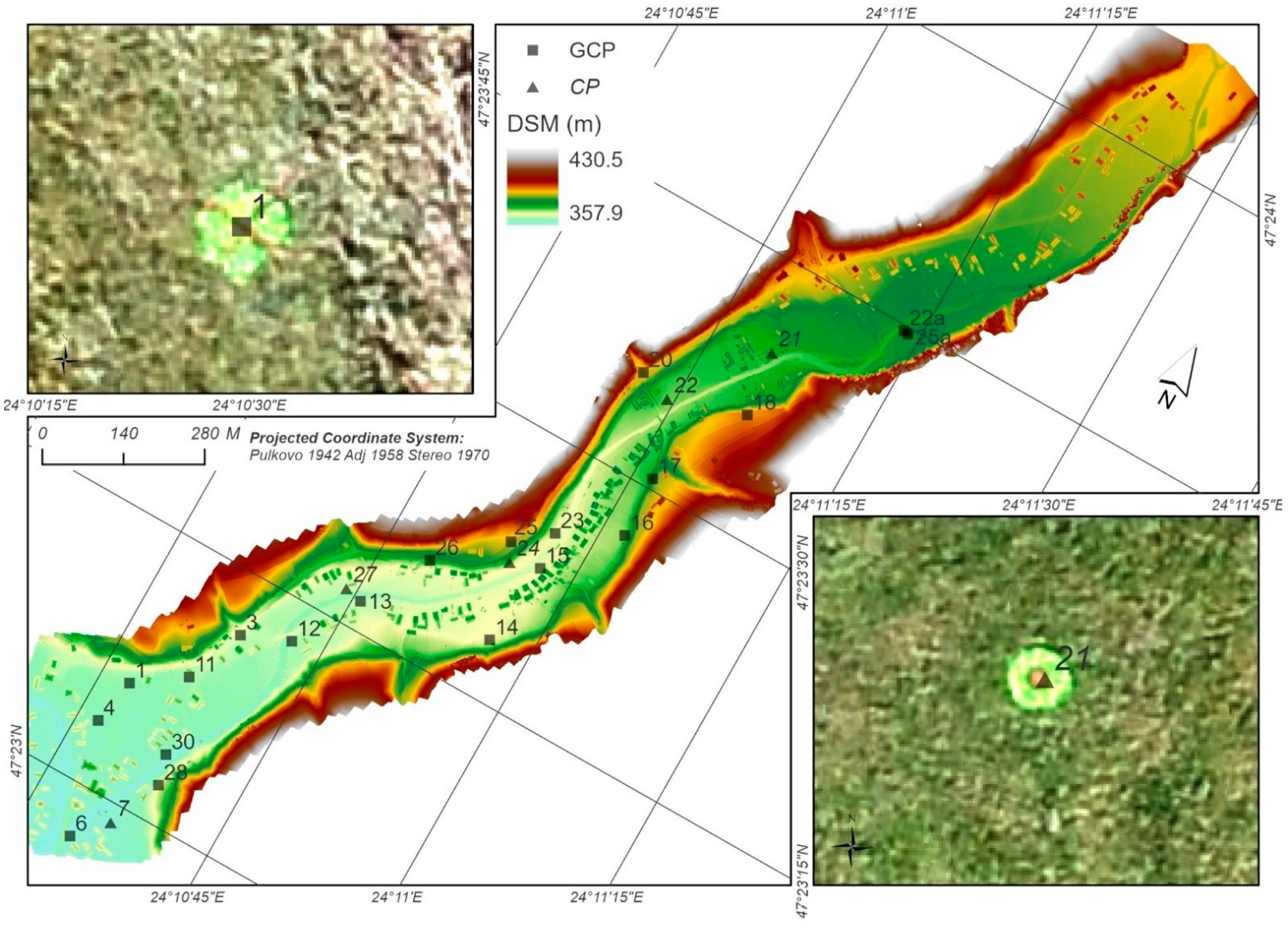
The direct acquisition implied the identification of ground control points (GCPs) and control points (CPs). The control points are useful in the georeferencing process of the photographs and increase the precision of the final representations. In the entire study area, 23 points were measured. Of these, 18 points were used in the georeferencing process (GCP), and 5 points were used for the estimation of positional accuracies of representations (CP) [85]. The control points were taken in the Stereographic 1970 projection system, using a GNSS RTK E-Survey E600. In recent decades, GNSS systems became the perfect choice for topographical surveys and precise measurements of points on the surface of the Earth for us as geo-references. GNSS systems are conditioned to optimal field conditions such as sufficient satellite availability, network RTK services and open fields [86]. Also in this stage, the buildings in the analyzed area were vectorized in order to be used in the validation of the floodable stripe and in the risk identification for the territorial infrastructures (Figure 3).
A number of 12 flights was necessary for the entire study area (0.71 Km2). The flight plans were developed using the Pix4Dcapture software. The UAV was represented by a DJI Phantom 4 Pro, with a 24 MP photo camera. Highly accurate final results required the use of specific flight parameters. The flight metrics were as follows: 90 m altitude, 85% overlap, 90° camera angle, 4 m/s average flight speed, polygon mission and approx. 16 min flight duration.
As a result, 2542 images were acquired and processed in Agisoft Metashape Professional 1.7.2. The resulting errors were: 0.023 m E, 0.019 m N and 0.056 m altitude. The resulting products were: dense point cloud (464,038,762 points), the DSM (4.65 cm resolution) and the orthomosaic (2.32 cm resolution). Their characteristics recommended them for the use in the following stages.
The study area may be affected by phenomena recorded on a surface of 59 km2 (mountain and hill area with max. altitude of 1489 m a.s.l. and min. altitude of 360 m a.s.l.), the surface of the Izvor river basin. The only hydrometric station is 36 km downstream at the influx of the Ilișua river (352 km2) in the Someșul Mare River. In case of rainfalls affecting the entire basin, the hydrometric station is no longer relevant for our study area. Yet, the event in 2006 recommends it as useful, with the corresponding error margin. However, the reconstruction of the maximum flash flood flow was chosen using the visible water level on the buildings affected by the above-mentioned event (Figure 4).
The calculation of the maximum flood rate is based on the Manning formula, based on the metrics obtained from the UAV-derived DSM database. The calculation section was selected in the southeastern part of the study area, using one of the buildings on the right bank of the river, where there are still indications of the level recorded during the 2006 flash flood. The validation of the floodable stripe and its corresponding level was performed on a building on the left bank, located on the profile. The tracing of the cross-sectional profile was conducted in compliance with the technical requirements for the hydrometric studies, perpendicularly on the river network and tangentially to the residential infrastructure considered as reference.
For the calculation of the maximum flow of the flash flood and its insertion as an alphanumerical database in the hydraulic simulation model, the water level related to the altitude of the drainage channel thalweg was used. To achieve the water depth and level, GNSS RTK measurements were conducted for the identification of the reference building’s footprint (367.2 m) and the water height on the respective building (1.16 m). The drainage channel thalweg’s altitude (365.051 m) was achieved based on the cross-sectional profile. This was drawn based on the obtained DSM. Based on the altitude values presented, the water level (3.309 m) was achieved, and it was used to calculate the maximum flow in the section. By means of the hydraulic toolbox software, the value of the maximum flow (333,559 m3/s) of the analyzed flash flood was acquired. The flow was calculated taking into consideration the slope of the flow channel 0.01 m/m (the slope calculated in the field) and a Manning coefficient of 0.060.

3.2. Hydraulic Modeling for Delimitation of Floodplains and to Support Databases for Flood Risk Identification

The component analysis, such as the water height, shear stress and the velocity revealed the impact on the anthropic components of the territory. The integrated analysis of the presented components reflected various risk categories, starting from which potential risk reduction solutions can be drawn.
As a result of implementing the GIS hydraulic analysis model, in addition to the spatial extension of the floodable stripe, a raster database illustrating the height (depth) of the water inside the floodable stripe was obtained.
The fact that the analysis conducted and the development of the entire complex spatial analysis model was based on the reconstruction of an event facilitated the validity of the entire model and supported the conclusions and the recommendations that were issued. The results of this material become a land use planning tool. Validation also stressed the efficiency of choosing the 12 s time step in the 2D hydraulic dynamic model. It was conducted by directly comparing the results (water level) with the visible effects of the flood on the buildings in the affected area, and it has the value of 5.4 cm water height/depth (1.502 m modeled value and 1.448 m measured value). The validation of the model enabled the component analysis of the final results. The component analysis was conducted both for the entire area and for two representative frames in terms of flood effects.
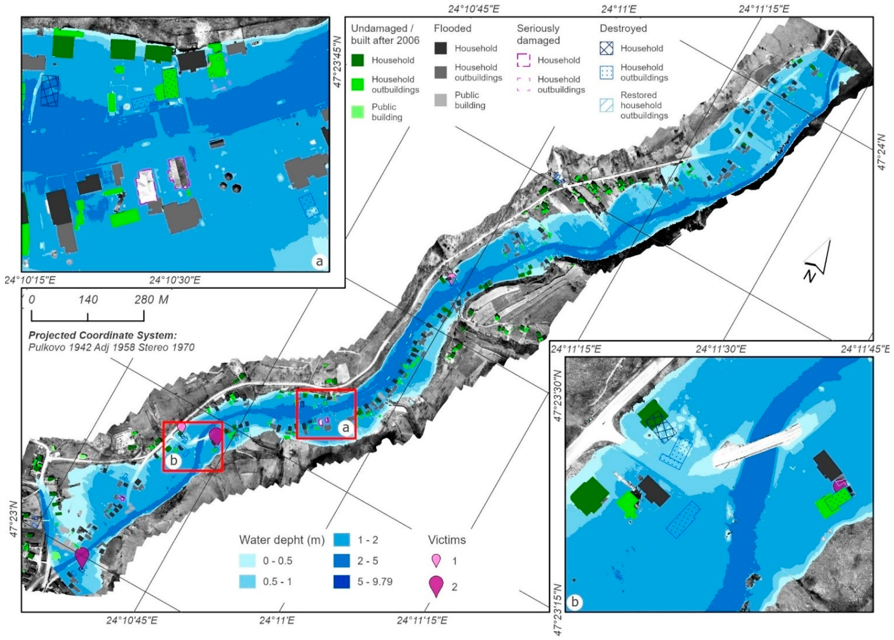
The water height analysis at the maximum flash flood flow reflected higher values in the thalweg areas, in the minor and major riverbed areas. Small values are specific for the larger sectors and toward the slopes. The central-southeastern part of the study area is characterized by high water heights in the context of smaller values of the riverbed width. Unfortunately, the highest building density is also recorded here. This high value is associated with the technical and urban infrastructures, with implications, as we shall see, for the dimension of the associated risk (Figure 5 and Video S1).
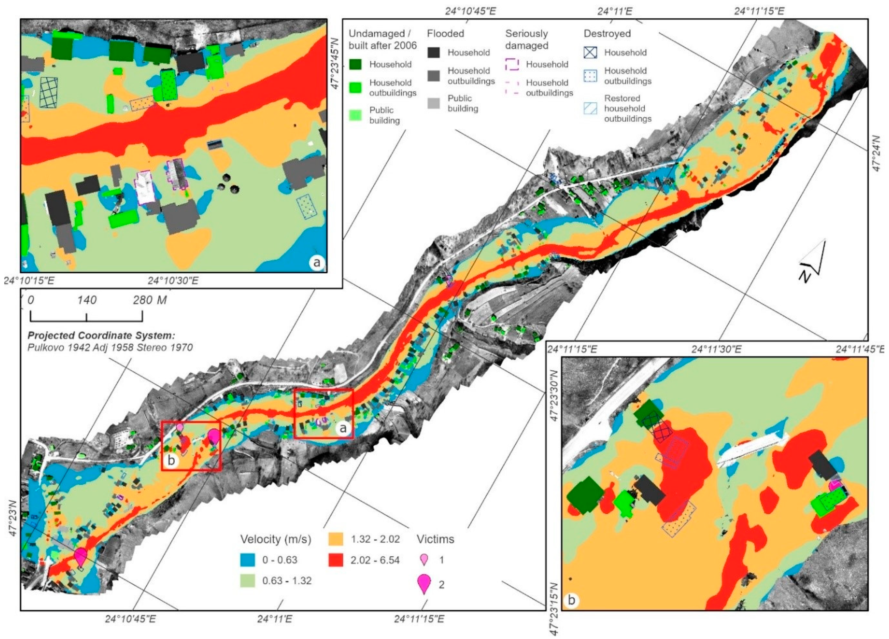
The analyzed flash flood had a significant impact on the buildings (n = 225). Most of the buildings and their associated infrastructures are located in the meadow (the major riverbed). As the buildings are closer to the slopes and/or as the meadow becomes wider, the impact on the buildings is lower (128 buildings for the 0–0.5 m interval and 53 buildings for the 0.5–1 m interval). The impact considered to be very high is visible for a relatively large number of buildings spatially overlapping the water height interval over 2 m. These are all positioned in the sector where the meadow records smaller height values, such as in Figure 5a. During the event, values not highlighted in the results of the modeling might have been recorded. A possible example is presented in Figure 5b, to the right of the watercourse, where, in the area of the three destroyed buildings, it is possible to deal with higher values of water height while the bridge was blocked and the watercourse was diverted to the right. The blocking of bridges, in flash flood situations, causes negative effects in the immediate proximity. This also happened in the cases presented in Figure 5b, on both sides of the bridge. Six persons were carried away by the flash flood here. Three of them unfortunately did not survive, not necessarily because of the water level but due to a combination of factors.
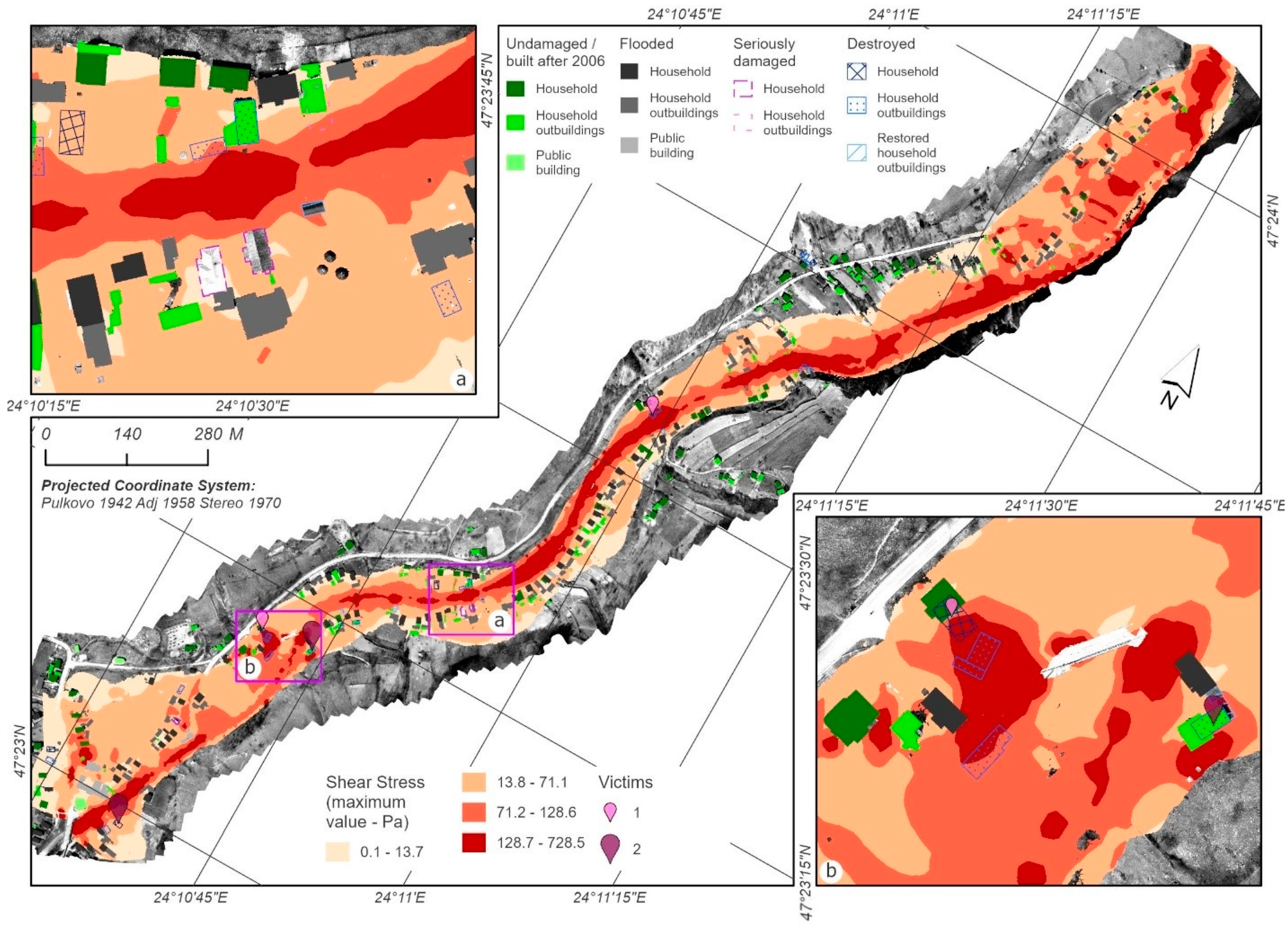
The impact on the residential buildings also increases because of the building materials and techniques that were used, making them more or less resistant to flash floods [87,88,89]. At the time of the event in Târlișua, most of the buildings were made of wood or burned brick, with no additional protective structure. To capture the force of the flash flood exercised on the buildings, the Shear Stress was modeled for the floodable stripe associated to the maximum flow [77,80] (Figure 6).
In addition, for a better territorial analysis of vulnerability and impact, the water velocity was also modeled for the maximum flow [47,56,73,74,76,77,78,79,80] (Figure 7). The two databases were analyzed correlatively to reveal the cumulated impact of the two processes and the response provided by the affected infrastructures [77].
The analysis of the entire territory subjected to modeling reveals a high shear stress in the minor riverbed areas and in the areas in its immediate proximity. The shear stress is correlated to water velocity, and therefore, the latter also has high values in the minor riverbed and in its proximity (Figure 6). The high velocity modeled on the slopes in the immediate proximity of the riverbed has a powerful erosion effect, disrupting sedimentary material that it transports and then deposits in the narrow parts of the riverbed forming natural dams. These dams favor the backwater process and the increase in water level upstream. Moreover, if these dams fail, an increase in the flow may occur, with negative effects. Due to the high velocity and shear stress applied to the building materials and the wood material stored near the major riverbed (but also due to the materials carried from upstream or by the torrents not considered in the analysis), a phenomenon similar to the debris flow develops. This carries heterogeneous elements, storing them in the bridge area, behind the more resistant buildings or in areas with smaller flow velocities. At the same time, the materials that are carried away increase the destruction capacity of the infrastructure elements manifested by the flash flood wave [90].
The effects of the two flash flood parameters (shear stress and velocity) are visible, thus suggestively validating the two case studies (Figure 6 and Figure 7). The first parameter overlapped a segment of a narrower meadow, where the high shear stress (over 50 Pa/s/m2) is associated with a proportional water velocity (over 1 m/s/m2) (Figure 6a and Figure 7a). During the event, three houses were damaged (two of them were subsequently repaired), as were two barn-type buildings and other household annexes of smaller value. Many other buildings in the area were flooded. In this case, the materials swept away by the flash flood also had an impact. These made it possible to destabilize and break the walls of the buildings. The second detail (Figure 6b and Figure 7b) highlights the role a bridge can play in a flash flood, especially if it is blocked by the carried away materials, becoming a real dam. With values of shear stress higher than 128 Pa/s/m2 and a water velocity higher than 2 m/s, two houses and three household annexes were destroyed. Moreover, six persons were carried away by the flash flood. Three of these were not able to save themselves (all three were women).
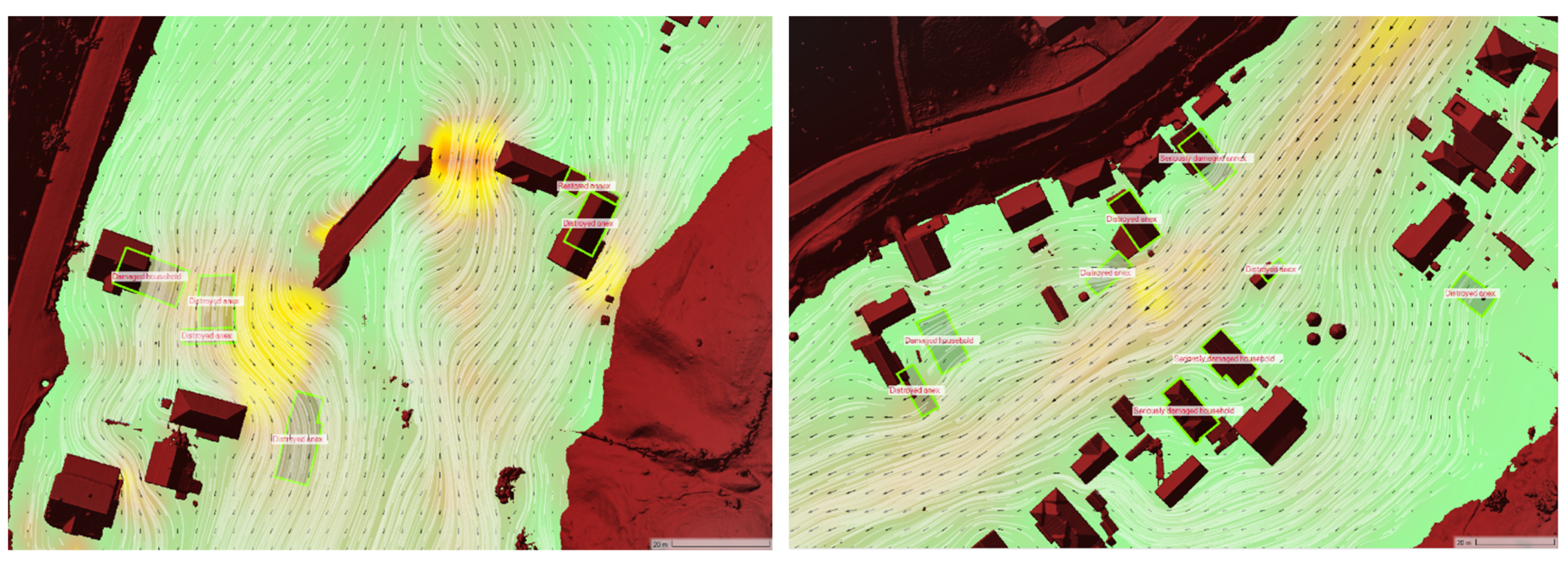
Figure 8 reflects, once more, the negative effects generated by the cumulation of the two factors: shear stress and velocity (Videos S2 and S3). All types of buildings were affected (wood structures, masonry or autoclaved aerated concrete structures). The buildings constructed subsequent to the event are more solid, with concrete foundations, not stone, and with structural frames (beams) also made from concrete.
Even if we speak about variable segments of the meadow, in terms of width, the values are relatively small. In case of flows such as the one recorded in 2006, the water floods the entire meadow. We believe this fact facilitates the occurrence of a directional influence manifested by slopes on the flash flood parameters. The change in direction is made especially where the watercourse comes into contact with the slope, including at average flow. This can explain why, in certain places, more buildings closer to slopes were destroyed than those closer to water, even belonging to the same household. Beside the implications of the meadow and slope morphometry, there are also implications at microscale level. This is the case of bridges (as mentioned above) or more solid buildings, which can deviate the current, leading to an increase in the parameter values sideways and a decrease in these values in the discharge direction. We can imagine them as small dams in the path of the flash flood, some of the materials that are carried away by water accumulating behind them, thus increasing their resistance.
The component analysis, as well as their correlative analysis, has validated the spatial analysis model proposed by the identification of the critical areas in the same sectors with the territorial elements destroyed after the occurrence of the analyzed flash flood. This fact enabled the transition to the final step of spatial analysis, that of assessing the territorial risk, based on the management of output data from the implemented hydraulic model. The modeling of the floodable stripe and the associated parameters facilitated the integrated analysis of the territory and enabled at the same time the identification of the critical areas and the assessment of risk induced to buildings.

3.3. Risk Assessment Methodology

Risk assessment is the main stage of territory analysis, useful for local public administrations. The identification of the risk areas affected by floods in Romania is conducted by taking into account the European Flood Directive 2007/60/EC. According to this directive, each member state of the European Union can develop its own methodology depending on the local specificity. In Romania, floodable stripes were drawn based on a hybrid methodology, whose background model is the quantitative risk assessment model proposed by the Flood Risk and Damage Assessment using modeling and Earth Observation Techniques [1,91].
The methodology presented in this study takes into account the one applied in Romania and the one proposed by the Ministry of Land, Infrastructure, Transport and Tourism in Japan, amended [73,92,93]. The majority of the flood risk identification methodologies omit shear stress as a factor of risk. For this reason, the following situations emerge when it comes to selecting the parameters: (a) only the height of the water is taken into consideration [50]; water height and velocity are chosen [56,73,74,76]; (c) in addition water height and velocity, there is also the stream power [47,78]; and the velocity, shear stress and stream power are chosen [77].
The described methodology took into account the height of the water and the pressure it exerted on the buildings and other elements in the territory, as well as the shear stress. The need to consider this indicator derives from the fact that many of the victims of the floods were also carried away by the flash flood from the buildings they took shelter in. In addition to the nine victims swept away by the flash flood from their own buildings, there were other persons in the same situation, but ultimately, they managed to save themselves (at least two). In addition, several persons survived in the flooded houses, which can be considered a relevant indicator for citizens’ relation to buildings as a possible defense structure against the flash flood.
Given the lack of data to perform a probabilistic statistical analysis and the identification of the return probability for different rainfall and flood scenarios, we propose to make hazard maps for singular major events, events for which the databases obtained by post-event spatial modeling and analysis highlight both the quantitative and qualitative impact in the territory.
Four classes of hazard were identified: small, medium, large and very large (Table 2). We believe these four classes highlight the potential territorial impact very well.
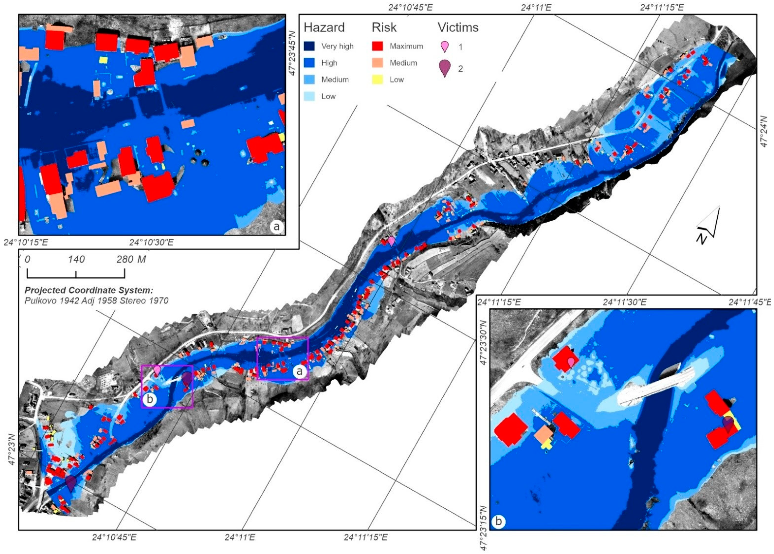
The hazard map resulting from the flash flood modeling enables the analysis of the hazard distribution in the territory and the distribution of vulnerable houses by the four categories of hazard. The correlative hazard–vulnerable building analysis illustrates the correlation of results (Figure 9). The largest territorial expansion in the floodable stripe (hazard) is represented by the large hazard category (56% of the total surface), where 69% of the buildings are found. This situation is due to the closeness of the buildings to the minor riverbed (Figure 9). In its turn, this positioning is explained by the need to access the watercourse and the road, which follows the river path closely. The elderly persons remember that the houses of their childhood were positioned closer to the contact with the slope and therefore at a greater distance from the water. This position qualifies them in the lower hazard classes. The changing in the households’ position is explained, on the one hand, by the changes that occurred during the last century in the economy of the area and on the other by the increased pressure on the lands in the circumstances of the demographic evolution.
The medium and very large hazard classes with territorial expansion of approximatively 19% within the floodable stripe, correlated with a proportional extension of the vulnerable houses (13% very large hazard and 12% medium hazard), completes the image created by the major percentage of the large hazard class. The small hazard category is characteristic for small areas (6% of the total areas exposed to hazard) in the northeastern and southwestern part, where the meadow has a more generous expansion. Some of the buildings (6%) are located in such an area, most of them are household annexes (Figure 9).
The final risk assessment was conducted based on a matrix that also considers the relation of the mapped buildings to the hazard categories and the possible consequences. To develop the risk matrix, the financial losses caused by floods were taken into consideration (Table 3). Information referring to the construction costs per surface unit (m2) associated with the Târlișua commune were obtained from the regulations provided by the Order of the Public Notaries, based on the market study regarding the real-estate fund in Bistrița Năsăud county, 2021. According to this study, the construction cost per m2 of the buildings in the villages near the Beclean Municipality jurisdiction area (where Târlișua is also located) is RON 380/m2 for buildings made of wood or clay and RON 800/m2 for constructions made of stone, masonry or autoclaved aerated concrete.
The same source provided the financial value per m2 for household annexes: RON 440/m2 for constructions with metal structure frame; RON 500/m2 for constructions with concrete, masonry or autoclaved aerated concrete structure frame; RON 74/m2 for wood and metal plate buildings; and RON 58/m2 for stone buildings. Subsequently, we decided to use the average risk assessment value for houses (RON 590/m2) and for household annexes (RON 274/m2). The final assessment was expressed in EUR, related to the surface of each analyzed building, with a RON/EUR exchange rate of 4.99.
As a result of applying the proposed matrix, buildings classified into the three risk categories were identified. There were 89 buildings in the low-risk class, that is, 29% of the total number of buildings located in the floodable stripe. For these, it is recommended to conduct information campaigns for the population referring to risk management on evacuation of buildings, as well as structural and non-structural measures for the mitigation of flood effects. In total, 69% of the number of buildings in the floodable area are classified in the medium and high-risk classes, which reveals the high exposure degree of the studied area to possible future hazards. More precisely, for 112 buildings (36% of the number of buildings), information campaigns are necessary, as well as works for the recalibration and stabilization of the riverbed and other structural protection measures. A similar percentage, 35% (106 buildings), is classified in the medium-risk class. Considering that these are located in the major riverbed, at the foot of the slopes, it is recommended to inform the population on the measures needed for slope runoff mitigation and for torrent-remedial works.
The significant reduction in risk can be achieved by its integrated management on behalf of the local public administration. This implies the adoption of technical norms for the new buildings, for example, encouraging the use of techniques and building materials to increase the resistance of buildings to the pressure force of the flash flood flow. The continuous monitoring of the hazards generating maximum flows adds to all these, especially high-intensity rainfall, the monitoring of the response of the river basin to these hazards and the development of an integrated real-time warning system [44,82].
The local public administration is the main risk management authority at the local level. Among other attributions, it also deals with the identification, mapping, management and information of the population before the event regarding the potential impact of a flood. This study also aims at emphasizing the post-event information aspects, which increase the degree of awareness in the population regarding the effects caused by floods. In this regard, an open access portal was created, which enables the visualization of the floodable stripes, the hazard categories and the risk classes for buildings.
The presentation by the local public authority for the purpose of informing and raising awareness of the flood-induced risk to the population and the main stakeholders is one of the main stages in the integrated risk management plans. The databases generated as a result of the implementation of the spatial analysis model and the application of the proposed methodology can be made available for viewing and information based on maps in classic format through web sites, as well as through mobile applications running on various operating systems. Identifying this need for the local public administration from Tarlisua commune, it was decided to create a geoportal to present the concrete results with validated territorial applicability in order to add value in terms of the degree of digitalization of the local public administration.
The portal, a webGIS app for, but not exlusive to, the local administration, can be accessed at the following link: https://geoubb.maps.arcgis.com/apps/View/index.html?appid=b85f1b67914a4cae881816e8b3aa60e6, accessed on 13 January 2022. The input and update of the database available in this version need access accounts via ArcGIS Online and the medium level in terms of managing the data in the GIS platform. The subsequent variants of this portal may also integrate the possibility that the inhabitants propose changes in the data, especially in terms of their property.
The modeling of the floodable stripes for extreme events represents one of the main operations conducted by the specialized departments within the public administrations (local and/or regional). The purpose is to inform the population in order to reduce the risk and its effects. The freedom of the local public administration is an advantage when it comes to developing GIS apps meant to facilitate the efficient management of the risk phenomena, including floods.

4. Discussion

Since the turn of the century, society has welcomed digital transformation, but this technological revolution was not experienced equally. There is a power to being able to control data, and improving the capacity to interpret data is a fundamental step towards global equality. Even those outside of institutions need the ability to access scientific results, as well as training in data skills. It will serve as an advantage to society to be able to correctly interpret digital resources and be able to contribute to science.
Flood risk assessment implies, firstly, the use of a national framework methodology and then its development depending on the particular, regional and local conditions. In contrast to other case studies conducted for the analyzed area [62,63,64,65,66,67] highlighting the intensity and damages caused by the flash flood on 20 June 2006, this case study stands out by the methodology it applies. This takes into account the interrelationships between the components generating risk, assessing in a much more correct manner the vulnerability, the exposure degree and the risk on buildings. The three parameters (water height, velocity and shear stress) used in combination and modeled on a high-resolution DSM, offer information that corresponds to reality, according to result validation. The utility of this model in large-scale land use planning is therefore emphasized.
The calculation of the shear stress induced by the flash flood on the buildings represents a live issue, which is very useful in flood hazard and risk assessment studies. The value of the result increases by entering, as input data the information on the building materials and the nature of the structural frame of the buildings. The study proposes a hybrid methodology that enables both the financial assessment of material losses to the buildings and the assessment of the life loss occurrence probability. This can be filled in with more detailed information regarding the characteristics of the buildings and the social dimension of the households.
The risk assessment was conducted on buildings by taking into account the economic value (cost/construction), considering the area corresponding to the building footprint. The costs were obtained after analyzing the market study on the real estate found in Bistrița-Năsăud County. The exploitation of this document eliminates subjectivity in terms of risk assessment, classifying the study in the territorial quantitative risk assessment category [94].
Improvement in the proposed methodology can be made, in the future, by excluding subjectivity from risk assessment to the highest extent possible. Therefore, this will quantify not only the built area as footprint, but the entire built area, including the objects inside. The objective risk assessment methods for buildings correspond to one of the five principles for climate-proof municipalities and cities: principal no. 4, Promote climate safety of buildings [95].
The information and awareness policies regarding the effects of such an event, their probable impact and the ways to evacuate the population are based either on post-event analyses (such as in this case) or on the closest events in terms of manifesting conditions. The availability of detailed, graphic (2D, 3D maps, virtual reality) information for the decision-makers and for the population represents an important element. Without this element, it is difficult to imagine an efficient risk-awareness campaign nowadays. The initiation of a portal to enable the building level visualization of the flood risk is an added value.
In addition to presenting the buildings with their various risk classes, the portal makes the hazard map available to the local public administration and to the population. This feature enables the documentation and assessment of possible losses recorded by various technical and urban infrastructures, by the agricultural lands, etc. In perspective, this feature is intended to be made editable also for the inhabitants. Many local administrations adopt technical innovations such as websites, while their implementation is achieved as a unidirectional source of information for the residents with Internet access [22].
We consider that some river basins, such as Ilișua, where such water-related events took place to such an extent, may be included by the National Institute of Hydrology and Water Management on the list of representative or experimental basins (The Experimental Hydrology Department). For this purpose, national funds can be accessed by the academic institutions, but not exclusively, following the Schöttlbach creek (Switzerland) model [96]. In such an area, flood management systems can be tested [97], which can subsequently be implemented at the national level. Combinations of UAVs and other categories of sensors can also be tested in such a basin [74], or Innovative Tools can be implemented, such as GOWARE—Innovative Tool for the Management of the Surface Drinking Water Resources at European Level [98]. The existence of some scenarios based on complex and detailed data, some of them captured with UAVs, can be essential tools for flood management in DEGs. The scenario method is also suitable for the development of public policies [99,100,101].
Although the role of UAVs in remote sensing is widely known, the short time of flood occurrence and the lack of UAV resources near the affected areas have restricted the rapid response of these systems in emergency rescue. The creation of a UAV remote sensing observation network on a regional scale is recommended. The drone ports should be located at a maximum 2 h flight distance from the most affected areas, a critical position for saving lives and mitigating losses [102]. This infrastructure can also be used for emergency response. In periods without such situations, the infrastructure can be used to improve the pre-disaster database.
The results obtained and established in alphanumeric (flood flow, construction costs per surface unit) and spatial (DSM, flood band extension, water level, water flow rate, orthophoto plan) databases will be used as a basis for new research which we will develop for the studied area, that is, research that will highlight changes in the use of land, the associative risk of infrastructure in relation to the inhabited area and losses due to the destruction of the infrastructure.
Future studies in the areas will focus on the flood risk identification in technical and urban infrastructures (by assessing the recovery/repair cost), buildings [59], agricultural lands [103], etc. These studies will enable the diversification and detailed description of the information available on the initiated portal. Subsequently, the responsiveness of the local public administration and the population to such graphical forms of data presentation will be analyzed.
One of the follow-up directions of the study focuses on the improvement in the social vulnerability index (SoVI) [104] by increasing the analysis detailing degree (testing in the household). The details can include the identification of families that are more susceptible to losses and, therefore, this can lead to the increase in local community assistance [105,106,107,108,109]. Moreover, the risk maps should set the basis for decision making, by making the community aware about them.
UAVs should be seen as data sampling tools, components of a wider range that includes TLS (Terrestrial Laser Scanner) [110], sensors within the hydrometric stations, meteorological radars, etc. Using as many sampling and processing tools as possible enables and the spatial analysis of a basin from several points of view (hydrological, meteorological, geomorphological, etc.) [96,111,112,113].
The study directions also come from the shortcomings of the study and from the possible perspectives. The remaking of the model is performed based on information achieved by using the LiDAR on a UAV. The higher quality of the information in vegetation areas is already proven [114,115], with a detailed modeling of bridges and materials carried away during the flash flood [90,116].
The development of such models and methodologies favors the implementation at the local administration level of some best practice examples in terms of integrated flood risk management, especially by using nature-based solutions [117,118]. At the same time, these models support participatory efforts. In this general framework, we see so evidently the following statement: “capacity building, digital inclusion and open infrastructure are needed to enhance participatory citizen science and mapping tools” [119]. The transfer of some best practice models implies not only technological changes but also a fundamental change in culture and governance [120].
This material makes new steps towards satisfying the need for transdisciplinary cooperation [121]. The following types of collaboration may be accomplished: (a) collaboration for the study of various natural hazards (multi-hazard events) [122], (b) collaboration across natural and social sciences and (c) collaboration between scientists and practitioners [123]. Administrations are included here, regardless of their level, together with partnerships between universities and local communities.

5. Conclusions

This study belongs to the category of mandatory interpretative studies for flood-adapted land use decision making. Such a study highlights areas of low adequacy in terms of residential use. This information should document the decisions taken by the local administration and by the population at an individual level.
The proposed methodology can also be implemented in territories where there are no available spatial data resulting from measurements at hydrometric stations. The replicability capacity is important. For the small river basins, the measurement points of discharge are missing (except the experimental posts), with direct implications in the calculation of flash flood hydrograph. This is the reason why the maximum flow was emphasized, by using the DSM and the cross-sectional profile obtained based on the UAV platforms with sensors. Thus, some credible working tools were provided for hydraulic modeling. The identification of the flow value for the maximum flash flood, by exploiting the digital surface model and the cross-sectional profile obtained from the DSM, is one of the main stages of the current study.
The integration of the UAV techniques in the risk modeling and assessment process is absolutely necessary when the public local administration pursues the pre-event risk assessment. The lack of the main spatial databases setting the basis for the flood models (DSM, Land use, buildings’ footprint) underlines exactly the need for these accessible and increasingly available techniques. The development of the three-dimensional model of the relief by photogrammetry or LiDAR generates results with a satisfying accuracy (in our case: 4.65 cm/pixel for the DSM and 2.32 cm/pixel for the orthomosaic model). Once these databases are compiled, the local public administration can use them in other associated risk assessment projects (landslides, soil erosion, etc.), without investing time and generating additional costs for their purchase.
It was noticed that there is also a problem in terms of data on the topography of the river basin. Filling in this gap in the databases at a national level was possible by the use of the UAV techniques in the DSM generation process. The model facilitated the calculation of the flash flood flow and the generation of the cross-sectional profiles used in hydraulic modeling.
The proposed model pointed out three important problems in risk assessment: water height in the profile (for the identification of the possible drowning areas), shear stress (for the identification of collateral victims) and cost per construction in order to assess the dimensions of the economic losses. While the first two elements enabled hazard analysis, which was modeled at the spatial level for the entire study area, the third element is the basis for calculating the specific risk depending on the purchasing power or market value of the inhabitants in the analyzed area.

Supplementary Materials

The following supporting information can be downloaded at: https://www.mdpi.com/article/10.3390/rs14102481/s1, Video S1: Water level for floodable stripe; Video S2: Cumulative effects of shear stress and velocity for study area A.; Video S3: Cumulative effects of shear stress and velocity for study area B.

Author Contributions

Conceptualization Ș.B.; methodology Ș.B. and G.-G.H.; software S.R., I.F. and V.I.; validation A.-M.P., A.-C.M.-P. and P.S.; formal analysis Ș.B.; investigation G.-G.H. and P.S.; resources A.-M.P. and A.-C.M.-P.; data curation I.F. and V.I.; writing—original draft preparation A.-M.P., A.-C.M.-P. and G.-G.H.; writing—review and editing Ș.B. and G.-G.H.; visualization S.R.; supervision Ș.B.; project administration Ș.B.; funding acquisition G.-G.H., V.I. and I.F. All authors have equal contribution to this work. All authors have read and agreed to the published version of the manuscript.

Funding

This paper has received financial support through the project “Entrepreneurship for innovation through doctoral and postdoctoral research”: POCU/380/6/13/123866, a project co-financed by the European Social Fund through the Operational Program for Human Capital 2014–2020, and the present work has received financial support through the 2021–2022 Development Fund of the Babeș-Bolyai University.

Data Availability Statement

Not applicable.

Conflicts of Interest

The author declares no conflict of interest.

References

  1. Chendeş, V.; Bălteanu, D.; Micu, D.; Sima, M.; Ion, M.B.; Grigorescu, I.; Persu, M.R.; Dragotă, C. A database design of major past flood events in Romania from national and international inventories. Air and Water Components of the Environment. In Proceedings of the Conference: Air and Water Components of the Environment, Cluj, Romania, 20–22 March 2015. [Google Scholar] [CrossRef]
  2. Amponsah, W.; Ayral, P.-A.; Boudevillain, B.; Bouvier, C.; Braud, I.; Brunet, P.; Delrieu, G.; Didon-Lescot, J.-F.; Gaume, E.; Lebouc, L.; et al. Integrated high-resolution dataset of high-intensity European and Mediterranean flash floods. Earth Syst. Sci. Data 2018, 10, 1783–1794. [Google Scholar] [CrossRef] [Green Version]
  3. Wang, X.; Xie, H. A Review on Applications of Remote Sensing and Geographic Information Systems (GIS) in Water Resources and Flood Risk Management. Water 2018, 10, 608. [Google Scholar] [CrossRef] [Green Version]
  4. Arshad, B.; Ogie, R.; Barthelemy, J.; Pradhan, B.; Verstaevel, N.; Perez, P. Computer Vision and IoT-Based Sensors in Flood Monitoring and Mapping: A Systematic Review. Sensors 2019, 19, 5012. [Google Scholar] [CrossRef] [PubMed] [Green Version]
  5. Kam, P.M.; Aznar-Siguan, G.; Schewe, J.; Milano, L.; Ginnetti, J.; Willner, S.; McCaughey, J.W.; Bresch, D.N. Global warming and population change both heighten future risk of human displacement due to river floods. Environ. Res. Lett. 2021, 16, 044026. [Google Scholar] [CrossRef]
  6. Sayers, P.; Li, Y.; Galloway, G.; Penning-Rowsell, E.; Shen, F.; Wen, K.; Chen, Y.; Le Quesne, T. Flood Risk Management: A Strategic Approach. Edited by UNESCO. Paris. 2013. Available online: https://www.wwf.org.uk/strategic-water-management#flood-risk-management (accessed on 19 March 2021).
  7. UN. Transforming Our World: The 2030 Agenda for Sustainable Development. Available online: https://sdgs.un.org/2030agenda (accessed on 19 March 2021).
  8. National Research Council. Disaster Resilience: A National Imperative; The National Academies Press: Washington, DC, USA, 2012. [Google Scholar] [CrossRef]
  9. Directive 2007/60/EC. Available online: https://ec.europa.eu/environment/water/flood_risk/ (accessed on 20 March 2021).
  10. Sahay, A.; Kumar, A.A.; Pongpaichet, S.; Jain, R. Multimedia Rescue Systems for Floods. In Proceedings of the MEDES ‘17: The 9th International Conference on Management of Digital EcoSystems, Bangkok, Thailand, 7–10 November 2017; pp. 210–215. [Google Scholar] [CrossRef]
  11. Gooch, R.; Chandrasekar, V. Integration of real-time weather radar data and Internet of Things with cloud-hosted real-time data services for the geosciences. (CHORDS). In Proceedings of the 2017 IEEE International Geoscience and Remote Sensing Symposium (IGARSS), Fort Worth, TX, USA, 23–28 July 2017; pp. 4519–4521. [Google Scholar] [CrossRef]
  12. Martin, C.; Kamar, O.; Berzosa, I.; Badiola, J.L. Smart GIS platform that facilitates the digitalization of the integrated urban drainage system. Environ. Model. Softw. 2020, 123, 104568. [Google Scholar] [CrossRef]
  13. Da Silva, L.B.L.; Alencar, M.H.; de Almeida, A.T. Multidimensional flood risk management under climate changes: Bibliometric analysis, trends and strategic guidelines for decision-making in urban dynamics. Int. J. Disaster Risk Reduct. 2020, 50, 101865. [Google Scholar] [CrossRef]
  14. Niedzielski, T.; Witek, M.; Spallek, W. Observing river stages using unmanned aerial vehicles. Hydrol. Earth Syst. Sci. 2016, 20, 3193–3205. [Google Scholar] [CrossRef] [Green Version]
  15. Koschitzki, R.; Schwalbe, E.; Krohnert, M.; Cardenas, C.; Maas, H. Multi-temporal photogrammetric analysis to monitoring the river Las Minas, Punta Arenas, Chile. IEEE Lat. Am. Trans. 2018, 16, 2481–2489. [Google Scholar] [CrossRef]
  16. Ștefanescu, V. Decision support system based on the history of flood and flash flood events in Romania. Nat. Hazards 2013, 65, 2331–2352. [Google Scholar] [CrossRef]
  17. Gavriletea, M.D. Catastrophe risk management in Romania and Transylvania’ specifics. Issues for national and local administrations. Econ. Res. Ekonomska Istraživanja 2017, 30, 761–776. [Google Scholar] [CrossRef] [Green Version]
  18. Margetts, H.; Dunleavy, P. The second wave of digital-era governance: A quasi-paradigm for government on the Web. Phil. Trans. R. Soc. A Math. Phys. Eng. Sci. 2013, 371, 20120382. [Google Scholar] [CrossRef] [PubMed] [Green Version]
  19. Dunleavy, P.; Margetts, H.; Boston, S.; Tinkler, J. New Public Management Is Dead—Lond Live Digital-Era Governance. J. Public Adm. Res. Theory 2006, 16, 467–497. [Google Scholar] [CrossRef] [Green Version]
  20. Verma, K.K.; Shrivastava, N.; Patel, A.K.; Pandey, A. Status of E-governance and E-service in India. In Proceedings of the 2017 2nd International Conference for Convergence in Technology, Mumbai, India, 7–9 April 2017. [Google Scholar] [CrossRef]
  21. Hognogi, G.-G.; Pop, A.-M.; Marian-Potra, A.-C.; Someșfălean, T. The Role of UAS–GIS in Digital Era Governance. A Systematic Literature Review. Sustainability 2021, 13, 11097. [Google Scholar] [CrossRef]
  22. Young, M.M. Implementation of Digital-Era Governance: The Case of Open Data in U.S. Cities. Public Adm. Rev. 2020, 80, 305–315. [Google Scholar] [CrossRef]
  23. Watts, A.C.; Ambrosia, V.G.; Hinkley, E.A. Unmanned Aircraft Systems in Remote Sensing and Scientific Research: Classification and Considerations of Use. Remote Sens. 2012, 4, 1671–1692. [Google Scholar] [CrossRef] [Green Version]
  24. Giordan, D.; Hayakawa, Y.; Nex, F.; Remondino, F.; Tarolli, P. Review article: The use of remotely piloted aircraft systems (RPASs) for natural hazards monitoring and management. Nat. Hazards Earth Syst. Sci. 2018, 18, 1079–1096. [Google Scholar] [CrossRef] [Green Version]
  25. Antoine, R.; Lopez, T.; Tanguy, M.; Lissak, C.; Gailler, L.; Labazuy, P. Geoscientists in the Sky: Unmanned Aerial Vehicles. Surv. Geophys. 2020, 41, 1285–1321. [Google Scholar] [CrossRef]
  26. Yu, M.; Yang, C.; Li, Y. Big Data in Natural Disaster Management: A Review. Geosciences 2018, 8, 165. [Google Scholar] [CrossRef] [Green Version]
  27. Sarker, M.N.I.; Peng, Y.; Yiran, C.; Shouse, R.C. Disaster resilience through big data: Way to environmental sustainability. Int. J. Disaster Risk Reduct. 2020, 51, 101769. [Google Scholar] [CrossRef]
  28. Jeziorska, J. UAS for Wetland Mapping and Hydrological Modeling. Remote Sens. 2019, 11, 1997. [Google Scholar] [CrossRef] [Green Version]
  29. Díez-Herrero, A.; Garrote, J. Flood Risk Analysis and Assessment, Applications and Uncertainties: A Bibliometric Review. Water 2020, 12, 2050. [Google Scholar] [CrossRef]
  30. Salmoral, G.; Rivas Casado, M.; Muthusamy, M.; Butler, D.; Menon, P.P.; Leinster, P. Guidelines for the Use of Unmanned Aerial Systems in Flood Emergency Response. Water 2020, 12, 521. [Google Scholar] [CrossRef] [Green Version]
  31. Muthusamy, M.; Casado, M.R.; Butler, D.; Leinster, P. Understanding the effects of Digital Elevation Model resolution in urban fluvial flood modelling. J. Hydrol. 2021, 596, 126088. [Google Scholar] [CrossRef]
  32. Luppichini, M.; Favalli, M.; Isola, I.; Nannipieri, L.; Giannecchini, R.; Bini, M. Influence of Topographic Resolution and Accuracy on Hydraulic Channel Flow Simulations: Case Study of the Versilia River (Italy). Remote Sens. 2019, 11, 1630. [Google Scholar] [CrossRef] [Green Version]
  33. Mazzoleni, M.; Paron, P.; Reali, A.; Juizo, D.; Manane, J.; Brandimarte, L. Testing UAV-derived topography for hydraulic modelling in a tropical environment. Nat. Hazards 2020, 103, 139–163. [Google Scholar] [CrossRef]
  34. Gomez, C.; Purdie, H. Point cloud technology and 2D computational flow dynamic modeling for rapid hazards and disaster risk appraisal on Yellow Creek fan, Southern Alps of New Zealand. Prog. Earth Planet Sci. 2018, 5, 50. [Google Scholar] [CrossRef] [Green Version]
  35. Annis, A.; Nardi, F.; Petroselli, A.; Apollonio, C.; Arcangeletti, E.; Tauro, F.; Belli, C.; Bianconi, R.; Grimaldi, S. UAV-DEMs for Small-Scale Flood Hazard Mapping. Water 2020, 12, 1717. [Google Scholar] [CrossRef]
  36. Șerban, G.; Rus, I.; Vele, D.; Brețcan, P.; Alexe, M.; Petrea, D. Flood-prone area delimitation using UAV technology, in the areas hard-to-reach for classic aircrafts: Case study in the north-east of Apuseni Mountains, Transylvania. Nat. Hazards 2016, 82, 1817–1832. [Google Scholar] [CrossRef]
  37. Mourato, S.; Fernandez, P.; Pereira, L.; Moreira, M. Improving a DSM Obtained by Unmanned Aerial Vehicles for Flood Modelling. IOP Conf. Ser. Earth Environ. Sci. 2017, 95, 022014. [Google Scholar] [CrossRef]
  38. Bates, J.; Chakraborty, T. Flood Risk Assessment and Mitigation Using Small Unmanned Aircraft Data. In Proceedings of the 22nd AGILE Conference on Geo-information Science, Stichting AGILE 2019, Limassol, Cyprus, 17–20 June 2019; Available online: https://agile-online.org/programme-2019/accepted-papers-and-posters-2019 (accessed on 10 December 2021).
  39. Diakakis, M.; Andreadakis, E.; Nikolopoulos, E.I.; Spyrou, N.I.; Gogou, M.E.; Deligiannakis, G.; Katsetsiadou, N.K.; Antoniadis, Z.; Melaki, M.; Georgakopoulos, A.; et al. An integrated approach of ground and aerial observations in flash flood disaster investigations. The case of the 2017 Mandra flash flood in Greece. Int. J. Disaster Risk Reduct. 2019, 33, 290–309. [Google Scholar] [CrossRef]
  40. Andreadakis, E.; Diakakis, M.; Vassilakis, E.; Deligiannakis, G.; Antoniadis, A.; Andriopoulos, P.; Spyrou, N.I.; Nikolopoulos, E.I. Unmanned Aerial Systems-Aided Post-Flood Peak Discharge Estimation in Ephemeral Streams. Remote Sens. 2020, 12, 4183. [Google Scholar] [CrossRef]
  41. Karamuz, E.; Romanowicz, R.I.; Doroszkiewicz, J. The use of unmanned aerial vehicles in flood hazard assessment. J. Risk Flood Manag. 2020, 13, e12622. [Google Scholar] [CrossRef]
  42. Forbes, B.T.; DeBenedetto, G.P.; Dickinson, J.E.; Bunch, C.E.; Fitzpatrick, F.A. Using Small Unmanned Aircraft Systems for Measuring Post-Flood High-Water Marks and Streambed Elevations. Remote Sens. 2020, 12, 1437. [Google Scholar] [CrossRef]
  43. Yang, S.; Li, C.; Lou, H.; Wang, P.; Wang, J.; Ren, X. Performance of an Unmanned Aerial Vehicle (UAV) in Calculating the Flood Peak Discharge of Ephemeral Rivers Combined with the Incipient Motion of Moving Stones in Arid Ungauged Regions. Remote Sens. 2020, 12, 1610. [Google Scholar] [CrossRef]
  44. Mourato, S.; Fernandez, P.; Marques, F.; Rocha, A.; Pereira, L. An interactive Web-GIS fluvial flood forecast and alert system in operation in Portugal. Int. J. Disaster Risk Reduct. 2021, 58, 102201. [Google Scholar] [CrossRef]
  45. Urzica, A.; Mihu-Pintilie, A.; Hutanu, E.; Ghindaoanu, B.V.; Albu, L.M. Using Gis Methods for Modelling Exceptional Flood Events in Baseu River Basin, ne Romania. In Proceedings of the International Scientific Conference GEOBALCANICA 2018, Ohrid, Macedonia, 15–16 May 2018; pp. 463–471. [Google Scholar] [CrossRef]
  46. Yalcin, E. Two-dimensional hydrodynamic modelling for urban flood risk assessment using unmanned aerial vehicle imagery: A case study of Kirsehir, Turkey. J. Flood Risk Manag. 2019, 12, e12499. [Google Scholar] [CrossRef]
  47. Arseni, M.; Rosu, A.; Calmuc, M.; Calmuc, V.A.; Iticescu, C.; Georgescu, L.P. Development of Flood Risk and Hazard Maps for the Lower Course of the Siret River, Romania. Sustainability 2020, 12, 6588. [Google Scholar] [CrossRef]
  48. Kastridis, A.; Kirkenidis, C.; Sapountzis, M. An integrated approach of flash flood analysis in ungauged Mediterranean watersheds using post-flood surveys and unmanned aerial vehicles. Hydrol. Process. 2020, 34, 4920–4939. [Google Scholar] [CrossRef]
  49. Psomiadis, E.; Tomanis, L.; Kavvadias, A.; Soulis, K.X.; Charizopoulos, N.; Michas, S. Potential Dam Breach Analysis and Flood Wave Risk Assessment Using HEC-RAS and Remote Sensing Data: A Multicriteria Approach. Water 2021, 13, 364. [Google Scholar] [CrossRef]
  50. Huţanu, E.; Mihu-Pintilie, A.; Urzica, A.; Paveluc, L.E.; Stoleriu, C.C.; Grozavu, A. Using 1D HEC-RAS Modeling and LiDAR Data to Improve Flood Hazard Maps Accuracy: A Case Study from Jijia Floodplain (NE Romania). Water 2020, 12, 1624. [Google Scholar] [CrossRef]
  51. Korjenic, A.; Hrelja, E.; Sivac, A.; Banda, A. Application of Gis in the Assessment of Flood Risk in the Region Zenica—Doboj Canton. Geogr. Tech. 2021, 16, 80–94. [Google Scholar] [CrossRef]
  52. Pal, S.; Singha, P. Analyzing sensitivity of flood susceptible model in a flood plain river basin. Geocarto Int. 2021. [Google Scholar] [CrossRef]
  53. Toschi, I.; Remondino, F.; Kellenberger, T.; Streilein, A. A Survey of Geomatics Solutions for the Rapid Mapping of Natural Hazards. Photogramm. Eng. Remote Sens. 2017, 83, 843–859. [Google Scholar] [CrossRef]
  54. Anders, N.; Smith, M.; Suomalainen, J.; Cammeraat, E.; Valente, J.; Keesstra, S. Impact of flight altitude and cover orientation on Digital Surface Model (DSM) accuracy for flood damage assessment in Murcia (Spain) using a fixed-wing UAV. Earth Sci. Inform. 2020, 13, 391–404. [Google Scholar] [CrossRef] [Green Version]
  55. Jiménez-Jiménez, S.I.; Ojeda-Bustamante, W.; Ontiveros-Capurata, R.E.; Marcial-Pabloa, M.d.J. Rapid urban flood damage assessment using high resolution remote sensing data and an object-based approach Geomatics. Nat. Hazards Risk 2020, 11, 906–927. [Google Scholar] [CrossRef]
  56. Xia, J.; Falconer, R.A.; Lin, B.; Tan, G. Modelling flash flood risk in urban areas. Water Manag. 2011, 164, 267–282. [Google Scholar] [CrossRef]
  57. Muthusamy, M.; Rivas Casado, M.; Salmoral, G.; Irvine, T.; Leinster, P. A Remote Sensing Based Integrated Approach to Quantify the Impact of Fluvial and Pluvial Flooding in an Urban Catchment. Remote Sens. 2019, 11, 577. [Google Scholar] [CrossRef] [Green Version]
  58. Leitão, J.P.; de Sousa, L.M. Towards the optimal fusion of high-resolution Digital Elevation Models for detailed urban flood assessment. J. Hydrol. 2018, 561, 651–661. [Google Scholar] [CrossRef]
  59. Laudan, J.; Rözer, V.; Sieg, T.; Vogel, K.; Thieken, A.H. Damage assessment in Braunsbach 2016: Data collection and analysis for an improved understanding of damaging processes during flash floods. Nat. Hazards Earth Syst. Sci. 2017, 17, 2163–2179. [Google Scholar] [CrossRef] [Green Version]
  60. Amadio, M.; Mysiak, J.; Carrera, L.; Carrera, L.; Koks, E. Improving flood damage assessment models in Italy. Nat. Hazards 2016, 82, 2075–2208. [Google Scholar] [CrossRef] [Green Version]
  61. Chartier, M.M. Recherches Geographyques sur des basins-versants. Bulletin de l’Association de Géographes Français 1966, 348–349, 36–42. [Google Scholar] [CrossRef]
  62. Cocean, P. Rolul fenomenelor orajoase (tunetul, trăznetul) în declanșarea alunecărilor de teren. Revista de Geomorfologie 2006, 8, 109–114. [Google Scholar]
  63. Cocean, P.; Cocean, G. Cauzele și efectele viiturii catastrofale de la Târlișua, județul Bistrița-Năsăud, din 20 iunie 2006. Studia Universitatis Babes-Bolyai Geographia 2007, LII, 47–55. Available online: http://www.studia.ubbcluj.ro/download/pdf/252.pdf (accessed on 12 December 2021).
  64. Șerban, G.; Selagea, H.; Máthé, E.; Hognogi, G. Efecte Produse de Viitura Din 20.06.2006 în Bazinul Râului Ilișua (Bazinul Someșul Mare). In Proceedings of the Conference: ”Air and Water—Components of the Environment”, Cluj, Romania, 19–20 March 2010; pp. 156–165. [Google Scholar]
  65. Arghiuş, V.; Ozunu, A.; Samara, I.; Roşian, G. Results of the post flash flood disaster investigations in the Transylvanian Depression (Romania) during the last decade (2001–2010). Nat. Hazards Earth Syst. Sci. 2014, 14, 535–544. [Google Scholar] [CrossRef] [Green Version]
  66. Chendeș, V.; Rădulescu, D.; Rândaşu, S.; Ion, M.B.; Achim, D.; Preda, A. Aspecte metodologice privind realizarea hărților de risc la inundații raportate în cadrul Directivei 2007/60/EC. Hidrotehnica 2014, 59, 14–27. [Google Scholar]
  67. Hognogi, G.; Nicula, G.; Cocean, G. Flash Floods in the Ilișua Basin. In Proceedings of the Conference: ”Air and Water—Components of the Environment”, Cluj, Romania, 18–19 March 2011; pp. 465–472. [Google Scholar]
  68. Marchi, L.; Borga, M.; Preciso, E.; Gaume, E. Characterisation of selected extreme flash floods in Europe and implications for flood risk management. J. Hydrol. 2010, 394, 118–133. [Google Scholar] [CrossRef]
  69. Grecu, F.; Zaharia, L.; Ioana-Toroimac, G.; Armas, I. Floods and Flash-Floods Related to River Channel Dynamics. In Landform Dynamics and Evolution in Romania; Radoane, M., Vespremeanu-Stroe, A., Eds.; Springer: Berlin/Heidelberg, Germany, 2017; pp. 821–844. [Google Scholar] [CrossRef]
  70. Albano, R.; Crăciun, I.; Mancusi, L.; Sole, A.; Ozunu, A. Flood Damage Assessment and Uncertainty Analysis: The Case Study of 2006 Flood in Ilisua Basin in Romania. Carpathian J. Earth Environ. Sci. 2017, 12, 335–346. [Google Scholar]
  71. Şerban, G.; Hognogi, G.; Stoica, F. The 05.06.2012 Slope Flood Runoff in The Lower Basin of Ilişua River—Causes, Effects and Future Measures. In Proceedings of the Conference: ”Air and Water—Components of the Environment”, Cluj, Romania, 22–23 March 2013; pp. 143–150. Available online: http://aerapa.conference.ubbcluj.ro/2013/pdf/20%20Serban%20Hognog%20i%20%20Stoica%20143_150.pdf (accessed on 12 December 2021).
  72. Teng, J.; Jakeman, A.J.; Vaze, J.; Croke, B.F.W.; Dutta, D.; Kim, S. Flood inundation modelling: A review of methods, recent advances and uncertainty analysis. Environ. Model. Softw. 2017, 90, 201–216. [Google Scholar] [CrossRef]
  73. Quirogaa, V.M.; Kurea, S.; Udoa, K.; Manoa, A. Application of 2D numerical simulation for the analysis of the February 2014 Bolivian Amazonia flood: Application of the new HEC-RAS version 5. Ribagua 2016, 3, 25–33. [Google Scholar] [CrossRef] [Green Version]
  74. Langhammer, J.; Bernsteinová, J.; Miřijovský, J. Building a High-Precision 2D Hydrodynamic Flood Model Using UAV Photogrammetry and Sensor Network Monitoring. Water 2017, 9, 861. [Google Scholar] [CrossRef]
  75. Asitatikie, A.N.; Kifelew, M.S.; Shumey, E.E. Flood inundation modeling using HEC-RAS: The case of downstream Gumara river, Lake Tana sub basin, Ethiopia. Geocarto Int. 2021. [Google Scholar] [CrossRef]
  76. Milanesi, L.; Pilotti, M. Coupling Flood Propagation Modeling and Building Collapse in Flash Flood Studies. J. Hydraul. Eng. 2021, 147, 04021047. [Google Scholar] [CrossRef]
  77. Garack, S.; Ortlepp, R. Using hydro-morphological assessment parameters to estimate the flood-induced vulnerability of watercourses—A methodological approach across three spatial scales in Germany and the Czech Republic. River Res. Appl. 2022. [Google Scholar] [CrossRef]
  78. Worley, L.C.; Underwood, K.L.; Vartanian, N.L.V.; Dewoolkar, M.M.; Matt, J.E.; Rizzo, D.M. Semi-automated hydraulic model wrapper to support stakeholder evaluation: A floodplain reconnection study using 2D hydrologic engineering center’s river analysis system. River Res. Appl. 2022, 38, 799–809. [Google Scholar] [CrossRef]
  79. Lazzarin, T.; Viro, D.P.; Molinari, D.; Ballio, F.; Defina, A. Flood damage functions based on a single physics- and data-based impact parameter that jointly accounts for water depth and velocity. J. Hidrol. 2022, 607, 554–568. [Google Scholar] [CrossRef]
  80. Kidová, A.; Radecki-Pawlik, A.; Rusnák, M. Hydromorphological evaluation of the river training impact on a multi-thread river system (Belá River, Carpathians, Slovakia). Sci. Rep. 2021, 11, 6289. [Google Scholar] [CrossRef]
  81. Aye, Z.C.; Sprague, T.; Cortes, V.J.; Prenger-Berninghoff, K.; Jaboyedoff, M.; Derron, M.-H. A collaborative (web-GIS) framework based on empirical data collected from three case studies in Europe for risk management of hydro-meteorological hazards. Int. J. Disaster Risk Reduct. 2016, 15, 12–23. [Google Scholar] [CrossRef] [Green Version]
  82. Lagmay, A.M.F.A.; Racoma, B.A.; Aracan, K.A.; Alconis-Ayco, J.; Saddi, I.L. Disseminating near-real-time hazards information and flood maps in the Philippines through Web-GIS. J. Environ. Sci. 2017, 59, 13–23. [Google Scholar] [CrossRef]
  83. Palla, A.; Gnecco, I. The Web-GIS TRIG Eau Platform to Assess Urban Flood Mitigation by Domestic Rainwater Harvesting Systems in Two Residential Settlements in Italy. Sustainability 2021, 13, 7241. [Google Scholar] [CrossRef]
  84. Chaudhuri, C.; Gray, A.; Robertson, C. InundatEd-v1.0: A height above nearest drainage (HAND)-based flood risk modeling system using a discrete global grid system. Geosci. Model Dev. 2021, 14, 3295–3315. [Google Scholar] [CrossRef]
  85. Coveney, S.; Roberts, K. Lightweight UAV digital elevation models and orthoimagery for environmental applications: Data accuracy evaluation and potential for river flood risk modelling. Int. J. Remote Sens. 2017, 38, 3472–3491. [Google Scholar] [CrossRef] [Green Version]
  86. Sestras, P. Methodological and On-Site Applied Construction Layout Plan with Batter Boards Stake-Out Methods Comparison: A Case Study of Romania. Appl. Sci. 2021, 11, 4331. [Google Scholar] [CrossRef]
  87. Kelman, I.; Spence, R. An overview of flood actions on buildings. Eng. Geol. 2004, 73, 297–309. [Google Scholar] [CrossRef]
  88. Jansen, L.; Korswagen, P.A.; Bricker, J.D.; Pasterkamp, S.; de Bruijn, K.M. Experimental determination of pressure coefficients for flood loading of walls of Dutch terraced houses. Eng. Struct. 2020, 216, 110647. [Google Scholar] [CrossRef]
  89. Postacchini, M.; Zitti, G.; Giordano, E.; Clementi, F.; Darvini, G.; Lenci, S. Flood impact on masonry buildings: The effect of flow characteristics and incidence angle. J. Fluids Struct. 2019, 88, 130–144. [Google Scholar] [CrossRef]
  90. Villanueva, V.R.; Castellet, E.B.; Díez-Herrero, A.M.; Bodoque, J.M.; Sánchez-Juny, M. Two-dimensional modelling of large wood transport during flash floods. Earth Surf. Processes Landf. 2014, 35, 438–449. [Google Scholar] [CrossRef]
  91. Willems, P.; Timebe, L.; Thompson, S.; Campling, P.; Vanneuville, W. FAME: Flood risk and damage assessment using modelling and earth observation techniques. In Proceedings of the Conference: IMUG 2003: International Conference on Application of Integrated Modelling, Tilburg, The Netherlands, 23–25 April 2003; Available online: http://due.esrin.esa.int/page_project32.php (accessed on 26 February 2022).
  92. Flood Hazard Mapping Manual in Japan. Flood Control Division, River Bureau, Ministry of Land, Infrastructure and Transport (MLIT) 2005. Available online: https://www.pwri.go.jp/icharm/publication/pdf/2005/flood_hazard_mapping_manual.pdf (accessed on 20 March 2021).
  93. Udmale, P.; Tachikawa, Y.; Kobayashi, K.; Sayama, T. Flood Hazard Mapping in Japan. In Catalogue of Hydrologic Analysis for Asia and the Pacific: Volume 1, Flood Hazard Mapping; Kobayashi, K., Sutapa, I.D.A., Tabios, G.Q., Tachikawa, Y., Thulstrup, H., Eds.; UNESCO-IHP: Paris, France, 2019; Available online: https://unesdoc.unesco.org/ark:/48223/pf0000380002 (accessed on 2 May 2022).
  94. Bilașco, Ș.; Roșca, S.; Fodorean, I.; Vescan, I.; Filip, S.; Petrea, D. Quantitative evaluation of the risk induced by dominant geomorphological processes on different land uses, based on GIS spatial analysis models. Front. Earth Sci. 2018, 12, 311–324. [Google Scholar] [CrossRef]
  95. Kuhlicke, C.; Albert, C.; Bachmann, D.; Birkmann, J.; Borchardt, D.; Fekete, A.; Greiving, S.; Hartmann, T.; Hansjürgens, B.; Jüpner, R.; et al. Five Principles for Climate-Proof Municipalities and Cities. 2021. Available online: https://www.ufz.de/index.php?en=40406 (accessed on 1 March 2022).
  96. Seier, G.; Stangl, J.; Schöttl, S.; Sulzer, W.; Sass, O. UAV and TLS for monitoring a creek in an alpine environment, Styria, Austria. Int. J. Remote Sens. 2017, 38, 2903–2920. [Google Scholar] [CrossRef]
  97. Perumal, P.S.; Raj, A.S.A.; Bharathi, B.M.S.; Raju, G.M.; Yogeswari, K. UAV Assisted Automated Remote Monitoring and Control System for Smart Water Bodies. In Proceedings of the 2017 Second International Conference on Recent Trends and Challenges in Computational Models (ICRTCCM), Tindivanam, India, 3–4 February 2017; pp. 116–120. [Google Scholar] [CrossRef]
  98. Rizzo, A.; Banovec, P.; Cilenšek, A.; Rianna, G.; Santini, M. An Innovative Tool for the Management of the Surface Drinking Water Resources at European Level: GOWARE—Transnational Guide Towards an Optimal WAter REgime. Water 2020, 12, 370. [Google Scholar] [CrossRef] [Green Version]
  99. Van der Merwe, L. Scenario-Based Strategy in Practice: A Framework. Adv. Dev. Human Resour. 2008, 10, 216–239. [Google Scholar] [CrossRef] [Green Version]
  100. Jafari, H.; Jonidi Jafari, A.; Nekoei-Moghadam, M.; Goharinezhad, S. The use of uncertain scenarios in disaster risk reduction: A systematic review. Foresight 2019, 21, 409–418. [Google Scholar] [CrossRef]
  101. Strong, K.; Carpenter, O.; Ralph, D. Scenario Best Practices: Developing Scenarios for Disaster Risk Reduction. Cambridge Centre for Risk Studies at the University of Cambridge Judge Business School and Lighthill Risk Network. 2020. Available online: www.jbs.cam.ac.uk/risk (accessed on 28 February 2022).
  102. Lu, M.; Liao, X.; Yue, H.; Huang, Y.; Ye, H.; Xu, C.; Huang, S. Optimizing distribution of droneports for emergency monitoring of flood disasters in China. J. Flood Risk Manag. 2020, 13, e12593. [Google Scholar] [CrossRef]
  103. Țîncu, R.; Zêzere, J.L.; Crăciun, I.; Lazăr, G.; Lazăr, I. Quantitative micro-scale flood risk assessment in a section of the Trotuș River, Romania. Land Use Policy 2019, 95, 103881. [Google Scholar] [CrossRef]
  104. Cutter, S.L.; Boruff, B.J.; Shirley, W.L. Social vulnerability to environmental hazards. Soc. Sci. Q. 2003, 84, 242–261. [Google Scholar] [CrossRef]
  105. Török, I. Qualitative Assessment of Social Vulnerability to Flood Hazards in Romania. Sustainability 2018, 10, 3780. [Google Scholar] [CrossRef] [Green Version]
  106. Tammar, A.; Abosuliman, S.S.; Rahaman, K.R. Social Capital and Disaster Resilience Nexus: A Study of Flash Flood Recovery in Jeddah City. Sustainability 2020, 12, 4668. [Google Scholar] [CrossRef]
  107. Hochrainer-Stigler, S.; Laurien, F.; Velev, S.; Keating, A.; Mechler, R. Standardized disaster and climate resilience grading: A global scale empirical analysis of community flood resilience. J. Environ. Manag. 2020, 276, 84–86. [Google Scholar] [CrossRef]
  108. Laurien, F.; Hochrainer-Stigler, S.; Keating, A.; Campbell, K.; Mechler, R.; Czajkowski, J. A typology of community flood resilience. Reg. Environ. Change 2020, 20, 24. [Google Scholar] [CrossRef] [Green Version]
  109. Hysa, A.; Spalevic, V.; Dudic, B.; Roșca, S.; Kuriqi, A.; Bilașco, Ș.; Sestras, P. Utilizing the Available Open-Source Remotely Sensed Data in Assessing the Wildfire Ignition and Spread Capacities of Vegetated Surfaces in Romania. Remote Sens. 2021, 13, 2737. [Google Scholar] [CrossRef]
  110. Salagean, T.; Rusu, T.; Onose, D.; Farcas, R.; Duda, B.; Sestras, P. The use of laser scanning technology in land monitoring of mining areas. Carpathian J. Earth Environ. Sci. 2016, 11, 565573. [Google Scholar]
  111. Hänsel, P.; Langel, S.; Schindewolf, M.; Kaiser, A.; Buchholz, A.; Böttcher, F.; Schmidt, J. Prediction of Muddy Floods Using High-Resolution Radar Precipitation Forecasts and Physically-Based Erosion Modeling in Agricultural Landscapes. Geosciences 2019, 9, 401. [Google Scholar] [CrossRef] [Green Version]
  112. Bilașco, Ș.; Roșca, S.; Vescan, I.; Fodorean, I.; Dohotar, V.; Sestras, P. A GIS-Based Spatial Analysis Model Approach for Identification of Optimal Hydrotechnical Solutions for Gully Erosion Stabilization. Case Study. Appl. Sci. 2021, 11, 4847. [Google Scholar] [CrossRef]
  113. Costea, A.; Bilasco, S.; Irimus, I.-A.; Rosca, S.; Vescan, I.; Fodorean, I.; Sestras, P. Evaluation of the Risk Induced by Soil Erosion on Land Use. Case Study: Guruslău Depression. Sustainability 2022, 14, 652. [Google Scholar] [CrossRef]
  114. Hashemi-Beni, L.; Gebrehiwot, A.A. Flood Extent Mapping: An Integrated Method Using Deep Learning and Region Growing Using UAV Optical Data. IEEE J. Sel. Top. Appl. Earth Obs. Remote Sens. 2021, 14, 2127–2135. [Google Scholar] [CrossRef]
  115. La Salandra, M.; Miniello, G.; Nicotri, S.; Italiano, A.; Donvito, G.; Maggi, G. Generating UAV High-Resolution Topographic Data within a FOSS Photogrammetric Workflow Using High-Performance Computing Clusters. Int. J. Appl. Earth Obs. Geoinf. 2021, 105, 102600. [Google Scholar] [CrossRef]
  116. Hackl, J.; Adey, B.T.; Woźniak, M.; Schümperlin, O. Use of Unmanned Aerial Vehicle Photogrammetry to Obtain Topographical Information to Improve Bridge Risk Assessment. J. Infrastruct. Syst. 2018, 24, 04017041. [Google Scholar] [CrossRef]
  117. Girardin, C.A.J.; Jenkins, S.; Seddon, N.; Allen, M.; Lewis, S.L.; Wheeler, C.E.; Griscom, B.W.; Malhi, Y. Nature-based solutions can help cool the planet—if we act now. Nature 2021, 593, 191–194. [Google Scholar] [CrossRef]
  118. Raška, P. On Epistemic Dissonance: Contesting the Transdisciplinary Disaster Risk Reduction Education, Research, and Practices. Front. Earth Sci. 2022, 9, 818361. [Google Scholar] [CrossRef]
  119. Albagli, S.; Iwama, A.Y. Citizen science and the right to research: Building local knowledge of climate change impacts. Humanit. Soc. Sci. Commun. 2022, 9, 39. [Google Scholar] [CrossRef]
  120. Bogdan, E.A.; Beckie, M.A.; Caine, K.J. Making room for nature? Applying the Dutch Room for the River approach to flood risk management in Alberta, Canada. Int. J. River Basin Manag. 2020. [Google Scholar] [CrossRef]
  121. Kreibich, H.; de Ruiter, M.C.; Goda, K.; Keiler, M.; Suppasri, A.; Malamud, B.D. Critical research in the water-related multi-hazard field. Nat. Sustain. 2022, 5, 90–91. [Google Scholar] [CrossRef]
  122. Gill, J.C.; Malamud, B.D. Reviewing and visualizing the interactionsof natural hazards. Rev. Geophys. 2014, 52, 680–722. [Google Scholar] [CrossRef] [Green Version]
  123. Raška, P.; Bezak, N.; Ferreira, C.C.C.; Kalantari, Z.; Banasik, K.; Bertola, M.; Bourke, M.; Cerdà, A.; Davids, P.; de Brito, M.M.; et al. Identifying barriers for nature-based solutions in flood risk management: An interdisciplinary overview using expert community approach. J. Environ. Manag. 2022, 310, 114725. [Google Scholar] [CrossRef] [PubMed]
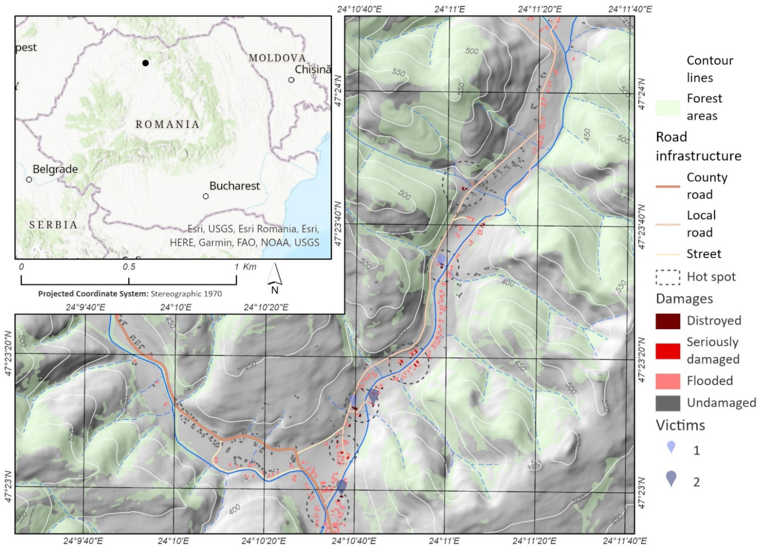
Figure 1. The geographic location of the study area.
Remotesensing 14 02481 g001
Figure 2. Methodological flowchart.
Remotesensing 14 02481 g002
Figure 3. The geographical position of GCP and CP.
Remotesensing 14 02481 g003
Figure 4. Cross-sectional profile used for the calculation of the maximum flow in the section.
Remotesensing 14 02481 g004
Figure 5. The water height corresponding to the floodable stripe.
Remotesensing 14 02481 g005
Figure 6. Shear Stress Map.
Remotesensing 14 02481 g006
Figure 7. Velocity Map.
Remotesensing 14 02481 g007
Figure 8. The cumulated effects of shear stress and velocity on the road infrastructure and buildings.
Remotesensing 14 02481 g008
Figure 9. Hazard and risk map for study area.
Remotesensing 14 02481 g009
Table 1. Database used in spatial analysis.
No.NameStructureTypeAttributes
1UAV photographsRaster/.jpgprimary
2GCPVector/pointprimaryXYZ coordinates
3CPVector/pointprimaryXYZ coordinates
4Dense Points CloudVector/pointmodeledRGB, XYZ
5DSMRaster/tifmodeledZ
6OrthomosaicRaster/tifmodeled-
7Maximum flowNumericalcalculatedm3/s
8Cross-sectional profilesVectorprimary-
9Riverbed banksVector/lineprimary-
10ThalwegVector/lineprimary-
11The Manning coefficientNumericalcalculated-
12SlopeNumericalcalculated-
13Water surface elevationRaster/tifmodeledm
14Shear stressRaster/tifmodeledPa/m2/s
15VelocityRaster/tifmodeledm/s
16Floodable stripeVector/linemodeledsurface
17BuildingsVectorprimarycost EUR/m2
18Risk areaRaster/tifmodeled-
Table 2. The hazard classes used for risk assessment.
HazardWater Depth (m)Shear Stress
(Pa/s/m2)
Explanations
Small<0.5 m>13.74Water depth does not induce significant damages, the drowning hazard is low and the evacuation of people can be made on foot. The water pressure on the residential infrastructures is medium, causing a risk of collapse in buildings with a poor structural frame.
Medium0.5–1 mWater depth generates damages, and there is a drowning hazard, especially for children and elderly people. Evacuation can be made by traditional means of response. The water pressure on the buildings is medium, inducing the collapse risk on the buildings with a poor structural frame.
Large1–2 mWater depth may induce significant damages, the drowning hazard is high for children and adults. Evacuation is conducted with difficulty. The water pressure on the buildings is medium, causing a risk of collapse in buildings.
Very large>2 mWater depth exceeds the average height of a room, and the risk of drowning is imminent. Evacuation cannot be conducted by classical means of response. The evacuation time decreases proportionally with the water depth, and the water pressure on the buildings is medium, causing a risk of collapse in the buildings.
Table 3. Hazard-based risk identification.
HazardConsequencesExposure
Low
(<EUR 2000)
Medium
(EUR 2000–6000)
High
(EUR 6000–12,000)
Very High
(>EUR 12,000)
Very Large Buildings
Large
Medium
Small
Low RiskRequires information and awareness sessions
Medium RiskRequires development of limiting land use planning projects for buildings in floodable areas
High RiskRequires immediate measures, the development of local risk reduction strategies
Publisher’s Note: MDPI stays neutral with regard to jurisdictional claims in published maps and institutional affiliations.