Abstract
Open access airborne laser scanning (ALS) data have been available in Finland for over a decade and have been actively applied by the Finnish archaeologists in that time. The low resolution of this laser scanning 2008–2019 dataset (0.5 points/m2), however, has hindered its usability for archaeological prospection. In the summer of 2020, the situation changed markedly, when the Finnish National Land Survey started a new countrywide ALS survey with a higher resolution of 5 points/m2. In this paper we present the first results of applying this newly available ALS material for archaeological studies. Finnish LIDARK consortium has initiated the development of semi-automated approaches for visualizing, detecting, and analyzing archaeological features with this new dataset. Our first case studies are situated in the Alpine tundra environment of Sápmi in northern Finland, and the assessed archaeological features range from prehistoric sites to indigenous Sámi reindeer herding features and Second Word War-era German military structures. Already the initial analyses of the new ALS-5p data show their huge potential for locating, mapping, and assessing archaeological material. These results also suggest an imminent burst in the number of known archaeological sites, especially in the poorly accessible and little studied northern wilderness areas, when more data become available.
1. Introduction
Finland is the most forested of all the Nordic countries, with nearly 80 percent forest cover [1]. Owing to this, the use of aerial and satellite remote sensing, for example for detecting crop marks, has been of limited use in the country, as less than 10 percent of the whole country is covered by agricultural land. Thus, as soon as airborne laser scanning (ALS/LiDAR, light detection and ranging) data became available in 2009 from the Finnish National Land Survey (NLS), they were also eagerly adopted by Finnish archaeologists. ALS data and methods in Finland originated from the needs of forestry research and industry, e.g., [2], but the development of archaeological approaches was initiated immediately by the researchers from the University of Helsinki and the Finnish Heritage Agency (FHA) [3,4,5].
Since 2009, the open access NLS airborne laser scanning 2008–2019 dataset (henceforth ALS-0.5p) [6] has gained a permanent place in the Finnish archaeologist toolbox and is routinely used, for instance, for planning surveys [1]. However, the low resolution of the ALS-0.5p data, 0.5 points/m2, has dictated what kind of archaeological features can be surveyed with it. It has proven useful for locating various kinds of pit and mound features down to 2–5-m diameter, depending on the local conditions, such as Stone Age house pits, prehistoric pitfall traps, charcoal kilns, and modern conflict archaeological structures such as trenches and dugouts [7,8,9,10,11,12]. However, owing to its low-resolution, the ground-truthing of ALS observations has shown that numerous small-scale features had gone unnoticed, and the material was most useful for directing fieldwork to new areas, e.g., [5,7]. However, the open access ALS data have encouraged many archaeology enthusiasts to explore them actively as a hobby, and hundreds of new sites have been reported to heritage authorities as a result of this citizen–science engagement and co-operation [1,9,13,14].
In the summer of 2020 the situation changed strikingly, when the NLS launched a new countrywide ALS survey for a higher resolution elevation model with 5 points/m2. In this paper we present the first results of applying this newly available airborne laser scanning 5p (henceforth ALS-5p) material in archaeological studies. This research is part of a wider LIDARK consortium project coordinated by the FHA in association with the University of Oulu and funded by the Ministry of Agriculture and Forestry [15]. LIDARK project was launched in March 2021 and aims at developing semi-automated approaches for visualizing, detecting, and analyzing archaeological features with the ALS-5p dataset [10,16]. Because ALS-0.5p data have been openly available for over 10 years, no archaeological ALS missions were flown in Finland until 2019 when very high-resolution unmanned aerial vehicle (UAV) ALS surveys from drones were initiated [1].
Here we discuss the archaeological applications of the new ALS-5p dataset from the perspective of: (1) locating archaeological features based on both visual analyses and semi-automated detection using machine learning; (2) locational accuracy of the features; and (3) extraction of feature attribute information based on the DEMs derived from the ALS-5p point clouds. Point clouds from the first ALS-5p production areas were processed and quality checked by the NLS towards the end of 2020, and we received access to them early in 2021. By 2025, most of the country should be scanned with the higher resolution (northernmost parts by 2031) (Figure 1). The presented case study is situated in northern Finland in the Alpine tundra landscape of Eanodat, in Sápmi, the homeland of Europe’s only indigenous people Sámi (thus Northern Sámi (SáN) placenames are used throughout) (Figure 1). We discuss various types of archaeological localities, mostly with different-sized pit features with shallow embankments surrounding them, that range from Stone Age pitfall traps to historical-era indigenous Sámi reindeer herding sites and Second Word War-era German military structures. In the future, as new data become available from the NLS, the analyses will be continually expanded over large areas, eventually covering thousands of square kilometers, and the used methods will be continuously developed and refined accordingly.
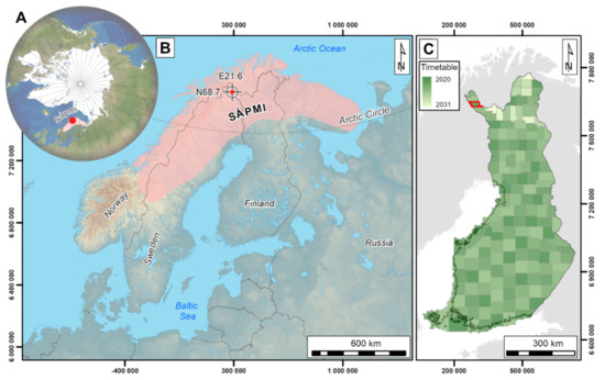
Figure 1.
(A,B) Location of the Ropijärvenperä production area in Sápmi (Finnish Lapland), northernmost Europe (highlighted with a red dot) (Background © Esri). (C) Finnish National Land Survey timetable for ALS-5p data collection, Ropijärvenperä with a red outline (EPSG:3879 ETRS89/GK25FIN). (Illustration: Oula Seitsonen).
2. Archaeological and Remote Sensing Materials and Methods
Our research material consists of the ALS-5p point clouds scanned in the summer of 2020 by the NLS in the about 1000 km2 Ropijärvenperä production area situated in Sápmi, northernmost Finland [17,18], and the archaeological data known from that area [14,19]. In this paper we discuss the results of the analyses of eight case study areas altogether covering 21 km2 (Figure 2: 1–8, Table 1). Below we describe first the archaeological material and the study area, the characteristics of the Ropijärvenperä ALS-5p dataset, and then the methods used for different analyses.
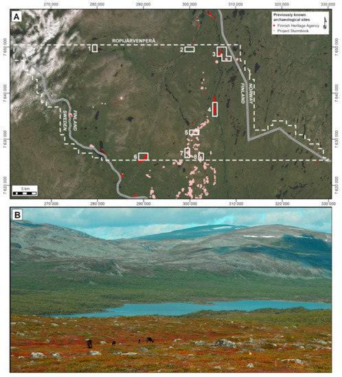
Figure 2.
(A) Ropijärvenperä production area, case study areas 1–8, and the previously known archaeological features in the area (Finnish Heritage Agency: red, N = 462; Project Sturmbock: pink, N = 1983). (Background © Esri, Maxar, GeoEye, Earthstar Geographics, CNES/Airbus DS, USDA, USGS, AeroGRID, IGN, and the GIS User Community; EPSG:3879 ETRS89/GK25FIN). (B) Typical landscape in the area, with open Alpine tundra up on the fjelds and mountain birch brush covering the valleys, notice the grazing reindeer on the foreground. (Illustration and photograph: Oula Seitsonen).

Table 1.
Case study areas 1–8 and the used ALS-5p tiles [17] and orthophotos [20].
2.1. Archaeological Material and the Ropijärvenperä Production Area
Case study areas 1 and 3–8 were selected based on the presence of previously ground-truthed archaeological features that provide reference material for the ALS-5p analyses, and the case study area 2 based on observation of previously unknown archaeological traces during a cursory visual inspection of the area. These initial analyses cover mere 2 percent of this vast and little studied wilderness region and will be expanded in the upcoming studies to cover the whole area and beyond (Figure 1). Only one previous archaeological survey has been carried out in this mostly roadless landscape by the Finnish National Board of Forestry (NBF) [19]. The NBF and FHA have registered altogether 462 archaeological features from the Ropijärvenperä production area, mostly trapping pits used for hunting wild reindeer along their seasonal migration routes in the past (Table 2).

Table 2.
Archaeological sites registered from the Ropijärvenperä production area by January 2021 (FHA = Finnish Heritage agency; PS = Project Sturmbock).
Nowadays the area is mostly used by Sámi pastoralists as seasonal herding grounds for their semi-domesticated reindeer. However, 75 years ago there was an intensive and unparalleled burst of human activity in this area that left a marked archaeological signature in the landscape. During the Second World War Finland had joined forces with Nazi Germany in the fight against the Soviet Union, and in 1944–1945 Germans built in this area a major defensive line consisting of Sturmbock-Stellung and Eisbär-Stellung, which stretched across the “western arm” of Finland from the Swedish border to Norway that was occupied by the Germans [12,14]. There were thousands of German soldiers and Prisoners-of-War involved in the construction work and stationed along the line in the otherwise extremely thinly inhabited wilderness. During their retreat to Norway in the winter of 1944–1945, the German troops destroyed their military installations and most of northern Finland’s civilian infrastructure using scorched earth tactics. Thus, most Second World War sites are preserved in an inconspicuous, more or less flattened state [21].
In 2018–2020 a devoted war history enthusiast-driven Project Sturmbock mapped the extent of German military structures along this defensive line, guided by the ALS-0.5p data [9,12]. The project published the results of their survey work as an open access online map in 2021 [14]. This is an impressive example where the devoted history enthusiasts’ activities have produced most of the known (conflict) archaeological data from the area. Altogether, the voluntary fieldworkers of the Project Sturmbock mapped nearly 2000 individual Second World War structures within the Ropijärvenperä production area (Table 2). In the future a closer co-operation between enthusiastic history and archaeology hobbyists and cultural heritage professionals could offer a beneficial way forward, for instance, combined with an online platform for visualizing and analyzing the high-resolution ALS data (see below).
The most common archaeological feature types with visible structures in the area are illustrated in Figure 3. These range from Prehistoric trapping pit systems to Sámi turf hut (SáN: dárfegoahti) remains and Second World War structures. Pitfall traps (Figure 3A) are usually less than 4.5 m in diameter, are encircled by a shallow embankment (10–30 cm) and can appear in kilometers-long continuous rows in the landscape [19]. Sámi turf hut floors (Figure 3B) date from the historical period (analogous structures are still used for temporal habitation by the reindeer herders) and are typically about 5–6 m in diameter, dug a little into the ground, and with a shallow hearth mound in the middle and shallow embankments (<20 cm). In this area they appear either as solitary features or in groups of over six hut floors. German Second World War structures (Figure 3C) are diverse and abundant in the landscape. These range from small foxholes and rubbish pits (diam. < 1 m), to collapsed or burned dugouts and tent places dug into the ground, to trenches and interconnected shooting positions [9].
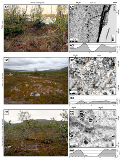
Figure 3.
Examples of the archaeological feature types encountered in the study area, in terrain photographs and ALS-5p DEM visualizations (SVF+multi-HS), with feature sections derived from the DEMs [17]. (A1–A3) Pitfall traps. (B1–B3) Sámi turf hut floor. (C1–C3) German Second World War outpost with tent placements, dugouts, rubbish pits, foxholes, and a latrine on the right. (EPSG:3879 ETRS89/GK25FIN). (Illustration and photographs (B1–C1): Oula Seitsonen, photograph (A1): Sami Viljanmaa).
The Ropijärvenperä production area is mostly open Alpine tundra landscape, with shallow mountain birch thickets growing in the valleys between the fjelds (Figure 1, Figure 2, Figure 3 and Figure 4). However, this open landscape is often covered by knee-high or lower dwarf birch, willow, and heather shrub, that often effectively hides the archaeological features. Alongside the ALS analyses, we assessed the visibility of the features in the NLS natural color (red-green-blue) and color-infrared orthophotos (NIR-Red-Green) with 0.5-m resolution [20] ([22] for northern Norway). In Figure 5, a small, remote German Second World War military outpost situated at Hirvasvuohppi on the Norwegian border (case study area 3) is illustrated as an example of the different datasets. As one can see from Figure 5A,B, the shallow trenches and tent placements (depth <50 cm) are visible in both ALS visualizations, while the northern trench and some of the water-filled tent foundations are also discernible in the orthophotos (Figure 5C,D). This shows how also the 1-m resolution DEM, derived from the ALS-0.5p data, provides a decent starting point for planning and directing archaeological field studies. However, the ALS-5p visualization (Figure 5B) is clearly superior in detail and shows even the tent entrances and some pathways used by the soldiers as shallow hollow-ways. Detailed ALS-5p data allow, for instance, drawing sketch maps of the sites based on the DEMs already before going in the field, and the measurement of various attributes of individual structures with high accuracy, such as their size, depth, and sections (Figure 3, see below).
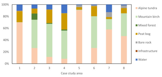
Figure 4.
Landcover in each case study area (based on Corine Landcover data, NLS, CC-BY-4.0). (Illustration: Oula Seitsonen).
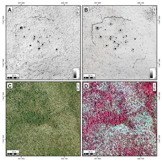
Figure 5.
The remote sensing datasets used in the analyses: a remote German military outpost at Hirvasvuohppi visualized with (A) ALS-0.5p (1-m DEM, visualized with SVF+Multi-HS). (B) ALS-5p (0.2-m DEM, SVF+Multi-HS) [17]. (C) Natural color orthophoto. (D) Color-infrared orthophoto. (NLS, CC-BY-4.0; EPSG:3879 ETRS89/GK25FIN). (Illustration: Oula Seitsonen).
2.2. Characteristics and Visulization of the Ropijärvenperä ALS-5p Data
At the moment, the new ALS-5p material is not available as open access data but a user-license can be obtained from the NLS with a nominal fee [18]. Point clouds are distributed in laz-format as 1 km2 tiles. In the future, these point clouds will be made openly accessible through the NLS website with a downgraded 0.5 points/m2 resolution. Ropijärvenperä production area was scanned in the early summer of 2020 with two scanning flights. Technical characteristics of the scanning and the produced point clouds are summarized in the Table 3 as reported by the NLS. These vary in detail from one production area to other depending on the contractor deployed by the NLS, but the produced datasets are comparable for instance in their vertical and horizontal accuracy [16,17,18]. All ALS-5p dataset are quality checked by the NLS before distribution and will eventually form the basis for a nationwide elevation model.

Table 3.
Technical characteristic of the Ropijärvenperä production area ALS-5p data [17].
Our ALS point cloud processing pipeline is going through constant development and testing, and, therefore, we will not describe it here in detail. After assessing various setups and resolutions, at the moment we have settled on using LAStools® [23] for producing 0.2-m resolution bare-earth digital elevation models (DEMs) based on empirical testing with our archaeological material [24]. Ground points in the data have a class value 2, according to LAS 1.2 format, and represent the lowest surface scanned from the air. Visualization of the DEMs was carried out with the Relief Visualization Toolbox 2.2.1® (RVT) [25,26]. Especially the sky-view-factor visualizations (SVF) [25], local relief models (LRM) [27], and analytical hill shading from multiple directions (Multi-HS) [25,28], various combinations of these, and their blended mixtures [26], have proven as useful starting points for both visual and semi-automated assessment of the data (see below).
2.3. Semi-Automated Feature Detection from the ALS-5p Data
Visual analysis is always subjective and dependent on, for instance, the experience of the observer [22]. Therefore, we are also testing different semi-automated feature detection methods based on machine learning (ML) and deep learning (DL) approaches to computer vision with the ALS-5p data [29]. In our initial analyses, we have applied a U-Net-based convolutional neural network (CNN) [30] through the Picterra® online platform [31]. CNNs can, among other things, outline predefined objects from raster images based on their pixel relation patterns, which do not need to be identical, but share similar general representation [29]. Thus, they offer a potential approach for detecting roughly corresponding archaeological features, such as pitfall traps, house pits, mounds, and other structures that share analogous general attributes [32,33,34,35,36]. Our initial assessment was based on the footprints of archaeological features in various DEM derivatives. Besides Picterra, we have also started experimenting with the lunar LiDAR CNN approach, originally developed for crater detection and recently successfully adapted to archaeological prospection [32], as well as with the “Simple Faster R-CNN” (Region-based CNN) approach [36]. In the future we also plan to examine using, for instance, Kohonen’s self-organizing maps (SOMs) and hierarchical clustering (HAC) for detection and classification based on multivariate morphometric characteristics of features. This approach has been shown by de Matos-Machado and others [24] to be very effective at least with the 20th century conflict archaeological material.
Picterra provides a user-friendly and rapid interface for defining the training data and carrying out analyses with automated preprocessing and postprocessing steps, and an effective cloud-based distributed computing [31]. It separates the outcomes of the U-Net model’s per pixel classification into separate objects and outputs Mask R-CNN-like object instance segmentation results [29,36,37]. The detected objects and their centroids are downloadable for further analyses for instance in GIS software. Different DEM derivatives were tested for training and detecting purposes (including SVF, anisotropic SVF, LRM, openness, multi-HS, and combinations of these). The best results when assessed against the previously known features were obtained with the SVF visualizations (with 16 search directions and a 15 pixel, i.e., 3-m, search radius). Training and accuracy testing features were selected from the case study areas with most known archaeological features of each type.
Previously known archaeological sites (see Figure 2 and Figure 3) were used for training three separate detectors for the initial analyses (Figure 6). Detector-1 (D1) targeted smaller, under 5-m diameter, roundish pit features, such as pitfalls and German Second World War foxholes or rubbish pits. Detector-2 (D2) was trained for locating larger, over 5-m diameter, more amorphous, shallow pits, such as Sámi turf hut floors and Second World War dugouts or tent placements. Detector-3 (D3) was aimed for locating linear features, namely German Second World War trenches. Since the training and development of the detection methods is ongoing, we do not assess the detectors quantitatively in this article. Here it suffices to summarize that all of them produced good results even with the initial analyses rounds. Both D1 and D2 worked nicely even with small, under 100 feature training datasets, and produced over 95 percent F-scores, although particularly D1 detected also numerous false positives, especially in the uneven boggy terrains common in the area (Figure 6). However, once we masked the bog and water areas, the accuracy of both detectors was significantly improved. D3 produced initially lowest F-scores, as besides trenches it detected small streams, roadside ditches, and interpolation artefacts in water areas, but with the masking of bogs and water and adding further training data, over 90 percent accuracy was reached.
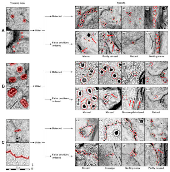
Figure 6.
Examples of the U-Net detector D1–3 training data and detection results (here based on SVF visualizations, examples from all case study areas). (A1–A10) Detector-1. Smaller (diam. < 5 m), roughly round pit features with shallow embankments, such as pitfalls, foxholes, and rubbish pits. (B1–B10) Detector-2. Larger (>5 m), more amorphous shallow pit features with shallow embankments, such as Sámi turf hut floors and German Second World War dugouts and tent places. (C1–C10) Detector-3. Linear features, namely German Second World War trenches. (Illustration: Oula Seitsonen).
2.4. Methods for Assessing Locational Accuracy of Archaeological Features
We have so far assessed the locational accuracy of features and feature attribute extraction (see below) using the trapping pit system in the Mohkkeguoika study area as a test case (Figure 3A and Figure 7C; case study area 4). This system was documented in the field by our colleague archaeologist Sami Viljanmaa in mid-June 2014, during the only archaeological survey of the area so far. He recorded the location of altogether 156 features in the study area with a basic handheld Garmin GNSS-unit (with about ±3-m accuracy). However, due to the remoteness of this locality (only reachable on foot or by boat) he did not have time to record feature-specific attribute data that are customarily collected in archaeological surveys in Finland. Instead, he offered a general overview of the pits describing them as being large, round or oval, usually surrounded by a shallow embankment, and at least four meters in diameter and 0.5–1.5 m in depth [19].
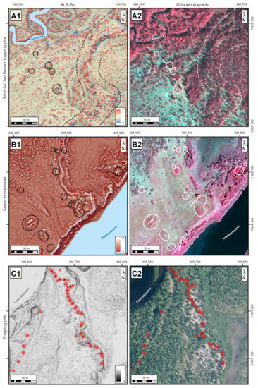
Figure 7.
Examples of features documented from the ALS-5p visualizations [17] and orthophotos [20]. (A1,A2) Previously unregistered Sámi turf hut foundations (circled) and previously known pitfalls (bordered with a dashed line) at Ádjajohka (area 6; ALS-5p: LRM+SVF+multi-HS). (B1,B2) A historical-era Finnish settler wilderness homestead with several turf hut foundations and other new features (circled) detected at Hirvasvuohppi (area 3; ALS-5p: Openness+multi-HS). (C1,C2) Part of a previously unregistered trapping system at Mohkkeguoika (area 4; highlighted in red as detected by the used U-Net Detector D1) (ALS-5p: SVF+multi-HS). (EPSG:3879 ETRS89/GK25FIN). (Illustration: Oula Seitsonen).
Below we describe the methods used to review the locational accuracy, shape, size, depth, and absolute elevation of the pits with the data extracted from the ALS-5p material. Specific feature locations can be extracted using several methods, for instance, by manipulating the original DEMs to improve their visual appearance, or to create output rasters and shapefiles for semi-automated data extraction. The visual method is very straightforward but time-consuming, as the midpoints of each feature are first approximated on the screen and then manually digitized. Semi-automated methods based on various algorithms speed up the process significantly, are independent of the observer, but are also potentially prone to systematic errors, such as false positives (for example, with summertime snowbanks, see Figure 6).
To explore the issue of potential caveats in positioning, a comparative experiment was carried out with the Mohkkeguoika pitfall traps. This was based on four different types of positioning data, where the centroids of archaeological features were determined independently: (1) with a handheld Garmin GNSS-receiver; (2) approximated on-screen by one of the authors; (3) calculated from DEM derivatives using ArcMap 10.7.1®; and (4) determined from the shapefiles from the CNN analyses (see below). GPS-data were extracted from Viljanmaa’s survey report. The manual digitalization of pit centroids was based on a combination of two visualizations produced with RVT software package, by projecting a 40 percent transparent hill shading from multiple directions (16 directions with 35 sun elevation angle) over a sky-view factor visualization. In ArcMap the centroids of pits were extracted from DEM as follows. First, sinks in the terrain were evened out from the 0.2 × 0.2-m DEM with a fill-tool. The original DEM was then subtracted from this raster, and the resulting new raster cleared of shallow anomalies by reclassifying it into two categories. The remaining raster features were turned into polygons and subsequently to points by determining their centroids. This last stage of spatial analysis was replied with the polygons and centroids based on the CNN detector D1 as downloaded from Picterra. The manually digitized pit locations from DEM visualization were used as a baseline to which the other positioning datasets were compared (see below).
2.5. Methods for Querying Attributes of Archaeological Features
We also assessed the potential of querying features attributes with the trapping pits in Mohkkeguoika area. Attribute data, which was not collected during the fieldwork due to restrictions in time and field conditions, was extracted as a test case based on the ALS-5p data (see Figure 3). This included determining the absolute elevation above sea level, depth, and diameter of the pits. Regarding the absolute elevation, one must decide whether it is determined from the bottom of the pit using the original DEM, or if a projected “original” ground surface elevation obtained by filtering the raster is preferable. We applied the latter approach.
As for the other attributes, the depth of each pit was calculated as the difference in elevation between the raster from which sinks had been smoothed away, and the original DEM at a feature centroid. The diameter for each pit was extracted from the surface area of the feature. This was accomplished using the ArcMap Cut Fill-filter, which calculates changes both in area and volume for the compared raster files, and then compared with the manually digitized polygons and those defined by the CNN detector D1 as downloaded from Picterra.
3. Discussion
In the following we discuss the results from our initial case studies from three main perspectives: (1) locating of archaeological features based on both visual and semi-automated analyses; (2) locational accuracy of the features; and (3) extraction of feature attribute information based on the DEMs derived from the ALS-5p point clouds. These are among the main questions that we target when developing the new archaeological approaches for the ALS-5p data in the LIDARK project.
3.1. Locating Archaeological Features
Since our initial case study covers only 21 km2, we were able to visually survey the different visualizations of ALS-5p-derived DEMs relatively rapidly from the whole region. We used the features mapped during this process as a baseline to which we compared the previously recorded archaeological features and the results from the U-Net object instance segmentation (including locating false positives; see Figure 6). The visibility of the new observations and known archaeological sites in the orthophotographs was also assessed during this process.
Altogether, over 1000 new archaeological features were observed from the ALS-5p visualizations, which doubles the number of known structures within the eight case study areas (Table 4). This is a mean rise of over 50 new features/km2, ranging from 16 to over 150 new features/km2. It must be remembered that the new observations have not been yet ground-truthed, as the analyses have just started, and the study area is under a thick snow-cover until late-June. However, many of these are so clear that they can be considered as traces of human activity with substantial confidence, as can be seen in Figure 6 and Figure 7. Vast majority of these new observations are various kinds of Second World War structures (N = 683; in areas 3, 5 and 7–8), followed by pitfall traps (N = 366; in areas 2–4 and 6). Of other new sites, one of the most interesting is a seasonal Sámi reindeer herder campsite at Ádjajohka (area 6), with at least six previously unregistered turf hut floors (Figure 7A). New features were detected also at and around all the known sites, such as the historical-era settler wilderness homestead at Hirvasvuohppi, with 15 previously recorded features and nine new ones (Figure 7B).

Table 4.
Number of archaeological features in each case study area before and after the exploratory analysis of ALS-5p data (numbers of the previously registered sites based on the Finnish Heritage Agency (FHA) and the Project Sturmbock (PS) data; “Other sites” are Stone Age and Iron Age habitation and find localities), and the percentage of total features that are visible in the orthophotos (both natural and false-color), and the percentage of how many were detected by the used U-Net detectors D1–3.
The visibility of features on orthophotographs is understandably highly dependent on the vegetation cover. In the study area 1 with 70 percent open tundra landcover, nearly 50 percent of the archaeological features are observable in the orthophotos. However, especially the pitfalls and other smaller pit features in bushier landscapes (Figure 7C) have a very limited visibility in the orthophotographs compared to the ALS visualizations. Limitations for the use of orthophotos is even more pronounced in other parts of Finland, where over 80 percent of the landscape is covered by coniferous and broad-leaved taiga forest [1,3,4,5,7,8].
Thuestad and others [22] have noted on the Norwegian side of Sápmi that multispectral images, especially including the near infrared (NIR) bands, appear promising for locating settlement sites with turf hut foundations. Even centuries-old habitation has enhanced the underlying soils which impacts the vegetation cover and composition, e.g., [38,39]. As suggested by Figure 7A,B, this is visible also in this region, at least at historical-era habitation sites where the vegetation has been affected by the recurring human and domestic animal, namely reindeer, activity [40,41]. This is apparent at both Sámi reindeer herder and Finnish settler sites, which are observable as more open habitation “fields” (SáN: “gieddi”, Finnish: “kenttä”) with more graminoids and less shrub. The turf hut foundations appear also highlighted as areas with more enhanced vegetation (Figure 7A,B). However, as seen with the Sámi site (Figure 7A1,A2), as soon as even scattered mountain birch shrub is present, the hut foundations can be completely obscured by it, as only one of the features detected from the ALS data is discernible in the orthophotograph.
As mentioned, in the CNN detection both the boggy terrains and water areas produced initially a large number of false positives, but masking these enhanced the detection results considerably. In Figure 8 the detection results are illustrated for the same German wilderness outpost as in Figure 5. In this case, the detectors D1–3 detected practically all the features recorded during the field surveys (N = 59), and on top of that also some small pit features that the surveyors had missed in the bushy landscape (N = 29; diameter < 1.5 m) and missed only 12 very small pit features that had been mapped in the field (diameter < 1 m). In all the case study areas, the detectors located well over 90 percent of the sites located with the visual analysis, ranging from 94 to 99 percent (Table 4). Since our detection methods are under constant development, the results will likely get better over time. Naturally, all the detection results need to be assessed at first on screen, for example to remove obvious false positives (see Figure 6), and eventually also in the field. Developing the approaches based on CNN detectors further seems like a potential and very productive way forward for detecting large expanses [32,33,34,35,36], such as the vast, roadless wilderness areas of Sápmi. Our initial experiments with lunar LiDAR approaches [32] have also proven very promising for locating various kinds of pit features from the ALS-5p data.
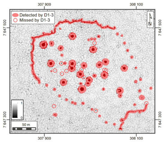
Figure 8.
The feature detection results from the CNN detectors D1–3 (highlighted in red) and twelve small (diam. < 1 m) pit features documented in the field but missed by the detectors D1–3 (circled with red) at the German Second World War wilderness outpost at Hirvasvuohppi (see Figure 3). (EPSG:3879 ETRS89/GK25FIN). (Illustration: Oula Seitsonen).
One notable remark to be considered when scanning or analyzing ALS material in northern regions, is the timing of flight campaigns. In many parts of Sápmi, snow can linger very long, until June–July, and sometimes throughout the summer especially in shady hollows. Scanning flights in the Ropijärvenperä area were flown in late-June when there was still considerable snow cover in 2020 in several places at the high altitudes. This is observable for example in the study area 5, where several sites recorded during the field surveys are completely invisible in the ALS data owing to the snow cover, and on the other hand, the semi-automated detection interpreted some of the melting snow features falsely as potential archaeological structures (Figure 9, also Figure 6).
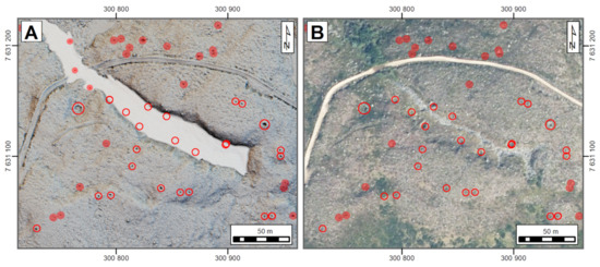
Figure 9.
Example of the effects of the snow cover: the archaeological features recorded in the field are shown with open red circles, and the new features detected by the CNN detector D1 are highlighted in red. (A) ALS-5p data scanned in late-June 2020, extent of snow cover highlighted with white, note the three false positives detected by D1 within the melting snowfield in the upper left corner, and the features covered by snow (SVF+Multi-HS) [17]. (B) Same location in late summer aerial imagery [20], the false positives in snow removed. (EPSG:3879 ETRS89/GK25FIN). (Illustration: Oula Seitsonen).
3.2. Locational Accuracy of Archaeological Features
It must be pointed out that the reasons for gathering attribute data in archaeological surveying have traditionally been twofold. Both descriptive and numeric data have been primarily collected to ease the identification of specific features for those who might be interested to locate them again. These kinds of data were especially important in the time before handheld GNSS-units became available. Back then the approximate location of a site or a feature was estimated and marked on 1:20 000 NLS topographic maps in the field, by combining informed observations of local terrain with any distinguishable features marked on the map itself. Even earlier, in the early-1900s before reliable maps became available for the whole country, the directions to the sites were given as estimated distances and compass directions to the local parish church. Today the situation is vastly improved, as for example the reported mean standard error in planimetric accuracy of the ALS-5p point cloud in the Ropijärvenperä production area is 0.039 m (Table 3) [17]. This is more than enough for archaeological survey purposes and for drawing sketch maps of the sites before going in the field.
When assessing the locational accuracy of the Mohkkeguoika trapping pits with the different approaches, the most apparent observation to be made is the inferiority of the data reported based on the measurements with the handheld Garmin-unit, compared to the methods based on the ALS-5p data (Table 5, Figure 10). Between the latter, the centroids calculated with ArcMap are slightly closer to the manually digitized ones than those obtained with Picterra U-Net model. The reasons for this are obvious: the used ArcMap algorithm emphasizes the depth of a feature, while pattern recognition in Picterra is geared more towards the horizontal footprint of the feature. Yet, the spatial data obtained through Picterra are well-suited for feature identification even when such features occur in tight clusters or rows, where the distance between individual features is limited (Figure 3A, Figure 6A and Figure 7C). The points gathered with the Garmin GNSS-unit, on the other hand, customarily land outside the features as observed in the ALS-5p visualizations. This increases the probability of swaps between feature points, and if other attribute data (see below) are collected alongside the positioning data, the probability of future misidentifications and errors is significantly increased.

Table 5.
Comparison of the trapping pit positioning data digitized manually from the ALS-5p visualizations with the data gathered using three observer independent methods (units in meters).
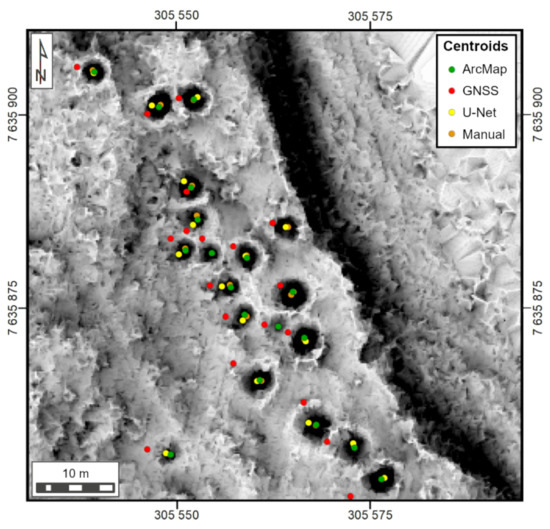
Figure 10.
Example of the comparison between the manually digitized positioning data for pitfall traps at Mohkkeguoika and the centroids acquired using the three observer independent methods (SVF visualization). (EPSG:3879 ETRS89/GK25FIN). (Illustration: Janne Ikäheimo).
3.3. Querying Attributes of Archaeological Features
We assessed the absolute elevation above sea level, depth, and diameter of the Mohkkeguoika trapping pits with the methods described above. The absolute elevation of pits ranges from 430 to 446 m above sea level. This seemingly large elevation variation is explained by the local topography, where a westward extension of the system counts for all the features situated above 440 m a.s.l., otherwise the trapping system runs along the relatively even banks of the River Leahttáseatnu (Figure 3A and Figure 7C). The depth of the examined pits ranges from 0.16 to 1.03 m. The average is 0.44 m with the standard deviation being just 0.19 m, which is much less than what Viljanmaa estimated in the field (0.5–1.5 m). Yet, the depth is the dimension of pit features that is most difficult to estimate reliably in the field and tends to get systematically overestimated in the survey reports, especially when an embankment surrounds a pit (see Figure 3A).
Concerning the diameter of the pit, through comparative experiments, it was found out that the used ArcMap filter yielded more reliable diameter data, than either the area polygons produced by Picterra’s U-Net model or the manually digitized polygons. The former data systematically overestimate the diameter, while it is easily underestimated in the latter. A credible value for the diameter, from 1.26 to 4.36 m, was achieved in 96 percent of the test cases. The outliers were overestimations caused by shallow pits without clearly definable edges that the algorithm tends to expand horizontally. In one case also two adjacent pits had been counted as one, and in a most extreme case, the pit “flooded” into the surrounding natural depression that was large enough to produce a staggering diameter estimate of 20.25 m. Thus, the reason for each anomalous value must be verified and adjusted accordingly. Moreover, while these results are not in line with surveyor’s generalization about the diameter—“at least four meters” [19]—several manually executed double-checks confirm the validity of the ALS-derived attribute data.
To conclude, the collection of feature attribute data, which has traditionally been the most time-consuming task of archaeological surveying, is possible to be carried out as a desktop assessment when the properties of the available ALS data allow this. The new ALS-5p data are well-suited for such task with its high locational accuracy, which will eventually affect the way that archaeological surveys of pit or mound features are carried out both in the office and out in the field. Because potential archaeological sites either composed of or containing pits and mounds will be now fairly easy to spot and locate with ALS-derived spatial data and adequately precise GNSS-units, the verification of their heritage status concerning the Finnish Antiquities Act [42] should be a guiding principle in the future field surveys. Attribute data are inevitably bound to lose their significance for heritage protection and management purposes, now used mainly for recognizing different features from one another, with the availability of exact positioning data. On the other hand, the research-use of attribute data will be enhanced and simplified by the ALS-5p data, and replicability of analyses improved. While much of the variation in such data can be attributed to post-depositional processes conditioned by factors like soil, local topography, and climate, we are positive that there are also human-induced patterns for the archaeologists to discover and interpret. In the future, as more ALS-5p data become available, in theory everyone can run and replicate the analyses of various attributes themselves. Producing easy to access and semi-automated platform and algorithms for this is again one of the main goals of the LIDARK project.
4. Conclusions
The availability of new high-resolution ALS-5p data opens a new period for Finnish archaeological surveys, heritage management and research. Their horizontal and vertical accuracy exceeds the currently available national elevation datasets by far and are in fact more precise than most archaeological field mapping data [16]. Of course, more precise location data can be acquired, for example, with total station, terrain laser scanning or precision-GNSS, but one can question what the benefit is of this increased accuracy for locating new sites or for drawing general maps.
The LIDARK project’s first analyses from the Ropijärvenperä production area in Sápmi illustrate well the applicability of this material for site and feature detection and locating, and for feature attribute extraction. These can be achieved using numerous approaches, from visual inspection and manual digitizing to various (semi-)automated feature and attribute extraction algorithms. LIDARK project aims eventually at developing approaches for gearing the latter, replicable methods. These would be accessible at least for the heritage professionals, and why not also for devoted archaeology and history enthusiasts who already now habitually use the low-resolution ALS-0.5p visualizations to locate new sites and report these to archaeologists [1,33]. One Finnish enthusiast, with an apt username MacGyver, has even developed his own highly operational and intuitive freeware program for the 3-dimensional visualization of DEMs and orthophotos [1,16,43]. Moreover, FHA opened in 2019 a very popular online Ilppari reporting portal for archaeological finds made by the public and over 10 000 finds have been reported through it since then. On 1 March 2021, FHA extended this to include a reporting service for archaeological sites and structures [44]. The productive field surveys by the enthusiast-driven Project Sturmbock in the Ropijärvenperä area are good examples of the strength of a citizen science approach [9,14].
Yet, while ALS-5p material will affect the way in which field surveys are planned and carried out in the future, one must always remember that ALS data and their analyses can never replace an inspection carried out by a field archaeologist. In the future, more time should be budgeted for the planning phase based on the ALS data, which would allow directing fieldwork and resources in an optimal way. In many cases it will also enable drawing general maps and sketches of potential sites before going in the field, as well as extracting feature attributes beforehand, such as diameter, depth, and absolute elevation above the sea level. Once the high-resolution data become available throughout the country, in theory all the interested people can do their own assessments and measurements of all the registered archaeological features from their own living room couch. Archaeological professionals should then concentrate in the field on ground-truthing the heritage nature of the potential observations based on the ALS material, and verifying and focusing the preliminarily extracted feature attribute data.
In the future, it will be important that the archaeologists studying and interpreting various features based on ALS material pay more attention and provide information on the systematic methods with which they acquire their data. This would allow the replicability and comparability of investigations carried out in different parts of the country by different actors, potentially also including enthusiastic members of the public. If access to the various analyses would be offered as a web service, with (semi-)automated algorithms for various purposes, this could ensure their uniformity. However, even if the ALS-5p data enrich the available information on archaeological sites, they do not always change the interpretational premises. For instance, in the Ropijärvenperä production area we knew already beforehand that there was an abundant number of Second World War features and trapping pits, but the new observations highlight the unknown extent and richness of these features even in the previously surveyed regions.
For Finnish heritage management the ALS-5p data are a vital step forward. For many sites, it is now for the first time becoming possible to define the exact location information for various features within the sites. This is vitally important for protection and preservation of sites, as at the moment there can be massive mistakes of hundreds of meters in the coordinate information of some of the sites. In fact, many of these have been completely lost through the years owing to these problems in the positioning data. Of course, updating the positioning information is only the first step, and the enhanced data need to be constantly distributed with the land-use planners and implementers. This necessitates also that these actors are up to date with the use and management of the data and have for instance adequate GNSS-units at their use.
As suggested by the near doubling of the known archaeological features in the case study area in our initial exploratory analyses, the wider utilization of ALS-5p data in the upcoming years will likely produce thousands of new sites and features that need to be checked in the field, e.g., [22]. One thing that needs to be taken into account in the future is that this development can easily skew the known and protected archaeological sites towards localities with features visible in the DEMs, at the expense of, for example, prehistoric habitation sites with few or no aboveground structures. It also remains to be seen, what this means for the heritage management, if the final frontiers devoid of archaeological sites will suddenly be teeming with potential features that need to be checked by archaeologists. Heritage management instances will need to find the resources and ways for inspecting these potential features and protecting the archaeological ones. One possible way forward could be offered by crowdsourcing and citizen science engagement [33,45,46] where archaeology and history enthusiasts could be trained to detect potential sites from the ALS datasets, and then to inspect, document, and report them to the authorities, for instance using a mobile application.
Author Contributions
Conceptualization, O.S.; formal analysis, O.S. and J.I.; investigation, O.S. and J.I.; methodology, O.S. and J.I.; validation, O.S. and J.I.; visualization, O.S. and J.I.; writing—original draft, O.S.; writing—review and editing, O.S. and J.I. Both authors have read and agreed to the published version of the manuscript.
Funding
This research was funded by European Research Council grant number 2017 756431, Finnish Academy grant number 308322, and Finnish Ministry of Agriculture and Forestry decision number VN/22710/2020-MMM-3.
Institutional Review Board Statement
Not applicable.
Informed Consent Statement
Not applicable.
Data Availability Statement
The used ALS-5p data are not open-access but the use-rights can be applied from the NLS for the price of 114,10 euros/production area [18]. Other used datasets are available open access from the Finnish Heritage Agency and the Finnish National Land Survey [6,19,20].
Acknowledgments
The authors wish to thank the anonymous reviewers for their insightful comments, reindeer master Juha Tornensis of the Giehtaruohttasa bálggus, Antti Ohenoja of the National Board of Forestry, and Sami Viljanmaa of the Kierikki Stone Age Center for local information, and Sámi Museum Siida, Sámediggi, Finnish National Board of Forestry, and the Finnish Heritage Agency for continued co-operation. This research is part of the LIDARK consortium and the University of Oulu Domestication in Action project. Open access funding provided by the University of Helsinki.
Conflicts of Interest
The authors declare no conflict of interest.
References
- Risbøl, O.; Langhammer, D.; Mauritsen, E.S.; Seitsonen, O. Employment, Utilization, and Development of Airborne Laser Scanning in Fenno-Scandinavian Archaeology–A Review. Remote Sens. 2020, 12, 1411. [Google Scholar] [CrossRef]
- Holopainen, M.; Haapanen, R.; Tuominen, S.; Viitala, R. Performance of Airborne Laser Scanning and Aerial Photograph-Based Statistical and Textural Features in Forest Variable Estimation. In Proceedings of the SilviLaser 2008, 8th International Conference on LiDAR Applications in Forest Assessment and Inventory, Heriot-Watt University, Edinburgh, UK, 17–19 September 2008; Hill, R.A., Rosette, J., Suárez, J., Eds.; Heriot-Watt University: Edinburgh, UK, 2008; pp. 105–112. [Google Scholar]
- Kurri, I.; Haimila, M. Metsää syvemmältä–Lidar-aineisto arkeologian apuvälineenä. Muinaistutkija 2010, 1, 63–67. [Google Scholar]
- Seitsonen, O. Juoksuhautoja ja asumuspainanteita: Kokemuksia Lidar-laserkeilausaineiston käytöstä kenttäarkeologiassa. Muinaistutkija 2011, 2, 36–46. [Google Scholar]
- Koivisto, S.; Laulumaa, V. Pistepilvessä–Metsien arkeologiset kohteet LiDAR-ilmalaserkeilausaineistoissa. Arkeolog 2012, 1, 51–67. [Google Scholar]
- Laser Scanning Data 2008–2019. Available online: https://www.maanmittauslaitos.fi/en/maps-and-spatial-data/expert-users/product-descriptions/laser-scanning-data (accessed on 17 July 2020).
- Seitsonen, O. LiDAR-kaukokartoitusaineistojen visualisointi ja analysointi: Paikkatietoalgoritmeja arkeologeille. Muinaistutkija 2013, 1, 2–16. [Google Scholar]
- Mustonen, R. Conquering the Forests with Lasers and Social Media—Finland’s National Forest Programme 2015 Cultural Heritage Survey. In Archaeological Sites in Forests: Strategies for their Protection; Irlinger, W., Suhr, G., Eds.; Volk: Munich, Germany, 2017; Volume 14, pp. 19–24. [Google Scholar]
- Sillanpää, E.; Rikkinen, A. Projekti Sturmbock. Loppuraportti; Survey Report; Project Sturmbock: Enontekiö, Finland, 2019. [Google Scholar]
- Ikäheimo, J. ”Vain muutaman pikselin tähden”: Varhaismetallikauden Pienipiirteiset Muinaisjäännökset Ilmalaserkeilausaineistoissa; Presentation at the National Museum of Finland, 4 February 2021. Available online: https://www.museovirasto.fi/fi/kulttuuriymparisto/kulttuuriymparistopalvelut-tehtavat-ja-yhteistyo/kulttuuriymparistopalveluiden-tilaisuudet-ja-tapahtumat/arkeologisten-kenttaetoiden-esittelypaivat (accessed on 10 February 2021).
- Seitsonen, O.; Moshenska, G. Who Owns the ‘Wilderness’? Indigenous Second World War Landscapes in Sápmi, Finnish Lapland. In Conflict Landscapes: Materiality and Meaning in Contested Places; Saunders, N.J., Cornish, P., Eds.; Routledge: Abingdon, UK, 2021. [Google Scholar]
- Stichelbaut, B.; Thomas, S.; Seitsonen, O.; Gheyle, W.; De Mulder, G.; Hemminki, V.; Plets, G. Operation Northern Light: Remote Sensing of a Second World War Conflict Landscape in Northern Finland. In Conflict Landscapes: Materiality and Meaning in Contested Places; Saunders, N.J., Cornish, P., Eds.; Routledge: Abingdon, UK, 2021. [Google Scholar]
- Mikkonen, K. Parakkeja ja Piikkilankaa; Lapin maakuntamuseo: Rovaniemi, Finland, 2016. [Google Scholar]
- Forgotten Fronts. Tutkimuksia Suomen Unohdetuilta Taistelukentiltä. Available online: https://www.forgottenfronts.fi/ (accessed on 7 January 2021).
- Hamari, P. Arkeologisten Kohteiden Automaattinen Tunnistaminen Laserkeilausdatasta–LIDARK; Research Plan; Museovirasto: Helsinki, Finland, 2020. [Google Scholar]
- Ikäheimo, J.; Seitsonen, O. Laserkeilausaineisto 5p arkeologisten kuoppajäännösten tutkimuksessa. Muinaistutkija. under review.
- MML 43562/05 00 00/2020. Ropijärvenperä. Use License and Metadata (Partly Confidential) to the Airborne Laser Scanning Data from the Ropijärvenperä Production Area. In Includes Finnish National Land Survey Laser Scanning 5p Data from the Year 2020; Finnish National Land Survey: Helsinki, Finland, 2020.
- Näin Hankit Laserkeilausaineistoja. Available online: https://www.maanmittauslaitos.fi/laserkeilausaineistot (accessed on 1 January 2021).
- Viljanmaa, S. Lätäsenon-Hietajoen Soidensuojelualue; Survey Report; Metsähallitus, Lapin Luontopalvelut: Rovaniemi, Finland, 2014. [Google Scholar]
- NLS Orthophotos. Available online: https://www.maanmittauslaitos.fi/en/maps-and-spatial-data/expert-users/product-descriptions/orthophotos (accessed on 16 October 2020).
- Seitsonen, O. Archaeologies of Hitler’s Arctic War. Heritage of the Second World War German Military Presence in Finnish Lapland; Routledge: Abingdon, UK, 2020. [Google Scholar]
- Thuestad, A.E.; Risbøl, O.; Kleppe, J.I.; Barlindhaug, S.; Myrvoll, E.R. Archaeological Surveying of Subarctic and Arctic Landscapes: Comparing the Performance of Airborne Laser Scanning and Remote Sensing Image Data. Sustainability 2021, 13, 1917. [Google Scholar] [CrossRef]
- Rapidlasso GmbH. Available online: https://rapidlasso.com/ (accessed on 10 February 2021).
- De Matos-Machado, R.; Toumazet, J.-P.; Bergès, J.-C.; Amat, J.-P.; Arnaud-Fassetta, G.; Bétard, F.; Bilodeau, C.; Hupy, J.P.; Jacquemot, S. War Landform Mapping and Classification on the Verdun Battlefield (France) Using Airborne LiDAR and Multivariate Analysis. Earth Surf. Process. Landf. 2019, 44, 1430–1448. [Google Scholar] [CrossRef]
- Zakšek, K.; Oštir, K.; Kokalj, Ž. Sky-View Factor as a Relief Visualization Technique. Remote Sens. 2011, 3, 398–415. [Google Scholar] [CrossRef]
- Kokalj, Ž.; Somrak, M. Why Not a Single Image? Combining Visualizations to Facilitate Fieldwork and On-Screen Mapping. Remote Sens. 2019, 11, 747. [Google Scholar] [CrossRef]
- Hesse, R. LiDAR-Derived Local Relief Models–a New Tool for Archaeological Prospection. Archaeol. Prospect. 2010, 17, 67–72. [Google Scholar] [CrossRef]
- Devereux, B.J.; Amable, G.S.; Crow, P. Visualisation of LiDAR Terrain Models for Archaeological Feature Detection. Antiquity 2008, 82, 470–479. [Google Scholar] [CrossRef]
- Garcia-Molsosa, A.; Orengo, H.A.; Lawrence, D.; Philip, G.; Hopper, K.; Petrie, C.A. Potential of Deep Learning Segmentation for the Extraction of Archaeological Features from Historical Map Series. Archaeol. Prospect. 2021, 1–13. [Google Scholar] [CrossRef]
- Ronneberger, O.; Fischer, P.; Brox, T. U-Net: Convolutional Networks for Biomedical Image Segmentation. In Medical Image Computing and Computer-Assisted Intervention–MICCAI 2015. Lecture Notes in Computer Science 9351; Navab, N., Hornegger, J., Wells, W., Frangi, A., Eds.; Springer: Cham, Switzerland, 2015. [Google Scholar]
- Picterra. Available online: https://picterra.ch/ (accessed on 7 January 2021).
- Gallwey, J.; Eyre, M.; Tonkins, M.; Coggan, J. Bringing Lunar LiDAR Back Down to Earth: Mapping Our Industrial Heritage Through Deep Transfer Learning. Remote Sens. 2019, 11, 1994. [Google Scholar] [CrossRef]
- Lambers, K.; Verschoof-van der Vaart, W.B.; Bourgeois, Q.P.J. Integrating Remote Sensing, Machine Learning, and Citizen Science in Dutch Archaeological Prospection. Remote Sens. 2019, 11, 794. [Google Scholar] [CrossRef]
- Trier, Ø.D.; Cowley, D.C.; Waldeland, A.U. Using Deep Neural Networks on Airborne Laser Scanning Data: Results from a Case Study of Semi-Automatic Mapping of Archaeological Topography on Arran, Scotland. Archeol. Prospect. 2019, 26, 165–175. [Google Scholar] [CrossRef]
- Verschoof-van der Vaart, W.B.; Lambers, K. Learning to Look at LiDAR: The Use of R-CNN in the Automated Detection of Archaeological Objects in LiDAR Data from the Netherlands. J. Comput. Appl. Archaeol. 2019, 2, 31–40. [Google Scholar] [CrossRef]
- Trier, Ø.D.; Rekstena, J.H.; Løseth, K. Automated Mapping of Cultural Heritage in Norway from Airborne Lidar Data Using Faster R-CNN. Int. J. Appl. Earth Obs. Geoinf. 2021, 95, 102241. [Google Scholar] [CrossRef]
- He, K.; Gkioxari, G.; Dollár, P.; Girshick, R.B. Mask R-CNN. In Proceedings of the 2017 IEEE International Conference on Computer Vision (ICCV), Venice, Italy, 22–29 October 2017; pp. 2980–2988. [Google Scholar]
- Fenger-Nielsen, R.; Hollesen, J.; Matthiesen, H.; Andersen, E.A.S.; Westergaard-Nielsen, A.; Harmsen, H.; Michelsen, A.; Elberling, B. Footprints from the Past: The Influence of Past Human Activities on Vegetation and Soil Across Five Archaeological Sites in Greenland. Sci. Total Environ. 2019, 654, 895–905. [Google Scholar] [CrossRef]
- Karlsson, N. Bosättning och Resursutnyttjande. Miljöarkeologiska Studier av Boplatser Med Härder Inom Perioden 600–1900 e. Kr Inom Skogssamiskt Område. Studia Archaeologica Universitatis Umensis 21; Umeå Universitet: Umeå, Sweden, 2006. [Google Scholar]
- Seitsonen, O.; Viljanmaa, S. Landscapes of Sámi Reindeer Domestication and Pastoralism in the Gilbbesjávri Region, Sápmi, Northernmost Europe ca. 700–1800 A.D. J. Field Archaeol. 2021, 46, 172–191. [Google Scholar] [CrossRef]
- Seitsonen, O.; Égüez, N. Here be Reindeer: Geoarchaeological Approaches to the Transspecies Lifeworlds of the Sámi Reindeer Herder Camps on the Tundra. Iskos 24. under review.
- 295/1963 English. Antiquities Act. Muinaismuistolaki. Lag om Fornminnen. Available online: https://www.finlex.fi/en/laki/kaannokset/1963/en19630295 (accessed on 1 April 2018).
- MacGyver. 3D Rinnevarjokartta. Available online: https://www.aarremaanalla.com/foorumi/viewtopic.php?f=10&t=23689 (accessed on 24 December 2020).
- Ilppari Reporting Service. Available online: https://www.kyppi.fi/palveluikkuna/ilmoitus/edit/asp/enk_default.aspx (accessed on 1 March 2021).
- Seitsonen, O. Crowdsourcing Cultural Heritage: Public Participation and Conflict Legacy in Finland. J. Community Archaeol. Herit. 2017, 4, 115–130. [Google Scholar] [CrossRef]
- Hassanzadeh, P.; Hyvönen, E.; Ikkala, E.; Tuominen, J.; Thomas, S.; Wessman, A.; Rohiola, V. FindSampo Platform for Reporting and Studying Archaeological Finds Using Citizen Science. In Workshop on Humanities in the Semantic Web; Adamou, A., Enrico Daga, E., Meroño-Peñuela, A., Eds.; CEUR-WS.org: Heraklion, Greece, 2020; pp. 33–40. Available online: http://ceur-ws.org/Vol-2695/paper4.pdf (accessed on 20 June 2020).
Publisher’s Note: MDPI stays neutral with regard to jurisdictional claims in published maps and institutional affiliations. |
© 2021 by the authors. Licensee MDPI, Basel, Switzerland. This article is an open access article distributed under the terms and conditions of the Creative Commons Attribution (CC BY) license (https://creativecommons.org/licenses/by/4.0/).