Abstract
The Qaidam Basin is a unique and complex ecosystem, wherein elevation gradients lead to high spatial heterogeneity in vegetation dynamics and responses to environmental factors. Based on the remote sensing data of Moderate Resolution Imaging Spectroradiometer (MODIS), Tropical Rainfall Measuring Mission (TRMM) and Global Land Data Assimilation System (GLDAS), we analyzed the spatiotemporal variations of vegetation dynamics and responses to precipitation, accumulative temperature (AT) and soil moisture (SM) in the Qaidam Basin from 2001 to 2016. Moreover, the contribution of those factors to vegetation dynamics at different altitudes was analyzed via an artificial neural network (ANN) model. The results indicated that the Normalized Difference Vegetation Index (NDVI) values in the growing season showed an overall upward trend, with an increased rate of 0.001/year. The values of NDVI in low-altitude areas were higher than that in high-altitude areas, and the peak values of NDVI appeared along the elevation gradient at 4400–4600 m. Thanks to the use of ANN, we were able to detect the relative contribution of various environmental factors; the relative contribution rate of AT to the NDVI dynamic was the most significant (35.17%) in the low-elevation region (<2900 m). In the mid-elevation area (2900–3900 m), precipitation contributed 44.76% of the NDVI dynamics. When the altitude was higher than 3900 m, the relative contribution rates of AT (39.50%) and SM (38.53%) had no significant difference but were significantly higher than that of precipitation (21.97%). The results highlight that the different environmental factors have various contributions to vegetation dynamics at different altitudes, which has important theoretical and practical significance for regulating ecological processes.
1. Introduction
Vegetation plays an important role in terrestrial ecosystems and is one of the critical indicators for evaluating ecological environmental systems [1]. The spatial distribution of vegetation is the result of climatic conditions and the long-term relative stability and fluctuation of human activities [2,3]. Temperature, precipitation, light and other climatic factors determine the grade, distribution and zonal variation law of vegetation, forming the general pattern of vegetation [4]. The vegetation spatial pattern changes reflect vegetation’s response to environmental conditions and human activities [5]. Vegetation dynamics are sensitive to environmental changes and have significant dynamic and evolutionary characteristics [6].
With the development of remote sensing technology and its application in ecosystem research, researchers have carried out space monitoring of the landcover change dynamics [7]. A large number of data were used to represent the pattern of landcover, especially the Normalized Difference Vegetation Index (NDVI). NDVI can describe biophysical characteristics such as vegetation growth status and vegetation dynamics [8] and is usually directly used to conduct research on global or regional vegetation classification and vegetation cover changes [5,9,10]. Based on the NDVI, Zhang et al. [6] studied the vegetation change of the Kosh River basin in the central Himalayas from 1982 to 2011, and the results indicated that vegetation cover showed different trends in different periods, which was mainly influenced by climate change. Reddy and Prasad [11] predicted the dynamic change process of vegetation based on NDVI data and the long short-term memory (LSTM) method and put forward a research method for predicting vegetation change, which is conducive to taking positive measures to protect and improve regional vegetation. Therefore, in this study, NDVI from 2001 to 2019 was selected as indicator of vegetation dynamics in the Qaidam Basin.
The variation in vegetation cover is mainly affected by changes in environmental factors. Many scholars have explored the effect of vegetation cover under the influence of human activities and climate change [12,13,14], such as the correlation between NDVI and meteorological factors via statistical methods [15,16]. However, most of these studies use linear correlation to reflect the interaction between vegetation cover and climatic factors, so it is difficult to describe the dynamic climate-ecosystem characteristics.
Some other studies focused on the relationship among different factors in soil–vegetation–atmosphere complex systems by establishing vegetation models. In the early stages, researchers proposed many models, such as the biogeographic model [17] and biophysical model [18]. Later, global vegetation dynamics models have emerged, such as the Integrated Biosphere Simulator (IBIS), Lund–Potsdam–Jena (LPJ) model [19] and spatially explicit individual-based (SEIB) model [20]. These models integrate the dynamic process of biophysical vegetation on a large scale, which makes up for the deficiency of earlier models and can effectively simulate and analyze the dynamic change process of terrestrial vegetation [21]. However, most of these models require extensive parameters and expensive data. Moreover, most models’ parameters are historically based and so it is hard to reflect the climate and other condition changes. Therefore, it is impossible to conduct quantitative calculations on the importance of influencing factors of vegetation cover evolution.
With the development of machine learning, the innovation of data analysis methods has been profoundly involved in traditional scientific research, providing new technologies for the development of basic science [22,23]. For example, Buckland [24] used artificial neural networks (ANN) to analyze the relationship between dust deposition and land use, wildfire and climatic conditions. Benliay [25] evaluated the relationship between vegetation change and climatic comfort factors by using an ANN model.
The Qaidam Basin is located in the north of the Qinghai-Tibet Plateau. It has an alpine area, arid climate, complex topography and low and concentrated human activities. It is an ideal region to study the relationship between vegetation and environmental factors in a natural state. The Qaidam Basin is also one of the most sensitive regions to global climate change due to the fragile ecological environment [26,27]. The vegetation dynamics in the basin can comprehensively reflect regional and even global climate and environmental changes. Although there are reports about the relationship between vegetation cover and climatic factors in the Qaidam Basin, most of them are only the correlation between vegetation index and a single meteorological factor via linear correlation statistics [28,29]. To quantitatively address the complex relationship of vegetation to surrounding environmental factors, we constructed an ANN model to identify the responses and contributions to the vegetation dynamics in the Qaidam Basin.
2. Material and Methods
2.1. Study Area
The Qaidam Basin is located in the northwest of China and bounded by the Aerjin Mountains, Qilian Mountains, and the Kunlun Mountains from the northwest, northeast, and south. It is the world’s only large inland plateau basin, covering an area of 281,000 km2, with elevations between 2653 and 6748 m above sea level, as shown in Figure 1.
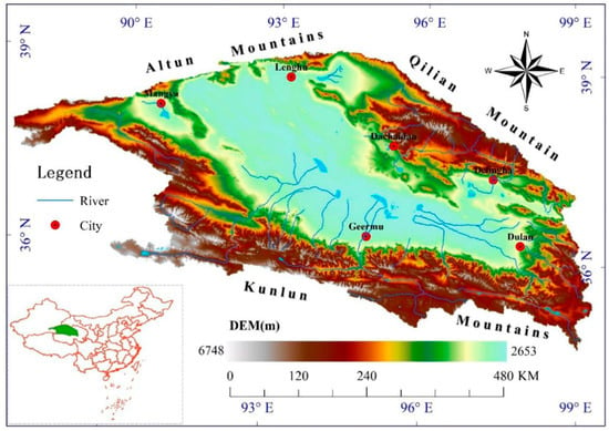
Figure 1.
The study area of the Qaidam Basin.
The Qaidam Basin is a typical alpine dry continental zone with precipitation of 13.9–564.2 mm and evaporation 1200–3500 mm. The average temperature is 4.6 °C, and the wind speed is 3.4 m/s. Inside the basin, the desert landscape dominates widely, including salt desert and sand desert. The vegetation coverage is low, mainly with the xeric and halophytic plant species, such as H. ammodendron, Artemisia desertorum, Phragmites australis, Ephedra sinica, Calligonum mongolicunl, Tamarix ramossissima Ledeb., Nitraria Schoberi L., and Achnatherum splendens [30]. The mountain areas of the basin are dominated by the meadow. In the piedmont plain, piedmont alluvial fan, alluvial fan, and surroundings of rivers and lakes, vegetation is usually luxuriant and plant species are relatively rich. The main land use types were grassland and unused land, accounting for 51.6% and 44.9% of the basin, respectively [31]. The region is characterized by scarce precipitation, high desertification and cold temperature. It is a highly fragile ecological environment region.
2.2. Data
2.2.1. NDVI Data
The average NDVI from May to October (growing season) was chosen to describe vegetation dynamics. The MODIS NDVI from 2001 to 2016 is from the National Aeronautics and Space Administration (NASA). The remote sensing image processing software MRT (MODIS Reprojection Tool) (NASA, USA) was used to transform the data format and projection conversion. ArcGIS (ESRI, Redlands, CA USA) and MATLAB (The MathWorks, Natick, MA USA) software were used to extract the data. The NDVI value is between −1 and 1. The negative value means that the ground cover is the cloud, water, snow, etc. The positive value indicates the vegetation covers: the larger the NDVI, the better the coverage. The average of the NDVI values greater than 0 for all pixels from May to October each year is calculated to obtain the annual NDVI from 2001 to 2016.
2.2.2. LST Data
Land surface temperature (LST) is an essential indicator of the land–atmosphere energy balance [32] and one of the main factors affecting vegetation dynamics. The vegetation growth requires not only a certain temperature level (temperature height) but also a certain sum of heat, which is generally expressed by the cumulative value of daily temperature in a period, i.e., cumulative temperature with the unit of °C. The MODIS LST is from NASA, and the processing method is the same as the MOD13A3 NDVI. Due to sensors, clouds, snow cover and other reasons, MODIS LST has missing data or errors. It is necessary to fill and modify the LST data by kriging spatial interpolation based on Digital Elevation Model (DEM) [33]. Then, the daily surface temperature is obtained by means of the maximum and minimum temperature mean value method [34]. Finally, the sum of daily LST above 0 °C was calculated, and accumulative temperature (AT) was obtained from 2001 to 2016.
2.2.3. Precipitation Data
Tropical Rainfall Measuring Mission (TRMM) 3B42RT remote sensing precipitation products were adopted for this study. The details of correction procedures are documented in Xu et al. [35]. To be consistent with the spatial resolution of NDVI and AT data, a 1 km spatial resolution was adopted in the resampling process of ArcGIS to obtain the annual scale precipitation data from 2001 to 2016 in the study area.
2.2.4. Soil Moisture Data
The Global Land Data Assimilation System (GLDAS) generates global fields of land surface fluxes via combining advanced land surface models and a large number of surface observation data. It was jointly developed by NASA and the National Oceanic and Atmospheric Administration (NOAA). In this study, soil moisture (SM) data with 0.25° spatial resolution [36] and a depth of 0–10 cm in GLDAS was used. Moreover, the resampling process was conducted to get the 1 km spatial resolution SM data from 2001 to 2016.
2.3. Methods
2.3.1. Linear Regression Model
The linear regression was used to analyze the variation trend of environmental factors in this study. Linear regression is an effective and simple trend analysis tool. Its core is to detect sudden changes (the direction of increase or decrease) in time series and describe the possible generation process [37]. The equation is shown below:
where X is the independent variable, and Y is the dependent variable, b is the intercept, and a is the regression slope.
2.3.2. Pearson Correlation Analysis
The Pearson correlation was used to present the relationship between environmental factors and NDVI [38,39]. Here, we use the Pearson correlation coefficient to analyze the correlation and significance between NDVI and precipitation, AT and SM at pixels from 2001 to 2016 at the confidence level of 0.05 and 0.01. The formula is as follows:
where rxy is the correlation coefficient between the xi and yi, xi and yi are the values of the two variables in i year, respectively.
2.3.3. Mann–Kendall Nonparametric Test
Mann–Kendall (MK) Nonparametric test is a commonly used method to analyze the trend of time series data [40]. It does not require samples to conform to a certain distribution, nor is it disturbed by a few unusual values. It has the advantages of a wide range of tests, high quantization degree and a low level of human involvement. The following Equations (3) and (4) are used for the MK test statistic S.
where, S is the Mann–Kendall test statistic, n is the length of the time series, xj and xi are sequential data values in time series j and i. The statistic S is nearly a normal distribution when sample sizes larger than ten. The variance Var(S) is calculated by Equation (5).
in which t is the extent of any given tie and Var(S) represents the variance of S. The standardized MK test statistic Zc was calculated using Equation (6):
A positive value for S indicates a positive trend. In contrast, a negative value for S indicates a negative trend. The trend is significant when Zc is greater than the standard normal variate Zα/2, where α was the percent significant level. From the standard normal table, the critical value of Z(1−α/2) for a value of 0.05 is 1.96.
2.3.4. Artificial Neural Network Models
The ANN is commonly used to model complex relationships between input and output. It has the advantages of parallel processing, nonlinear mapping, and adaptive learning ability, providing an effective way to simulate and evaluate complex nonlinear systems [41]. In this study, AT, precipitation and SM were selected as the inputs and NDVI as the output. The data of AT, precipitation, SM and NDVI were used as the annual mean from 2001 to 2016, with a resample spatial resolution of 10 km and a total data volume of 2810 × 4 × 16. See Figure 2 for the structural diagram of the model.
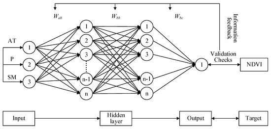
Figure 2.
The structure of the artificial neural network model.
The model was developed via MATLAB R2016a, of which the model training function is “trainbr”, the transfer function is “tansig”, and data segmentation is in “dividerand” random form. The model will automatically select 70% of the sample data for training and the remaining 30% for testing. The performance of the model is evaluated by the root mean square error (MSE). Last, the determination coefficient (R2), relative bias (bias) and Nash efficiency coefficient (NSE) were used to evaluate the simulation accuracy of the ANN. The formula is as follows:
where Ondvi is the average value of MODIS NDVI, Sndvi is the NDVI obtained by model simulation, and m is the number of samples. The R2 value determines the degree of correlation: the closer the R2 value is to 1, the closer the model NDVI simulation value is to the MODIS NDVI value, and the higher the goodness of fit of the model. Relative bias indicates the degree of numerical deviation between the NDVI simulation value of the inverse model and the MODIS NDVI value. The closer bias is to 0, the higher the model simulation accuracy is. The value of NSE ranges from minus infinity to 1, where the closer the NSE value is to 1, the better the model quality and the higher the model credibility. An NSE close to 0 indicates that the simulation results are close to the average level of the MODIS NDVI values. An NSE much less than 0 indicates that the model cannot be trusted.
The contribution of each environmental factor to the NDVI in the ANN model is also calculated by the connection weight method proposed by Garson [42], and the formula is as follows:
where ACi and RCi represent the absolute and relative contributions of the ith input to the kth output, respectively; a, b and c represent the number of neurons in the input layer, hidden layer and output layer of the model, respectively.
3. Results
3.1. Vegetation Dynamics Variations
3.1.1. Spatiotemporal Variations
According to Figure 3, the increasing trend of growing season NDVI is apparent with a 22% increase in the past 16 years. The linear relationship correlation coefficient is r = sqrt (0.475) = 0.690 (p < 0.05), which confirms a significant relationship with an increasing rate of 0.001/year.
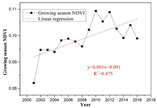
Figure 3.
The variation of the Normalized Difference Vegetation Index (NDVI) in the Qaidam Basin.
The spatial distribution of the growing season NDVI from 2001 to 2016 is shown in Figure 4. The results show that the NDVI ranged from 0 to 0.46, with an average value of 0.10. However, the standard deviation reached 0.08, which suggests that spatial variation was considerable. As can be seen from Figure 4, the value of NDVI in the growing season gradually decreased from the southeast to the northwest. The statistical results indicate that the area with an NDVI value greater than 0.3 in the growing season accounted for 20.27% of the basin area, most of which occurred in the southeast region. The area with growing season NDVI less than 0.05 accounted for 15.18% of the basin area, most of which occurred in the northwest region.
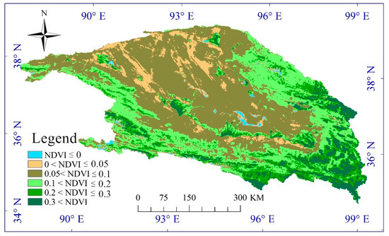
Figure 4.
The spatial distribution of the average growing season NDVI from 2001 to 2016.
3.1.2. Spatial Trend Variations
Figure 5 shows the NDVI changes in the basin. Figure 5a shows an increasing trend of varying degrees from 2001 to 2016, and the increasing trend was obvious in the southeastern of the Basin, Qilian Mountains and the southwestern Kunlun Mountains. The areas showing a downward trend are mainly distributed around the lake in the center of the basin, and the main reason may be that the increase in lake area leads to the death of vegetation, resulting in the decline of NDVI.
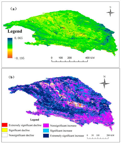
Figure 5.
The variation trends (a) and significances (b) of the NDVI in the Qaidam Basin 2001–2016.
Figure 5b shows the significances of the growing season NDVI changes. The increasing area was over 55% of the total area. It is worth noting that regions with extremely significant increasing trends accounted for 34.98% of the basin area, mainly concentrated in the basin region near the Kunlun Mountain (southeast region) and Qilian Mountain (northeast region). In contrast, the proportion of growing season NDVI decreasing regions (including nonsignificant decline, significant decline and extremely significant decline) was less than 10% of the total area. The reason was supposed to be the increased vegetation submerged in the lake in recent years, which has led to a decrease in NDVI. Table 1 presents the statistics of the NDVI variation trends.

Table 1.
Statistics of the NDVI variation trend in the Qaidam Basin.
3.1.3. Vegetation Dynamics with Elevation
Along with altitudes, the distribution of vegetation also has a noticeable difference, shown in Figure 4. Therefore, it is of great significance for vegetation restoration and ecological protection in the complex topography (2653–6748 m) of Qaidam Basin to deeply understand the law of vegetation dynamics with elevation.
We divided the elevation into individual 200 m bins (2600–6600 m) for the detailed analysis, and the NDVI variations at different elevation belts are shown in Figure 6. It can be found that the NDVI gradually increased 0.06 at 2600–2800 m, sharply increased 0.12 at 4400–4600 m, decreased to 0.01 at 5400–5600 m, and fell to 0 when above 5600 m. The peak values of the NDVI appeared along the elevation gradient at 4400–4600 m.
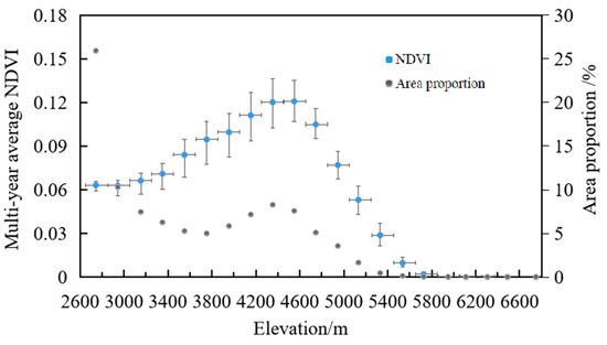
Figure 6.
Multi-year average NDVI variations along the elevations.
In addition, we analyzed the change rates of NDVI and environmental factors at different elevation gradients from 2001 to 2016. As shown in Figure 7, the largest increasing rates of NDVI, precipitation, AT and SM occurred at the elevation bin of 4000~4200 m, 4400 m, 2800 m and 4600~5600 m (except 5000 m), respectively. The regions with a higher rate of NDVI increase are close to those with higher rates of precipitation increase, which may be an important factor for the increase in NDVI.
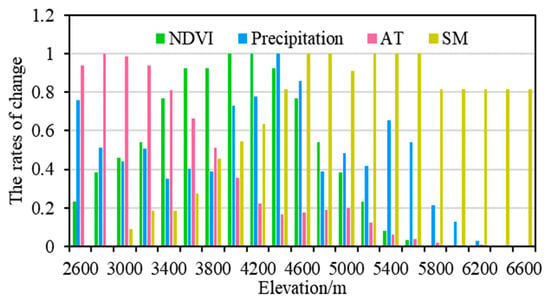
Figure 7.
Changing rates of NDVI and impact factors at different elevations from 2001 to 2016.
3.2. Responses of Vegetation Dynamics to Environmental Factors
3.2.1. Spatial Response
The dynamic change process of vegetation is very complex. If the relative contribution of various environmental factors is not clear, the driving force of vegetation’s dynamic activity will be hard to recognize. Figure 8a shows the significance of the spatial pattern NDVI–precipitation correlation. In the Qaidam Basin, an area of 74.1% shows a positive relationship between the NDVI and precipitation, but only 18.25% of them passed the significance test (including significant and extremely significant increases). These areas, which have more precipitation, are mainly distributed in the Kunlun Mountains in the southeast and the Qilian Mountains in the northeast of the basin.
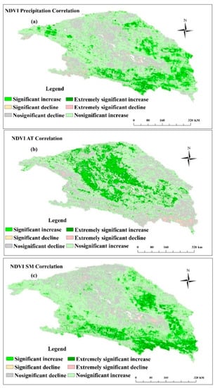
Figure 8.
Spatial pattern of NDVI and precipitation (a), accumulative temperature (AT) (b) and soil moisture (SM) (c) correlation significance.
It can be seen from Figure 8b that the area of 57.5% shows a positive relationship between the NDVI and AT. However, only 16.5% of them passed the significance test (including significant and extremely significant increases). These areas are mainly distributed in the center and northwest of the Qaidam Basin. It is worth noting that in the growing season, NDVI is negatively correlated with the AT in the southern, southeastern and northeastern alpine regions of the basin. However, these areas are positively correlated with precipitation and SM.
Figure 8c shows the NDVI and SM correlation significance. The area of 76.4% shows a positive relationship between the growing season NDVI and SM, and only 19.9% of them passed the significance test (including significant and extremely significant increases). These regions are mainly distributed in the Kunlun Mountains in the southeast, the oasis area in the Piedmont Plain and the Qilian Mountains in the northeast of the basin.
3.2.2. Relationship Among Pixel-Level NDVI and Environmental Factors
Usually, the precipitation, AT and SM are considered critical factors to vegetation dynamics [43,44]. However, along the elevation gradient, the factor change’s combined effects on vegetation dynamics are still unclear [45]. To test the relations, we explored at a pixel scale based on the distribution data of elevation, NDVI, precipitation, AT and SM in the years from 2001 to 2016. The results are shown in Figure 9 and Table 2.
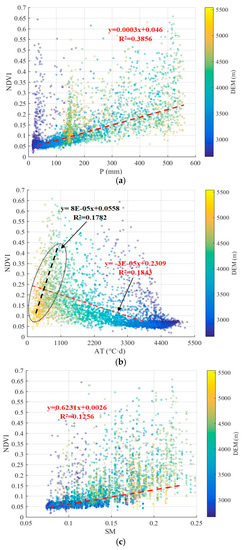
Figure 9.
The relationship among NDVI, DEM and AT (a), precipitation (b) and SM (c).

Table 2.
Correlation between NDVI and environmental factors.
As shown in Figure 9a, when the elevation is lower than 2900 m, the precipitation is 0–110 mm, the high NDVI value is mainly concentrated in the low-elevation area, indicating that the NDVI in the region is less affected by precipitation. When the elevation is from 2900 to 3900 m, the NDVI increases with increasing precipitation, which indicates that the precipitation is one of the main factors affecting the NDVI in this altitude range. When the altitude is higher than 3900 m, there is no apparent correlation between precipitation and the NDVI, indicating that precipitation is not the main controlling factor of the NDVI. As a whole, there is a significant positive correlation between NDVI and precipitation with a correlation coefficient of 0.562 (p < 0.01), as shown in Table 2.
As the AT and NDVI, it showed a significant negative correlation (p < 0.01) illustrated in Table 2. However, when AT was less than 1100 °C most located the area of elevation > 4500 m, with a decrease in elevation, the AT and NDVI gradually increased, presenting a positive correlation and indicating that temperature is an important factor for the dynamic change in vegetation in high-altitude areas. When the AT is from 1100 to 4400 °C, the NDVI is relatively dispersed. With the decrease in altitude, the AT gradually increased, and the whole NDVI presented a decreasing trend. When the AT is greater than 4400 °C, the corresponding elevation is mostly below 3000 m, and then, the NDVI is low and has an obvious aggregation (Figure 9b).
Similarly, as shown in Figure 9c, the SM was approximately 0.15 in the low-elevation area due to the high temperature and evaporation. The NDVI is mainly concentrated in the low-value area, about 0.05. In the high-elevation range, the SM increased significantly, while the NDVI is no longer centralized in the low-value place, and the distribution became relatively homogeneous. Overall, the SM and NDVI exhibited a significant positive correlation, with a correlation coefficient of 0.507, as shown in Table 2.
3.3. Exploration of the Relative Contribution Rate of Environmental Factors
Taking the relation between NDVI and impact factors fitted along with elevations, we found the maximum inclusive elevation range and the best correlation coefficient from the fitting results. Three elevation belts were finally divided: elevation ≤ 2900 m; 2900 < elevation ≤ 3900 m and elevation > 3900 m. Then, the model was trained and tested by the raster data of elevation, NDVI, precipitation, AT and SM from 2001 to 2016. The fitting relations of the three elevation intervals were obtained. The linear regression results of the simulated NDVI and MODIS NDVI are shown in Figure 10 and Table 3.
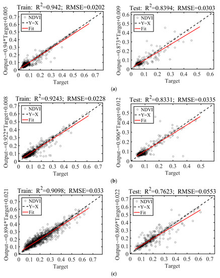
Figure 10.
Fitting results of the impact factors related to NDVI in the elevation of (a) <2900 m, (b) 2900–3900 m, (c) >3900 m.

Table 3.
Model accuracy evaluation parameters.
Figure 10 and Table 3 show that the number of hidden layers in each model is 2. The number of hidden layer neurons in the low- and middle-elevation models is 11, while in the high-elevation model it is 25, showing that the effects of comprehensive environmental factors on the NDVI are more complex and more challenging than those of the low- and middle-elevation models.
It was also found at the low elevations (<2900 m) that the simulation accuracy of training R2 was the highest at 0.9420, the corresponding RMSE was the lowest (0.0202), and the testing R2 reached 0.8394 (Figure 10a and Table 3). It indicates that the NDVI is highly correlated with the precipitation, AT and SM within this elevation range. When the elevation is greater than 3900 m, R2 is relatively lower both in the training and test periods: 0.9098 in the training and 0.7623 in the test period (Figure 10c and Table 3). This indicates that the NDVI in the high-elevation area is correlated to the precipitation, AT and SM to a certain extent, and it also is affected by other factors. In the mid-elevation region (2900–3900 m), the R2 and RMSE for both the training and test are within the ranges of the other two models (Figure 10b and Table 3). The NSE values of the three models are 0.9016, 0.8981 and 0.8741, respectively, and the constructed model is reliable overall.
According to the ANN model, the relative contribution rate of precipitation, AT and SM to vegetation dynamics is calculated as shown in Table 4.

Table 4.
Relative contribution rate of environmental factors of NDVI dynamics (%).
4. Discussion
In arid and high-altitude areas, the vegetation dynamics are susceptible to climate change [46]. The distribution of vegetation is often controlled by climate models, showing a non-stationary, nonlinear complex process [47]. Therefore, it is difficult to describe the relations between vegetation and environmental factors only with the traditional correlation analysis method. In this study, we used machine learning to build an artificial neural network fitting model to quantitatively simulate and analyze the influences and contributions of various environmental factors on vegetation dynamics.
Precipitation, AT and SM are the three major environmental factors impacting the spatiotemporal vegetation distribution [48,49,50]. Table 2 shows a significant positive relationship between the NDVI and precipitation, with a correlation coefficient of 0.562. Spatially, the NDVI in the Kunlun Mountains in the southeast of the basin and Qilian Mountain in the northeast of the basin showed a very significant correlation with precipitation (Figure 4). In most cases, more precipitation will promote vegetation restoration, especially in arid and semi-arid regions, where SM is the key factor [51,52]. Zhu et al. [53] showed that precipitation was the main factor determining the basic vegetation distribution pattern in the Qaidam Basin and impacted vegetation growth. Furthermore, this study found that precipitation, as the dominant factor, contributed 44.76% to the vegetation dynamics in elevation areas of between 2900 and 3900 m (see Table 4). This was considered mainly to be because of the low mountainous area in the southeast close to the humidity source of the Indian Ocean. Under the influence of a strong monsoon, the windward slope generates more precipitation in the growing season [53], promoting vegetation growth and has higher vegetation coverage, making precipitation the leading factor in this region.
In this region, a significant negative relationship between vegetation growth and AT exists. However, as the topographic height difference of the Qaidam Basin is 4095 m, the environmental conditions of different elevations are also greatly different, which have different influences on the vegetation in this area. As shown in Figure 9b, the AT is negatively correlated with the NDVI overall but positively correlated with the NDVI in high-altitude regions. According to Table 2, when the elevation is higher than 3900 m, the relative contribution rate of AT reaches 39.50%. It is shown that AT has the greatest influence on the NDVI within this region. We know that the temperature in the high mountain area around the Qaidam Basin is lower, which plays a dominant role in vegetation growth and change. This result is consistent with the commonly accepted knowledge in this area of research.
In general, the rise of surface temperature extends the growing season in the high northern latitudes and promotes vegetation growth [54,55]. However, on the other hand, due to continued global warming, the surface temperature may inhibit vegetation growth and lead to vegetation degradation due to drought caused by warming. In this study, it can be found that when the elevation is between 2900 and 3900 m, the relative contribution of precipitation is 44.76. This finding indicates that the drought caused by temperature rise may affect vegetation growth in this region. Many studies have shown that drought has resulted in the delay of the start of the growing season (SGS) in grassland ecosystems in Northeast China [22], declining in net ecosystem productivity (NEP) [56], and reduction in water use efficiency (WUE) [57].
SM plays a vital role in vegetation restoration and community succession, and maintains extra water from melting glaciers, ice and precipitation in arid and semi-arid regions. Affected by precipitation, air temperature, vegetation, soil texture, topography and other factors, the spatiotemporal distribution of SM shows strong heterogeneity, especially in the cold alpine mountainous areas [58,59]. There is a significant positive relationship between vegetation dynamics and SM in this region, with a correlation coefficient of 0.507 (Table 2). In terms of spatial distribution, the areas with significant correlation were mainly distributed in the southeast of the basin and the central basin of the front edge of the oasis core area along Golmud-Nuomuhong. Saline and alkaline wetlands are mostly distributed in these places, and the flat terrain and relatively dense runoff make up for the lack of precipitation [53], which leads to the growth of dense halophytic vegetation in these places.
5. Conclusions
In the Qaidam Basin, the NDVI in growing season ranged from 0 to 0.46, with an average value of 0.10. The region has undergone a remarkable vegetation restoration process with an increasing rate of 0.001/year (p < 0.05). Regions with significantly increasing NDVI were mainly found in the Kunlun Mountain Basin (southeast region) and Qilian Mountain Basin (northeast region). Analysis of the vegetation dynamics with elevation indicated that the vegetation coverage in low altitude areas was better than that in high altitude areas, and the peak values of NDVI appeared along the elevation gradient at 4400–4600 m.
In this study, the NDVI was significantly correlated with precipitation, AT and SM (p < 0.01), the contribution rate of each factor was found along with three altitude ranges. In the low-elevation region (<2900 m), the contribution rate of AT to the NDVI dynamic was the largest (35.17%). In the mid-altitude area (2900–3900 m), the contribution rate of precipitation (44.76%) was significantly higher than that of AT (27.93%) and SM (27.31%). When the altitude was higher than 3900 m, the contribution rates of AT (39.50%) and SM (38.53%) had no significant difference and were much higher than that of precipitation (21.97%).
Our analysis suggests that the NDVI dynamics are closely related to precipitation, AT and SM, and different environmental factors have different contributions to vegetation dynamics at different elevations. The comprehensive relations between vegetation dynamics and environmental factors may improve the eco-environmental management and desertification control for this region and other similar arid mountain-basin systems.
It is highlighted that machine learning is an effective method to quantitatively identify the contribution of impacts to changes in vegetation dynamics, especially in analyzing large and complex systems. It is hoped that this research will serve as the foundation for future studies that are similar in nature.
Author Contributions
Conceptualization, G.X. and J.L.; methodology, G.X.; software, G.X.; validation, J.L., Z.Y. and G.X.; formal analysis, J.L.; investigation, J.L.; resources, G.X.; data curation, S.N.; writing—original draft preparation, J.L.; writing—review and editing, G.X.; visualization, Z.W.; supervision, Z.W.; project administration, Z.W.; funding acquisition, Z.W. All authors have read and agreed to the published version of the manuscript.
Funding
This research was funded by the National Key Research and Development Program (2016YFC0402900), the National Natural Science Foundation of China (41671020), and the Key Research and Development Program of Ningxia (2020BCF01002).
Institutional Review Board Statement
Not applicable.
Informed Consent Statement
Not applicable.
Data Availability Statement
The data examined in this paper are available at http://doi.org/10.5281/zenodo.4633147 (accessed on 24 March 2021).
Acknowledgments
We would like to thank the editor and anonymous reviewers for their comments, which helped improve the manuscript.
Conflicts of Interest
The authors declare no conflict of interest.
References
- Wang, J.; Wang, K.L.; Zhang, M.Y.; Zhang, C.H. Impacts of climate change and human activities on vegetation cover in hilly southern China. Ecol. Eng. 2015, 81, 451–461. [Google Scholar] [CrossRef]
- Zoungrana, B.J.B.; Conrad, C.; Thiel, M.; Amekudzi, L.K.; Da, E.D. MODIS NDVI trends and fractional land cover change for improved assessments of vegetation degradation in Burkina Faso, West Africa. J. Arid Environ. 2018, 153, 66–75. [Google Scholar] [CrossRef]
- Wang, Z.J.; Wang, H.F.; Lei, Z.D. Stability analysis of oasis in arid region. J. Hydraul. Eng. 2002, 5, 26–30. [Google Scholar]
- Zhao, Q.; Ma, X.; Liang, L.; Yao, W. Spatial-Temporal Variation Characteristics of Multiple Meteorological Variables and Vegetation over the Loess Plateau Region. Appl. Sci. 2020, 10, 1000. [Google Scholar] [CrossRef]
- Pettorelli, N.; Vik, J.O.; Mysterud, A.; Gaillard, J.M.; Tucker, C.J.; Stenseth, N.C. Using the satellite-derived NDVI to assess ecological responses to environmental change. Trends Ecol. Evol. 2005, 20, 503–510. [Google Scholar] [CrossRef] [PubMed]
- Zhang, Y.L.; Gao, J.G.; Liu, L.S.; Wang, Z.F.; Ding, M.J.; Yang, X.C. NDVI-based vegetation changes and their responses to climate change from 1982 to 2011: A case study in the Koshi River Basin in the middle Himalayas. Glob. Planet. Chang. 2013, 108, 139–148. [Google Scholar] [CrossRef]
- Turner, B., II; Meyer, L.; William, B. Land use and land cover in global environmental change: Considerations for study. Int. Soc. Sci. J. 1991, 43, 669–679. [Google Scholar]
- Martinez, B.; Gilabert, M.A. Vegetation dynamics from NDVI time series analysis using the wavelet transform. Remote Sens. Environ. 2009, 113, 1823–1842. [Google Scholar] [CrossRef]
- Magidi, J.; Nhamo, L.; Mpandeli, S.; Mabhaudhi, T. Application of the Random Forest Classifier to Map Irrigated Areas Using Google Earth Engine. Remote Sens. 2021, 13, 876. [Google Scholar] [CrossRef]
- Tucker, C.J.; Slayback, D.A.; Pinzon, J.E.; Los, S.O.; Myneni, R.B.; Taylor, M.G. Higher northern latitude normalized difference vegetation index and growing season trends from 1982 to 1999. Int. J. Biometeorol. 2001, 45, 184–190. [Google Scholar] [CrossRef]
- Reddy, D.S.; Prasad, P.R.C. Prediction of vegetation dynamics using NDVI time series data and LSTM. Modeling Earth Syst. Environ. 2018, 4, 409–419. [Google Scholar] [CrossRef]
- Yang, H.B.; Yang, D.W.; Lei, Z.D.; Sun, F.B. New analytical derivation of the mean annual water-energy balance equation. Water Resour. Res. 2008, 44, 893–897. [Google Scholar] [CrossRef]
- Lei, J.I.; Peters, A.J. A spatial regression procedure for evaluating the relationship between AVHRR-NDVI and climate in the northern Great Plains. Int. J. Remote Sens. 2004, 25, 297–311. [Google Scholar]
- Potter, C.S.; Brooks, V. Global analysis of empirical relations between annual climate and seasonality of NDVI. Int. J. Remote Sens. 1998, 19, 2921–2948. [Google Scholar] [CrossRef]
- Gu, Z.J.; Duan, X.W.; Shi, Y.D.; Li, Y.; Pan, X. Spatiotemporal variation in vegetation coverage and its response to climatic factors in the Red River Basin, China. Ecol. Indic. 2018, 93, 54–64. [Google Scholar] [CrossRef]
- Liu, X.F.; Zhang, J.S.; Zhu, X.F.; Pan, Y.Z.; Liu, Y.X.; Zhang, D.H.; Lin, Z.H. Spatiotemporal changes in vegetation coverage and its driving factors in the Three-River Headwaters Region during 2000–2011. J. Geogr. Sci. 2014, 24, 288–302. [Google Scholar] [CrossRef]
- Neilson, R.P. A Model for Predicting Continental-Scale Vegetation Distribution and Water-Balance. Ecol. Appl. 1995, 5, 362–385. [Google Scholar] [CrossRef]
- Chen, B.; Chen, J.M.; Ju, W. Remote sensing-based ecosystem–atmosphere simulation scheme (EASS)—Model formulation and test with multiple-year data. Ecol. Model. 2007, 209, 277–300. [Google Scholar] [CrossRef]
- Sitch, S.; Smith, B.; Prentice, I.C.; Arneth, A.; Bondeau, A.; Cramer, W.; Kaplan, J.O.; Levis, S.; Lucht, W.; Sykes, M.T.; et al. Evaluation of ecosystem dynamics, plant geography and terrestrial carbon cycling in the LPJ dynamic global vegetation model. Glob. Chang. Biol. 2003, 9, 161–185. [Google Scholar] [CrossRef]
- Sato, H.; Itoh, A.; Kohyama, T. SEIB–DGVM: A new Dynamic Global Vegetation Model using a spatially explicit individual-based approach. Ecol. Model. 2007, 200, 279–307. [Google Scholar] [CrossRef]
- Foley, J.A.; Prentice, I.C.; Ramankutty, N.; Levis, S.; Pollard, D.; Sitch, S.; Haxeltine, A. An integrated biosphere model of land surface processes, terrestrial carbon balance, and vegetation dynamics. Glob. Biogeochem. Cycles 1996, 10, 603–628. [Google Scholar] [CrossRef]
- Yuan, M.; Zhao, L.; Lin, A.; Wang, L.; Li, Q.; She, D.; Qu, S. Impacts of preseason drought on vegetation spring phenology across the Northeast China Transect. Sci. Total Enviorn. 2020, 738, 140297. [Google Scholar] [CrossRef]
- Praticò, S.; Solano, F.; Di Fazio, S.; Modica, G. Machine Learning Classification of Mediterranean Forest Habitats in Google Earth Engine Based on Seasonal Sentinel-2 Time-Series and Input Image Composition Optimisation. Remote Sens. 2021, 13, 586. [Google Scholar] [CrossRef]
- Buckland, C.E.; Bailey, R.M.; Thomas, D.S.G. Using artificial neural networks to predict future dryland responses to human and climate disturbances. Sci. Rep. 2019, 9, 3855. [Google Scholar] [CrossRef] [PubMed]
- Benliay, A.; Yilmaz, T.; Olgun, R.; Ak, M.K. NDVI indicated changes in vegetation and their relations to climatic comfort factors in Demre-Akcay Sub-basin, Turkey. J. Environ. Biol. 2020, 41, 344–350. [Google Scholar] [CrossRef]
- Fu, Y.; Chen, H.; Niu, H.H.; Zhang, S.Q.; Yang, Y. Spatial and temporal variation of vegetation phenology and its response to climate changes in Qaidam Basin from 2000 to 2015. J. Geogr. Sci. 2018, 28, 400–414. [Google Scholar] [CrossRef]
- Qi, Y.; Li, S.; Ran, Y.; Wang, H.; Wu, J.; Lian, X.; Luo, D. Mapping Frozen Ground in the Qilian Mountains in 2004–2019 Using Google Earth Engine Cloud Computing. Remote Sens. 2021, 13, 149. [Google Scholar] [CrossRef]
- Zhou, Y.; Fan, J.; Wang, X. Assessment of varying changes of vegetation and the response to climatic factors using GIMMS NDVI3g on the Tibetan Plateau. PLoS ONE 2020, 15, e0234848. [Google Scholar] [CrossRef] [PubMed]
- Sun, Y.; Liu, S.; Dong, Y.; Dong, S.; Shi, F. Effects of multi-time scales drought on vegetation dynamics in Qaidam River Basin, Qinghai-Tibet Plateau from 1998 to 2015. Theor. Appl. Climatol. 2020, 141, 117–131. [Google Scholar] [CrossRef]
- Jin, X.; Liu, J.; Wang, S.; Xia, W. Vegetation dynamics and their response to groundwater and climate variables in Qaidam Basin, China. Int. J. Remote Sens. 2016, 37, 710–728. [Google Scholar] [CrossRef]
- Xu, G.Y.; Wang, Z.J.; Hu, Z.D.; Zhang, J.X. Evaluation of land use/cover change and land use grade in Qaidam basin, China. J. Hydroelectr. Eng. 2019, 38, 44–55. [Google Scholar] [CrossRef]
- Wan, Z. New refinements and validation of the collection-6 MODIS land-surface temperature/emissivity product. Remote Sens. Environ. 2014, 140, 36–45. [Google Scholar] [CrossRef]
- Cui, X.; Cheng, Y.; Zhang, L.; Wei, X. Spatial Interpolation of MODIS Land Surface Temperature Products Based on DEM Correction. J. Geo-Inf. Sci. 2018, 20, 1768–1776. [Google Scholar]
- Geerts, B. Empirical estimation of the annual range of monthly-mean temperatures. Theor. Appl. Climatol. 2002, 73, 107–132. [Google Scholar] [CrossRef]
- Xu, G.Y.; Wang, Z.J.; Xia, T. Mapping Areal Precipitation with Fusion Data by ANN Machine Learning in Sparse Gauged Region. Appl. Sci. 2019, 9, 2294. [Google Scholar] [CrossRef]
- GLDAS Noah Land Surface Model L4 Monthly 0.25 × 0.25 Degree V2.1. Available online: https://disc.gsfc.nasa.gov/datasets/GLDAS_NOAH025_M_2.1/summary?keywords=GLDAS (accessed on 17 December 2018).
- Nyeko-Ogiramoi, P.; Willems, P.; Ngirane-Katashaya, G. Trend and variability in observed hydrometeorological extremes in the Lake Victoria basin. J. Hydrol. 2013, 489, 56–73. [Google Scholar] [CrossRef]
- Mo, K.L.; Chen, Q.W.; Chen, C.; Zhang, J.Y.; Wang, L.; Bao, Z.X. Spatiotemporal variation of correlation between vegetation cover and precipitation in an arid mountain-oasis river basin in northwest China. J. Hydrol. 2019, 574, 138–147. [Google Scholar] [CrossRef]
- Kang, C.; Zhang, Y.L.; Wang, Z.F.; Liu, L.S.; Zhang, H.M.; Jo, Y. The Driving Force Analysis of NDVI Dynamics in the Trans-Boundary Tumen River Basin between 2000 and 2015. Sustainability 2017, 9, 2350. [Google Scholar] [CrossRef]
- Yue, S.; Wang, C.Y. Applicability of prewhitening to eliminate the influence of serial correlation on the Mann-Kendall test. Water Resour. Res. 2002, 38, 1–7. [Google Scholar] [CrossRef]
- Deswal, S.; Pal, M. Artificial Neural Network based Modeling of Evaporation Losses in Reservoirs. World Acad. Sci. Eng. Technol. 2008, 29, 279–283. [Google Scholar]
- Garson, G.D. Interpreting neural-network connection weights. AI Expert 1991, 6, 47–51. [Google Scholar]
- Nemani, R.R.; Keeling, C.D.; Hashimoto, H.; Jolly, W.M.; Piper, S.C.; Tucker, C.J.; Myneni, R.B.; Running, S.W. Climate-driven increases in global terrestrial net primary production from 1982 to 1999. Science 2003, 300, 1560–1563. [Google Scholar] [CrossRef]
- Churkina, G.; Running, S.W. Contrasting climatic controls on the estimated productivity of global terrestrial biomes. Ecosystems 1998, 1, 206–215. [Google Scholar] [CrossRef]
- Liu, L.B.; Wang, Y.; Wang, Z.; Li, D.L.; Zhang, Y.T.; Qin, D.H.; Li, S.C. Elevation-dependent decline in vegetation greening rate driven by increasing dryness based on three satellite NDVI datasets on the Tibetan Plateau. Ecol. Indic. 2019, 107, 105569. [Google Scholar] [CrossRef]
- Li, Y.; Liu, C.; Yu, W.; Tian, D.; Bai, P. Response of streamflow to environmental changes: A Budyko-type analysis based on 144 river basins over China. Sci. Total Environ. 2019, 664, 824–833. [Google Scholar] [CrossRef] [PubMed]
- Liu, H.; Zhang, M.; Lin, Z.; Xu, X. Spatial heterogeneity of the relationship between vegetation dynamics and climate change and their driving forces at multiple time scales in Southwest China. Agric. For. Meteorol. 2018, 256–257, 10–21. [Google Scholar] [CrossRef]
- Ding, B.H.; Yang, K.; Qin, J.; Wang, L.; Chen, Y.Y.; He, X.B. The dependence of precipitation types on surface elevation and meteorological conditions and its parameterization. J. Hydrol. 2014, 513, 154–163. [Google Scholar] [CrossRef]
- Bagnoud, N.; Pitman, A.J.; McAvaney, B.J.; Holbrook, N.J. The contribution of the land surface energy balance complexity to differences in means, variances and extremes using the AMIP-II methodology. Clim. Dyn. 2005, 25, 171–188. [Google Scholar] [CrossRef]
- Blanken, P.D.; Black, T.A.; Neumann, H.H.; den Hartog, G.; Yang, P.C.; Nesic, Z.; Lee, X. The seasonal water and energy exchange above and within a boreal aspen forest. J. Hydrol. 2001, 245, 118–136. [Google Scholar] [CrossRef]
- Xue, T.; Tang, G.; Sun, L.; Wu, Y.; Liu, Y. Long-term trends in precipitation and precipitation extremes and underlying mechanisms in the U.S. Great Basin during 1951–2013. J. Geophys. Res. Atmos. 2017, 122, 6152–6169. [Google Scholar] [CrossRef]
- Zhou, J.; Cai, W.; Qin, Y.; Lai, L.; Guan, T.; Zhang, X.; Jiang, L.; Du, H.; Yang, D.; Cong, Z.; et al. Alpine vegetation phenology dynamic over 16years and its covariation with climate in a semi-arid region of China. Sci. Total Environ. 2016, 572, 119–128. [Google Scholar] [CrossRef] [PubMed]
- Zhu, W.B.; Lv, A.F.; Jia, S.F. Study on Spatial Distribution of Vegetation Coverage and Its Affecting Factors in the Qaidam Basin Based on NDVI. Arid Zone Res. 2010, 27, 691–698. [Google Scholar]
- Piao, S.L.; Fang, J.Y.; Zhou, L.M.; Ciais, P.; Zhu, B. Variations in satellite-derived phenology in China’s temperate vegetation. Glob. Chang. Biol. 2006, 12, 672–685. [Google Scholar] [CrossRef]
- Zhou, L.M.; Tucker, C.J.; Kaufmann, R.K.; Slayback, D.; Shabanov, N.V.; Myneni, R.B. Variations in northern vegetation activity inferred from satellite data of vegetation index during 1981 to 1999. J. Geophys. Res. Atmos. 2001, 106, 20069–20083. [Google Scholar] [CrossRef]
- Liu, Y.; Zhou, Y.; Ju, W.; Wang, S.; Wu, X.; He, M.; Zhu, G. Impacts of droughts on carbon sequestration by China’s terrestrial ecosystems from 2000 to 2011. Biogeosciences 2014, 11, 2583–2599. [Google Scholar] [CrossRef]
- Xu, H.J.; Wang, X.P.; Zhao, C.Y.; Zhang, X.X. Responses of ecosystem water use efficiency to meteorological drought under different biomes and drought magnitudes in northern China. Agric. For. Meteorol. 2019, 278, 107660. [Google Scholar] [CrossRef]
- Wei, W.; Feng, X.; Yang, L.; Chen, L.; Feng, T.; Chen, D. The effects of terracing and vegetation on soil moisture retention in a dry hilly catchment in China. Sci. Total Environ. 2019, 647, 1323–1332. [Google Scholar] [CrossRef]
- Pangaluru, K.; Velicogna, I.; Geruo, A.; Mohajerani, Y.; Ciracì, E.; Cpepa, S.; Basha, G.; Rao, S.V.B. Soil moisture variability in India: Relationship with land-surface atmospheric fields using Maximum Covariance Analysis. Remote Sens. 2019, 11, 335. [Google Scholar] [CrossRef]
Publisher’s Note: MDPI stays neutral with regard to jurisdictional claims in published maps and institutional affiliations. |
© 2021 by the authors. Licensee MDPI, Basel, Switzerland. This article is an open access article distributed under the terms and conditions of the Creative Commons Attribution (CC BY) license (http://creativecommons.org/licenses/by/4.0/).