Article

Airborne Lidar Survey, Density-Based Clustering, and Ancient Maya Settlement in the Upper Usumacinta River Region of Mexico and Guatemala

1
Department of Anthropology, Brandeis University, Waltham, MA 02453, USA
2
Department of Anthropology, Brown University, Providence, RI 02912, USA
3
Center for Latin American Studies and Florida Institute for Built Environment Resilience, Gainesville, FL 32611, USA
4
Department of Anthropology, McMaster University, Hamilton, ON L8S 4L9, Canada
5
National Center for Airborne Laser Mapping, University of Houston, Houston, TX 77204, USA
6
Facultad de Ciencias Antropológicas, Universidad Autónoma de Yucatán, Merida, Yucatán, MX 97305, USA
7
Education Department, Los Angeles County Museum of Art, Los Angeles, CA 90036, USA
*
Author to whom correspondence should be addressed.
Remote Sens. 2021, 13(20), 4109; https://doi.org/10.3390/rs13204109
Submission received: 9 September 2021 / Revised: 9 October 2021 / Accepted: 11 October 2021 / Published: 14 October 2021

Abstract

:
We present results from the archaeological analysis of 331 km2 of high-resolution airborne lidar data collected in the Upper Usumacinta River basin of Mexico and Guatemala. Multiple visualizations of the DEM and multi-spectral data from four lidar transects crossing the Classic period (AD 350–900) Maya kingdoms centered on the sites of Piedras Negras, La Mar, and Lacanja Tzeltal permitted the identification of ancient settlement and associated features of agricultural infrastructure. HDBSCAN (hierarchical density-based clustering of applications with noise) cluster analysis was applied to the distribution of ancient structures to define urban, peri-urban, sub-urban, and rural settlement zones. Interpretations of these remotely sensed data are informed by decades of ground-based archaeological survey and excavations, as well as a rich historical record drawn from inscribed stone monuments. Our results demonstrate that these neighboring kingdoms in three adjacent valleys exhibit divergent patterns of structure clustering and low-density urbanism, distributions of agricultural infrastructure, and economic practices during the Classic period. Beyond meeting basic subsistence needs, agricultural production in multiple areas permitted surpluses likely for the purposes of tribute, taxation, and marketing. More broadly, this research highlights the strengths of HDBSCAN to the archaeological study of settlement distributions when compared to more commonly applied methods of density-based cluster analysis.

1. Introduction

We present here the findings from the first extensive, high-resolution (>15 pulses/m2) lidar (light detection and ranging) survey in the Upper Usumacinta River region of Mexico and Guatemala, with a particular focus on significant differences in settlement patterns, settlement density, and land use in adjacent polities within this landscape of the Western Maya Lowlands. Covering ~331 km2, these data cross a region that, during the Classic period (AD 350–900), constituted portions of three distinct Maya kingdoms centered respectively on the archaeological sites known today as Piedras Negras, La Mar, and Lacanja Tzeltal (Figure 1 and Figure 2). Each capital was situated in a different, adjacent, syncline valley. We interpret the remotely sensed data through the application of HDBSCAN (hierarchical density-based clustering with noise) cluster analysis together with the results of a long running, ground-based regional archaeological survey [1,2,3,4] and a richly detailed textual record from inscribed monuments [5,6].
These research results demonstrate that the study area shows significantly lower population densities than are evident in many other published lidar surveys of the Maya region, even as it exhibits high levels of agricultural intensification. Importantly, the demonstrated patterns of settlement and agriculture in the study area are not singular: the three neighboring kingdoms show dramatically contrasting patterns of urbanization, relationships between urban and hinterland settlement, and organization of agricultural production. Considered in the context of a growing body of airborne lidar data in southeastern Mesoamerica, the research results presented here further refine our understanding of the complexity and diversity of environmental conditions, settlement patterns, population densities, urban form, and land use among the precolonial Maya [7,8,9,10,11]. After an introduction to the study region, we present the results of our spatial analyses, followed by a synthetic discussion of the implications for understanding the Classic period Maya as well as the importance of this work for modern communities in the study area.

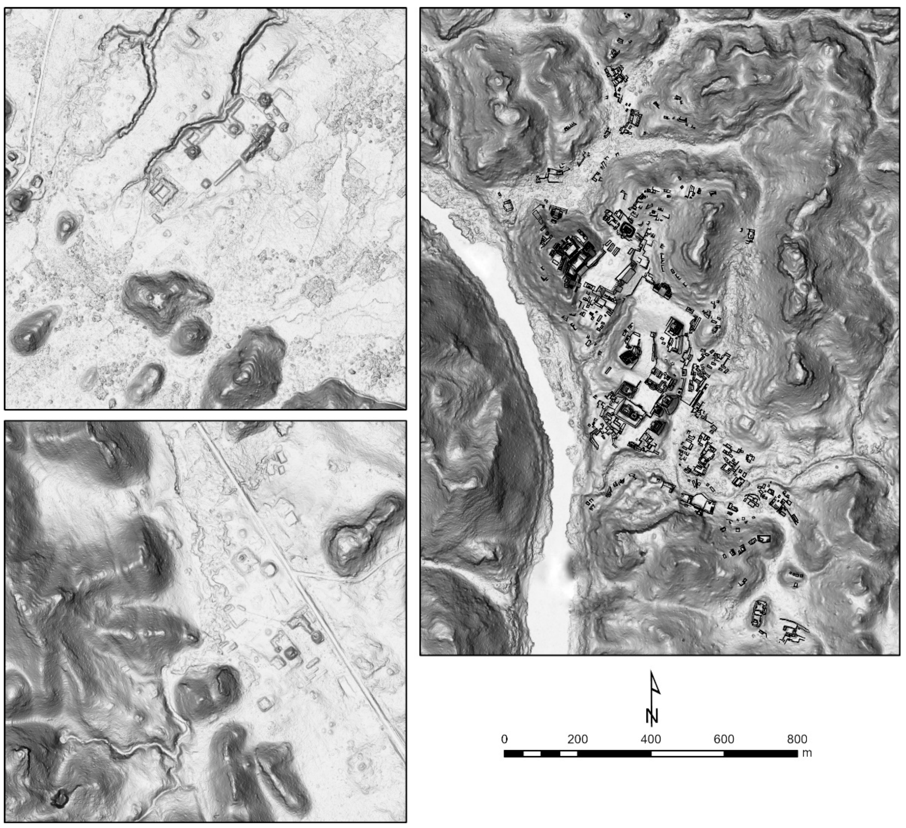
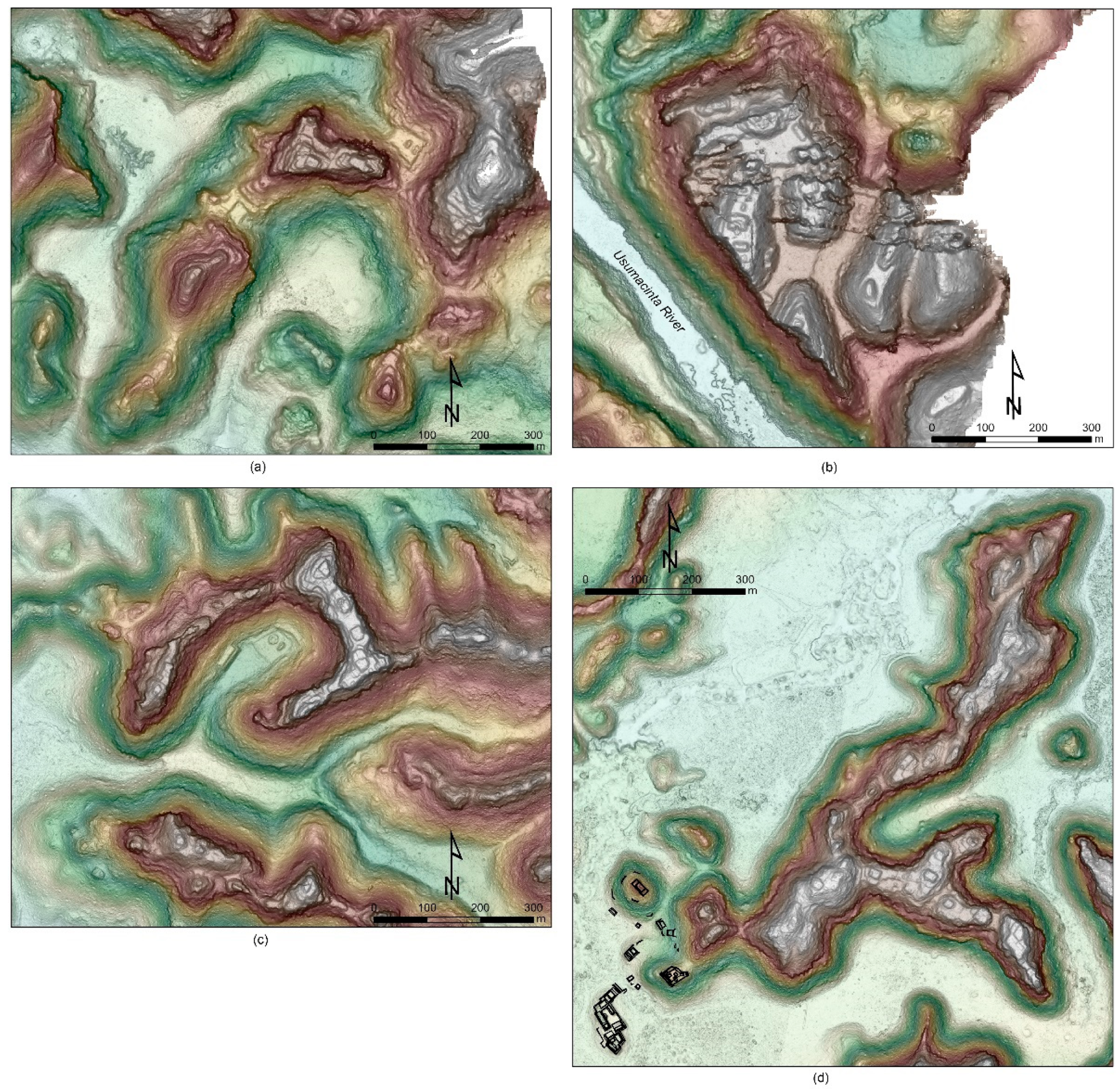
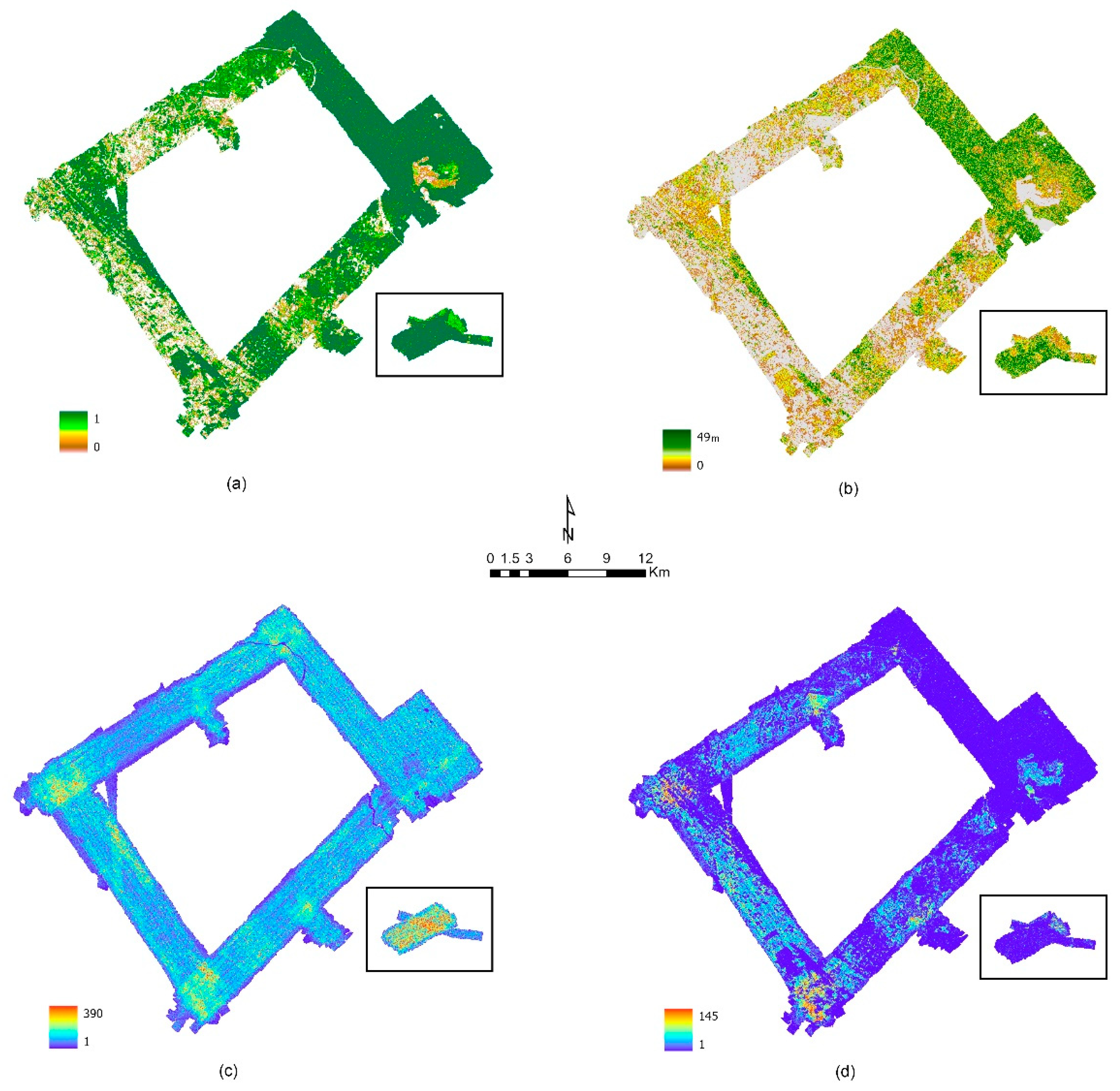
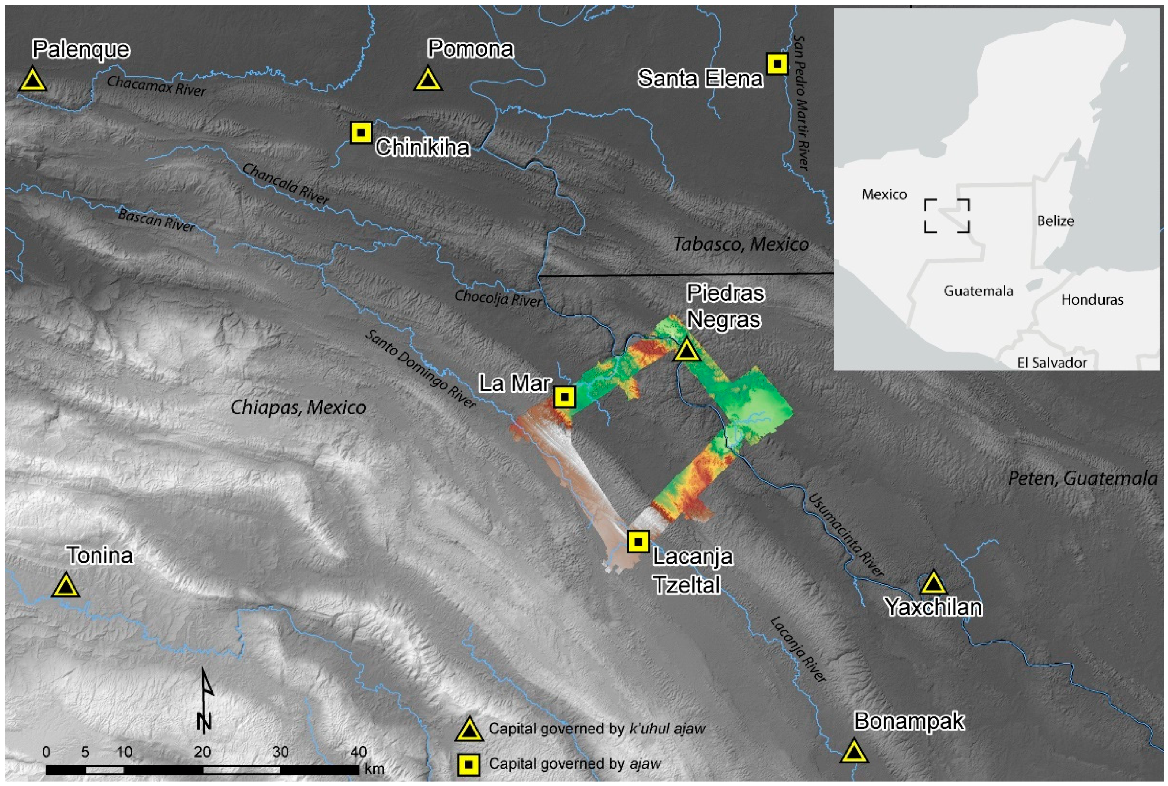
2. Materials and Methods

Excavations at Lacanja Tzeltal reveal construction as early as 774–482 cal BC (Table 1), and excavations at Piedras Negras, dated on the basis of ceramic chronologies, have yielded occupation as early as 500 BC [12,13]. However, an even deeper history of occupation is likely in the study region. Just to the northwest of Lacanja Tzeltal is the site of El Limonar. Although El Limonar has yet to be excavated, its low mounds (<1 m high) are arranged in a distinctive architectural layout, the Middle Formative Usumacinta (MFU) pattern, that in Tabasco has been definitively tied to constructions as early as ~1000 BC (Figure 3) [11]. Settlement was widespread but not dense throughout the Late Preclassic period (400 BC–AD 350), with small ritual–political centers of no more than 5 ha [1]. Inter-community conflict wracked the region at the end of the Preclassic period, when we see the construction of fortified hilltop settlements [14,15,16]. Our lidar analyses reveal for the first time the scale and wide distribution of such hilltop sites, distinguished from later settlements by their layout: a series of terraced platforms, lacking formal plazas, typically arrayed laterally along high, narrow ridges (Figure 4). Excavations in many hinterland sites, dated using ceramic chronologies, indicate that there was a general abandonment of the countryside by the Early Classic period (AD 350–600), as people flowed into a few centers that became political hubs of the Classic period [2,15].
By the beginning of the Late Classic period (AD 600–900), people had resettled in the countryside, and population levels grew beyond those of the Preclassic period. Inscriptions tell us that the sovereigns of Piedras Negras made claims to be the most powerful kings in the study area and carried the title of k’uhul yokib ajaw (‘holy yokib lord’). The lords of La Mar and Lacanja Tzeltal lacked the k’uhul (holy) epithet and were known as pepe’tuun ajaw and sak tz’i’ ajaw, respectively [5,17]. Importantly, inscriptions from across the Maya area make clear that there was no necessary ranking of rulers carrying the k’uhul ajaw and ajaw titles [5]. Sovereigns of both sorts reigned over nominally independent kingdoms and surrounded themselves with named courtiers who they called upon to support dynastic claims and provide military assistance, gather for conclaves, and join in ritual performances [18,19,20].
The kings of Piedras Negras did not exercise hegemonic power over their near neighbors for much of the Classic period. Instead, the rulers of La Mar and Lacanja Tzeltal warred with one another, and at different moments, each allied with the kingdom of Palenque, a sometime enemy of Piedras Negras. Yet, by the 8th century AD, the rulers of La Mar had emerged as the most valued ally of the Piedras Negras dynasty, even as the kings of Lacanja Tzeltal had arrived at some détente with the latter [5]. By the early 9th century AD, royal governance had failed in all three kingdoms, and a demographic decline followed over the ensuing century or more in what is popularly known as the Classic Maya Collapse [2,21]. Thus, throughout the centuries of the Classic period, the rulers and residents of all three kingdoms navigated a conflicted political, economic, and environmental landscape, influencing one another but with solutions that were particular to the needs of each polity and community.
The analyses presented here build on a decade of research in the neotropics and elsewhere that have demonstrated the unprecedented ability of lidar to penetrate the often-dense jungle canopy, facilitating the identification of premodern architecture and anthropogenic landscape modifications through the production of ‘bare earth’ digital elevation models (DEMs) e.g., [7,8,9,10,11,22]; though for alternative terminology see [23,24]. We analyzed airborne lidar data collected in June 2019 by the National Center for Airborne Laser Mapping (NCALM) using their three wavelengths (532, 1064, and 1550 nm) Titan MW LiDAR unit. The collection was performed from a nominal flying height of 600 m above ground level and a speed of 80 m/s. The Titan sensor was configured with a combined pulse repetition frequency of 375 kHz (125 kHz per channel) and the scanner oscillating at 25 Hz and ±27°. These yield a nominal density of 15 pulses/m2. The vertical accuracy was assessed at 2.1 cm (one sigma) outside of the project area but during the same flight and configuration against 1252 kinematic GPS check points; the horizontal accuracy was estimated at 15–20 cm (one sigma). The processing and classification of the point cloud followed the established workflows of NCALM developed for the Maya region [25,26]. In addition to the classified point cloud, NCALM produced DEMs and other rasters at 0.5 m spacing.
Ground point density following classification varies widely across the sample region, with significant differences in modern land use resulting in a mosaic of canopy density and height and further impacts on the collection and classification of the point cloud caused by the rugged karst terrain (Figure 5). In valleys or on low hill slopes, where there is high, mature forest canopy with sparse underbrush, there are typically good lidar penetration and returns. Underbrush and recent regrowth in areas that have been burned for ranching or farming reduces the ability to resolve ground surface and ancient modifications, but more problematic appears to be the broken karst terrain of the Upper Usumacinta zone [27,28]. Changes to the processing of the point cloud and the classification of ground points might improve the resulting DEM [23,24,29,30]; however, the significant variation in terrain challenges any singular processing and classification pipeline applied across the study region. The steep escarpments that top many hills and form the sides of narrow valleys scatter pulses and create shadows, reducing return signals received by the lidar. Such difficult areas might be better resolved in future data collection missions by changing the scanning angle, reducing the altitude of flights, and increasing the number of data collection passes. However, such changes would likely increase collection costs significantly.
Project researchers analyzed the DEM raster models produced by NCALM using ESRI’s ArcGIS Pro 2.7 to identify anthropogenic features based on their (typically rectilinear) geometry or previous ground identification. There is no ideal visualization for all areas of the study region [23,24,30,31,32,33]. Instead, we found moving between an array of visualizations produced with ArcGIS Pro and the Relief Visualization Toolbox (https://iaps.zrc-sazu.si/en/rvt#v (accessed on 1 March 2021))—including RRIM (red relief image map), Archaeological VAT, bonemapping, and variations on these [34,35,36,37]—aided in clarifying the geometry of features. In areas with no significant forest canopy, canalized fields are more evident in rasters derived from the intensity of the first returns in the lidar point cloud, rather than visualizations of the DEM [38,39], as discussed in further detail below. Canalized fields have also been identified in adjacent areas beyond the limits of this lidar survey using Google Earth imagery, as discussed in greater detail below.
Google Earth also played a critical function in resolving questions concerning whether some features observed in the lidar data were modern or if they predate the current settlements established in the late twentieth century. Anthropogenic features of recent origin evident in the DEM—including roads, sites of mining, fence lines separating properties, and water impound features to support cattle—are often readily identifiable in Google Earth imagery, because of their spatial relationships to modern settlement or because exposed soil or bedrock show them to be recent features lacking the weathering and vegetation we expect of more ancient modifications. Further, the presentation of multiple years of data in Google Earth, often spanning decades, means that the creation of many modern landscape modifications can essentially be observed ‘in process’ over time and can thus be distinguished from more ancient transformations.
Project members were each assigned sections of data falling within 1:10,000 scale map quadrants measuring ~5.9 km (east to west) by ~6.9 km (north to south) designated by Mexico’s Instituto Nacional de Estadística y Geografía (INEGI; https://www.inegi.org.mx (accessed on 18 June 2020)). INEGI map grid designations extend into Guatemalan territory and include the entire study area. Analysts placed a vector point on each identified feature, noting a confidence level of low, medium, or high. Once analysis of a quad was complete, that same section was assigned to a second and third analyst who reviewed the raster data and made any necessary adjustments to the attribute table. Golden, Scherer, and Schroder reviewed all files and finalized point assessments; all low- and medium-confidence points were removed, and only high-confidence points are included in this study.
We cannot securely quantify the rate of false negatives or false positives from our analysis without additional ground verification. We know from ground research that some significant structures did not resolve well. Given the number of ground-verified points, our research experience in the field, our cautious approach to qualifying features as high-confidence, and the experience of other research teams in the Maya region e.g., [8,40,41,42], we anticipate that false negatives significantly outnumber the false positives in our sample. Based on comparable research, we believe it is likely that the smallest structures on the landscape are inordinately undercounted in our study [43].

3. Results

Our sample for this discussion is not human population but populations of features that we have identified as ancient constructions and landscape modifications. In total, project analysts identified 5217 structures with high confidence. Of these high-confidence structures, 1919 (36.8%) are ground-verified from prior survey research. We have a database of 1799 GPS points and associated documentation collected by researchers beginning in the late 1990s e.g., [44,45]. Some singular GPS points provide details on multiple anthropogenic features associated with those points and recorded in the course of field research; for instance a single GPS point may designate a group of buildings around a patio, and all of the features are considered ground-verified where substantiated by field notes. Some settlements have been previously mapped in whole or in part using total stations, tape-and-compass maps, or photogrammetry from drones. We consider such maps to be ground confirmation of the presence of structures identified in our analyses; they also reveal false negatives in some few cases. Pandemic restrictions on travel imposed by the authors’ universities during much of 2020 and 2021 largely prevented us from ground-verifying points since lidar data collection in 2019; however, we have been able to coordinate with local colleagues in Mexico to verify features provisionally identified in our data analysis, including those related to agricultural intensification (channeled fields and terraces). Finally, we assess some features as verified because they are visually obvious alongside highways to anyone transiting the region.
For purposes of comparison among published research groups, we have used the population index (PopIndex) developed by Marcello Canuto and colleagues [8]. The authors of that study created a multiplication table for minimum, low, middle, high, and maximum population estimates, working from identified structures and a series of adjustments for possible errors in that count of structures developed based on earlier scholarship. This calculation is expressed in Table 2, with study area results in Table 3.
Interestingly, for the almost 1.0 km2 architectural core of Piedras Negras, our population estimates range from 1188 to 2706 people. In an earlier study of Piedras Negras, Zachary Nelson [46] used different indices, based on comparison to modern communities and working assumptions including that there was no undercount of hidden structures and that all surface-visible structures were occupied contemporaneously. Nelson’s population estimates ranged from 1050 to 2800 people in the urban core of Piedras Negras during the 8th century AD, and he settled on 2600 as a reasonable estimate. Thus, despite the different approaches taken by Nelson (2006) and the PopIndex developed by Canuto and colleagues (2018) the resulting estimates are reasonably correlated for central Piedras Negras, and we consider an estimate of 2000 to 2600 people a reasonable estimate for the maximum population size of urban Piedras Negras during the 8th century.

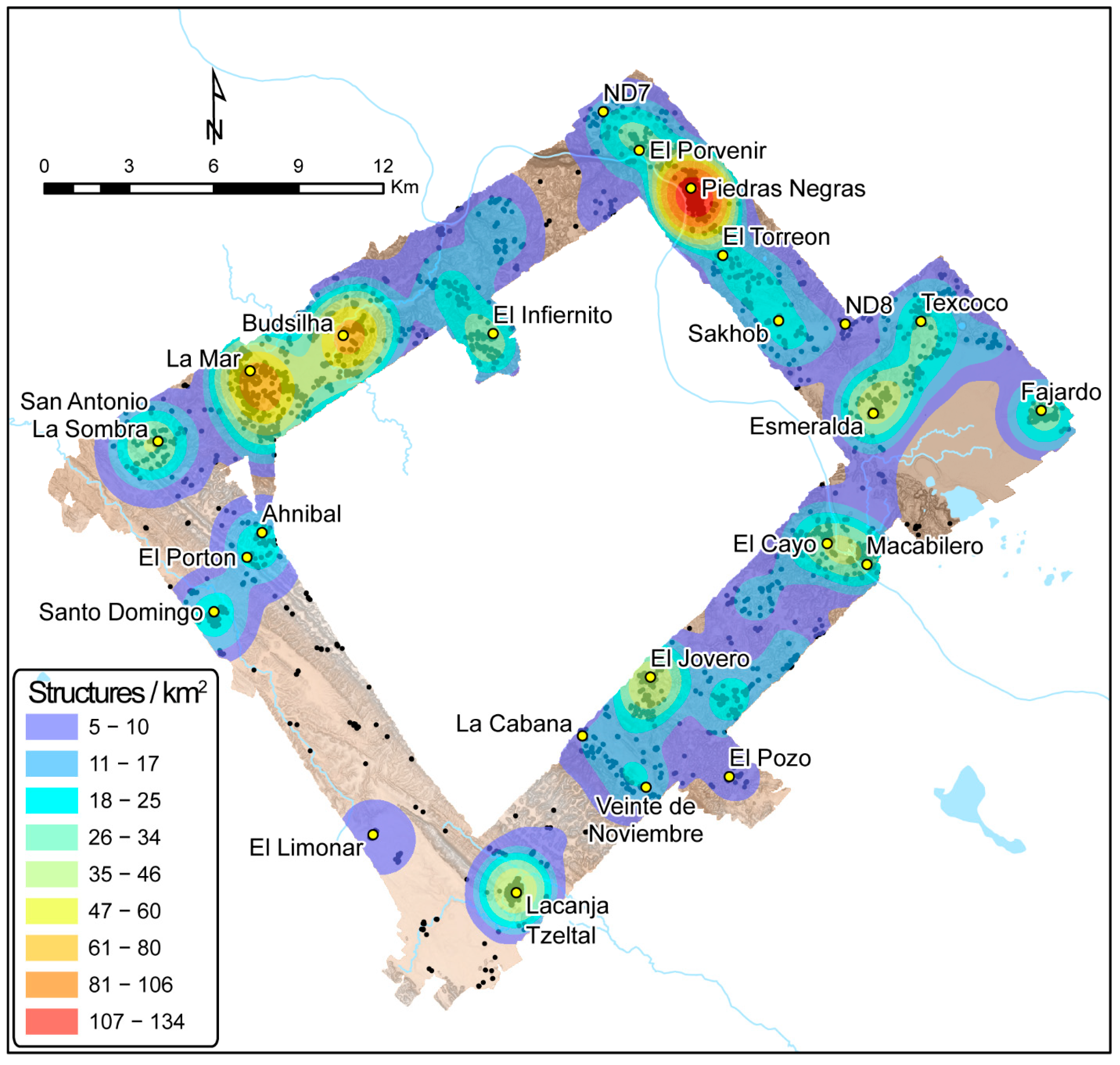
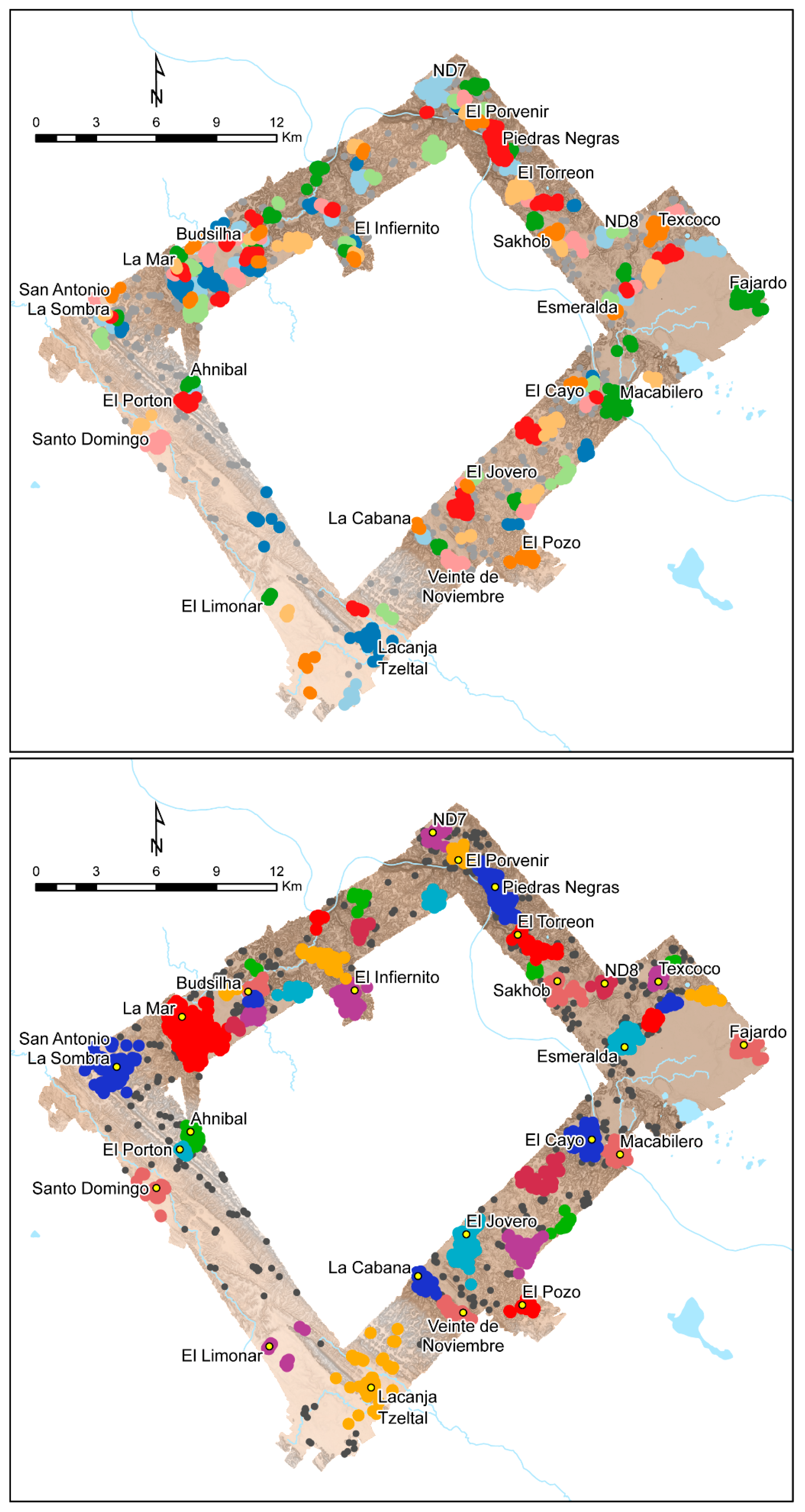
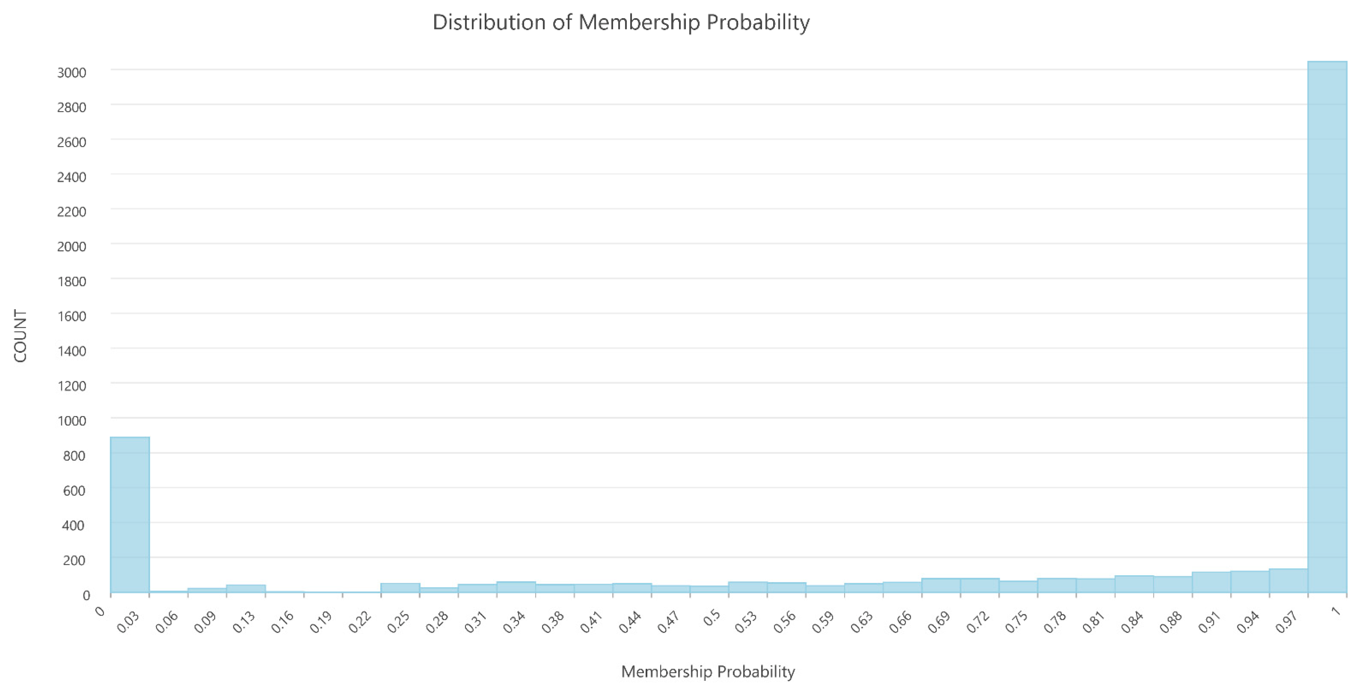
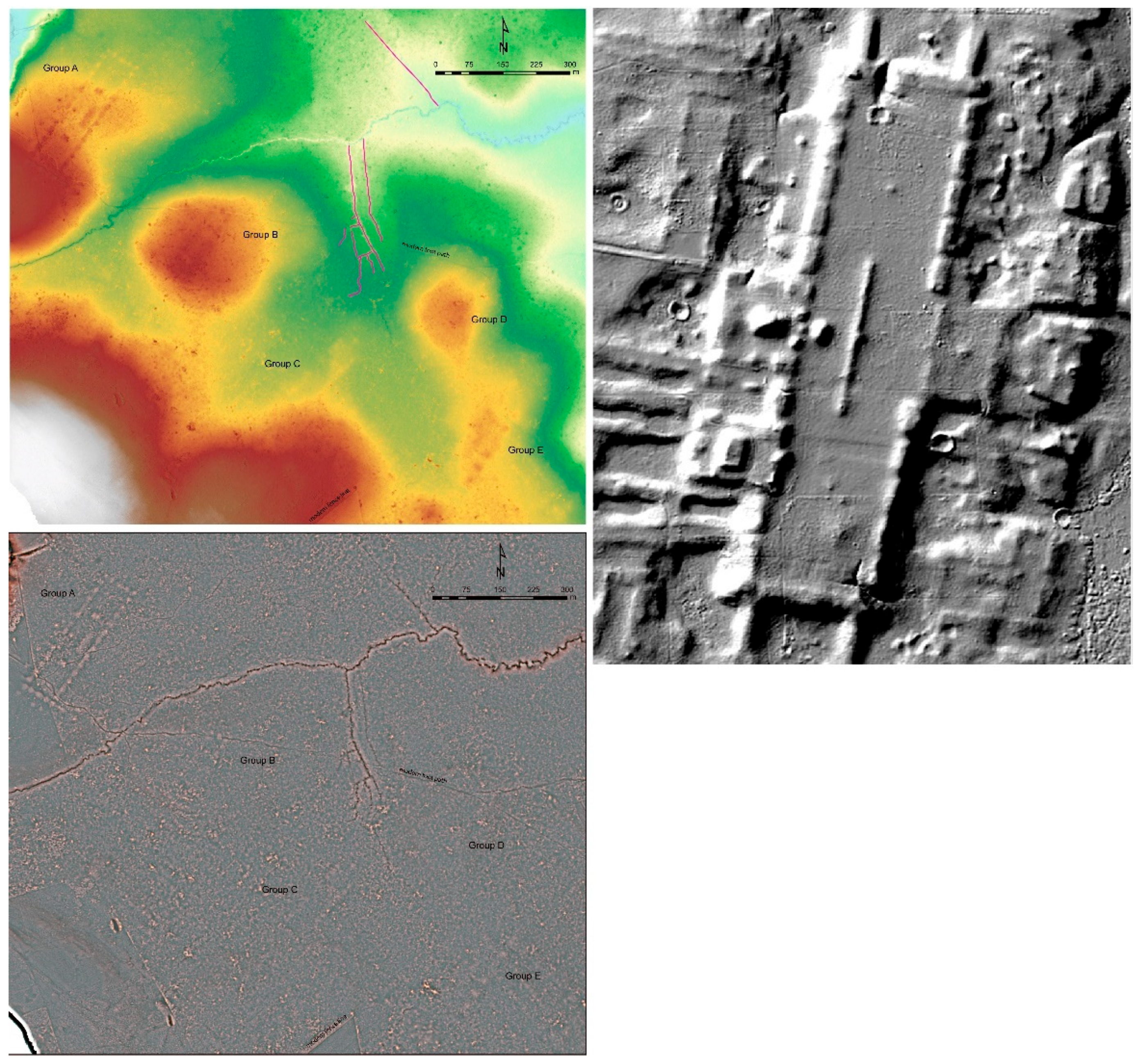
3.1. Settlement Distributions and Densities

There has been a long, lively debate among archaeologists in the Maya area concerning how best to count residential structures and from these counts extract a reasonable, synchronic model for population counts and densities in any given period e.g., [47,48,49]. A thorough engagement with these discussions is beyond the scope of this article, but a brief consideration is warranted. For some investigators, in cases where there are extensive excavations of multiple patio groups, a productive sampling technique, or when excellent preservation permits assessments of room space or roofed areas, it may be that the patio group, plazuela, or some other such grouping of structures may prove possible to correlate with the social notion of the “household” as the most useful basis for such counts [47,50].
However, with our current data set from pedestrian survey, sample excavations, and lidar analysis, it is premature to assert that any group of structures we have identified can be correlated with a household or other similar social unit. Further, many of the structures evident in our lidar data (e.g., ridgetop settlements) do not conform to formal group arrangements of patios or other discrete residential units that we can confidently identify. We therefore use the individual structure as the basic unit of analysis and the basis for population models. Using structures as the basis for our counts also provides a point of comparison with robust data and population modeling from the Central Petén [8].
For the purposes of our structure counts and settlement density analyses, lacking excavation data for most buildings, we do not distinguish between structure form or function (cf. [37]). Thus ‘structure’ includes all features that might reasonably be called ‘buildings’, from small residences to massive pyramids, ball courts, and more. We distinguish these from other identified anthropogenic features, including defensive walls, terraces, canalized fields, dams, and berms. In four transects encompassing ~331 km2, we identified 5220 structures with high confidence (1939 ground-verified), a density of ~16 str/km2 (Figure 6; Table 3). Even accounting for the distinct counting methods used by different research teams, this structure density is far lower than those derived from wide-area lidar imagery for other areas, including 29 str/km2 from the Central Petén, Guatemala [8]; 49 str/km2 from a longer but narrower transect extending from Chiapas to northern Yucatan, Mexico [9]; portions of the Puuc region of Yucatan with counts of 81 str/km2 [51]; and the Mopan River Valley of Belize with 120 str/km2 in the Xunantunich Settlement Survey [43].
There is also significant variability in settlement density within our study zone. Some of this comes from the construction of modern roadways and towns that have erased ancient settlement in Chiapas (the survey area remains in protected forest in Guatemala) and some from environmental context, as where the abundant lakes and wetlands impeded construction. Yet, there are also gaps in settlement where no impediments or erasures are evident. In the syncline valley that contains the Santo Domingo and Lacanja Rivers, which today has a few large towns, there are large expanses of unoccupied upland terrain with no overlying modern settlement. Ancient settlement within the valley is constrained to some scattered hinterland structures and the two centers of Lacanja Tzeltal and Santo Domingo.
Delimiting a polygon using the southwestern edge of the lidar survey data and the western edge of the Sierra Guiral yields a sample covering ~77 km2 with 428 structures, or 5.6 str/km2. This number overstates occupation during the Classic period as it includes El Limonar, where most structures were likely built and abandoned long before other surface-visible remains. Ancient settlement density in the Santo Domingo–Lacanjá Valley was thus more like other low-density areas of the Maya lowlands, such as the La Corona (8 structures/km2) and Yala (4 structures/km2) regions in the Petén [8]. Simply put, the Santo Domingo–Lacanjá Valley had significantly different settlement patterns and lower population pressure on resources than other areas of our lidar survey. Such wide variations within and between areas surveyed with lidar make extrapolations of total structure densities and related population numbers spanning the Maya Lowlands a ‘big data’ problem that can only be solved going forward with more robust data sharing and consistent structure-counting methods between research groups [51,52].
To better define the clustering of structures across the study area, we performed HDBSCAN (hierarchical density-based spatial clustering of applications with noise), a density-based clustering analysis [53,54,55] using ArcGIS Pro 2.7. To date, HDBSCAN has been little used in archaeological settlement studies though see, [56]; however, we find it to be a powerful tool for understanding the landscape of the Upper Usumacinta Region. HDBSCAN is built into ArcGIS Pro 2.7 and has several advantages over other clustering analyses more frequently used in archaeology, including kernel density estimation (KDE), the k-means cluster algorithm, and DBSCAN [57,58,59].
Kernel density estimation (KDE) offers a basic heat map that hints at the settlement distribution that may be useful archaeologically [60,61]. However, KDE is probabilistic, necessarily continuous (for settlement data that may be discontinuous), and does not account sufficiently for the landscape or resolve details of settlement clusters that might better inform our interpretations of spatial and functional/political differences between settlements (Figure 7) [58]. Further, unlike k-means analysis or DBSCAN, HDBSCAN does not require the user to predetermine the number of clusters or the distance threshold (‘epsilon’) around a point within a cluster, which are likely to be unknowns for a study region. It also allows for ‘noise’—points that do not group with other points—and clusters of varying density. Thus, to use modern terminology in considering settlements, it can identify settlement clusters or other point features in urban, suburban, or rural environments where individual households may be quite distant from one another (Caspari and Jendryke 2017: 182). The OPTICS (Ordering Points To Identify Cluster Structure) algorithm [62] in ArcGIS Pro 2.7 offers benefits similar to HDBSCAN, but with our data set OPTICS tended to create problematic clusters (lumping settlements we know from ground research to be spatially distinct) and reduced outliers (noise), creating overly ‘clean’ models.
Iterative runs of HDBSCAN, with minimum points in a cluster ranging from 4 to 45, yielded two preferred settings: 10 and 20 (Figure 8). A minimum number of 20 yielded the highest number of highest confidence points (3046 points clustered with confidence from 0.97–1; Figure 9 and Figure 10). Many of these clusters correlate well to settlements that have previously been designated as archaeological ‘sites’ based on ground survey. With a minimum number of 10 points, there were fewer highest confidence clustered points in general (2779 points with confidence 0.97–1), and many of the clusters generated are demonstrably too small to represent discrete and socially meaningful settlements. However, points identified with Piedras Negras, Lacanja Tzeltal, Fajardo, Santo Domingo, Macabilero, and Texcoco did form clusters with this setting. Indeed, the clusters formed for points associated with Piedras Negras and Lacanja Tzeltal essentially correlate with the previously mapped epicentral cores of those sites, and for La Mar this cluster correlates with the pyramids and other public architecture apparent in the lidar data.
The distinct patterns produced using HDBSCAN with these two settings highlight the strength of HDBSCAN for detecting clusters of different densities and can aid in the delimitation of urban, periurban, sub-urban, and rural settlements. Urban centers stand out as markedly denser than other settlements and exhibit a full suite of building forms and functions, ranging from small houses to large administrative and ritual structures including palaces, ball courts, and temple pyramids. Only Piedras Negras, La Mar, and Lacanja Tzeltal meet these criteria in our study zone. It is worth noting for comparison that Canuto and colleagues [8] distinguish between ‘urban’ and ‘urban core’ zones in their much more expansive coverage in the central Petén. In our study zone, only Piedras Negras reasonably exhibits the structure density that could fit the urban core definition from that region.
Surrounding urban centers there may be a distinct transitional settlement region that is not easily encompassed by notions of urbanity or rurality, which is often called the ‘peri-urban’ zone by scholars working in modern contexts e.g., [63,64]. Peri-urban settlement concentrates around the urban settlement, but with a distinct gap in the structure clusters between the inner urban zone and adjacent peri-urban zone. Further, peri-urban settlement lacks most obvious political and ritual structures of its own, suggesting that the ancient residents relied on urban or sub-urban settlements to provide the functions carried out in such structures.
Sub-urban settlements are small but obviously nucleated centers. Some have significant monumental architecture, and in cases like the small center of El Cayo (132 structure in 1.4 km2; 94.3 str/km2), there are inscribed stone monuments detailing a local lineage of nobles. Nonetheless, El Cayo and other similar settlement clusters distinctly lack one or more features such as large public plazas, temple-pyramids, or ball courts, found as a suite only in the three capitals [65]. In prior research, Golden, Scherer, and colleagues [1] called such settlements ‘secondary’ or ‘tertiary’ political centers; such settlements are encompassed by the ‘rural’ category defined by Canuto and colleagues [8]. Finally, we define rural settlement as the scattered structures that do not show significant clustering in association with larger settlements and lack obvious political and ritual structure forms. Rural settlement may be closer to one or another urban or sub-urban center but exhibit no evident spatial attraction to (they do not evidently cluster with) those denser settlements.
At Piedras Negras, the urban core defined by HDBSCAN, with min 10, encompasses an area that essentially replicates the previously mapped epicenter of the ruined city [46] and covers ~0.9 km2 with 600 structures, yielding a density of 659 structures per km2. However, HDBSCAN with a minimum cluster size of 20 (min 20) shows statistically significant clusters of settlement separated by intervals between 0.5 and 1 km in a series of ‘peri-urban’ settlements that extend as far as El Porvenir, ~4 km to the north, and Sakhob and ND8, ~6 km to the southeast (all within Guatemala). Taken together, this Piedras Negras sprawl encompasses 1023 structures over ~12 km2 (85.25 str/km2). Beyond Sakhob, there is a more expansive gap of more than 2 km to the southwest before reaching the edge of more distant hinterland clusters such as Esmeralda and La Pista. The peri-urban settlements surrounding Piedras Negras consist of household structures and lack public architecture (large plazas, ball courts, or temple-pyramids); public architecture is not evident until crossing the ~2 km gap southwest of Sakhob and reaching settlements such as Esmeralda and Texcoco.
The center of La Mar, encompassing that capital’s public architecture and a relatively tight cluster of residential buildings established using HDBSCAN (min 10), encompasses 97 structures in ~0.3 km2 (237 str/km2). Despite its small core, La Mar was the nexus for a sizable surrounding peri-urban settlement of 571 structures in ~5.6 km, or 101.8 str/km2, significantly denser than the peri-urban settlement associated with Piedras Negras. The rugged hills of the Sierra Guiral to the west of La Mar likely influenced the gap of more than 2 km between La Mar and the next settlement cluster at San Antonio La Sombra. To the northwest of La Mar, evident gaps between settlement clusters are small, with settlement essentially continuous as far as Budsilha, except where wetlands precluded construction. We also know from ground survey that apparent absences beneath the modern towns of Agua Cristalina and Nueva Esperanza Progresista obscure ancient settlement. To the northwest of Budsilha, settlement clusters become more widely scattered among the hills approaching the Usumacinta River.
The urban core of Lacanja Tzeltal covers an area of ~0.37 km2, as established with HDBSCAN (min 10), correlating with the previously mapped site core [17]. This is roughly the same area as the epicenter of La Mar, yet with twice as many structures (187 structures: 505.4 str/km2). Moreover, Lacanja Tzeltal has little outlying settlement despite the abundance of open terrain upon which settlement could have been expanded. The cluster defined using HDBSCAN (min 20) encompasses ~8.5 km2, within which are a mere additional 48 structures.

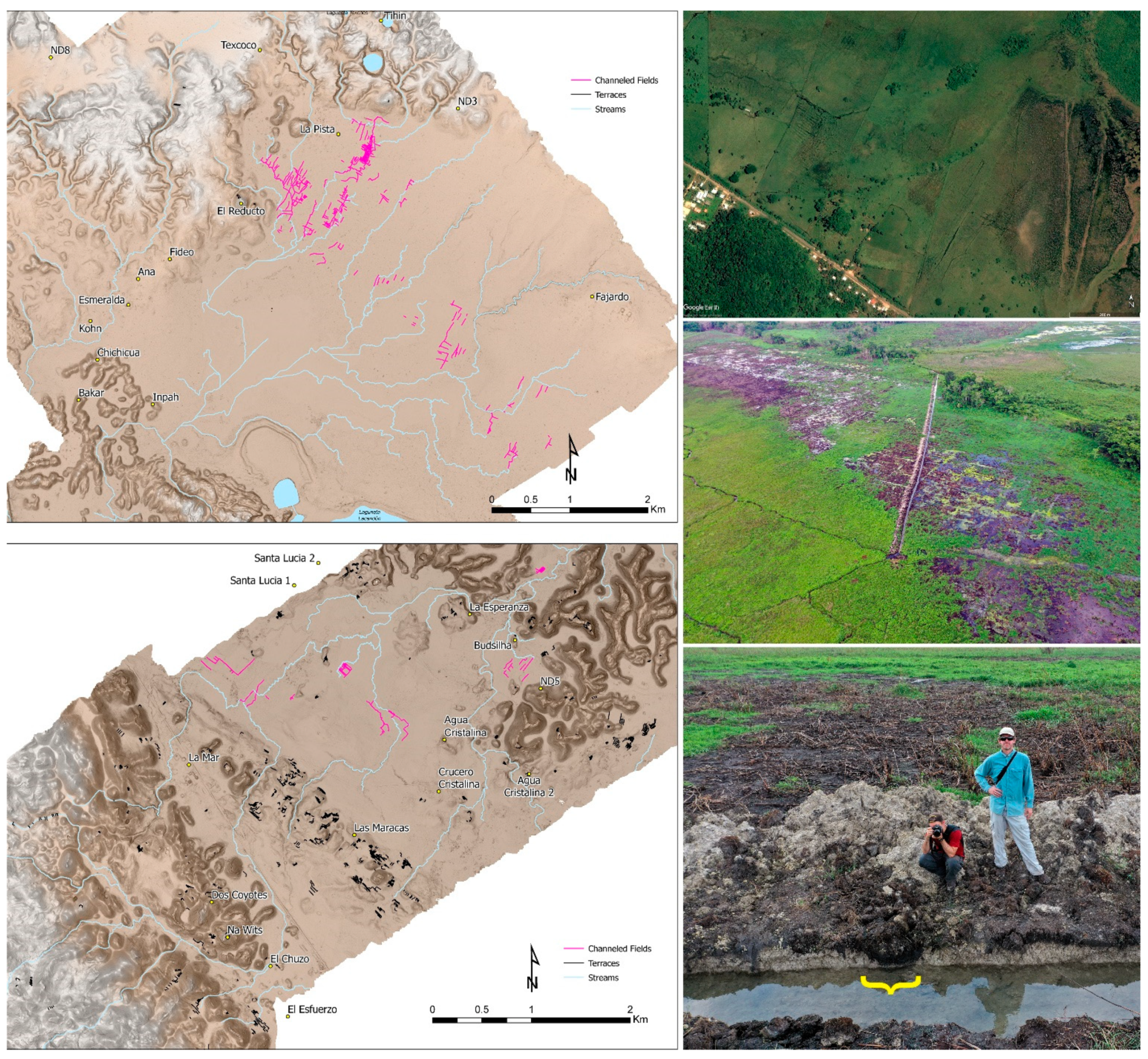
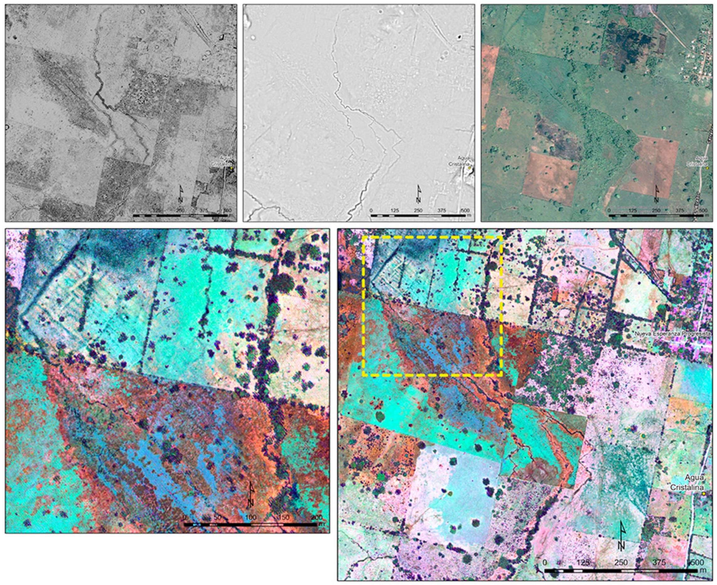
3.2. Agricultural Intensification

The extent and differential distribution of landscape modifications for agricultural infrastructure revealed by this lidar survey were striking. Canalized wetland field systems are found in expansive valley floors with slopes of less than 3° that offer drainage into the abundant stream and lake systems of the study region. There are complex groupings of orthogonal channels and fields and streams modified to create linear channels and right-angle bends. There are also shorter channels forming simple drainages evident intermittently along the banks of stream channels including the Busiljá River (Figure 11). The bare-earth DEM was the most useful lidar data product for identifying wetland fields under forest canopy. However, the Titan MW LiDAR system used for data collection also provides first-return intensity data at three wavelengths (1550, 1065, and 532 nm) from which it is possible to produce false-color rasters [38,39].
In areas of heavy canopy, where first returns tend to be from above-ground vegetation, these false-color images do not directly reveal details of the ground surface, though they may offer important indirect information about sub-canopy features [39]. Where there is no canopy, the false-color rasters produced from first return lidar intensity data do not necessarily extend our understanding of the extent of canalized field systems but do clarify details and complexities in the layout of fields not otherwise visible in the DEM’s elevation data (Figure 12).
Remarkably, the wetland channels identified in these lidar transects represent a fraction of such features within a much broader expanse visible in publicly available Google Earth imagery. The system of fields identified just east of La Mar continues intermittently no less than 9.5 km northwest in the modern community of Nuevo Canán and 13 km to the south as far as the modern community of Nuevo Francisco León. In total, the canalized field systems evident in Google Earth and lidar data in Chiapas cover an area of ~8.4 km2 running along the eastern base of the Sierra Guiral and draining into perennial streams and sinkhole lakes. Although field systems appear scattered and discontinuous, this is likely due in part to failures of data resolution and the result of erasure through natural and anthropogenic processes. Roadways and the drainage of wetlands for oil palms and cattle ranching have been particularly destructive to ancient fields in Chiapas in recent decades.
A distinct system of fields encompasses at least ~10.9 km2 near ancient settlements ringing the wetlands north of the Laguneta Lacandón in Guatemala. Without recognizing the presence of agricultural intensification, Kristofer Johnson and colleagues [66] previously sampled these fields for signatures of ancient agriculture in the form of elevated δ13C in soil organic matter (SOM), resulting from the growth of C4 plants such as maize. The highest SOM δ13C levels were found in what we can now identify as an extensive canalized field system. Through cross-comparisons with buried soil horizons near Piedras Negras, dated using radiocarbon [67], Johnson and colleagues determined that all samples SOM δ13C peaked during the Classic period and dropped dramatically following the political collapse of the 9th century AD. Small clusters of canalized fields are also associated with Lacanja Tzeltal and El Limonar (totaling ~0.5 km2) in the Santo Domingo–Lacanja Valley, as well as in the wetlands surrounding Budsilha.
To put the scale of this nearly 20 km2 total of canalized wetland field systems into inter-regional perspective, in the more densely settled areas of the Petén surveyed by the PLI, the 135 km2 region associated with Naachtun contained the greatest total area of fields at 31.5 km2, while the largest individual blocks of fields measured up to 7 km2 near the site of Holmul [8]. Analysis of 274.6 km2 of lidar data in the Rio Bravo watershed has identified 14 km2 of wetland fields, with the largest individual component measuring ~5 km2 [38].
We have yet to excavate or securely date most areas of canalized fields. However, the systems near La Mar and north of the Laguneta Lacandón are associated with settlements that we know from excavations to have had their most significant occupation from AD 600 to 900. Moreover, almost all channels in the study area follow the roughly 30° or 120° azimuth axes used for Classic period settlement in the region [1]. In June 2019, project members worked with a local landowner to make an initial assessment of fields in the modern town of Nuevo Canán. These ancient fields had been recently crosscut by a drainage ditch, revealing construction and deposition patterns remarkably similar to the well-documented fields of the Rio Bravo watershed of Belize [38,68] and in the vicinity of Palenque, Chiapas [69]. In the Rio Bravo watershed and at Palenque, canalized field systems reached their maximum expanse during the Late Classic period, though they were, in part, likely extensions and modifications of earlier systems [68]. In the study zone, too, the earliest wetland fields may be the short, simple channels associated with settlements such as El Limonar and others north of Budsilha that we provisionally date to the Preclassic period because of the geometry and organization of their structures [39,70].
Ancient farmers managed water levels in the wetland fields using dams and sluices to impound and release water as needed, revealing the profound local environmental knowledge of their builders. We offer here two examples. The first is a large dam (~33 m long × 6 m wide × 2.5 m high) built along a drainage east of La Mar and located just upstream from canalized fields. Behind the dam is a reservoir that currently measures ~450 m3 (~30 × 30 × 0.5 m). Running along the northeastern edge of the architectural core at Budsilha is a stream with an ancient dam documented in the course of fieldwork. This feature regulated water stored in a perennial wetland just east of the site and the canalized fields to the south and east of the site. We have also frequently identified small dams on streams elsewhere in the study area via lidar data and ground survey. Ancient dams and canalized fields are not maintained by current communities yet may continue to have a significant impact on modern farming. Local community collaborators report that, prior to the expansion of cattle ranching, wetlands around La Mar and Budsilha sustained agriculture through the dry season and yielded up to three harvests of maize, rice, and other crops per year.
In upland areas with a slope of less than ~14°, agricultural intensification took the form of extensive tracts of terracing. Evident in the DEM and bolstered by ground verification, these terraces sustained crops and decreased erosion from deforestation and the region’s heavy rainfall [67,71]. There are contour terraces around the sides of hills and check dams in the small dips, gullies, and valleys of the karst landscape [72]. Construction typically consists of dry laid cobbles and boulders evident on the surface [69,73], though further excavations are needed to better understand construction techniques, function, dating, and the array of crops grown there. Contour terraces and check dams are particularly abundant in the low hills just east of the Sierra Guiral, immediately to the north and east of La Mar, and around the sites of El Jovero and El Eden. They are far less frequent in areas closer to the more vertiginous, fractured landscape approaching the anticline bisected by the Usumacinta River.
Areas of similar topography in the Guatemalan portion of these lidar data exhibit only a few check dams identified from the lidar DEM and prior ground survey. Fabian Fernández and colleagues [67] suggest that, in the near vicinity of Piedras Negras, soil from back slopes was lost to erosion caused by deforestation, depositing high quality soils on foot and toe slopes. Isotopic evidence (elevated SOM δ13C) from those lower slopes points to expansive maize cultivation and deforestation without terracing during the Classic period. Some terracing has been identified via pedestrian survey on the lower hill flanks below Macabilero [15] but not elsewhere in the uplands surrounding the Laguneta Lacandón.
We thus have a striking pattern in which Piedras Negras and its surrounding peri-urban zone (from El Porvenir south to Sakhob) is devoid of agricultural intensification. Significant intensification begins no closer than ~10 km to the southeast of the core of Piedras Negras with the wetland fields north of the Laguneta Lacandón, near the small settlements of La Pista and Fajardo. To the west, there is a similar gap before reaching the agricultural terraces and wetland fields near La Mar and outlying sites including Budsilha.

4. Discussion

Our analyses support the growing body of evidence for high inter- and intraregional diversity of Classic period settlement patterns and agricultural practice [8,9,71,74,75], with critical implications for understanding the political and economic organization of ancient Maya kingdoms [1]. Inscriptions and excavations tell us that Piedras Negras was established as a dynastic center no later than AD 450, offering a refuge into which people flowed, abandoning the countryside in the aftermath of a period of violent instability [5,12]. Ceramic data from Piedras Negras and outlying settlements show that, as the urban population grew, settlements spread out after AD 600, expanding towards El Porvenir and Sakhob [1].
As settlement spread, community members gradually opened expansive swaths of foot- and toe-slope soils to agriculture without investing labor in the construction and maintenance of terraces or wetland fields [46,67]. Importantly, lidar data show that peri-urban settlements surrounding Piedras Negras lacked public architecture of their own, and there are no evident nodes of settlement around which other households clustered. Such patterns contrast markedly with urban and peri-urban landscapes at urban centers like Caracol in Belize and elsewhere in the Maya lowlands, where causeways connect the royal core to outlying political and economic settlement nodes [8,69,71,76,77]. Residents of the peri-urban fringe surrounding Piedras Negras would have sought many political, economic, and religious functions in the urban center or at smaller sub-urban settlements like Esmeralda and Fajardo provided with ball courts or public plazas but which lack one or more of the full suite of architectural accoutrements found at capital centers.
Cluster analyses using HDBSCAN enrich and help to explicate findings from excavations that allow us to date the occupation of sub-urban centers. We conclude that most sub-urban centers in the Guatemalan portion of our study were likely settled through the fissioning of households from urban and peri-urban Piedras Negras during the Late Classic period. Settlers left a demonstrable gap between the peri-urban and sub-urban settlements south of Piedras Negras; sub-urban centers then became new nodes around which settlement densified as they attracted and retained populations over the course of the Late Classic period [1]. Notably, despite its importance as the largest, most powerful urban center in the study region, and its clear centrality to settlement east of the Usumacinta River, there is little settlement clustering near Piedras Negras on the western side of the river. Perhaps the difficult terrain just across the Usumacinta from Piedras Negras discouraged settlement, or perhaps there was a sense that settling on the eastern shores of the river offered some protection against overland attacks from the west.
The k’uhul ajaw of Piedras Negras governed from an urban center lacking agricultural intensification, which contrasts markedly with a city like Caracol and surrounding areas of Belize, which are enveloped by a densely terraced landscape [71,78,79]. However, the pattern of settlement at Piedras Negras mirrors in some ways the monumental centers of the Central Petén. There, the largest and most densely settled cities similarly lacked agricultural intensification in their core settlements, leading researchers to infer that the residents of urban cores in the Central Petén depended on food production in the countryside [8,39]. However, at Piedras Negras, the urban and peri-urban residents may have been able to feed the city without intensification, with soil chemistry pointing towards maize farming of the lower toe slopes as noted above [46,67].
Nelson [46] calculated that his estimated 2600 occupants of central Piedras Negras could have been supported by arable lands within 10 km of the city, solely within modern Guatemala, without intensification. The far greater intensification of agricultural infrastructure in less densely settled regions of the study area suggests the production of significant surpluses of food and other agrarian products in these areas. This surplus would then have moved through networks of trade, taxation, and tribute, with the courts and markets of urban and sub-urban centers—and Piedras Negras the largest of these—the likely destinations for much of it see also [39,80].
In this model, at least some residents of urban and peri-urban Piedras Negras were differently engaged in the regional economy and produced different goods for consumption and exchange than their counterparts in the hinterland communities associated with intensified terraces and fields. Yet, despite the lack of evident agricultural infrastructure associated with Piedras Negras, isotopic analyses of human skeletons indicate that at the height of the kingdom, from about AD 620 to 750, the residents of that capital enjoyed among the highest maize consumption levels in the Maya world, with similar levels of maize and animal protein consumed regardless of socioeconomic status [81]. Excavations at Piedras Negras provide robust evidence of a marketplace [82,83], and we envision this was a lively place of trade in both bulk ingredients and prepared foods, much as is shown in the murals of Calakmul, where urban residents provisioned their households [84].
At La Mar, the limited presence of Early Classic ceramics in the vicinity of the urban core, and the absence of any materials from this period in outlying settlement, combined with cluster analysis, tells us that La Mar was an early focus of settlement clustering. Populations expanded gradually across the countryside over the course of the Late Classic period [16]. Outlying nodes with some components of public architecture—including Budsilha, Agua Cristalina, and San Antonio La Sombra—are found in a radius of about 4 km. Excavations at Budsilha demonstrate that the principal architecture of that site was built only after AD 600. Further, we know that Budsilha, at least, was an important economic hub and center of production for obsidian tools, likely sending these materials to market at Piedras Negras and elsewhere [82]. Yet neither Budsilha nor any other peripheral center constituted the same sort of focus for settlement clustering as La Mar.
In marked contrast to Piedras Negras, intensive agricultural infrastructure was built close to the core of royal architecture at La Mar, with terracing and wetland fields abundant and expansive. The proximity of so many fields so close to the royal center of La Mar might suggest the involvement of its court in the management of production. However, the apparent concentration of fields may result in part from our choice to sample via relatively narrow lidar transects with capital centers as nodes [51]. Canalized fields are intermittently evident in Google Earth imagery all along the wetlands to the east of the Sierra Guiral, as far away as Nuevo Canán and Nuevo Francisco León, where we have yet to identify significant ancient settlement densities or political centers despite extensive pedestrian and aerial drone lidar survey. There is also abundant terracing associated with smaller settlements without obvious public architecture, such as El Jovero. All of this suggests that more extensive lidar survey will reveal intensive agricultural infrastructure associated with settlements of all sizes and positions in the political hierarchy along this stretch of the valley.
Excavations at Lacanja Tzeltal indicate that the surface-visible masonry architecture dates to the Late Classic period and is built over Preclassic settlement comprised largely of earthen platforms [17]. The earliest known textual reference to the Sak Tz’i’ dynasty comes from a stela at Piedras Negras dated to AD 628, further supporting the understanding of dynastic Lacanja Tzeltal as a Late Classic period phenomenon [5]. By all appearances, Lacanja Tzeltal was thus an incipient urban center from the 7th through 9th centuries AD. Like many Maya royal courts, and Piedras Negras long before it, the Late Classic period boom of the urban core at Lacanja Tzeltal represented the establishment of a new dynasty, a disembedded capital [85], the growth of which was interrupted by the collapse of the 9th century. Notably, its builders established all the key architectural hallmarks of a major royal center: pyramids and other ritual structures adorned with inscriptions, plazas lined with stelae, a ball court, fortifications, and, most relevant for our discussion, relatively high settlement density. However, Lacanja Tzeltal never saw the growth of expansive surrounding settlement comparable to that of Piedras Negras or La Mar. Although there are canalized wetland fields near the architectural core Lacanja Tzeltal, the scale of that intensification is limited, matching the minimal spread of settlement [17].
We note, too, that in a region with abundant surface and subsurface water, and some of the highest levels of precipitation in the Maya Lowlands, centralized control over water storage and distribution was not a significant aspect of political practice in these three kingdoms or elsewhere in the Upper Usumacinta River region [86]. This stands in marked contrast with other areas of the Southern Maya Lowlands [8,87,88]. We find significant water storage facilities associated almost exclusively with hilltop centers that offered refuge in times of strife [15,16]. Dams used to impound and discharge water in canalized fields are scattered throughout the study region, but even where spatially associated with larger sites (as at Budsilha), these features are not labor intensive. Fields could easily have been built iteratively, by small groups, with limited organizational oversight by a political hierarchy, and we suggest that this is exactly what took place [89].

5. Conclusions

This initial lidar study in the Upper Usumacinta River valley and the application of HDBSCAN density-based cluster analysis to the structures identified has transformed our understanding of the relationships of the three royal centers of Piedras Negras, La Mar, and Lacanja Tzeltal to their surrounding settlement and the agricultural infrastructure. We also suggest that the application of HDBSCAN to settlement data in archaeological settlement studies has broader utility for scholars working in other regional contexts, given the strengths of the method for defining clusters of varying density without pre-assigning the number of clusters or minimum radius, and for its ability to define features as outliers (noise). Combining remote sensing data with our ground-based research, we have demonstrated that the three neighboring kingdoms considered in this study exhibit dramatically different patterns and histories of settlement and agricultural intensification. Thus, rather than a singular ‘low-density urbanism’ [90,91,92], we have a variety of low-density urbanisms [71] that resulted from distinct political and economic organization, settlement histories, and environmental constraints in three adjacent valleys.
Critically, the distribution of settlement and infrastructure for agricultural intensification in all three valleys suggests that the study region did not experience resource stress during the Classic Period. Further, regional population pressure was not likely the primary impetus for constructing and maintaining agricultural infrastructure. There are large areas that are sparsely settled, something that is particularly evident in the Santo Domingo–Lacanja Valley, with its large swaths of terrain devoid of ancient settlement and agricultural infrastructure. If we again use the population index advocated by Canuto and colleagues [8], the maximum Classic period population for those portions of the valley covered by these lidar transects was fewer than 3000 people, and we suspect it was far lower than that. As a simple point of comparison, as of 2020, the modern population of this valley within the lidar transect was ~8000 people, (www.inegi.org.mx/app/scitel/Default?ev=9 (accessed on 13 October 2021)) supported by maize-based agriculture and cattle ranching.
Moreover, the striking lack of agricultural intensification within a 10 km radius of Piedras Negras strongly suggests that there was no perceived need for such capital investments in the landscape. Maize, and likely a host of other crops, were grown and consumed there in abundance [67,81], but residents made a choice not to terrace. While there are no wetlands ideal for canalized fields between Esmeralda and Piedras Negras, there are abundant hills in the urban and peri-urban zones of Piedras Negras suitable for terracing (i.e., slope < 14°). Even where communities did invest in wetland fields around the Laguneta Lacandón, there was no significant investment in terracing.
Barring evidence of population pressure on agrarian resources [75], we suggest instead several not mutually exclusive hypotheses that must be tested in future research. First, the residents of settlements lacking terraces and wetland fields were engaged in agroforestry or the production of non-agricultural goods that did not require such infrastructure. In this case, economic activities were more evenly distributed on the landscape, with only some forms of agriculture detectable with remote sensing. Second, agricultural intensification around the Laguna Lacandón and across expansive areas closer to La Mar reflect growing demands of taxation and tribute from royal courts and hinterland nobles over the course of the Classic period. That demand may have increased significantly when Piedras Negras pulled La Mar into its political orbit by the 8th century AD [2,75,93]. Third, intensive agriculture provided goods for marketing, including long-distance trade. In the 16th and 17th centuries AD, when regional populations were likely far lower than the Classic period, southeastern Chiapas was known for its production of annatto, vanilla, and cacao, which were traded from Yucatan to the highlands of Guatemala [94]. Fourth, infrastructure represented an investment in risk reduction, permitting the retention of soil moisture during periods of drought and the production of agriculture surpluses that buffered communities against crop loss from warfare and climate instability [5,75,86]. Overall, the extent and abundance of intensified agricultural infrastructure in the study zone is surprising, considering the relatively low population densities. In comparison to other parts of the Maya lowlands, the region’s population levels are among the lowest, while its investment in agricultural intensification is relatively high e.g., [8,9,43,51,71].
Finally, while recognizing modern economic factors, including international trade, local markets, and land ownership and usufruct practices are distinctly different from their pre-Hispanic counterparts, we nonetheless argue that more detailed and complete knowledge of ancient landscape transformations can inform practices of land use today. The scale of intensification and the presence of some canalized fields in association with sites like El Limonar, almost certainly occupied by 800 BC or earlier, highlights questions put forward by researchers in the wetland fields of Belize concerning the impact of such practices on the dynamics and timing of the advent of the Anthropocene [68]. The enduring impact of landscape capital like terraces and wetland fields may also continue to influence modern land use in the many communities founded in the study region during the final decades of the 20th century. Omar Alcover Firpi [15] identified the forested wetlands north of the Laguneta Lacandón, with their relict fields, as one of the healthiest and ecologically diverse areas of the study zone. In Chiapas, local descriptions of three yearly crops in what we now know to be ancient canalized fields speak to their potential for continuing productivity and potential as a buffer against frequent modern droughts [86]. Many of these wetlands, however, are being drained and given over to cattle ranching and oil palm plantations. These activities are pushing contemporary subsistence farmers to burn and sow unterraced hillslopes with gradients much steeper than the toe and foot slopes used by ancient farmers [67]. Future work on ancient and modern soil loss in the region should be able to clarify whether maize-based agriculture, ranching, or palm plantations are sustainable in the region over the long term.

Author Contributions

Conceptualization, C.G. and A.K.S.; methodology, C.G., A.K.S. and W.S.; formal analysis, C.G., A.K.S., W.S., O.A.F., M.A., A.B., M.C., G.V.K.III, M.M., A.R.R., J.S. and B.W.; investigation C.G., A.K.S., W.S., T.M., S.M.-H., J.C.F.D., S.d.P.J.Á., O.A.F., G.V.K.III, M.M., A.R.R. and J.S.; writing—original draft preparation, C.G. and A.K.S.; writing—review and editing, C.G. and A.K.S.; project administration, C.G. and A.K.S.; funding acquisition, C.G., A.K.S., T.M., and S.M.-H. All authors have read and agreed to the published version of the manuscript.

Funding

This research was funded by by the Alphawood Foundation of Chicago, the National Science Foundation (BCS-1917671, and BCS-1849921), the Social Sciences and Humanities Research Council of Canada (435-2019-0837), Brandeis University (Provost’s Research Fund, Norman Fund, Latin Caribbean, and Latinx Studies program), Brown University (Salomon Faculty Research Award), and McMaster University (Arts Research Board and Faculty of Social Sciences).

Institutional Review Board Statement

Not applicable.

Informed Consent Statement

Not applicable.

Data Availability Statement

The lidar data presented here are freely available for research purposes to scholars for collaboration, with the permission of the appropriate Mexican or Guatemalan authorities.

Acknowledgments

This research was conducted with the permission of the Instituto Nacional de Antropología e Historia (INAH, Mexico) and the Instituto de Antropología e Historia (IDAEH, Guatemala), as well as local communities in Guatemala and Mexico. We also thank Thomas Pingel and Takeshi Inomata for their generous advice on raster visualizations, and Saúl Ascencio Bocanegra, Atasta Flores Esquivel, Felix Kupprat, and Verónica A. Vázquez López for their keen observations on the ground.

Conflicts of Interest

The authors declare no conflict of interest. The funders had no role in the design of the study; in the collection, analyses, or interpretation of data; in the writing of the manuscript, or in the decision to publish the results.

References

  1. Golden, C.; Scherer, A.K.; Muñoz, A.R.; Vásquez, R. Piedras Negras and Yaxchilan: Divergent Political Trajectories in Adjacent Maya Polities. Lat. Am. Antiq. 2008, 19, 249–274. [Google Scholar] [CrossRef]
  2. Golden, C.; Scherer, A.K. Territory, Trust, Growth and Collapse in Classic Period Maya Kingdoms. Curr. Anthropol. 2013, 54, 397–435. [Google Scholar] [CrossRef]
  3. Golden, C.; Scherer, A.K. Landscapes of Warfare, Détente, and Trade in the Maya West. In Monumental Landscapes: How the Maya Shaped Their World; Houk, B., Powis, T., Arroyo, B., Eds.; University of Florida Press: Gainesville, FL, USA, 2020; pp. 218–241. [Google Scholar]
  4. Scherer, A.K.; Golden, C. Revisiting Maler’s Usumacinta: Recent Archaeological Investigation in Chiapas, Mexico. Precolumbia Mesoweb Monographs; Precolumbia Mesoweb Press: San Francisco, CA, USA, 2012; Volume 1, 86p. [Google Scholar]
  5. Martin, S. Ancient Maya Politics: A Political Anthropology of the Classic Period 150—900 CE; Cambridge University Press: New York, NY, USA, 2020. [Google Scholar]
  6. Martin, S.; Grube, N. Chronicle of the Maya Kings and Queens: Deciphering the Dynasties of the Ancient Maya, 2nd ed.; Thames and Hudson: New York, NY, USA, 2008. [Google Scholar]
  7. Chase, A.F.; Chase, D.Z.; Weishampel, J.F.; Drake, J.B.; Shrestha, R.L.; Slatton, K.C.; Awe, J.J.; Carter, W.E. Airborne LiDAR, Archaeology, and the Ancient Maya Landscape at Caracol, Belize. J. Archaeol. Sci. 2011, 38, 387–398. [Google Scholar] [CrossRef]
  8. Canuto, M.A.; Estrada-Belli, F.; Garrison, T.G.; Houston, S.D.; Acuña, M.J.; Kováč, M.; Marken, D.; Nondédéo, P.; Auld-Thomas, L.; Castanet, C.; et al. Ancient Lowland Maya Complexity as Revealed by Airborne Laser Scanning of Northern Guatemala. Science 2018, 361, eaau0137. [Google Scholar] [CrossRef] [PubMed] [Green Version]
  9. Schroder, W.; Murtha, T.; Golden, C.; Anaya Hernández, A.; Scherer, A.; Morell-Hart, S.; Almeyda Zambrano, A.; Broadbent, E.; Brown, M. The Lowland Maya Settlement Landscape: Environmental LiDAR and Ecology. J. Archaeol. Sci. Rep. 2020, 33, 102543. [Google Scholar] [CrossRef]
  10. Chase, A.S.Z.; Chase, D.Z.; Chase, A.F. LiDAR for Archaeological Research and the Study of Historical Landscapes. In Sensing the Past; Masini, N., Soldovieri, F., Eds.; Springer International Publishing: Cham, Switzerland, 2017; Volume 16, pp. 89–100. [Google Scholar]
  11. Inomata, T.; Triadan, D.; Vázquez López, V.A.; Fernandez-Diaz, J.C.; Omori, T.; Méndez Bauer, M.B.; García Hernández, M.; Beach, T.; Cagnato, C.; Aoyama, K.; et al. Monumental Architecture at Aguada Fénix and the Rise of Maya Civilization. Nature 2020, 582, 530–533. [Google Scholar] [CrossRef] [PubMed]
  12. Houston, S.D.; Escobedo, H.; Child, M.; Golden, C.; Muñoz, R. The Moral Community: Maya Settlement Transformation at Piedras Negras, Guatemala. In The Social Construction of Ancient Cities; Smith, M.L., Ed.; Smithsonian Institution Press: Washington, DC, USA, 2003; pp. 212–253. [Google Scholar]
  13. Muñoz, A.R. Power, Practice, and Production: Technological Change in the Late Classic Ceramics of Piedras Negras, Guatemala. Ph.D. Thesis, Department of Anthropology, University of Arizona, Tucson, AZ, USA, 2006. [Google Scholar]
  14. Scherer, A.K.; Golden, C. War in the West: History, Landscape, and Classic Maya Conflict. In Embattled Bodies, Embattled Places: War in Precolumbian Mesoamerica and the Andes; Scherer, A.K., Verano, J., Eds.; Dumbarton Oaks: Washington, DC, USA, 2014; pp. 57–87. [Google Scholar]
  15. Alcover Firpi, O. Conflict, Defense, and Cooperation at Macabilero, Peten, Guatemala. Ph.D. Thesis, Department of Anthropology, Brown University, Providence, RI, USA, 2020. [Google Scholar]
  16. Schroder, W. Cycles of Defence on the Piedras Negras Kingdom Periphery: Landscape Patrimony at the Fortified Hilltop Community of El Infiernito, Chiapas. Landsc. Res. 2021, 46, 1–18. [Google Scholar] [CrossRef]
  17. Golden, C.; Scherer, A.K.; Houston, S.; Schroder, W.; Morell-Hart, S.; Jiménez Álvarez, S.d.P.; Kollias, G.V.; Talavera, M.Y.R.; Matsumoto, M.; Dobereiner, J.; et al. Centering the Classic Maya Kingdom of Sak Tz‘i’. J. Field Archaeol. 2020, 45, 67–85. [Google Scholar] [CrossRef] [Green Version]
  18. Jackson, S.E. Politics of the Maya Court: Hierarchy and Change in the Late Classic Period; University of Oklahoma Press: Norman, OK, USA, 2013. [Google Scholar]
  19. Zender, M.U. A Study of Classic Maya Priesthood. Ph.D. Thesis, Department of Anthropology, University of Calgary, Calgary, AB, Canada, 2004. [Google Scholar]
  20. Houston, S.D. Pehk and ‘Parliaments’. Maya Decipherment: Ideas on Ancient Maya Writing and Iconography. Available online: https://decipherment.wordpress.com/2014/10/07/pehkand-parliaments/ (accessed on 19 March 2020).
  21. Golden, C.; Scherer, A.K.; Kingsley, M.; Houston, S.; Escobedo, H. The Life and Afterlife of the Classic Period Piedras Negras Kingdom. In Ritual, Violence, and the Fall of the Classic Maya Kings; Iannone, G., Houk, B.A., Schwake, S.A., Eds.; University Press of Florida: Talahassee, FL, USA, 2016; pp. 108–133. [Google Scholar]
  22. Evans, D. Airborne Laser Scanning as a Method for Exploring Long-Term Socio-Ecological Dynamics in Cambodia. J. Archaeol. Sci. 2016, 74, 164–175. [Google Scholar] [CrossRef] [Green Version]
  23. Štular, B.; Eichert, S.; Lozić, E. Airborne LiDAR Point Cloud Processing for Archaeology. Pipeline and QGIS Toolbox. Remote Sens. 2021, 13, 3225. [Google Scholar] [CrossRef]
  24. Štular, B.; Lozić, E.; Eichert, S. Airborne LiDAR-Derived Digital Elevation Model for Archaeology. Remote Sens. 2021, 13, 1855. [Google Scholar] [CrossRef]
  25. Fernandez-Diaz, J.C.; Carter, W.E.; Shrestha, R.L.; Glennie, C. Now You See It… Now You Don’t: Understanding Airborne Mapping LiDAR Collection and Data Product Generation for Archaeological Research in Mesoamerica. Remote Sens. 2014, 6, 9951–10001. [Google Scholar] [CrossRef] [Green Version]
  26. Fernandez-Diaz, J.C.; Carter, W.E.; Glennie, C.; Shrestha, R.L.; Pan, Z.; Ekhtari, N.; Singhania, A.; Hauser, D.; Sartori, M. Capability Assessment and Performance Metrics for the Titan Multispectral Mapping Lidar. Remote Sens. 2016, 8, 936. [Google Scholar] [CrossRef] [Green Version]
  27. Aliphat Fernández, M.M. Classic Maya Landscape in the Upper Usumacinta River Valley. Ph.D. Thesis, Department of Anthropology, University of Calgary, Calgary, AB, Canada, 1994. [Google Scholar]
  28. Aliphat Fernández, M.M. Arqueología y Paisajes del Alto Usumacinta. Arqueol. Mex. 1996, 4, 24–29. [Google Scholar]
  29. Štular, B.; Lozić, E. Comparison of Filters for Archaeology-Specific Ground Extraction from Airborne LiDAR Point Clouds. Remote Sens. 2020, 12, 3025. [Google Scholar] [CrossRef]
  30. Lozić, E.; Štular, B. Documentation of Archaeology-Specific Workflow for Airborne LiDAR Data Processing. Geosciences 2021, 11, 26. [Google Scholar] [CrossRef]
  31. Grammer, B.; Draganits, E.; Gretscher, M.; Muss, U. LiDAR Guided Archaeological Survey of a Mediterranean Landscape: Lessons from the Ancient Greek Polis of Kolophon (Ionia, Western Anatolia). Archaeol. Prospect. 2017, 24, 311–333. [Google Scholar] [CrossRef] [Green Version]
  32. Štular, B.; Kokalj, Ž.; Oštir, K.; Nuninger, L. Visualization of Lidar-Derived Relief Models for Detection of Archaeological Features. J. Archaeol. Sci. 2012, 39, 3354–3360. [Google Scholar] [CrossRef]
  33. Kokalj, Ž.; Zakšek, K.; Oštir, K. Visualizations of Lidar Derived Relief Models. In Interpreting Archaeological Topography: Airborne Laser Scanning, 3D Data and Ground Observation; Opitz, R.S., Cowley, D.C., Eds.; Oxbow Books: Oxford, UK; London, UK, 2013; pp. 100–114. [Google Scholar]
  34. Pingel, T.J.; Clarke, K.; Ford, A. Bonemapping: A LiDAR Processing and Visualization Technique in Support of Archaeology under the Canopy. Cartogr. Geogr. Inf. Sci. 2015, 42, 18–26. [Google Scholar] [CrossRef]
  35. Chiba, T.; Kaneta, S.-I.; Suzuki, Y. Red Relief Image Map: New Visualization Method for Three Dimensional Data. Int. Arch. Photogramm. Remote. Sens. Spat. Inf. Sci. 2008, 37, 1071–1076. [Google Scholar]
  36. Kokalj, Ž.; Hesse, R. Airborne Laser Scanning Raster Data Visualization: A Guide to Good Practice; Založba ZRC: Ljubljana, Slovenia, 2017. [Google Scholar]
  37. Thompson, A.E. Detecting Classic Maya Settlements with Lidar-Derived Relief Visualizations. Remote Sens. 2020, 12, 2838. [Google Scholar] [CrossRef]
  38. Beach, T.; Luzzadder-Beach, S.; Krause, S.; Guderjan, T.; Valdez, F.; Fernandez-Diaz, J.C.; Eshleman, S.; Doyle, C. Ancient Maya Wetland Fields Revealed under Tropical Forest Canopy from Laser Scanning and Multiproxy Evidence. Proc. Natl. Acad. Sci. USA 2019, 116, 21469–21477. [Google Scholar] [CrossRef] [Green Version]
  39. Garrison, T.G.; Houston, S.; Alcover Firpi, O. Recentering the Rural: Lidar and Articulated Landscapes among the Maya. J. Anthropol. Archaeol. 2019, 53, 133–146. [Google Scholar] [CrossRef]
  40. Horn, S.W.; Ford, A. Beyond the Magic Wand: Methodological Developments and Results from Integrated Lidar Survey at the Ancient Maya Center El Pilar. STAR Sci. Technol. Archaeol. Res. 2019, 5, 1–15. [Google Scholar] [CrossRef] [Green Version]
  41. Reese-Taylor, K.; Hernández, A.A.; Esquivel, F.A.F.; Monteleone, K.; Uriarte, A.; Carr, C.; Acuña, H.G.; Fernandez-Diaz, J.C.; Peuramaki-Brown, M.; Dunning, N. Boots on the Ground at Yaxnohcah: Ground-Truthing LiDAR in a Complex Tropical Landscape. Adv. Archaeol. Pract. 2016, 4, 314–338. [Google Scholar] [CrossRef]
  42. Inomata, T.; Pinzón, F.; Ranchos, J.L.; Haraguchi, T.; Nasu, H.; Fernandez-Diaz, J.C.; Aoyama, K.; Yonenobu, H. Archaeological Application of Airborne LiDAR with Object-Based Vegetation Classification and Visualization Techniques at the Lowland Maya Site of Ceibal, Guatemala. Remote Sens. 2017, 9, 563. [Google Scholar] [CrossRef] [Green Version]
  43. Cap, B.; Yaeger, J.; Brown, M.K. Fidelity Tests of Lidar Data for the Detection of Ancient Maya Settlement in the Upper Belize River Valley, Belize. Res. Rep. Belizean Archaeol. 2018, 15, 39–51. [Google Scholar]
  44. Webster, D.; Kirker, J. Arqueología del Paisaje: Transecto entre Piedras Negras y El Porvenir. In Proyecto Arqueologico Piedras Negras: Informe Preliminar No. 1, Primera Temporada 1997; Escobedo, H.L., Houston, S.D., Eds.; Proyecto Arqueológico Piedras Negras: Guatemala City, Guatemala, 1997; pp. 185–206. [Google Scholar]
  45. Houston, S.D.; Escobedo, H.; Forsyth, D.; Hardin, P.; Webster, D.L.; Wright, L.E. On the River of Ruins: Explorations at Piedras Negras, Guatemala, 1997. Mexicon 1998, 20, 16–21. [Google Scholar]
  46. Nelson, Z. Urban. Development at Piedras Negras, Guatemala: Agriculture, Population, and Settlement; VDM Verlag Dr. Müller: Saarbrücken, Germany, 2006; 572p. [Google Scholar]
  47. Ashmore, W.A. Some Issues of Method and Theory in Lowland Maya Settlement Archaeology. In Lowland Maya Settlement Patterns; Ashmore, W.A., Ed.; University of New Mexico Press: Albuquerque, NM, USA, 1981; pp. 37–69. [Google Scholar]
  48. Ashmore, W.A.; Willey, G.R. A Historical Introduction to the Study of Lowland Maya Settlement Patterns. In Lowland Maya Settlement Patterns; Ashmore, W., Ed.; University of New Mexico: Albuquerque, NM, USA, 1981; pp. 3–18. [Google Scholar]
  49. Rice, D.S.; Culbert, T.P. Historical Contexts for Population Reconstruction in the Maya Lowlands. In Precolumbian Population History in the Maya Lowlands; Culbert, T.P., Rice, D.S., Eds.; University of New Mexico Press: Albuquerque, NM, USA, 1990; pp. 1–36. [Google Scholar]
  50. Ashmore, W.A. Ode to a Dragline: Demographic Reconstructions at Classic Quirigua. In Precolumbian Population History in the Maya Lowlands; Culbert, T.P., Rice, D.S., Eds.; University of New Mexico Press: Albuquerque, NM, USA, 1990; pp. 63–82. [Google Scholar]
  51. Ringle, W.M.; Gallareta Negrón, T.; May Ciau, R.; Seligson, K.E.; Fernandez-Diaz, J.C.; Ortegón Zapata, D. Lidar Survey of Ancient Maya Settlement in the Puuc Region of Yucatan, Mexico. PLoS ONE 2021, 16, e0249314. [Google Scholar] [CrossRef]
  52. VanValkenburgh, P.; Dufton, J.A. Big Archaeology: Horizons and Blindspots. J. Field Archaeol. 2020, 45, S1–S7. [Google Scholar] [CrossRef] [Green Version]
  53. McInnes, L.; Healy, J.; Astels, S. hdbscan: Hierarchical Density Based Clustering. J. Open Source Softw. 2017, 2, 1–2. [Google Scholar] [CrossRef]
  54. Campello, R.J.G.B.; Moulavi, D.; Sander, J. Density-Based Clustering Based on Hierarchical Density Estimates; Springer: Berlin/Heidelberg, Germany, 2013; pp. 160–172. [Google Scholar]
  55. Campello, R.J.G.B.; Moulavi, D.; Zimek, A.; Sander, J. Hierarchical Density Estimates for Data Clustering, Visualization, and Outlier Detection. ACM Trans. Knowl. Discov. Data 2015, 10, 1–51. [Google Scholar] [CrossRef]
  56. Braymer-Hayes, K.E. A Spatial Analysis of Ceramics in Northwestern Alaska: Studying Pre-Contact Gendered Use of Space. Master’s Thesis, Department of Anthropology, Portland State University, Portland, OR, USA, 2018. [Google Scholar]
  57. Caspari, G.; Jendryke, M. Archsphere—A Cluster Algorithm for Archaeological Applications. J. Archaeol. Sci. Rep. 2017, 14, 181–188. [Google Scholar] [CrossRef]
  58. Ducke, B. Spatial Cluster Detection in Archaeology: Current Theory and Practice. In Mathematics and Archaeology; Barcelo, J.A., Bodanovic, I., Eds.; CRC Press: Boca Raton, FL, USA, 2015; pp. 366–382. [Google Scholar]
  59. Ester, M.; Kriegel, H.-P.; Sander, J.; Xu, X. A Density-Based Algorithm for Discovering Clusters in Large Spatial Databases with Noise. In Proceedings of the Second International Conference on Knowledge Discovery and Data Mining (KDD-96), Portland, OR, USA, 2–4 August 1996; Volume 96, pp. 226–231. [Google Scholar]
  60. Bonnier, A.; Finné, M.; Weiberg, E. Examining Land-Use through GIS-Based Kernel Density Estimation: A Re-Evaluation of Legacy Data from the Berbati-Limnes Survey. J. Field Archaeol. 2019, 44, 70–83. [Google Scholar] [CrossRef] [Green Version]
  61. Baxter, M.J.; Beardah, C.C.; Wright, R.V. Some Archaeological Applications of Kernel Density Estimates. J. Archaeol. Sci. 1997, 24, 347–354. [Google Scholar] [CrossRef]
  62. Ankerst, M.; Breunig, M.M.; Kriegel, H.-P.; Sander, J. OPTICS: Ordering Points to Identify the Clustering Structure. SIGMOD Rec. 1999, 28, 49–60. [Google Scholar] [CrossRef]
  63. Amirinejad, G.; Donehue, P.; Baker, D. Ambiguity at the Peri-Urban Interface in Australia. Land Use Policy 2018, 78, 472–480. [Google Scholar] [CrossRef]
  64. Simon, D. Urban Environments: Issues on the Peri-Urban Fringe. Annu. Rev. Environ. Resour. 2008, 33, 167–185. [Google Scholar] [CrossRef]
  65. Inomata, T. Plazas, Performers, and Spectators: Political Theaters of the Classic Maya. Curr. Anthropol. 2006, 47, 805–842. [Google Scholar] [CrossRef]
  66. Johnson, K.D.; Terry, R.E.; Jackson, M.W.; Golden, C. Ancient Soil Resources of the Usumacinta River Region, Guatemala. J. Archaeol. Sci. 2007, 34, 1117–1129. [Google Scholar] [CrossRef]
  67. Fernández, F.G.; Johnson, K.D.; Terry, R.E.; Nelson, S.D.; Webster, D.L. Soil Resources of the Ancient Maya at Piedras Negras, Guatemala. Soil Sci. Soc. Am. J. 2005, 69, 2020–2032. [Google Scholar] [CrossRef]
  68. Krause, S.; Beach, T.P.; Luzzadder-Beach, S.; Cook, D.; Bozarth, S.R.; Valdez, F., Jr.; Guderjan, T.H. Tropical Wetland Persistence through the Anthropocene: Multiproxy reconstruction of environmental change in a Maya agroecosystem. Anthropocene 2021, 34, 100284. [Google Scholar] [CrossRef]
  69. Liendo Stuardo, R. La Organización de la Producción Agrícola en un Centro Maya Clásico: Patrón de Asentamiento en la Región de Palenque, Chiapas, México; Instituto de Antropología e Historia and the University of Pittsburgh: Mexico City, Mexico, 2002. [Google Scholar]
  70. Yaeger, J.; Brown, M.K.; Cap, B. Locating and Dating Sites Using Lidar Survey in a Mosaic Landscape in Western Belize. Adv. Archaeol. Pract. 2016, 4, 339–356. [Google Scholar] [CrossRef]
  71. Chase, A.F.; Chase, D.Z. The Ancient Maya City: Anthropogenic Landscapes, Settlement Archaeology, and Caracol, Belize. In Research Reports in Belizean Archaeology; Morris, J., Betty, S., Thompson, G., Eds.; National Institute of Culture and History: Belmopan, Belize, 2016; Volume 13, pp. 3–14. [Google Scholar]
  72. Beach, T.; Dunning, N.P. Ancient Maya Terracing and Modern Conservation in the Peten Rain Forest of Guatemala. J. Soil Water Conserv. 1995, 50, 138–145. [Google Scholar]
  73. Lobato, R. Terrazas Prehispánicas en la Región del Río Usumacinta y su Importancia en la Agricultura Maya. Estud. De Cult. Maya 1988, 17, 19–58. [Google Scholar]
  74. Fedick, S.L. The Managed Mosaic: Ancient Maya Agriculture and Resource Use; University of Utah Press: Salt Lake City, UT, USA, 1996. [Google Scholar]
  75. Turner, B.L.; Sabloff, J.A. Classic Period collapse of the Central Maya Lowlands: Insights about human–environment relationships for sustainability. Proc. Natl. Acad. Sci. USA 2012, 109, 13908–13914. [Google Scholar] [CrossRef] [Green Version]
  76. Hutson, S.R.; Welch, J.A. Roadwork: Long-Distance Causeways at Uci, Yucatan, Mexico. Lat. Am. Antiq. 2021, 32, 1–21. [Google Scholar] [CrossRef]
  77. Stanton, T.W.; Ardren, T.; Barth, N.C.; Fernandez-Diaz, J.C.; Rohrer, P.; Meyer, D.; Miller, S.J.; Magnoni, A.; Pérez, M. ‘Structure’ Density, Area, and Volume as Complementary Tools to Understand Maya Settlement: An Analysis of Lidar Data along the Great Road between Coba and Yaxuna. J. Archaeol. Sci. Rep. 2020, 29, 102178. [Google Scholar] [CrossRef]
  78. Chase, A.S.Z.; Weishampel, J. Using Lidar and GIS to Investigate Water and Soil Management in the Agricultural Terracing at Caracol, Belize. Adv. Archaeol. Pract. 2016, 4, 357–370. [Google Scholar] [CrossRef]
  79. Macrae, S.; Iannone, G. Understanding Ancient Maya Agricultural Terrace Systems through Lidar and Hydrological Mapping. Adv. Archaeol. Pract. 2016, 4, 371–392. [Google Scholar] [CrossRef] [Green Version]
  80. Harrison-Buck, E.; Willis, M.D.; Walker, C.P.; Murata, S.; Burg, M.B.; Chase, A.F.; Chase, D.Z. From Urban Core to Vacant Terrain Defining the Heterotopia of Maya Monumental Landscapes at the Crossroads of the Middle Belize River Valley. In Approaches to Monumental Landscapes of the Ancient Maya, 1st ed.; Houk, B.A., Arroyo, B., Powis, T.G., Eds.; University Press of Florida: Gainesville, FL, USA, 2020; pp. 85–108. [Google Scholar]
  81. Scherer, A.K.; Wright, L.E.; Yoder, C.J. Bioarchaeological Evidence for Social and Temporal Differences in Subsistence at Piedras Negras, Guatemala. Lat. Am. Antiq. 2007, 18, 85–104. [Google Scholar] [CrossRef]
  82. Roche Recinos, A. Regional Production and Exchange of Stone Tools in the Maya Polity of Piedras Negras, Guatemala. Ph.D. Thesis, Department of Anthropology, Brown University, Providence, RI, USA, 2021. [Google Scholar]
  83. Golden, C.; Scherer, A.K.; Schroder, W.; Vella, C.; Roche Recinos, A. Decentralizing the Economies of the Maya West. In Nuts and Bolts of the Real “Business” of Ancient Maya Exchange; Masson, M.A., Freidel, D.A., Demarest, A.A., Eds.; University Press of Florida, Tallahassee: Gainesville, FL, USA, 2020; pp. 403–433. [Google Scholar]
  84. Carrasco Vargas, R.; Baqueiro, M.C. The Murals of Chiik Nahb Structure Sub1-4, Calakmul, Mexico. In Maya Archaeology 2; Golden, C., Houston, S.D., Skidmore, J., Eds.; Precolumbia Mesoweb Press: San Francisco, CA, USA, 2012; pp. 8–59. [Google Scholar]
  85. Blanton, R.E. Anthropological Studies of Cities. Annu. Rev. Anthropol. 1976, 5, 249–264. [Google Scholar] [CrossRef]
  86. Scherer, A.K.; Golden, C. Water in the West: Chronology and Collapse of the Western Maya River Kingdoms. In The Great Maya Drought in Cultural Context; Iannone, G., Ed.; University of Colorado Press: Boulder, CO, USA, 2014; pp. 207–229. [Google Scholar]
  87. Lucero, L.J. The Collapse of the Classic Maya: A Case for the Role of Water Control. Am. Anthropol. 2002, 104, 814–826. [Google Scholar] [CrossRef]
  88. Scarborough, V.L.; Dunning, N.P.; Tankersley, K.B.; Carr, C.; Weaver, E.; Grazioso, L.; Lane, B.; Jones, J.G.; Buttles, P.; Valdez, F.; et al. Water and Sustainable Land Use at the Ancient Tropical City of Tikal, Guatemala. Proc. Natl. Acad. Sci. USA 2012, 109, 12408–12413. [Google Scholar] [CrossRef] [Green Version]
  89. Erickson, C.L.; Walker, J.H. Precolumbian Causeways and Canals as Landesque Capital. In Landscapes of Movement: Trails, Paths, and Roads in Anthropological Perspective; Snead, J.E.E., Clark, L., Darling, J.A., Eds.; University of Press: Philadelphia, PA, USA, 2009; pp. 232–252. [Google Scholar]
  90. Fletcher, R. Low-Density, Agrarian-Based Urbanism: Scale, Power, and Ecology. In The Comparative Archaeology of Complex Societies; Smith, M.E., Ed.; Cambridge University Press: Cambridge, UK; London, UK, 2011; pp. 285–320. [Google Scholar]
  91. Smith, M.E.; Ortman, S.G.; Lobo, J.; Ebert, C.E.; Thompson, A.E.; Prufer, K.M.; Stuardo, R.L.; Rosenswig, R.M. The Low-Density Urban Systems of the Classic Period Maya and Izapa: Insights from Settlement Scaling Theory. Lat. Am. Antiq. 2020, 32, 1–18. [Google Scholar]
  92. Isendahl, C. Agro-Urban Landscapes: The Example of Maya Lowland Cities. Antiquity 2012, 86, 1112–1125. [Google Scholar] [CrossRef]
  93. Olson, J.M.; Smith, M.E. Material Expressions of Wealth and Social Class at Aztec-Period Sites in Morelos, Mexico. Anc. Mesoam. 2016, 27, 133–147. [Google Scholar] [CrossRef] [Green Version]
  94. Caso Barrera, L.; Fernández, M.A. Cacao, Vanilla and Annatto: Three Production and Exchange Systems in the Southern Maya lowlands, XVI-XVII Centuries. J. Lat. Am. Geogr. 2006, 5, 29–52. [Google Scholar] [CrossRef]
Figure 1. Regional map showing extent of lidar survey discussed and location of Classic period Maya capitals.
Remotesensing 13 04109 g001
Figure 2. Hillshade representations at same scale from the architectural centers of La Mar (below left), Lacanja Tzeltal (above left), and Piedras Negras (right). Previously mapped architecture of Piedras Negras is overlaid on image at right.
Remotesensing 13 04109 g002
Figure 3. (above left) El Limonar, Chiapas. Color stretch of DEM shows structures at less than one meter above the current ground level, with ancient canals highlighted in magenta; (below left) a red relief image map (RRIM) visualization of El Limonar accentuates Group A, which follows the Middle Formative Usumacinta (MFU) architectural pattern first identified at the much larger Aguada Fenix, Tabasco (at right as hillshade, to scale; image courtesy of Middle Usumacinta Archaeological Project).
Remotesensing 13 04109 g003
Figure 4. Examples of hilltop settlements: (a) Ahnibal, (b) Macabilero, (c) El Infiernito, (d) Budsilha, with previously mapped Classic period architecture overlaid as black outline.
Remotesensing 13 04109 g004
Figure 5. Overview of variability in landscape and point density in survey area. (a) Canopy coverage, from 1 (present) to 0 (absent); (b) canopy height in meters; (c) all point returns per square meter; (d) ground points per square meter.
Remotesensing 13 04109 g005
Figure 6. All structures identified by analysts. Yellow points are ground verified.
Remotesensing 13 04109 g006
Figure 7. Map with kernel density estimate (KDE) representation of structure densities.
Remotesensing 13 04109 g007
Figure 8. Structures clustered by HDBSCAN, min 10 (above); structures clustered by HDBSCAN, min 20 (below). Structures not assigned to clusters (‘noise’) indicated by gray points.
Remotesensing 13 04109 g008
Figure 9. HDBSCAN distribution of membership probability for points within clusters using minimum number of 20. This setting yields the greatest number of high probability cluster membership.
Remotesensing 13 04109 g009
Figure 10. HDBSCAN distribution of features per cluster using a minimum number of 20. Note that the single largest set of points is ‘unassigned’ or ‘noise’. Names are the common local or archaeological names for ancient settlements. Those labeled in the ND (no data) series are identifiable clusters (‘sites’), but, without ground verification or local community consultation, they have not been otherwise named.
Remotesensing 13 04109 g010
Figure 11. (above left) Wetland fields and check dams north of Laguneta Lacandón identified from DEM; (below left) wetland fields and terraces in the near vicinity of La Mar identified from DEM; (above right) Google Earth imagery of ancient wetland fields in Nuevo Canán, dated 9 August 2007; (center right) Photo taken from UAV in Nuevo Canán, 6 November 2019, with modern drainage canal cut across ancient fields; (below right) ancient field cut by modern drainage canal. Note depression with dark soil (yellow bracket) in ancient channel atop lighter stratum.
Remotesensing 13 04109 g011
Figure 12. (above left) Open negative visualization of the DEM (above center); simple local relief map visualization of the DEM (above right); true color image Esri, Maxar. (below right) Intensity image using NIR, R, G with inset area outlined in yellow (below left); enlargement of inset area to increase visibility in publication, showing details of ancient canalized fields not visible in other visualizations (image by W. Schroder).
Remotesensing 13 04109 g012
Table 1. Radiocarbon dating for earliest known settlement at Lacanja Tzeltal, from Lacanja Tzeltal Burial 1 [17] tooth enamel carbonate.
High Probability Density Range Method (HPD): INTCAL13
Variables: δ13C = −6.6 o/oo
Laboratory number Beta-539723
Conventional radiocarbon age 2480 ± 30 BP
95.4% probability
−94.90%774–482 cal BC(2723–2431 cal BP)
−0.50%441–434 cal BC(2390–2383 cal BP)
68.2% probability
−47.90%671–542 cal BC(2620–2491 cal BP)
−11.10%756–728 cal BC(2705–2677 cal BP)
−5.60%694–679 cal BC(2643–2628 cal BP)
−3.60%717–706 cal BC(2666–2655 cal BP)
Table 2. PopIndex after [8].
AdjustmentMinLowMiddleHighMax
Invisible or Hidden Structures110.0%110.0%110.0%110.0%110.0%
Contemporaneity of Occupation75.0%80.0%83.0%87.0%90.0%
Residential Structures75.0%80.0%81.1%83.5%85.7%
Late Classic80.0%83.0%87.5%92.0%95.0%
Persons per structure44.374.895.45.6
PopIndex (for Late Classic)1.982.553.163.974.51
Table 3. Structure counts and population estimates based on PopIndex for densest settlement clusters.
PolygonPolygon Area (km2)Structs.Str/km2MinLowMiddleHighMax
Total~331.11522015.810,335.613,311.016,495.220,723.423,542.2
Core ClusterPolygon area (km2)Structs.Str/km2MinPopLowPopMidPopHighPopMaxPop
Piedras Negras0.91600659.31188.01530.01896.02382.02706.0
Lacanja Tzeltal0.37187505.4370.3476.9590.9742.4843.4
Santo Domingo0.2087435.0172.3221.9274.9345.4392.4
Texcoco0.1657356.3112.9145.4180.1226.3257.1
La Mar0.3097323.3192.1247.4306.5385.1437.5
Esmeralda0.67159237.3314.8405.5502.4631.2717.1
Fajardo0.58126217.2249.5321.3398.2500.2568.3
El Tunel1.05180171.4356.4459.0568.8714.6811.8
El Cayo1.4113293.6261.4336.6417.1524.0595.3
San Antonio la Sombra3.4520258.6400.0515.1638.3801.9911.0
La Pasadita4.0217844.3352.4453.9562.5706.7802.8
Core + Peri-Urban ClusterPolygon area (km2)Structs.Str/km2MinPopLowPopMidPopHighPopMaxPop
Piedras Negras12.16102384.12025.52608.73232.74061.34613.7
La Mar5.61571101.81130.61456.11804.42266.92575.2
Lacanja Tzeltal8.5023527.7465.3599.3742.6933.01059.9
Publisher’s Note: MDPI stays neutral with regard to jurisdictional claims in published maps and institutional affiliations.

