Estimation of Long-Term River Discharge and Its Changes in Ungauged Watersheds in Pamir Plateau
Abstract
:1. Introduction
2. Materials and Methods
2.1. Study Area
2.2. Data
2.2.1. UAV Data and River Sections
2.2.2. Satellite Remote Sensing Data
2.2.3. Field Measurement Data
2.3. Methods
2.3.1. Remote Sensing Hydrological Station Technology
2.3.2. Estimation of Rivers’ Width
2.3.3. Estimation of Discharge in High Mountain Glacierized Basin
2.3.4. Assessment of Glacier Area Changes
2.3.5. Accuracy Assessment
3. Results
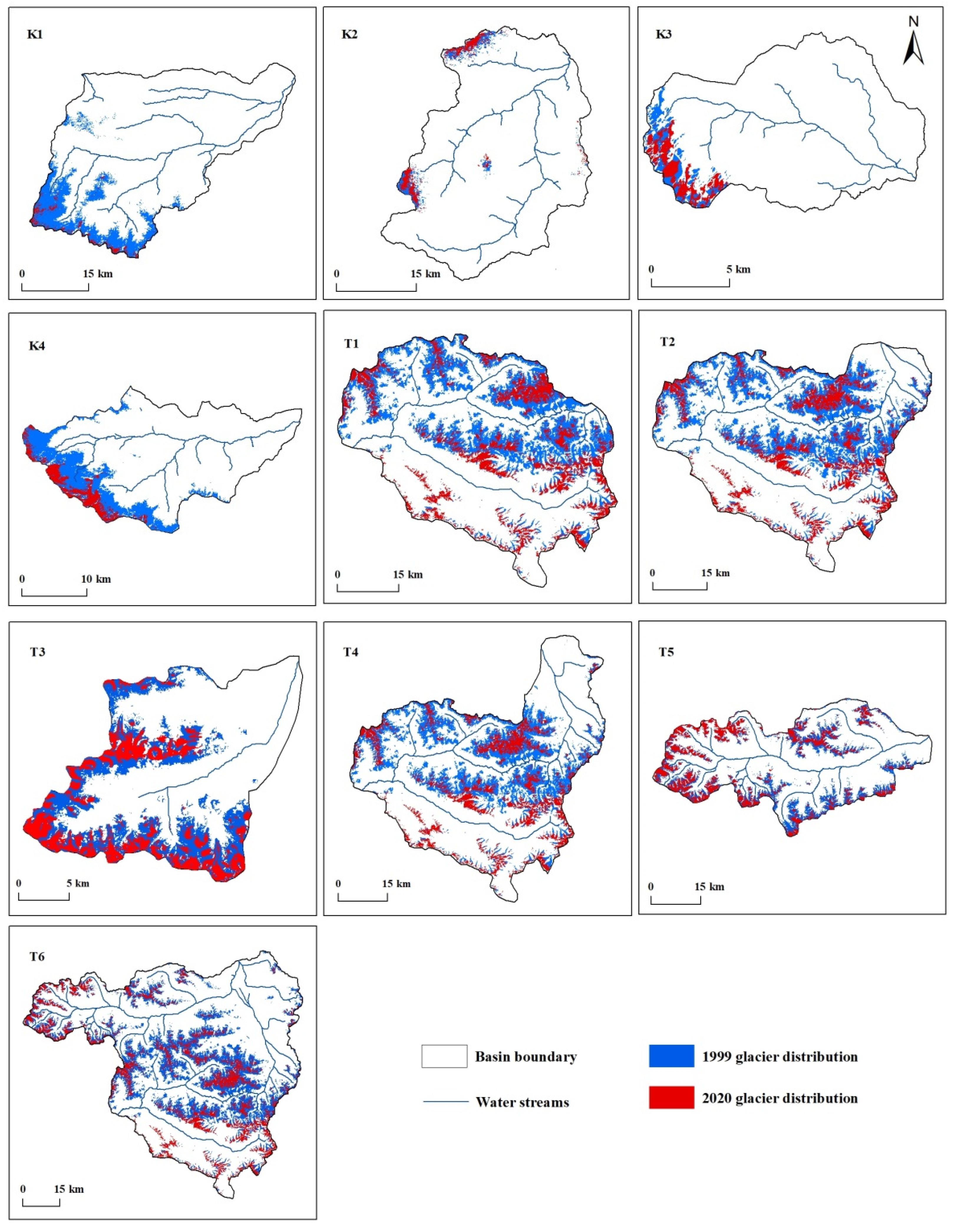
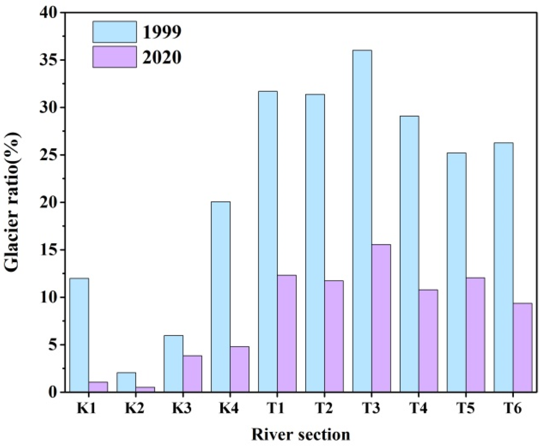
3.1. Changes of Glacier Area
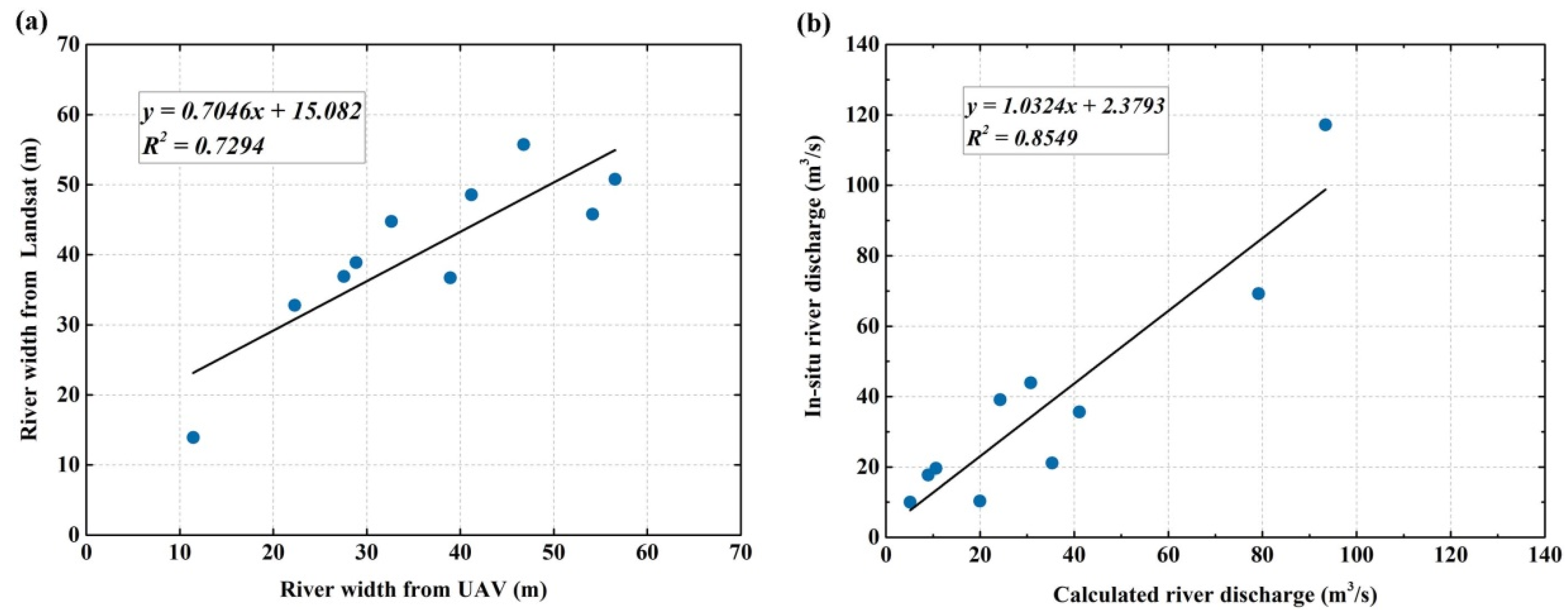
3.2. River Discharge from UAV and Satellite Remote Sensing
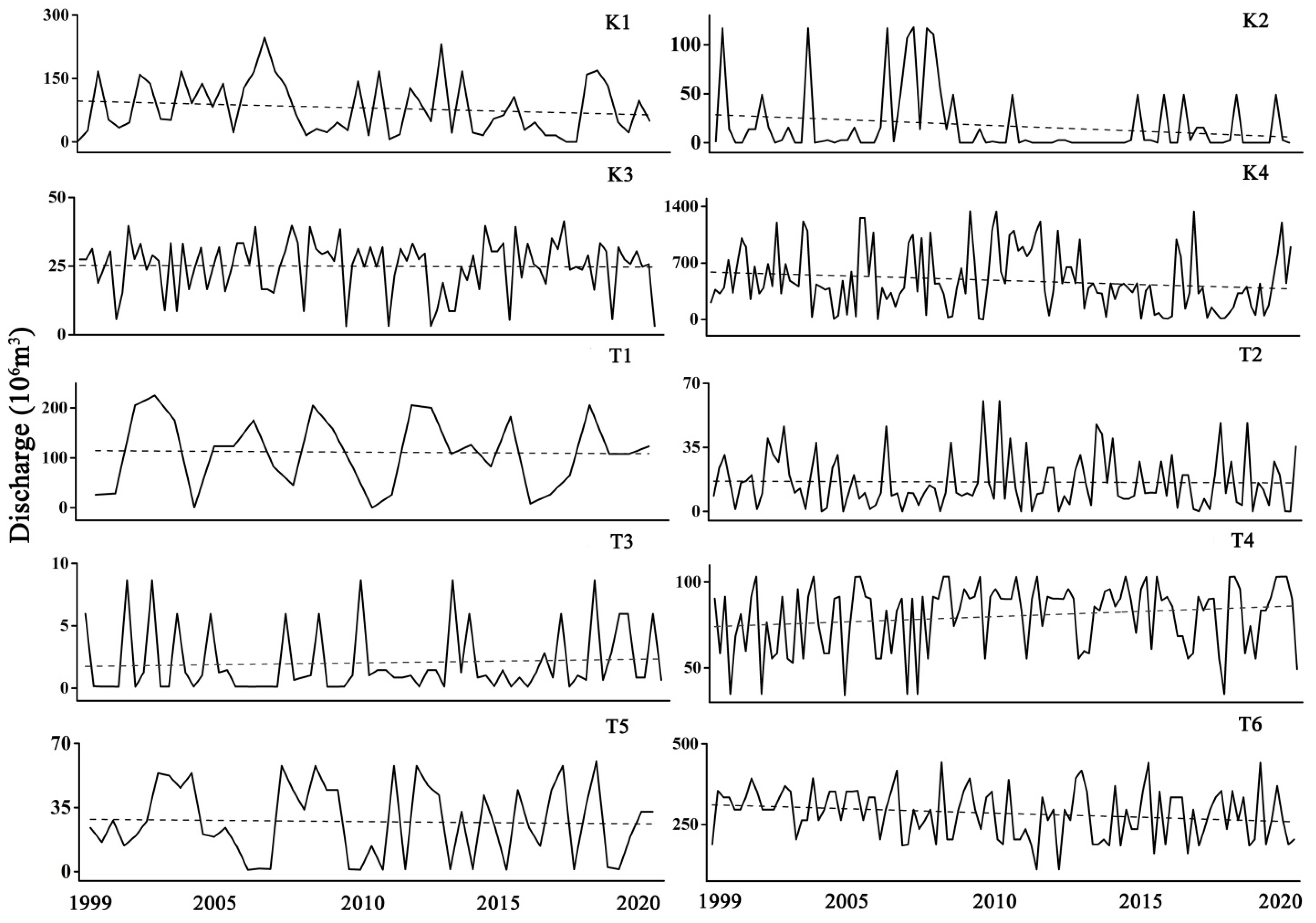
3.3. Glacier Discharge from Water Balance Model
4. Discussion
4.1. Motivation and the Study Objective
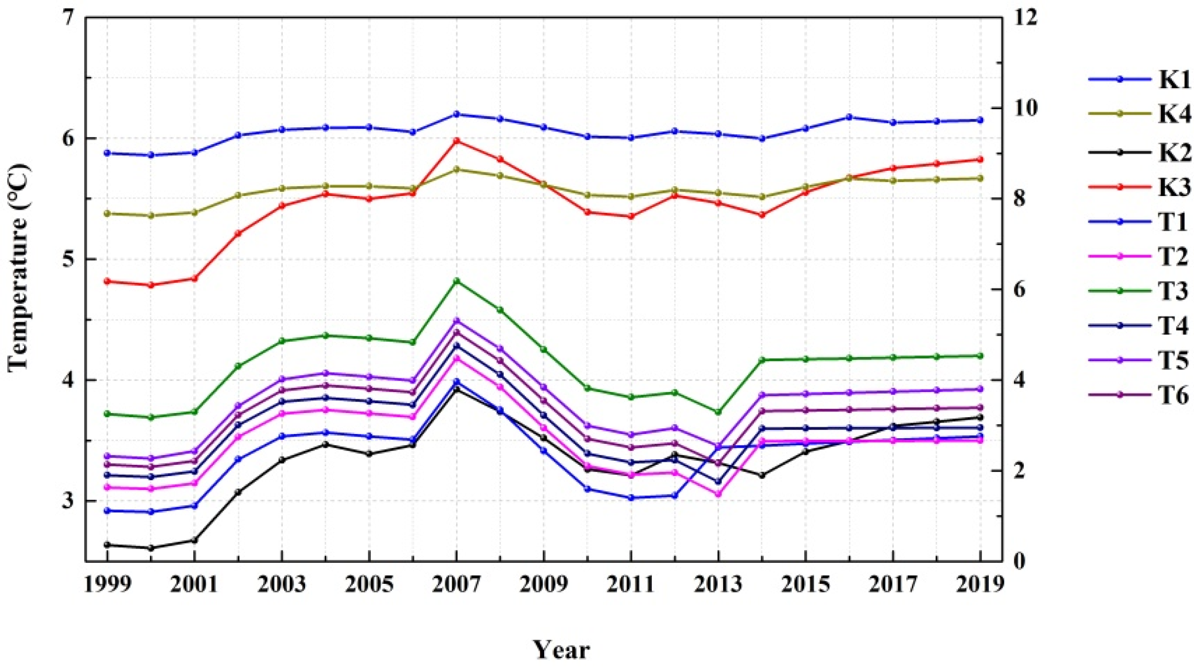
4.2. Changing of Climatic Factor
4.3. Runoff Characteristics of High-Altitude Headwaters
4.4. Opportunities and Challenges of UAV-Based Survey on High Mountain Areas
5. Conclusions
Author Contributions
Funding
Conflicts of Interest
References
- Mekonnen, M.; Hoekstra, A. Four billion people facing severe water scarcity. Sci. Adv. 2016, 2, e1500323. [Google Scholar] [CrossRef] [PubMed] [Green Version]
- The World Economic Forum. Global Risks 2015; The World Economic Forum: Geneva, Switzerland, 2015. [Google Scholar]
- Immerzeel, W.W.; van Beek, L.P.H.; Konz, M.; Shrestha, A.B.; Bierkens, M.F.P. Hydrological response to climate change in a glacierized catchment in the Himalayas. Clim. Chang. 2012, 110, 721–736. [Google Scholar] [CrossRef] [PubMed] [Green Version]
- Tak, S.; Keshari, A.K. Investigating mass balance of Parvati glacier in Himalaya using satellite imagery based model. Sci. Rep. 2020, 10, 12211. [Google Scholar] [CrossRef]
- Sakai, A.; Fujita, K. Contrasting glacier responses to recent climate change in high-mountain Asia. Sci. Rep. 2017, 7, 13717. [Google Scholar] [CrossRef] [PubMed]
- Luo, Y.; Xiaolei, W.; Piao, S.; Sun, L.; Ciais, P.; Zhang, Y.; Ma, C.; Gan, R.; He, C. Contrasting streamflow regimes induced by melting glaciers across the Tien Shan—Pamir—North Karakoram. Sci. Rep. 2018, 8, 16470. [Google Scholar] [CrossRef]
- Chen, Y.; Li, W.; Deng, H.; Fang, G.; Li, Z. Changes in central Asia’s water tower: Past, present and future. Sci. Rep. 2016, 6, 35458. [Google Scholar] [CrossRef]
- Miles, E.; McCarthy, M.; Dehecq, A.; Kneib, M.; Fugger, S.; Pellicciotti, F. Health and sustainability of glaciers in High Mountain Asia. Nat. Commun. 2021, 12, 2868. [Google Scholar] [CrossRef]
- Pendleton, S.; Miller, G.; Lifton, N.; Lehman, S.; Southon, J.; Crump, S.; Anderson, R. Rapidly receding Arctic Canada glaciers revealing landscapes continuously ice-covered for more than 40,000 years. Nat. Commun. 2019, 10, 445. [Google Scholar] [CrossRef]
- St Pierre, K.; Lehnherr, I.; Poulain, A.; Gardner, A.; St Louis, V.; Smol, J.; Schiff, S.; Arnott, S.; Findlay, D.; Findlay, W.; et al. Contemporary limnology of the rapidly changing glacierized watershed of the world’s largest High Arctic lake. Sci. Rep. 2019, 9, 4447. [Google Scholar] [CrossRef] [Green Version]
- Singh, D.V.; Jain, S.; Goyal, M. An assessment of snow-glacier melt runoff under climate change scenarios in the Himalayan basin. Stoch. Environ. Res. Risk Assess. 2021, 35, 2067–2092. [Google Scholar] [CrossRef]
- Baraer, M.; Mark, B.; McKenzie, J.; Condom, T.; Bury, J.; Huh, K.; Portocarrero, C.; Gomez, J.; Rathay, S. Glacier recession and water resources in Peru’s Cordillera Blanca. J. Glaciol. 2012, 58, 134–150. [Google Scholar] [CrossRef] [Green Version]
- Zhao, Q.; Ding, Y.; Wang, J.; Gao, H.; Zhang, S.; Zhao, C.; Junli, X.; Han, H.; Shangguan, D. Projecting climate change impacts on hydrological processes on the Tibetan Plateau with model calibration against the Glacier Inventory Data and observed streamflow. J. Hydrol. 2019, 573, 60–81. [Google Scholar] [CrossRef]
- Duethmann, D.; Bolch, T.; Farinotti, D.; Kriegel, D.; Vorogushyn, S.; Merz, B.; Pieczonka, T.; Jiang, T.; Buda, S.; Güntner, A. Attribution of streamflow trends in snow- and glacier melt dominated catchments of the Tarim River, Central Asia. Water Resour. Res. 2015, 51, 4727–4750. [Google Scholar] [CrossRef] [Green Version]
- Huss, M.; Farinotti, D.; Bauder, A.; Funk, M. Modelling runoff from highly glacierized alpine drainage basins in a changing climate. Hydrol. Process. 2008, 22, 3888–3902. [Google Scholar] [CrossRef]
- Bliss, A.; Hock, R.; Radić, V. Global response of glacier runoff to twenty-first century climate change. J. Geophys. Res. Earth Surf. 2014, 119, 717–730. [Google Scholar] [CrossRef]
- Huss, M.; Hock, R. Global-scale hydrological response to future glacier mass loss. Nat. Clim. Chang. 2018, 8, 135–140. [Google Scholar] [CrossRef] [Green Version]
- Sorg, A.; Huss, M.; Rohrer, M. The days of plenty might soon be over in glacierized Central Asian catchments. Environ. Res. Lett. 2014, 9, 104018. [Google Scholar] [CrossRef]
- Pohl, E.; Gloaguen, R.; Andermann, C.; Knoche, M. Glacier melt buffers river runoff in the Pamir Mountains. Water Resour. Res. 2017, 53, 2467–2489. [Google Scholar] [CrossRef]
- Unger-Shayesteh, K.; Vorogushyn, S.; Farinotti, D.; Gafurov, A.; Duethmann, D.; Mandychev, A.; Merz, B. What do we know about past changes in the water cycle of Central Asian headwaters? A review. Glob. Planet. Chang. 2013, 110, 4–25. [Google Scholar] [CrossRef]
- Normatov, I.; Normatov, P. Climate change impact on hydrological characteristics and water availability of the Mountain Pamir Rivers. Proc. Int. Assoc. Hydrol. Sci. 2020, 383, 31–41. [Google Scholar] [CrossRef]
- Hagg, W.; Hoelzle, M.; Wagner, S.; Klose, Z. Estimation of future glaciation and runoff in the Tanimas basin, Eastern Pamirs. Hydrol. Earth Syst. Sci. Discuss. 2011, 8, 62–73. [Google Scholar] [CrossRef]
- Knoche, M.; Merz, R.; Lindner, M.; Weise, S. Bridging glaciological and hydrological trends in the pamir mountains, central Asia. Water 2017, 9, 422. [Google Scholar] [CrossRef] [Green Version]
- Razavi, T.; Coulibaly, P. Streamflow prediction in ungauged basins: Review of regionalization methods. J. Hydrol. Eng. 2013, 18, 958–975. [Google Scholar] [CrossRef]
- Bjerklie, D.M.; Ayotte, J.D.; Cahillane, M.J. Simulating Hydrologic Response to Climate Change Scenarios in Four Selected Watersheds of New Hampshire; U.S. Geological Survey Scientific Investigations Report; United States Geological Survey: Reston, VA, USA, 2015; pp. 2015–5047. [Google Scholar]
- Zarco-Tejada, P.; Whiting, M.; Ustin, S. Temporal and spatial relationships between within-field yield variability in cotton and high-spatial hyperspectral remote sensing imagery. Agron. J. 2005, 97, 641–653. [Google Scholar] [CrossRef] [Green Version]
- Bishop, C.; Liu, J.G.; Mason, P. Hyperspectral remote sensing for mineral exploration in Pulang, Yunnan Province, China. Int. J. Remote Sens. 2011, 32, 2409–2426. [Google Scholar] [CrossRef]
- Heiden, U.; Segl, K.; Roessner, S.; Kaufmann, H. Determination of robust spectral features for identification of urban surface materials in hyperspectral remote sensing data. Remote Sens. Environ. 2007, 111, 537–552. [Google Scholar] [CrossRef] [Green Version]
- Gleason, C.; Wang, J. Theoretical basis for at-many-stations hydraulic geometry (AMHG). Geophys. Res. Lett. 2015, 42, H52D-08. [Google Scholar] [CrossRef] [Green Version]
- Huang, Q.; Long, D.; Du, M.; Zeng, C.; Qiao, G.; Li, X.; Hou, A.; Hong, Y. Discharge estimation in high-mountain regions with improved methods using multisource remote sensing: A case study of the Upper Brahmaputra River. Remote Sens. Environ. 2018, 219, 115–134. [Google Scholar] [CrossRef]
- Garambois, p.-a.; Monnier, J. Inference of effective river properties from remotely sensed observations of water surface. Adv. Water Resour. 2015, 79, 103–120. [Google Scholar] [CrossRef]
- Shi, Z.; Chen, Y.; Liu, Q.; Huang, C. Discharge estimation using harmonized landsat and sentinel-2 product: Case studies in the murray darling basin. Remote Sens. 2020, 12, 2810. [Google Scholar] [CrossRef]
- Kerr, J.; Purkis, S. An algorithm for optically-deriving water depth from multispectral imagery in coral reef landscapes in the absence of ground-truth data. Remote Sens. Environ. 2018, 210, 307–324. [Google Scholar] [CrossRef]
- Zhao, C.S.; Zhang, C.B.; Yang, S.T.; Liu, C.M.; Xiang, H.; Sun, Y.; Yang, Z.Y.; Zhang, Y.; Yu, X.Y.; Shao, N.F.; et al. Calculating e-flow using UAV and ground monitoring. J. Hydrol. 2017, 552, 351–365. [Google Scholar] [CrossRef]
- Lewin, J.; Gibbard, P. Quaternary river terraces in England: Forms, sediments and processes. Geomorphology 2010, 120, 293–311. [Google Scholar] [CrossRef]
- Yang, S.; Wang, P.; Lou, H.; Wang, J.; Zhao, C.; Gong, T. Estimating river discharges in ungauged catchments using the slope area method and unmanned aerial vehicle. Water 2019, 11, 2361. [Google Scholar] [CrossRef] [Green Version]
- Yang, S.; Wang, j.; Wang, P.; Gong, T.; Liu, H. Low altitude unmanned aerial vehicles (UAVs) and satellite remote sensing are used to calculated river discharge attenuation coefficients of ungauged catchments in arid desert. Water 2019, 11, 2633. [Google Scholar] [CrossRef] [Green Version]
- Wang, P.; Yang, S.; Wang, J.; Pan, T.; Zhang, S.; Gong, T. Discharge estimation with hydraulic geometry using unmanned aerial vehicle and remote sensing. J. Hydraul. Eng. 2020, 4, 492–504. [Google Scholar] [CrossRef]
- Lou, H.; Wang, P.; Yang, S.; Hao, F.; Ren, X.; Wang, Y.; Shi, L.; Wang, J.; Gong, T. Combining and comparing an unmanned aerial vehicle and multiple remote sensing satellites to calculate long-term river discharge in an ungauged water source region on the Tibetan plateau. Remote Sens. 2020, 12, 2155. [Google Scholar] [CrossRef]
- Yang, S.; Li, C.; Lou, H.; Wang, P.; Wang, J.; Ren, X. Performance of an unmanned aerial vehicle (UAV) in calculating the flood peak discharge of ephemeral rivers combined with the incipient motion of moving stones in arid ungauged regions. Remote Sens. 2020, 12, 1610. [Google Scholar] [CrossRef]
- RGI Consortium. Randolph Glacier Inventory-A Dataset of Global Glacier Outlines; Version 6.0; Technical Report; Global Land Ice Measurements from Space: Boulder, CO, USA, 2017. [Google Scholar] [CrossRef]
- Turner, D.; Lucieer, A.; Wallace, L. Direct georeferencing of ultrahigh-resolution UAV imagery. IEEE Trans. Geosci. Remote Sens. 2014, 52, 2738–2745. [Google Scholar] [CrossRef]
- Ruzgienė, B.; Berteška, T.; Gečyte, S.; Jakubauskienė, E.; Aksamitauskas, Č. The surface modelling based on UAV Photogrammetry and qualitative estimation. Measurement 2015, 73, 619–623. [Google Scholar] [CrossRef]
- Zhang, C.B.; Yang, S.T.; Zhao, C.S.; Lou, H.Z.; Zhang, Y.C.; Bai, J.; Wang, Z.W.; Guan, Y.B.; Zhang, Y. Topographic data accuracy verification of small consumer UAV. Remote Sens. 2018, 22, 185–195. [Google Scholar] [CrossRef]
- He, C. Hydrological characteristics of Kezi River in Xinjiang. Grand Water 2019, 41, 151–152. [Google Scholar]
- Mao, W.; Sun, B.; Wang, T.; Luo, G.; Zhang, C.; Huo, L. Change trends of temperature, precipitation and runoff volume in the Kaxgar river basin since recent 50 years. Arid Zone Res. 2006, 23, 531–538. [Google Scholar]
- Wulder, M.A.; White, J.C.; Goward, S.N.; Masek, J.G.; Irons, J.R.; Herold, M.; Cohen, W.B.; Loveland, T.R.; Woodcock, C.E. Landsat continuity: Issues and opportunities for land cover monitoring. Remote Sens. Environ. 2008, 112, 955–969. [Google Scholar] [CrossRef]
- Dee, D.P.; Uppala, S.M.; Simmons, A.J.; Berrisford, P.; Poli, P.; Kobayashi, S.; Andrae, U.; Balmaseda, M.A.; Balsamo, G.; Bauer, D.P.; et al. The ERA-Interim reanalysis: Configuration and performance of the data assimilation system. Q. J. R. Meteorol. Soc. 2011, 137, 553–597. [Google Scholar] [CrossRef]
- McFeeters, S.K. The use of normalized difference water index (NDWI) in the delineation of open water features. Int. J. Remote Sens. 1996, 7, 1425–1432. [Google Scholar] [CrossRef]
- Gao, B.-C. NDWI?A normalized difference water index for remote sensing of vegetation liquid water from space. Remote Sens. Environ. 1996, 58, 257–266. [Google Scholar] [CrossRef]
- Xu, H. Modification of normalized difference water index (NDWI) to enhance open water features in remotely sensed imagery. Int. J. Remote Sens. 2006, 27, 3025–3033. [Google Scholar] [CrossRef]
- Keshava, N.; Mustard, J.F. Spectral unmixing. IEEE Signal Process. Mag. 2002, 19, 44–57. [Google Scholar] [CrossRef]
- Pal, M.; Foody, G.M. Feature selection for classification of hyperspectral data by SVM. IEEE Trans. Geosci. Remote Sens. 2010, 48, 2297–2307. [Google Scholar] [CrossRef] [Green Version]
- Mountrakis, G.; Im, J.; Ogole, C. Support vector machines in remote sensing: A review. Isprs J. Photogramm. Remote Sens. 2011, 66, 247–259. [Google Scholar] [CrossRef]
- Zhang, Z.; Liu, S.; Junfeng, W.; Junli, X.; Guo, W.; Bao, W.; Jiang, Z. Mass change of glaciers in Muztag Ata-Kongur Tagh, Eastern Pamir, China from 1971/76 to 2013/14 as derived from remote sensing data. PLoS ONE 2016, 11, e0147327. [Google Scholar] [CrossRef] [PubMed]
- Sivapalan, M.; Takeuchi, K.; Franks, S.; Gupta, V.; Karambiri, H.; Lakshmi, V.; Liang, X.; McDonnell, J.; Mendiondo, E.; O’Connell, E.; et al. IAHS Decade on predictions in ungauged basins (PUB), 2003–2012: Shaping an exciting future for the hydrological sciences. Hydrol. Sci. J. 2003, 48, 857–880. [Google Scholar] [CrossRef] [Green Version]
- Cook, A.; Copland, L.; Noël, B.; Stokes, C.; Bentley, M.; Sharp, M.; Bingham, R.G.; van den Broeke, M. Atmospheric forcing of rapid marine-terminating glacier retreat in the Canadian Arctic Archipelago. Sci. Adv. 2019, 5, eaau8507. [Google Scholar] [CrossRef] [Green Version]
- Mętrak, M.; Chachulski, Ł.; Navruzshoev, D.; Pawlikowski, P.; Rojan, E.; Sulwiński, M.; Suska-Malawska, M. Nature’s patchwork: How water sources and soil salinity determine the distribution and structure of halophytic plant communities in arid environments of the Eastern Pamir. PLoS ONE 2017, 12, e0174496. [Google Scholar] [CrossRef]
- Yao, T.; Thompson, L.; Yang, W.; Yu, W.; Gao, Y.; Guo, X.; Yang, X.; Duan, K.; Zhao, H.; Xu, B.; et al. Different glacier status with atmospheric circulations in Tibetan plateau and surroundings. Nat. Clim. Chang. 2012, 2, 663–667. [Google Scholar] [CrossRef]
- Zhang, L. Climate change and its impact on the eco-environment of the three-rivers headwater region on the Tibetan plateau, China. Int. J. Environ. Res. Public Health 2015, 12, 12057–12081. [Google Scholar] [CrossRef] [Green Version]
- Huss, M. Present and future cotribution of glacier storage change to runoff from macroscale drainage basins in Europe. Water Resour. Res. 2011, 47, W07511. [Google Scholar] [CrossRef] [Green Version]
- Chevallier, P.; Pouyaud, B.; Mojaïsky, M.; Bolgov, M.; Olsson, O.; Bauer, M.; Froebrich, J. River flow regime and snow cover of the Pamir Alay (Central Asia) in a changing climate. Hydrol. Sci. J. 2014, 59, 1491–1506. [Google Scholar] [CrossRef]
- Kure, S.; Jang, S.; Ohara, N.; Kavvas, M.; Chen, Z.Q. Hydrologic impact of regional climate change for the snowfed and glacierfed river basins in the republic of Tajikistan: Hydrological response of flow to climate change. Hydrol. Process. 2013, 27, 4057–4070. [Google Scholar] [CrossRef]
- Bahr, D.; Pfeffer, W.; Sassolas, C.; Meier, M. Response time of glaciers as a function of size and mass balance: 1. Theory. J. Geophys. Res. 1998, 103, 9777–9782. [Google Scholar] [CrossRef]
- Finaev, A. Climatic changes in the mountain glacier area of Pamir. In Ice Physics and the Natural Environment; Springer: Berlin, Germany, 1999; pp. 289–295. [Google Scholar] [CrossRef]
- Barnett, T.; Adam, J.; Lettenmaier, D. Potential impacts of a warming climate on water availability in snow-dominated regions. Nature 2005, 438, 303–309. [Google Scholar] [CrossRef] [PubMed]
- Khan, Z.; Eichi, V.; Haefele, S.; Garnett, T.; Miklavcic, S. Estimation of vegetation indices for high-throughput phenotyping of wheat using aerial imaging. Plant Methods 2018, 14, 20. [Google Scholar] [CrossRef] [PubMed]
- Anderson, K.; Gaston, K.J. Lightweight unmanned aerial vehicles will revolutionize spatial ecology. Front. Ecol. Environ. 2013, 11, 138–146. [Google Scholar] [CrossRef] [Green Version]
- Howell, T.L.; Singh, K.K.; Smart, L. Structure from motion techniques for estimating the volume of wood chips. In High Spatial Resolution Remote Sensing; CRC Press: Boca Raton, FL, USA, 2018; pp. 149–164. [Google Scholar] [CrossRef]
- Bjerklie, D.; Dingman, S.; Vorosmarty, C.; Bolster, C.; Congalton, R. Evaluating the potential for measuring river discharge from space. J. Hydrol. 2003, 278, 17–38. [Google Scholar] [CrossRef]
- Ling, F.; Cai, X.; Li, W.; Xiao, F.; Li, X.; Du, Y. Monitoring river discharge with remotely sensed imagery using river island area as an indicator. J. Appl. Remote Sens. 2012, 6, 063564. [Google Scholar] [CrossRef]
- Watson, C.S.; King, O.; Miles, E.; Quincey, D. Optimising NDWI supraglacial pond classification on Himalayan debris-covered glaciers. Remote Sens. Environ. 2018, 217, 414–425. [Google Scholar] [CrossRef]



| Basin | Section | Location | Altitude | Overlapped Rate (%) | Flight Height (m) | Number of Images | Control Area (km2) |
|---|---|---|---|---|---|---|---|
| Kashgar River Basin | K1 | 39°33′34″, 75°03′55″ | 1976 | 90 | 120 | 268 | 1497.19 |
| K2 | 38°31′41″, 76°03′06″ | 2250 | 90 | 120 | 216 | 1163 | |
| K3 | 38°34′28″, 76°02′49″ | 2351 | 90 | 120 | 288 | 141.25 | |
| K4 | 38°58′51″,75°28′57″ | 1992 | 90 | 120 | 305 | 532.79 | |
| Taxkorgan River Basin | T1 | 36°51′03″, 75°31′10″ | 4287 | 90 | 120 | 218 | 2514.35 |
| T2 | 37°01′27″, 75°31′49″ | 3908 | 90 | 120 | 234 | 2956.18 | |
| T3 | 37°08′46″, 75°27′58″ | 3932 | 90 | 120 | 276 | 364.24 | |
| T4 | 37°09′05″, 75°28′16″ | 3725 | 90 | 120 | 246 | 3246.58 | |
| T5 | 37°12′34″, 75°22′24″ | 3587 | 90 | 120 | 288 | 1943.22 | |
| T6 | 37°19′12″, 75°25′04″ | 3497 | 90 | 120 | 268 | 6150.97 |
Publisher’s Note: MDPI stays neutral with regard to jurisdictional claims in published maps and institutional affiliations. |
© 2021 by the authors. Licensee MDPI, Basel, Switzerland. This article is an open access article distributed under the terms and conditions of the Creative Commons Attribution (CC BY) license (https://creativecommons.org/licenses/by/4.0/).
Share and Cite
Wufu, A.; Yang, S.; Chen, Y.; Lou, H.; Li, C.; Ma, L. Estimation of Long-Term River Discharge and Its Changes in Ungauged Watersheds in Pamir Plateau. Remote Sens. 2021, 13, 4043. https://doi.org/10.3390/rs13204043
Wufu A, Yang S, Chen Y, Lou H, Li C, Ma L. Estimation of Long-Term River Discharge and Its Changes in Ungauged Watersheds in Pamir Plateau. Remote Sensing. 2021; 13(20):4043. https://doi.org/10.3390/rs13204043
Chicago/Turabian StyleWufu, Adilai, Shengtian Yang, Yun Chen, Hezhen Lou, Chaojun Li, and Ligang Ma. 2021. "Estimation of Long-Term River Discharge and Its Changes in Ungauged Watersheds in Pamir Plateau" Remote Sensing 13, no. 20: 4043. https://doi.org/10.3390/rs13204043
APA StyleWufu, A., Yang, S., Chen, Y., Lou, H., Li, C., & Ma, L. (2021). Estimation of Long-Term River Discharge and Its Changes in Ungauged Watersheds in Pamir Plateau. Remote Sensing, 13(20), 4043. https://doi.org/10.3390/rs13204043


