Satellite-Derived Barrier Response and Recovery Following Natural and Anthropogenic Perturbations, Northern Chandeleur Islands, Louisiana
Abstract
:1. Introduction
2. Materials and Methods
2.1. Study Area
2.2. Data Sources and Image Pre-Processing
2.3. Land-Cover Classification and Feature Extraction
2.4. Change Analyses
3. Results
3.1. Classification Accuracy
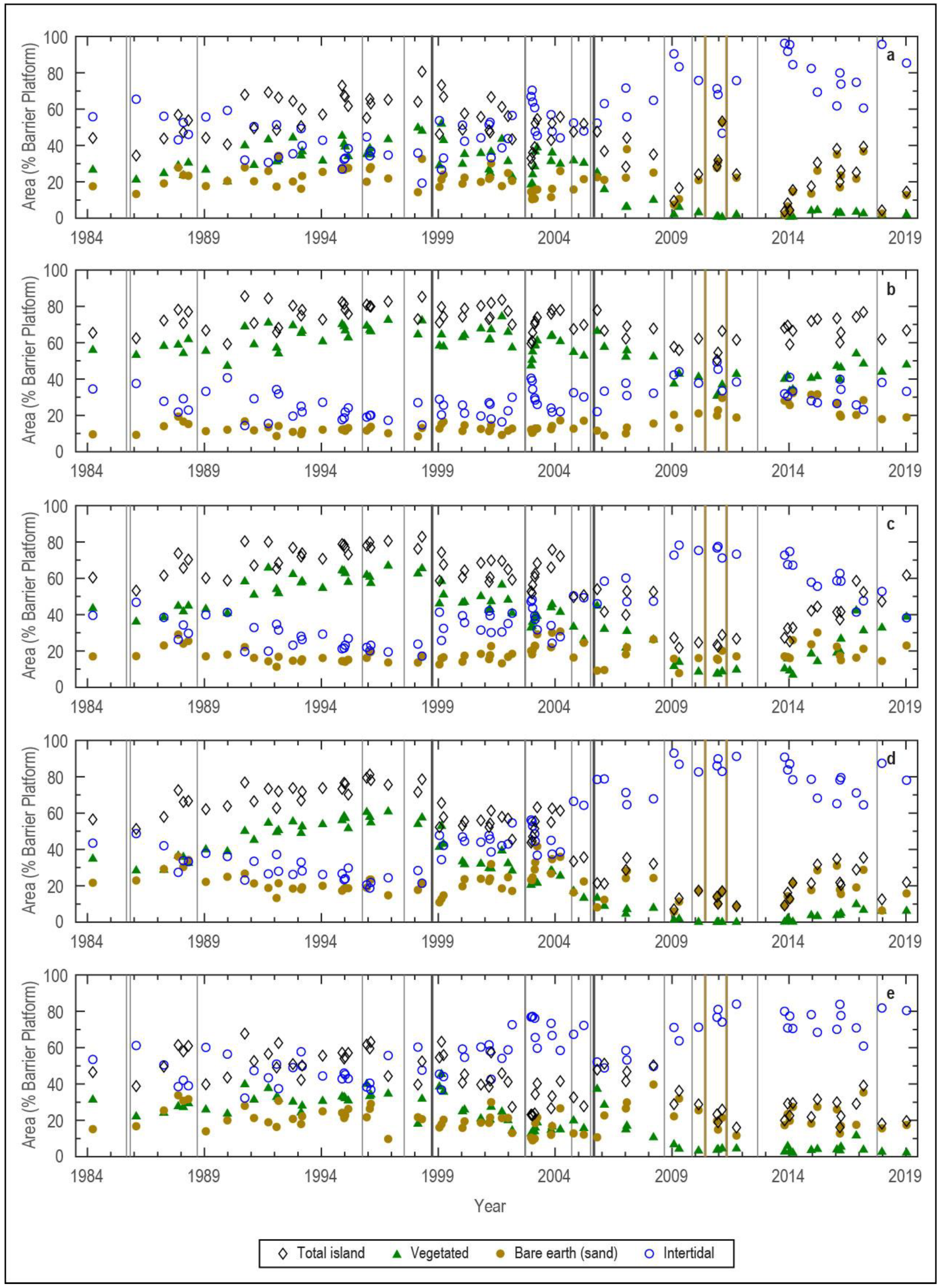
3.2. Temporal Land-Cover Changes
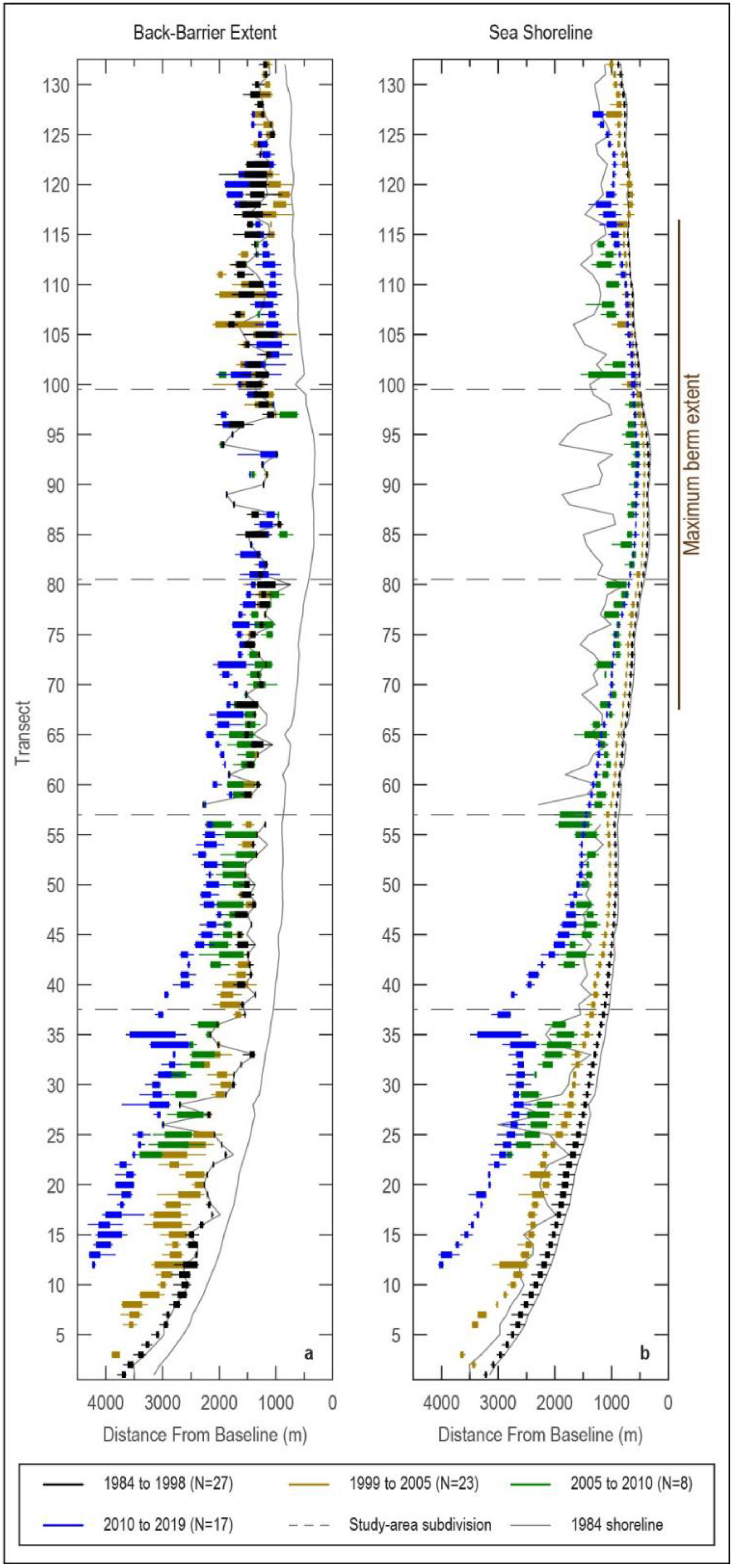
3.3. Barrier Metrics
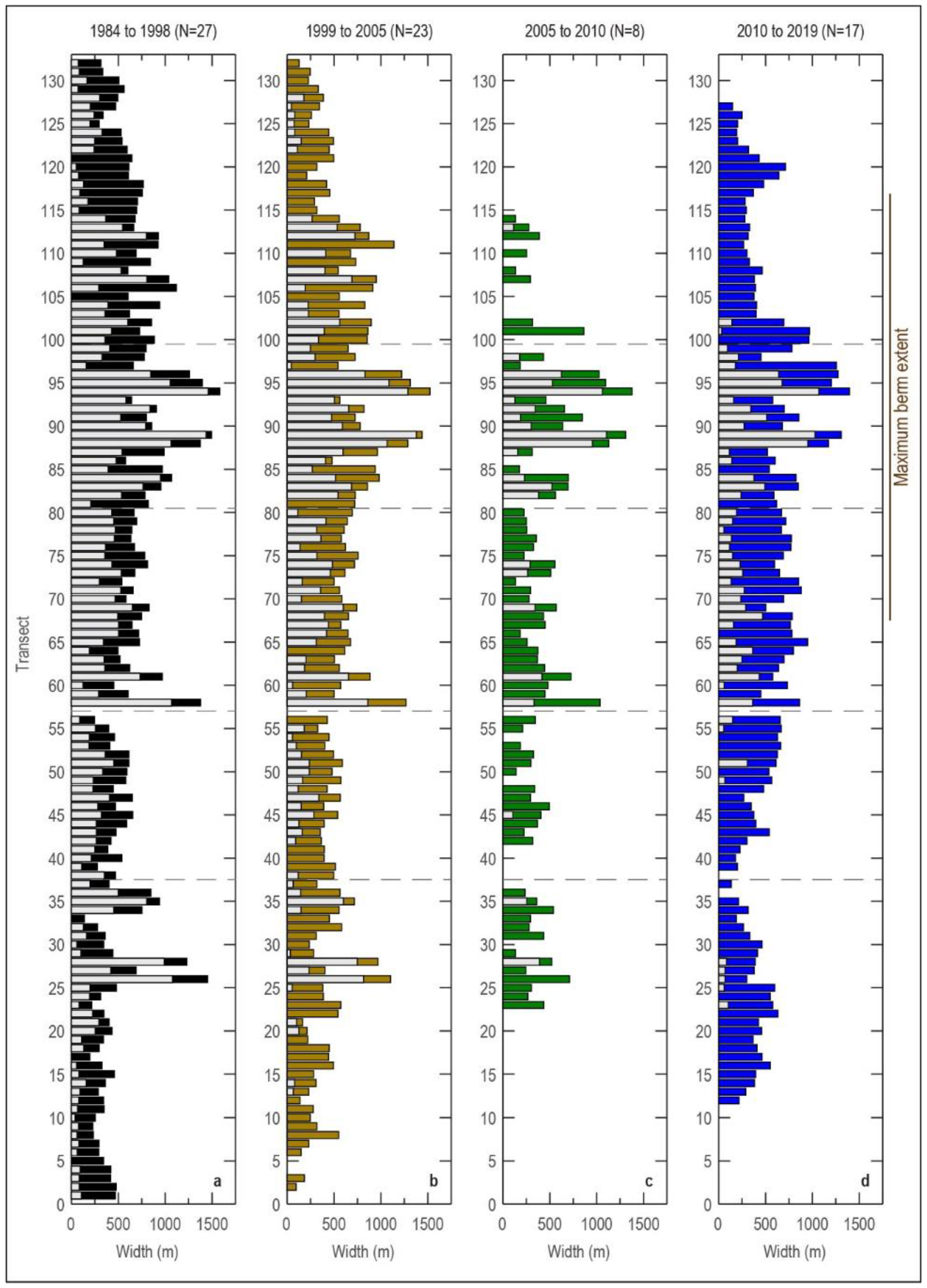
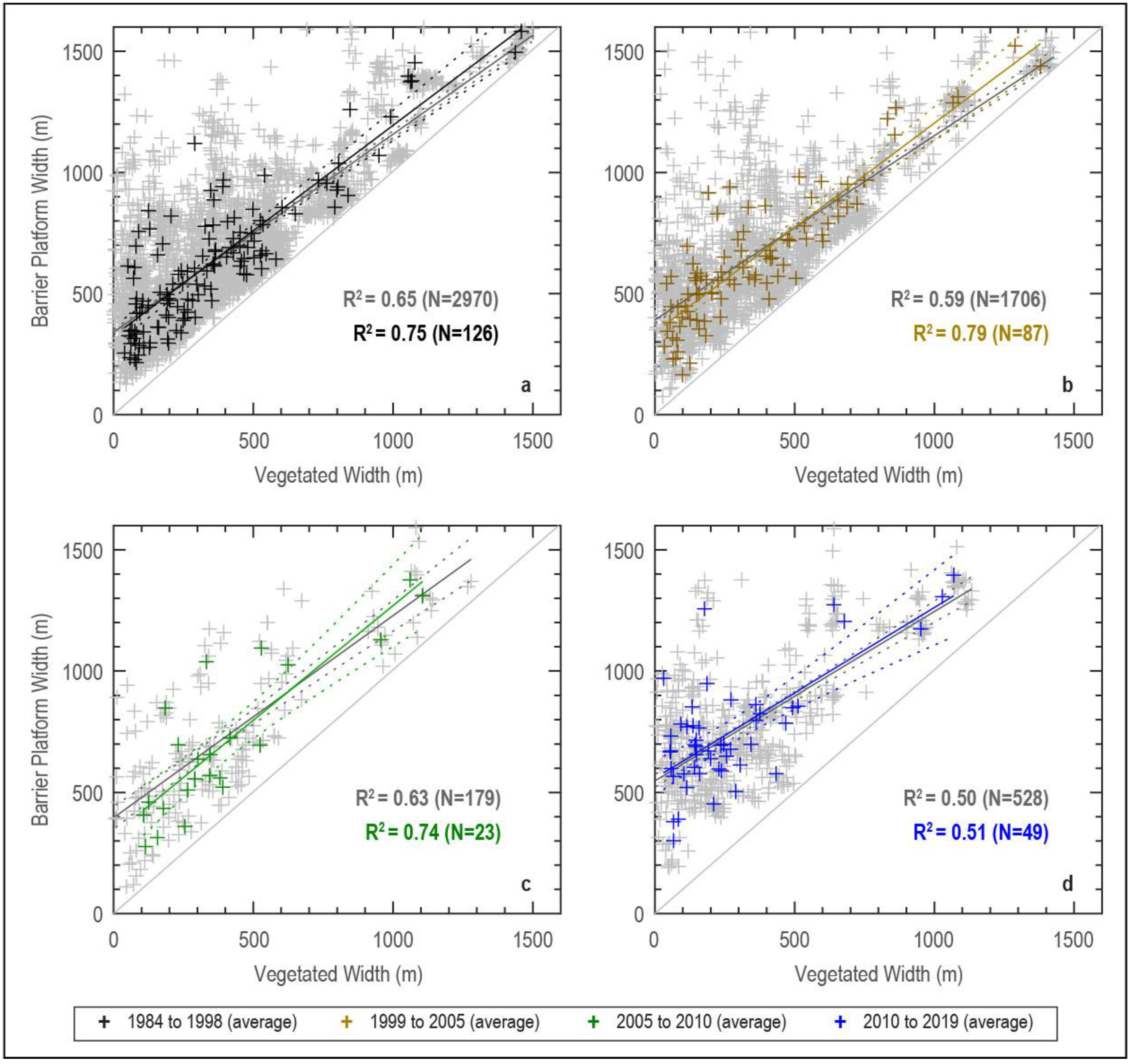
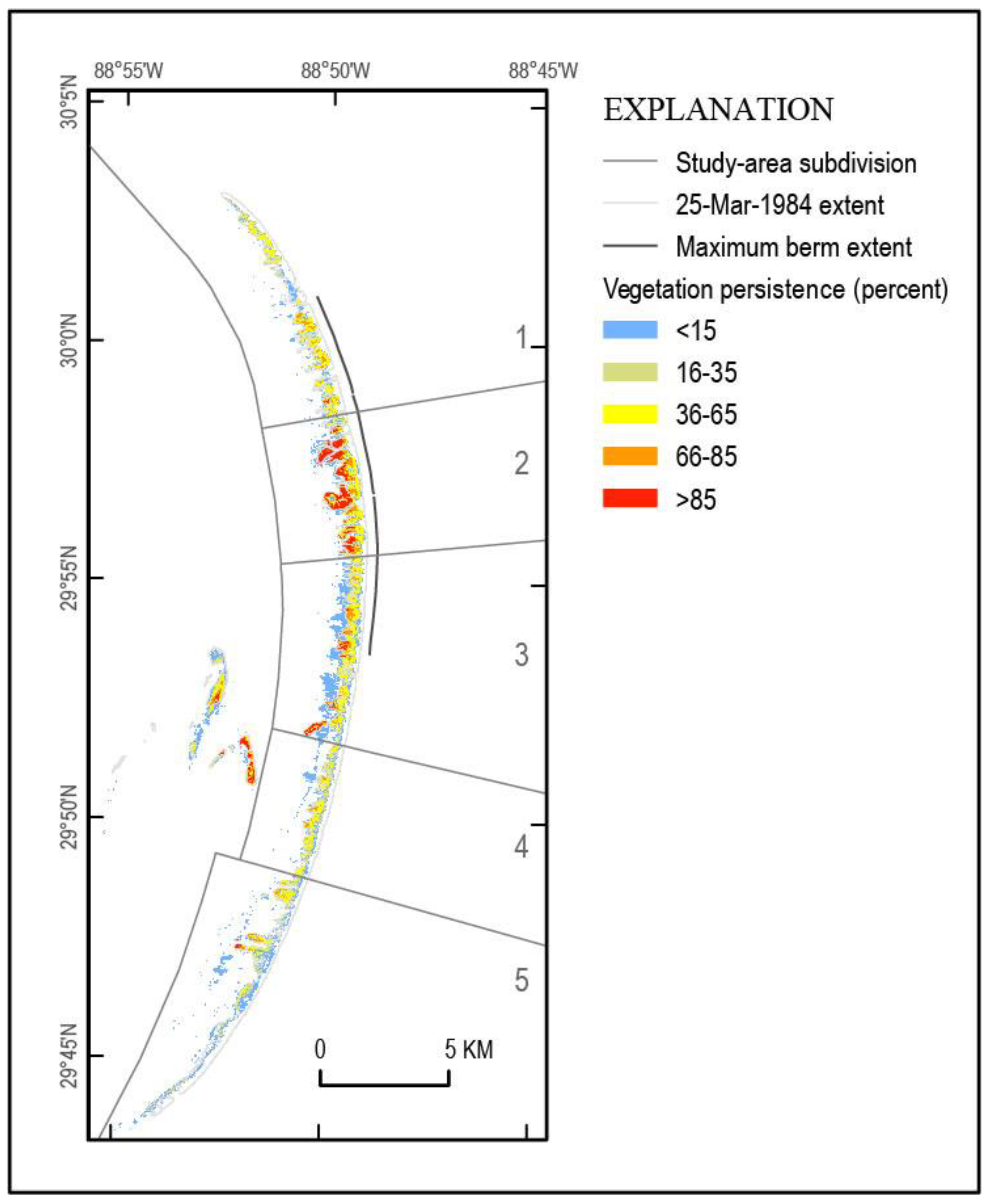
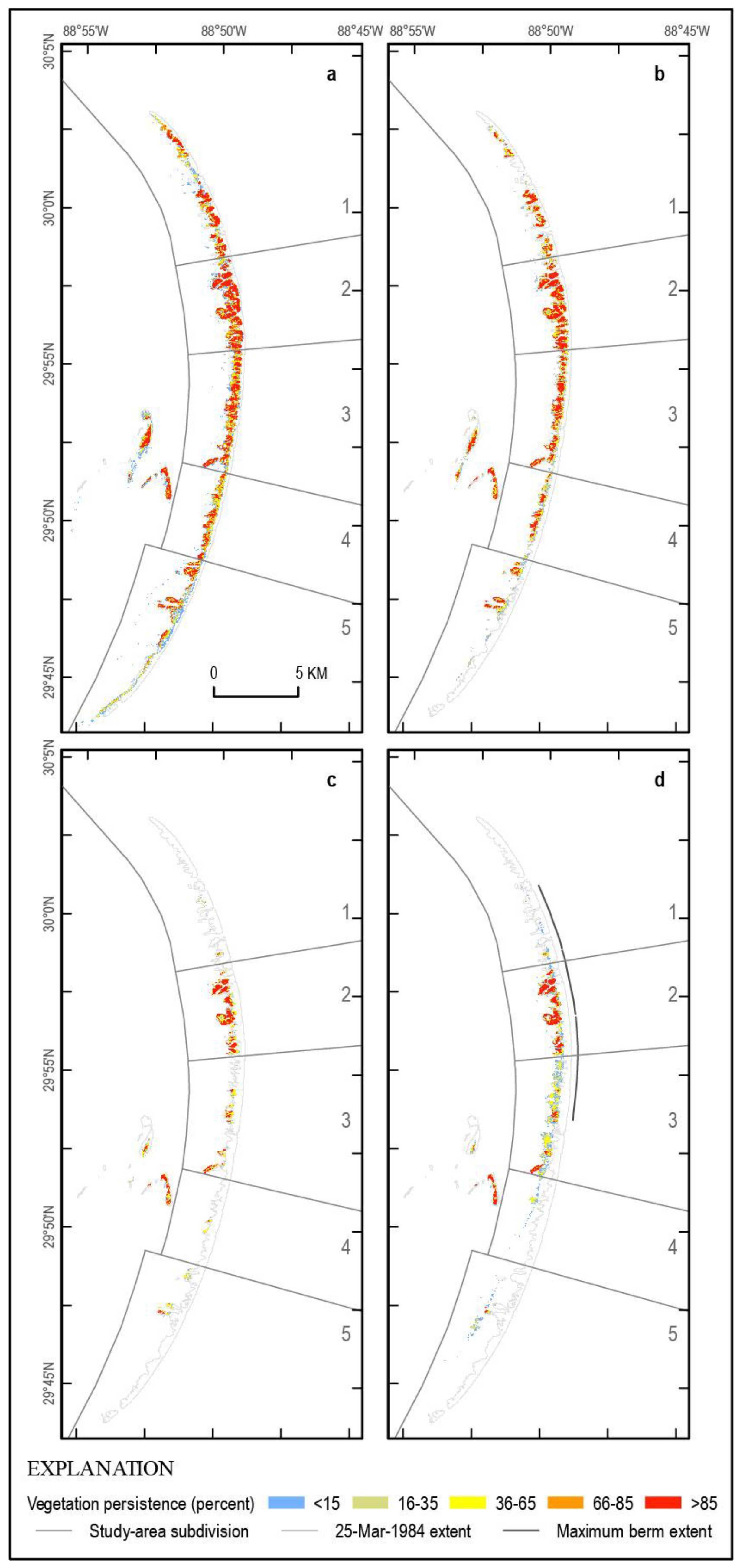
3.4. Vegetation Persistence
4. Discussion
4.1. Automatic Thresholding of Mulitple Spectral Indices for Rapidly Assessing Coastal Metrics
4.2. Implications for Barrier-Island Evolution and Resiliency
5. Conclusions
- Land-cover changes show decadal-scale oscillations related to storm–recovery cycles. Linear trends derived from shorter and (or) less resolved time series are biased toward storm impacts and may significantly overpredict land-loss rates and the timing of barrier morphologic state changes.
- Patterns of landscape change and recovery following storms varied alongshore and were directly related to vegetation extent and persistence trends. Although redistribution of emplaced berm sediment contributed to post-2010 increases in intertidal and emergent land areas, natural post-storm barrier recovery was occurring simultaneously with berm-related changes, making it difficult to decouple the natural and anthropogenic contributions.
- We show a transition from a persistent, emergent vegetated (marsh) platform to newly vegetated back-barrier flats landward of the historic barrier footprint and interpret that this implies increased vulnerability of the extant landscape to future storms and RSLR.
Supplementary Materials
Author Contributions
Funding
Data Availability Statement
Acknowledgments
Conflicts of Interest
References
- Cooper, J.A.G.; Green, A.N.; Loureiro, C. Geological Constraints on Mesoscale Coastal Barrier Behaviour. Glob. Planet. Chang. 2018, 168, 15–34. [Google Scholar] [CrossRef] [Green Version]
- Rink, W.J.; López, G.I. OSL-Based Lateral Progradation and Aeolian Sediment Accumulation Rates for the Apalachicola Barrier Island Complex, North Gulf of Mexico, Florida. Geomorphology 2010, 123, 330–342. [Google Scholar] [CrossRef]
- Dougherty, A.J. Extracting a Record of Holocene Storm Erosion and Deposition Preserved in the Morphostratigraphy of a Prograded Coastal Barrier. Cont. Shelf Res. 2014, 86, 116–131. [Google Scholar] [CrossRef]
- Raff, J.L.; Shawler, J.L.; Ciarletta, D.J.; Hein, E.A.; Lorenzo-Trueba, J.; Hein, C.J. Insights into Barrier-Island Stability Derived from Transgressive/Regressive State Changes of Parramore Island, Virginia. Mar. Geol. 2018, 403, 1–19. [Google Scholar] [CrossRef]
- Wright, E.; Kruse, S.; Forman, S.L.; Harris, M.S. Millennial Scale Development of a Southeastern United States Spit. J. Coast. Res. 2018, 34, 255–271. [Google Scholar] [CrossRef]
- Kennedy, D.M.; Oliver, T.S.N.; Tamura, T.; Murray-Wallace, C.V.; Thom, B.G.; Rosengren, N.J.; Ierodiaconou, D.; Augustinus, P.; Leach, C.; Gao, J.; et al. Holocene Evolution of the Ninety Mile Beach Sand Barrier, Victoria, Australia: The Role of Sea Level, Sediment Supply and Climate. Mar. Geol. 2020, 430, 106366. [Google Scholar] [CrossRef]
- Torres, J.; Kulp, M.; FitzGerald, D.; Georgiou, I.; Lepper, K. Geomorphic and Temporal Evolution of a Mississippi Delta Flanking Barrier Island: Grand Isle, LA. Mar. Geol. 2020, 430, 106341. [Google Scholar] [CrossRef]
- Miselis, J.L.; McNinch, J.E. Calculating Shoreline Erosion Potential Using Nearshore Stratigraphy and Sediment Volume: Outer Banks, North Carolina. J. Geophys. Res. Earth Surf. 2006, 111, 1–15. [Google Scholar] [CrossRef] [Green Version]
- Hapke, C.J.; Lentz, E.E.; Gayes, P.T.; McCoy, C.A.; Hehre, R.; Schwab, W.C.; Williams, S.J. A Review of Sediment Budget Imbalances along Fire Island, New York: Can Nearshore Geologic Framework and Patterns of Shoreline Change Explain the Deficit? J. Coast. Res. 2010, 2010, 510–522. [Google Scholar] [CrossRef]
- Hapke, C.J.; Plant, N.G.; Henderson, R.E.; Schwab, W.C.; Nelson, T.R. Decoupling Processes and Scales of Shoreline Morphodynamics. Mar. Geol. 2016, 381, 42–53. [Google Scholar] [CrossRef] [Green Version]
- Lentz, E.E.; Hapke, C.J. Geologic Framework Influences on the Geomorphology of an Anthropogenically Modified Barrier Island: Assessment of Dune/Beach Changes at Fire Island, New York. Geomorphology 2011, 126, 82–96. [Google Scholar] [CrossRef]
- Twichell, D.C.; Flocks, J.G.; Pendleton, E.A.; Baldwin, W.E. Geologic Controls on Regional and Local Erosion Rates of Three Northern Gulf of Mexico Barrier-Island Systems. J. Coast. Res. 2013, 63, 32–45. [Google Scholar] [CrossRef] [Green Version]
- Cowell, P.J.; Kinsela, M.A. Shoreface Controls on Barrier Evolution and Shoreline Change. In Barrier Dynamics and Response to Changing Climate; Moore, L.J., Murray, A.B., Eds.; Springer International Publishing: New York, NY, USA, 2018; pp. 243–275. ISBN 978-3-319-68086-6. [Google Scholar]
- Houser, C.; Hapke, C.; Hamilton, S. Controls on Coastal Dune Morphology, Shoreline Erosion and Barrier Island Response to Extreme Storms. Geomorphology 2008, 100, 223–240. [Google Scholar] [CrossRef]
- Fearnley, S.M.; Miner, M.D.; Kulp, M.; Bohling, C.; Penland, S. Hurricane Impact and Recovery Shoreline Change Analysis of the Chandeleur Islands, Louisiana, USA: 1855 to 2005. Geo-Mar. Lett. 2009, 29, 455–466. [Google Scholar] [CrossRef]
- Lentz, E.E.; Hapke, C.J.; Stockdon, H.F.; Hehre, R.E. Improving Understanding of Near-Term Barrier Island Evolution through Multi-Decadal Assessment of Morphologic Change. Mar. Geol. 2013, 337, 125–139. [Google Scholar] [CrossRef] [Green Version]
- Terrano, J.F.; Flocks, J.G.; Smith, K.E.L. Analysis of Shoreline and Geomorphic Change for Breton Island, Louisiana, from 1869 to 2014; Open-File Report 2016-1039; U.S. Geological Survey: Reston, VA, USA, 2016; Volume 2016-1039, pp. 1–43.
- Doran, K.J.; Long, J.W.; Birchler, J.J.; Brenner, O.T.; Hardy, M.W.; Morgan, K.L.M.; Stockdon, H.F.; Torres, M.L. Lidar-Derived Beach Morphology (Dune Crest, Dune Toe, and Shoreline) for U.S. Sandy Coastlines (Ver. 4.0, October 2020) 2017; USGS: St. Petersburg, FL, USA, 2017.
- Brenner, O.T.; Lentz, E.E.; Hapke, C.J.; Henderson, R.E.; Wilson, K.E.; Nelson, T.R. Characterizing Storm Response and Recovery Using the Beach Change Envelope: Fire Island, New York. Geomorphology 2018, 300, 189–202. [Google Scholar] [CrossRef] [Green Version]
- Byrnes, M.R.; Berlinghoff, J.L.; Griffee, S.F.; Lee, D.M. Louisiana Barrier Island Comprehensive Monitoring Program (BICM): Phase 2—Updated Shoreline Compilation and Change Assessment, 1880s to 2015; Louisiana Coastal Protection and Restoration Authority: Metairie, LA, USA, 2018; pp. 1–46.
- Conery, I.; Walsh, J.P.; Reide Corbett, D. Hurricane Overwash and Decadal-Scale Evolution of a Narrowing Barrier Island, Ocracoke Island, NC. Estuaries Coasts 2018, 41, 1626–1642. [Google Scholar] [CrossRef]
- Do, A.T.K.; de Vries, S.; Stive, M.J.F. Beach Evolution Adjacent to a Seasonally Varying Tidal Inlet in Central Vietnam. J. Coast. Res. 2018, 34, 6–25. [Google Scholar] [CrossRef] [Green Version]
- Hapke, C.J.; Brenner, O.; Hehre, R.; Reynolds, B.J. Coastal Change from Hurricane Sandy and the 2012–13 Winter Storm Season: Fire Island, New York; Open-File Report 2013-1231; U.S. Geological Survey: Reston, VA, USA, 2013; pp. 1–37.
- Levine, N.S.; Kaufman, C.C. Land Use, Erosion, and Habitat Mapping on an Atlantic Barrier Island, Sullivan’s Island, South Carolina. J. Maps 2008, 4, 161–174. [Google Scholar] [CrossRef]
- Waqas, M.; Nazeer, M.; Shahzad, M.I.; Zia, I. Spatial and Temporal Variability of Open-Ocean Barrier Islands along the Indus Delta Region. Remote Sens. 2019, 11, 437. [Google Scholar] [CrossRef] [Green Version]
- Morton, R.A. Historical Changes in the Mississippi-Alabama Barrier Islands and the Roles of Extreme Storms, Sea Level, and Human Activities; Open-File Report 2020-1030; U.S. Geological Survey: Reston, VA, USA, 2007; pp. 1–38.
- Sallenger, A.H.; Wright, C.W.; Howd, P.; Doran, K.; Guy, K.; Lavoie, D. Extreme coastal changes on the Chandeleur Islands, Louisiana, during and after Hurricane Katrina. In Sand Resources, Regional Geology, and Coastal Processes of the Chandeleur Islands Coastal System—An Evaluation of the Breton National Wildlife Refuge; U.S Geological Survey Scientific Investigations Report 2009-5252; U.S. Geological Survey: Reston, VA, USA, 2009; pp. 27–36. [Google Scholar]
- Sopkin, K.L.; Stockdon, H.F.; Doran, K.S.; Plant, N.G.; Morgan, K.L.M.; Guy, K.K.; Smith, K.E.L. Hurricane Sandy: Observations and Analysis of Coastal Change; Open-File Report 2014-1088; U.S. Geological Survey: Reston, VA, USA, 2014; pp. 1–64.
- Matias, A.; Carrasco, A.R.; Loureiro, C.; Almeida, S.; Ferreira, Ó. Nearshore and Foreshore Influence on Overwash of a Barrier Island. J. Coast. Res. 2014, 70, 675–680. [Google Scholar] [CrossRef]
- Walters, D.; Moore, L.J.; Vinent, O.D.; Fagherazzi, S.; Mariotti, G. Interactions between Barrier Islands and Backbarrier Marshes Affect Island System Response to Sea Level Rise: Insights from a Coupled Model. J. Geophys. Res. Earth Surf. 2014, 119, 2013–2031. [Google Scholar] [CrossRef] [Green Version]
- Deaton, C.D.; Hein, C.J.; Kirwan, M.L. Barrier Island Migration Dominates Ecogeomorphic Feedbacks and Drives Salt Marsh Loss along the Virginia Atlantic Coast, USA. Geology 2017, 45, 123–126. [Google Scholar] [CrossRef] [Green Version]
- Zinnert, J.C.; Stallins, J.A.; Brantley, S.T.; Young, D.R. Crossing Scales: The Complexity of Barrier-Island Processes for Predicting Future Change. BioScience 2017, 67, 39–52. [Google Scholar] [CrossRef]
- McCarthy, M.J.; Halls, J.N. Habitat Mapping and Change Assessment of Coastal Environments: An Examination of WorldView-2, QuickBird, and IKONOS Satellite Imagery and Airborne LiDAR for Mapping Barrier Island Habitats. ISPRS Int. J. Geo-Inf. 2014, 3, 297–325. [Google Scholar] [CrossRef] [Green Version]
- Anderson, C.P.; Carter, G.A.; Funderburk, W.R. The Use of Aerial RGB Imagery and LIDAR in Comparing Ecological Habitats and Geomorphic Features on a Natural versus Man-Made Barrier Island. Remote Sens. 2016, 8, 602. [Google Scholar] [CrossRef] [Green Version]
- Douglas, S.H.; Bernier, J.C.; Smith, K.E.L. Analysis of Multi-Decadal Wetland Changes, and Cumulative Impact of Multiple Storms 1984 to 2017. Wetl. Ecol. Manag. 2018, 26, 1121–1142. [Google Scholar] [CrossRef] [Green Version]
- Halls, J.N.; Frishman, M.A.; Hawkes, A.D. An Automated Model to Classify Barrier Island Geomorphology Using Lidar Data and Change Analysis (1998–2014). Remote Sens. 2018, 10, 1109. [Google Scholar] [CrossRef] [Green Version]
- Suir, G.M.; Sasser, C.E. Redistribution and Impacts of Nearshore Berm Sediments on the Chandeleur Barrier Islands, Louisiana. Ocean Coast. Manag. 2019, 168, 103–116. [Google Scholar] [CrossRef]
- Zinnert, J.C.; Via, S.M.; Nettleton, B.P.; Tuley, P.A.; Moore, L.J.; Stallins, J.A. Connectivity in Coastal Systems: Barrier Island Vegetation Influences Upland Migration in a Changing Climate. Glob. Chang. Biol. 2019, 25, 2419–2430. [Google Scholar] [CrossRef]
- Enwright, N.M.; SooHoo, W.M.; Dugas, J.L.; Conzelmann, C.P.; Laurenzano, C.; Lee, D.M.; Mouton, K.; Stelly, S.J. Louisiana Barrier Island Comprehensive Monitoring Program: Mapping Habitats in Beach, Dune, and Intertidal Environments along the Louisiana Gulf of Mexico Shoreline, 2008 and 2015–16; Open-File Report 2020-1030; U.S. Geological Survey: Reston, VA, USA, 2020; pp. 1–57.
- Schieder, N.W.; Walters, D.C.; Kirwan, M.L. Massive Upland to Wetland Conversion Compensated for Historical Marsh Loss in Chesapeake Bay, USA. Estuaries Coasts 2018, 41, 940–951. [Google Scholar] [CrossRef]
- Suir, G.M.; Jones, W.R.; Garber, A.L.; Gailani, J.Z. Landscape Evolution of the Oil Spill Mitigation Sand Berm in the Chandeleur Islands, Louisiana; Technical Report ERDC TR-16-15; U.S. Army Engineer Research and Development Center: Lafayette, LA, USA, 2016; pp. 1–41.
- Penland, S.; Boyd, R.; Suter, J.R. Transgressive Depositional Systems of the Mississippi Delta Plain; a Model for Barrier Shoreline and Shelf Sand Development. J. Sediment. Res. 1988, 58, 932–949. [Google Scholar] [CrossRef]
- Otvos, E.G.; Carter, G.A. Regressive and Transgressive Barrier Islands on the North-Central Gulf Coast—Contrasts in Evolution, Sediment Delivery, and Island Vulnerability. Geomorphology 2013, 198, 1–19. [Google Scholar] [CrossRef]
- Moore, L.J.; Patsch, K.; List, J.H.; Williams, S.J. The Potential for Sea-Level-Rise-Induced Barrier Island Loss: Insights from the Chandeleur Islands, Louisiana, USA. Mar. Geol. 2014, 355, 244–259. [Google Scholar] [CrossRef]
- Fearnley, S.; Brien, L.; Martinez, L.; Miner, M.; Kulp, M.; Penland, S. Louisiana Barrier Island Comprehensive Monitoring Program (BICM) Volume 5—Chenier Plain, South-Central Louisiana, and Chandeleur Islands, Habitat Mapping and Change Analysis 1996 to 2005, Part 1—Methods for Habitat Mapping and Change Analysis 1996 to 2005; University of New Orleans, Pontchartrain Institute for Environmental Sciences: New Orleans, LA, USA, 2009; pp. 1–11. [Google Scholar]
- Murray, N.J.; Phinn, S.R.; Clemens, R.S.; Roelfsema, C.M.; Fuller, R.A. Continental Scale Mapping of Tidal Flats across East Asia Using the Landsat Archive. Remote Sens. 2012, 4, 3417–3426. [Google Scholar] [CrossRef] [Green Version]
- Murray, N.J.; Phinn, S.R.; DeWitt, M.; Ferrari, R.; Johnston, R.; Lyons, M.B.; Clinton, N.; Thau, D.; Fuller, R.A. The Global Distribution and Trajectory of Tidal Flats. Nature 2019, 565, 222–225. [Google Scholar] [CrossRef]
- Couvillion, B.R.; Beck, H.; Schoolmaster, D.; Fischer, M. Land Area Change in Coastal Louisiana (1932 to 2016); Scientific Investigations Map 3381; U.S. Geological Survey: Reston, VA, USA, 2017; pp. 1–16.
- Mentaschi, L.; Vousdoukas, M.I.; Pekel, J.-F.; Voukouvalas, E.; Feyen, L. Global Long-Term Observations of Coastal Erosion and Accretion. Sci. Rep. 2018, 8, 12876. [Google Scholar] [CrossRef] [PubMed] [Green Version]
- Yang, L.; Jin, S.; Danielson, P.; Homer, C.; Gass, L.; Bender, S.M.; Case, A.; Costello, C.; Dewitz, J.; Fry, J.; et al. A New Generation of the United States National Land Cover Database: Requirements, Research Priorities, Design, and Implementation Strategies. ISPRS J. Photogramm. Remote Sens. 2018, 146, 108–123. [Google Scholar] [CrossRef]
- Li, N.; Li, L.; Lu, D.; Zhang, Y.; Wu, M. Detection of Coastal Wetland Change in China: A Case Study in Hangzhou Bay. Wetl. Ecol. Manag. 2019, 27, 103–124. [Google Scholar] [CrossRef]
- Lopes, C.L.; Mendes, R.; Caçador, I.; Dias, J.M. Evaluation of Long-Term Estuarine Vegetation Changes through Landsat Imagery. Sci. Total Environ. 2019, 653, 512–522. [Google Scholar] [CrossRef]
- Zhao, Y.; Feng, D.; Yu, L.; Cheng, Y.; Zhang, M.; Liu, X.; Xu, Y.; Fang, L.; Zhu, Z.; Gong, P. Long-Term Land Cover Dynamics (1986–2016) of Northeast China Derived from a Multi-Temporal Landsat Archive. Remote Sens. 2019, 11, 599. [Google Scholar] [CrossRef] [Green Version]
- Hagenaars, G.; de Vries, S.; Luijendijk, A.P.; de Boer, W.P.; Reniers, A.J.H.M. On the Accuracy of Automated Shoreline Detection Derived from Satellite Imagery: A Case Study of the Sand Motor Mega-Scale Nourishment. Coast. Eng. 2018, 133, 113–125. [Google Scholar] [CrossRef]
- Luijendijk, A.; Hagenaars, G.; Ranasinghe, R.; Baart, F.; Donchyts, G.; Aarninkhof, S. The State of the World’s Beaches. Sci. Rep. 2018, 8, 6641. [Google Scholar] [CrossRef]
- Nelson, T.R.; Miselis, J.L. Method for observing breach geomorphic evolution: Satellite observation of the Fire Island wilderness breach. In Coastal Sediments 2019; World Scientific: Singapore, 2019; pp. 71–84. [Google Scholar]
- Vos, K.; Harley, M.D.; Splinter, K.D.; Simmons, J.A.; Turner, I.L. Sub-Annual to Multi-Decadal Shoreline Variability from Publicly Available Satellite Imagery. Coast. Eng. 2019, 150, 160–174. [Google Scholar] [CrossRef]
- Pardo-Pascual, J.E.; Sánchez-García, E.; Almonacid-Caballer, J.; Palomar-Vázquez, J.M.; Priego de los Santos, E.; Fernández-Sarría, A.; Balaguer-Beser, Á. Assessing the Accuracy of Automatically Extracted Shorelines on Microtidal Beaches from Landsat 7, Landsat 8 and Sentinel-2 Imagery. Remote Sens. 2018, 10, 326. [Google Scholar] [CrossRef] [Green Version]
- Bernier, J.C.; Miselis, J.L.; Buster, N.A.; Flocks, J.G. Application of sediment end-member analysis for understanding sediment fluxes, northern Chandeleur Islands, Louisiana. In Coastal Sediments 2019—Procedsings of the 9th International Conference, Tampa/St. Petersburg, FL, USA,27–31 May 2019; Wang, P., Rosati, J.D., Vallee, M., Eds.; World Scientific Publishing: Singapore, 2019; pp. 25–38. [Google Scholar]
- Miselis, J.L.; Long, J.W.; Dalyander, P.S.; Flocks, J.G.; Buster, N.A.; Mickey, R.C. Integrating geophysical and oceanographic data to assess interannual variability in longshore sediment transport. In Proceedings of the Coastal Sediments 2015, San Diego, CA, USA, 11–15 May 2015; Wang, P., Rosati, J.D., Cheng, J., Eds.; World Scientific Publishing: Singapore, 2015; pp. 113–126, ISBN 978-981-4689-96-0. [Google Scholar]
- Buster, N.A.; Bernier, J.C.; Miselis, J.L.; Plant, N.G. Integrated Terrestrial and Submerged Sediment Flux Assessment along the Northern Chandeleur Islands, Louisiana, USA. In Proceedings of the Coastal Sediments 2019, Tampa/St. Petersburg, FL, USA, 27–31 May 2019. [Google Scholar]
- Miselis, J.L.; Dalyander, P.S.; Long, J.W.; Buster, N.A.; Mickey, R.C.; Bernier, J.C.; Plant, N.G. Natural and Human-Related Variability in Sediment Flux at the Chandeleur Islands, Louisiana. In Proceedings of the State of the Coast Conference, Virtual, 2–4 June 2021. [Google Scholar]
- Plant, N.G.; Flocks, J.; Stockdon, H.F.; Long, J.W.; Guy, K.; Thompson, D.M.; Cormier, J.M.; Smith, C.G.; Miselis, J.L.; Dalyander, P.S. Predictions of Barrier Island Berm Evolution in a Time-Varying Storm Climatology. J. Geophys. Res. Earth Surf. 2014, 119, 300–316. [Google Scholar] [CrossRef] [Green Version]
- U.S. Fish and Wildlife Service Comprehensive Conservation Plan. Delta and Breton National Wildlife Refuges, St. Bernard and Plaquemines Parishes, Louisiana; U.S. Fish and Wildlife Service: Atlanta, GA, USA, 2008; pp. 1–140.
- Reyes, E.; Georgiou, I.; Reed, D.; McCorquodale, A. Using Models to Evaluate the Effects of Barrier Islands on Estuarine Hydrodynamics and Habitats: A Numerical Experiment. J. Coast. Res. 2005, 44, 176–185. [Google Scholar]
- FitzGerald, D.M.; Georgiou, I.; Kulp, M. Restoration of the Chandeleur Barrier Arc, Louisiana. J. Coast. Res. 2016, 75, 1282–1286. [Google Scholar] [CrossRef]
- Miner, M.D.; Kulp, M.; Weathers, H.D.; Flocks, J. Historical (1869–2007) Seafloor Evolution and Sediment Dynamics along the Chandeleur Islands. In Sand Resources, Regional Geology, and Coastal Processes of the Chandeleur Islands Coastal System—An Evaluation of the Breton National Wildlife Refuge; Lavoie, D., Ed.; U.S Geological Survey Scientific Investigations Report 2009-5252; U.S. Geological Survey: Reston, VA, USA, 2009; pp. 47–74. [Google Scholar]
- Georgiou, I.Y.; Schindler, J.K. Wave Forecasting and Longshore Sediment Transport Gradients along a Transgressive Barrier Island: Chandeleur Islands, Louisiana. Geo-Mar. Lett. 2009, 29, 467–476. [Google Scholar] [CrossRef]
- Ellis, J.; Stone, G.W. Numerical Simulation of Net Longshore Sediment Transport and Granulometry of Surficial Sediments along Chandeleur Island, Louisiana, USA. Mar. Geol. 2006, 232, 115–129. [Google Scholar] [CrossRef]
- Twichell, D.; Pendelton, E.; Baldwin, W.; Flocks, J. Geologic mapping of distribution and volume of potential resources. In Sand Resources, Regional Geology, and Coastal Processes of the Chandeleur Islands Coastal System—An Evaluation of the Breton National Wildlife Refuge; Lavoie, D., Ed.; U.S Geological Survey Scientific Investigations Report 2009-5252; U.S. Geological Survey: Reston, VA, USA, 2009; pp. 75–98. [Google Scholar]
- Hymel, M.K. 2007 Operations, Maintenance, and Monitoring Report for Chandeleur Islands Marsh Restoration (PO-27); Louisiana Department of Natural Resources: New Orleans, LA, USA, 2007; pp. 1–57.
- Coastal Planning & Engineering, Inc. Chandeleur Island Emergency Berm 180-Day Monitoring Report; Louisiana Coastal Protection and Restoration Authority: Baton Rouge, LA, USA, 2012; pp. 1–62.
- Kahn, J.H. Geomorphic Recovery of the Chandeleur Islands, Louisiana, after a Major Hurricane. J. Coast. Res. 1986, 2, 337–344. [Google Scholar]
- Sherwood, C.R.; Long, J.W.; Dickhudt, P.J.; Dalyander, P.S.; Thompson, D.M.; Plant, N.G. Inundation of a Barrier Island (Chandeleur Islands, Louisiana, USA) during a Hurricane: Observed Water-Level Gradients and Modeled Seaward Sand Transport. J. Geophys. Res. Earth Surf. 2014, 119, 1498–1515. [Google Scholar] [CrossRef] [Green Version]
- Jensen, J.R.; Cowen, D.J.; Althausen, J.D.; Narumalani, S.; Weatherbee, O. The Detection and Prediction of Sea Level Changes on Coastal Wetlands Using Satellite Imagery and a Geographic Information System. Geocarto Int. 1993, 8, 87–98. [Google Scholar] [CrossRef]
- Sun, C.; Fagherazzi, S.; Liu, Y. Classification Mapping of Salt Marsh Vegetation by Flexible Monthly NDVI Time-Series Using Landsat Imagery. Estuar. Coast. Shelf Sci. 2018, 213, 61–80. [Google Scholar] [CrossRef]
- NOAA Tides and Currents. Available online: https://tidesandcurrents.noaa.gov/ (accessed on 5 June 2019).
- ESPA—LSRD. Available online: https://espa.cr.usgs.gov/ (accessed on 5 June 2019).
- Rouse, J.W. Monitoring Vegetation Systems in the Great Plains with ERTS; NASA: Washington, DC, USA, 1974.
- Tucker, C.J. Red and Photographic Infrared Linear Combinations for Monitoring Vegetation. Remote Sens. Environ. 1979, 8, 127–150. [Google Scholar] [CrossRef] [Green Version]
- Frohn, R.C.; D’Amico, E.; Lane, C.; Autrey, B.; Rhodus, J.; Liu, H. Multi-Temporal Sub-Pixel Landsat ETM+ Classification of Isolated Wetlands in Cuyahoga County, Ohio, USA. Wetlands 2012, 32, 289–299. [Google Scholar] [CrossRef]
- Mazzarino, M.; Finn, J.T. An NDVI Analysis of Vegetation Trends in an Andean Watershed. Wetl. Ecol. Manag. 2016, 24, 623–640. [Google Scholar] [CrossRef]
- Xu, R.; Zhao, S.; Ke, Y. A Simple Phenology-Based Vegetation Index for Mapping Invasive Spartina Alterniflora Using Google Earth Engine. IEEE J. Sel. Top. Appl. Earth Obs. Remote Sens. 2021, 14, 190–201. [Google Scholar] [CrossRef]
- Xu, H. Modification of Normalised Difference Water Index (NDWI) to Enhance Open Water Features in Remotely Sensed Imagery. Int. J. Remote Sens. 2006, 27, 3025–3033. [Google Scholar] [CrossRef]
- Li, H.; Wang, C.; Zhong, C.; Su, A.; Xiong, C.; Wang, J.; Liu, J. Mapping Urban Bare Land Automatically from Landsat Imagery with a Simple Index. Remote Sens. 2017, 9, 249. [Google Scholar] [CrossRef] [Green Version]
- McFeeters, S.K. The Use of the Normalized Difference Water Index (NDWI) in the Delineation of Open Water Features. Int. J. Remote Sens. 1996, 17, 1425–1432. [Google Scholar] [CrossRef]
- Kuleli, T.; Guneroglu, A.; Karsli, F.; Dihkan, M. Automatic Detection of Shoreline Change on Coastal Ramsar Wetlands of Turkey. Ocean Eng. 2011, 38, 1141–1149. [Google Scholar] [CrossRef]
- Otsu, N. A Threshold Selection Method from Gray-Level Histograms. IEEE Trans. Syst. Man Cybern. 1979, 9, 62–66. [Google Scholar] [CrossRef] [Green Version]
- Duarte, A.; Acevedo-Muñoz, L.; Gonçalves, C.I.; Mota, L.; Sarmento, A.; Silva, M.; Fabres, S.; Borralho, N.; Valente, C. Detection of Longhorned Borer Attack and Assessment in Eucalyptus Plantations Using UAV Imagery. Remote Sens. 2020, 12, 3153. [Google Scholar] [CrossRef]
- Estoque, R.C.; Murayama, Y. Classification and Change Detection of Built-up Lands from Landsat-7 ETM+ and Landsat-8 OLI/TIRS Imageries: A Comparative Assessment of Various Spectral Indices. Ecol. Indic. 2015, 56, 205–217. [Google Scholar] [CrossRef]
- Fearnley, S.; Brien, L.; Martinez, L.; Miner, M.; Kulp, M.; Penland, S. Louisiana Barrier Island Comprehensive Monitoring Program (BICM) Volume 5: Chenier Plain, South-Central Louisiana, and Chandeleur Islands, Habitat Mapping and Change Analysis 1996 to 2005 Part 4: Results and Interpretations of the Habitat Mapping and Change Analysis 1996 to 2005; University of New Orleans, Pontchartrain Institute for Environmental Sciences: New Orleans, LA, USA, 2009; pp. 1–28. [Google Scholar]
- U.S. Geological Survey NLCD 2016 Land Cover (CONUS). Available online: https://www.mrlc.gov/data/nlcd-2016-land-cover-conus (accessed on 4 December 2020).
- Bernier, J.C. Coastal Land-Cover and Feature Datasets Extracted from Landsat Satellite Imagery, Northern Chandeleur Islands, Louisiana; U.S. Geological Survey Data Release; U.S. Geological Survey: Reston, VA, USA, 2021. [CrossRef]
- Jackson, C.W.; Alexander, C.R.; Bush, D.M. Application of the AMBUR R Package for Spatio-Temporal Analysis of Shoreline Change: Jekyll Island, Georgia, USA. Comput. Geosci. 2012, 41, 199–207. [Google Scholar] [CrossRef]
- Marcello, J.; Eugenio, F.; Medina, A. Analysis of Regional Vegetation Changes with Medium and High Resolution Imagery. In Proceedings of the Remote Sensing for Agriculture, Ecosystems, and Hydrology XIV, International Society for Optics and Photonics, Edinburgh, UK, 23 October 2012; Volume 8531, p. 85311R. [Google Scholar]
- Li, W.; Du, Z.; Ling, F.; Zhou, D.; Wang, H.; Gui, Y.; Sun, B.; Zhang, X. A Comparison of Land Surface Water Mapping Using the Normalized Difference Water Index from TM, ETM+ and ALI. Remote Sens. 2013, 5, 5530–5549. [Google Scholar] [CrossRef] [Green Version]
- Enwright, N.M.; Wang, L.; Borchert, S.M.; Day, R.H.; Feher, L.C.; Osland, M.J. Advancing Barrier Island Habitat Mapping Using Landscape Position Information. Prog. Phys. Geogr. Earth Environ. 2019, 43, 425–450. [Google Scholar] [CrossRef]
- Woodcock, C.E.; Loveland, T.R.; Herold, M.; Bauer, M.E. Transitioning from Change Detection to Monitoring with Remote Sensing: A Paradigm Shift. Remote Sens. Environ. 2020, 238, 111558. [Google Scholar] [CrossRef]
- Wang, X.; Xiao, X.; Zou, Z.; Chen, B.; Ma, J.; Dong, J.; Doughty, R.B.; Zhong, Q.; Qin, Y.; Dai, S.; et al. Tracking Annual Changes of Coastal Tidal Flats in China during 1986–2016 through Analyses of Landsat Images with Google Earth Engine. Remote Sens. Environ. 2020, 238, 110987. [Google Scholar] [CrossRef]
- Cowardin, L.M.; Carter, V.; Golet, F.C.; Laroe, E.T. Classification of Wetlands and Deepwater Habitats of the United States; U.S. Department of the Interior Fish and Wildlife Service: Washington, DC, USA, 1979; pp. 1–131.
- Ciarletta, D.J.; Miselis, J.L.; Shawler, J.L.; Hein, C.J. Quantifying Thresholds of Barrier Geomorphic Change in a Cross-Shore Sediment-Partitioning Model. Earth Surf. Dyn. 2021, 9, 183–203. [Google Scholar] [CrossRef]
- FitzGerald, D.M.; Hein, C.J.; Hughes, Z.; Kulp, M.; Georgiou, I.; Miner, M. Runaway Barrier Island Transgression Concept: Global Case Studies. In Barrier Dynamics and Response to Changing Climate; Moore, L.J., Burray, A.B., Eds.; Springer International Publishing: New York, NY, USA, 2018; pp. 3–56. [Google Scholar]
- Lauzon, R.; Murray, A.B.; Moore, L.J.; Walters, D.C.; Kirwan, M.L.; Fagherazzi, S. Effects of Marsh Edge Erosion in Coupled Barrier Island-Marsh Systems and Geometric Constraints on Marsh Evolution. J. Geophys. Res. Earth Surf. 2018, 123, 1218–1234. [Google Scholar] [CrossRef]
- Plant, N.G.; Guy, K.K. Change in the Length of the Northern Section of the Chandeleur Islands Oil Berm, September 5, 2010, through September 3, 2012; Open-File Report 2013-1074; U.S. Geological Survey: Reston, VA, USA, 2013; pp. 1–9.
- Plant, N.G.; Guy, K.K. Change in the Length of the Middle Section of the Chandeleur Islands Oil Berm, November 17, 2010, through September 6, 2011; Open-File Report 2013-1075; U.S. Geological Survey: Reston, VA, USA, 2013; pp. 1–8.
- Bender, M.A.; Knutson, T.R.; Tuleya, R.E.; Sirutis, J.J.; Vecchi, G.A.; Garner, S.T.; Held, I.M. Modeled Impact of Anthropogenic Warming on the Frequency of Intense Atlantic Hurricanes. Science 2010, 327, 454–458. [Google Scholar] [CrossRef] [Green Version]
- Knutson, T.R.; McBride, J.L.; Chan, J.; Emanuel, K.; Holland, G.; Landsea, C.; Held, I.; Kossin, J.P.; Srivastava, A.K.; Sugi, M. Tropical Cyclones and Climate Change. Nat. Geosci. 2010, 3, 157–163. [Google Scholar] [CrossRef] [Green Version]
- Emanuel, K.A. Downscaling CMIP5 Climate Models Shows Increased Tropical Cyclone Activity over the 21st Century. Proc. Natl. Acad. Sci. USA 2013, 110, 12219–12224. [Google Scholar] [CrossRef] [Green Version]
- Lorenzo-Trueba, J.; Mariotti, G. Chasing Boundaries and Cascade Effects in a Coupled Barrier-Marsh-Lagoon System. Geomorphology 2017, 290, 153–163. [Google Scholar] [CrossRef] [Green Version]
- Twichell, D.; Pendleton, E.; Baldwin, W.; Flocks, J. Subsurface Control on Seafloor Erosional Processes Offshore of the Chandeleur Islands, Louisiana. Geo-Mar. Lett. 2009, 29, 349–358. [Google Scholar] [CrossRef]
- Psuty, N.P.; Silveira, T.M. Global Climate Change: An Opportunity for Coastal Dunes? J. Coast Conserv. 2010, 14, 153–160. [Google Scholar] [CrossRef]
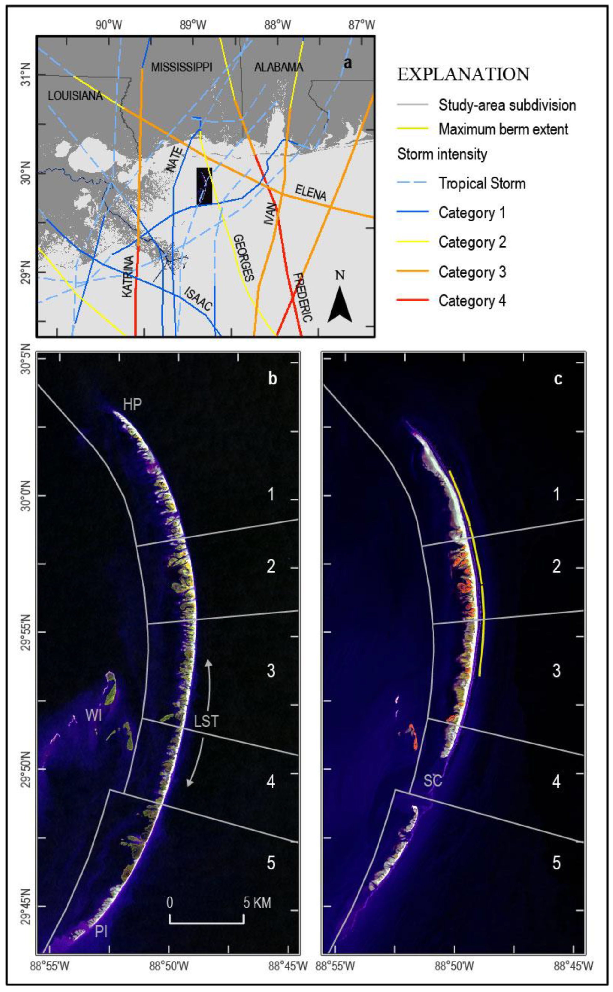
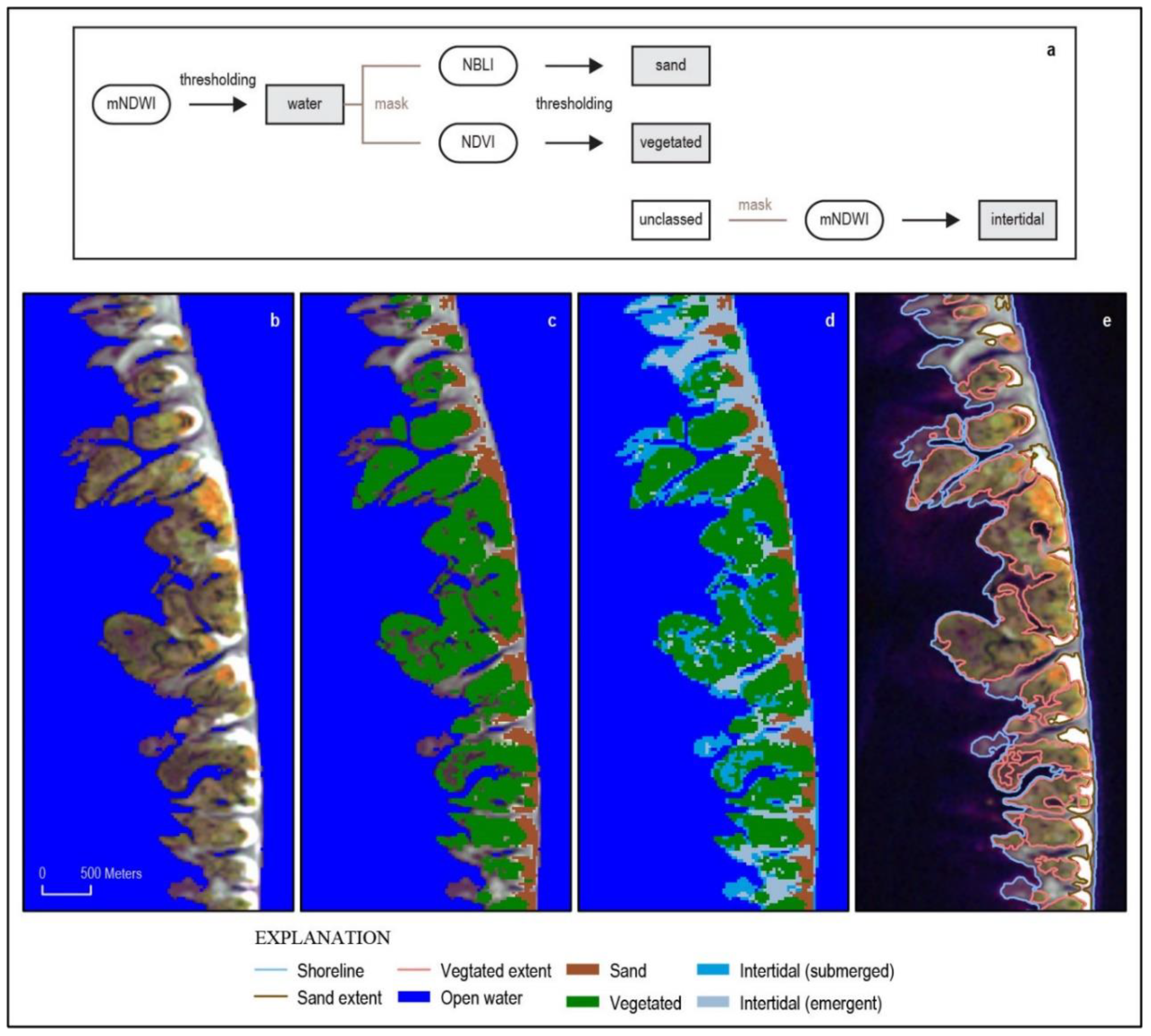
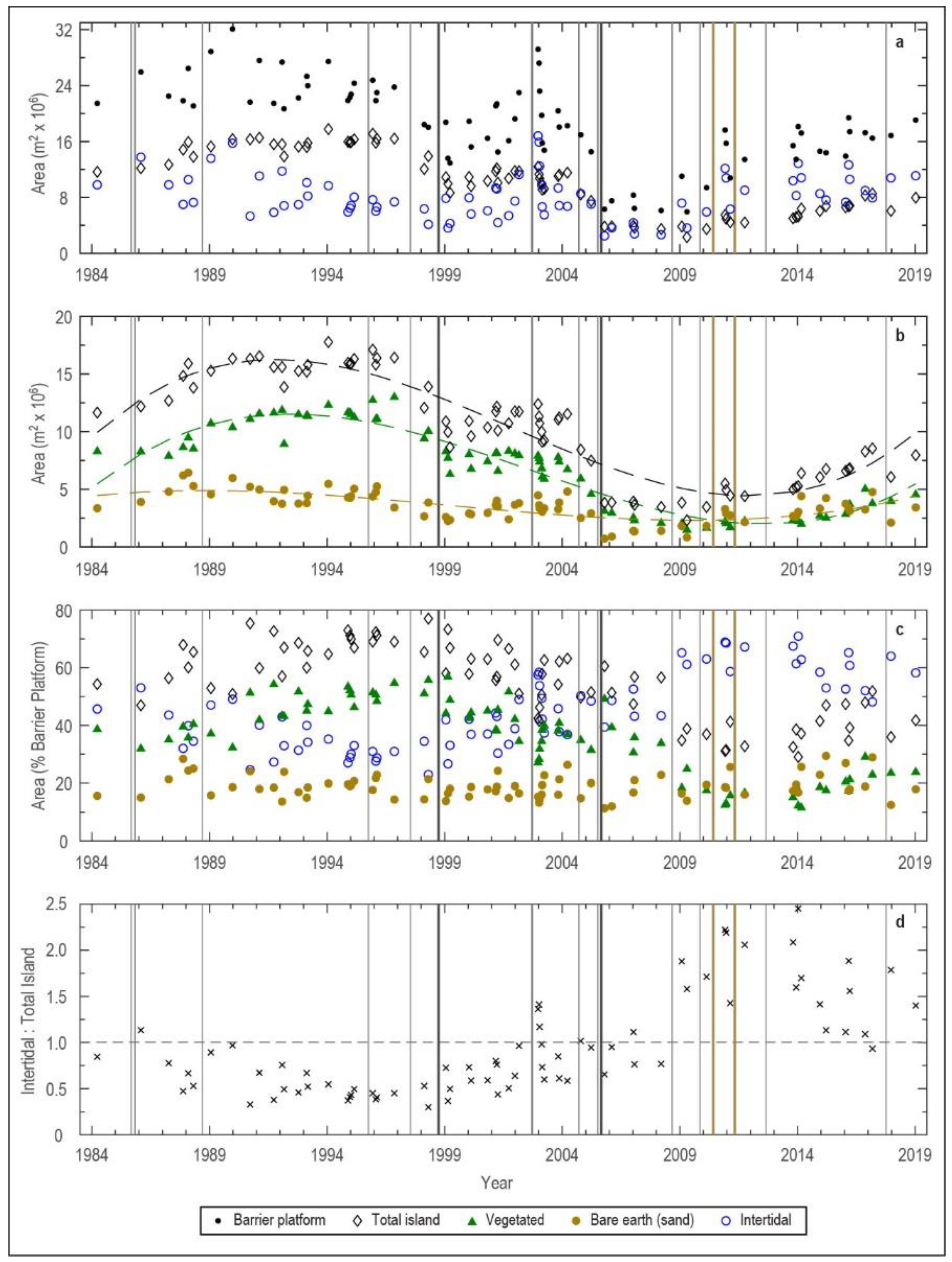
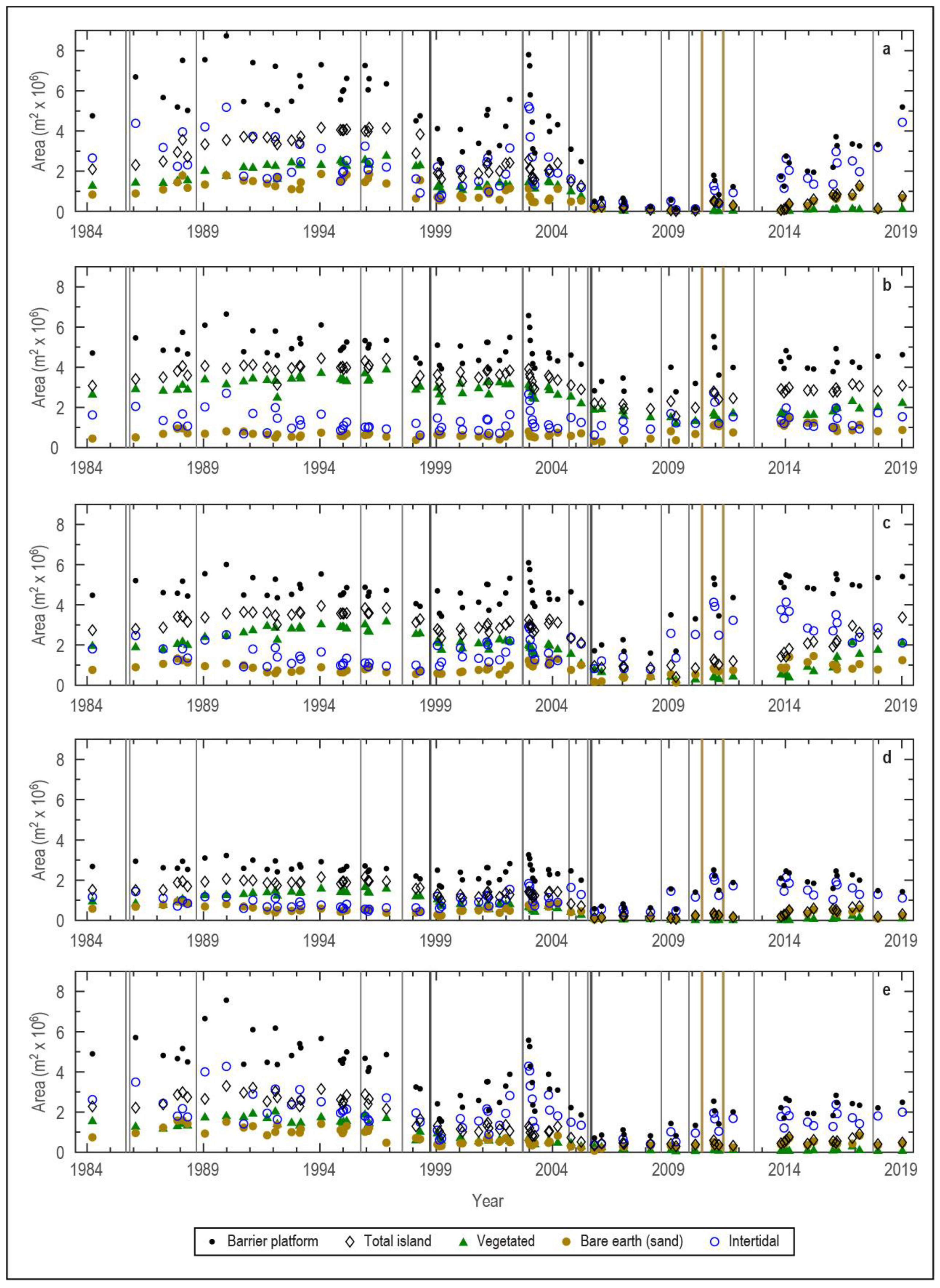
| Subarea | Description |
|---|---|
| 1 | Fragmented post-Hurricane Georges marsh platform (berm built on submerged barrier platform) |
| 2 | Persistent post-Hurricane Katrina marsh platform (berm built in front of or attached to emergent island) |
| 3 | Fragmented post-Hurricane Katrina marsh platform, north of longshore-transport (LST) nodal point (berm, if present, built attached to emergent island) |
| 4 | Persistent post-Hurricane Georges marsh platform, south of LST nodal point (south of berm emplacement) |
| 5 | Fragmented post-Hurricane Georges marsh platform, south of post-Hurricane Katrina Smack Channel Cut |
| Classed Data | Reference Dataset (NLCD) | Overall Accuracy 1 | Reference Dataset (BICM) | Overall Accuracy 1 | Overall Accuracy 2 |
|---|---|---|---|---|---|
| 17-November-2016 | NLCD 2016 | 69.3% | BICM 2016 | 74.0% | 61.8% |
| 18-January-2016 | NLCD 2016 | 80.3% | BICM 2016 | 71.0% | 61.0% |
| 24-October-2013 | NLCD 2013 | 71.7% | N/A | N/A | N/A |
| 03-October-2011 | NLCD 2011 | 78.3% | N/A | N/A | N/A |
| 30-January-2009 | NLCD 2008 | 55.7% | BICM 2008 | 70.3% | 66.5% |
| 18-October-2005 | NLCD 2006 | 51.0% | BICM 2005 | 50.0% | 40.8% |
| 15-October-2004 | NLCD 2004 | 57.3% | N/A | N/A | N/A |
| 31-March-2004 | N/A | N/A | BICM 2004 | 75.3% | 63% |
| 21-September-2001 | NLCD 2001 | 71.0% | N/A | N/A | N/A |
| 17-Febuary-1998 | N/A | N/A | BICM 1998 | 74.3% | 56.5% |
| Time Period | Description | Number of Images |
|---|---|---|
| 25-March-1984 to 22-April-1998 | Pre-Hurricane Georges 1 (14.1 years) | 27 |
| 10-January-1999 to 24-March-2005 | Pre-Hurricane Katrina 2 (6.2 years) | 23 |
| 18-October-2005 to 18-Febuary-2010 | Post-Hurricane Katrina 2 (4.3 years) | 8 |
| 3-December-2010 to 19-January-2019 | Post-berm construction 3 (8.1 years) | 17 |
| Subarea | Number of Transects | 1984–1998 | 1999–2005 | 2005–2010 | 2010–2019 |
|---|---|---|---|---|---|
| 1 | 33 | −1.2 ± 1.6 | 1.9 ± 19.7 | −115.8 ± 60.3 | 5.7 ± 12.2 |
| 2 | 19 | −3.2 ± 1.2 | −2.8 ± 1.7 | 7.8 ± 20 | −11.2 ± 4.8 |
| 3 | 25 | −3.6 ± 1.1 | −1.1 ± 5.9 | −16.8 ± 38.6 | −9.8 ± 5 |
| 4 | 18 | −5.5 ± 1.8 | −7.4 ± 7 | −58.6 ± 61.7 | −31.5 ± 14.3 |
| 5 | 37 | −13.9 ± 4.3 | −25.6 ± 23.6 | −116.2 ± 18.4 | −45.5 ± 24.3 |
Publisher’s Note: MDPI stays neutral with regard to jurisdictional claims in published maps and institutional affiliations. |
© 2021 by the authors. Licensee MDPI, Basel, Switzerland. This article is an open access article distributed under the terms and conditions of the Creative Commons Attribution (CC BY) license (https://creativecommons.org/licenses/by/4.0/).
Share and Cite
Bernier, J.C.; Miselis, J.L.; Plant, N.G. Satellite-Derived Barrier Response and Recovery Following Natural and Anthropogenic Perturbations, Northern Chandeleur Islands, Louisiana. Remote Sens. 2021, 13, 3779. https://doi.org/10.3390/rs13183779
Bernier JC, Miselis JL, Plant NG. Satellite-Derived Barrier Response and Recovery Following Natural and Anthropogenic Perturbations, Northern Chandeleur Islands, Louisiana. Remote Sensing. 2021; 13(18):3779. https://doi.org/10.3390/rs13183779
Chicago/Turabian StyleBernier, Julie C., Jennifer L. Miselis, and Nathaniel G. Plant. 2021. "Satellite-Derived Barrier Response and Recovery Following Natural and Anthropogenic Perturbations, Northern Chandeleur Islands, Louisiana" Remote Sensing 13, no. 18: 3779. https://doi.org/10.3390/rs13183779
APA StyleBernier, J. C., Miselis, J. L., & Plant, N. G. (2021). Satellite-Derived Barrier Response and Recovery Following Natural and Anthropogenic Perturbations, Northern Chandeleur Islands, Louisiana. Remote Sensing, 13(18), 3779. https://doi.org/10.3390/rs13183779


