Development of a Radar Reflector Kit for Older Adults to Use to Signal Their Location and Needs in a Large-Scale Earthquake Disaster
Abstract
1. Background and Purpose
1.1. Background
1.2. Purpose
2. Literature Review and Justification for the Study
2.1. Literature Review
2.2. Justification for the Study
3. Reflector Kit Development
3.1. SAR Satellite Imagery Parameters
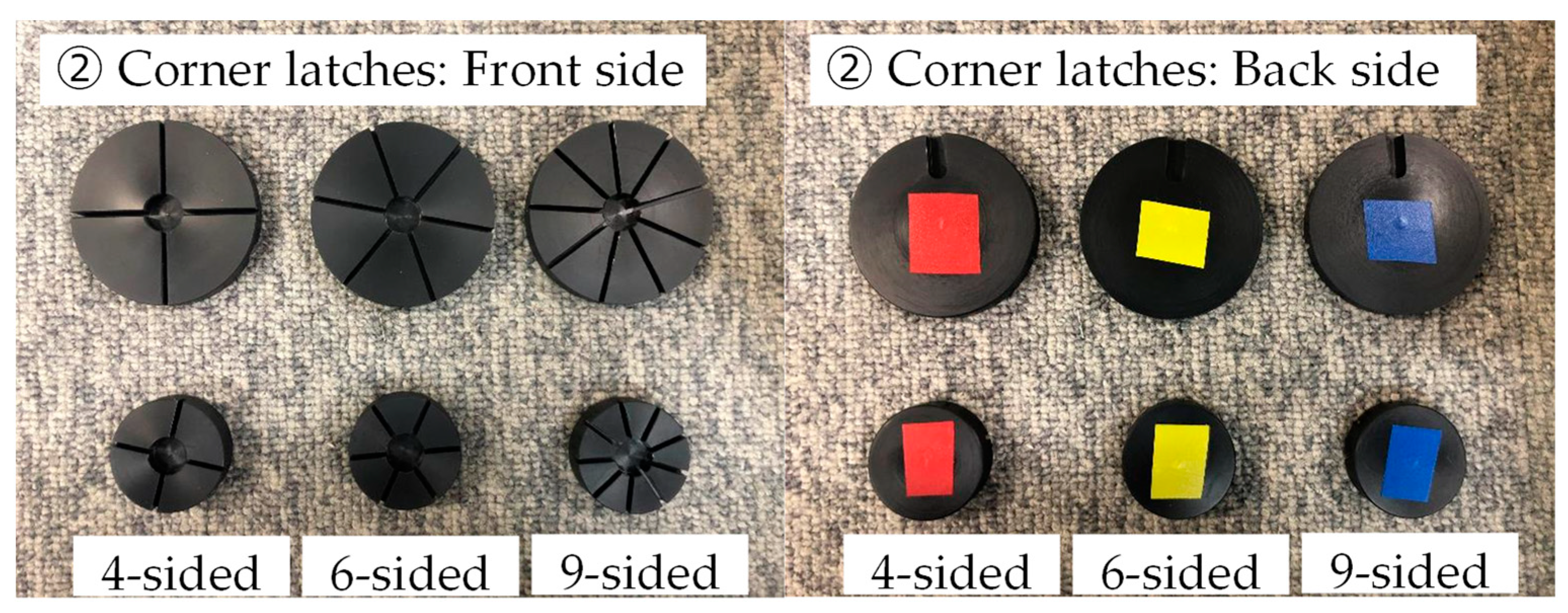
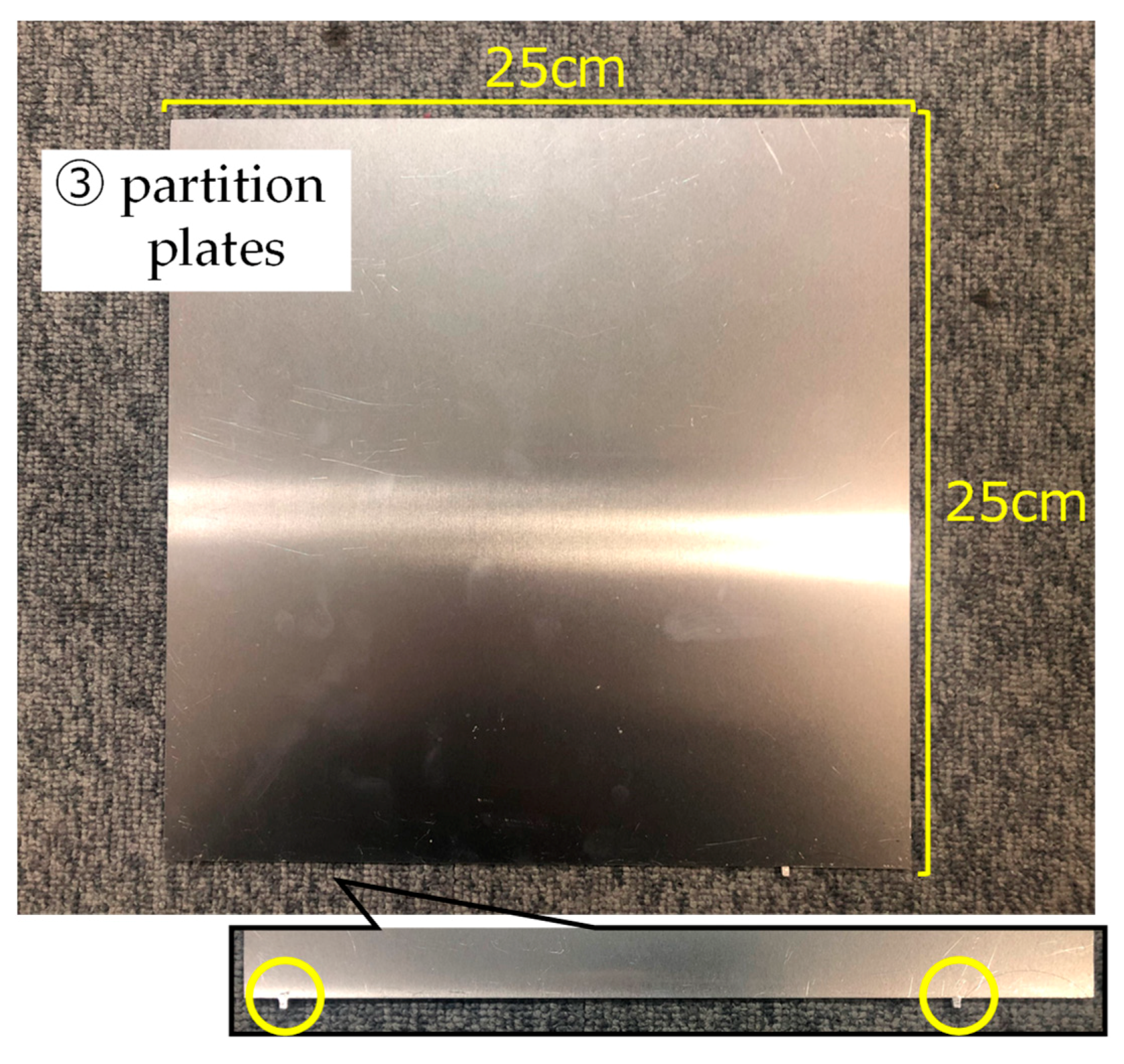
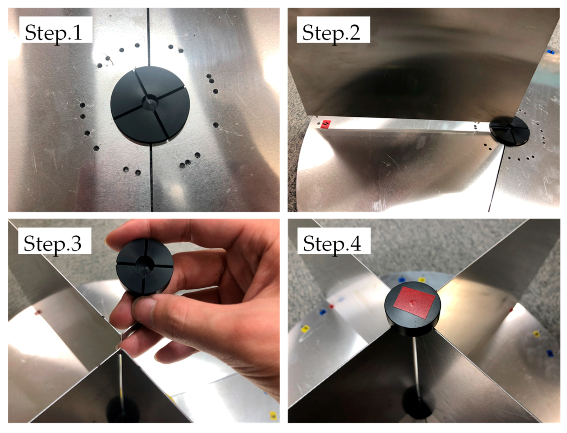
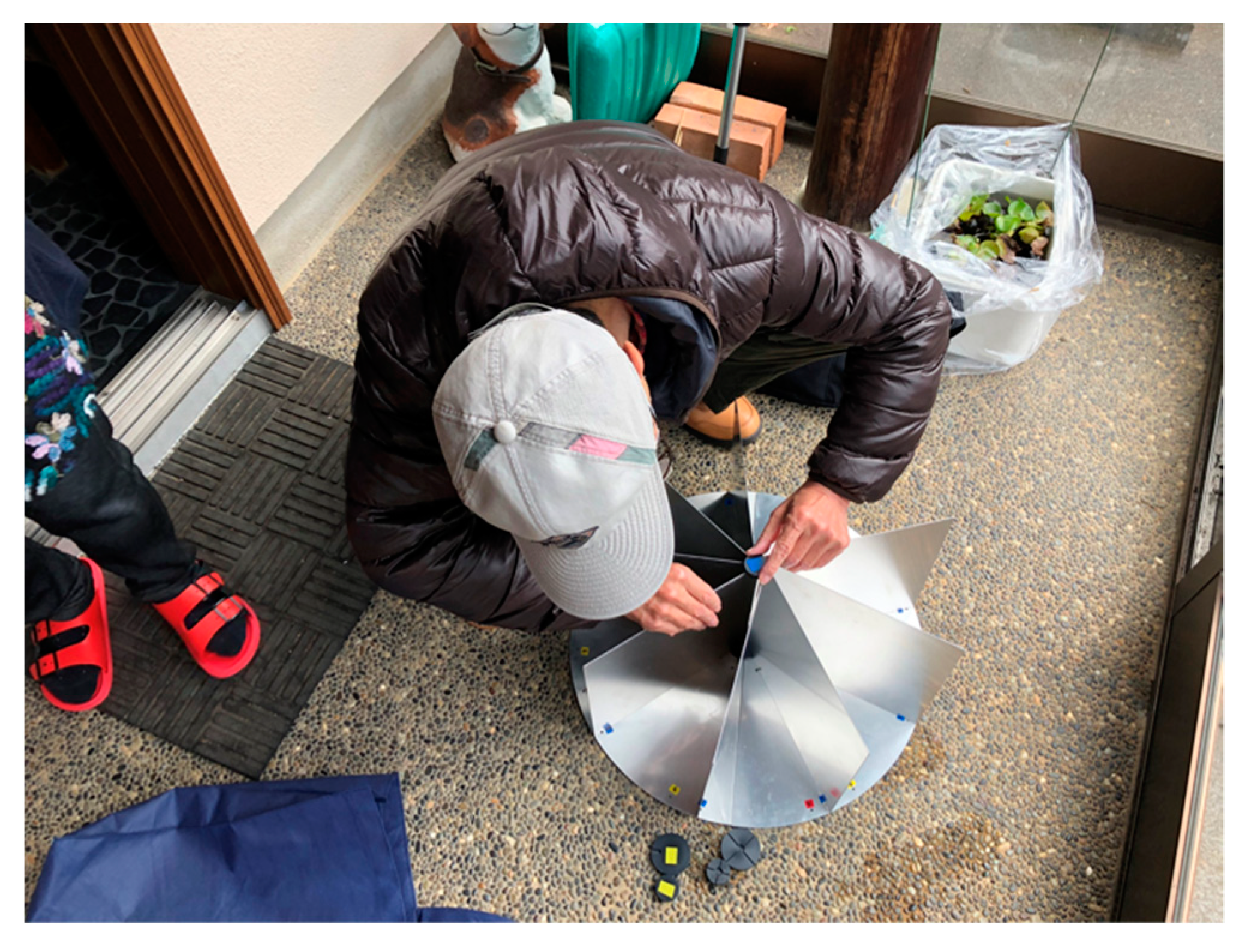
3.2. The Reflector Kit and Its Assembly
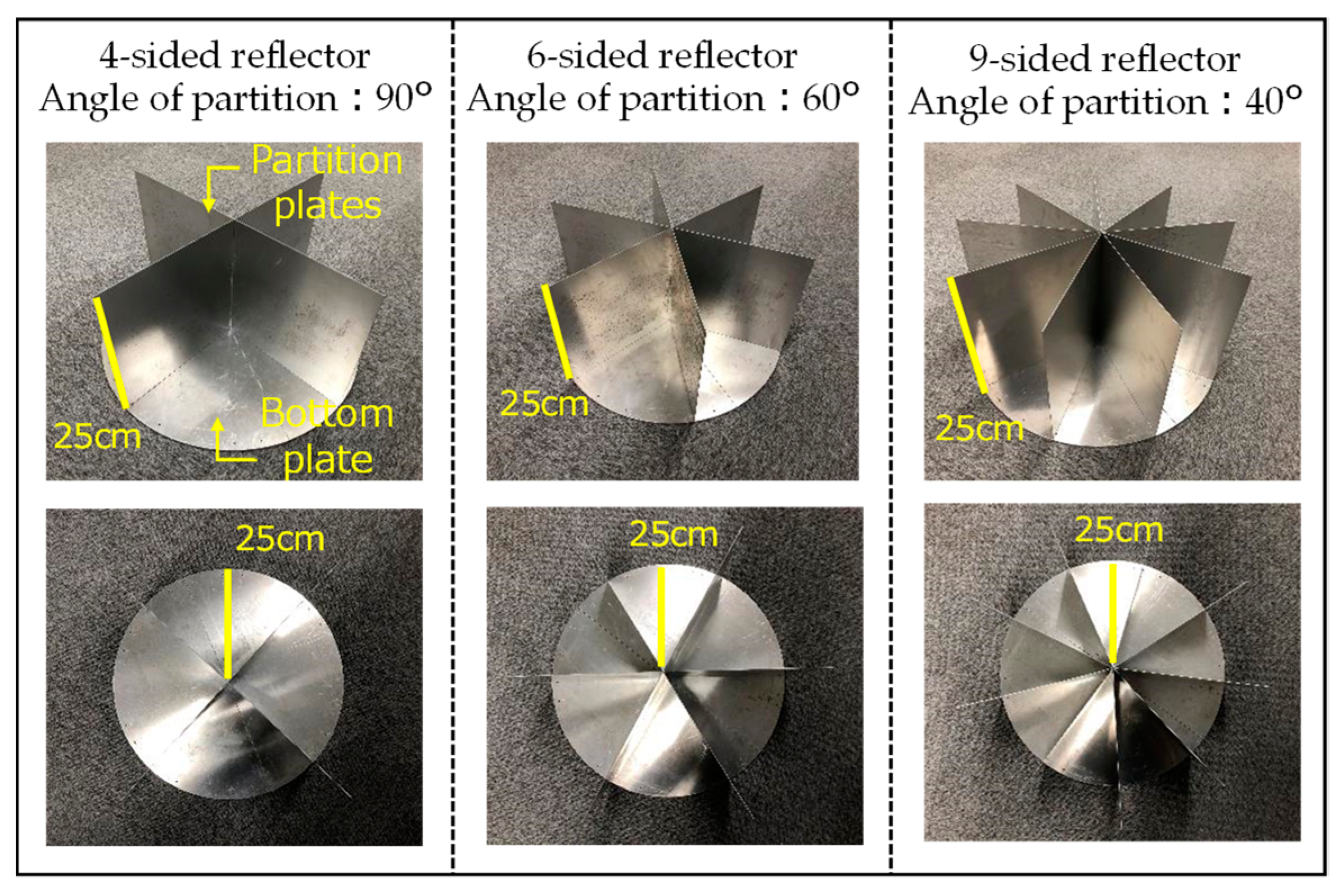
- Given that the reflector would be set up by a disaster victim, the size of the reflector needed to be as small as possible but still detectable in ASNARO-2 imagery.
- To make set-up as easy as possible, the shape of the reflector should make it detectable regardless of the direction of the satellite’s orbit during observations.
4. Reflector Detectability in ASNARO-2 Imagery
4.1. Testing the Reflector Kit Set-Up
4.2 Determining Reflector Detectability and Backscattering Coefficients
5. Radar Reflector Kit Feedback Survey
5.1. Survey Items and Data Collection
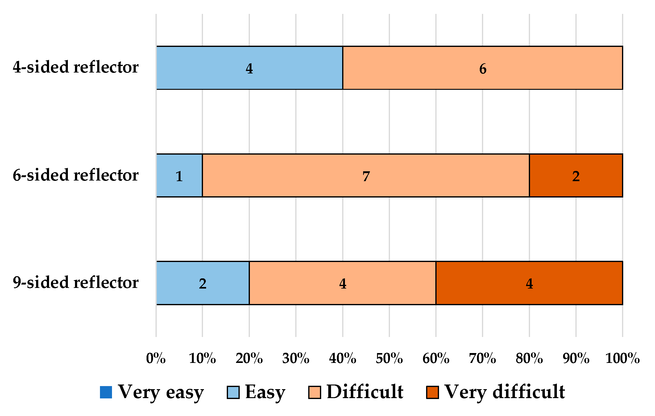
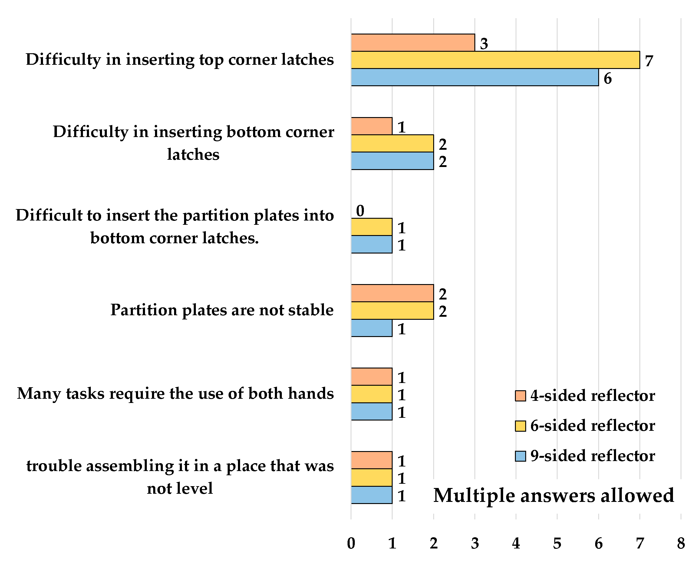
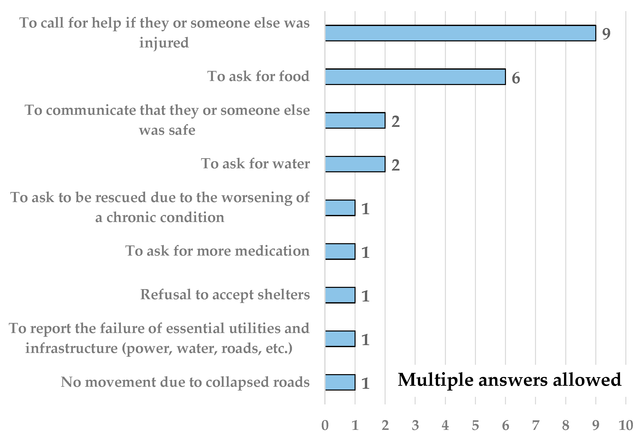
5.2. Survey Results
6. Conclusions and Further Issues
Author Contributions
Funding
Data Availability Statement
Conflicts of Interest
References
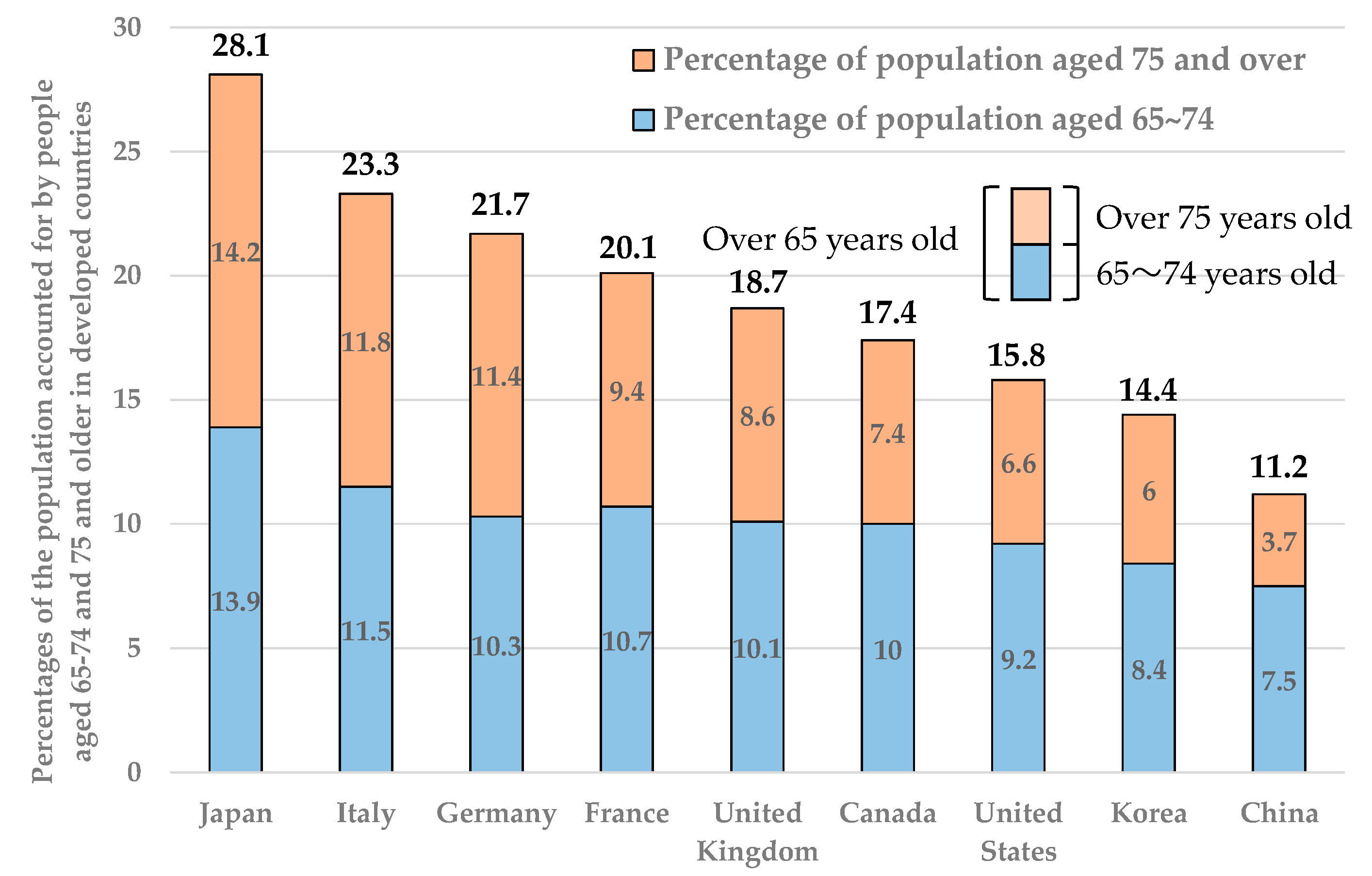
- Statistics Bureau of Japan. 5. International Comparisons of Statistics for the Elderly. Available online: https://www.stat.go.jp/data/topics/topi1135.html (accessed on 1 January 2021).
- Cabinet Office Japan Disaster Management Information Page. Measures for People Requiring Assistance during a Disaster. Available online: http://www.bousai.go.jp/taisaku/hisaisyagyousei/youengosya/ (accessed on 1 January 2021).
- Morisaki, Y.; Fujiu, M.; Furuta, R.; Takayama, J. Evaluation of methods of understanding vulnerable people’s needs after large scale earthquake disaster. J. Japan Soc. Civil Eng. D3 2021, 76, 259–266. (In Japanese) [Google Scholar]
- Reflector-Identification System. Japanese Patent Application No. 2020-128207, 2 August 2019. patent pending.
- Miura, H.; Midorikawa, S.; Matsuoka, M. Accuracy improvement of building damage detection using high-resolution SAR images observed from different directions. J. Japan Assoc. Earthq. Eng. 2015, 15, 390–403. (In Japanese) [Google Scholar]
- Hasekura, K.; Gokon, H.; Koshimura, S.; Meguro, K. Verification of a method for determining analysis area of building damage in a tsunami affected area by using L-band SAR data. J. Soc. Saf. Sci. 2016, 29, 47–52. (In Japanese) [Google Scholar]
- Sato, H.; Miyahara, B.; Okatani, T.; Koarai, M.; Sekiguchi, T.; Yagi, H. Detection of landslide surface deformation triggered by the 2011 off the Pacific coast of Tohoku earthquake using InSAR image. J. Jpn. Landslide Soc. 2014, 51, 41–49. (In Japanese) [Google Scholar] [CrossRef][Green Version]
- Li, C.; Zhang, G.; Shan, X.; Zhao, D.; Li, Y.; Huang, Z.; Jia, R.; Li, J.; Nie, J. Surface Rupture Kinematics and Coseismic Slip Distribution during the 2019 Mw7.1 Ridgecrest, California Earthquake Sequence Revealed by SAR and Optical Images. Remote Sens. 2020, 12, 3883. [Google Scholar] [CrossRef]
- Takahashi, T.; Usui, T.; Fujishima, T.; Ohki, M.; Sano, H.; Kosada, H. Education using ALOS-2 with easy-to-make reflectors. J. Remote Sens. Soc. Jpn. 2016, 36, 360–366. (In Japanese) [Google Scholar]
- Suzuki, H. Studies on the development of citizen participation geoglyphs production programs using earth observation satellite. Bull. Kanazawa Coll. Art 2016, 60, 33–58. (In Japanese) [Google Scholar]
- Jauvin, M.; Yan, Y.; Trouvé, E.; Fruneau, B.; Gay, M.; Girard, B. Integration of Corner Reflectors for the Monitoring of Mountain Glacier Areas with Sentinel-1 Time Series. Remote Sens. 2019, 11, 988. [Google Scholar] [CrossRef]
- Schmidt, K.; Reimann, J.; Tous Ramon, N.; Schwerdt, M. Geometric Accuracy of Sentinel-1A and 1B Derived from SAR Raw Data with GPS Surveyed Corner Reflector Positions. Remote Sens. 2018, 10, 523. [Google Scholar] [CrossRef]
- Osaragi, T.; Oki, T. A real time synchronous system for collecting, sharing, and utilizing disaster information. J. Archit. Plan. 2017, 82, 2451–2459. (In Japanese) [Google Scholar] [CrossRef][Green Version]
- Hiruta, M.; Tsuruoka, Y.; Tada, Y. A proposal of a disaster information sharing system. IEICE Tech. Rep. 2012, 2, 5–8. (In Japanese) [Google Scholar]
- Jeong, B.; Zama, S.; Takizawa, O.; Endo, M.; Shibayama, A. Development of a disaster damage information collecting system using cellular phone. J. Japan Assoc. Earthq. Eng. 2009, 9, 2_102–2_112. (In Japanese) [Google Scholar]
- Sugii, K.; Sekizawa, A.; Okabe, H.; Endo, M.; Zama, S.; Araiba, K. Necessity of structuring an effective scheme of acquiring disaster information by fire departments just after an earthquake. J. Soc. Saf. Sci. 2008, 10, 89–96. (In Japanese) [Google Scholar]
- Remote Sensing Technology Center of Japan: ASNARO-2. Available online: https://www.restec.or.jp/satellite/asnaro-2 (accessed on 1 January 2021).
- Kanazawa City: Population/Number of Households (Updated Monthly). Available online: https://www4.city.kanazawa.lg.jp/11018/toukeidatasyu/jinnkousetaisu.html (accessed on 1 January 2021).

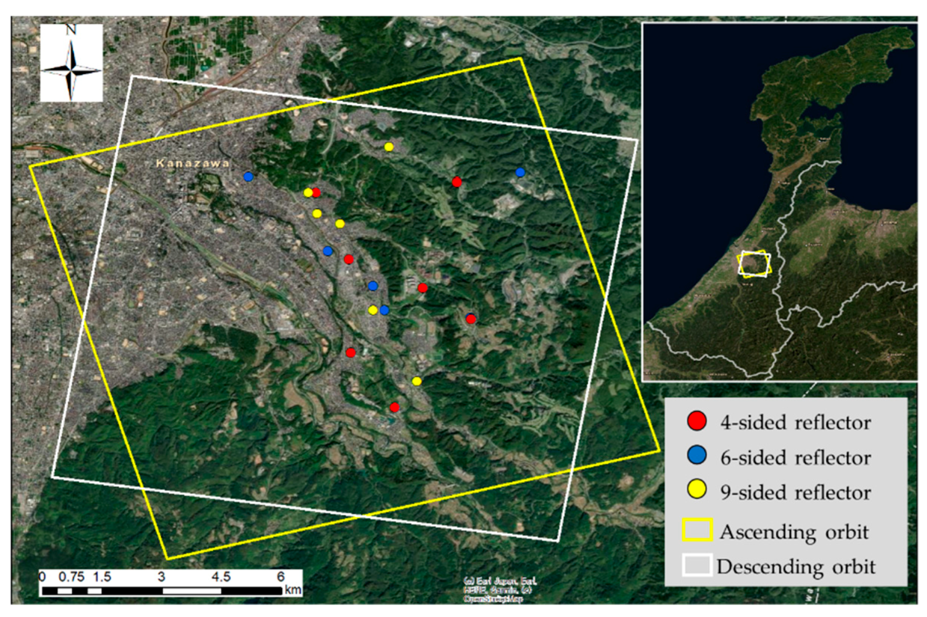
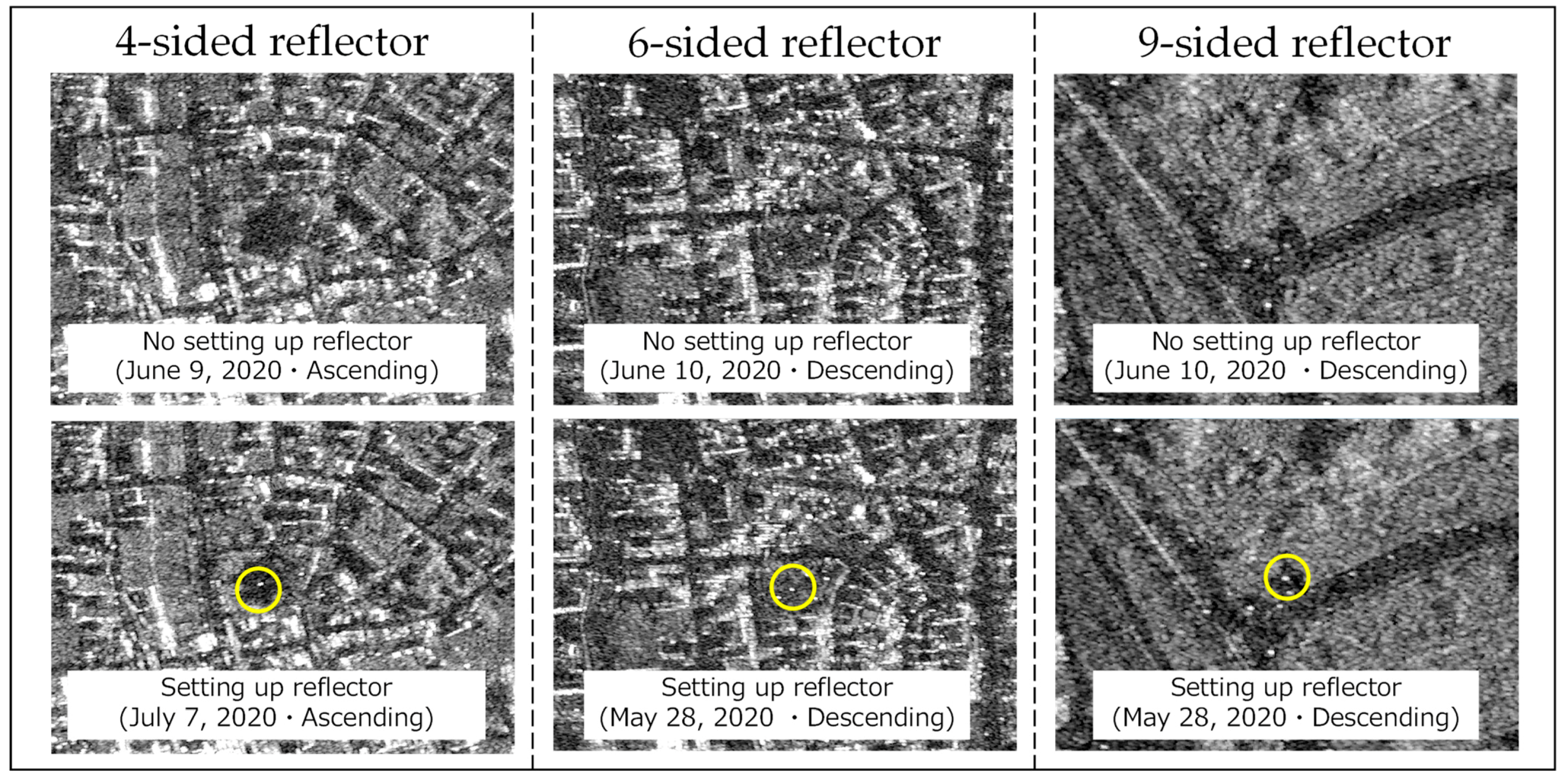
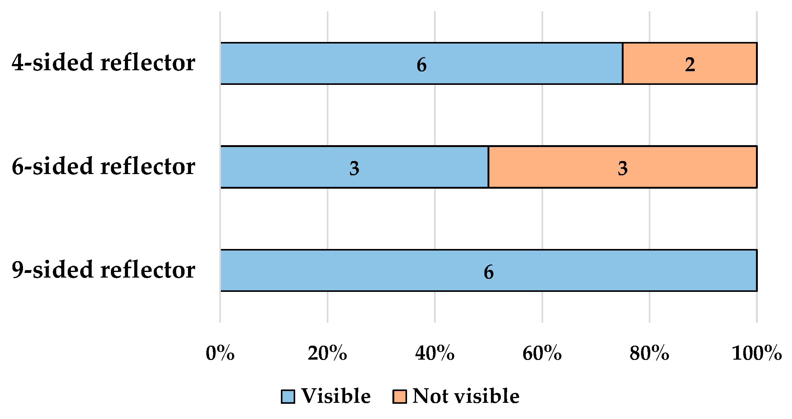
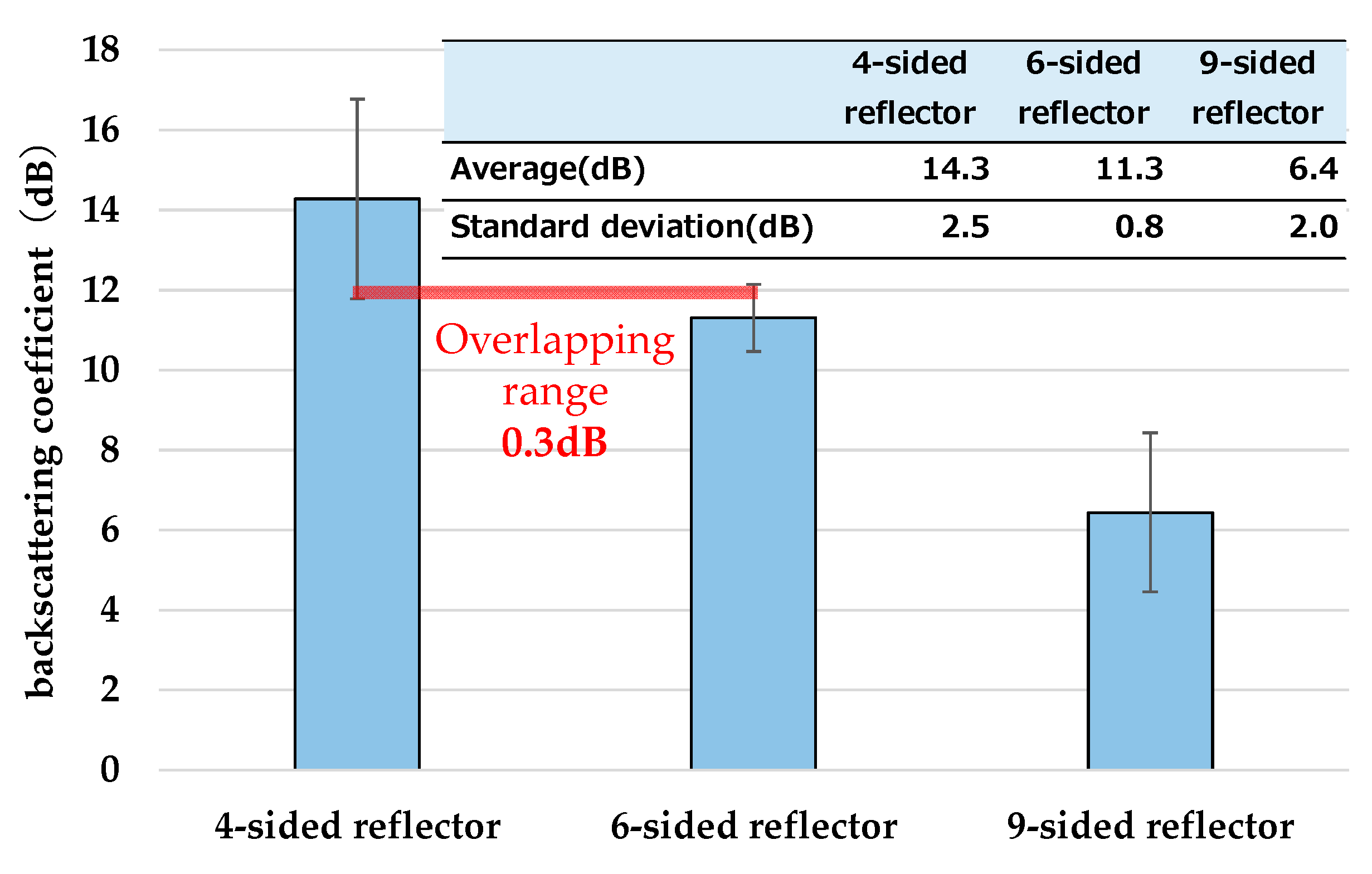
| Launch | 18 January 2018 Launched by Epsilon Rocket (JAPAN) |
|---|---|
| Start of service | 3 September 2018 |
| Mass | 570 kg |
| SAR sensor | X-band Parabola SAR |
| Collection mode: Resolution (Level 1.1) */Scene Size – Spotlight-1 (1.0): 1.0 × 1.0 m/10 × 10 km Spotlight-2 (1.0): 1.0 × 1.0 m **/10 × 10 km Stripmap (2.0): 2.0 × 2.0 m/12 × 12 up to 800 km – ScanSAR (16.0): 16.0 × 16.0 m/50 × 50 up to 800 km (*) At 35° off-nadir angle (**) Theoretical value: 0.5 m | |
| Orbit | Sun Synchronous Orbit Alt: Approx. 500 km |
| In the Park or Greenspace | Walkways | Roadside | |
|---|---|---|---|
| 4-sided reflector | 2 | 3 | 3 |
| 6-sided reflector | 4 | 1 | 1 |
| 9-sided reflector | 2 | 1 | 3 |
| Personal characteristics | Age |
| Gender | |
| Number of people in their household | |
| Medical conditions | |
| Through assembly experiments of reflector kits | Ease of assembly ratings |
| Reasons indicated for rating kit assembly as difficult. | |
| Participants’ ideas of needs they made want to communicate to response teams outside the disaster area. | |
| Sensitivity to reflector kit |
| Age | Gender | Number of Family | 1. Conditions | 2. Conditions | ||||
|---|---|---|---|---|---|---|---|---|
| Disease Name | Attending Hospital | Frequency by Month | Disease Name | Attending Hosipital | Frequency by Month | |||
| 73 | Male | 3 | Glaucoma | Yes | 0.5 | |||
| 65 | Male | 1 | - | |||||
| 71 | Female | 1 | High blood pressure | Yes | 1 | |||
| 72 | Male | 2 | Gout | Yes | 0.5 | |||
| 72 | Female | 4 | Osteoporosis | Yes | 0.5 | |||
| 73 | Male | 2 | Chronic gastritis | Yes | 1 | Lumbago | Yes | 8 |
| 66 | Male | 2 | High blood pressure | Yes | 1 | Gout | Yes | 1 |
| 62 | Male | 1 | Hyperuricemia | Yes | 1 | Cholesterinemia | ||
| 69 | Female | 2 | Gonarthrosis | Yes | 2 | |||
| 60 | Female | 1 | - | |||||
Publisher’s Note: MDPI stays neutral with regard to jurisdictional claims in published maps and institutional affiliations. |
© 2021 by the authors. Licensee MDPI, Basel, Switzerland. This article is an open access article distributed under the terms and conditions of the Creative Commons Attribution (CC BY) license (https://creativecommons.org/licenses/by/4.0/).
Share and Cite
Morisaki, Y.; Fujiu, M.; Furuta, R.; Takayama, J. Development of a Radar Reflector Kit for Older Adults to Use to Signal Their Location and Needs in a Large-Scale Earthquake Disaster. Remote Sens. 2021, 13, 1883. https://doi.org/10.3390/rs13101883
Morisaki Y, Fujiu M, Furuta R, Takayama J. Development of a Radar Reflector Kit for Older Adults to Use to Signal Their Location and Needs in a Large-Scale Earthquake Disaster. Remote Sensing. 2021; 13(10):1883. https://doi.org/10.3390/rs13101883
Chicago/Turabian StyleMorisaki, Yuma, Makoto Fujiu, Ryoichi Furuta, and Junichi Takayama. 2021. "Development of a Radar Reflector Kit for Older Adults to Use to Signal Their Location and Needs in a Large-Scale Earthquake Disaster" Remote Sensing 13, no. 10: 1883. https://doi.org/10.3390/rs13101883
APA StyleMorisaki, Y., Fujiu, M., Furuta, R., & Takayama, J. (2021). Development of a Radar Reflector Kit for Older Adults to Use to Signal Their Location and Needs in a Large-Scale Earthquake Disaster. Remote Sensing, 13(10), 1883. https://doi.org/10.3390/rs13101883


