Assessing Soil Erosion Hazards Using Land-Use Change and Landslide Frequency Ratio Method: A Case Study of Sabaragamuwa Province, Sri Lanka


Abstract

1. Introduction
2. Materials and Methods
2.1. Study Area
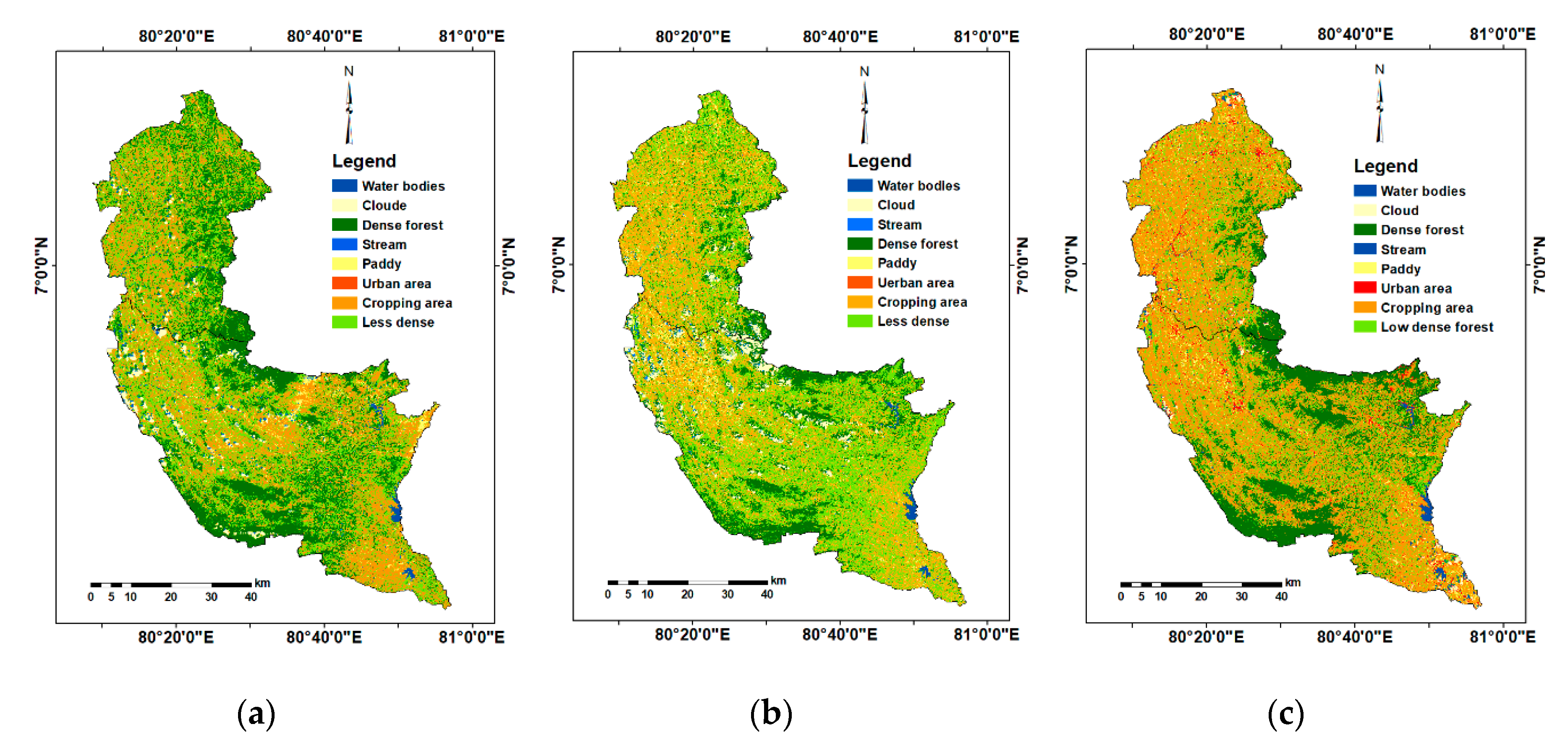
2.2. Remote Sensing Data and Image Processing
2.3. Land-Use Land-Cover Change
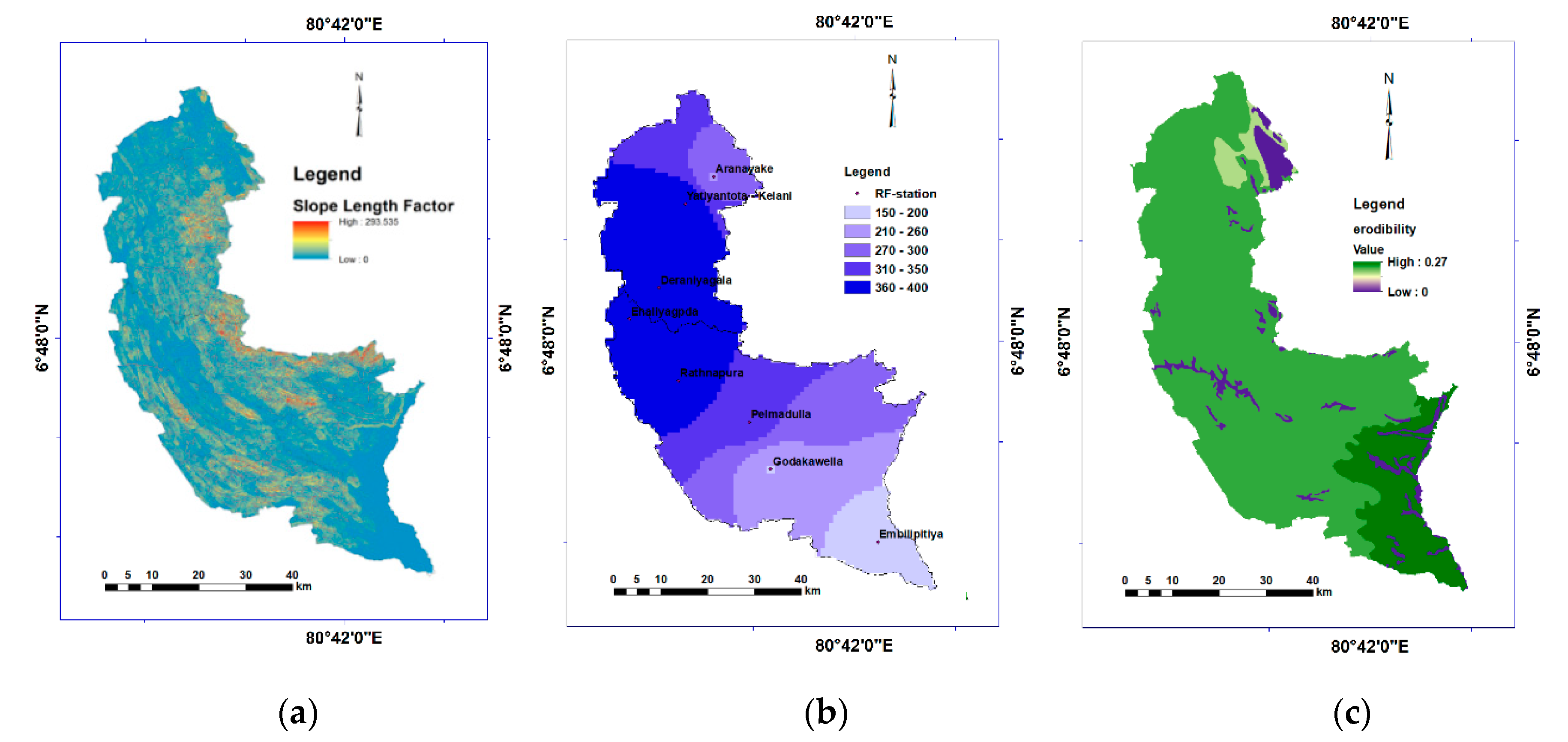
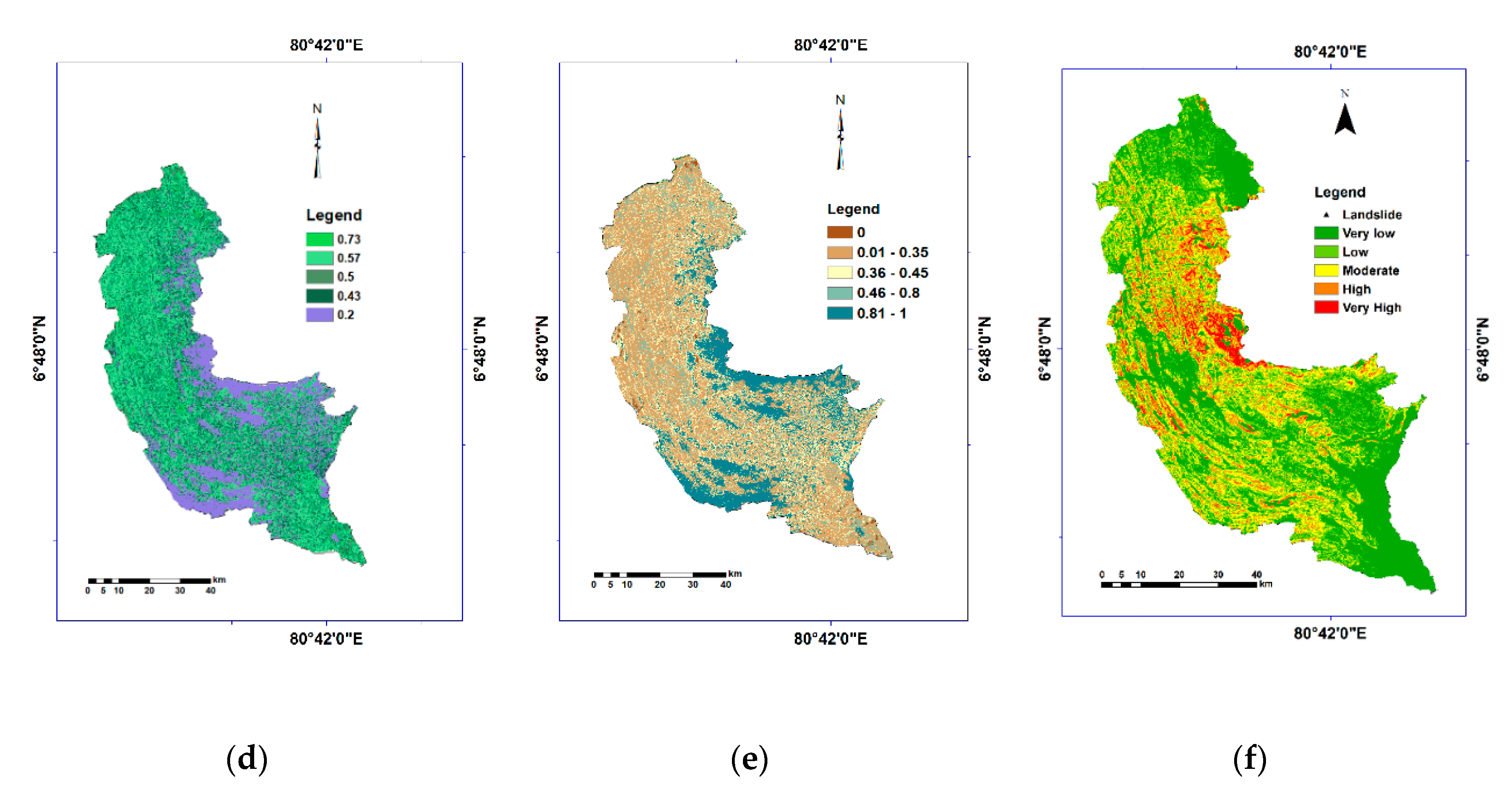
2.4. Soil Erosion Assessment
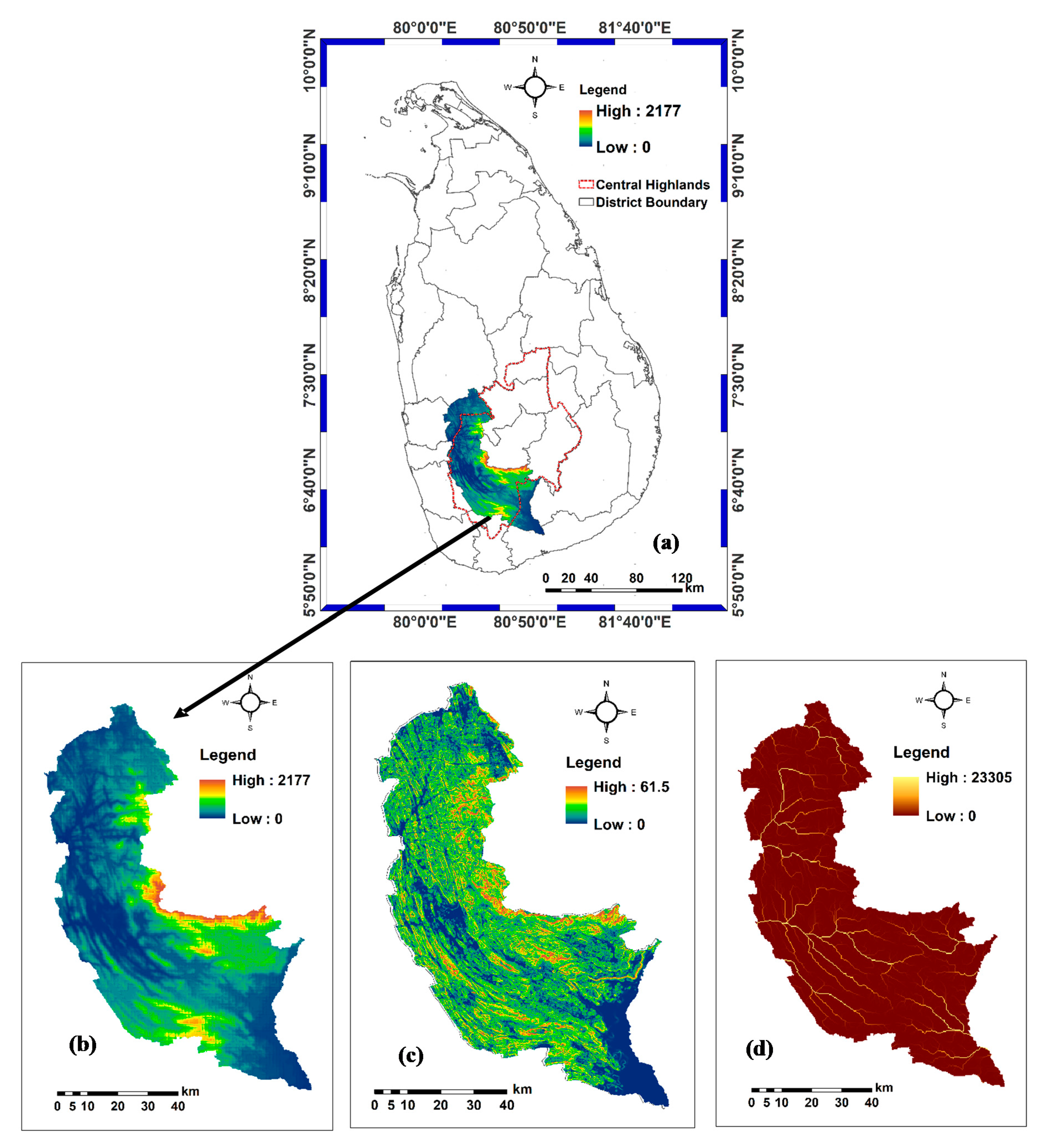
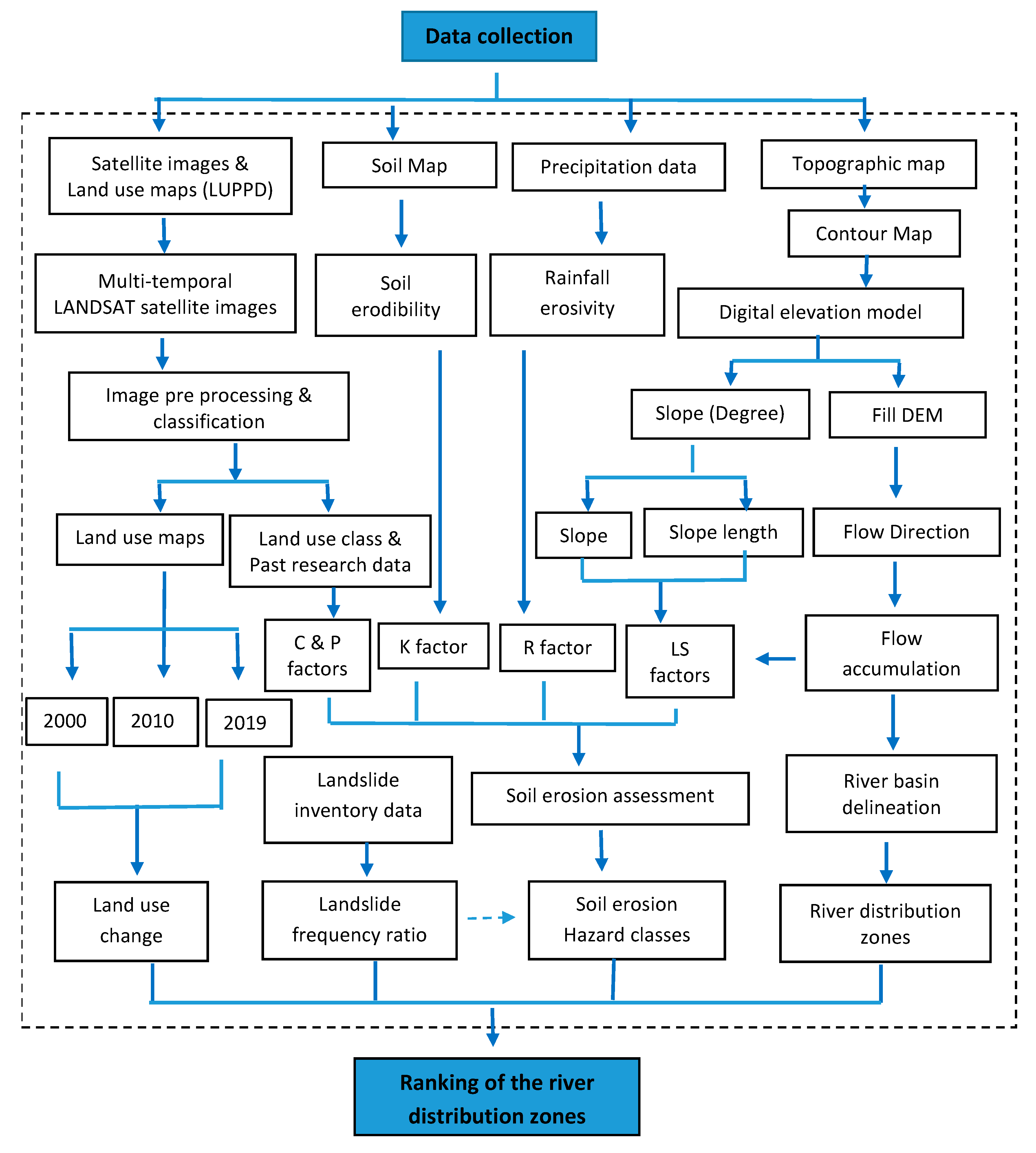
2.5. Data Processing for Factor Generation
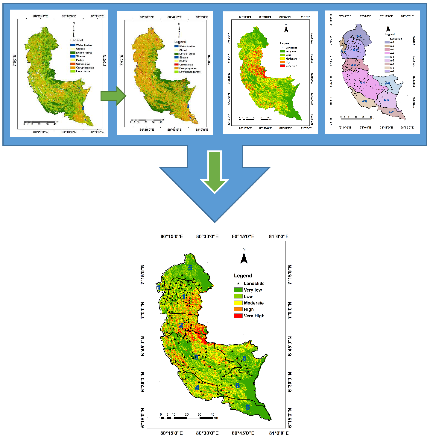
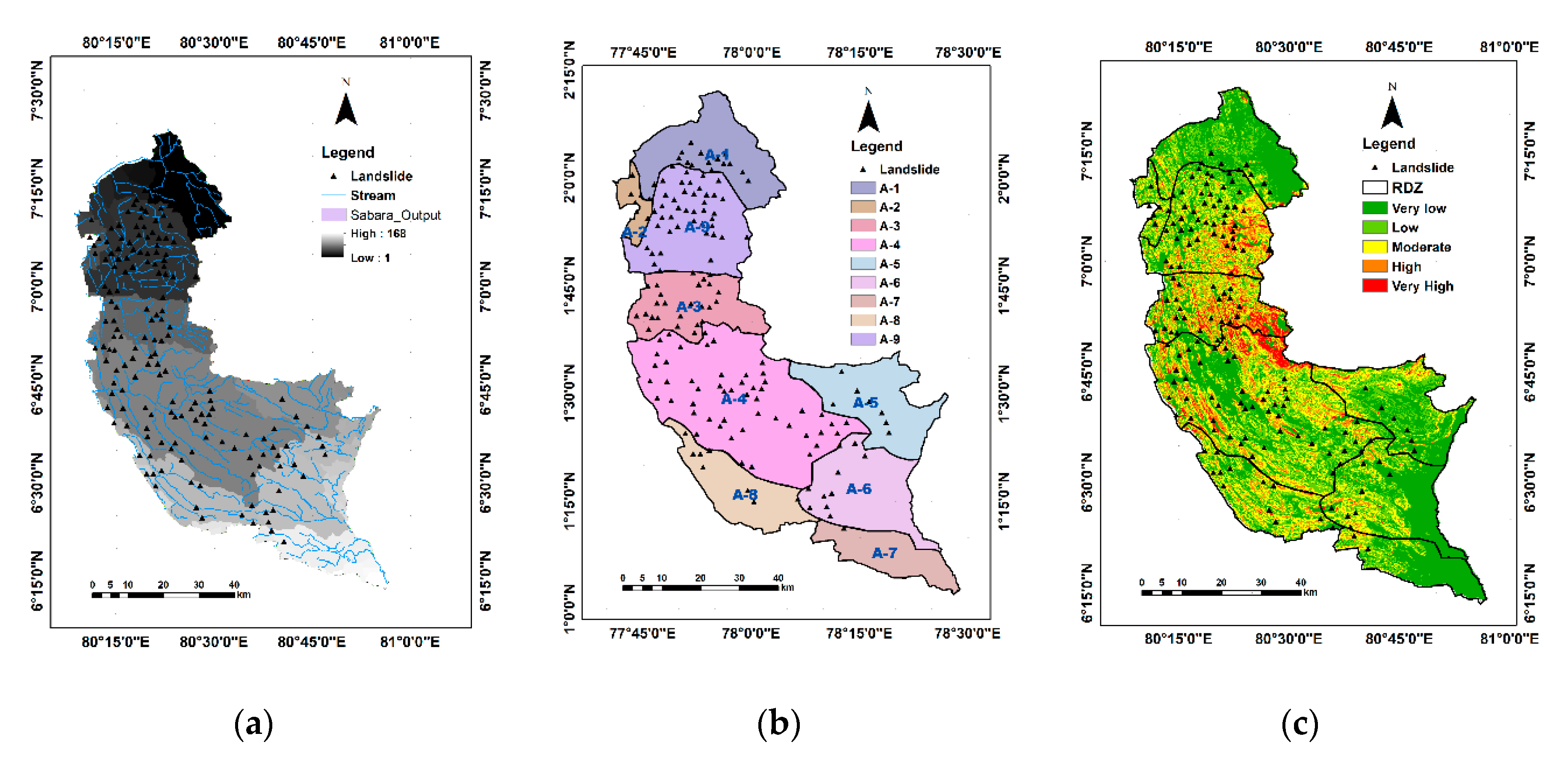
2.6. Landslide Inventory Map and Frequency Ratio Calculation
3. Results
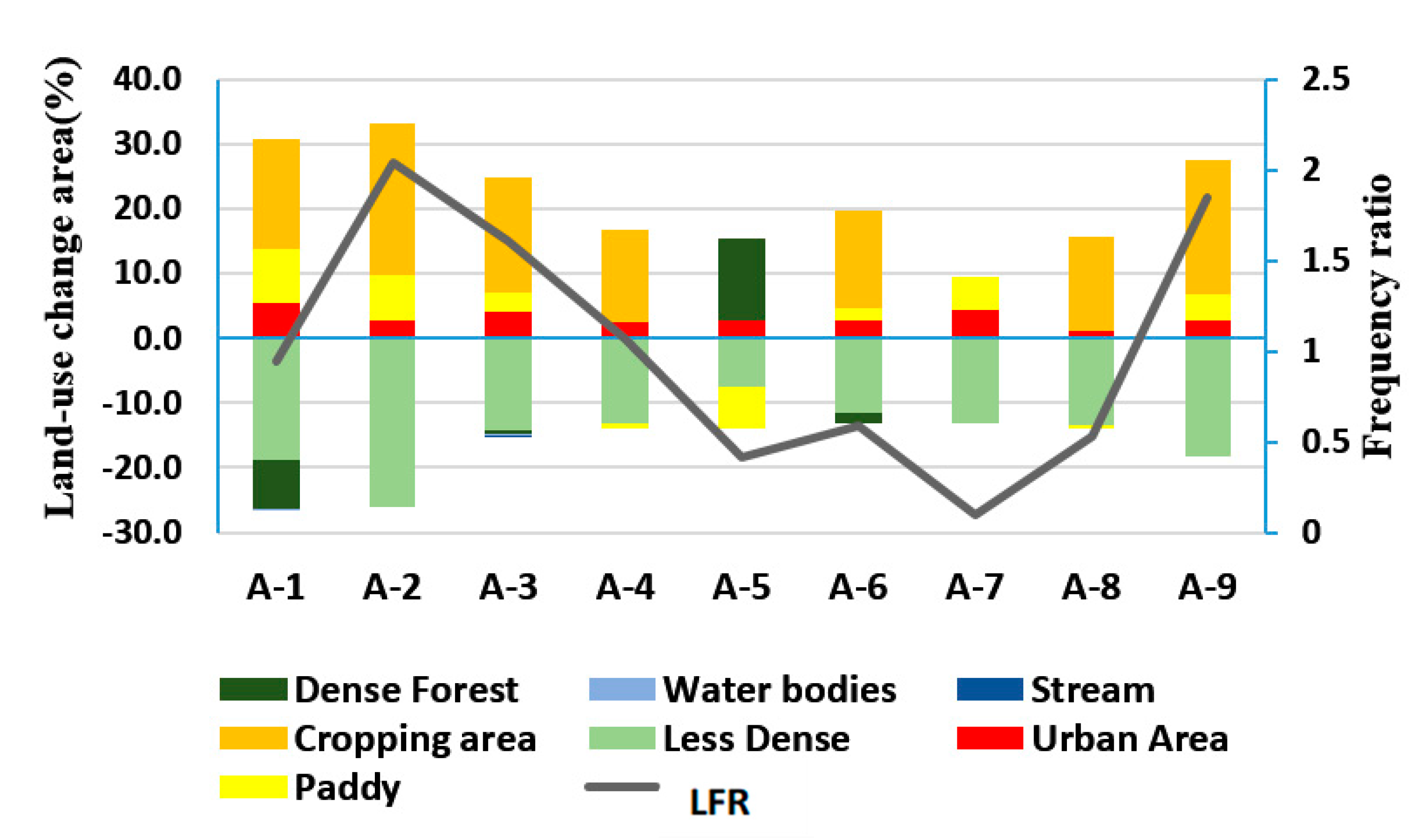
3.1. LULC Change
3.2. Soil Erosion Hazard
3.3. Land-Use Change and Its Correlation with Landslides
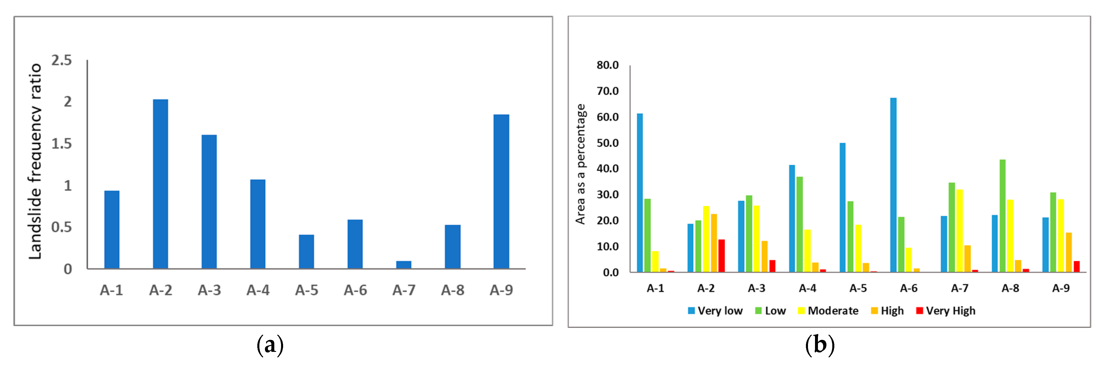
3.4. Soil Erosion Hazard and Its Correlation with Landslide
4. Discussion
5. Conclusions
Supplementary Materials
Author Contributions
Funding
Acknowledgments
Conflicts of Interest
References
- Panagos, P.; Borrelli, P.; Meusburger, K.; Yu, B.; Klik, A.; Lim, K.J.; Yang, J.E.; Ni, J.; Miao, C.; Chattopadhyay, N. Global rainfall erosivity assessment based on high-temporal resolution rainfall records. Sci. Rep. 2017, 7, 4175. [Google Scholar] [CrossRef]
- Poesen, J. Soil erosion in the Anthropocene: Research needs. Earth Surf. Process. Landf. 2018, 43, 64–84. [Google Scholar] [CrossRef]
- Lal, R. Soil degradation by erosion. Land Degrad. Dev. 2001, 12, 519–539. [Google Scholar] [CrossRef]
- Segura, C.; Sun, G.; Mcnulty, S.; Zhang, Y. Potential impacts of climate change on soil erosion vulnerability across the conterminous United States. J. Soil Water Conserv. 2014, 69, 171–181. [Google Scholar] [CrossRef]
- Puente, C.; Olague, G.; Trabucchi, M.; Arjona-Villicaña, P.D.; Soubervielle-Montalvo, C. Synthesis of Vegetation Indices Using Genetic Programming for Soil Erosion Estimation. Remote Sens. 2019, 11, 156. [Google Scholar] [CrossRef]
- Morgan, R.P.C. Soil Erosion and Conservation; John Wiley & Sons: Oxford, UK, 2009. [Google Scholar]
- Broz, B.; Pfost, D.L.; Thompson, A.L. Controlling Runoff and Erosion at Urban Construction Sites; Extension publications (MU): University of Missouri: Columbia, MO, USA, 2003. [Google Scholar]
- Gayen, A.; Pourghasemi, H.R.; Saha, S.; Keesstra, S.; Bai, S. Gully erosion susceptibility assessment and management of hazard-prone areas in India using different machine learning algorithms. Sci. Total Environ. 2019, 668, 124–138. [Google Scholar] [CrossRef]
- Poesen, J.; Vandekerckhove, L.; Nachtergaele, J.; Oostwoud Wjdenes, D.; Verstraetraeten, G.; Wesemael, V. Gully Erosion in Dryland Environments; John Willey & Sons Ltd.: West Sussex, UK, 2002. [Google Scholar]
- Burt, T.; Weerasinghe, K. Rainfall distributions in Sri Lanka in time and space: An analysis based on daily rainfall data. Climate 2014, 2, 242–263. [Google Scholar] [CrossRef]
- Ighodaro, I.D.; Lategan, F.S.; Yusuf, S.F. The impact of soil erosion on agricultural potential and performance of Sheshegu community farmers in the Eastern Cape of South Africa. J. Agric. Sci. 2013, 5, 140. [Google Scholar] [CrossRef]
- Fayas, C.M.; Abeysingha, N.S.; Nirmanee, K.G.S.; Samaratunga, D.; Mallawatantri, A. Soil loss estimation using rusle model to prioritize erosion control in KELANI river basin in Sri Lanka. Int. Soil Water Conserv. Res. 2019, 7, 130–137. [Google Scholar] [CrossRef]
- Abdulkareem, J.; Pradhan, B.; Sulaiman, W.; Jamil, N. Prediction of spatial soil loss impacted by long-term land-use/land-cover change in a tropical watershed. Geosci. Front. 2019, 10, 389–403. [Google Scholar] [CrossRef]
- Persichillo, M.G.; Bordoni, M.; Meisina, C. The role of land use changes in the distribution of shallow landslides. Sci. Total Environ. 2017, 574, 924–937. [Google Scholar] [CrossRef] [PubMed]
- Pradhan, B.; Chaudhari, A.; Adinarayana, J.; Buchroithner, M.F. Soil erosion assessment and its correlation with landslide events using remote sensing data and GIS: A case study at Penang Island, Malaysia. Environ. Monit. Assess. 2012, 184, 715–727. [Google Scholar] [CrossRef] [PubMed]
- Ganasri, B.; Ramesh, H. Assessment of soil erosion by RUSLE model using remote sensing and GIS-A case study of Nethravathi Basin. Geosci. Front. 2016, 7, 953–961. [Google Scholar] [CrossRef]
- Leh, M.; Bajwa, S.; Chaubey, I. Impact of land use change on erosion risk: An integrated remote sensing, geographic information system and modeling methodology. Land Degrad. Dev. 2013, 24, 409–421. [Google Scholar] [CrossRef]
- Nampak, H.; Pradhan, B.; Mojaddadi Rizeei, H.; Park, H.J. Assessment of land cover and land use change impact on soil loss in a tropical catchment by using multitemporal SPOT-5 satellite images and Revised Universal Soil Loss Equation model. Land Degrad. Dev. 2018, 29, 3440–3455. [Google Scholar] [CrossRef]
- Rizeei, H.M.; Saharkhiz, M.A.; Pradhan, B.; Ahmad, N. Soil erosion prediction based on land cover dynamics at the Semenyih watershed in Malaysia using LTM and USLE models. Geocarto Int. 2016, 31, 1158–1177. [Google Scholar] [CrossRef]
- Renard, K.G.; Foster, G.R.; Weesies, G.; McCool, D.; Yoder, D. Predicting Soil Erosion by Water: A Guide to Conservation Planning with the Revised Universal Soil Loss Equation (RUSLE); United States Department of Agriculture: Washington, DC, USA, 1997.
- Gunatilaka, A. Role of basin-wide landslides in the formation of extensive alluvial gemstone deposits in Sri Lanka. Earth Surf. Process. Landf. J. Br. Geomorphol. Res. Group 2007, 32, 1863–1873. [Google Scholar] [CrossRef]
- Meena, S.R.; Ghorbanzadeh, O.; Blaschke, T. A comparative study of statistics-based landslide susceptibility models: A case study of the region affected by the gorkha earthquake in nepal. ISPRS Int. J. Geo-Inf. 2019, 8, 94. [Google Scholar] [CrossRef]
- Pradhan, B. Remote sensing and GIS-based landslide hazard analysis and cross-validation using multivariate logistic regression model on three test areas in Malaysia. Adv. Space Res. 2010, 45, 1244–1256. [Google Scholar] [CrossRef]
- Shahabi, H.; Khezri, S.; Ahmad, B.B.; Hashim, M. Landslide susceptibility mapping at central Zab basin, Iran: A comparison between analytical hierarchy process, frequency ratio and logistic regression models. Catena 2014, 115, 55–70. [Google Scholar] [CrossRef]
- Jana, S.K.; Sekac, T.; Pal, D.K. Geo-spatial approach with frequency ratio method in landslide susceptibility mapping in the Busu River catchment, Papua New Guinea. Spat. Inf. Res. 2019, 27, 49–62. [Google Scholar] [CrossRef]
- Solaimani, K.; Mousavi, S.Z.; Kavian, A. Landslide susceptibility mapping based on frequency ratio and logistic regression models. Arab. J. Geosci. 2013, 6, 2557–2569. [Google Scholar] [CrossRef]
- Rozos, D.; Skilodimou, H.D.; Loupasakis, C.; Bathrellos, G.D. Application of the revised universal soil loss equation model on landslide prevention. An example from N. Euboea (Evia) Island, Greece. Environ. Earth Sci. 2013, 70, 3255–3266. [Google Scholar] [CrossRef]
- Pirasteh, S.; Li, J. Probabilistic frequency ratio (PFR) model for quality improvement of landslides susceptibility mapping from LiDAR point clouds. Geoenvironmental Disaster J. 2017, 4, 19. [Google Scholar] [CrossRef]
- Ratnayake, U.; Herath, S. Changing rainfall and its impact on landslides in Sri Lanka. J. Mt. Sci. 2005, 2, 218–224. [Google Scholar] [CrossRef]
- Hewawasam, T. Effect of land use in the upper Mahaweli catchment area on erosion, landslides and siltation in hydropower reservoirs of Sri Lanka. J. Natl. Sci. Found. Sri Lanka 2010, 38, 3–14. [Google Scholar] [CrossRef]
- Perera, E.; Jayawardana, D.; Jayasinghe, P.; Ranagalage, M. Landslide vulnerability assessment based on entropy method: A case study from Kegalle district, Sri Lanka. Model. Earth Syst. Environ. 2019, 5, 1635–1649. [Google Scholar] [CrossRef]
- Hemasinghe, H.; Rangali, R.; Deshapriya, N.; Samarakoon, L. Landslide susceptibility mapping using logistic regression model (a case study in Badulla District, Sri Lanka). Procedia Eng. 2018, 212, 1046–1053. [Google Scholar] [CrossRef]
- Dissanayake, D.M.S.L.B.; Morimoto, T.; Ranagalage, M. Accessing the soil erosion rate based on RUSLE model for sustainable land use management: A case study of the Kotmale watershed, Sri Lanka. Model. Earth Syst. Environ. 2019, 5, 291–306. [Google Scholar] [CrossRef]
- Diyabalanage, S.; Samarakoon, K.; Adikari, S.; Hewawasam, T. Impact of soil and water conservation measures on soil erosion rate and sediment yields in a tropical watershed in the Central Highlands of Sri Lanka. Appl. Geogr. 2017, 79, 103–114. [Google Scholar] [CrossRef]
- Hewawasam, T.; Illangasinghe, S. Quantifying sheet erosion in agricultural highlands of Sri Lanka by tracking grain-size distributions. Anthropocene 2015, 11, 25–34. [Google Scholar] [CrossRef]
- Wijesundara, N.; Abeysingha, N.; Dissanayake, D. GIS-based soil loss estimation using RUSLE model: A case of Kirindi Oya river basin, Sri Lanka. Model. Earth Syst. Environ. 2018, 4, 251–262. [Google Scholar] [CrossRef]
- Panditharathne, D.L.D.; Abeysingha, N.S.; Nirmanee, K.G.S.; Mallawatantri, A. Application of Revised Universal Soil Loss Equation (Rusle) Model to Assess Soil Erosion in; “Kalu Ganga”; River Basin in Sri Lanka. Appl. Environ. Soil Sci. 2019, 2019, 4037379. [Google Scholar] [CrossRef]
- Jayasinghe, G.; Wijekoon, P.; Gunatilake, J. Landslide susceptibility assessment using statistical models: A case study in Badulla district, Sri Lanka. Ceylon J. Sci. 2017, 46, 26–41. [Google Scholar] [CrossRef]
- Perera, E.; Jayawardana, D.; Ranagalage, M.; Jayasinghe, P. Spatial multi criteria evaluation (SMCE) model for landslide hazard zonation in tropical hilly environment: A case study from Kegalle. Geoenvironmental Disasters 2018, 5, 1–12. [Google Scholar] [CrossRef]
- Ranasinghe, A.K.R.N.; Bandara, R.; Puswewala, U.G.A.; Dammalage, T.L. Efficacy of using radar-derived factors in landslide susceptibility analysis: Case study of Koslanda, Sri Lanka. Nat. Hazards Earth Syst. Sci. 2019, 19, 1881–1893. [Google Scholar] [CrossRef]
- Dang, K.; Sassa, K.; Konagai, K.; Karunawardena, A.; Bandara, R.; Hirota, K.; Tan, Q.; Ha, N.D. Recent rainfall-induced rapid and long-traveling landslide on 17 May 2016 in Aranayaka, Kagelle District, Sri Lanka. Landslides 2019, 16, 155–164. [Google Scholar] [CrossRef]
- Senanayake, S.; Munasinghe, M.; Wickramasinghe, W. Use of erosion hazard assessments for regional scale crop suitability mapping in the Uva Province. Ann. Sri Lanka Dep. Agric. 2013, 15, 127–141. [Google Scholar]
- Nay, J.; Burchfield, E.; Gilligan, J. A machine-learning approach to forecasting remotely sensed vegetation health. Int. J. Remote Sens. 2018, 39, 1800–1816. [Google Scholar] [CrossRef]
- Burian, S.J.; Brown, M.J.; McPherson, T.N.J.W.S. Technology, Evaluation of land use/land cover datasets for urban watershed modeling. Water Sci. Technol. 2002, 45, 269–276. [Google Scholar] [CrossRef]
- Ranagalage, M.; Wang, R.; Gunarathna, M.; Dissanayake, D.; Murayama, Y.; Simwanda, M. Spatial forecasting of the landscape in rapidly urbanizing hill stations of South Asia: A case study of Nuwara Eliya, Sri Lanka (1996–2037). Remote Sens. 2019, 11, 1743. [Google Scholar] [CrossRef]
- Dissanayake, D.; Morimoto, T.; Murayama, Y.; Ranagalage, M. Impact of landscape structure on the variation of land surface temperature in sub-saharan region: A case study of Addis Ababa using Landsat data (1986–2016). Sustainability 2019, 11, 2257. [Google Scholar] [CrossRef]
- Wischmeier, W.H.; Smith, D.D. Predicting rainfall erosion losses-a guide to conservation planning. Predict. Rainfall Eros. Losses-A Guide Conserv. Plan. 1978, 537, 62–67. [Google Scholar]
- Morgan, R.; Morgan, D.; Finney, H. A predictive model for the assessment of soil erosion risk. J. Agric. Eng. Res. 1984, 30, 245–253. [Google Scholar] [CrossRef]
- Lee, S. Soil erosion assessment and its verification using the universal soil loss equation and geographic information system: A case study at Boun, Korea. Environ. Geol. 2004, 45, 457–465. [Google Scholar] [CrossRef]
- Demirci, A.; Karaburun, A. Estimation of soil erosion using RUSLE in a GIS framework: A case study in the Buyukcekmece Lake watershed, northwest Turkey. Environ. Earth Sci. 2012, 66, 903–913. [Google Scholar] [CrossRef]
- Kayet, N.; Pathak, K.; Chakrabarty, A.; Sahoo, S. Evaluation of soil loss estimation using the RUSLE model and SCS-CN method in hillslope mining areas. Int. Soil Water Conserv. Res. 2018, 6, 31–42. [Google Scholar] [CrossRef]
- Wickramasinghe, L.A.; Premalal, R. Development of Rainstom Erosivity Map for Sri Lanka; ResearchGate: Bangkok, Thailand, 1988; pp. 441–450. [Google Scholar]
- Wijesekera, N.T.S.; Samarakoon, L. Extraction of Parameters and Modelling Soil Erosion using GIS in a GRID Environment. In Proceedings of the 22nd Asian Conference in Remote Sensing National University of Singapore, Singapore, 5–9 November 2001; National University of Singapore: Singapore, 2001; pp. 34–39. [Google Scholar]
- Uddin, K.; Abdul Matin, M.; Maharjan, S.J.S. Assessment of land cover change and its impact on changes in soil erosion risk in Nepal. Sustainability 2018, 10, 4715. [Google Scholar] [CrossRef]
- Adornado, H.A.; Yoshida, M.; Apolinares, H. Erosion Vulnerability Assessment in REINA, Quezon Province Philippines with Raster-based Tool Built within GIS Environment. Agric. Inf. Res. 2009, 18, 24–31. [Google Scholar] [CrossRef]
- Moore, I.; Burch, G. Modelling erosion and deposition: Topographic effects. Trans. ASAE 1986, 29, 1624–1630. [Google Scholar] [CrossRef]
- Moore, I.D.; Burch, G.J. Physical basis of the length-slope factor in the universal soil loss equation 1. Soil Sci. Soc. Am. J. 1986, 50, 1294–1298. [Google Scholar] [CrossRef]
- Prasannakumar, V.; Vijith, H.; Abinod, S.; Geetha, N.J.G.F. Estimation of soil erosion risk within a small mountainous sub-watershed in Kerala, India, using Revised Universal Soil Loss Equation (RUSLE) and geo-information technology. Geosci. Front. 2012, 3, 209–215. [Google Scholar] [CrossRef]
- Munasinghe, M.A.K.; Pushpakumara, V.; Bandara, T.M.J.; Herath, H.M.B. Use of Information Systems for Soil Erosion Hazard Assessment of the Central Province of Sri Lanka; Department of Agriculture, Sri Lanka: Peradeniya, Sri Lanka, 2001; pp. 148–151.
- Yang, X. State and trends of hillslope erosion across New South Wales, Australia. Catena 2020, 186. [Google Scholar] [CrossRef]
- Koirala, P.T.; Joshi, S.; Chauhan, R. Estimation of Soil Erosion in Nepal Using a RUSLE Modeling and Geospatial Tool. Geosciences 2019, 9, 147. [Google Scholar] [CrossRef]
- Vrieling, A.; Sterk, G.; Beaulieu, N. Erosion risk mapping: A methodological case study in the Colombian Eastern Plains. J. Soil Water Conserv. 2002, 57, 158–163. [Google Scholar]
- Shinde, V.; Tiwari, K.; Singh, M. Prioritization of micro watersheds on the basis of soil erosion hazard using remote sensing and geographic information system. Int. J. Water Resour. Environ. Eng. 2010, 5, 130–136. [Google Scholar] [CrossRef]
- Lee, S.; Talib, J.A. Probabilistic landslide susceptibility and factor effect analysis. Environ. Geol. 2005, 47, 982–990. [Google Scholar] [CrossRef]
- Shahabi, H.; Ahmad, B.B.; Khezri, S. Application of satellite remote sensing for detailed landslide inventories using frequency ratio model and GIS. Int. J. Comput. Sci. 2012, 9, 108–117. [Google Scholar] [CrossRef]
- Shahabi, H.; Hashim, M. Landslide susceptibility mapping using GIS-based statistical models and Remote sensing data in tropical environment. Sci. Rep. 2015, 5, 9899. [Google Scholar] [CrossRef]
- Olofsson, P.; Foody, G.M.; Stehman, S.V.; Woodcock, C.E. Making better use of accuracy data in land change studies: Estimating accuracy and area and quantifying uncertainty using stratified estimation. Remote Sens. Environ. 2013, 129, 122–131. [Google Scholar] [CrossRef]
- Bandara, J.S.; Coxhead, I. Can trade liberalization have environmental benefits in developing country agriculture? A Sri Lankan case study. J. Policy Model. 1999, 21, 349–374. [Google Scholar] [CrossRef]
- FAO. Global Soil Status, Processes and Trends. Status of the World’s Soil Resources (SWSR)—Main Report of the Food and Agriculture Organization; The Food and Agriculture Organization: Rome, Italy, 2015. [Google Scholar]
- Regmi, A.; Meade, B. Demand side drivers of global food security. Glob. Food Secur. 2013, 2, 166–171. [Google Scholar] [CrossRef]
- Pradhan, B.; Lee, S. Delineation of landslide hazard areas on Penang Island, Malaysia, by using frequency ratio, logistic regression, and artificial neural network models. Environ. Earth Sci. 2010, 60, 1037–1054. [Google Scholar] [CrossRef]
- Pradhan, B.; Lee, S.; Buchroithner, M.F. Remote sensing and GIS-based landslide susceptibility analysis and its cross-validation in three test areas using a frequency ratio model. Photogramm. Fernerkund. Geoinf. 2010, 2010, 17–32. [Google Scholar] [CrossRef]
- Tripathi, M.; Panda, R.; Raghuwanshi, N. Identification and prioritisation of critical sub-watersheds for soil conservation management using the SWAT model. Biosyst. Eng. 2003, 85, 365–379. [Google Scholar] [CrossRef]
- Bhandari, R.K.; Herath, N.; Thayalan, N. Landslide hazard zonation mapping in Sri Lanka—A Holistic approach. In National Symposium on Landslide in Sri Lanka; National Building Research Organisation: Colombo, Sri Lanka, 1994; pp. 271–284. [Google Scholar]


| Satellite Image | Cloud Cover (%) | Data Acquisition Date | Resolution (m) |
|---|---|---|---|
| LC08_L1TP_141055_20190220_20190222_01_T1.tar | 15.85 | 20-02-2019 | 30 × 30 |
| LC08_L1TP_141056_20190220_20190222_01_T1.tar | 9.32 | ||
| LT05_L1TP_141055_20100126_20161017_01_T1.tar | 11.00 | 26-01-2010 | 30 × 30 |
| LT05_L1TP_141056_20100126_20161017_01_T1.tar | 2.00 | ||
| LE07_L1TP_141055_20000123_20170213_01_T1.tar | 7.00 | 23-01-2000 | 30 × 30 |
| LE07_L1TP_141056_20000123_20170213_01_T1.tar | 8.00 |
| Land Use Type | Description |
|---|---|
| Dense forest | Primary forest in Sabaragamuwa Province: lowland evergreen rainforest, lower montane forest, and upper montane forest such as part of “Sinharaja” Forest and part of “SriPadha” Peak wildness sanctuary |
| Less dense forest | The forest shorter than the primary forest or secondary forest such as shrubs and bushes |
| Cropping area | The area used to cultivate agricultural crops such as tea, rubber, coconut export agriculture crops, horticultural crops, and home gardens. |
| Paddy | The area used to grow paddy cultivation |
| Urban area | The urban area including roads, buildings, and settlements |
| Streams | The area represents streams and tributaries |
| Water bodies | The area consists of tanks and reservoirs |
| Soil Type | K-Factor Value |
|---|---|
| Reddish-Brown Latasolic | 0.17 |
| Reddish-Brown Earth | 0.27 |
| Alluvial soils | 0.31 |
| Red-Yellow Latasol | 0.33 |
| Non-Calsic Brown | 0.35 |
| Land-Use Dataset | Ground Truth Data | ||||||||
|---|---|---|---|---|---|---|---|---|---|
| A | B | C | D | E | F | G | Total | ||
| A | Water bodies | 29 | 2 | 1 | 32 | ||||
| B | Dense forest | 40 | 1 | 6 | 47 | ||||
| C | Streams | 3 | 20 | 23 | |||||
| D | Paddy | 1 | 29 | 1 | 1 | 1 | 33 | ||
| E | Urban area | 1 | 2 | 30 | 1 | 34 | |||
| F | Cropping area | 1 | 1 | 4 | 2 | 50 | 9 | 67 | |
| G | Less dense forest | 1 | 6 | 46 | 53 | ||||
| Total | 33 | 41 | 24 | 36 | 33 | 59 | 63 | 289 | |
| Commission | Omission | Producer Accuracy | User’s Accuracy | |
|---|---|---|---|---|
| Water bodies | 9.4 | 12.1 | 87.9 | 90.6 |
| Dense forest | 14.9 | 2.4 | 97.6 | 85.1 |
| Streams | 13.0 | 16.7 | 83.3 | 87.0 |
| Paddy | 12.1 | 19.4 | 80.6 | 87.9 |
| Urban area | 11.8 | 9.1 | 90.9 | 88.2 |
| Cropping area | 25.4 | 15.3 | 84.7 | 74.6 |
| Less dense forest | 13.2 | 27.0 | 73.0 | 86.8 |
| Land Use Classes | 2019 | 2010 | 2000 | 2019–2000 | ||||
|---|---|---|---|---|---|---|---|---|
| Area (km2) | % | Area (km2) | % | Area (km2) | % | Area (km2) | % | |
| Dense forest | 971.84 | 19.63 | 1064.54 | 21.51 | 1292.09 | 26.09 | −320.25 | −6.46 |
| Less dense forest | 1124.87 | 22.72 | 1930.24 | 39.00 | 1827.00 | 36.90 | −702.13 | −14.18 |
| Cropping area | 2379.23 | 48.05 | 1483.97 | 29.98 | 1490.20 | 30.09 | 889.03 | 17.96 |
| Paddy | 230.11 | 4.65 | 284.5 | 5.75 | 155.13 | 3.13 | 74.98 | 1.52 |
| Urban area | 154.9 | 3.13 | 96.21 | 1.94 | 3.21 | 0.06 | 151.69 | 3.07 |
| Water bodies | 24.22 | 0.49 | 26.84 | 0.5 | 23.86 | 0.48 | 0.36 | 0.01 |
| Streams | 34.25 | 0.69 | 45.78 | 0.92 | 59.20 | 1.20 | −24.95 | −0.51 |
| Other (due to cloud cover) | 32.42 | 0.65 | 19.5 | 0.39 | 101.15 | 2.04 | ||
| 4951.83 | 100 | 4951.58 | 100 | 4951.84 | 100 | |||
| Category | 2000 | 2019 | |||
|---|---|---|---|---|---|
| Erosion Rate | Area km2 | % | Area km2 | % | |
| Very low | 0–5 | 1871.69 | 37.797 | 1761.24 | 35.566 |
| Low | 5–10 | 1479.29 | 29.873 | 1452.28 | 29.327 |
| Moderate | 10–20 | 1055.59 | 21.316 | 1095.86 | 22.130 |
| High | 20–50 | 442.47 | 8.935 | 472.12 | 9.534 |
| Very high | >50 | 102.96 | 2.079 | 170.5 | 3.443 |
| 4952.00 | 100.00 | 4952.00 | 100.00 | ||
| Average annual soil erosion | 14.56 t/ha/year | 15.53 t/ha/year | |||
| Land-Use Class | Area (Km2) | Percentage | No of Landslides | Percentage | LFR |
|---|---|---|---|---|---|
| Dense forest area | 971.84 | 19.63 | 14 | 11.02 | 0.56 |
| Water bodies | 24.22 | 0.49 | 0 | 0.00 | 0.00 |
| Streams | 34.25 | 0.69 | 1 | 0.79 | 1.14 |
| Cropping area | 2379.23 | 48.05 | 71 | 55.91 | 1.16 |
| Less dense forest | 1124.87 | 22.72 | 34 | 26.77 | 1.18 |
| Urban area | 154.90 | 3.13 | 4 | 3.15 | 1.01 |
| Paddy area | 230.11 | 4.65 | 2 | 1.57 | 0.34 |
| ID | RDZ Code | Name of the RDZ | Extent (km2) | Extent % (a) | No of Landslides | Landslide Occurrence % (b) | Frequency Ratio (b/a) |
|---|---|---|---|---|---|---|---|
| 1 | A-1 | Maha Oya | 549.02 | 11.09 | 17 | 10.43 | 0.94 |
| 2 | A-2 | Athtanagalu Oya | 89.19 | 1.80 | 6 | 3.68 | 2.04 |
| 3 | A-3 | Kalani River-south | 453.80 | 9.16 | 24 | 14.72 | 1.61 |
| 4 | A-4 | Kalu River | 1388.01 | 28.03 | 49 | 30.06 | 1.07 |
| 5 | A-5 | Weli Oya | 522.79 | 10.56 | 7 | 4.29 | 0.41 |
| 6 | A-6 | Welawe River-north | 565.69 | 11.42 | 11 | 6.75 | 0.59 |
| 7 | A-7 | Welawe River-south | 306.18 | 6.18 | 1 | 0.61 | 0.10 |
| 8 | A-8 | Kuda Oya | 405.04 | 8.18 | 7 | 4.29 | 0.53 |
| 9 | A-9 | Kalani River-north | 672.44 | 13.58 | 41 | 25.15 | 1.85 |
| Total | 4952.16 | 100.00 | 163 |
| RDZ Code | Name of RDZ | Minimum Elevation (m) | Maximum Elevation (m) | Landslide Frequency Ratio | Sign of Land-Use Change | Average Erosion Rate (t/ha/yr.) | Priority |
|---|---|---|---|---|---|---|---|
| A-1 | Maha Oya | 46.86 | 1023.64 | 0.94 | Cropping area, less dense forest | 7.7 | 5 |
| A-2 | Athtanagalu Oya | 36.25 | 395.64 | 2.04 | Cropping area, less dense forest | 27.5 | 1 |
| A-3 | Kelani River- south | 1.14 | 1906.15 | 1.61 | Cropping area, dense forest | 18.9 | 2 |
| A-4 | Kalu River | −6.58 | 2057.9 | 1.07 | Cropping area, less dense | 11.9 | 3 |
| A-5 | Weli Oya | 79.82 | 2177.38 | 0.41 | Dense forest, less dense | 10.6 | 5 |
| A-6 | Welawe River- north | 49.26 | 1341.45 | 0.59 | Cropping area, dense forest | 6.6 | 6 |
| A-7 | Welawe River- south | 29.49 | 1320 | 0.1 | Less dense forest, cropping area | 17.8 | 5 |
| A-8 | Kuda Oya | −2.00 | 1354.13 | 0.53 | Cropping area, urban area | 15.9 | 4 |
| A-9 | Kelani River- north | 4.92 | 1299.02 | 1.85 | Cropping area, paddy area | 20.6 | 1 |
© 2020 by the authors. Licensee MDPI, Basel, Switzerland. This article is an open access article distributed under the terms and conditions of the Creative Commons Attribution (CC BY) license (http://creativecommons.org/licenses/by/4.0/).
Share and Cite
Senanayake, S.; Pradhan, B.; Huete, A.; Brennan, J. Assessing Soil Erosion Hazards Using Land-Use Change and Landslide Frequency Ratio Method: A Case Study of Sabaragamuwa Province, Sri Lanka. Remote Sens. 2020, 12, 1483. https://doi.org/10.3390/rs12091483
Senanayake S, Pradhan B, Huete A, Brennan J. Assessing Soil Erosion Hazards Using Land-Use Change and Landslide Frequency Ratio Method: A Case Study of Sabaragamuwa Province, Sri Lanka. Remote Sensing. 2020; 12(9):1483. https://doi.org/10.3390/rs12091483
Chicago/Turabian StyleSenanayake, Sumudu, Biswajeet Pradhan, Alfredo Huete, and Jane Brennan. 2020. "Assessing Soil Erosion Hazards Using Land-Use Change and Landslide Frequency Ratio Method: A Case Study of Sabaragamuwa Province, Sri Lanka" Remote Sensing 12, no. 9: 1483. https://doi.org/10.3390/rs12091483
APA StyleSenanayake, S., Pradhan, B., Huete, A., & Brennan, J. (2020). Assessing Soil Erosion Hazards Using Land-Use Change and Landslide Frequency Ratio Method: A Case Study of Sabaragamuwa Province, Sri Lanka. Remote Sensing, 12(9), 1483. https://doi.org/10.3390/rs12091483