Integration of TanDEM-X and SRTM DEMs and Spectral Imagery to Improve the Large-Scale Detection of Opencast Mining Areas


Abstract
1. Introduction
2. Materials and Methods
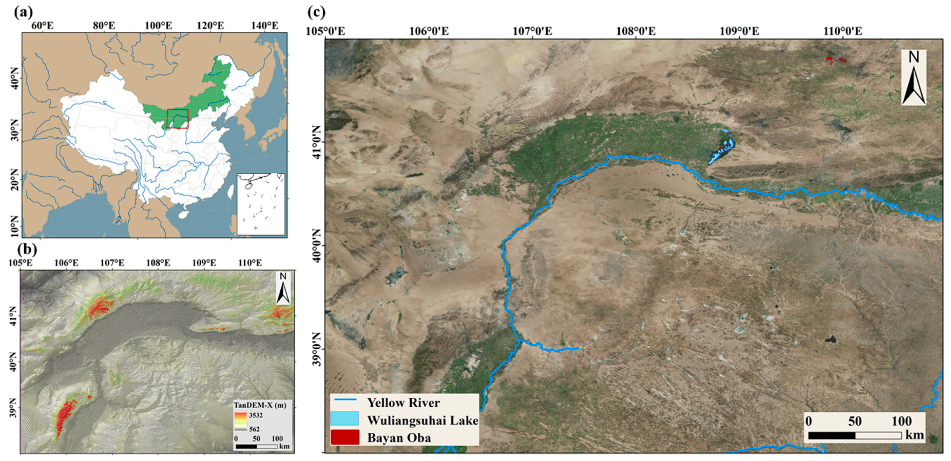
2.1. Study Area
2.2. Data
2.2.1. Multitemporal DEM Data for Delineating Topographic Changes
2.2.2. Landsat Imagery for Delineating Land Surface Spectral Changes
2.3. Methods
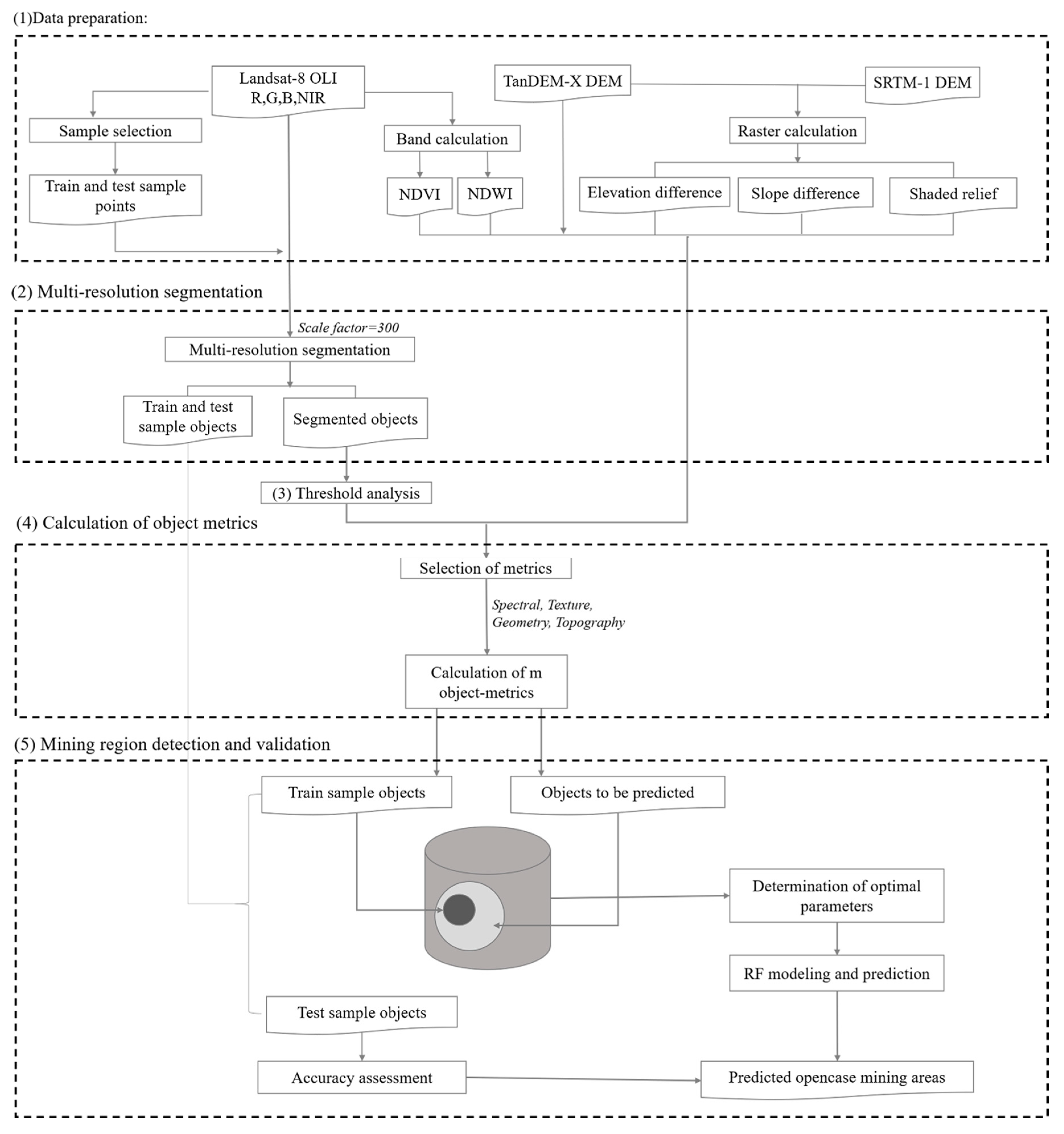
2.3.1. Data Preparation
2.3.2. Spectral Image Segmentation
2.3.3. Threshold Analysis
2.3.4. Calculation of Object Metrics
2.3.5. Mining Region Detection and Validation
3. Results
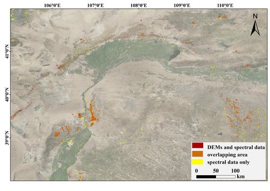
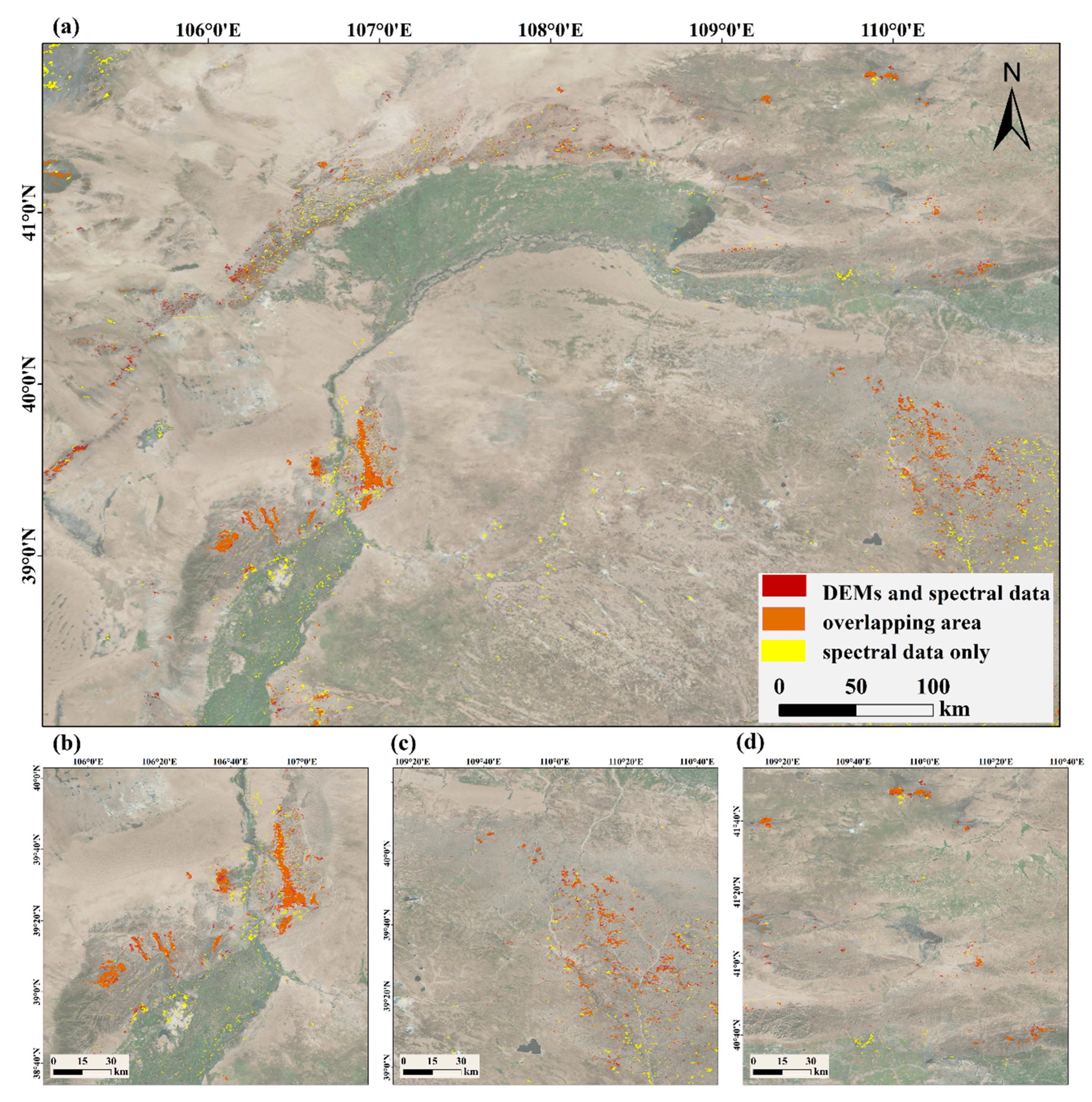
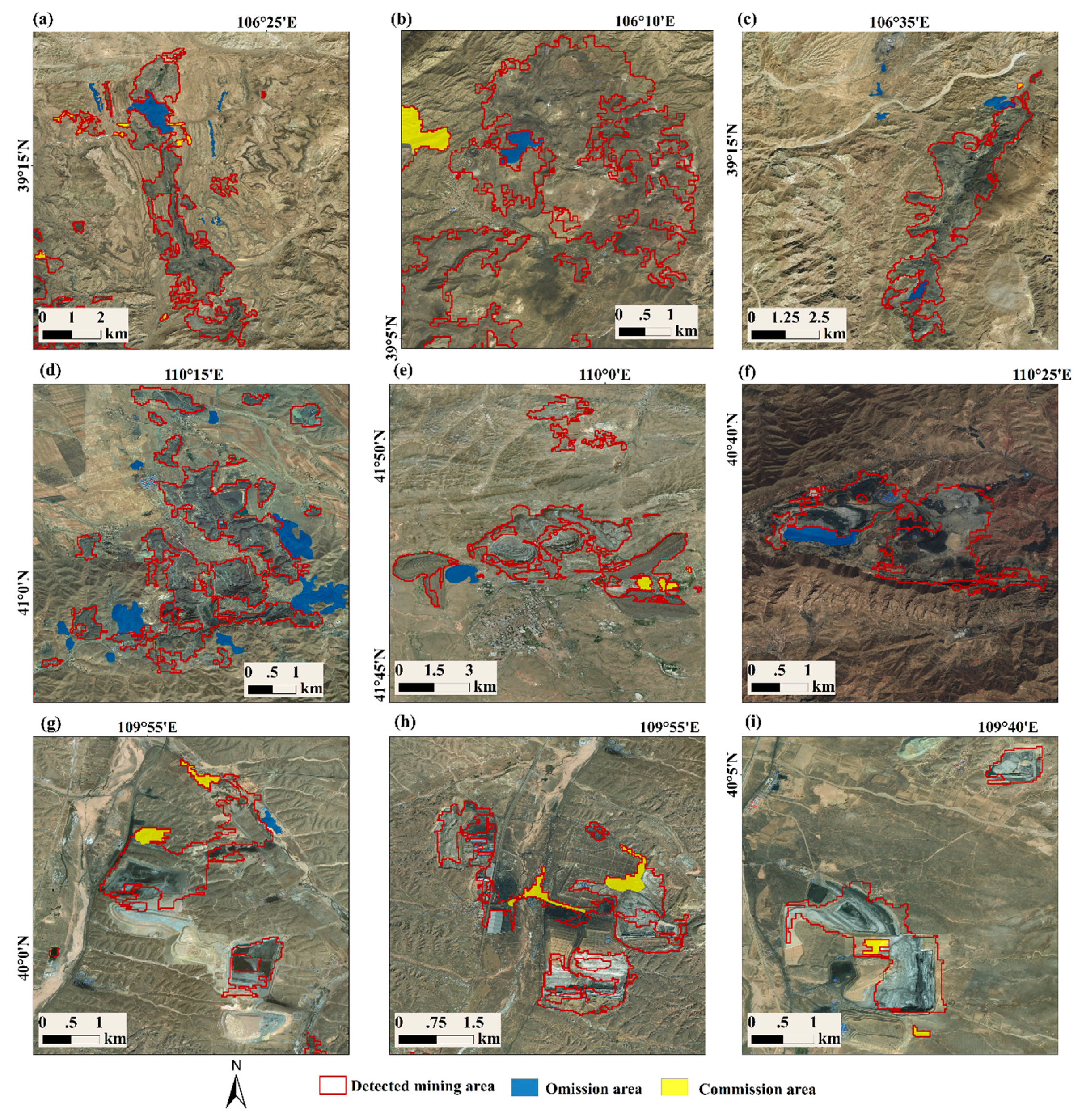
3.1. Assessment of the Detection Result of Opencast Mining Regions
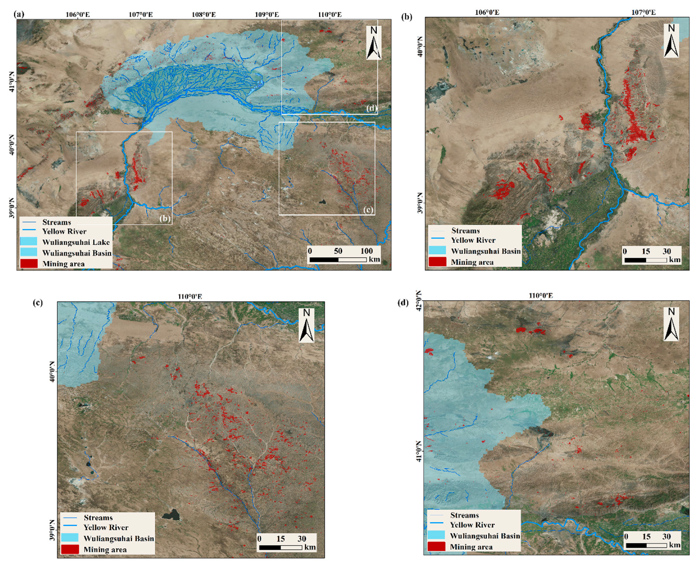
3.2. Spatial Characteristics of Opencast Mining Areas in the Study Area
3.3. Topographic Changes in Opencast Mining Areas
4. Discussion
4.1. Analysis of the Selection of the Classified Sample Points
4.2. Variable Selection according to the Importance Ranking
4.3. Analysis of the Influences of Segmentation Scale Parameter on Detection Accuracy
5. Conclusions
Author Contributions
Funding
Acknowledgments
Conflicts of Interest
References
- Otukei, J.R.; Blaschke, T. Land cover change assessment using decision trees, support vector machines and maximum likelihood classification algorithms. Int. J. Appl. Earth Obs. Geoinf. 2010, 12, S27–S31. [Google Scholar] [CrossRef]
- Petropoulos, G.P.; Partsinevelos, P.; Mitraka, Z. Change detection of surface mining activity and reclamation based on a machine learning approach of multi-temporal Landsat TM imagery. Geocarto Int. 2013, 28, 323–342. [Google Scholar] [CrossRef]
- Styers, D.M.; Chappelka, A.H. Urbanization and atmospheric deposition: Use of bioindicators in determining patterns of land-use change in west Georgia. Water Air Soil Pollut. 2009, 200, 371–386. [Google Scholar] [CrossRef]
- Latifovic, R.; Fytas, K.; Chen, J.; Paraszczak, J. Assessing land cover change resulting from large surface mining development. Int. J. Appl. Earth Obs. Geoinf. 2005, 7, 29–48. [Google Scholar] [CrossRef]
- Moreno-de Las Heras, M.; Merino-Martín, L.; Nicolau, J.M. Effect of vegetation cover on the hydrology of reclaimed mining soils under Mediterranean-Continental climate. Catena 2009, 77, 39–47. [Google Scholar] [CrossRef]
- Gesch, D.B. Analysis of multi-temporal geospatial data sets to assess the landscape effects of surface mining. In Proceedings of the National Meeting of the American Society of Mining and Reclamation, Lexington, KY, USA, 19–23 June 2005; pp. 415–432. [Google Scholar]
- Carlson, T.N.; Ripley, D.A.; Schmugge, T.J. Rapid soil drying and its implications for remote sensing of soil moisture and the surface energy fluxes. In Thermal Remote Sensing in Land Surface Processing; CRC Press: Boca Raton, FL, USA, 2004; pp. 207–226. [Google Scholar]
- De Smedt, F.; Liu, Y.; Gebremeskel, S.; Hoffmann, L.; Pfister, L. Application of GIS and remote sensing in flood modelling for complex terrain. IAHS Publ. 2004, 289, 23–32. [Google Scholar]
- DeFries, R.; Eshleman, K.N. Land-use change and hydrologic processes: A major focus for the future. Hydrol. Process. 2004, 18, 2183–2186. [Google Scholar] [CrossRef]
- Finch, D.M. Habitat use and habitat overlap of riparian birds in three elevational zones: Ecological archives E070-001. Ecology 1989, 70, 866–880. [Google Scholar] [CrossRef]
- Foley, J.A.; Asner, G.P.; Costa, M.H.; Coe, M.T.; DeFries, R.; Gibbs, H.K.; Howard, E.A.; Olson, S.; Patz, J.; Ramankutty, N.; et al. Amazonia revealed: Forest degradation and loss of ecosystem goods and services in the Amazon Basin. Front. Ecol. Environ. 2007, 5, 25–32. [Google Scholar] [CrossRef]
- Foody, G.M.; Mathur, A. Toward intelligent training of supervised image classifications: Directing training data acquisition for SVM classification. Remote Sens. Environ. 2004, 93, 107–117. [Google Scholar] [CrossRef]
- Genxu, W.; Yibo, W.; Ju, Q.; Qingbo, W. Land cover change and its impacts on soil C and N in two watersheds in the center of the Qinghai-Tibetan Plateau. Mt. Res. Dev. 2006, 26, 153–163. [Google Scholar] [CrossRef]
- Griffith, J.A. Geographic techniques and recent applications of remote sensing to landscape-water quality studies. Water Air Soil Pollut. 2002, 138, 181–197. [Google Scholar] [CrossRef]
- Miller, J.D.; Yool, S.R. Mapping forest post-fire canopy consumption in several overstory types using multi-temporal Landsat TM and ETM data. Remote Sens. Environ. 2002, 82, 481–496. [Google Scholar] [CrossRef]
- Shuster, W.D.; Bonta, J.; Thurston, H.; Warnemuende, E.; Smith, D. Impacts of impervious surface on watershed hydrology: A review. Urban Water J. 2005, 2, 263–275. [Google Scholar] [CrossRef]
- Weng, Q. A remote sensing GIS evaluation of urban expansion and its impact on surface temperature in the Zhujiang Delta, China. Int. J. Remote Sens. 2001, 22, 1999–2014. [Google Scholar]
- Abuelgasim, A.; Chung, C.-j.; Champagne, C.; Staenz, K.; Monet, S.; Fung, K. Use of multi-temporal remotely sensed data for monitoring land reclamation in Sudbury, Ontario (Canada). In Proceedings of the 2005 International Workshop on the Analysis of Multi-Temporal Remote Sensing Images, Sydney, Australia, 31 May 2005; Institute of Electrical and Electronics Engineers: Sydney, Australia, 2005; pp. 229–235. [Google Scholar]
- Gillanders, S.N.; Coops, N.C.; Wulder, M.A.; Gergel, S.E.; Nelson, T. Multitemporal remote sensing of landscape dynamics and pattern change: Describing natural and anthropogenic trends. Prog. Phys. Geogr. 2008, 32, 503–528. [Google Scholar] [CrossRef]
- Ieronimidi, E.; Mertikas, S.P.; Hristopoulos, D. Fusion of Quickbird satellite images for vegetation monitoring in previously mined reclaimed areas. In Proceedings of the Remote Sensing for Environmental Monitoring, GIS Applications, and Geology VI, Stockholm, Sweden, 11–14 September 2006; International Society for Optics and Photonics: Bellingham, WA, USA, 2006; p. 636611. [Google Scholar]
- Pagot, E.; Pesaresi, M.; Buda, D.; Ehrlich, D. Development of an object-oriented classification model using very high resolution satellite imagery for monitoring diamond mining activity. Int. J. Remote Sens. 2008, 29, 499–512. [Google Scholar] [CrossRef]
- Demirel, N.; Emil, M.K.; Duzgun, H.S. Surface coal mine area monitoring using multi-temporal high-resolution satellite imagery. Int. J. Coal Geol. 2011, 86, 3–11. [Google Scholar] [CrossRef]
- Li, J.; Zipper, C.E.; Donovan, P.F.; Wynne, R.H.; Oliphant, A.J. Reconstructing disturbance history for an intensively mined region by time-series analysis of Landsat imagery. Environ. Monit. Assess. 2015, 187, 557. [Google Scholar] [CrossRef]
- Sen, S.; Zipper, C.E.; Wynne, R.H.; Donovan, P.F. Identifying revegetated mines as disturbance/recovery trajectories using an interannual Landsat chronosequence. Photogramm. Eng. Remote Sens. 2012, 78, 223–235. [Google Scholar] [CrossRef]
- Townsend, P.A.; Helmers, D.P.; Kingdon, C.C.; McNeil, B.E.; de Beurs, K.M.; Eshleman, K.N. Changes in the extent of surface mining and reclamation in the Central Appalachians detected using a 1976–2006 Landsat time series. Remote Sens. Environ. 2009, 113, 62–72. [Google Scholar] [CrossRef]
- Homer, C.H.; Fry, J.A.; Barnes, C.A. The national land cover database. US Geol. Surv. Fact Sheet. 2012, 3020, 1–4. [Google Scholar]
- Price, S.J.; Dorcas, M.E.; Gallant, A.L.; Klaver, R.W.; Willson, J.D. Three decades of urbanization: Estimating the impact of land-cover change on stream salamander populations. Biol. Conserv. 2006, 133, 436–441. [Google Scholar] [CrossRef]
- Hayakawa, Y.S.; Oguchi, T.; Lin, Z. Comparison of new and existing global digital elevation models: ASTER G-DEM and SRTM-3. Geophys. Res. Lett. 2008, 35, 17404. [Google Scholar] [CrossRef]
- Quinn, M.A.; Kepner, R.; Walgenbach, D.; Foster, R.N.; Bohls, R.; Pooler, P.; Reuter, K.; Swain, J. Effect of habitat characteristics and perturbation from insecticides on the community dynamics of ground beetles (Coleoptera: Carabidae) on mixed-grass rangeland. Environ. Entomol. 1991, 20, 1285–1294. [Google Scholar] [CrossRef]
- Srivastava, S.; Thakur, I.S. Evaluation of biosorption potency of Acinetobacter sp. for removal of hexavalent chromium from tannery effluent. Biodegradation 2007, 18, 637–646. [Google Scholar] [CrossRef]
- Gruber, A.; Wessel, B.; Huber, M.; Roth, A. Operational TanDEM-X DEM calibration and first validation results. ISPRS J. Photogramm. Remote Sens. 2012, 73, 39–49. [Google Scholar] [CrossRef]
- Gdulová, K.; Marešová, J.; Moudrý, V. Accuracy assessment of the global TanDEM-X digital elevation model in a mountain environment. Remote Sens. Environ. 2020, 241, 111724. [Google Scholar] [CrossRef]
- Wessel, B.; Huber, M.; Wohlfart, C.; Marschalk, U.; Kosmann, D.; Roth, A. Accuracy assessment of the global TanDEM-X Digital Elevation Model with GPS data. ISPRS J. Photogramm. Remote Sens. 2018, 139, 171–182. [Google Scholar] [CrossRef]
- Chen, X.; Wang, H. Spatial and temporal variations of vegetation belts and vegetation cover degrees in Inner Mongolia from 1982 to 2003. Acta Geogr. Sin. 2009, 64, 84–94. [Google Scholar]
- Chuai, X.W.; Huang, X.J.; Wang, W.J.; Bao, G. NDVI, temperature and precipitation changes and their relationships with different vegetation types during 1998-2007 in Inner Mongolia, China. Int. J. Climatol. 2013, 33, 1696–1706. [Google Scholar] [CrossRef]
- Farr, T.G.; Kobrick, M. Shuttle Radar Topography Mission produces a wealth of data. Eos Trans. Am. Geophys. Union 2000, 81, 583–585. [Google Scholar] [CrossRef]
- Rizzoli, P.; Martone, M.; Gonzalez, C.; Wecklich, C.; Tridon, D.B.; Bräutigam, B.; Bachmann, M.; Schulze, D.; Fritz, T.; Huber, M.; et al. Generation and performance assessment of the global TanDEM-X digital elevation model. ISPRS J. Photogramm. Remote Sens. 2017, 132, 119–139. [Google Scholar] [CrossRef]
- Gorelick, N.; Hancher, M.; Dixon, M.; Ilyushchenko, S.; Thau, D.; Moore, R. Google Earth Engine: Planetary scale geospatial analysis for everyone. Remote Sens. Environ. 2017, 202, 18–27. [Google Scholar] [CrossRef]
- Tucker, C.J.; Pinzon, J.E.; Brown, M.E.; Slayback, D.A.; Pak, E.W.; Mahoney, R.; Vermote, E.F.; El Saleous, N. An extended AVHRR 8-km NDVI dataset compatible with MODIS and SPOT vegetation NDVI data. Int. J. Remote Sens. 2005, 26, 4485–4498. [Google Scholar] [CrossRef]
- McFeeters, S.K. The use of the Normalized Difference Water Index (NDWI) in the delineation of open water features. Int. J. Remote Sens. 1996, 17, 1425–1432. [Google Scholar] [CrossRef]
- Blaschke, T. Object based image analysis for remote sensing. ISPRS J. Photogramm. Remote Sens. 2010, 65, 2–16. [Google Scholar] [CrossRef]
- Breiman, L. Random forests. Mach. Learn. 2001, 45, 5–32. [Google Scholar] [CrossRef]
- Hussain, M.; Chen, D.; Cheng, A.; Wei, H.; Stanley, D. Change detection from remotely sensed images: From pixel-based to object-based approaches. ISPRS J. Photogramm. Remote Sens. 2013, 80, 91–106. [Google Scholar] [CrossRef]
- Baatz, M.; Schäpe, A. Multiresolution segmentation—An optimization approach for high quality multi-scale image segmentation. In Angewandte Geographische Informations-Verarbeitung XII; Strobl, J., Blaschke, T., Griesebner, G., Eds.; Wichmann Verlag: Karlsruhe, Germany, 2000; pp. 12–23. [Google Scholar]
- Benz, U.C.; Hofmann, P.; Willhauck, G.; Lingenfelder, I.; Heynen, M. Multi-resolution, object-oriented fuzzy analysis of remote sensing data for GIS-ready information. ISPRS J. Photogramm. Remote Sens. 2004, 58, 239–258. [Google Scholar] [CrossRef]
- Ding, H.; Liu, K.; Chen, X.; Xiong, L.; Tang, G.; Qiu, F.; Strobl, J. Optimized Segmentation Based on the Weighted Aggregation Method for Loess Bank Gully Mapping. Remote Sens. 2020, 12, 793. [Google Scholar] [CrossRef]
- Liu, K.; Ding, H.; Tang, G.; Zhu, A.-X.; Yang, X.; Jiang, S.; Cao, J. An object-based approach for two-level gully feature mapping using high-resolution DEM and imagery: A case study on hilly loess plateau region, China. Chin. Geogr. Sci. 2017, 27, 415–430. [Google Scholar] [CrossRef]
- Drǎguţ, L.; Tiede, D.; Levick, S.R. ESP: A tool to estimate scale parameter for multiresolution image segmentation of remotely sensed data. Int. J. Geogr. Inf. Sci. 2010, 24, 859–871. [Google Scholar] [CrossRef]
- Espindola, G.; Câmara, G.; Reis, I.; Bins, L.; Monteiro, A. Parameter selection for region-growing image segmentation algorithms using spatial autocorrelation. Int. J. Remote Sens. 2006, 27, 3035–3040. [Google Scholar] [CrossRef]
- Martha, T.R.; Kerle, N.; Jetten, V.; van Westen, C.J.; Kumar, K.V. Characterising spectral, spatial and morphometric properties of landslides for semi-automatic detection using object-oriented methods. Geomorphology 2010, 116, 24–36. [Google Scholar] [CrossRef]
- Nichol, J.; Wong, M. Satellite remote sensing for detailed landslide inventories using change detection and image fusion. Int. J. Remote Sens. 2005, 26, 1913–1926. [Google Scholar] [CrossRef]
- Stumpf, A.; Kerle, N. Object-oriented mapping of landslides using Random Forests. Remote Sens. Environ. 2011, 115, 2564–2577. [Google Scholar] [CrossRef]
- Trimble. eCognition Developer Reference Book 9.0; Trimble: Munich, Germany, 2014. [Google Scholar]
- Haralick, R.M.; Shanmugam, K.; Dinstein, I.H. Textural features for image classification. IEEE Trans. Syst. Man Cybern. 1973, SMC-3, 610–621. [Google Scholar] [CrossRef]
- Marceau, D.J.; Howarth, P.J.; Dubois, J.-M.M.; Gratton, D.J. Evaluation of the grey-level co-occurrence matrix method for land-cover classification using SPOT imagery. IEEE Trans. Geosci. Remote Sens. 1990, 28, 513–519. [Google Scholar] [CrossRef]
- Belgiu, M.; Drăguţ, L. Random forest in remote sensing: A review of applications and future directions. ISPRS J. Photogramm. Remote Sens. 2016, 114, 24–31. [Google Scholar] [CrossRef]
- Guan, H.; Li, J.; Chapman, M.; Deng, F.; Ji, Z.; Yang, X. Integration of orthoimagery and lidar data for object-based urban thematic mapping using random forests. Int. J. Remote Sens. 2013, 34, 5166–5186. [Google Scholar] [CrossRef]
- Gislason, P.O.; Benediktsson, J.A.; Sveinsson, J.R. Random forests for land cover classification. Pattern Recognit. Lett. 2006, 27, 294–300. [Google Scholar] [CrossRef]
- Liaw, A.; Wiener, M. Classification and regression by randomForest. R News 2002, 2, 18–22. [Google Scholar]
- Schmidt, A.; Niemeyer, J.; Rottensteiner, F.; Soergel, U. Contextual classification of full waveform lidar data in the Wadden Sea. IEEE Geosci. Remote Sens. Lett. 2014, 11, 1614–1618. [Google Scholar] [CrossRef]
- Svetnik, V.; Liaw, A.; Tong, C.; Wang, T. Application of Breiman’s random forest to modeling structure-activity relationships of pharmaceutical molecules. In Proceedings of the Multiple Classifier Systems, International Workshop, MCS 2004, Cagliari, Italy, 9–11 June 2004; pp. 334–343. [Google Scholar]
- Bekkar, M.; Djemaa, H.K.; Alitouche, T.A. Evaluation measures for models assessment over imbalanced data sets. J. Inf. Eng. Appl. 2013, 3, 27–38. [Google Scholar]
- Drăguţ, L.; Csillik, O.; Eisank, C.; Tiede, D. Automated parameterisation for multi-scale image segmentation on multiple layers. ISPRS J. Photogramm. Remote Sens. 2014, 88, 119–127. [Google Scholar] [CrossRef]
- Puissant, A.; Rougier, S.; Stumpf, A. Object-oriented mapping of urban trees using Random Forest classifiers. Int. J. Appl. Earth Obs. Geoinf. 2014, 26, 235–245. [Google Scholar] [CrossRef]
- Duro, D.C.; Franklin, S.E.; Dubé, M.G. Multi-scale object-based image analysis and feature selection of multi-sensor earth observation imagery using random forests. Int. J. Remote Sens. 2012, 33, 4502–4526. [Google Scholar] [CrossRef]


| Feature Type | Feature Name | Acronym | Number |
|---|---|---|---|
| Spectral Information | Mean brightness | Brightness | 1 |
| Maximum difference index | Max_diff | 1 | |
| Mean band value | Red; Green; Blue; NIR; NDVI; NDWI; | 6 | |
| Texture information | GLCM homogeneity | All.dir; 0°;45°;90°;135° | 5 |
| GLCM dissimilarity | All.dir; 0°;45°;90°;135° | 5 | |
| GLCM entropy | All.dir; 0°;45°;90°;135° | 5 | |
| GLCM correlation | All.dir; 0°;45°;90°;135° | 5 | |
| GLCM contrast | All.dir; 0°;45°;90°;135° | 5 | |
| GLCM angular second moment | All.dir; 0°;45°;90°;135° | 5 | |
| GLCM mean | All.dir; 0°;45°;90°;135° | 5 | |
| GLCM standard deviation | All.dir; 0°;45°;90°;135° | 5 | |
| Geometric information | Shape index | Shape index | 1 |
| Length-width | Length-width | 1 | |
| Roundness | Roundness | 1 | |
| Asymmetry | Asymmetry | 1 | |
| Compactness | Compactness | 1 | |
| Area | Area | 1 | |
| Length | Length | 1 | |
| Rectangular fit | Rectangular fit | 1 | |
| Topographic information | Mean DEM | TanDEM-X | 1 |
| Mean elevation difference | Elevation difference | 1 | |
| Mean slope difference | Slope difference | 1 | |
| Mean terrain relief | Terrain relief | 1 |
| Feature Type | Feature Name | MDA |
|---|---|---|
| Spectral Information | Max_diff | 54.0082 |
| Topographic information | Terrain relief | 45.5290 |
| Topographic information | TanDEM-X | 38.3774 |
| Spectral Information | Blue | 31.7928 |
| Spectral Information | NIR | 29.8755 |
| Spectral Information | NDVI | 26.9931 |
| Spectral Information | NDWI | 26.6775 |
| Topographic information | Elevation difference | 26.2670 |
| Topographic information | Slope difference | 24.1456 |
| Spectral Information | Brightness | 22.8597 |
| Texture information | GCLM.StdDev.90° | 22.0214 |
| Texture information | GCLM.StdDev.all.dir | 19.2742 |
| Texture information | GCLM.StdDev.45° | 18.6994 |
| Spectral and DEMs Data | Predicted Class | Spectral Data | Predicted Class | ||||
|---|---|---|---|---|---|---|---|
| Non-Mining Area | Mining Area | Non-Mining Area | Mining Area | ||||
| ACTUAL CLASS | Non-mining area | 31(TN) | 1(FP) | Actual Class | Non-mining area | 30(TN) | 2(FP) |
| Mining area | 2(FN) | 18(TP) | Mining area | 3(FN) | 17(TP) | ||
| PRECISION (%) | 94.74 | Precision (%) | 89.47 | ||||
| RECALL (%) | 90.00 | Recall (%) | 85.00 | ||||
| OVERALL ACCURACY (%) | 94.23 | Overall Accuracy (%) | 90.38 | ||||
| KAPPA (%) | 87.38 | Kappa (%) | 78.96 | ||||
| F-MEASURE (%) | 92.31 | F-measure (%) | 87.18 | ||||
| Sample | Number of Mining Area Points | Number of Non-Mining Area Points | Total Points | OOB Error (%) |
|---|---|---|---|---|
| Sample I | 26 | 46 | 72 | 11.11 |
| Sample II | 71 | 142 | 213 | 9.91 |
| Sample III | 71 | 182 | 253 | 9.52 |
| Sample IV | 85 | 154 | 239 | 10.5 |
© 2020 by the authors. Licensee MDPI, Basel, Switzerland. This article is an open access article distributed under the terms and conditions of the Creative Commons Attribution (CC BY) license (http://creativecommons.org/licenses/by/4.0/).
Share and Cite
Wu, Q.; Song, C.; Liu, K.; Ke, L. Integration of TanDEM-X and SRTM DEMs and Spectral Imagery to Improve the Large-Scale Detection of Opencast Mining Areas. Remote Sens. 2020, 12, 1451. https://doi.org/10.3390/rs12091451
Wu Q, Song C, Liu K, Ke L. Integration of TanDEM-X and SRTM DEMs and Spectral Imagery to Improve the Large-Scale Detection of Opencast Mining Areas. Remote Sensing. 2020; 12(9):1451. https://doi.org/10.3390/rs12091451
Chicago/Turabian StyleWu, Qianhan, Chunqiao Song, Kai Liu, and Linghong Ke. 2020. "Integration of TanDEM-X and SRTM DEMs and Spectral Imagery to Improve the Large-Scale Detection of Opencast Mining Areas" Remote Sensing 12, no. 9: 1451. https://doi.org/10.3390/rs12091451
APA StyleWu, Q., Song, C., Liu, K., & Ke, L. (2020). Integration of TanDEM-X and SRTM DEMs and Spectral Imagery to Improve the Large-Scale Detection of Opencast Mining Areas. Remote Sensing, 12(9), 1451. https://doi.org/10.3390/rs12091451