The 2018 Long Rainy Season in Kenya: Hydrological Changes and Correlated Land Subsidence


Abstract
:1. Introduction
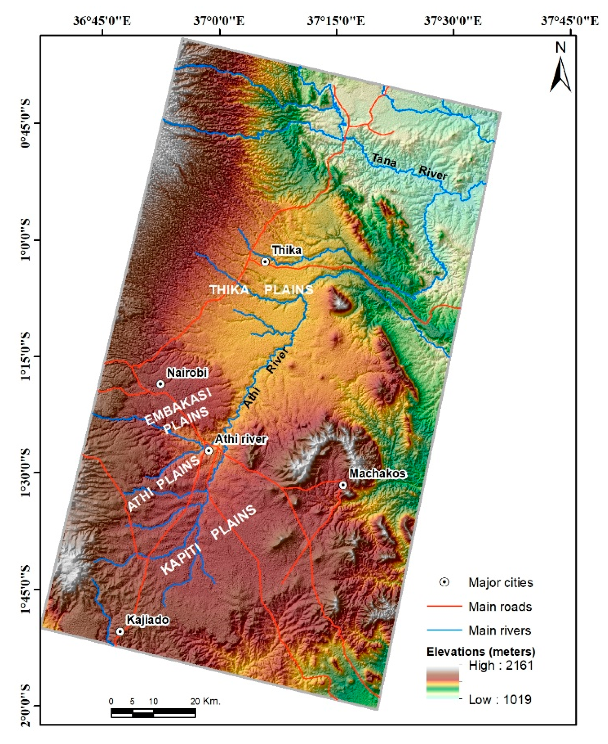
2. Materials and Methods
2.1. Hydrological Data (CPC, SMAP, VIC, NOAH-3.3)
2.2. Geodetic Data
2.3. Loading Model (HYDL)
3. Results
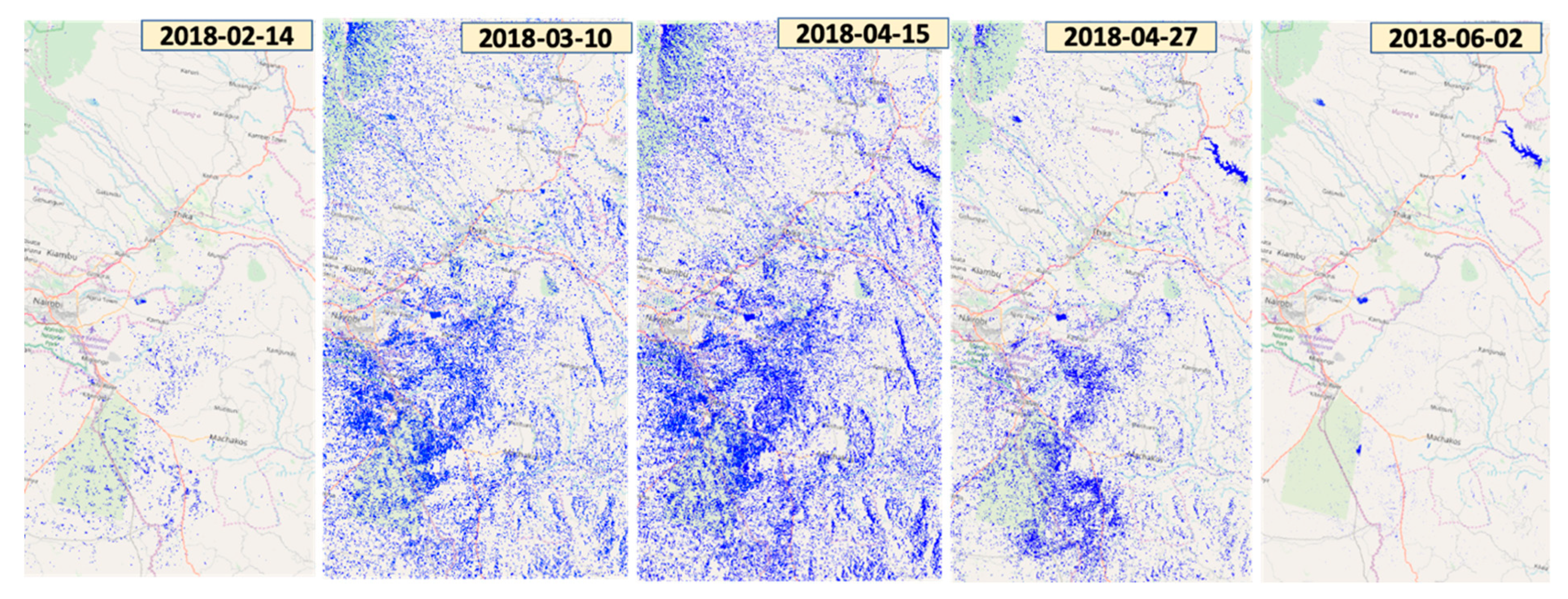
3.1. Hydrological Responses to the Long Rainy Season MAM 2018
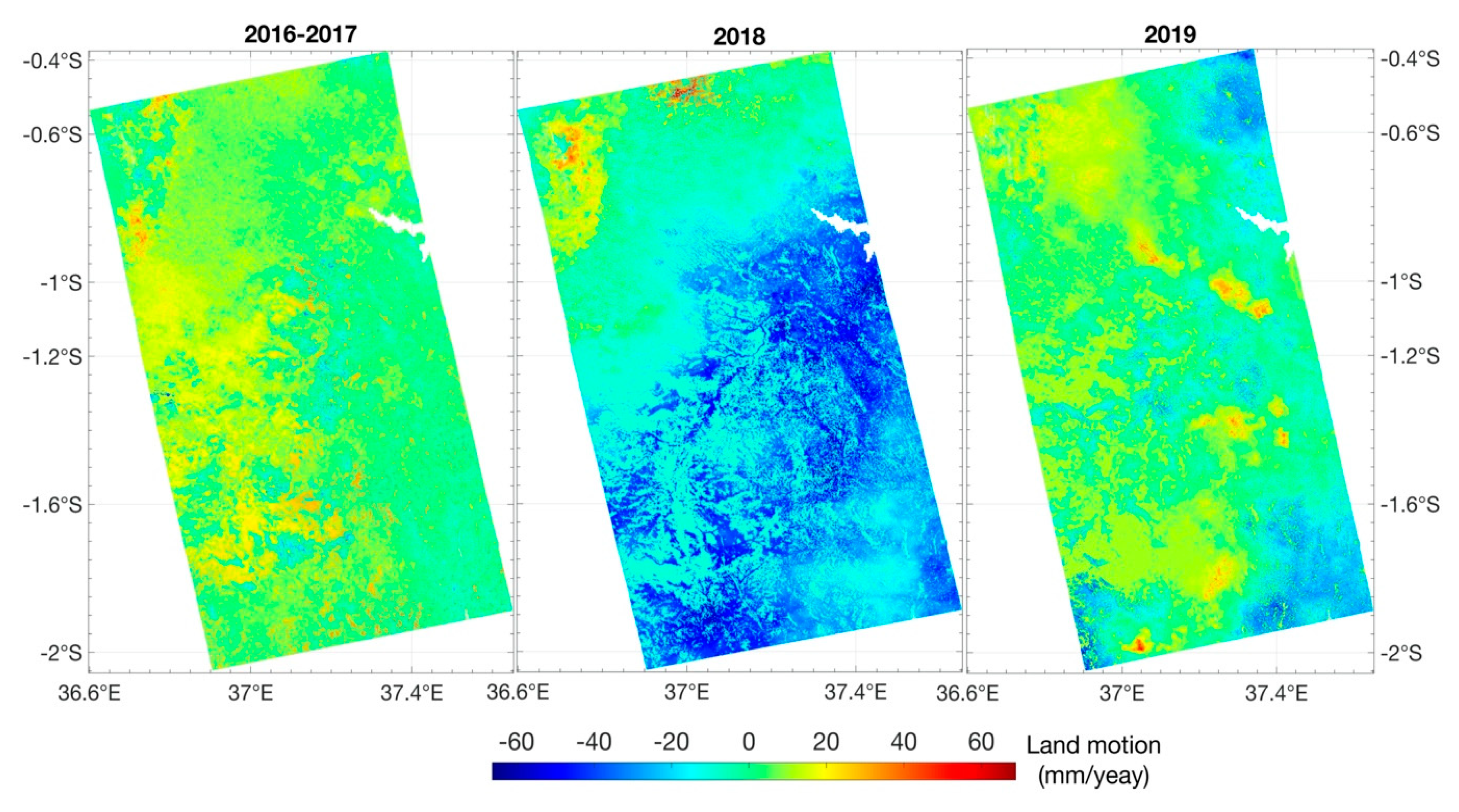
3.2. Land Deformation Related to MAM Season
4. Discussion
5. Conclusions
Supplementary Materials
Author Contributions
Funding
Acknowledgments
Conflicts of Interest
Data Availability
References
- Kilavi, M.; MacLeod, D.; Ambani, M.; Robbins, J.; Dankers, R.; Graham, R.; Helen, T.; Salih, A.; Todd, M. Extreme rainfall and flooding over central Kenya including Nairobi city during the long-rains season 2018: Causes, predictability, and potential for early warning and actions. Atmosphere 2018, 9, 472. [Google Scholar] [CrossRef] [Green Version]
- OCHA. OCHA Flash Update #1: Floods in Kenya|25 April 2018; OCHA: New York, NY, USA, 2018. [Google Scholar]
- OCHA. OCHA Somalia Flash Update #4-Humanitarian Impact of Heavy Rains|8 May 2018; OCHA: New York, NY, USA, 2018. [Google Scholar]
- Ogwang, B.A.; Kabengwela, M.H.; Dione, C.; Kamga, A. The State of Climate of Africa in 2017; African Centre for Meteorological Applications for Development: Niamey, Niger, 2018. [Google Scholar]
- Dindi, E. An assessment of the performance of the geophysical methods as a tool for the detection of zones of potential subsidence in the area southwest of Nakuru town, Kenya. Environ. Earth Sci. 2015, 73, 3643–3653. [Google Scholar] [CrossRef]
- Nicholson, S.E. An analysis of recent rainfall conditions in eastern Africa. Int. J. Climatol. 2016, 36, 526–532. [Google Scholar] [CrossRef]
- Nicholson, S.E. Climate and climatic variability of rainfall over eastern Africa. Rev. Geophys. 2017, 55, 590–635. [Google Scholar] [CrossRef] [Green Version]
- AEA Group. Final Report. Kenya: Climate Screening and Information Exchange; AEA Group: Birmingham, AL, USA, 2008. [Google Scholar]
- MacLeod, D. Seasonal forecasts of the East African long rains: Insight from atmospheric relaxation experiments. Clim. Dyn. 2019, 53, 4505–4520. [Google Scholar] [CrossRef] [Green Version]
- Parry, J.-E.; Echeverria, D.; Dekens, J.; Maitima, J. Climate risks, vulnerability and governance in Kenya: A review. In Commissioned by: Climate Risk Management Technical Assistance Support Project (CRM TASP), Joint Initiative of Bureau for Crisis Prevention and Recovery and Bureau for Development Policy of UNDP. 2012. Available online: https://www.iisd.org/pdf/2013/climate_risks_kenya.pdf (accessed on 28 April 2020).
- Abuuru, D. Ground Subsidence in the Nakuru area: Results of the Seismic Refraction Survey; Mines and Geological Department: Nairobi, Kenya, 1990.
- Ngecu, W.M.; Nyambok, I.O. Ground subsidence and its socio-economic implications on the population: A case study of the Nakuru area in Central Rift Valley, Kenya. Environ. Geol. 2000, 39, 567–574. [Google Scholar] [CrossRef]
- Fu, Y.N.; Freymueller, J.T.; Jensen, T. Seasonal hydrological loading in southern Alaska observed by GPS and GRACE. Geophys. Res. Lett. 2012, 39. [Google Scholar] [CrossRef] [Green Version]
- Fu, Y.; Freymueller, J.T. Seasonal and long-term vertical deformation in the Nepal Himalaya constrained by GPS and GRACE measurements. J. Geophys. Res. Solid Earth 2012, 117. [Google Scholar] [CrossRef]
- Nahmani, S.; Bock, O.; Bouin, M.N.; Santamaria-Gomez, A.; Boy, J.P.; Collilieux, X.; Metivier, L.; Panet, I.; Genthon, P.; de Linage, C.; et al. Hydrological deformation induced by the West African Monsoon: Comparison of GPS, GRACE and loading models. J. Geophys. Res. Solid Earth 2012, 117. [Google Scholar] [CrossRef] [Green Version]
- Birhanu, Y.; Bendick, R. Monsoonal loading in Ethiopia and Eritrea from vertical GPS displacement time series. J. Geophys. Res. Solid Earth 2015, 120, 7231–7238. [Google Scholar] [CrossRef] [Green Version]
- Han, S.C. Elastic deformation of the Australian continent induced by seasonal water cycles and the 2010-2011 La Nina determined using GPS and GRACE. Geophys. Res. Lett. 2017, 44, 2763–2772. [Google Scholar] [CrossRef]
- Steckler, M.S.; Nooner, S.L.; Akhter, S.H.; Chowdhury, S.K.; Bettadpur, S.; Seeber, L.; Kogan, M.G. Modeling Earth deformation from monsoonal flooding in Bangladesh using hydrographic, GPS, and Gravity Recovery and Climate Experiment (GRACE) data. J. Geophys. Res. Solid Earth 2010, 115. [Google Scholar] [CrossRef]
- Twele, A.; Cao, W.X.; Plank, S.; Martinis, S. Sentinel-1-based flood mapping: A fully automated processing chain. Int. J. Remote Sens. 2016, 37, 2990–3004. [Google Scholar] [CrossRef]
- Martinis, S. Improving flood mapping in arid areas using Sentinel-1 time series data. In Proceedings of the 2017 IEEE International Geoscience and Remote Sensing Symposium (IGARSS), Fort Worth, TX, USA, 23–28 July 2017; pp. 193–196. [Google Scholar]
- Prasetyo, Y.; Yuwono, B.; Ramadhanis, Z. Spatial Analysis of Land Subsidence and Flood Pattern Based on DInSAR Method in Sentinel Sar Imagery and Weighting Method in Geo-Hazard Parameters Combination in North Jakarta Region. In Proceedings of the IOP Conference Series: Earth and Environmental Science, Surakarta, Central Java, Indonesia, 9–10 August 2017; p. 012009. [Google Scholar]
- Miller, M.M.; Shirzaei, M. Land subsidence in Houston correlated with flooding from Hurricane Harvey. Remote. Sens. Environ. 2019, 225, 368–378. [Google Scholar] [CrossRef]
- Zhang, B.; Wdowinski, S.; Oliver-Cabrera, T.; Koirala, R.; Jo, M.; Osmanoglu, B. Mapping the extent and magnitude of sever flooding induced by Hurricane IRMA with multi-temporal SENTINEL-1 SAR and Insar observations. Int. Arch. Photogramm. Remote Sens. Spat. Inf. Sci. 2018, 42, 2237–2244. [Google Scholar] [CrossRef] [Green Version]
- Chini, M.; Pelich, R.; Pulvirenti, L.; Pierdicca, N.; Hostache, R.; Matgen, P. Sentinel-1 InSAR Coherence to Detect Floodwater in Urban Areas: Houston and Hurricane Harvey as A Test Case. Remote Sens. Basel 2019, 11, 107. [Google Scholar] [CrossRef] [Green Version]
- Chen, M.; Shi, W.; Xie, P.; Silva, V.B.; Kousky, V.E.; Wayne Higgins, R.; Janowiak, J.E. Assessing objective techniques for gauge-based analyses of global daily precipitation. J. Geophys. Res. Atmos. 2008, 113, D04110. [Google Scholar] [CrossRef]
- Entekhabi, D.; Njoku, E.G.; O’Neill, P.E.; Kellogg, K.H.; Crow, W.T.; Edelstein, W.N.; Entin, J.K.; Goodman, S.D.; Jackson, T.J.; Johnson, J. The soil moisture active passive (SMAP) mission. Proc. IEEE 2010, 98, 704–716. [Google Scholar] [CrossRef]
- Jackson, T.; O’Neill, P.; Njoku, E.; Chan, S.; Bindlish, R.; Colliander, A.; Entekhabi, D. Soil Moisture Active Passive (SMAP) Project Calibration and Validation for the L2/3_SM_P Version 3 Data Products; JPL D-93720; Jet Propulsion Laboratory, California Institute of Technology, JPL Publication: Pasadena, CA, USA, 2016. [Google Scholar]
- Rodell, M.; Houser, P.R.; Jambor, U.; Gottschalck, J.; Mitchell, K.; Meng, C.J.; Arsenault, K.; Cosgrove, B.; Radakovich, J.; Bosilovich, M.; et al. The global land data assimilation system. Bull. Am. Meteorol. Soc. 2004, 85, 381. [Google Scholar] [CrossRef] [Green Version]
- Beaudoing, M.R.H.K. GLDAS VIC Land Surface Model L4 Monthly 1.0 × 1.0 Degree V001; Goddard Earth Sciences Data and Information Services Center (GES DISC), Ed.; Goddard Earth Sciences Data and Information Services Center (GES DISC): Greenbelt, MD, USA, 2007. [CrossRef]
- Beaudoing, H.M.R. GLDAS Noah Land Surface Model L4 Monthly 0.25 × 0.25 Degree V2.1; Goddard Earth Sciences Data and Information Services Center (GES DISC): Greenbelt, MD, USA, 2016. [CrossRef]
- Rui, H.; Beaudoing, H. README Document for NASA GLDAS Version 2 Data Products; National Aeronautics and Space Administration Goddard Earth Science Data Information and Services Center (GES DISC): Greenbelt, MD, USA, 2018.
- Choulakian, V.; Eljabi, N.; Moussi, J. On the Distribution of Flood Volume in Partial Duration Series Analysis of Flood Phenomena. Stoch. Hydrol. Hydraul. 1990, 4, 217–226. [Google Scholar] [CrossRef]
- Blewitt, G.; Hammond, W.; Kreemer, C. Harnessing the GPS data explosion for interdisciplinary science. Eos 2018, 99, 1–2. [Google Scholar] [CrossRef]
- Zumberge, J.F.; Heflin, M.B.; Jefferson, D.C.; Watkins, M.M.; Webb, F.H. Precise point positioning for the efficient and robust analysis of GPS data from large networks. J. Geophys. Res. Solid Earth 1997, 102, 5005–5017. [Google Scholar] [CrossRef] [Green Version]
- Hammond, W.C.; Blewitt, G.; Kreemer, C. GPS Imaging of vertical land motion in California and Nevada: Implications for Sierra Nevada uplift. J. Geophys. Res. Solid Earth 2016, 121, 7681–7703. [Google Scholar] [CrossRef] [PubMed]
- Blewitt, G.; Kreemer, C.; Hammond, W.C.; Gazeaux, J. MIDAS robust trend estimator for accurate GPS station velocities without step detection. J. Geophys. Res. Solid Earth 2016, 121, 2054–2068. [Google Scholar] [CrossRef] [PubMed]
- Wdowinski, S.; Bock, Y.; Zhang, J.; Fang, P.; Genrich, J. Southern California Permanent GPS Geodetic Array: Spatial filtering of daily positions for estimating coseismic and postseismic displacements induced by the 1992 Landers earthquake. J. Geophys. Res. Solid Earth 1997, 102, 18057–18070. [Google Scholar] [CrossRef]
- Golyandina, N.; Nekrutkin, V.; Zhigljavsky, A.A. Analysis of Time Series Structure: SSA and Related Techniques; Chapman and Hall/CRC: Boca Raton, FL, USA; New York, NY, USA; Washington, DC, USA; London, UK, 2001. [Google Scholar]
- Chen, Q.; van Dam, T.; Sneeuw, N.; Collilieux, X.; Weigelt, M.; Rebischung, P. Singular spectrum analysis for modeling seasonal signals from GPS time series. J. Geodyn. 2013, 72, 25–35. [Google Scholar] [CrossRef]
- Farr, T.G.; Rosen, P.A.; Caro, E.; Crippen, R.; Duren, R.; Hensley, S.; Kobrick, M.; Paller, M.; Rodriguez, E.; Roth, L.; et al. The shuttle radar topography mission. Rev. Geophys. 2007, 45. [Google Scholar] [CrossRef] [Green Version]
- Sandwell, D.; Mellors, R.; Tong, X.; Wei, M.; Wessel, P. GMTSAR: An InSAR Processing System Based on Generic Mapping Tools; Library—Scripps Digital Collection: San Diego, UC, USA, 2011. [Google Scholar]
- Chen, C.W.; Zebker, H.A. Phase unwrapping for large SAR interferograms: Statistical segmentation and generalized network models. IEEE Trans. Geosci. Remote 2002, 40, 1709–1719. [Google Scholar] [CrossRef] [Green Version]
- Berardino, P.; Fornaro, G.; Lanari, R.; Sansosti, E. A new algorithm for surface deformation monitoring based on small baseline differential SAR interferograms. IEEE Trans. Geosci. Remote 2002, 40, 2375–2383. [Google Scholar] [CrossRef] [Green Version]
- Tong, X.P.; Schmidt, D. Active movement of the Cascade landslide complex in Washington from a coherence-based InSAR time series method. Remote Sens. Environ. 2016, 186, 405–415. [Google Scholar] [CrossRef]
- Tymofyeyeva, E.; Fialko, Y. Mitigation of atmospheric phase delays in InSAR data, with application to the eastern California shear zone. J. Geophys. Res. Solid Earth 2015, 120, 5952–5963. [Google Scholar] [CrossRef]
- Freeman, A. Radiometric calibration of SAR image data. Int. Arch. Photogramm. Remote Sens. 1993, 29, 212. [Google Scholar]
- Lee, J.-S.; Jurkevich, L.; Dewaele, P.; Wambacq, P.; Oosterlinck, A. Speckle filtering of synthetic aperture radar images: A review. Remote Sens. Rev. 1994, 8, 313–340. [Google Scholar] [CrossRef]
- Wegmuller, U. Automated terrain corrected SAR geocoding. In Proceedings of the IEEE 1999 International Geoscience and Remote Sensing Symposium, IGARSS’99 (Cat. No. 99CH36293), Hamburg, Germany, 28 June–2 July 1999; pp. 1712–1714. [Google Scholar]
- Dill, R.; Dobslaw, H. Numerical simulations of global-scale high-resolution hydrological crustal deformations. J. Geophys. Res. Solid Earth 2013, 118, 5008–5017. [Google Scholar] [CrossRef]
- OCHA. East Africa Drought Situation Report No. 1|February 21, 2017; OCHA: New York, NY, USA, 2017. [Google Scholar]
- Uhe, P.; Philip, S.; Kew, S.; Shah, K.; Kimutai, J.; Mwangi, E.; van Oldenborgh, G.J.; Singh, R.; Arrighi, J.; Jjemba, E.; et al. Attributing drivers of the 2016 Kenyan drought. Int. J. Climatol. 2018, 38, e554–e568. [Google Scholar] [CrossRef] [Green Version]
- Zheng, H.; Yang, Z.L.; Lin, P.R.; Wei, J.F.; Wu, W.Y.; Li, L.C.; Zhao, L.; Wang, S. On the Sensitivity of the Precipitation Partitioning Into Evapotranspiration and Runoff in Land Surface Parameterizations. Water Resour. Res. 2019, 55, 95–111. [Google Scholar] [CrossRef]
- Schira, M.J.M.O.Z. Smapr: Acquisition and Processing of NASA Soil Moisture Active-Passive. 2019. Available online: https://cran.r-project.org/web/packages/smapr/index.html (accessed on 28 April 2020).
- Chen, Y.-G.; Liu, T.-K. Holocene uplift and subsidence along an active tectonic margin southwestern Taiwan. Quat. Sci. Rev. 2000, 19, 923–930. [Google Scholar] [CrossRef]
- Liang, B.; Zhang, G.-S.; Liu, D.-R. Experimental study on thawing subsidence characters of permafrost under frost heaving and thawingcirculation. Yantu Gongcheng Xuebao Chin. J. Geotech. Eng. 2006, 28, 1213–1217. [Google Scholar]
- Coplin, L.; Galloway, D. Houston-Galveston, Texas: Land Subsidence in the United States. US Geol. Surv. Circ. 1999, 1182, 35–48. [Google Scholar]
- Sneed, M.; Galloway, D.L. Aquifer-System Compaction and Land Subsidence: Measurements, Analyses, and Simulations: The Holly Site, Edwards Air Force Base, Antelope Valley, California; US Department of the Interior, US Geological Survey: Washington, DC, USA, 2000.
- Rateb, A.; Kuo, C.Y. Quantifying Vertical Deformation in the Tigris-Euphrates Basin Due to the Groundwater Abstraction: Insights from GRACE and Sentinel-1 Satellites. Water 2019, 11, 1658. [Google Scholar] [CrossRef] [Green Version]
- Chaussard, E.; Wdowinski, S.; Cabral-Cano, E.; Amelung, F. Land subsidence in central Mexico detected by ALOS InSAR time-series. Remote Sens. Environ. 2014, 140, 94–106. [Google Scholar] [CrossRef]
- Holzer, T.L.; Bluntzer, R.L. Land Subsidence Near Oil and Gas Fields, Houston, Texas. Groundwater 1984, 22, 450–459. [Google Scholar] [CrossRef]
- Psimoulis, P.; Ghilardi, M.; Fouache, E.; Stiros, S. Subsidence and evolution of the Thessaloniki plain, Greece, based on historical leveling and GPS data. Eng. Geol. 2007, 90, 55–70. [Google Scholar] [CrossRef]
- Holzer, T.L. Mitigating Losses from Land Subsidence in the United States; National Academies: Washington, DC, USA, 1991. [Google Scholar] [CrossRef]
- Waltham, T.; Waltham, A.C.; Bell, F.G.; Culshaw, M.G. Sinkholes and Subsidence: Karst and Cavernous Rocks in Engineering and Construction; Springer Science & Business Media: Berlin/Heidelberg, Germany, 2005. [Google Scholar]
- Ojany, F.F. The Mound Topography of the Thika and Athi Plains of Kenya: A Problem of Origin (Die Kleinhügeltopographie der Thikaund Athi-Ebenen von Kenya: Das Problem ihres Ursprungs). Erdkunde 1968, 269–275. [Google Scholar]
- Gevaerts, E. Hydrogeology of the Nairobi area; Government of Kenya, Water Development Department: Nairobi, Kenya, 1964.
- Gregory, J.W. The Rift Valleys and Geology of East Africa: An Account of the Origin & History of the Rift Valleys of East Africa & Their Relation to the Contemporary Earth-Movements Which Transformed the Geography of the World. With Some account of the Prehistoric Stone Implements, Soils, Water Supply, & Mineral Resources of the Kenya Colony; Seeley, Service & Co. limited: London, UK, 1921. [Google Scholar]
- Scott, R.M. The Soils of the Nairobi-Thika-Yatta-Machakos Area; Government of Kenya, Department of Agriculture: Nairobi, Kenya, 1963.
- Saggerson, E. Geology of the Nairobi Area; Mines & Geological Department: Nairobi, Kenya, 1991.
- Huang, L.-S.; McRaney, J.; Teng, T.-L.; Prebish, M. A preliminary study on the relationship between precipitation and large earthquakes in Southern California. Pure Appl. Geophys. 1979, 117, 1286–1300. [Google Scholar] [CrossRef]
- Wang, J.; Gao, W.; Xu, S.; Yu, L. Evaluation of the combined risk of sea level rise, land subsidence, and storm surges on the coastal areas of Shanghai, China. Clim. Chang. 2012, 115, 537–558. [Google Scholar] [CrossRef]
- Dixon, T.H.; Amelung, F.; Ferretti, A.; Novali, F.; Rocca, F.; Dokka, R.; Sella, G.; Kim, S.-W.; Wdowinski, S.; Whitman, D. Subsidence and flooding in New Orleans. Nature 2006, 441, 587–588. [Google Scholar] [CrossRef]

© 2020 by the authors. Licensee MDPI, Basel, Switzerland. This article is an open access article distributed under the terms and conditions of the Creative Commons Attribution (CC BY) license (http://creativecommons.org/licenses/by/4.0/).
Share and Cite
Rateb, A.; Hermas, E. The 2018 Long Rainy Season in Kenya: Hydrological Changes and Correlated Land Subsidence. Remote Sens. 2020, 12, 1390. https://doi.org/10.3390/rs12091390
Rateb A, Hermas E. The 2018 Long Rainy Season in Kenya: Hydrological Changes and Correlated Land Subsidence. Remote Sensing. 2020; 12(9):1390. https://doi.org/10.3390/rs12091390
Chicago/Turabian StyleRateb, Ashraf, and ElSayed Hermas. 2020. "The 2018 Long Rainy Season in Kenya: Hydrological Changes and Correlated Land Subsidence" Remote Sensing 12, no. 9: 1390. https://doi.org/10.3390/rs12091390
APA StyleRateb, A., & Hermas, E. (2020). The 2018 Long Rainy Season in Kenya: Hydrological Changes and Correlated Land Subsidence. Remote Sensing, 12(9), 1390. https://doi.org/10.3390/rs12091390