Surface Rupture Kinematics and Coseismic Slip Distribution during the 2019 Mw7.1 Ridgecrest, California Earthquake Sequence Revealed by SAR and Optical Images
Abstract
1. Introduction
2. Data and Methods
2.1. Horizontal Displacement Fields by Subpixel Correlation of Optical Images
2.2. Coseismic Deformation from InSAR
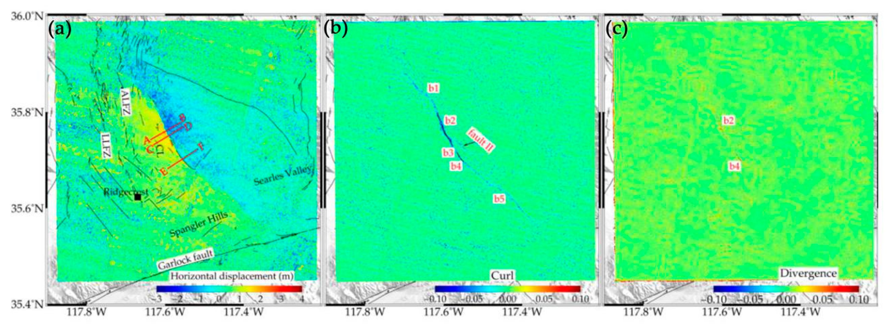
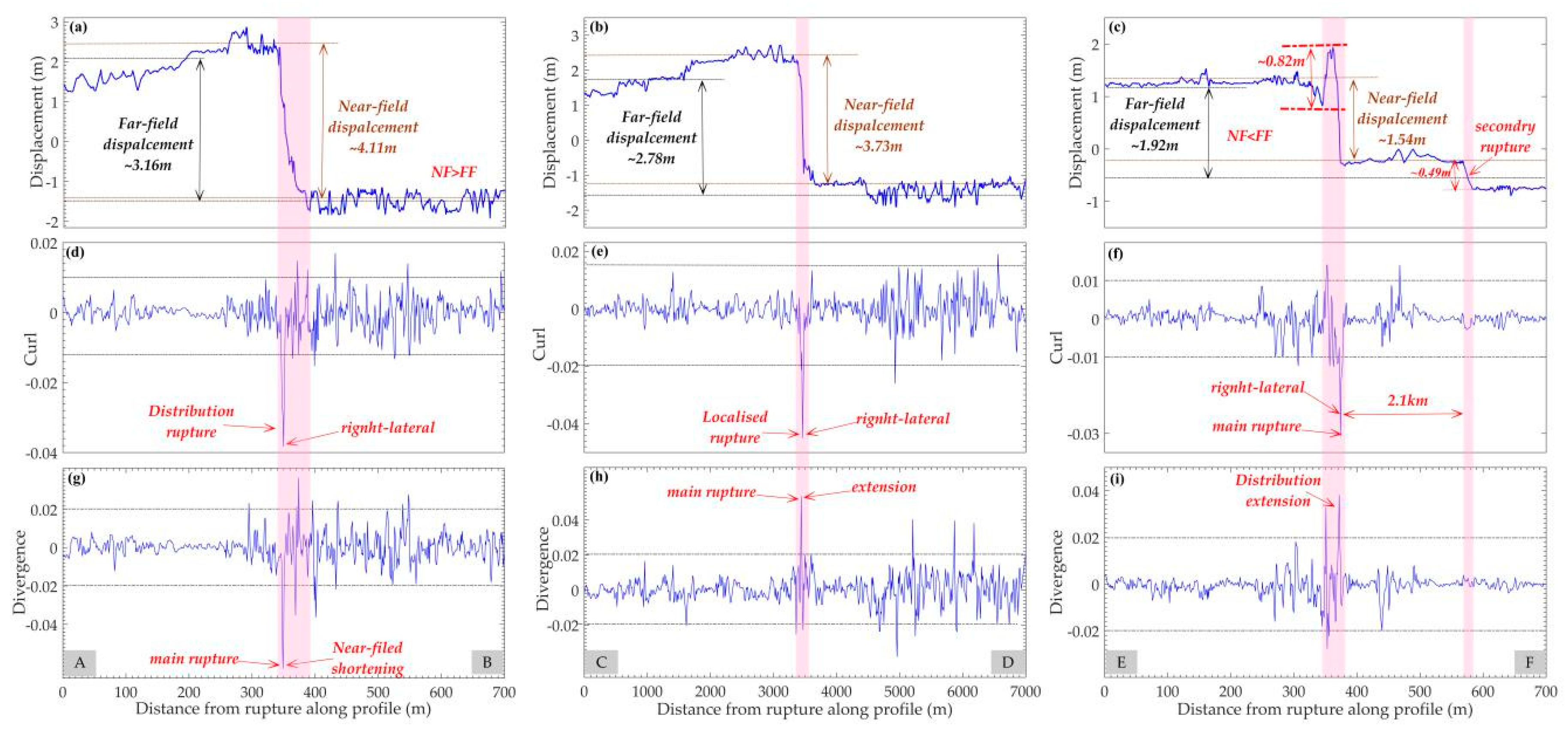
3. Revealing the Geometric Complexities of Ruptures by Curl and Divergence
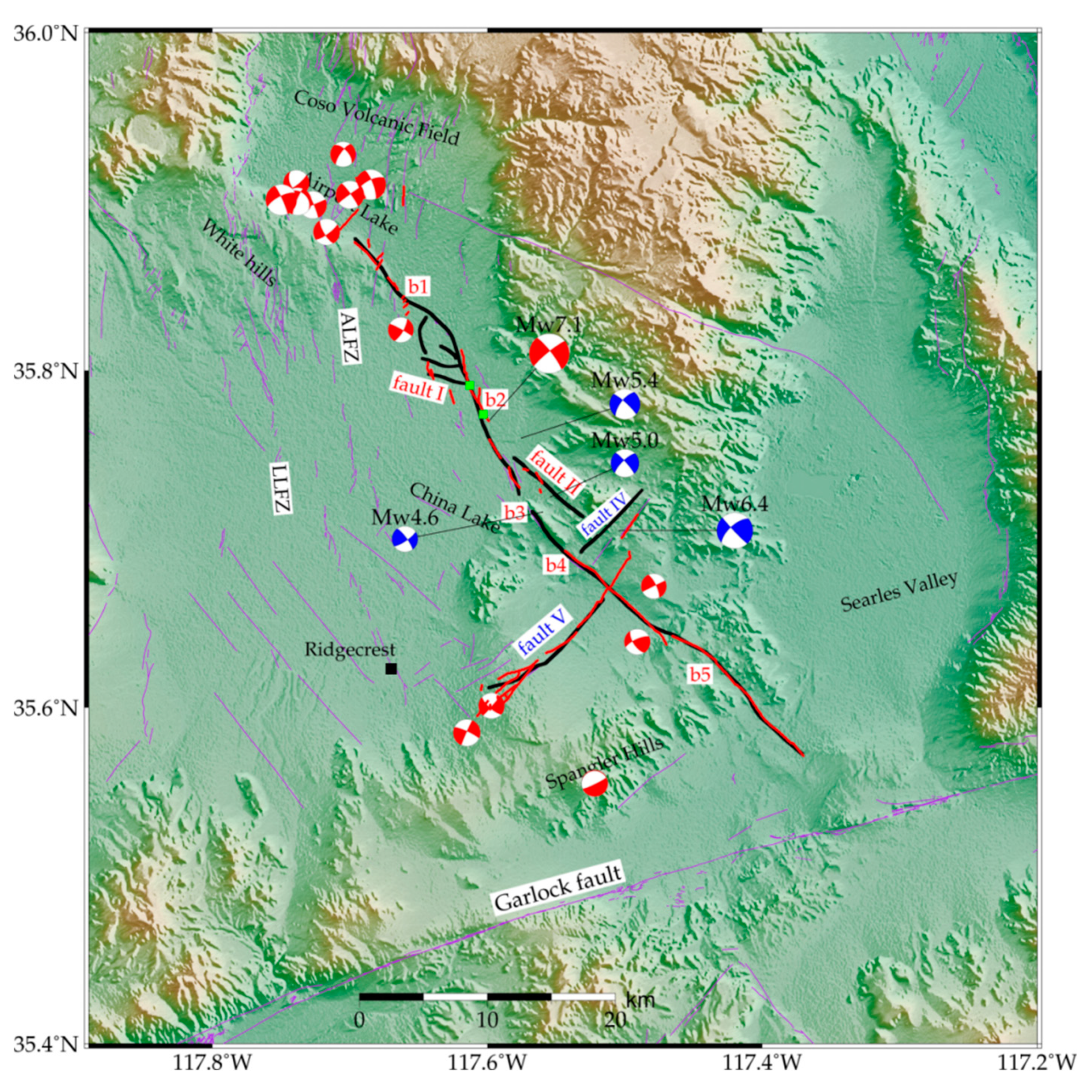
4. Kinematic Characteristics of the Coseismic Rupture
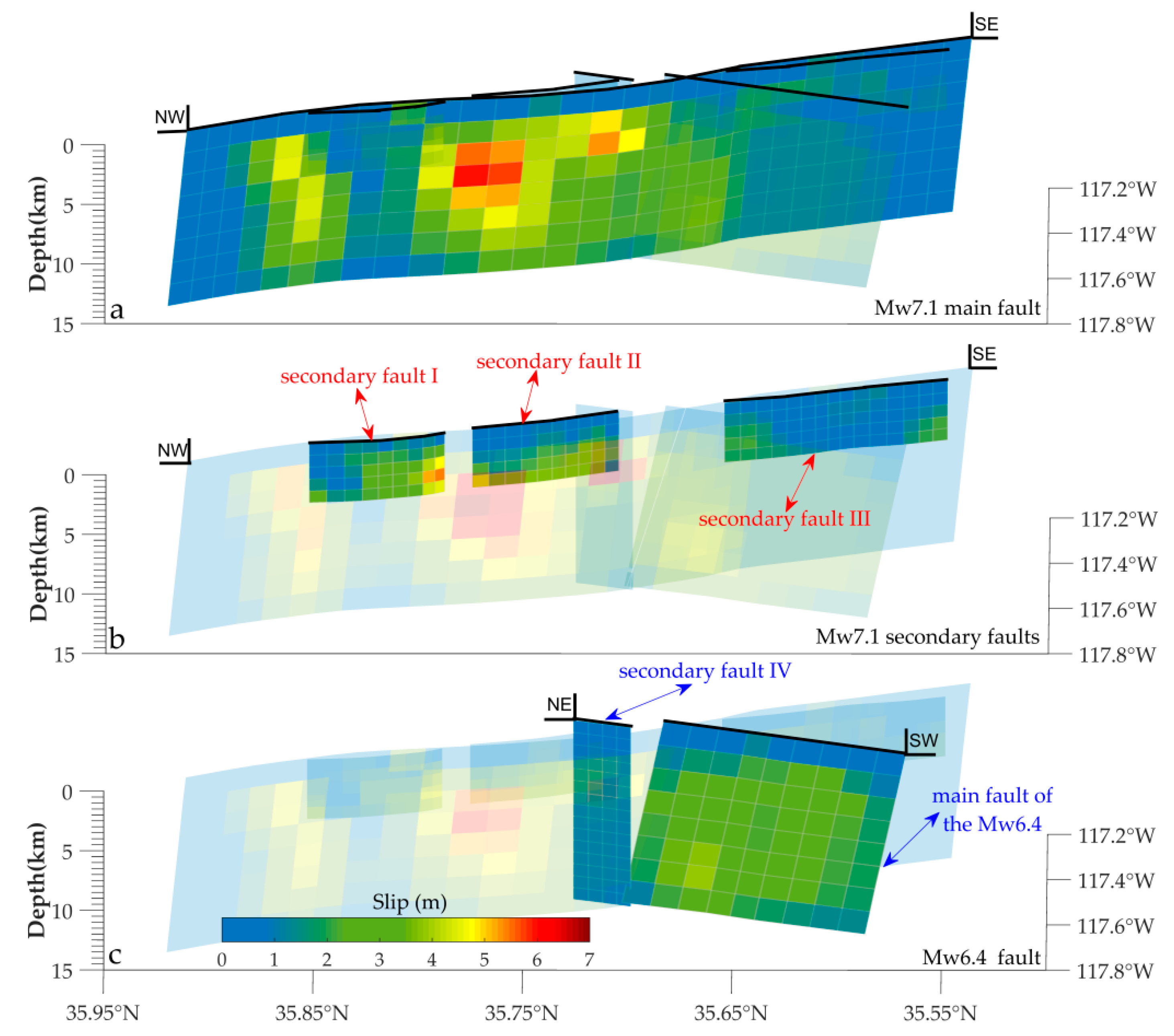
4.1. Multiple Faults Slip Distribution
4.2. Static Coulomb Stress Changes
5. Discussion
5.1. Multiple-Fault Slip Model
5.2. Cascading Rupture Process
6. Conclusions
Author Contributions
Funding
Acknowledgments
Conflicts of Interest
References
- Mw 6.4—11 km Southwest of Searles Valley, California 2019/07/04 17:33:49 (UTC). U.S. Geological Survey. 2019. Available online: https://earthquake.usgs.gov/earthquakes/eventpage/ci38443183/executive (accessed on 4 July 2019).
- Mw 7.1—2019 Ridgecrest Earthquake Sequence 2019/07/06 03:19:53 (UTC). U.S. Geological Survey. 2019. Available online: https://earthquake.usgs.gov/earthquakes/eventpage/ci38457511/executive (accessed on 6 July 2019).
- Mw 5.4—16 km West of Searles Valley, California 2019/07/05 11:07:53 (UTC). U.S. Geological Survey. 2019. Available online: https://earthquake.usgs.gov/earthquakes/eventpage/ci38450263/executive (accessed on 5 July 2019).
- Jones, L.E.; Hough, S.E. Analysis of broadband records from the 28 June 1992 Big Bear earthquake: Evidence of a multiple-event source. Bull. Seismol. Soc. Am. 1995, 85, 688–704. [Google Scholar]
- Rymer, M.J. The Hector Mine, California, Earthquake of 16 October 1999: Introduction to the Special Issue. Bull. Seismol. Soc. Am. 2002, 92, 1147–1153. [Google Scholar] [CrossRef]
- Jennings, C.W.; Bryant, W.A. Fault activity map of California, California Division of Mines and Geology, Geologic Data Map No. 6. Calif. Geol. Surv. 2010. [Google Scholar]
- Hudnut, K.W.; Seeber, L.; Pacheco, J. Cross-fault triggering in the November 1987 Superstition Hills Earthquake Sequence, southern California. Geophys. Res. Lett. 1989, 16, 199–202. [Google Scholar] [CrossRef]
- Larsen, S.; Reilinger, R.; Neugebauer, H.; Strange, W. GPS measurements of deformation associated with the 1987 Superstition Hills earthquake: Evidence for conjugate faulting. J. Geophys. Res. Solid Earth 1992, 97, 4885–4902. [Google Scholar] [CrossRef]
- Ross, Z.E.; Idini, B.; Jia, Z.; Stephenson, O.L.; Zhong, M.; Wang, X.; Zhan, Z.; Simons, M.; Fielding, E.J.; Yun, S.-H.; et al. Hierarchical interlocked orthogonal faulting in the 2019 Ridgecrest earthquake sequence. Science 2019, 366, 346–351. [Google Scholar] [CrossRef]
- Barnhart, W.D.; Hayes, G.P.; Gold, R.D. The July 2019 Ridgecrest, California Earthquake Sequence: Kinematics of Slip and Stressing in Cross-Fault Ruptures. Geophys. Res. Lett. 2019, 46, 11859–11867. [Google Scholar] [CrossRef]
- Nieto-Samaniego, A.F.; Alaniz-Alvarez, S.A. Influence of the structural framework on the origin of multiple fault patterns. J. Struct. Geol. 1995, 17, 1571–1577. [Google Scholar] [CrossRef]
- Massonnet, D.; Rossi, M.; Carmona, C.; Adragna, F.; Peltzer, G.; Feigl, K.; Rabaute, T. The displacement field of the Landers earthquake mapped by radar interferometry. Nature 1993, 364, 138–142. [Google Scholar] [CrossRef]
- Binet, R.; Bollinger, L. Horizontal Co-seismic deformation of the 2003 Bam (Iran) earthquake measured from SPOT-5 THR satellite imagery. Geophys. Res. Lett. 2005, 32, 287–294. [Google Scholar] [CrossRef]
- Vallage, A.; Klinger, Y.; Grandin, R.; Bhat, H.S.; Pierrot-Deseilligny, M. Inelastic surface deformation during the 2013 Mw 7.7 Balochistan, Pakistan, earthquake. Geology 2015, 43, 1079–1082. [Google Scholar]
- Zhou, Y.; Parsons, B.E.; Walker, R.T. Characterizing complex surface ruptures in the 2013 Mw 7.7 Balochistan earthquake using three-dimensional displacements. J. Geophys. Res. Solid Earth 2018, 123, 10191–10211. [Google Scholar] [CrossRef]
- Gold, R.D.; Reitman, N.G.; Briggs, R.W.; Barnhart, W.D.; Hayes, G.P.; Wilson, E. On- and off-fault deformation associated with the September 2013 Mw7.7 Balochistan earthquake: Implications for geologic slip rate measurements. Tectonophysics 2015, 660, 65–78. [Google Scholar] [CrossRef]
- Socquet, A.; Hollingsworth, J.; Pathier, E.; Bouchon, M. Evidence of supershear during the 2018 magnitude 7.5 Palu earthquake from space geodesy. Nat. Geosci. 2019, 12, 192–199. [Google Scholar] [CrossRef]
- Elliott, A.J.; Fletcher, J.M.; Fielding, E.J.; Gold, P.O.; Garcia, J.J.G.; Hudnut, K.W.; Liu-Zeng, J.; Teran, O.J. Near-field deformation from the El Mayor-Cucapah earthquake revealed by differential LIDAR. Science 2012, 335, 702–705. [Google Scholar]
- Hamling, I.J.; Hreinsdóttir, S.; Clark, K.; Elliott, J.; Liang, C.; Fielding, E.; Litchfifield, N.; Villamor, P.; Wallace, L.; Wright, T.J. Complex multifault rupture during the 2016 Mw 7.8 Kaikoura earthquake, New Zealand. Science 2017, 356, 7194. [Google Scholar] [CrossRef]
- Gascon, F.; Bouzinac, C.; Thépaut, O.; Jung, M.; Francesconi, B.; Louis, J.; Lonjou, V.; Lafrance, B.; Massera, S.; Gaudel-Vacaresse, A.; et al. Copernicus Sentinel-2A calibration and products validation status. Remote Sens. 2017, 9, 584. [Google Scholar] [CrossRef]
- Ayoub, F.; Leprince, S.; Avouac, J.P. Co-registration and correlation of aerial photographs for ground deformation measurements. ISPRS J. Photogramm. Remote Sens. 2009, 64, 551–560. [Google Scholar] [CrossRef]
- Leprince, S.; Ayoub, F.; Klinger, Y.; Avouac, J.P. Co-Registration of Optically Sensed Images and Correlation (COSI-Corr): An Operational Methodology for Ground Deformation Measurements. In Proceedings of the IEEE International Geoscience and Remote Sensing Symposium IGARSS, Barcelona, Spain, 23–27 July 2007. [Google Scholar] [CrossRef]
- Leprince, S.; Barbot, S.; Ayoub, F.; Avouac, J.P. Automatic and Precise Orthorectification, Coregistration, and Subpixel Correlation of Satellite Images, Application to Ground Deformation Measurements. IEEE Trans. Geosci. Remote Sens. 2007, 45, 1529–1558. [Google Scholar] [CrossRef]
- Rosu, A.M.; Pierrot-Deseilligny, M.; Delorme, A.; Binet, R.; Klinger, Y. Measurement of ground displacement from optical satellite image correlation using the free open-source software MicMac. ISPRS J. Photogramm. Remote Sens. 2015, 100, 48–59. [Google Scholar] [CrossRef]
- Rupnik, E.; Daakir, M.; Pierrot-Deseilligny, M. MicMac—A free, open-source solution for photogrammetry. Open Geospat. Data Softw. Stand. 2017, 2, 1–9. [Google Scholar] [CrossRef]
- Galland, O.; Bertelsen, H.S.; Guldstrand, F. Application of open-source photogrammetric software MicMac for monitoring surface deformation in laboratory models. J. Geophys. Res. Solid Earth 2016, 121, 2852–2872. [Google Scholar] [CrossRef]
- Werner, C.; Wegmüller, U.; Strozzi, T.; Wiesmann, A. GAMMA SAR and interferometric processing software. In Proceedings of the ERS ENVISAT Symposium, Gothenburg, Sweden, 16–20 October 2001; p. 1620. [Google Scholar]
- Farr, T.G.; Rosen, P.A.; Caro, E.; Crippen, R.; Duren, R.; Hensley, S.; Kobrick, M.; Paller, M.; Rodriguez, E.; Roth, L.; et al. The shuttle radar topography mission. Rev. Geophys. 2007, 45, RG2004. [Google Scholar] [CrossRef]
- Song, C.; Yu, C.; Li, Z.; Li, Y.; Xiao, R. Coseismic Slip Distribution of the 2019 Mw 7.5 New Ireland Earthquake from the Integration of Multiple Remote Sensing Techniques. Remote Sens. 2019, 11, 2767. [Google Scholar] [CrossRef]
- Goldstein, R.M.; Werner, C.L. Radar interferogram filtering for geophysical applications. Geophys. Res. Lett. 1998, 25, 4035–4038. [Google Scholar] [CrossRef]
- Werner, C.; Wegmuller, U.; Strozzi, T.; Wiesmann, A. Processing strategies for phase unwrapping for INSAR applications. Proc. Eur. Conf. Synth. Apert. Radar (EUSAR 2002) 2002, 1, 353–356. [Google Scholar]
- Tong, X.; Sandwell, D.T.; Smith-Konter, B. High-resolution interseismic velocity data along the San Andreas fault from GPS and InSAR. J. Geophys. Res. 2013, 118, 369–389. [Google Scholar] [CrossRef]
- Lohman, R.B.; Simons, M. Some thoughts on the use of InSAR data to constrain models of surface deformation: Noise structure and data downsampling. Geochem. Geophys. Geosyst. 2005, 6, 359–361. [Google Scholar] [CrossRef]
- Okada, Y. Surface deformation due to shear and tensile faults in a half-space. Bull. Seismol. Soc. Am. 1985, 75, 1135–1154. [Google Scholar]
- Wang, R.; Xia, Y.; Grosser, H.; Wetzel, H.U.; Kaufmann, H.; Zschau, J. The 2003 Bam (SE Iran) Earthquake: Precise Source Parameters from Satellite Radar Interferometry. Geophys. J. Int. 2004, 159, 917–922. [Google Scholar] [CrossRef]
- Lin, J.; Stein, R.S. Stress triggering in thrust and subduction earthquakes and stress interaction between the southern San Andreas and nearby thrust and strike-slip faults. J. Geophys. Res. 2004, 109, B02303. [Google Scholar] [CrossRef]
- Xu, C.; Wang, J.; Li, Z.; Drummond, J. Applying the Coulomb failure function with an optimally oriented plane to the 2008 Mw 7.9 Wenchuan earthquake triggering. Tectonophysics 2010, 491, 119–126. [Google Scholar] [CrossRef]
- Yu, C.; Li, Z.; Chen, J.; Hu, J.-C. Small magnitude co-seismic deformation of the 2017 Mw 6.4 Nyingchi earthquake revealed by InSAR measurements with atmospheric correction. Remote Sens. 2018, 10, 684. [Google Scholar] [CrossRef]
- Toda, S.; Stein, R.S.; Richards-Dinger, K.; Bozkurt, S.B. Forecasting the evolution of seismicity in southern California: Animations built on earthquake stress transfer. J. Geophys. Res. Solid Earth 2005, 110. [Google Scholar] [CrossRef]
- Levin, S.Z.; Sammis, C.G.; Bowman, D.D. An observational test of the stress accumulation model based on seismicity preceding the 1992 Landers, CA earthquake. Tectonophysics 2006, 413, 39–52. [Google Scholar] [CrossRef]
- Becker, T.W.; Hardebeck, J.L.; Anderson, G. Constraints on fault slip rates of the southern California plate boundary from GPS velocity and stress inversions. Geophys. J. R. Astron. Soc. 2005, 160, 634–650. [Google Scholar] [CrossRef]
- Freed, A.M.; Ali, S.T.; Bürgmann, R. Evolution of stress in Southern California for the past 200 years from coseismic, postseismic and interseismic stress changes. Geophys. J. R. Astron. Soc. 2007, 169, 1164–1179. [Google Scholar] [CrossRef]
- Mastro, P.; Serio, C.; Masiello, G.; Pepe, A. The MultipleAperture SAR Interferometry (MAI) Technique for the Detection of Large Ground Displacement Dynamics: An Overview. Remote Sens. 2020, 12, 1189. [Google Scholar] [CrossRef]
- Fan, W.Y.; Peter, M.S. Fault interactions and triggering during the 10 January 2012 Mw7.2 Sumatra earthquake. Geophys. Res. Lett. 2016, 43, 1934–1942. [Google Scholar] [CrossRef]
- Ide, S.; Aochi, H. Historical seismicity and dynamic rupture process of the 2011 Tohoku-Oki earthquake. Tectonophysics 2013, 600, 1–13. [Google Scholar] [CrossRef]
- Grocholski, B. Forecasting cascading fault rupture. Science 2016, 351, 1039–1040. [Google Scholar] [CrossRef][Green Version]
- Zhang, H.; Koper, K.D.; Pankow, K.; Ge, Z. Imaging the 2016 MW 7.8 Kaikoura, New Zealand Earthquake with Teleseismic P Waves: A Cascading Rupture Across Multiple Fault. Geophys. Res. Lett. 2017, 44, 4790–4798. [Google Scholar] [CrossRef]
- Fletcher, J.M.; Oskin, M.E.; Teran, O.J. The role of a keystone fault in triggering the complex El Mayor–Cucapah earthquake rupture. Nat. Geosci. 2016, 9, 303–307. [Google Scholar] [CrossRef]
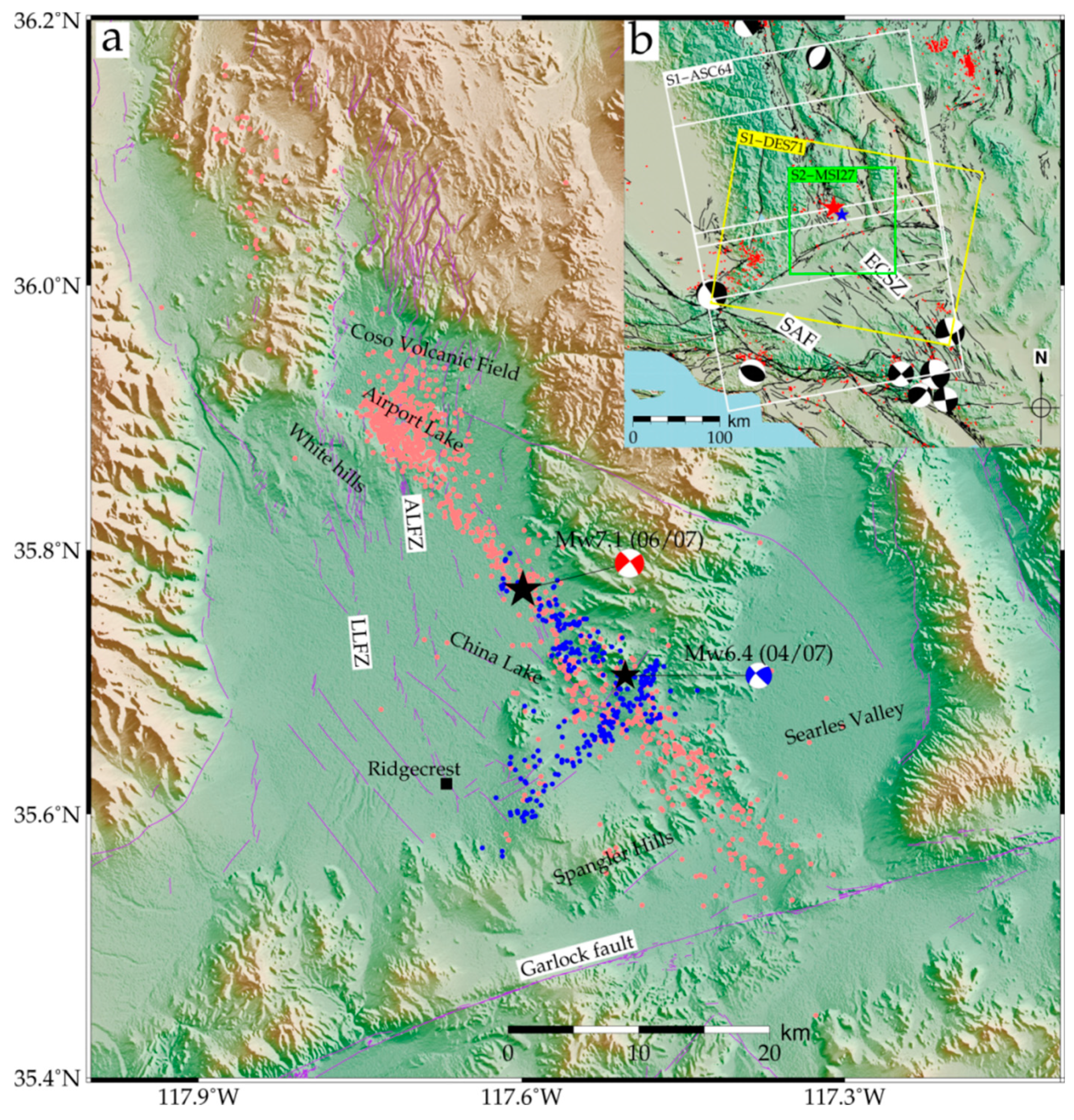
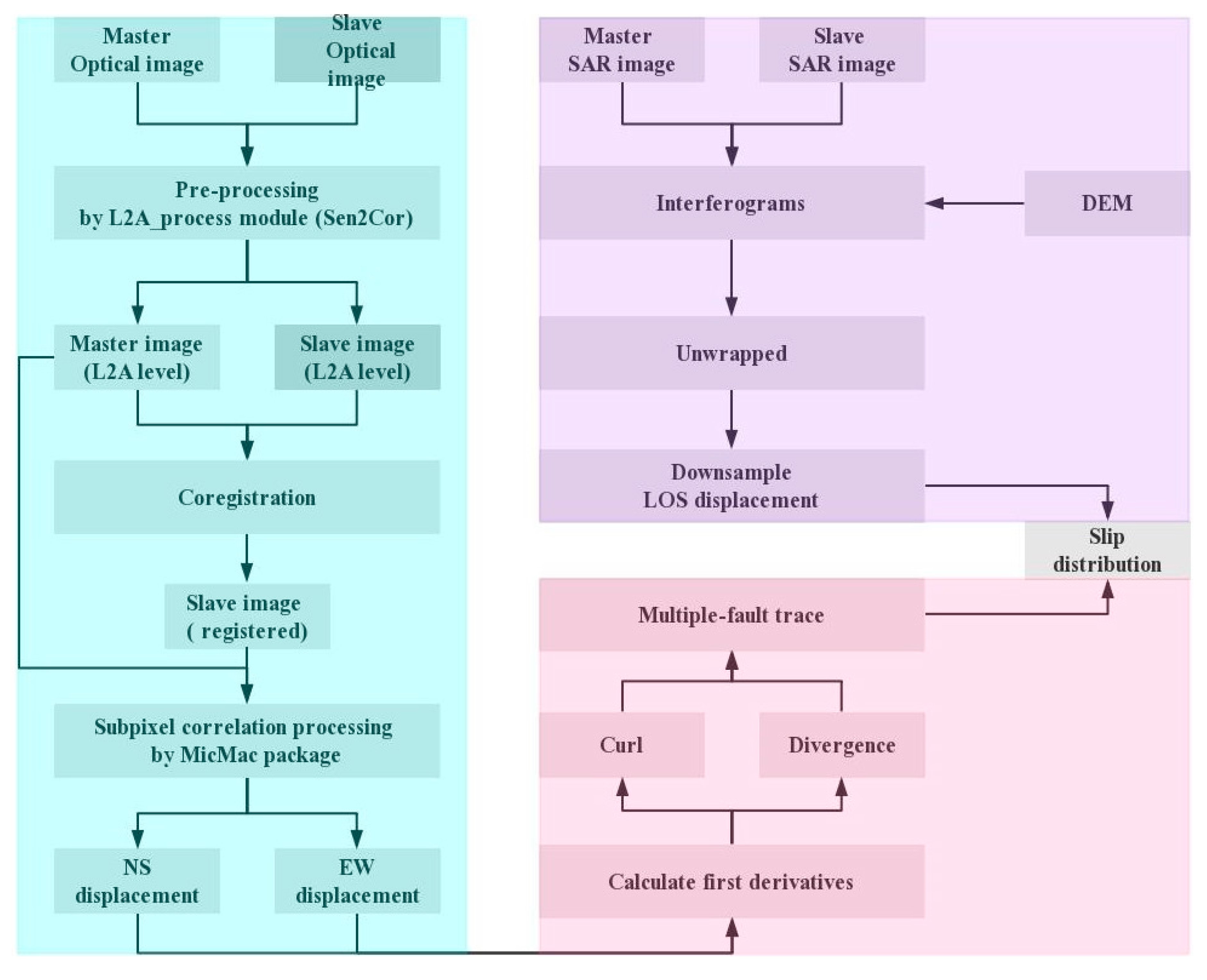
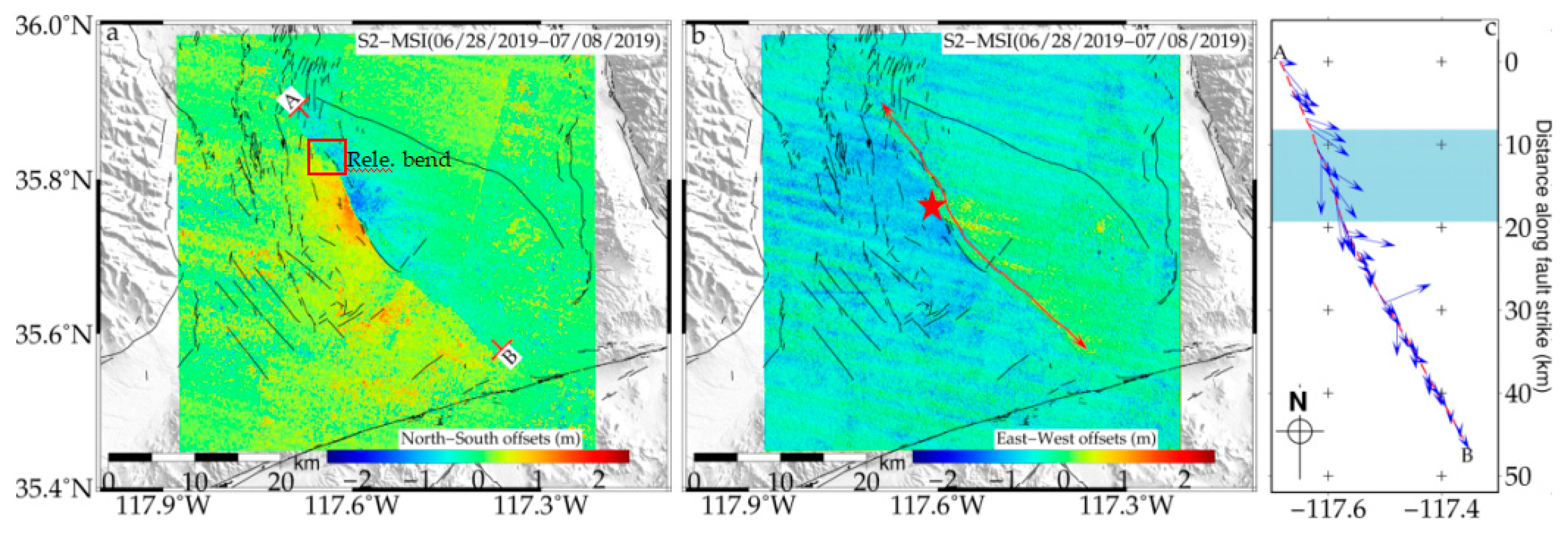

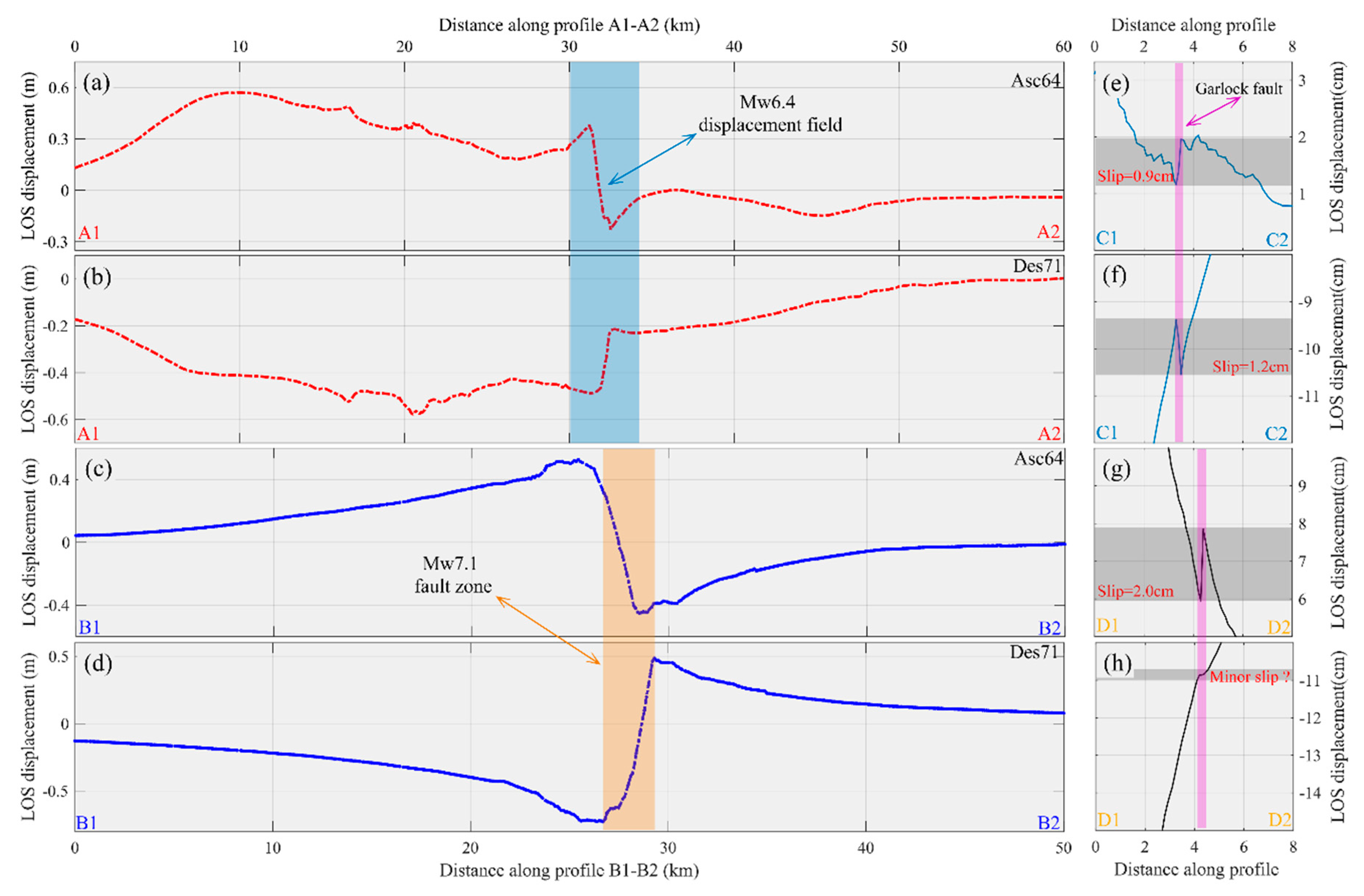

| Segment | Orientation (°N) | Length (km) | Strike (°) | Surface Rupture Kinematics | ||
|---|---|---|---|---|---|---|
| b1 | 35.7988–35.8825 | 16.4 | 315.5 | −0.0157 | 0.0047 | Right-lateral + minor vertical motion |
| b2 | 35.7305–35.7988 | 10.2 | 325.1 | −0.0291 | 0.0116 | Right-lateral + vertical motion |
| b3 | 35.7155–35.7305 | 2.3 | — | — | — | — |
| b4 | 35.6833–35.7155 | 4.7 | 321.2 | −0.0250 | 0.0103 | Right-lateral + vertical motion |
| b5 | 35.5774–35.6833 | 21.1 | 318.3 | −0.0052 | ≈0 | Minor right-lateral |
| fault I | — | — | 311.0 | — | — | Highly discontinuous ruptures |
| fault II | 35.7094–35.7460 | 6.0 | 311.7 | −0.0184 | ≈0 | Minor right-lateral |
Publisher’s Note: MDPI stays neutral with regard to jurisdictional claims in published maps and institutional affiliations. |
© 2020 by the authors. Licensee MDPI, Basel, Switzerland. This article is an open access article distributed under the terms and conditions of the Creative Commons Attribution (CC BY) license (http://creativecommons.org/licenses/by/4.0/).
Share and Cite
Li, C.; Zhang, G.; Shan, X.; Zhao, D.; Li, Y.; Huang, Z.; Jia, R.; Li, J.; Nie, J. Surface Rupture Kinematics and Coseismic Slip Distribution during the 2019 Mw7.1 Ridgecrest, California Earthquake Sequence Revealed by SAR and Optical Images. Remote Sens. 2020, 12, 3883. https://doi.org/10.3390/rs12233883
Li C, Zhang G, Shan X, Zhao D, Li Y, Huang Z, Jia R, Li J, Nie J. Surface Rupture Kinematics and Coseismic Slip Distribution during the 2019 Mw7.1 Ridgecrest, California Earthquake Sequence Revealed by SAR and Optical Images. Remote Sensing. 2020; 12(23):3883. https://doi.org/10.3390/rs12233883
Chicago/Turabian StyleLi, Chenglong, Guohong Zhang, Xinjian Shan, Dezheng Zhao, Yanchuan Li, Zicheng Huang, Rui Jia, Jin Li, and Jing Nie. 2020. "Surface Rupture Kinematics and Coseismic Slip Distribution during the 2019 Mw7.1 Ridgecrest, California Earthquake Sequence Revealed by SAR and Optical Images" Remote Sensing 12, no. 23: 3883. https://doi.org/10.3390/rs12233883
APA StyleLi, C., Zhang, G., Shan, X., Zhao, D., Li, Y., Huang, Z., Jia, R., Li, J., & Nie, J. (2020). Surface Rupture Kinematics and Coseismic Slip Distribution during the 2019 Mw7.1 Ridgecrest, California Earthquake Sequence Revealed by SAR and Optical Images. Remote Sensing, 12(23), 3883. https://doi.org/10.3390/rs12233883


