Applicability Evaluation of Multisource Satellite Precipitation Data for Hydrological Research in Arid Mountainous Areas


Abstract
1. Introduction
2. Materials and Methods
2.1. Study Area
2.2. Data Sources
2.2.1. Ground Reference Data
2.2.2. Satellite Precipitation Data
2.3. Statistical Evaluation Indicators of Precipitation
2.4. Hydrological Simulation Evaluation Index
2.4.1. Soil and Water Assessment Tool
2.4.2. Model Evaluation Indicators
3. Results
3.1. Comparison of the Spatial Distribution of Precipitation
3.1.1. Annual Precipitation
3.1.2. Seasonal Precipitation
3.2. Temporal Comparison of Precipitation
3.2.1. Annual-Scale Precipitation Accuracy Assessment
3.2.2. Seasonal Precipitation Accuracy Assessment
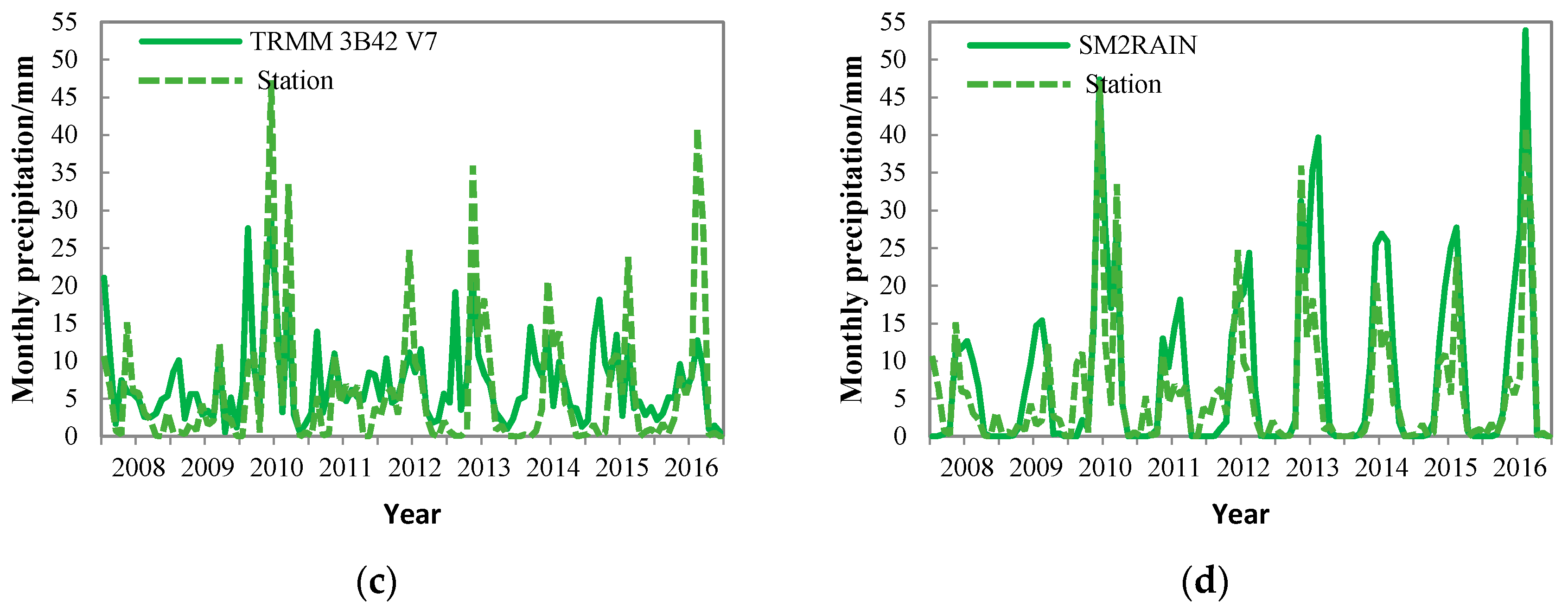
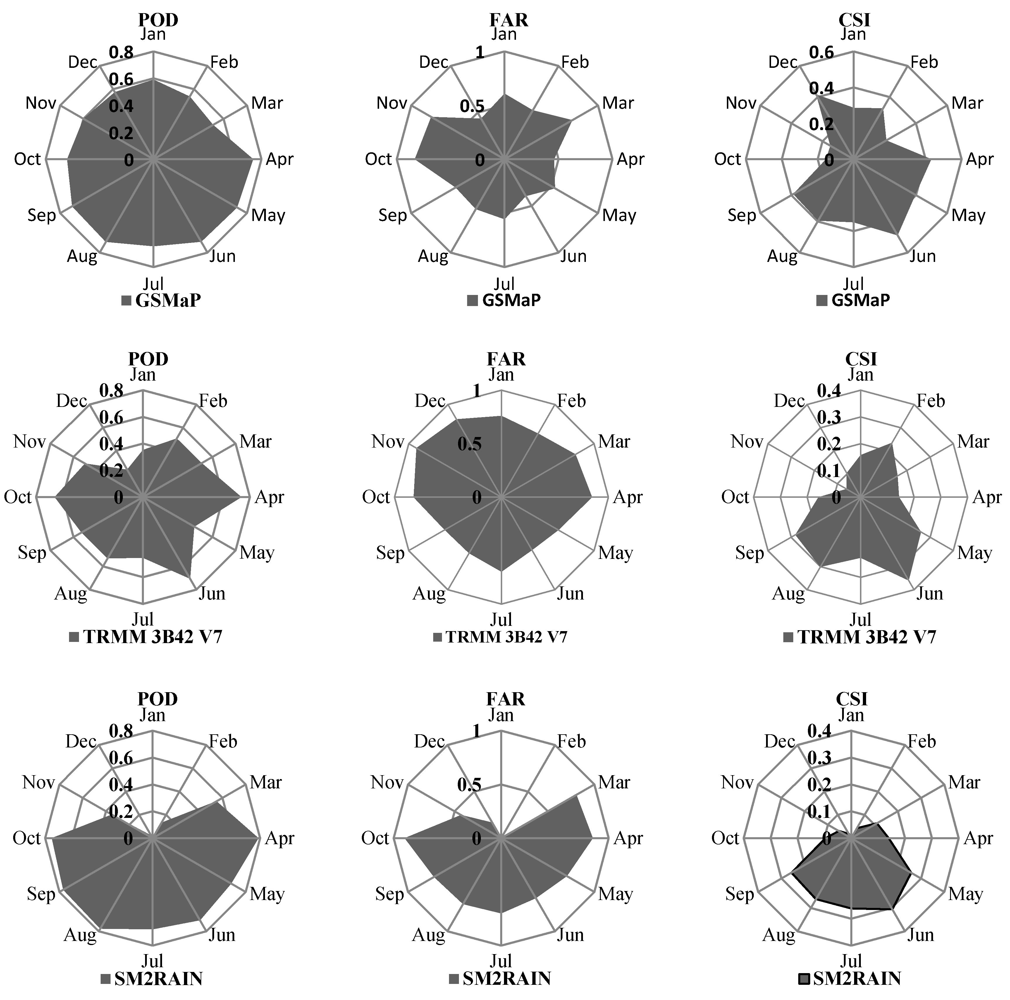
3.2.3. Monthly Scale Evaluation of Precipitation Accuracy
3.3. Evaluation of Runoff Simulation Accuracy
3.3.1. Monthly Runoff Simulation
3.3.2. Daily Runoff Simulation
4. Discussion
5. Conclusions
Author Contributions
Funding
Conflicts of Interest
References
- Blacutt, L.A.; Herdies, D.L.; de Gonçalves, L.G.G.; Vila, D.A.; Andrade, M. Precipitation comparison for the CFSR, MERRA, TRMM 3B42 and combined scheme datasets in Bolivia. Atmos. Res. 2015, 163, 117–131. [Google Scholar] [CrossRef]
- Kusangaya, S.; Toucher, M.L.W.; Van Garderen, E.A.; Jewitt, G.P.W. An evaluation of how downscaled climate data represents historical precipitation characteristics beyond the means and variances. Glob. Planet Chang. 2016, 144, 129–141. [Google Scholar] [CrossRef]
- Chen, H.; Yong, B.; Shen, Y.; Liu, J.; Hong, Y.; Zhang, J. Comparison analysis of six purely satellite-derived global precipitation estimates. J. Hydrol. 2020, 581, 124376. [Google Scholar] [CrossRef]
- Liao, R.; Zhang, D.; Shen, Y. Evaluation of the accuracy characteristics of 6 satellite precipitation products in China. Meteorology 2015, 41, 970–979. [Google Scholar]
- McDonnell, J.J.; Beven, K. Debates—The future of hydrological sciences: A (Common) path forward? A call to action aimed at understanding velocities, celerities and residence time distributions of the headwater hydrograph. Water Resour. Res. 2014, 50, 5342–5350. [Google Scholar] [CrossRef]
- Seibert, J.; Mcdonnell, J.J. On the dialog between experimentalist and modeler in catchment hydrology: Use of soft data for multicriteria model calibration. Water Resour. Res. 2002, 38, 1241–1252. [Google Scholar] [CrossRef]
- Tong, K.; Su, F.; Yang, D.; Hao, Z. Evaluation of satellite precipitation retrievals and their potential utilities in Hydrologic Modeling over the Tibetan Plateau. J. Hydrol. 2014, 519, 423–437. [Google Scholar] [CrossRef]
- Aslami, F.; Ghorbani, A.; Sobhani, B.; Esmali Ouri, A. Comprehensive comparison of daily IMERG and GSMaP satellite precipitation products in Ardabil Province, Iran. Int. J. Remote Sens. 2018, 40, 3139–3153. [Google Scholar] [CrossRef]
- Skaugen, T.; Andersen, J. Simulated precipitation fields with variance-consistent interpolation. Hydrol. Sci. J. 2010, 55, 676–686. [Google Scholar] [CrossRef]
- Wu, Z.; Zhang, Y.; Sun, Z.; Lin, Q.; He, H. Improvement of a combination of TMPA (or IMERG) and ground-based precipitation and application to a typical region of the East China Plain. Sci. Total Environ. 2018, 640–641, 1165–1175. [Google Scholar] [CrossRef]
- Katiraie-Boroujerdy, P.S.; Akbari Asanjan, A.; Hsu, K.L.; Sorooshian, S. Intercomparison of PERSIANN-CDR and TRMM-3B42V7 precipitation estimates at monthly and daily time scales. Atmos. Res. 2017, 193, 36–49. [Google Scholar] [CrossRef]
- Wu, Y.; Guo, L.; Zheng, H.; Zhang, B.; Li, M. Hydroclimate assessment of gridded precipitation products for the Tibetan Plateau. Sci. Total Environ. 2019, 660, 1555–1564. [Google Scholar] [CrossRef] [PubMed]
- Wu, L.; Zhai, P. Availability assessment of CMORPH and TRMM 3B42 in the analysis of warm-season hourly precipitation in the Sichuan basin and its east Sichuan basin. In Proceedings of the 28th Chinese Meteorological Society Annual Meeting, Xiamen, China, 2–4 November 2011. [Google Scholar]
- Tang, G.; Clark, M.P.; Papalexiou, S.M.; Ma, Z.; Hong, Y. Have satellite precipitation products improved over last two decades? A comprehensive comparison of GPM IMERG with nine satellite and reanalysis datasets. Remote Sens Environ. 2020, 240, 111697. [Google Scholar] [CrossRef]
- Zhang, L.; Li, X.; Cao, Y.; Nan, Z.; Wang, W.; Yingchun, G.; Penglong, W.; Yu, W. Evaluation and integration of the top-down and bottom-up satellite precipitation products over mainland China. J. Hydrol. 2019, 581, 124456. [Google Scholar] [CrossRef]
- Wu, L.; Xu, Y.; Wang, S. Comparison of TMPA-3B42RT legacy product and the equivalent IMERG products over mainland China. Remote Sens. 2018, 10, 1778. [Google Scholar] [CrossRef]
- Mohd Zad, S.; Zulkafli, Z.; Muharram, F. Satellite rainfall (TRMM 3B42 V7) performance assessment and adjustment over Pahang River basin, Malaysia. Remote Sens. 2018, 10, 388. [Google Scholar] [CrossRef]
- Jiang, Q.; Li, W.; Wen, J.; Qiu, C.; Sun, W.; Fang, Q.; Xu, M.; Tan, J. Accuracy evaluation of two high-resolution satellite-based rainfall products: TRMM 3B42 V7 and CMORPH in Shanghai. Water 2018, 10, 40. [Google Scholar] [CrossRef]
- Xu, R.; Tian, F.; Yang, L.; Hu, H.; Lu, H.; Hou, A. Ground validation of GPM IMERG and TRMM 3B42 V7 rainfall products over southern Tibetan Plateau based on a high-density rain gauge network. J. Geophys. Res. Atmos. 2017, 122, 910–924. [Google Scholar] [CrossRef]
- Jiang, S.; Ren, L.; Yong, B.; Hong, Y.; Yang, X.; Yuan, F. Evaluation of latest TMPA and CMORPH precipitation products with independent rain gauge observation networks over high-latitude and low-latitude basins in China. Chin. Geogr. Sci. 2016, 26, 439–455. [Google Scholar] [CrossRef]
- Cai, Y.; Jin, C.; Wang, A.; Guan, D.; Wu, J.; Yuan, F.; Xu, L. Comprehensive precipitation evaluation of TRMM 3B42 with dense rain gauge networks in a Mid-latitude basin, northeast, China. Theor. Appl. Climatol. 2016, 126, 659–671. [Google Scholar] [CrossRef]
- Gebere, S.; Alamirew, T.; Merkel, B.; Melesse, A. Performance of high resolution satellite rainfall products over data scarce parts of Eastern Ethiopia. Remote Sens. 2015, 7, 11639–11663. [Google Scholar] [CrossRef]
- Belete, M.; Deng, J.; Wang, K.; Zhou, M.; Zhu, E.; Shifaw, E.; Bayissa, Y. Evaluation of satellite rainfall products for modeling water yield over the source region of Blue Nile basin. Sci. Total Environ. 2020, 708, 134834. [Google Scholar] [CrossRef]
- Xue, X.; Hong, Y.; Limaye, A.S.; Gourley, J.J.; Huffman, G.J.; Khan, S.I.; Dorji, C.; Chen, S. Statistical and hydrological evaluation of TRMM-based Multi-satellite Precipitation Analysis over the Wangchu Basin of Bhutan: Are the latest satellite precipitation products 3B42V7 ready for use in ungauged basins? J. Hydrol. 2013, 499, 91–99. [Google Scholar] [CrossRef]
- Lu, D.; Yong, B. A preliminary assessment of the gauge-adjusted near-real-time GSMaP precipitation estimate over mainland China. Remote Sens. 2020, 12, 141. [Google Scholar] [CrossRef]
- Deng, P.; Zhang, M.; Guo, H.; Xu, C.; Bing, J.; Jia, J. Error analysis and correction of the daily GSMaP products over Hanjiang River basin of China. Atmos. Res. 2018, 214, 121–134. [Google Scholar] [CrossRef]
- Gao, F.; Zhang, Y.; Chen, Q.; Wang, P.; Yang, H.; Yao, Y.; Cai, W. Comparison of two long-term and high-resolution satellite precipitation datasets in Xinjiang, China. Atmos. Res. 2018, 212, 150–157. [Google Scholar] [CrossRef]
- Shawky, M.; Moussa, A.; Hassan, Q.; El-Sheimy, N. Performance assessment of sub-daily and daily precipitation estimates derived from GPM and GSMaP products over an arid environment. Remote Sens. 2019, 11, 2840. [Google Scholar] [CrossRef]
- Shukla, S.; Funk, C.; Peterson, P.; Mcnally, A.; Dinku, T.; Barbosa, H.; Paredestrejo, F.; Pedreros, D.; Husak, G. The Climate Hazards Group InfraRed Precipitation with Stations (CHIRPS) Dataset and Its Applications in Drought Risk Management. In Proceedings of the EGU General Assembly 2017, Vienna, Austria, 23–28 April 2017. [Google Scholar]
- Peterson, P.; Funk, C.; Landsfeld, M.; Husak, G.; Pedreros, D.; Verdin, J.; Rowland, J.; Shukla, S.; McNally, A.; Michaelsen, J.; et al. The Climate Hazards Group InfraRed Precipitation with Stations (CHIRPS) v2.0 Dataset: 35 Year Quasi-Global Precipitation Estimates for Drought Monitoring. In Proceedings of the American Geophysical Union’s 48th annual Fall Meeting, San Francisco, CA, USA, 14–18 December 2015. [Google Scholar]
- Aksu, H.; Akgül, M.A. Performance evaluation of CHIRPS satellite precipitation estimates over Turkey. Theor. Appl. Climatol. 2020, 17, 1–4. [Google Scholar]
- Ayehu, G.; Tadesse, T.; Awoke, B.; Dinku, T. Validation of new satellite rainfall products over the upper Blue Nile basin, Ethiopia. Atmos Meas Tech. 2018, 11, 1921–1936. [Google Scholar] [CrossRef]
- Ehtsham, M.; Waseem, M.; Ahmad, I.; Khan, N.; Chen, S. Satellite precipitation product: Applicability and accuracy evaluation in diverse region (SM2RAIN). Sci. China Technol. Sci. 2019, 63, 819–828. [Google Scholar]
- Satge, F.; Hussain, Y.; Molina-Carpio, J.; Pillco, R.; Laugner, C.; Akhter, G.; Bonnet, M.P. Reliability of SM2RAIN precipitation datasets in comparison to gauge observations and hydrological modelling over arid regions. Int. J. Climatol. 2020. [Google Scholar] [CrossRef]
- Wu, J.; Lin, B.; Shao, Y. Application of regional linear moment method to rainstorm frequency analysis in Taihu Lake basin. Hydrology 2015, 35, 15–22. [Google Scholar]
- Brocca, L.; Filippucci, P.; Hahn, S.; Ciabatta, L.; Massari, C.; Camici, S.; Schüller, L.; Bojkov, B.; Wagner, W. SM2RAIN–ASCAT (2007–2018): Global daily satellite rainfall data from Ascat soil moisture observations. Earth Syst. Sci. Data 2019, 11, 1583–1601. [Google Scholar] [CrossRef]
- Xu, F.; Guo, B.; Ye, B.; Ye, Q.; Chen, H.; Ju, X.; Guo, J.; Wang, Z. Systematical evaluation of GPM IMERG and TRMM 3B42 V7 precipitation products in the Huang-Huai-Hai Plain, China. Remote Sens. 2019, 11, 697. [Google Scholar] [CrossRef]
- Chiaravalloti, F.; Brocca, L.; Procopio, A.; Massari, C.; Gabriele, S. Assessment of GPM and SM2RAIN-Ascat rainfall products over complex terrain in Southern Italy. Atmos. Res. 2018, 206, 64–74. [Google Scholar] [CrossRef]
- Kan, B.; Su, F.; Tong, K.; Zhang, L. Applicability analysis of four precipitation data in the upper reaches of the Yeerqiang River in the Karakorum Mountains. Glacier Permafrost. 2013, 3, 710–722. [Google Scholar]
- Ye, T.; Duan, Z.; Disse, M.; Chiogna, G. Evaluation of Precipitation Input for SWAT Modeling in Alpine Catchment: A Case Study in the Adige River Basin (Italy). Sci. Total Environ. 2016, 573, 66–82. [Google Scholar]
- Liu, X. Imulation of Hydrological Effects of Climate and Land Use Change in the Upper Hotan River Based on SWAT Model. Master’s Thesis, Qufu Normal University, Rizhao, China, 11 June 2019. [Google Scholar]
- Zhou, X.; AbdulRahman, H. Research on the impact of climate change on the runoff of Hotan River. China Rural Water Hydropower 2017, 3, 21–25. [Google Scholar]
- Funk, C.; Peterson, P.; Landsfeld, M.; Pedreros, D.; Verdin, J.; Shukla, S.; Husak, G.; Rowland, J.; Harrison, L.; Hoell, A. The Climate Hazards Infrared Precipitation with Stations—A new environmental record for monitoring extremes. Sci. Data 2015, 2, 150066. [Google Scholar] [CrossRef]
- Funk, C.C.; Peterson, P.J.; Landsfeld, M.F.; Pedreros, D.H.; Verdin, A.P. A quasi-global precipitation time series for drought monitoring data series 832. US Geol. Surv. Data Ser. 2014, 832, 1–2. [Google Scholar]
- Setiawati, M.D.; Miura, F. Evaluation of Gsmap daily rainfall satellite data for flood monitoring: Case study—Kyushu Japan. Hydrol. Earth Syst. Sci. 2016, 4, 101. [Google Scholar] [CrossRef]
- Deng, P.; Zhang, M.; Bing, J.; Jia, J.; Zhang, D. Evaluation of the GSMaP_Gauge products using rain gauge observations and SWAT model in the upper Hanjiang River basin. Atmos. Res. 2019, 219, 153–165. [Google Scholar] [CrossRef]
- Huffman, G.J.; Bolvin, D.T.; Nelkin, E.J.; Wolff, D.B.; Adler, R.F.; Gu, G.; Hong, Y.; Bowman, K.P.; Stocker, E.F. The TRMM Multisatellite Precipitation Analysis (TMPA): Quasi-global, multiyear, combined-sensor precipitation estimates at fine scales. J. Hydrometeorol. 2007, 8, 38–55. [Google Scholar] [CrossRef]
- Huffman, G.J.; Bolvin, D.T. TRMM and Other Data Precipitation Data Set Documentation; NASA: Washington, DC, USA, 2015. [Google Scholar]
- Guo, H.; Chen, S.; Bao, A.; Behrangi, A.; Hong, Y.; Ndayisaba, F.; Hu, J.; Stepanian, P.M. Early assessment of integrated multi-satellite retrievals for global precipitation measurement over China. Atmos. Res. 2016, 176–177, 121–133. [Google Scholar] [CrossRef]
- Trejo, F.J.P.; Barbosa, H.A.; Peñaloza-Murillo, M.A.; Moreno, M.A.; Farías, A. Intercomparison of improved satellite rainfall estimation with CHIRPS gridded product and rain gauge data over Venezuela. Atmósfera 2016, 29, 323–342. [Google Scholar] [CrossRef]
- Jin, X.; Jin, Y.; Yuan, D.; Mao, X. Effects of land-use data resolution on hydrologic modelling, a case study in the upper reach of the Heihe River, Northwest China. Ecol. Model. 2019, 404, 61–68. [Google Scholar] [CrossRef]
- Li, Z.; Shao, Q.; Xu, Z.; Cai, X. Analysis of parameter uncertainty in semi-distributed hydrological models using bootstrap method: A case study of SWAT model applied to Yingluoxia Watershed in Northwest China. J. Hydrol. 2010, 385, 76–83. [Google Scholar] [CrossRef]
- Luo, Y.; Arnold, J.; Liu, S.; Wang, X.; Chen, X. Inclusion of glacier processes for distributed hydrological modeling at basin scale with application to a watershed in Tianshan Mountains, Northwest China. J. Hydrol. 2013, 477, 72–85. [Google Scholar] [CrossRef]
- Geng, H.; Pan, B.; Huang, B.; Cao, B.; Gao, H. The spatial distribution of precipitation and topography in the Qilian Shan Mountains, northeastern Tibetan Plateau. Geomorphology 2017, 297, 43–54. [Google Scholar] [CrossRef]
- Zhang, D.; Zhou, S. Quantitative analysis of the impact of the No. 1 glacier in the headwaters of the Urumqi River in the Tianshan Mountains on precipitation. Glacial Frozen Soil. 2000, 3, 243–249. [Google Scholar]
- Hu, S. Hotan River basin hydrological characteristics and regional water resources evaluation. Arid Area Res. 1991, 2, 59–74. [Google Scholar]
- Yang, Z. Glacier water resources of China. Nat. Resour. 1991, 1, 46–55. [Google Scholar]
- Collischonn, B.; Collischonn, W.; Tucci, C.E.M. Daily hydrological modeling in the Amazon basin using TRMM rainfall estimates. J. Hydrol. 2008, 360, 207–216. [Google Scholar] [CrossRef]
- Draper, D.; Newell, D.; Wentz, F.; Krimchansky, S.; Jackson, G. The Global Precipitation Measurement (GPM) Microwave Imager (GMI): Instrument overview and early on-orbit performance. IEEE J. Sel. Top. Appl. Earth Obs. Remote Sens. 2015, 8, 3452–3462. [Google Scholar] [CrossRef]
- Paredes-Trejo, F.; Barbosa, H.A.; Rossato Spatafora, L. Assessment of SM2RAIN-derived and state-of-the-Art satellite rainfall products over Northeastern Brazil. Remote Sens. 2018, 10, 1093. [Google Scholar] [CrossRef]
- Rahman, K.U.; Shang, S.; Shahid, M.; Wen, Y. Performance Assessment of SM2RAIN-CCI and SM2RAIN-ASCAT precipitation products over Pakistan. Remote Sens. 2019, 11, 2040. [Google Scholar] [CrossRef]
- Wolff, D.; Marks, D.; Amitai, E.; Silberstein, D.; Fisher, B.; Tokay, A.; Wang, J.; Pippitt, J. Ground validation for the Tropical Rainfall Measuring Mission (TRMM). J. Atmos. Ocean Technol. 2005, 22, 365–380. [Google Scholar] [CrossRef]


| Serial Number | Station Name | East Longitude/E | North Latitude/N | Altitude/m | Observation Station Attributes | Temperature, Precipitation/Runoff Data Period |
|---|---|---|---|---|---|---|
| 1 | Hotan (HT) | 79.93 | 37.13 | 1375 | weather station | 2008–2016 |
| 2 | Pishan (PS) | 78.28 | 37.62 | 1375.4 | weather station | 2008–2016 |
| 3 | Tashkurgan (TS) | 75.23 | 37.77 | 3090 | weather station | 2008–2016 |
| 4 | Shache (SC) | 77.27 | 38.43 | 1231 | weather station | 2008–2016 |
| 5 | Yutian (YT) | 81.65 | 36.85 | 1422 | weather station | 2008–2016 |
| 6 | Uluwati | 79.43 | 36.87 | hydrological station | monthly runoff 2008–2016 | |
| daily runoff 2008 |
| Precipitation Data | Time Resolution | Spatial Resolution | Coverage Area | Time Series Data Available | The Time Series Data Used |
|---|---|---|---|---|---|
| CHIRPS | 1 day | 0.05° | 50° N–50° S | 1981–now | 2008–2016 |
| GSMaP | 1 h | 0.1° | 60° N–60° S | 2000–now | 2008–2016 |
| TRMM 3B42 V7 | 3 h | 0.25° | 50° N–50° S | 1998–now | 2008–2016 |
| SM2RAIN-ASCAT | 1 day | 0.11° | Global (land only) | 2007–2019.8 | 2008–2016 |
| Precipitation Product | Spring | Summer | Autumn | Winter | Annual Average Precipitation/mm | ||||
|---|---|---|---|---|---|---|---|---|---|
| Precipitation/mm | Percentage/% | Precipitation/mm | Percentage/% | Precipitation/mm | Percentage/% | Precipitation/mm | Percentage/% | ||
| Station | 15.74 | 22.12 | 36.51 | 51.32 | 12.51 | 17.58 | 6.39 | 8.98 | 71.15 |
| CHIRPS | 82.02 | 38.92 | 59.94 | 28.44 | 23.05 | 10.94 | 45.75 | 21.71 | 210.76 |
| GSMaP | 24.13 | 24.85 | 41.22 | 42.45 | 11.58 | 11.93 | 20.17 | 20.78 | 97.11 |
| TRMM 3B42 V7 | 50.66 | 33.04 | 44.85 | 29.25 | 23.54 | 15.35 | 34.26 | 22.35 | 153.31 |
| SM2RAIN | 12.66 | 8.18 | 126.22 | 81.52 | 15.45 | 9.98 | 0.50 | 0.32 | 154.83 |
| Data | Spring (BIAS%) | Summer (BIAS%) | Autumn (BIAS%) | Winter (BIAS%) |
|---|---|---|---|---|
| CHIRPS | 94.34% | 54.00% | 29.30% | 162.98% |
| GSMaP | 3.92% | 8.06% | 1.25% | 97.05% |
| TRMM 3B42 V7 | 54.50% | 31.21% | 22.82% | 211.58% |
| SM2RAIN | 1.01% | 88.02% | 16.56% | 78.61% |
| Data | R | RMSD/mm | BIAS% |
|---|---|---|---|
| CHIRPS | 0.43 | 8.06 | 1.75% |
| GSMaP | 0.82 | 5.45 | 5.50% |
| TRMM 3B42 V7 | 0.63 | 6.89 | 19.48% |
| SM2RAIN | 0.81 | 6.67 | 39.01% |
| Precipitation Product | NS | PBIAS | R2 |
|---|---|---|---|
| CHIRPS | 0.29 | 10.18% | 0.47 |
| GSMaP | 0.25 | 63.39% | 0.67 |
| TRMM | 0.23 | 58.76% | 0.50 |
| SM2RAIN | 0.42 | 63.00% | 0.89 |
© 2020 by the authors. Licensee MDPI, Basel, Switzerland. This article is an open access article distributed under the terms and conditions of the Creative Commons Attribution (CC BY) license (http://creativecommons.org/licenses/by/4.0/).
Share and Cite
Wang, X.; Li, B.; Chen, Y.; Guo, H.; Wang, Y.; Lian, L. Applicability Evaluation of Multisource Satellite Precipitation Data for Hydrological Research in Arid Mountainous Areas. Remote Sens. 2020, 12, 2886. https://doi.org/10.3390/rs12182886
Wang X, Li B, Chen Y, Guo H, Wang Y, Lian L. Applicability Evaluation of Multisource Satellite Precipitation Data for Hydrological Research in Arid Mountainous Areas. Remote Sensing. 2020; 12(18):2886. https://doi.org/10.3390/rs12182886
Chicago/Turabian StyleWang, Xiangzhen, Baofu Li, Yaning Chen, Hao Guo, Yunqian Wang, and Lishu Lian. 2020. "Applicability Evaluation of Multisource Satellite Precipitation Data for Hydrological Research in Arid Mountainous Areas" Remote Sensing 12, no. 18: 2886. https://doi.org/10.3390/rs12182886
APA StyleWang, X., Li, B., Chen, Y., Guo, H., Wang, Y., & Lian, L. (2020). Applicability Evaluation of Multisource Satellite Precipitation Data for Hydrological Research in Arid Mountainous Areas. Remote Sensing, 12(18), 2886. https://doi.org/10.3390/rs12182886