ALS-Based Detection of Past Human Activities in the Białowieża Forest—New Evidence of Unknown Remains of Past Agricultural Systems

 ,
,  , , , , , , and
Abstract
1. Introduction
2. Materials and Methods
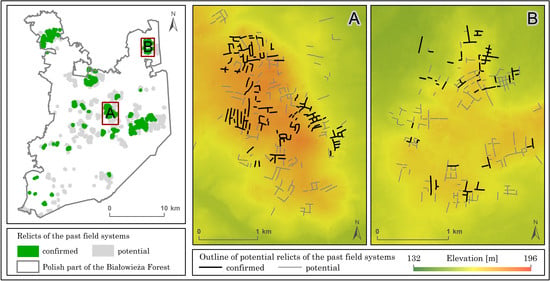
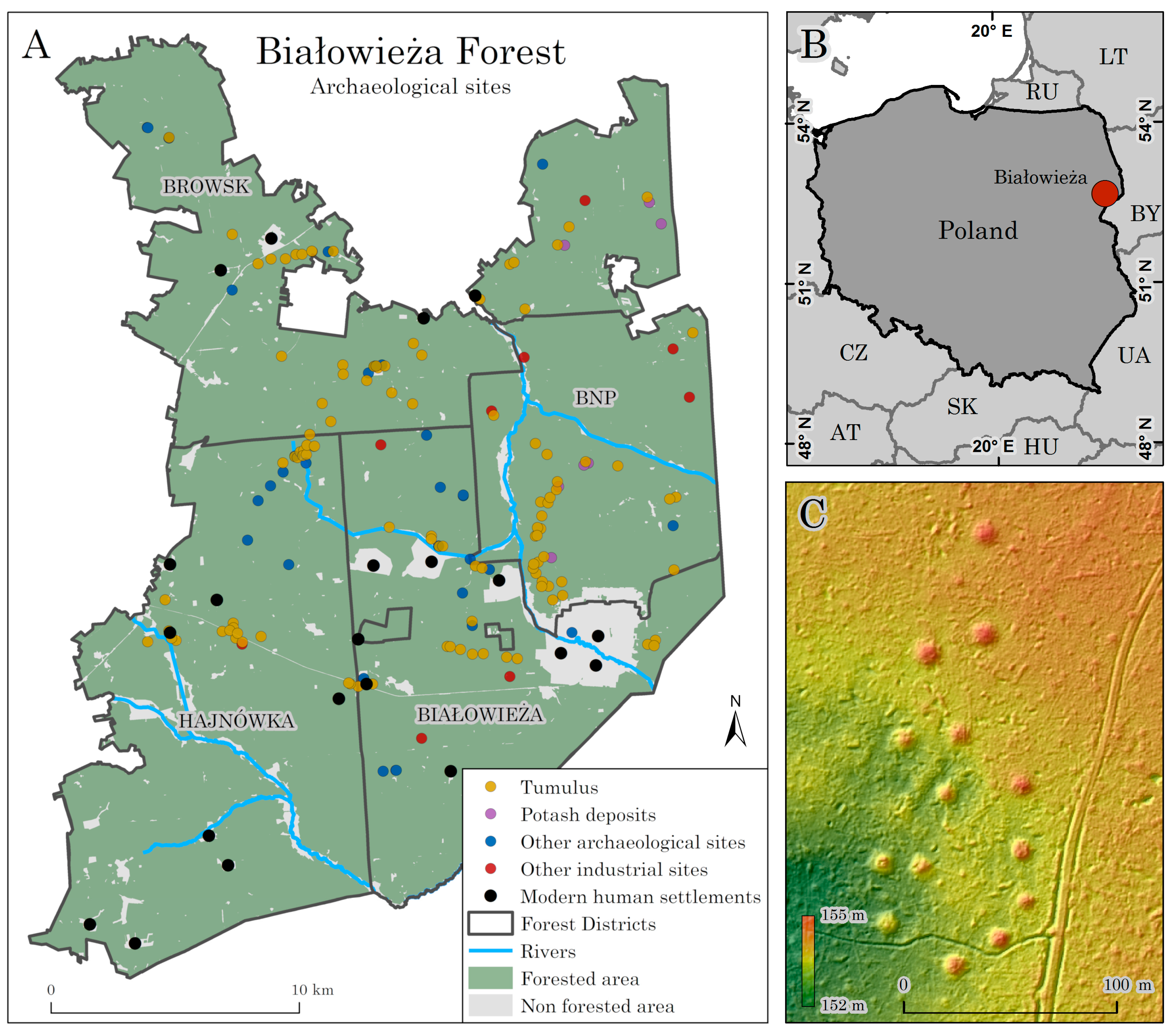
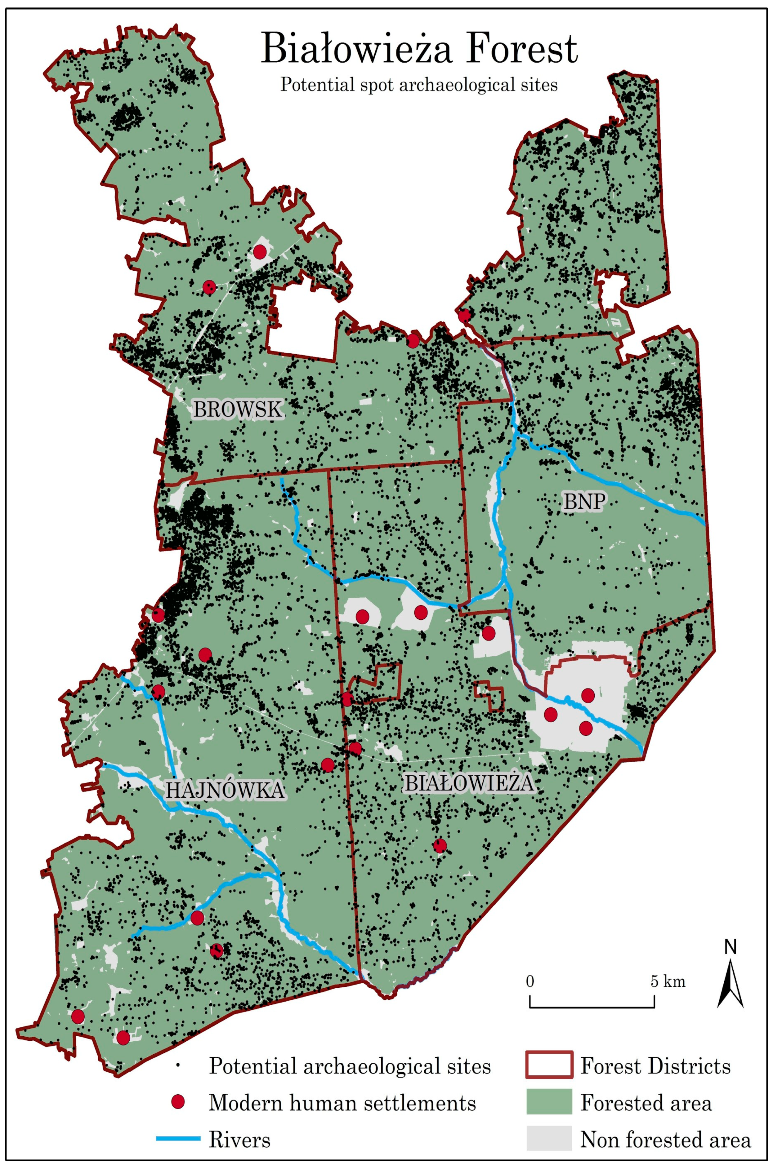
2.1. Study Area
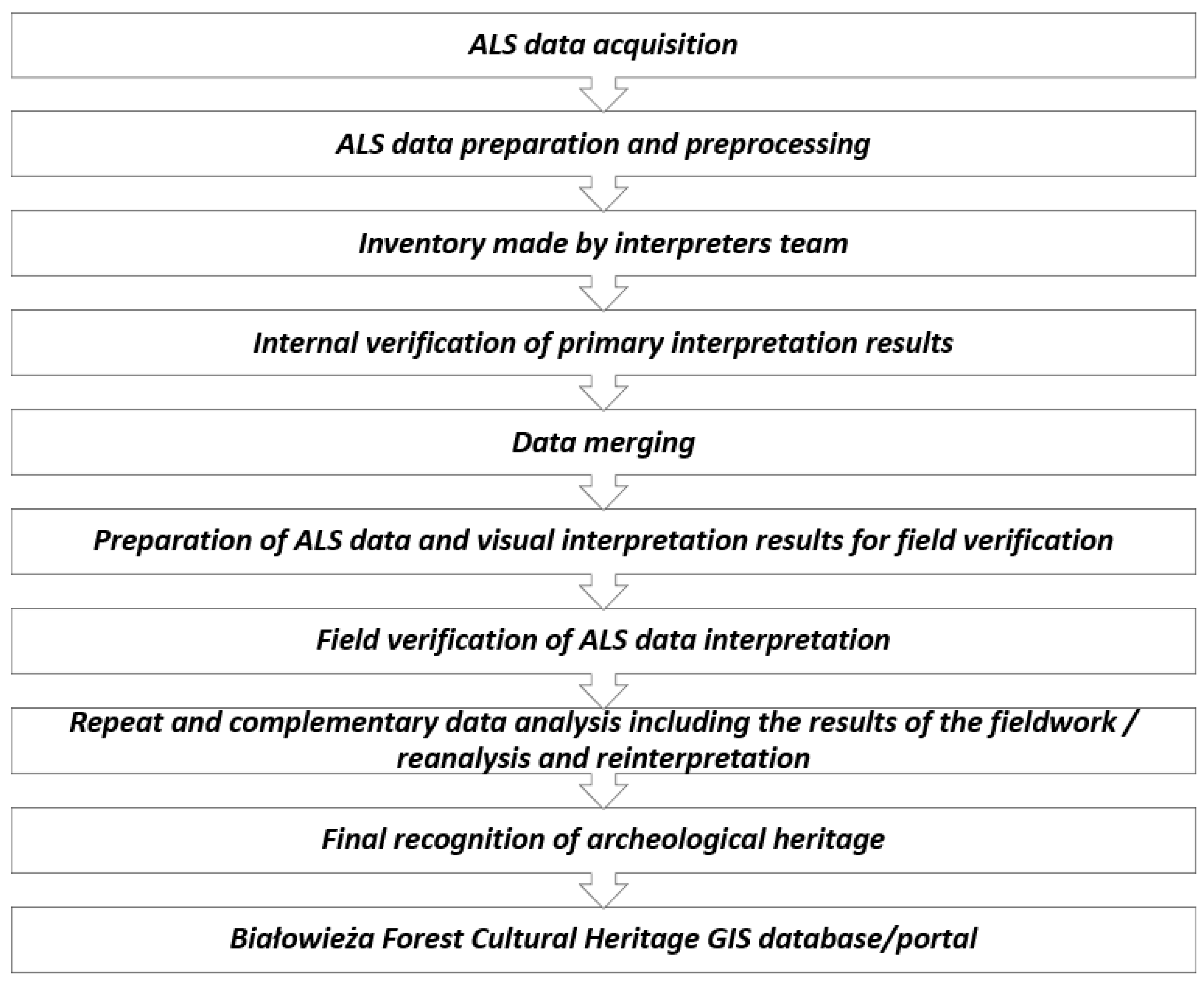
2.2. General Concept
2.3. Archival Data
2.4. ALS Data
- 2—Ground
- 3—Low vegetation
- 4—Average vegetation
- 5—High vegetation
- 6—Buildings and engineering buildings
2.5. DTM Processing
- Slope Exposure Map [38]—a map presenting the azimuth of the ground (stocks) exposition.
- Aspect [41]—a map presenting the orientation of the slope.
- DTM relief hillshade [39] for eight azimuth positions: 0°, 45°, 90°, 135°, 180°, 225°, 270°, 315° and the horizon of 20° (hillshade is a 3D representation of the surface, with the sun’s relative position taken into account for shading the image).
- Local Relief Model [51]—it highlights small-scale surface features by removing large-scale landforms from the DTM.
- Sky-view factor [52]—a map presenting the proportion of the sky visible from a given point, allowing determination of the percentage of terrestrial visibility.
2.6. Primary Analysis and Interpretation
- road network features obtained from the Forest Digital Map;
- watercourse network features obtained from the Forest Digital Map;
- RGB and CIR orthophotos of the area.
2.7. Preparations for Field Verification
- forest compartments and forest district boundaries layers from the Forest Data Bank;
- roads and waterways network layers obtained from the OpenStreetMap service;
- a Digital Terrain Model obtained from the Geodesy and Cartography Documentation Centre in Warsaw;
- historical forest, topographic and soil maps;
- historical aerial images;
- locations and data of archival archaeological sites.
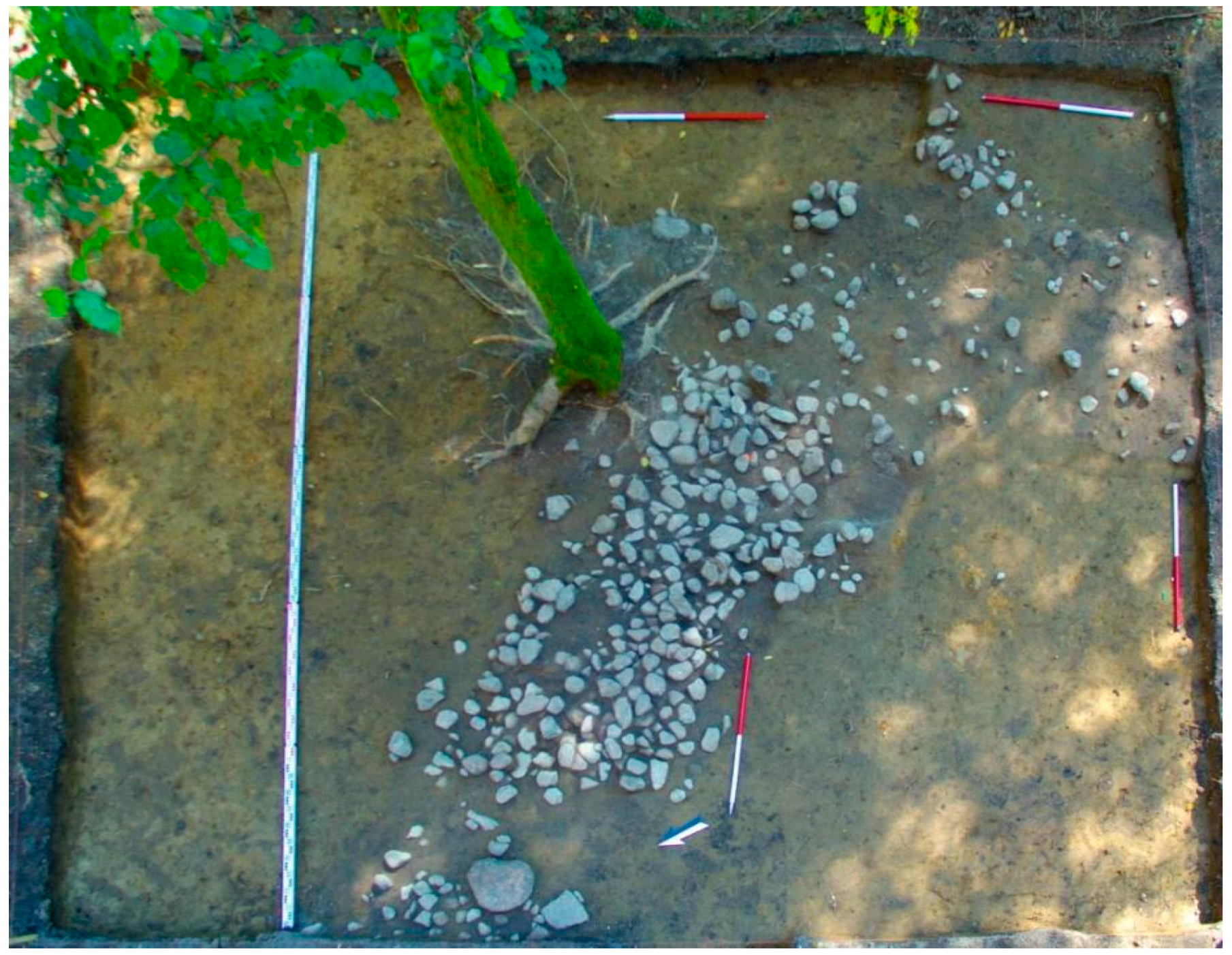
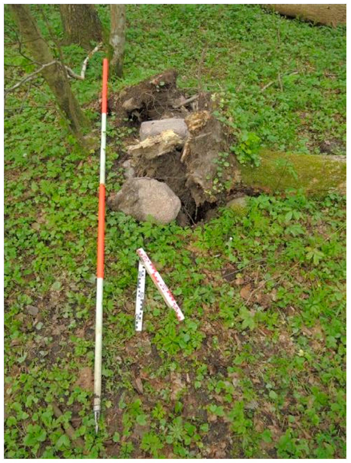
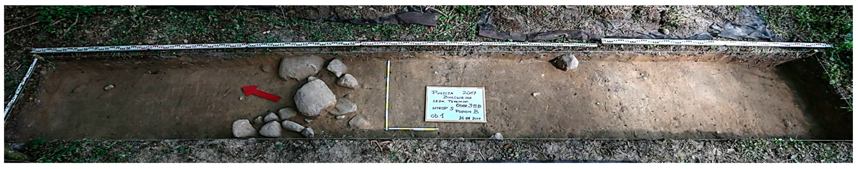
2.8. Systematic and Multi-Site Field Verification and Specialist Analyses
3. Results
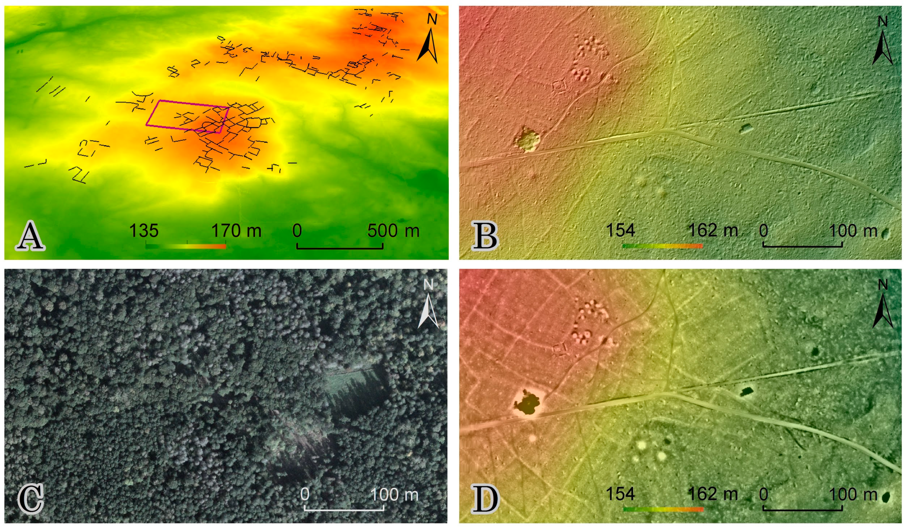
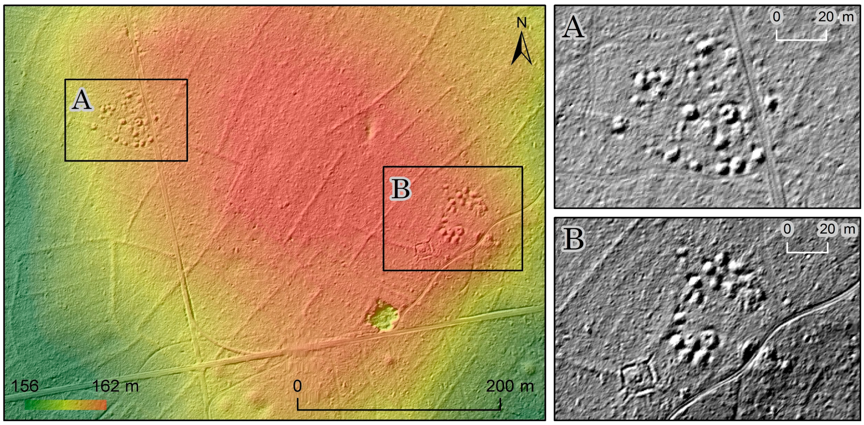
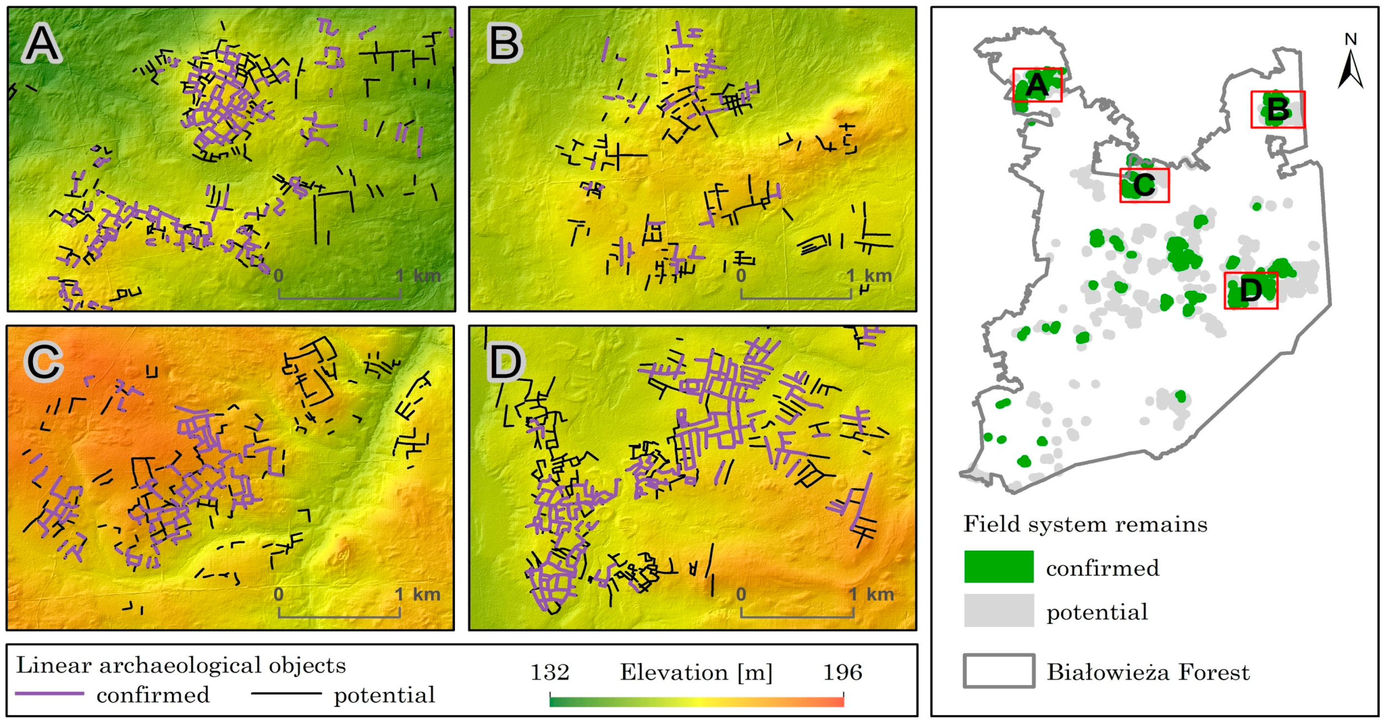
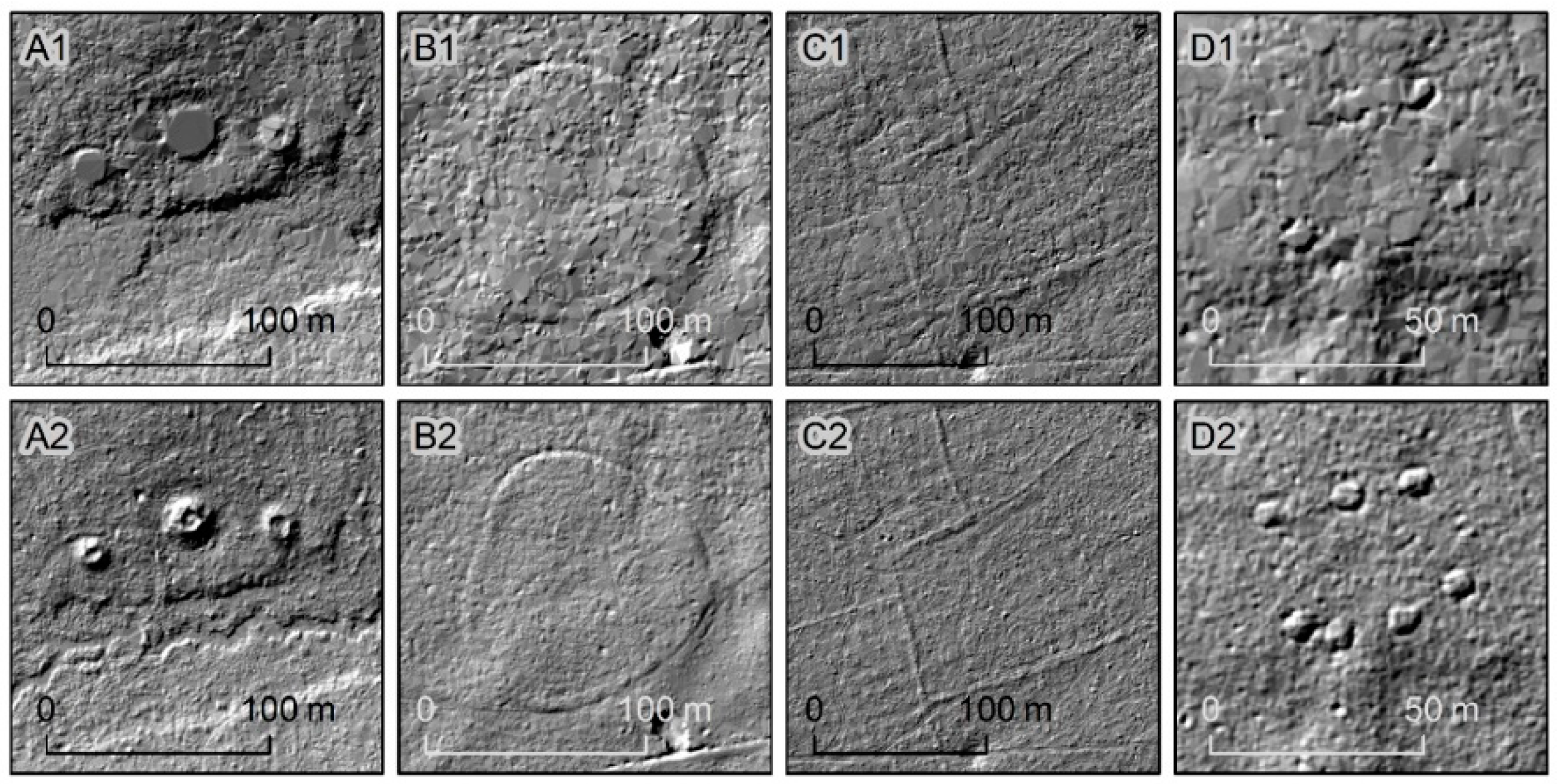
3.1. Primary Recognition
3.2. Fieldwork Verification
- 91 soil test pits;
- 77 archaeological test trenches;
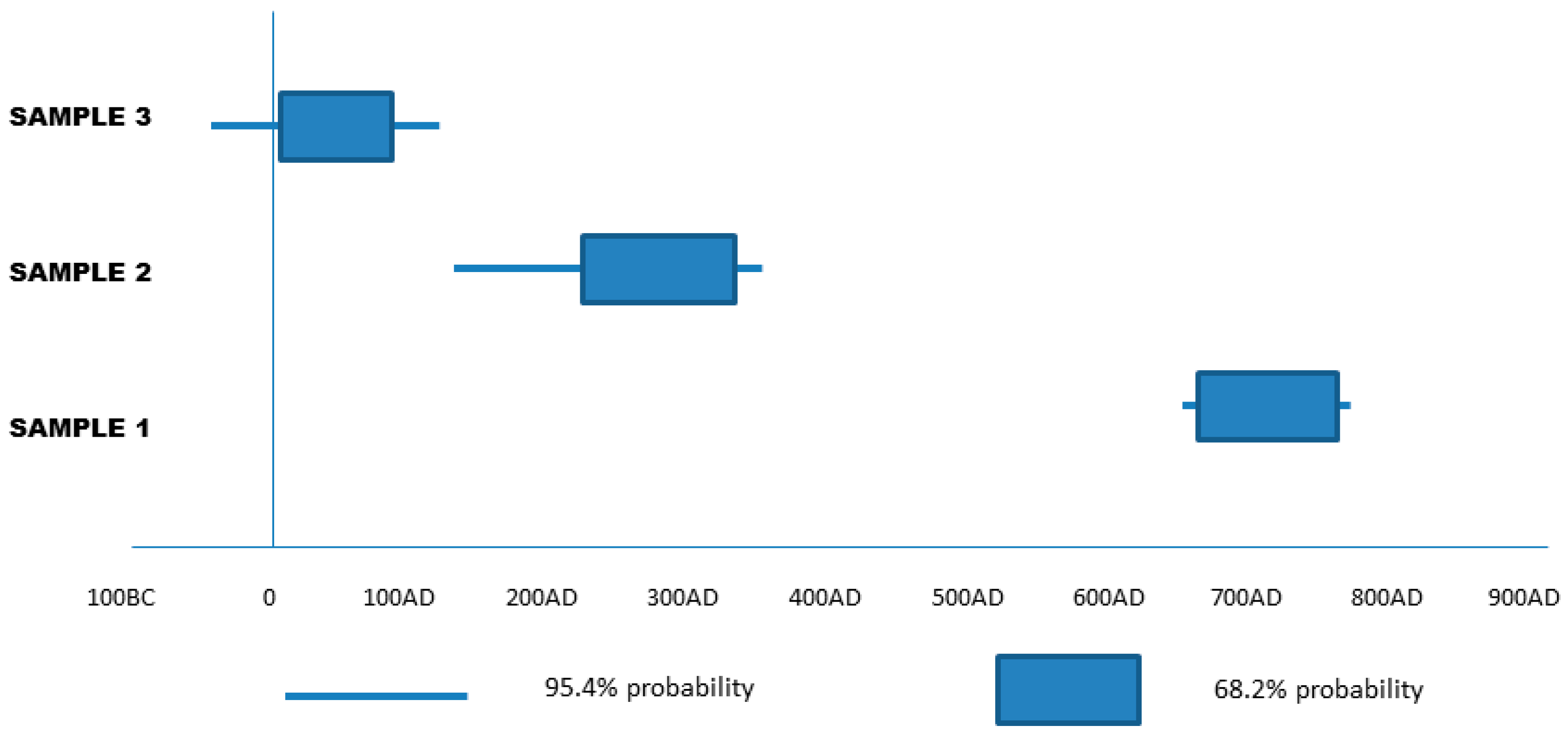
- laboratory analysis.
4. Discussion
5. Conclusions
Author Contributions
Funding
Acknowledgments
Conflicts of Interest
References
- Fiedukowicz, A.; Głażewski, A.; Kołodziej, A.; Koszewski, K.; Kowalski, P.; Olszewski, R.; Włochyński, L. Map portal as a tool to share information on cultural heritage illustrated by the national heritage board geoportal. In Advances in Digital Cultural Heritage; Springer: Funchal, Madeira, Portugal, 2018; pp. 48–64. [Google Scholar]
- Oniszczuk, A.; Makowska, A. Archaeological data in the gis portal of the national heritage board of poland. Internet Archaeol. 2017, 43. [Google Scholar] [CrossRef]
- Bristow, R.S.; Therien, A. Discovering archaeological landscapes in parks and protected areas. N. Am. Archaeol. 2019, 40, 99–115. [Google Scholar] [CrossRef]
- Corns, A.; Shaw, R. Lidar and World Heritage Sites in Ireland: Why was such a rich data source gathered, how is it being utilised, and what lessons have been learned. In Interpreting Archaeological Topography. Airborne Laser Scanning, 3D Data and Ground Observation; Opitz, R.S., Cowley, D.C., Eds.; Oxbow Books: Oxford, UK, 2013; pp. 146–160. [Google Scholar] [CrossRef]
- Opitz, R.S.; Cowley, D.C. Interpreting archaeological topography: Lasers, 3D data, observation, visualisation and applications. In Interpreting Archaeological Topography. Airborne Laser Scanning, 3D Data and Ground Observation; Opitz, R.S., Cowley, D.C., Eds.; Oxbow Books: Oxford, UK, 2013; pp. 1–12. [Google Scholar] [CrossRef]
- Megarry, W.P.; Davenport, B.A.; Comer, D.C. Emerging applications of lidar/airborne laser scanning in the management of world heritage sites. Conserv. Manag. Archaeol. Sites 2016, 18, 393–410. [Google Scholar] [CrossRef]
- Gallagher, J.M.; Josephs, R.L. Using LiDAR to detect cultural resources in a forested environment: An example from Isle Royale National Park, Michigan, USA. Archaeol. Prospect. 2008, 15, 187–206. [Google Scholar] [CrossRef]
- Zimny, M.; Latałowa, M.; Pędziszewska, A. Późnoholoceńska historia lasów rezerwatu ścisłego białowieskiego parku narodowego In Lasy Rezerwatu Ścisłego Białowieskiego Praku Narodowego; Keczyński, A., Ed.; Białowieża National Park: Białowieża, Poland, 2017; pp. 30–59. (In Polish) [Google Scholar]
- Jaroszewicz, B.; Cholewińska, O.; Gutowski, J.M.; Samojlik, T.; Zimny, M.; Latałowa, M. Białowieza forest-a relic of the high naturalness of European forests. Forests 2019, 10, 849. [Google Scholar] [CrossRef]
- Mitchell, F.J.G.; Cole, E. Reconstruction of long-term successional dynamics of temperate woodland in Bialowieza Forest, Poland. J. Ecol. 1998, 86, 1042–1059. [Google Scholar] [CrossRef]
- Górska, I. Badania archeologiczne w Puszczy Białowieskiej. [Archaeological investigations in Bialowieza Forest] Archeol. Pol. 1976, 21, 109–134. (In Polish) [Google Scholar]
- Hedemann, O. L’histoire de la foret de Białowiezża jusqu’a 1798 (The history of the forest of Białowiezża before 1798). Inst. Rech. For. Doman. Warszawa Trav. Comptes Rendus Ser. A 1939, 41, 310. [Google Scholar]
- Franklin, S. Białowieża forest, Poland: Representation, myth, and the politics of dispossession. Environ. Plan. A 2002, 34, 1459–1485. [Google Scholar] [CrossRef]
- Niklasson, M.; Zin, E.; Zielonka, T.; Feijen, M.; Korczyk, A.F.; Churski, M.; Samojlik, T.; Jędędrzejewska, B.; Gutowski, J.M.; Brzeziecki, B. A 350-year tree-ring fire record from Białowieza primeval forest, Poland: Implications for central European lowland fire history. J. Ecol. 2010, 98, 1319–1329. [Google Scholar] [CrossRef]
- Sunseri, T. Exploiting the Urwald: German post-colonial forestry in Poland and central Africa, 1900–1960. Past Present 2012, 214, 305–342. [Google Scholar] [CrossRef]
- Więcko, E. Puszcza Białowieska; Państwowe Wydawnictwo Naukowe: Warsaw, Poland, 1972; p. 193. (In Polish) [Google Scholar]
- Kuijper, D.P.J.; Jędrzejewska, B.; Brzeziecki, B.; Churski, M.; Jędrzejewski, W.; Żybura, H. Fluctuating ungulate density shapes tree recruitment in natural stands of the Białowieża Primeval Forest, Poland. J. Veg. Sci. 2010, 21, 1082–1098. [Google Scholar] [CrossRef]
- Goetze, A. Archäologische Untersuchungen im Urwalde von Bialowies; Verl. der Bayer. Akad. der Wiss: Muünchen, Germany, 1929; Available online: http://www.worldcat.org/title/archaologische-untersuchungen-im-urwalde-von-bialowies/oclc/313608484 (accessed on 14 June 2020). (In German)
- Krasnodębski, D.; Olczak, H. Badania archeologiczne na terenie polskiej części Puszczy Białowieskiej–stan obecny, problemy i perspektywy. Biul. Konserw. Województwa Podl. 2012, 18, 145–168. (In Polish) [Google Scholar]
- Więcko, E. Puszcza Białowieska; Państwowe Wydawnictwo Naukowe: Warszawa, Poland, 1984; pp. 1–309. (In Polish) [Google Scholar]
- Samojlik, T. Traditional utilisation of Białowieża Primeval Forest (Poland) in the 15th to 18th centuries. Landsc. Archaeol. Ecol. 2010, 8, 150–164. [Google Scholar]
- Samojlik, T.; Fedotova, A.; Kuijper, D.P.J. Transition from traditional to modern forest management shaped the spatial extent of cattle pasturing in Białowieża Primeval Forest in the nineteenth and twentieth centuries. Ambio 2016, 45, 904–918. [Google Scholar] [CrossRef]
- Krasnodębski, D.; Olczak, H.; Samojlik, T. Wczesnośredniowieczne Cmentarzyska w Puszczy Białowieskiej. In Silvis, Campis et Urbe; Kotowicz, W.P., Ed.; Rzeszów: Sanok, Poland, 2010; pp. 145–174. (In Polish) [Google Scholar]
- Samojlik, T.; Jȩdrzejewska, B.; Michniewicz, M.; Krasnodȩbski, D.; Dulinicz, M.; Olczak, H.; Karczewski, A.; Rotherham, I.D. Tree species used for low-intensity production of charcoal and wood-tar in the 18th-century Białowieza Primeval Forest. Pol. Phytocoenol. 2013, 43, 1–12. [Google Scholar] [CrossRef]
- Pabian, O.; Jaroszewicz, B. Assessing Socio-Economic Benefits of Natura 2000—A Case Study on the Ecosystem Service Provided by Białowieża Forest. Output of the Project Financing Natura 2000: Cost Estimate and Benefits of Natura 2000 (Contract No.: 070307/2007/484403/MAR/B2); Institute for European Environmental Policy: Brussels, Belgium, 2009; 69p. [Google Scholar]
- Bewley, R.H.; Crutchley, S.P.; Shell, C.A. New light on an ancient landscape: Lidar survey in the Stonehenge World Heritage Site. Antiquity 2005, 79, 636–647. [Google Scholar] [CrossRef]
- Devereux, B.J.; Amable, G.S.; Crow, P.; Cliff, A.D. The potential of airborne lidar for detection of archaeological features under woodland canopies. Antiquity 2005, 79, 648–660. [Google Scholar] [CrossRef]
- Doneus, M.; Briese, C.; Fera, M.; Janner, M. Archaeological prospection of forested areas using full-waveform airborne laser scanning. J. Archaeol. Sci. 2008, 35, 882–893. [Google Scholar] [CrossRef]
- Crutchley, S. Using LiDAR in archaeological contexts: The English heritage experience and lessons learned. Laser Scanning Environ. Sci. 2009, 180–200. [Google Scholar] [CrossRef]
- Masini, N.; Coluzzi, R.; Lasaponara, R. On the airborne Lidar contribution in archaeology: From site identification to landscape investigation. In Laser Scanning, Theory and Applications; Wang, C.-C., Ed.; Intech: London, UK, 2011; pp. 263–290. ISBN 978-953-307-205-0. [Google Scholar]
- Zapłata, R. Nieinwazyjne Metody w Badaniu i Dokumentacji Dziedzictwa Kulturowego—Aspekty Skanowania Laserowego w Badaniach Archeologicznych i Architektonicznych; Fundacja Hereditas: Warszawa, Poland, 2013; Available online: https://fundacja-hereditas.pl/publikacje/nieinwazyjne-metody-w-badaniu-i-dokumentacji-dziedzictwa-kulturowego-aspekty-skanowania-laserowego-w-badaniach-archeologicznych-i-architektonicznych/ (accessed on 1 June 2020). (In Polish)
- Banaszek, Ł. Przeszłe Krajobrazy w Chmurze Punktów; Wydawnictwo Naukowe UAM: Poznań, Poland, 2015. (In Polish) [Google Scholar]
- Gojda, M.; Kobyliński, Z. (Eds.) Lotnicze Skanowanie Laserowe jako Narzędzie Archeologii; Fundacja Res Publica Multiethnica: Warsaw, Poland, 2018; Available online: https://archaeologica-hereditas.org/2020/03/08/tom-11-volume-11/ (accessed on 1 June 2020). (In Polish)
- Masini, N.; Gizzi, F.T.; Biscione, M.; Fundone, V.; Sedile, M.; Sileo, M.; Pecci, A.; Lacovara, B.; Lasaponara, R. Medieval archaeology under the canopy with LiDAR. The (re) discovery of a medieval fortified settlement in Southern Italy. Remote Sens. 2018, 10, 1598. [Google Scholar] [CrossRef]
- Luo, L.; Wang, X.; Guo, H.; Lasaponara, R.; Zong, Z.; Masini, N.; Wang, G.; Shi, P.; Khatteli, H.; Chen, F. Airborne and spaceborne remote sensing for archaeological and cultural heritage applications: A review of the century (1907–2017). Remote Sens. Environ. 2019, 232, 111280. [Google Scholar] [CrossRef]
- Maślanka, M.; Wężyk, P. Podręcznik Dla Uczestników Szkoleń Z Wykorzystania Produktów LiDAR; Główny Urząd Geodezji i Kartografii: Warszawa, Poland, 2014. Available online: http://www.gugik.gov.pl/__data/assets/pdf_file/0019/23752/PODRECZNIK_ISOK_wyd.2.pdf (accessed on 1 June 2020). (In Polish)
- Kurczyński, Z. Airborne Laser scanning in poland-between science and practice. Arch. Photogramm. Cartogr. Remote Sens. 2019, 31, 105–133. [Google Scholar]
- Chase, A.; Chase, D.; Fisher, C.; Leisz, S.; Weishampel, J. Geospatial revolution and remote sensing LiDAR in Mesoamerican archaeology. Proc. Natl. Acad. Sci. USA 2012, 109, 12916–12921. [Google Scholar] [CrossRef]
- Johnson, K.M.; Ouimet, W.B. Rediscovering the lost archaeological landscape of southern New England using airborne light detection and ranging (LiDAR). J. Archaeol. Sci. 2014, 43, 9–20. [Google Scholar] [CrossRef]
- Chase, A.; Chase, D.; Weishampel, J. Lasers in the Jungle Airborne sensors reveal a vast Maya landscape. Archaeology 2010, 63, 27–29. [Google Scholar]
- Stereńczak, K.; Ciesielski, M.; Bałazy, R.; Zawiła-Niedźwiecki, T. Comparison of various algorithms for DTM interpolation from LIDAR data in dense mountain forests. Eur. J. Remote Sens. 2016, 49, 599–621. [Google Scholar] [CrossRef]
- Zakšek, K.; Oštir, K.; Kokalj, Ž. Sky-view factor as a relief visualization technique. Remote Sens. 2011, 3, 398–415. [Google Scholar] [CrossRef]
- Chase, A.F.; Chase, D.Z.; Weishampel, J.F.; Drake, J.B.; Shrestha, R.L.; Slatton, K.C.; Awe, J.J.; Carter, W.E. Airborne LiDAR, archaeology, and the ancient Maya landscape at Caracol, Belize. J. Archaeol. Sci. 2011, 38, 387–398. [Google Scholar] [CrossRef]
- Challis, K.; Forlin, P.; Kincey, M. A generic toolkit for the visualization of archaeological features on airborne LiDAR elevation data. Archaeol. Prospect. 2011, 18, 279–289. [Google Scholar] [CrossRef]
- Johnson, K.M.; Ouimet, W.B. An observational and theoretical framework for interpreting the landscape palimpsest through airborne LiDAR. Appl. Geogr. 2018, 91, 32–44. [Google Scholar] [CrossRef]
- Crutchley, S. Light detection and ranging (lidar) in the Witham Valley, Lincolnshire: An assessment of new remote sensing techniques. Archaeol. Prospect. 2006, 13, 251–257. [Google Scholar] [CrossRef]
- Falinski, J.D. Vegetation Dynamics in Temperate Lowland Primeval Forests: Ecological Studies in Bialowieza Forest; Springer: Dordrecht, The Netherlands, 1986; p. 537. [Google Scholar] [CrossRef]
- Białowieża Forest. Available online: http://whc.unesco.org/en/list/33 (accessed on 17 September 2017).
- LAS Specification Version 1.2. Available online: https://www.asprs.org/wp-content/uploads/2010/12/asprs_las_format_v12.pdf (accessed on 17 August 2020).
- Bennett, R.; Welham, K.; Hill Ra Ford, A. A comparison of visualization techniques for models created from airborne laser scanned data. Archaeol. Prospect. 2012, 19, 41–48. [Google Scholar] [CrossRef]
- Hesse, R. LiDAR-derived local relief models—A new tool for archaeological prospection. Archaeol. Prospect. 2010, 17, 67–72. [Google Scholar] [CrossRef]
- Kokalj, Ž.; Zakšek, K.; Oštir, K. Application of sky-view factor for the visualisation of historic landscape features in lidar-derived relief models. Antiquity 2011, 85, 263–273. [Google Scholar] [CrossRef]
- Crawford, O.G.S. Air survey and archaeology. Geogr. J. 1923, 61, 342–360. [Google Scholar] [CrossRef]
- Curwen, E.; Curwen, E.C. Sussex lynchets and their associated fieldways. Sussex Archaeol. Collect. 1923, 64, 1–65. [Google Scholar]
- Field Systems. Introduction to Heritage Assets. Historic England. 2018. Available online: https://historicengland.org.uk/images-books/publications/iha-field-systems/heag204-field-systems/ (accessed on 1 June 2020).
- Nielsen, N.; Holst, M.; Gadd, A.; Holst, K. The layout and internal development of celtic fields: structural and relative chronological analyses of three danish field systems. Eur. J. Archaeol. 2018, 21, 385–410. [Google Scholar] [CrossRef]
- Wawrzeniuk, J.; Budziszewski, J.; Jakubczak, M.; Rutyna, M.; Szlązak, R.; Szubski, M.; Urbańczyk, P. Dziedzictwo kulturowe puszczy białowieskiej–wstępne rozpoznanie, in dziedzictwo kulturowe w lasach. In Dziedzictwo kulturowe w lasach; Wysocki, J., Ed.; Fundacja Archeologiczna: Warszawa-Zielona Góra, Poland, 2017; pp. 193–200. (In Polish) [Google Scholar]
- Humme, A.; Lindenbergh, R.; Sueur, C. Revealing celtic fields from lidar data using kriging based filtering. In Proceedings of the ISPRS Commission V Symposium, Dresden, Germany, 26–27 September 2006; Available online: https://www.isprs.org/proceedings/xxxvi/part5/paper/1241_dresden06.pdf (accessed on 1 June 2020).
- Mayoral, A.; Toumazet, J.P.; Simon, F.X.; Vautier, F.; Peiry, J.L. The highest gradient model: A new method for analytical assessment of the efficiency of lidar-derived visualization techniques for landform detection and mapping. Remote Sens. 2017, 9, 120. Available online: https://www.mdpi.com/2072-4292/9/2/120/pdf (accessed on 1 June 2020). [CrossRef]
- Arnoldussen, S. The fields that outlived the celts: The use-histories of later prehistoric field systems (celtic fields or raatakkers) in the Netherlands. In Proceedings of the Prehistoric Society; Cambridge University Press: Cambridge, UK, 2018; Volume 84, pp. 303–327. [Google Scholar]
- Meylemans, E.; De Bie, M. Revealing extensive protohistoric field systems through high resolution lidar data in the northern part of Belgium. Archäologisches Korresp. 2015, 45, 197–213. Available online: https://www.researchgate.net/publication/280551305_Revealing_Extensive_Protohistoric_Field_Systems_through_High_Resolution_LIDAR_Data_in_the_Northern_Part_of_Belgium (accessed on 1 June 2020).
- Solecki, R. Wykorzystanie lotniczego skanowania laserowego (ALS) w prospekcji dawnych dól uprawnych na przykładzie reliktów z Miłomłyna w powiecie ostródzkim. In Lotnicze Skanowanie Laserowe Jako Narzędzie Archeologii; Gojda, M., Kobyliński, Z., Eds.; Fundacja Res Publica Multiethnica: Warszawa, Poland, 2018; pp. 233–241. Available online: https://archaeologica-hereditas.org/2020/03/08/tom-11-volume-11/ (accessed on 1 June 2020). (In Polish)
- Dobiegała, M.; Jakubczak, M. Pozostałości Pól Typu Celtic Fields z Miejscowości Michałów-Regiów, Pow. Legionowski, W Świetle Obrazowań Lotniczego Skanowania Laserowego. In Lotnicze Skanowanie Laserowe Jako Narzędzie Archeologii; Gojda, M., Kobyliński, Z., Eds.; Fundacja Res Publica Multiethnica: Warszawa, Poland, 2018; pp. 243–249. Available online: https://archaeologica-hereditas.org/2020/03/08/tom-11-volume-11/ (accessed on 1 June 2020).
- Stereńczak, K.; Krasnodębski, D.; Zapłata, R.; Kraszewski, B.; Mielcarek, M. Sprawozdanie z Realizacji Zadania Inwentaryzacja Dziedzictwa Kulturowego, w Projekcie pt. Ocena Stanu Różnorodności Biologicznej w Puszczy Białowieskiej na Podstawie Wybranych Elementów Przyrodniczych i Kulturowych; Forest Research Institute: Sękocin Stary, Poland, 2016. (In Polish) [Google Scholar]
- Zapłata, R.; Stereńczak, K. Puszcza Białowieska, LiDAR i dziedzictwo kulturowe–zagadnienia wprowadzające. Raport 2016, 11, 239–255. Available online: https://www.nid.pl/upload/iblock/2e9/2e968b90a5e3db3038e08f1c4d5be905.pdf (accessed on 1 June 2020). (In Polish).
- Zapłata, R.; Stereńczak, K.; Grześkowiak, M.; Wilk, A.; Obidziński, A.; Zawadzki, M.; Stępnik, J.; Kwiatkowska, E.; Kuciewicz, E. Raport Końcowy. Zadanie “Inwentaryzacja Dziedzictwa Kulturowego” na Terenie Polskiej części Puszczy Białowieskiej w Ramach Projektu “Ocena i Monitoring Zmian Stanu Różnorodności Biologicznej W Puszczy Białowieskiej Na Podstawie Wybranych Elementów Przyrodniczych I Kulturowych–Kontynuacja”; Forest Research Institute: Sękocin Stary, Poland, 2019. (In Polish) [Google Scholar]
- Assessment of the Condition of Biodiversity in the Bialowieza Forest Based on Selected Natural and Cultural Elements” and “Assessment of the Condition of Biodiversity in the Bialowieza Forest Based on Selected Natural and Cultural Elements–Continuation”. (“Ocena Stanu Różnorodności Biologicznej w Puszczy Białowieskiej na Podstawie Wybranych Elementów Przyrodniczych i Kulturowych” and “Ocena Stanu Różnorodności Biologicznej w Puszczy Białowieskiej na Podstawie Wybranych Elementów Przyrodniczych i Kulturowych–Kontynuacja”); Forest Research Institute: Sękocin Stary, Poland, 2016. (In Polish)
- Zapłata, R.; Wilk, A.; Grześkowiak, M.; Obidziński, A.; Zawadzki, M.; Stereńczak, K.; Kuberski, Ł. “Dziedzictwo Kulturowe I Rys Historyczny Polskiej Części Puszczy Białowieskiej”, Której Przedmiotem Była “Analiza Wybranych Zasobów Archiwalnych Oraz Wyników Badań Archeologicznych Na Terenie Polskiej Części Puszczy Białowieskiej”; Sprawozdanie końcowe w związku z realizacją umowy nr EO.271.3.5.2019 z dnia 29 marca 2019 r.; Forest Research Institute: Sękocin Stary, Poland, 2019. (In Polish) [Google Scholar]
- Ksepko, M.; Porowski, J.; Szubzda, S.; Kolendo, Ł. Raport z Badań Gleboznawczych W Ramach Studiów Archeologicznych W Puszczy Białowieskiej—Sezon 2017; Bureau for Forest Management and Geodesy: Białystok, Poland, 2018. (In Polish) [Google Scholar]
- Goslar, T. Raport z Wykonania Datowań C-14 w Poznańskim Laboratorium Radiowęglowym; Poznan Radiocarbon Laboratory: Poznań, Poland, 2018. (In Polish) [Google Scholar]
- Krąpiec, M. Zestawienie Wyników Datowań Radiowęglowych Techniką LSC; Laboratorium Datowań Bezwzględnych: Cianowice, Poland, 2019. (In Polish) [Google Scholar]
- Van Giffen, A.E. Prehistoric fields in Holland. Antiquity 1928, 2, 85–87. [Google Scholar]
- Spek, T.; Waateringe, W.; Kooistra, M.J.; Bakker, L. Formation and land-use history of celtic fields in north-west Europe–an interdisciplinary case study at Zeijen, the Netherlands. Eur. J. Archaeol. 2003, 6, 141–173. [Google Scholar] [CrossRef]
- Hesse, R. Detecting Former Field Systems with Airborne LIDAR—An Overview of Current Methods; [poster]; 2012. Available online: https://www.academia.edu/1941481/Detecting_former_field_systems_with_airborne_LIDAR_an_overview_of_current_methods (accessed on 1 June 2020).
- Arnoldussen, S.; van der Linden, M. Palaeo-ecological and archaeological analysis of two Dutch Celtic fields (Zeijen-Noordse Veld and Wekerom-Lunteren): Solving the puzzle of local Celtic field bank formation. Veg. Hist. Archaeobot. 2017, 26, 551–570. [Google Scholar] [CrossRef]
- Kooistra, M.J.; Maas, G.J. The widespread occurrence of Celtic field systems in the central part of the Netherlands. J. Archaeol. Sci. 2008, 35, 2318–2328. [Google Scholar] [CrossRef]
- Nielsen, N.H.; Dalsgaard, K. Dynamics of Celtic fields—A geoarchaeological investigation of Øster Lem Hede, Western Jutland, Denmark. Geoarchaeology 2017, 32, 414–434. [Google Scholar] [CrossRef]
- Campana, S. Drones in archaeology. State-of-the-art and future perspectives. Archaeol. Prospect. 2017, 24, 275–296. [Google Scholar] [CrossRef]
- Zapłata, R. Koncepcja wsparcia nieinwazyjnego badania zabytków na terenach leśnych w Polsce—System typu Personal Laser Scanning. In Cyfryzacja Naukach Przeszłości Ochr. Zabyt.—Digit. Nieinwazyjne Bad. Dziedzictwa Kult. Situ; Zapłata, R., Ed.; Cardinal Stefan Wyszynski University: Warsaw, Poland, 2015; pp. 57–79. (In Polish) [Google Scholar]
- Trier, Ø.; Pilø, L.H. Archaeological mapping of large forested areas, using semi-automatic detection and visual interpretation of high-resolution Lidar data. In Proceedings of the CAA-2014, Paris, France, 26 April 2014; pp. 3–25. [Google Scholar]
- Trier, Ø.D.; Pilø, L.H.; Johansen, H.M. Semi-automatic mapping of cultural heritage from airborne laser scanning data. Sémata Cienc. Sociais e Hum. 2015, 27, 159–186. [Google Scholar]
- Trier, Ø.D.; Cowley, D.C.; Waldeland, A.U. Using deep neural networks on airborne laser scanning data: Results from a case study of semi-automatic mapping of archaeological topography on Arran, Scotland. Archaeol. Prospect. 2019, 26, 165–175. [Google Scholar] [CrossRef]
- Guyot, A.; Hubert-Moy, L.; Lorho, T. Detecting neolithic burial mounds from lidar-derived elevation data using a multi-scale approach and machine learning techniques. Remote Sens. 2018, 10, 225. [Google Scholar] [CrossRef]
- Bakuła, K.; Ostrowski, W.; Zapłata, R. Automatyzacja w procesie detekcji obiektów archeologicznych z danych ALS. In Folia Praaehistorica Posnaniensia, XIX; Uniwersytet im. Adama Mickiewicza: Poznań, Poland, 2014; pp. 189–206. (In Polish) [Google Scholar]
- Stereńczak, K.; Zapłata, R. Archaeological Heritage in Forested Areas—Challenges, Problems and Solutions. Raport 2018, 13, 117–128. Available online: https://www.nid.pl/upload/iblock/dcc/dcc2b53f1d0ec080d36b471ab2823cb2.pdf (accessed on 1 June 2020).
- Zapłata, R.; Stereńczak, K.; Kraszewski, B. Wielkoobszarowe badania dziedzictwa archeologicznego na terenach leśnych. Kurier Konserwatorski 2018, 15, 47–51. [Google Scholar]
- Zapłata, R.; Stereńczak, K. Badania Archeologiczne na Obszarach Leśnych—Aktualne Wyzwania i Możliwości w Dobie Technologii Geoinformacyjnych. In Zastosowanie Geoinformatyki w Leśnictwie; Stereńczak, K., Ed.; Forest Research Institute: Sękocin Stary, Poland, 2020; pp. 383–402. (In Polish) [Google Scholar]
- Meylemans, S. The fields that outlived the Celts: The use-histories of later prehistoric field systems (Celtic Fields or Raatakkers) in The Netherlands. In Proceedings of the Prehistoric Society; Cambridge University Press: Cambridge, UK, 2018; Volume 84, pp. 303–327. [Google Scholar]
- Opitz, R.S.; Cowley, D.C. Interpreting Archaeological Topography. Airborne Laser Scanning, 3D Data and Ground Observation; Oxbow Books: Oxford, UK, 2013. [Google Scholar]
- Bush, M.B.; McMichael, C.H.; Piperno, D.R.; Silman, M.R.; Barlow, J.; Peres, C.A.; Power, M.; Palace, M.W. Anthropogenic influence on Amazonian forests in pre-history: An ecological perspective. J. Biogeogr. 2015, 42, 2277–2288. [Google Scholar] [CrossRef]
- Bush, M.B.; Correa-Metrio, A.; McMichael, C.H.; Sully, S.; Shadik, C.R.; Valencia, B.G.; Guilderson, T.; Steinitz-Kannan, M.; Overpeck, J.T. A 6900-year history of landscape modification by humans in lowland Amazonia. Quat. Sci. Rev. 2016, 141, 52–64. [Google Scholar] [CrossRef]
- Fisher, C.T.; Fernández-Diaz, J.C.; Cohen, A.S.; Neil Cruz, O.; Gonzáles, A.M.; Leisz, S.J.; Pezzutti, F.; Shrestha, R.; Carter, W. Identifying ancient settlement patterns through lidar in the mosquitia region of honduras. PLoS ONE 2016, 11, e0159890. [Google Scholar] [CrossRef]
- Canuto, M.A.; Estrada-Belli, F.; Garrison, T.G.; Houston, S.D.; Acuña, M.J.; Kováč, M.; Marken, D.; Nondédéo, P.; Auld-Thomas, L.; Castanet, C.; et al. Ancient lowland maya complexity as revealed by airborne laser scanning of northern Guatemala. Science 2018, 80, 361. [Google Scholar] [CrossRef]
- Beach, T.; Luzzadder-Beach, S.; Krause, S.; Guderjan, T.; Valdez, F., Jr.; Fernandez-Diaz, J.C.; Eshleman, S.; Doyle, C. Ancient Maya wetland fields revealed under tropical forest canopy from laser scanning and multiproxy evidence. Proc. Natl. Acad. Sci. USA 2019, 116, 21469–21477. [Google Scholar] [CrossRef]
- Barbour, T.E.; Sassaman, K.E.; Almeyda Zambrano, A.M.; North Broadbent, E.; Wilkinson Kanaski, B.R. Rare pre-Columbian settlement on the Florida Gulf Coast revealed through high-resolution drone LiDAR. Proc. Natl. Acad. Sci. USA 2019, 116, 23493–23498. [Google Scholar] [CrossRef]
- Blicharska, M.; Angelstam, P.; Giessen, L.; Hilszczański, J.; Hermanowicz, E.; Holeksa, J.; Jacobsen, J.B.; Jaroszewicz, B.; Konczal, A.; Konieczny, A.; et al. Between biodiversity conservation and sustainable forest management–A multidisciplinary assessment of the emblematic Białowieża Forest case. Biol. Conserv. 2020, 248, 108614. [Google Scholar] [CrossRef]


| Administrative Unit | Point Objects * | Linear Objects ** |
|---|---|---|
| Białowieża Forest District | 3519 | 980 |
| Browsk Forest District | 7572 | 1449 |
| Hajnówka Forest District | 6761 | 521 |
| Białowieża National Park | 2811 | 890 |
| TOTAL | 20,663 | 3840 |
| Description | Summary |
|---|---|
| Total number of linear ridges recognized in the ALS data in 2016. | 3840 |
| Total (estimated) length of recognized linear ridges—potential remains of former fields | 300 km |
| Number of selected linear elevations for field verification (single linear ridges) | 1328 |
| Positively verified (surface field verifications) of linear elevations in the field (single linear ridges) | 1232 |
| Total—approximate area of the land on which linear ridges were identified on the basis of the ALS database, together with areas within the linear ridges (potential fields, pastures, etc.) | 2500 ha |
© 2020 by the authors. Licensee MDPI, Basel, Switzerland. This article is an open access article distributed under the terms and conditions of the Creative Commons Attribution (CC BY) license (http://creativecommons.org/licenses/by/4.0/).
Share and Cite
Stereńczak, K.; Zapłata, R.; Wójcik, J.; Kraszewski, B.; Mielcarek, M.; Mitelsztedt, K.; Białczak, M.; Krok, G.; Kuberski, Ł.; Markiewicz, A.; et al. ALS-Based Detection of Past Human Activities in the Białowieża Forest—New Evidence of Unknown Remains of Past Agricultural Systems. Remote Sens. 2020, 12, 2657. https://doi.org/10.3390/rs12162657
Stereńczak K, Zapłata R, Wójcik J, Kraszewski B, Mielcarek M, Mitelsztedt K, Białczak M, Krok G, Kuberski Ł, Markiewicz A, et al. ALS-Based Detection of Past Human Activities in the Białowieża Forest—New Evidence of Unknown Remains of Past Agricultural Systems. Remote Sensing. 2020; 12(16):2657. https://doi.org/10.3390/rs12162657
Chicago/Turabian StyleStereńczak, Krzysztof, Rafał Zapłata, Jarosław Wójcik, Bartłomiej Kraszewski, Miłosz Mielcarek, Krzysztof Mitelsztedt, Małgorzata Białczak, Grzegorz Krok, Łukasz Kuberski, Anna Markiewicz, and et al. 2020. "ALS-Based Detection of Past Human Activities in the Białowieża Forest—New Evidence of Unknown Remains of Past Agricultural Systems" Remote Sensing 12, no. 16: 2657. https://doi.org/10.3390/rs12162657
APA StyleStereńczak, K., Zapłata, R., Wójcik, J., Kraszewski, B., Mielcarek, M., Mitelsztedt, K., Białczak, M., Krok, G., Kuberski, Ł., Markiewicz, A., Modzelewska, A., Parkitna, K., Piasecka, Ż., Pilch, K., Rzeczycki, K., Sadkowski, R., Wietecha, M., Rysiak, P., von Gadow, K., & Cieszewski, C. J. (2020). ALS-Based Detection of Past Human Activities in the Białowieża Forest—New Evidence of Unknown Remains of Past Agricultural Systems. Remote Sensing, 12(16), 2657. https://doi.org/10.3390/rs12162657