Scientific Challenges and Present Capabilities in Underwater Robotic Vehicle Design and Navigation for Oceanographic Exploration Under-Ice

 , , , , , , , and
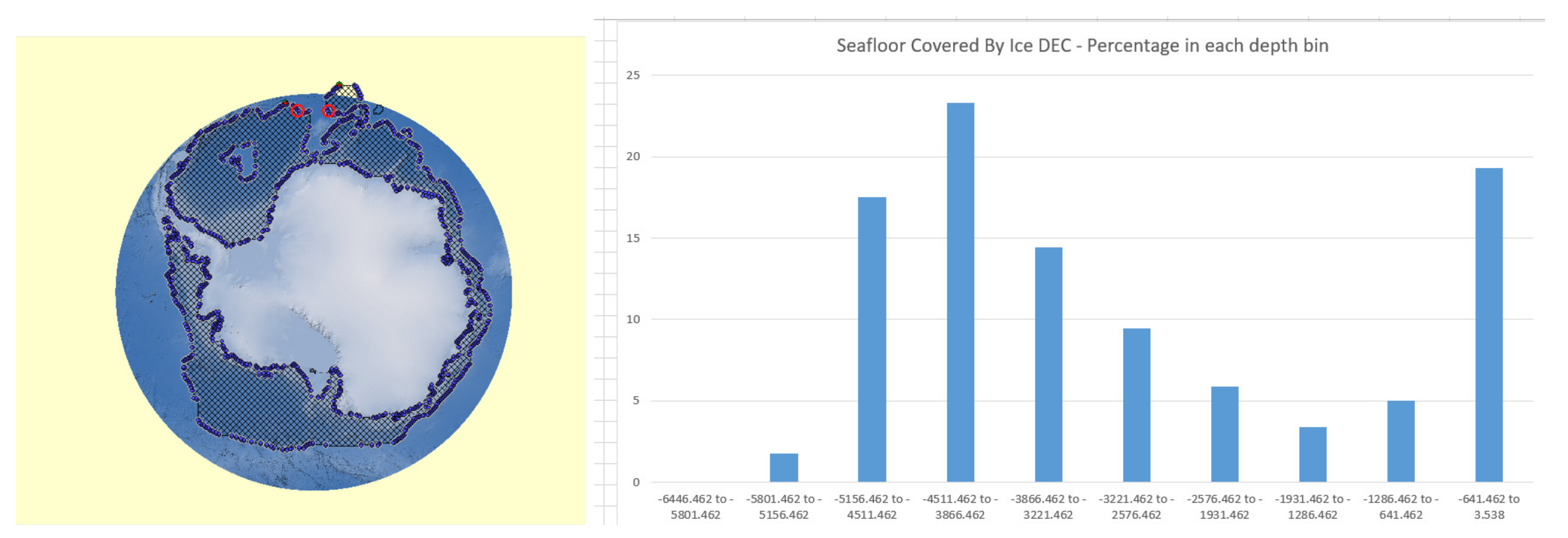
Abstract
1. Introduction
2. Scientific Motivation and Challenges for Remote Under-Ice Oceanographic Exploration
2.1. Ice Shelves
2.2. Sea Ice and Ocean
2.3. Biology
2.4. Seafloor Mapping
2.5. Geology and Geophysics
2.6. Vehicle Capability Needs for Under-Ice Science Missions
3. Under Ice Navigation
4. Vehicle Design and Navigation under Ice Shelves and Landfast Sea Ice
4.1. Untethered Vehicles
4.2. Tethered Vehicles
4.3. Hybrid Tethered Vehicles
5. Vehicle Design and Navigation under Moving Sea Ice
5.1. Untethered Vehicles
5.2. Tethered Vehicles
5.3. Hybrid Tethered Vehicles
5.4. Underwater Gliders
6. Conclusions
Author Contributions
Funding
Conflicts of Interest
Abbreviations
| ACTV | Autonomous Conductivity Temperature Vehicle |
| AMTV | Autonomous Microconductivity Temperature Vehicle |
| ARCS | Autonomous Remotely Controlled Submersible |
| AUV | Autonomous Underwater Vehicle |
| BRUIE | Buoyant Rover for Under-Ice Exploration |
| CTD | Conductivity Temperature Depth |
| DR | Dead Reckoning |
| DVL | Doppler Velocity Log |
| EKF | Extended Kalman Filter |
| FATTI | Fluorometer and Acoustic Transducer Towable Instrument |
| FOG | Fiber-optic Gyroscope |
| GPS | Global Positioning System |
| HOV | Human Occupied Vehicle |
| HROV | Hybrid Remotely Operated Vehicle |
| IMU | Inertial Measurement Unit |
| INS | Inertial Navigation System |
| ISE | International Submarine Engineering |
| LBL | Long Baseline |
| MBARI | Monterey Bay Aquarium Research Institute |
| MEMS | Micro-electro-mechanical system |
| MIZ | Marginal Ice Zone |
| MSLED | Micro Subglacial Exploration Device |
| NUI | Nereid Under-Ice |
| OWTT | One Way Travel Time |
| PAUL | Polar Autonomous Underwater Laboratory |
| PIG | Pine Island Glacier |
| REMUS | Remote Environmental Monitoring UnitS |
| RF | Radio Frequency |
| RIS | Ross Ice Shelf |
| RLG | Ring-laser Gyroscope |
| ROV | Remotely Operated Vehicle |
| SBL | Short Baseline |
| SCINI | Submersible Capable of under Ice Navigation and Imaging |
| SIR | Sub-Ice ROV |
| SLAM | Simultaneous Localization and Mapping |
| SLW | Subglacial Lake Whillans |
| SODA | Stratified Ocean Dynamics of the Arctic |
| TRN | Terrain Relative Navigation |
| TROV | Telepresence-Controlled Remotely Operated Vehicle |
| TWTT | Two Way Travel Time |
| UARS | Unmanned Arctic Research Submersible System |
| USBL | Ultra-Short Baseline |
| UUV | Uninhabited Underwater Vehicle |
| WHOI | Woods Hole Oceanographic Institution |
| MOR | Mid-Ocean Ridge |
References
- Weeks, W. On Sea Ice; University of Alaska Press: Fairbanks, AK, USA, 2010. [Google Scholar]
- Edmonds, H.N.; Michael, P.J.; Baker, E.T.; Connelly, D.P.; Snow, J.E.; Langmuir, C.H.; Dick, H.J.B.; Mühe, R.; German, C.R.; Graham, D.W. Discovery of abundant hydrothermal venting on the ultra-slow spreading Gakkel Ridge, Arctic Ocean. Nature 2003, 421, 252–256. [Google Scholar] [CrossRef] [PubMed]
- Smethie, W.M.; Chayes, D.; Perry, R.; Schlosser, P. A lightweight vertical rosette for deployment in ice-covered waters. Deep. Sea Res. Part I Oceanogr. Res. Pap. 2011, 58, 460–467. [Google Scholar] [CrossRef]
- Nansen, F. Farthest North: Being the Record of a Voyage of Exploration of the Ship “Fram” 1893–1896 and of a Fifteen Months’ Sleigh Journey by Dr. Nansen and Lieut. Johansen (Complete); Macmillan and Company: London, UK, 1904; Volume 1. [Google Scholar]
- Bourke, R.H.; Garrett, R.P. Sea ice thickness distribution in the Arctic Ocean. Cold Reg. Sci. Technol. 1987, 13, 259–280. [Google Scholar] [CrossRef]
- Jakobsson, M.; Grantz, A.; Kristoffersen, Y.; Macnab, R. Physiographic provinces of the Arctic Ocean seafloor. Geol. Soc. Am. Bull. 2003, 115, 1443–1455. [Google Scholar] [CrossRef]
- Mayer, L.; Jakobsson, M.; Allen, G.; Dorschel, B.; Falconer, R.; Ferrini, V.; Lamarche, G.; Snaith, H.; Weatherall, P. The Nippon Foundation—GEBCO seabed 2030 project: The quest to see the world’s oceans completely mapped by 2030. Geosciences 2018, 8, 63. [Google Scholar] [CrossRef]
- Wulff, U.; Wulff, T. Correcting Navigation Data of shallow-diving AUV in Arctic. Sea Technol. 2015, 56, 27–30. [Google Scholar]
- Wulff, T.; Bauerfeind, E.; von Appen, W.J. Physical and ecological processes at a moving ice edge in the Fram Strait as observed with an AUV. Deep. Sea Res. Part I Oceanogr. Res. Pap. 2016, 115, 253–264. [Google Scholar] [CrossRef]
- Jørgensen, L.; Archambault, P.; Armstrong, C.; Dolgov, A.; Edinger, E.; Gaston, T.; Hildebrand, J.; Piepenburg, D.; Smith, W.; Quillfeldt, C.; et al. Arctic marine biodiversity. In The First Global Integrated Marine Assessment, World Ocean Assessment I; United Nations: New York, NY, USA, 2016; p. 47. [Google Scholar]
- Boetius, A.; Albrecht, S.; Bakker, K.; Bienhold, C.; Felden, J.; Fernández-Méndez, M.; Hendricks, S.; Katlein, C.; Lalande, C.; Krumpen, T.; et al. RV Polarstern ARK27-3-Shipboard Science Party. Export of Algal Biomass from the Melting Arctic Sea Ice. Science 2013, 339, 1430–1432. [Google Scholar] [CrossRef]
- Edwards, M.; Kurras, G.; Tolstoy, M.; Bohnenstiehl, D.; Coakley, B.; Cochran, J. Evidence of recent volcanic activity on the ultraslow-spreading Gakkel Ridge. Nature 2001, 409, 808–812. [Google Scholar] [CrossRef]
- Fisher, R.; Goodwillie, A. The Physiography of the Southwest Indian Ridge. Mar. Geophys. Res. 1997, 19, 451–455. [Google Scholar] [CrossRef]
- Grindlay, N.R.; Madsen, J.A.; Rommevaux-Jestin, C.; Sclater, J. A different pattern of ridge segmentation and mantle Bouguer gravity anomalies along the ultra-slow spreading Southwest Indian Ridge (15 30’E to 25E). Earth Planet. Sci. Lett. 1998, 161, 243–253. [Google Scholar] [CrossRef]
- Dick, H.J.; Lin, J.; Schouten, H. An ultraslow-spreading class of ocean ridge. Nature 2003, 426, 405–412. [Google Scholar] [CrossRef] [PubMed]
- Scambos, T.A.; Bell, R.E.; Alley, R.B.; Anandakrishnan, S.; Bromwich, D.H.; Brunt, K.; Christianson, K.; Creyts, T.; Das, S.B.; DeConto, R.; et al. How much, how fast? A science review and outlook for research on the instability of Antarctica’s Thwaites Glacier in the 21st century. Glob. Planet. Chang. 2017, 153, 16–34. [Google Scholar] [CrossRef]
- Barker, L.D.L.; Whitcomb, L.L. A preliminary survey of underwater robotic vehicle design and navigation for under-ice operations. In Proceedings of the 2016 IEEE/RSJ International Conference on Intelligent Robots and Systems (IROS), Daejeon, Korea, 9–14 October 2016; pp. 2028–2035. [Google Scholar] [CrossRef]
- Straneo, F.; Hamilton, G.; Stearns, L.; Sutherland, D. Connecting the Greenland Ice Sheet and the Ocean: A Case Study of Helheim Glacier and Sermilik Fjord. Oceanography 2016, 29, 34–45. [Google Scholar] [CrossRef]
- Joughin, I.; Shean, D.E.; Smith, B.E.; Floricioiu, D. A decade of variability on Jakobshavn Isbræ: Ocean temperatures pace speed through influence on mélange rigidity. Cryosphere 2020, 14, 211–227. [Google Scholar] [CrossRef] [PubMed]
- Khazendar, A.; Fenty, I.G.; Carroll, D.; Gardner, A.; Lee, C.M.; Fukumori, I.; Wang, O.; Zhang, H.; Seroussi, H.; Moller, D.; et al. Interruption of two decades of Jakobshavn Isbrae acceleration and thinning as regional ocean cools. Nat. Geosci. 2019, 12, 277–283. [Google Scholar] [CrossRef]
- IMBIE Team. Mass balance of the Greenland Ice Sheet from 1992 to 2018. Nature 2020, 579, 233–239. [Google Scholar] [CrossRef]
- Shepherd, A.; Ivins, E.; Rignot, E.; Smith, B.; van den Broeke, M.; Velicogna, I.; Whitehouse, P.; Briggs, K.; Joughin, I.; Krinner, G.; et al. Mass balance of the Antarctic Ice Sheet from 1992 to 2017. Nature 2018, 558, 219–222. [Google Scholar] [CrossRef]
- Jacobs, S.S.; Giulivi, C.F. Large Multidecadal Salinity Trends near the Pacific-Antarctic Continental Margin. J. Clim. 2010, 23, 4508–4524. [Google Scholar] [CrossRef]
- Rye, C.D.; Naveira Garabato, A.C.; Holland, P.R.; Meredith, M.P.; George Nurser, a.J.; Hughes, C.W.; Coward, A.C.; Webb, D.J. Rapid sea-level rise along the Antarctic margins in response to increased glacial discharge. Nat. Geosci. 2014, 7, 732–735. [Google Scholar] [CrossRef]
- Nicholls, K.W.; Østerhus, S.; Makinson, K.; Gammelsrød, T.; Fahrbach, E. Ice-ocean processes over the continental shelf of the southern Weddell Sea, Antarctica: A review. Rev. Geophys. 2009, 47. [Google Scholar] [CrossRef]
- Alderkamp, A.C.; van Dijken, G.L.; Lowry, K.E.; Connelly, T.L.; Lagerström, M.; Sherrell, R.M.; Haskins, C.; Rogalsky, E.; Schofield, O.; Stammerjohn, S.E.; et al. Fe availability drives phytoplankton photosynthesis rates during spring bloom in the Amundsen Sea Polynya, Antarctica. Elem. Sci. Anthr. 2015, 3, 000043. [Google Scholar] [CrossRef]
- Sherrell, R.; Lagerström, M.; Forsch, K.; Stammerjohn, S.; Yager, P. Dynamics of dissolved iron and other bioactive trace metals (Mn, Ni, Cu, Zn) in the Amundsen Sea Polynya, Antarctica. Elem. Sci. Anthr. 2015, 3, 000071. [Google Scholar] [CrossRef]
- Arrigo, K.R.; van Dijken, G.; Long, M. Coastal Southern Ocean: A strong anthropogenic CO2 sink. Geophys. Res. Lett. 2008, 35, 1–6. [Google Scholar] [CrossRef]
- Nicholls, K.W.; Abrahamsen, E.P.; Buck, J.J.H.; Dodd, P.A.; Goldblatt, C.; Griffiths, G.; Heywood, K.J.; Hughes, N.E.; Kaletzky, A.; Lane-Serff, G.F.; et al. Measurements beneath an Antarctic ice shelf using an autonomous underwater vehicle. Geophys. Res. Lett. 2006, 33, 2–5. [Google Scholar] [CrossRef]
- Jenkins, A.; Dutrieux, P.; Jacobs, S.S.; McPhail, S.D.; Perrett, J.R.; Webb, A.T.; White, D. Observations beneath Pine Island Glacier in West Antarctica and implications for its retreat. Nat. Geosci. 2010, 3, 468–472. [Google Scholar] [CrossRef]
- Smith, J.A.; Andersen, T.J.; Shortt, M.; Gaffney, A.M.; Truffer, M.; Stanton, T.P.; Bindschadler, R.; Dutrieux, P.; Jenkins, A.; Hillenbrand, C.D.D.; et al. Sub-ice-shelf sediments record history of twentieth-century retreat of Pine Island Glacier. Nature 2016, 541, 77–80. [Google Scholar] [CrossRef]
- Jacobs, S.S.; Jenkins, A.; Giulivi, C.F.; Dutrieux, P. Stronger ocean circulation and increased melting under Pine Island Glacier ice shelf. Nat. Geosci. 2011, 4, 519–523. [Google Scholar] [CrossRef]
- Dutrieux, P.; De Rydt, J.; Jenkins, A.; Holland, P.R.; Ha, H.K.; Lee, S.H.; Steig, E.J.; Ding, Q.; Abrahamsen, E.P.; Schroder, M. Strong Sensitivity of Pine Island Ice-Shelf Melting to Climatic Variability. Science 2014, 343, 174–178. [Google Scholar] [CrossRef]
- Holland, P.R.; Bracegirdle, T.J.; Dutrieux, P.; Jenkins, A.; Steig, E.J. West Antarctic ice loss influenced by internal climate variability and anthropogenic forcing. Nat. Geosci. 2019, 1–7. [Google Scholar] [CrossRef]
- Graham, A.G.C.; Dutrieux, P.; Vaughan, D.G.; Nitsche, F.O.; Gyllencreutz, R.; Greenwood, S.L.; Larter, R.D.; Jenkins, A. Seabed corrugations beneath an Antarctic ice shelf revealed by autonomous underwater vehicle survey: Origin and implications for the history of Pine Island Glacier. J. Geophys. Res. Earth Surf. 2013, 118, 1356–1366. [Google Scholar] [CrossRef]
- Davies, D.; Bingham, R.G.; Graham, A.G.C.; Spagnolo, M.; Dutrieux, P.; Vaughan, D.G.; Jenkins, A.; Nitsche, F.O. High-resolution sub-ice-shelf seafloor records of twentieth century ungrounding and retreat of Pine Island Glacier, West Antarctica. J. Geophys. Res. Earth Surf. 2017, 122, 1698–1714. [Google Scholar] [CrossRef]
- Dutrieux, P.; Stewart, C.; Jenkins, A.; Nicholls, K.W.; Corr, H.F.J.; Rignot, E.; Steffen, K. Basal terraces on melting ice shelves. Geophys. Res. Lett. 2014, 41, 5506–5513. [Google Scholar] [CrossRef]
- Dutrieux, P.; Jenkins, A.; Nicholls, K.W. Ice-shelf basal morphology from an upward-looking multibeam system deployed from an autonomous underwater vehicle. Geol. Soc. Lond. Mem. 2016, 46, 219–220. [Google Scholar] [CrossRef]
- Dutrieux, P.; Vaughan, D.G.; Corr, H.F.J.; Jenkins, A.; Holland, P.R.; Joughin, I.; Fleming, A.H. Pine Island glacier ice shelf melt distributed at kilometre scales. Cryosphere 2013, 7, 1543–1555. [Google Scholar] [CrossRef]
- Shean, D.E.; Joughin, I.R.; Dutrieux, P.; Smith, B.E.; Berthier, E. Ice shelf basal melt rates from a high-resolution digital elevation model (DEM) record for Pine Island Glacier, Antarctica. Cryosphere 2019, 13, 2633–2656. [Google Scholar] [CrossRef]
- Kimura, S.; Jenkins, A.; Dutrieux, P.; Forryan, A.; Naveira Garabato, A.C.; Firing, Y. Ocean mixing beneath Pine Island Glacier ice shelf, West Antarctica. J. Geophys. Res. Ocean. 2016, 121, 8496–8510. [Google Scholar] [CrossRef]
- Maksym, T. Arctic and Antarctic Sea Ice Change: Contrasts, Commonalities, and Causes. Annu. Rev. Mar. Sci. 2019, 11, 187–213. [Google Scholar] [CrossRef]
- Stroeve, J.C.; Kattsov, V.; Barrett, A.; Serreze, M.; Pavlova, T.; Holland, M.; Meier, W.N. Trends in Arctic sea ice extent from CMIP5, CMIP3 and observations. Geophys. Res. Lett. 2012, 39. [Google Scholar] [CrossRef]
- Hobbs, W.R.; Massom, R.; Stammerjohn, S.; Reid, P.; Williams, G.; Meier, W. A review of recent changes in Southern Ocean sea ice, their drivers and forcings. Glob. Planet. Chang. 2016, 143, 228–250. [Google Scholar] [CrossRef]
- Rothrock, D.A.; Yu, Y.; Maykut, G.A. Thinning of the Arctic sea ice cover. Geophys. Res. Lett. 1999, 26, 3469–3472. [Google Scholar] [CrossRef]
- Wadhams, P.; Davis, N.R. Further evidence of ice thinning in the Arctic Ocean. Geophys. Res. Lett. 2000, 27, 3973–3975. [Google Scholar] [CrossRef]
- Kwok, R.; Rothrock, D.A. Decline in Arctic sea ice thickness from submarine and ICESat records: 1958–2008. Geophys. Res. Lett. 2009, 36. [Google Scholar] [CrossRef]
- Kwok, R.; Cunningham, G.F. Variability of Arctic sea ice thickness and volume from CryoSat-2. Philos. Trans. R. Soc. A Math. Phys. Eng. Sci. 2015, 373, 20140157. [Google Scholar] [CrossRef] [PubMed]
- Wadhams, P.; Wilkinson, J.P.; McPhail, S.D. A new view of the underside of Arctic sea ice. Geophys. Res. Lett. 2006, 33, 1–5. [Google Scholar] [CrossRef]
- Williams, G.; Maksym, T.; Wilkinson, J.; Kunz, C.; Murphy, C.; Kimball, P.; Singh, H. Thick and deformed Antarctic sea ice mapped with autonomous underwater vehicles. Nat. Geosci. 2015, 8, 61–67. [Google Scholar] [CrossRef]
- Mei, M.J.; Maksym, T.; Weissling, B.; Singh, H. Estimating early-winter Antarctic sea ice thickness from deformed ice morphology. Cryosphere 2019, 13, 2915–2934. [Google Scholar] [CrossRef]
- Kwok, R.; Markus, T.; Kurtz, N.T.; Petty, A.A.; Neumann, T.A.; Farrell, S.L.; Cunningham, G.F.; Hancock, D.W.; Ivanoff, A.; Wimert, J.T. Surface Height and Sea Ice Freeboard of the Arctic Ocean From ICESat-2: Characteristics and Early Results. J. Geophys. Res. Ocean. 2019, 124, 6942–6959. [Google Scholar] [CrossRef]
- Carmack, E.; Polyakov, I.; Padman, L.; Fer, I.; Hunke, E.; Hutchings, J.; Jackson, J.; Kelley, D.; Kwok, R.; Layton, C.; et al. Toward Quantifying the Increasing Role of Oceanic Heat in Sea Ice Loss in the New Arctic. Bull. Am. Meteorol. Soc. 2015, 96, 2079–2105. [Google Scholar] [CrossRef]
- Polyakov, I.V.; Pnyushkov, A.V.; Alkire, M.B.; Ashik, I.M.; Baumann, T.M.; Carmack, E.C.; Goszczko, I.; Guthrie, J.; Ivanov, V.V.; Kanzow, T.; et al. Greater role for Atlantic inflows on sea ice loss in the Eurasian Basin of the Arctic Ocean. Science 2017, 356, 285–291. [Google Scholar] [CrossRef]
- Woodgate, R.A.; Weingartner, T.; Lindsay, R. The 2007 Bering Strait oceanic heat flux and anomalous Arctic sea ice retreat. Geophys. Res. Lett. 2010, 37. [Google Scholar] [CrossRef]
- Jackson, J.M.; Williams, W.J.; Carmack, E.C. Winter sea ice melt in the Canada Basin, Arctic Ocean. Geophys. Res. Lett. 2012, 39. [Google Scholar] [CrossRef]
- Timmermans, M.L.; Toole, J.; Krishfield, R. Warming of the interior Arctic Ocean linked to sea ice losses at the basin margins. Sci. Adv. 2018, 4. [Google Scholar] [CrossRef] [PubMed]
- Thomson, J.; Rogers, W.E. Swell and sea in the emerging Arctic Ocean. Geophys. Res. Lett. 2014, 41, 3136–3140. [Google Scholar] [CrossRef]
- Freitag, L.; Ball, K.; Partan, J.; Koski, P.; Singh, S. Long range acoustic communications and navigation in the Arctic. In Proceedings of the OCEANS 2015—MTS/IEEE Washington, Washington, DC, USA, 19–22 October 2015; pp. 1–5. [Google Scholar]
- Lecomte, O.; Goosse, H.; Fichefet, T.; de Lavergne, C.; Barthélemy, A.; Zunz, V. Vertical ocean heat redistribution sustaining sea ice concentration trends in the Ross Sea. Nat. Commun. 2017, 8, 258. [Google Scholar] [CrossRef] [PubMed]
- Meehl, G.A.; Arblaster, J.M.; Chung, C.T.Y.; Holland, M.M.; DuVivier, A.; Thompson, L.; Yang, D.; Bitz, C.M. Sustained ocean changes contributed to sudden Antarctic sea ice retreat in late 2016. Nat. Commun. 2019, 10. [Google Scholar] [CrossRef]
- Squire, V.A. The marginal ice zone. In Physics of Ice-Covered Seas; Lepparanta, M., Ed.; Helsinki University Printing House: Helsinki, Finland, 1998; Volume 1, pp. 281–446. [Google Scholar]
- Ackley, S.F.; Stammerjohn, S.; Maksym, T.; Smith, M.; Cassano, J.; Guest, P.; Tison, J.L.; Delille, B.; Loose, B.; Sedwick, P.; et al. Sea ice production and air-ice-ocean-biogeochemistry interactions in the Ross Sea during the PIPERS 2017 autumn field campaign. Ann. Glaciol. 2020, in press. [Google Scholar] [CrossRef]
- Bronwyn, W. A drift in the Arctic. Nat. Clim. Chang. 2019, 9, 733. [Google Scholar] [CrossRef]
- Lee, C.M.; Thomson, J. An autonomous approach to observing the seasonal ice zone in the western Arctic Oceanography. Oceanography 2016, 30, 56–68. [Google Scholar] [CrossRef]
- Lee, C.M.; Cole, S.; Doble, M.; Guthrie, J.D.; Mackinnon, J.; Morison, J.; Musgrave, R.; Peacock, T.; Rainville, L.; Stanton, T.; et al. Stratified Ocean Dynamics of the Arctic: Science and Experiment Plan; Technical Report APL-UW 1601; Applied Physics Laboratory, University of Washington: Seattle, WA, USA, 2016. [Google Scholar]
- Newman, L.; Heil, P.; Trebilco, R.; Katsumata, K.; Constable, A.; van Wijk, E.; Assmann, K.; Beja, J.; Bricher, P.; Coleman, R.; et al. Delivering Sustained, Coordinated, and Integrated Observations of the Southern Ocean for Global Impact. Front. Mar. Sci. 2019, 6, 433. [Google Scholar] [CrossRef]
- Raskoff, K.; Hopcroft, R.; Kosobokova, K.; Purcell, J.; Youngbluth, M. Jellies under ice: ROV observations from the Arctic 2005 hidden ocean expedition. Deep. Sea Res. Part II Top. Stud. Oceanogr. 2010, 57, 111–126. [Google Scholar] [CrossRef]
- Katlein, C.; Schiller, M.; Belter, H.J.; Coppolaro, V.; Wenslandt, D.; Nicolaus, M. A New Remotely Operated Sensor Platform for Interdisciplinary Observations under Sea Ice. Front. Mar. Sci. 2017, 4, 281. [Google Scholar] [CrossRef]
- German, C.R.; Boetius, A.; Whitcomb, L.L.; Jakuba, M.; Bailey, J.; Judge, C.; McFarland, C.; Suman, S.; Elliott, S.; Katlein, C.; et al. First Scientific Dives of the Nereid Under Ice Hybrid ROV in the Arctic Ocean; AGU Fall Meeting Abstracts: San Francisco, CA, USA, 2014; Volume 2014, abstract ID B23G–07; Available online: https://ui.adsabs.harvard.edu/abs/2014AGUFM.B23G..07G (accessed on 30 June 2020).
- Gutt, J.; Piepenburg, D. Scale-dependent impact on diversity of Antarctic benthos caused by grounding of icebergs. Mar. Ecol. Prog. Ser. 2003, 253, 77–83. [Google Scholar] [CrossRef]
- Soltwedel, T.; Hasemann, C.; Vedenin, A.; Bergmann, M.; Taylor, J.; Krauß, F. Bioturbation rates in the deep Fram Strait: Results from in situ experiments at the arctic LTER observatory HAUSGARTEN. J. Exp. Mar. Biol. Ecol. 2019, 511, 1–9. [Google Scholar] [CrossRef]
- Dahle, H.; Le Moine Bauer, S.; Baumberger, T.; Stokke, R.; Pedersen, R.B.; Thorseth, I.H.; Steen, I.H. Energy landscapes in hydrothermal chimneys shape distributions of primary producers. Front. Microbiol. 2018, 9, 1570. [Google Scholar] [CrossRef] [PubMed]
- Sohn, R.A.; Willis, C.; Humphris, S.; Shank, T.M.; Singh, H.; Edmonds, H.N.; Kunz, C.; Hedman, U.; Helmke, E.; Jakuba, M.; et al. Explosive volcanism on the ultraslow-spreading Gakkel ridge, Arctic Ocean. Nature 2008, 453, 1236–1238. [Google Scholar] [CrossRef]
- Pontbriand, C.W.; Soule, S.A.; Sohn, R.A.; Humphris, S.E.; Kunz, C.; Singh, H.; Nakamura, K.; Jakobsson, M.; Shank, T. Effusive and explosive volcanism on the ultraslow-spreading Gakkel Ridge, 85°E. Geochem. Geophys. Geosyst. 2012, 13. [Google Scholar] [CrossRef]
- Kintisch, E. Arctic researchers prepare to go with the floes. Science 2019, 365, 728–729. [Google Scholar] [CrossRef]
- Sommerfeld, A.; Rex, M.; Shupe, M.; Dethloff, K. The Multidisciplinary drifting Observatory for the Study of Arctic Climate (MOSAiC). In Proceedings of the EGU General Assembly Conference Abstracts, Vienna, Austria, 23–28 April 2017; p. 2115. Available online: https://ui.adsabs.harvard.edu/abs/2017EGUGA..19.2115S (accessed on 30 June 2020).
- Mayer, L.A.; Armstrong, A.; Calder, B.; Gardner, J. Sea Floor Mapping in the Arctic: Support for a Potential US Extended Continental Shelf. Int. Hydrogr. Rev. 2010, 3, 14–23. [Google Scholar]
- Straneo, F.; Heimbach, P. North Atlantic warming and the retreat of Greenland’s outlet glaciers. Nature 2013, 504, 36–43. [Google Scholar] [CrossRef]
- Schaffer, J.; Kanzow, T.; von Appen, W.J.; von Albedyll, L.; Arndt, J.E.; Roberts, D.H. Bathymetry constrains ocean heat supply to Greenland’s largest glacier tongue. Nat. Geosci. 2020, 13, 227–231. [Google Scholar] [CrossRef]
- Jakobsson, M.; Hogan, K.A.; Mayer, L.A.; Mix, A.; Jennings, A.; Stoner, J.; Eriksson, B.; Jerram, K.; Mohammad, R.; Pearce, C.; et al. The Holocene retreat dynamics and stability of Petermann Glacier in northwest Greenland. Nat. Commun. 2018, 9, 2104. [Google Scholar] [CrossRef] [PubMed]
- Jakobsson, M.; Nilsson, J.; Anderson, L.; Backman, J.; Björk, G.; Cronin, T.M.; Kirchner, N.; Koshurnikov, A.; Mayer, L.; Noormets, R.; et al. Evidence for an ice shelf covering the central Arctic Ocean during the penultimate glaciation. Nat. Commun. 2016, 7, 10365. [Google Scholar] [CrossRef] [PubMed]
- Thorsnes, T.; Brunstad, H.; Lågstad, P.; Chand, S. Trawl marks, iceberg ploughmarks and possible whale-feeding marks, Barents Sea. Geol. Soc. Lond. Mem. 2016, 46, 293–294. [Google Scholar] [CrossRef]
- Gausepohl, F.; Hennke, A.; Schoening, T.; Köser, K.; Greinert, J. Scars in the abyss: Reconstructing sequence, location and temporal change of the 78 plough tracks of the 1989 DISCOL deep-sea disturbance experiment in the Peru Basin. Biogeosciences 2020, 17, 1463–1493. [Google Scholar] [CrossRef]
- Toole, J.; Krishfield, R.; Proshutinsky, A.; Ashjian, C.; Doherty, K.; Frye, D.; Hammar, T.; Kemp, J.; Peters, D.; Timmermans, M.L.; et al. Ice-tethered profilers sample the upper Arctic Ocean. Eos. Trans. Am. Geophys. Union 2006, 87, 434–438. [Google Scholar] [CrossRef]
- Brumley, K.; Mayer, L.A.; Miller, E.; Coakley, B. Dredged rock samples from the Alpha Ridge, Arctic Ocean: Implications for the tectonic history and origin of the Amerasian Basin. Eos. Trans. AGU 2008, 89, T43B-2013. [Google Scholar]
- Lawver, L.; Scotese, C. A review of tectonic models for the evolution of the Canada Basin. Geol. N. Am. 1990, 50, 593–618. [Google Scholar]
- Grantz, A.; Hart, P.E.; Childers, V.A. Chapter 50 Geology and tectonic development of the Amerasia and Canada Basins, Arctic Ocean. Geol. Soc. Lond. Mem. 2011, 35, 771–799. [Google Scholar] [CrossRef]
- Døssing, A.; Jackson, H.; Matzka, J.; Einarsson, I.; Rasmussen, T.; Olesen, A.; Brozena, J. On the origin of the Amerasia Basin and the High Arctic Large Igneous Province—Results of new aeromagnetic data. Earth Planet. Sci. Lett. 2013, 363, 219–230. [Google Scholar] [CrossRef]
- Chernykh, A.; Glebovsky, V.; Zykov, M.; Korneva, M. New insights into tectonics and evolution of the Amerasia Basin. J. Geodyn. 2018, 119, 167–182. [Google Scholar] [CrossRef]
- Mukasa, S.; Andronikov, A.; Mayer, L.; Brumley, K. Submarine basalts from the Alpha/Mendeleev Ridge and Chukchi Borderland: Geochemistry of the first intraplate lavas recovered from the Arctic Ocean. Geochim. Cosmochim. Acta Suppl. 2009, 73, A912. [Google Scholar]
- Ferran, C.G. The Bransfield rift and its active volcanism. In Geological Evolution of Antarctica; Thomson, M., Crame, J., Thomson, J., Eds.; Cambridge University Press: Cambridge, UK, 1991; pp. 505–509. [Google Scholar]
- Lawver, L.A.; Sloan, B.J.; Barker, D.H.; Ghidella, M.; Von Herzen, R.P.; Keller, R.A.; Klinkhammer, G.P.; Chin, C.S. Distributed, active extension in Bransfield Basin, Antarctic Peninsula: Evidence from multibeam bathymetry. GSA Today 1996, 6, 1–6. [Google Scholar]
- Gràcia, E.; Canals, M.; Farràn, M.L.; Prieto, M.J.; Sorribas, J.; Team, G. Morphostructure and evolution of the central and eastern Bransfield basins (NW Antarctic Peninsula). Mar. Geophys. Res. 1996, 18, 429–448. [Google Scholar] [CrossRef]
- Klinkhammer, G.; Chin, C.; Keller, R.; Dählmann, A.; Sahling, H.; Sarthou, G.; Petersen, S.; Smith, F.; Wilson, C. Discovery of new hydrothermal vent sites in Bransfield Strait, Antarctica. Earth Planet. Sci. Lett. 2001, 193, 395–407. [Google Scholar] [CrossRef]
- Barker, D.H.; Christeson, G.L.; Austin Jr, J.A.; Dalziel, I.W. Backarc basin evolution and cordilleran orogenesis: Insights from new ocean-bottom seismograph refraction profiling in Bransfield Strait, Antarctica. Geology 2003, 31, 107–110. [Google Scholar] [CrossRef]
- Michael, P.; Langmuir, C.; Dick, H.; Snow, J.; Goldstein, S.; Graham, D.; Lehnert, K.; Kurras, G.; Jokat, W.; Mühe, R.; et al. Magmatic and amagmatic seafloor generation at the ultraslow-spreading Gakkel ridge, Arctic Ocean. Nature 2003, 423, 956–961. [Google Scholar] [CrossRef]
- Hendrix, A.R.; Hurford, T.A.; Barge, L.M.; Bland, M.T.; Bowman, J.S.; Brinckerhoff, W.; Buratti, B.J.; Cable, M.L.; Castillo-Rogez, J.; Collins, G.C.; et al. The NASA Roadmap to Ocean Worlds. Astrobiology 2019, 19, 1–27. [Google Scholar] [CrossRef]
- Kinsey, J.C.; Eustice, R.M.; Whitcomb, L.L. A survey of underwater vehicle navigation: Recent advances and new challenges. In Proceedings of the IFAC Conference of Manoeuvering and Control of Marine Craft, Lisbon, Portugal, 20–22 September 2006; Volume 88. [Google Scholar]
- Francois, R.E.; Nodland, W.E. Unmanned Arctic Research Submersible UARS System Development and Test Report; Technical Report APL-UW 7219; University of Washington, Applied Physics Laboratory: Seattle, WA, USA, 1972. [Google Scholar]
- Francois, R.E. High Resolution Observations of Under-Ice Morphology; Technical Report APL-UW 7712; University of Washington, Applied Physics Laboratory: Seattle, WA, USA, 1977. [Google Scholar]
- Deffenbaugh, M.; Schmidt, H.; Bellingham, J.G. Acoustic Navigation for Arctic under-ice AUV missions. In Proceedings of the IEEE/MTS Oceans Conference and Exhibition, Victoria, BC, Canada, 18–21 October 1993; Volume 1, pp. 1204–1209. [Google Scholar]
- McEwen, R.; Thomas, H.; Weber, D.; Psota, F. Performance of an AUV navigation system at Arctic latitudes. IEEE J. Ocean. Eng. 2005, 30, 443–454. [Google Scholar] [CrossRef]
- Thorleifson, J.; Davies, T.; Black, M.; Hopkin, D.; Verrall, R. The Theseus Autonomous Underwater Vehicle: A Canadian Success Story. In Proceedings of the IEEE/MTS Oceans Conference and Exhibition, Halifax, NS, Canada, 6–9 October 1997; pp. 1001–1008. [Google Scholar]
- Kaminski, C.; Crees, T.; Ferguson, J.; Forrest, A.; Williams, J.; Hopkin, D.; Heard, G. 12 days under ice—An historic AUV deployment in the Canadian High Arctic. In Proceedings of the 2010 IEEE/OES Autonomous Underwater Vehicles, Monterey, CA, USA, 1–3 September 2010; pp. 1–11. [Google Scholar] [CrossRef]
- Crees, T.; Kaminski, C.; Ferguson, J.; Laframboise, J.M.; Forrest, A.; Williams, J.; MacNeil, E.; Hopkin, D.; Pederson, R. UNCLOS under ice survey—An historic AUV deployment in the Canadian high arctic. In Proceedings of the OCEANS 2010 MTS/IEEE SEATTLE, Seattle, WA, USA, 20–23 September 2010; pp. 1–8. [Google Scholar] [CrossRef]
- Eustice, R.M.; Whitcomb, L.L.; Singh, H.; Grund, M. Recent Advances in Synchronous-Clock One-Way-Travel-Time Acoustic Navigation. In Proceedings of the IEEE/MTS Oceans Conference and Exhibition, Boston, MA, USA, 18–21 September 2006. [Google Scholar]
- Jakuba, M.V.; Roman, C.N.; Singh, H.; Murphy, C.; Kunz, C.; Willis, C.; Sato, T.; Sohn, R.A. Long-baseline acoustic navigation for under-ice autonomous underwater vehicle operations. J. Field Robot. 2008, 25, 861–879. [Google Scholar] [CrossRef]
- McFarland, C.; Jakuba, M.; Suman, S.; Kinsey, J.; Whitcomb, L. Toward ice-relative navigation of underwater robotic vehicles under moving sea ice: Experimental evaluation in the Arctic Sea. In Proceedings of the 2015 IEEE International Conference on Robotics and Automation (ICRA), Seattle, WA, USA, 26–30 May 2015; pp. 1527–1534. [Google Scholar] [CrossRef]
- Francois, R.E. The Unmanned Arctic Research Submersible System. Mar. Technol. Soc. J. 1973, 7, 46–48. [Google Scholar] [CrossRef]
- Brooke, J. ARCS (Autonomous remotely controlled submersible). In Proceedings of the International Symposium of Unmanned Untethered Submersible Technology, Boston, MA, USA, 21–24 September 1981; p. 28. [Google Scholar]
- Jackson, E. Autonomous remotely controlled submersible “ARCS”. In Proceedings of the 1983 3rd International Symposium on Unmanned Untethered Submersible Technology, Durham, NH, USA, 6–9 June 1983; Volume 3, pp. 77–88. [Google Scholar] [CrossRef]
- Thomas, B. Control software in the ARCS vehicle. In Proceedings of the International Symposium of Unmanned Untethered Submersible Technology, Durham, NH, USA, 6–9 June 1985; Volume 4, pp. 334–342. [Google Scholar] [CrossRef]
- Light, R.D.; Morison, J. The Autonomous Conductivity-Temperture Vehicle: First in the Seashuttle Family of Autonomous Underwater Vehicle’s for Scientific Payloads. In Proceedings of the IEEE/MTS Oceans Conference and Exhibition, Seattle, WA, USA, 18–21 September 1989; pp. 793–798. [Google Scholar]
- Nicholls, K.W.; Abrahamsen, E.P.; Heywood, K.J.; Stansfield, K.; Østerhus, S. High-latitude oceanography using the Autosub autonomous underwater vehicle. Limnol. Oceanogr. 2008, 53, 2309–2320. [Google Scholar] [CrossRef]
- McPhail, S.; Furlong, M.; Pebody, M.; Perrett, J.; Stevenson, P.; Webb, A.; White, D. Exploring beneath the PIG Ice Shelf with the Autosub3 AUV. In Proceedings of the IEEE/MTS Oceans Conference and Exhibition, Bremen, Germany, 11–14 May 2009; pp. 1–8. [Google Scholar] [CrossRef]
- McPhail, S.; Templeton, R.; Pebody, M.; Roper, D.; Morrison, R. Autosub Long Range AUV Missions Under the Filchner and Ronne Ice Shelves in the Weddell Sea, Antarctica—An Engineering Perspective. In Proceedings of the OCEANS 2019-Marseille, Marseille, France, 17–20 June 2019; IEEE: New York, NY, USA, 2019; pp. 1–8. [Google Scholar]
- Forrest, A.; Bohm, H.; Laval, B.; Magnusson, E.; Yeo, R.; Doble, M. Investigation of under-ice thermal structure: Small AUV deployment in Pavilion Lake, BC, Canada. In Proceedings of the IEEE/MTS Oceans Conference and Exhibition, Vancouver, BC, Canada, 29 September–4 October 2007; pp. 1–9. [Google Scholar] [CrossRef]
- Forrest, A.; Hamilton, A.; Schmidt, V.; Laval, B.; Mueller, D.; Crawford, A.; Brucker, S.; Hamilton, T. Digital terrain mapping of Petermann Ice Island fragments in the Canadian High Arctic. In Proceedings of the 21st IAHR International Symposium on Ice, Dalian, China, 11–15 June 2012; pp. 1–12. [Google Scholar]
- Doble, M.J.; Forrest, A.L.; Wadhams, P.; Laval, B.E. Through-ice AUV deployment: Operational and technical experience from two seasons of Arctic fieldwork. Cold Reg. Sci. Technol. 2009, 56, 90–97. [Google Scholar] [CrossRef]
- Wadhams, P. The use of autonomous underwater vehicles to map the variability of under-ice topography. Ocean Dyn. 2012, 62, 439–447. [Google Scholar] [CrossRef]
- Stone, W.C.; Hogan, B.; Flesher, C.; Gulati, S.; Richmond, K.; Murarka, A.; Kuhlman, G.; Sridharan, M.; Siegel, V.; Price, R.M.; et al. Sub-ice exploration of West Lake Bonney: ENDURANCE 2008 Mission. In Proceedings of the International Symposium on Unmanned Untethered Submersible Technology 2009 (UUST 2009), Durham, NH, USA, 23–26 August 2009. [Google Scholar]
- Richmond, K.; Febretti, A.; Gulati, S.; Flesher, C.; Hogan, B.P.; Murarka, A.; Kuhlman, G.; Sridharan, M.; Johnson, A.; Stone, W.C.; et al. Sub-Ice Exploration of an Antarctic Lake: Results from the ENDURANCE Project. In Proceedings of the International Symposium of Unmanned Untethered Submersible Technology, Portsmouth, NH, USA, 21–24 August 2011. [Google Scholar]
- Kukulya, A.; Plueddemann, A.; Austin, T.; Stokey, R.; Purcell, M.; Allen, B.; Littlefield, R.; Freitag, L.; Koski, P.; Gallimore, E.; et al. Under-ice operations with a REMUS-100 AUV in the Arctic. In Proceedings of the IEEE/OES Autonomous Underwater Vehicles (AUV), Monterey, CA, USA, 1–3 September 2010; IEEE: New York, NY, USA, 2010; pp. 1–8. [Google Scholar]
- Hildebrandt, M.; Albiez, J.; Fritsche, M.; Hilljegerdes, J.; Kloss, P.; Wirtz, M.; Kirchner, F. Design of an autonomous under-ice exploration system. In Proceedings of the IEEE/MTS Oceans Conference and Exhibition, San Diego, CA, USA, 23–27 September 2013; pp. 1–6. [Google Scholar]
- Forrest, A.L.; Lund-Hansen, L.C.; Sorrell, B.K.; Bowden-Floyd, I.; Lucieer, V.; Cossu, R.; Lange, B.A.; Hawes, I. Exploring Spatial Heterogeneity of Antarctic Sea Ice Algae Using an Autonomous Underwater Vehicle Mounted Irradiance Sensor. Front. Earth Sci. 2019, 7, 169. [Google Scholar] [CrossRef]
- Spain, E.; Gwyther, D.; King, P. Submarine ventures under Sørsdal Glacier. Aust. Antarct. Mag. 2019, 18. [Google Scholar]
- Beeler, C. One Year into the Mission, Autonomous Ocean Robots Set a Record in Survey of Antarctic Ice Shelf. Available online: https://www.pri.org/stories/2019-03-06/antarctica-dispatch-7-under-thwaites-glacier (accessed on 6 March 2019).
- Hobson, B.; Raanan, B.Y. Personal communication to first Author. 25 February 2020. [Google Scholar]
- Bono, R.; Bruzzone, G.; Caccia, M.; Grassia, F.; Spirandelli, E.; Veruggio, G. ROBY goes to Antarctica. In Proceedings of the IEEE/MTS Oceans Conference and Exhibition, Brest, France, 13–16 September 1994; Volume 3, pp. 621–625. [Google Scholar] [CrossRef]
- Veruggio, G.; Bono, R.; Caccia, M. The control system of a small virtual AUV. In Proceedings of the Symposium on Autonomous Underwater Vehicle Technology, Cambridge, MA, USA, 19–20 July 1994; pp. 69–74. [Google Scholar] [CrossRef]
- Stoker, C.R.; Barch, D.R.; Hine III, B.P.; Barry, J. Antarctic undersea exploration using a robotic submarine with a telepresence user interface. IEEE Expert 1995, 10, 14–23. [Google Scholar] [CrossRef]
- Caccia, M.; Bono, R.; Bruzzone, G.; Veruggio, G. Variable-configuration UUVs for marine science applications. IEEE Robot. Autom. Mag. 1999, 6, 22–32. [Google Scholar] [CrossRef]
- Vogel, S.W.; Powell, R.D.; Griffith, I.; Anderson, K.; Lawson, T.; Schiraga, S.A. Subglacial environment exploration—Concept and technological challenges for the development and operation of a Sub-Ice ROV’er (SIR) and advanced Sub-Ice instrumentation for short and long-term observations. In Proceedings of the IEEE/OES Autonomous Underwater Vehicles, AUV 2008, Woods Hole, MA, USA, 13–14 October 2008; p. 3. [Google Scholar] [CrossRef]
- Cazenave, F.; Zook, R.; Carroll, D.; Flagg, M.; Kim, S. The skinny on SCINI. J. Ocean. Technol. 2011, 6, 39–58. [Google Scholar]
- SCINI Deployment Procedures (2012–2015). 2015.
- Behar, A.E.; Chen, D.D.; Ho, C.; McBryan, E.; Walter, C.; Horen, J.; Foster, S.; Foster, T.; Warren, A.; Vemprala, S.H.; et al. MSLED: The Micro Subglacial Lake Exploration Device. Underw. Technol. 2015, 33, 3–17. [Google Scholar] [CrossRef]
- Burnett, J.; Rack, F.; Zook, R.; Schmidt, B. Development of a Borehole Deployable Remotely Operated Vehicle for Investigation of Sub-Ice Aquatic Environments. In Proceedings of the IEEE/MTS Oceans Conference and Exhibition, Washington, DC, USA, 19–22 October 2015. [Google Scholar]
- Spears, A.; Howard, A.; Schmidt, B.; Meister, M.; West, M.; Collins, T. Design and development of an under-ice autonomous underwater vehicle for use in Polar regions. In Proceedings of the IEEE/MTS Oceans Conference and Exhibition, St. John’s, NL, Canada, 14–19 September 2014; pp. 1–6. [Google Scholar] [CrossRef]
- Meister, M.; Dichek, D.; Spears, A.; Hurwitz, B.; Ramey, C.; Lawrence, J.; Philleo, K.; Lutz, J.; Lawrence, J.; Schmidt, B.E. Icefin: Redesign and 2017 Antarctic Field Deployment. In Proceedings of the OCEANS 2018 MTS/IEEE Charleston, Charleston, SC, USA, 22–25 October 2018; pp. 1–5. [Google Scholar]
- Schmidt, B.; Spears, A. Personal communication to first Author. 20 April 2020. [Google Scholar]
- Berisford, D.F.; Leichty, J.; Klesh, A.; Hand, K.P. Remote Under-Ice Roving in Alaska with the Buoyant Rover for Under-Ice Exploration; AGU Fall Meeting Abstracts: San Francisco, CA, USA, 2013; Volume 2013, abstract ID C13C–0684. [Google Scholar]
- Aquatic Rover Goes for a Drive Under the Ice. Available online: https://www.jpl.nasa.gov/news/news.php?feature=7543 (accessed on 18 March 2020).
- Clark, E. Our Biggest Day Yet. 2015. Available online: http://artemis2015.weebly.com/expedition-log/our-biggest-day-yet (accessed on 28 January 2016).
- Ferguson, J.; Pope, A.; Butler, B.; Verrall, R. Theseus AUV-two record breaking missions. Sea Technol. 1999, 40, 65–70. [Google Scholar]
- Butler, B.; Verrall, R. Precision Hybrid Inertial/Acoustic Navigation System for a Long-Range Autonomous Underwater Vehicle. Navigation 2001, 48, 1–12. [Google Scholar] [CrossRef]
- Bellingham, J.G.; Leonard, J.J.; Vaganay, J.; Goudey, C.A.; Atwood, D.K.; Consi, T.R.; Bales, J.W.; Schmidt, H.; Chryssostomidis, C. AUV Operations in the Arctic. In Proceedings of the International Symposium of Unmanned Untethered Submersible Technology, Durham, NH, USA, 12–14 June 1993; pp. 1–9. [Google Scholar]
- Hayes, D.; Morison, J. Determining Turbulent Vertical Velocity, and Fluxes of Heat and Salt with an Autonomous Underwater Vehicle. J. Atmos. Ocean. Technol. 2002, 19, 759–779. [Google Scholar] [CrossRef]
- Wadhams, P.; Wilkinson, J.; Kaletzky, A. Sidescan sonar imagery of the Winter Marginal Ice Zone obtained from an AUV. J. Atmos. Ocean. Technol. 2004, 21, 1462–1470. [Google Scholar] [CrossRef]
- Brierley, A.S.; Fernandes, P.G.; Brandon, M.A.; Armstrong, F.; Millard, N.W.; McPhail, S.D.; Stevenson, P.; Pebody, M.; Perrett, J.; Squires, M.; et al. An investigation of avoidance by Antarctic krill of RRS James Clark Ross using the Autosub-2 autonomous underwater vehicle. Fish. Res. 2002, 60, 569–576. [Google Scholar] [CrossRef]
- Kunz, C.; Murphy, C.; Singh, H.; Pontbriand, C.; Sohn, R.A.; Singh, S.; Sato, T.; Roman, C.; Nakamura, K.i.; Jakuba, M.; et al. Toward extraplanetary under-ice exploration: Robotic steps in the Arctic. J. Field Robot. 2009, 26, 411–429. [Google Scholar] [CrossRef]
- Kimball, P.; Rock, S. Sonar-based iceberg-relative navigation for autonomous underwater vehicles. Deep. Sea Res. Part II 2011, 58, 1301–1310. [Google Scholar] [CrossRef]
- Jalving, B.; Faugstadmo, J.E.; Vestgard, K.; Hegrenaes, O.; Engelhardtsen, O.; Hyland, B. Payload sensors, navigation and risk reduction for AUV under ice surveys. In Proceedings of the 2008 IEEE/OES Autonomous Underwater Vehicles, Woods Hole, MA, USA, 13–14 October 2008; pp. 1–8. [Google Scholar] [CrossRef]
- Ferguson, J. Under-ice seabed mapping with AUVs. In Proceedings of the IEEE/MTS Oceans Conference and Exhibition, Bremen, Germany, 11–14 May 2009; pp. 1–6. [Google Scholar] [CrossRef]
- Wadhams, P.; Doble, M.J. Digital terrain mapping of the underside of sea ice from a small AUV. Geophys. Res. Lett. 2008, 35. [Google Scholar] [CrossRef]
- Wulff, T.; Lehmenhecker, S.; Hoge, U. Development and operation of an AUV-based water sample collector. Sea Technol. 2010, 51, 15–19. [Google Scholar]
- Wulff, T.; Lehmenhecker, S.; Bauerfeind, E.; Hoge, U.; Shurn, K.; Klages, M. Biogeochemical research with an Autonomous Underwater Vehicle: Payload structure and Arctic operations. In Proceedings of the 2013 MTS/IEEE OCEANS-Bergen, Bergen, Norway, 10–14 June 2013; pp. 1–10. [Google Scholar]
- Wulff, T. Physics and Ecology in the Marginal Ice Zone of the Fram Strait—A Robotic Approach. Ph.D. Thesis, University of Bremen, Bremen, Germany, 2016. [Google Scholar]
- McEwen, R.S.; Rock, S.P.; Hobson, B. Iceberg Wall Following and Obstacle Avoidance by an AUV. In Proceedings of the 2018 IEEE/OES Autonomous Underwater Vehicle Workshop (AUV), Porto, Portugal, 6–9 November 2018; pp. 1–8. [Google Scholar]
- Hopcroft, R. Pelagic ROV Dive. 2002. Available online: https://oceanexplorer.noaa.gov/explorations/02arctic/logs/aug22/aug22.html (accessed on 2 February 2016).
- Hobson, B.W.; Sherman, A.D.; McGill, P.R. Imaging and sampling beneath free-drifting icebergs with a remotely operated vehicle. Deep. Sea Res. Part II Top. Stud. Oceanogr. 2011, 58, 1311–1317. [Google Scholar] [CrossRef]
- Nicolaus, M.; Katlein, C. Mapping radiation transfer through sea ice using a remotely operated vehicle (ROV). Cryosphere 2013, 7, 763–777. [Google Scholar] [CrossRef]
- Lange, B.A.; Katlein, C.; Nicolaus, M.; Peeken, I.; Flores, H. Sea ice algae chlorophyll a concentrations derived from under-ice spectral radiation profiling platforms. J. Geophys. Res. Ocean. 2016, 121, 8511–8534. [Google Scholar] [CrossRef]
- Arndt, S.; Meiners, K.M.; Ricker, R.; Krumpen, T.; Katlein, C.; Nicolaus, M. Influence of snow depth and surface flooding on light transmission through Antarctic pack ice. J. Geophys. Res. Ocean. 2017, 122, 2108–2119. [Google Scholar] [CrossRef]
- Jakuba, M.V.; German, C.R.; Bowen, A.D.; Whitcomb, L.L.; Hand, K.; Branch, A.; Chien, S.; McFarland, C. Teleoperation and robotics under ice: Implications for planetary exploration. In Proceedings of the 2018 IEEE Aerospace Conference, Big Sky, MT, USA, 3–10 March 2018; IEEE: New York, NY, USA, 2018; pp. 1–14. [Google Scholar]
- Katlein, C.; Arndt, S.; Nicolaus, M.; Perovich, D.K.; Jakuba, M.V.; Suman, S.; Elliott, S.; Whitcomb, L.L.; McFarland, C.J.; Gerdes, R.; et al. Influence of ice thickness and surface properties on light transmission through Arctic sea ice. J. Geophys. Res. Ocean. 2015, 120, 5932–5944. [Google Scholar] [CrossRef]
- Zeng, J.; Li, S.; Li, Y.; Wang, X.; Chen, Q.; Lei, R.; Li, T. The observation of sea ice in the six Chinese National Arctic Expedition using Polar-ARV. In Proceedings of the IEEE/MTS Oceans Conference and Exhibition, Washington, DC, USA, 19–22 October 2015; pp. 1–4. [Google Scholar]
- Jenkins, S.A.; Humphreys, D.E.; Sherman, J.; Osse, J.; Jones, C.; Leonard, N.; Graver, J.; Bachmayer, R.; Clem, T.; Carroll, P.; et al. Underwater Glider System Study: Scripps Institution of Oceanography Technical Report No. 53; Technical Report; Scripps Institution of Oceanography: La Jolla, CA, USA, 2003. [Google Scholar]
- Claus, B.; Bachmayer, R. Energy optimal depth control for long range underwater vehicles with applications to a hybrid underwater glider. Auton. Robot. 2016, 40, 1307–1320. [Google Scholar] [CrossRef]
- Jones, C.; Webb, D.; Glenn, S.; Schofield, O.; Kerfoot, J.; Kohut, J.; Aragon, D.; Haldeman, C.; Haskin, T.; Kahl, A.; et al. Slocum Glider Expanding the Capabilities. In Proceedings of the 17th International Symposium on Unmanned Untethered Submersible Technology 2011 (UUST 2011), Portsmouth, NH, USA, 21–24 August 2011. [Google Scholar]
- Zhou, M.; Bachmayer, R.; deYoung, B. Mapping the underside of an iceberg with a modified underwater glider. J. Field Robot. 2019, 36, 1102–1117. [Google Scholar] [CrossRef]
- Webster, S.E.; Lee, C.M.; Gobat, J.I. Preliminary Results in Under-Ice Acoustic Navigation for Seagliders in Davis Strait. In Proceedings of the IEEE/MTS Oceans Conference and Exhibition, St. John’s, NL, Canada, 14–19 September 2014; pp. 1–5. [Google Scholar]
- Webster, S.; Freitag, L.; Lee, C.; Gobat, J. Towards real-time under-ice acoustic navigation at mesoscale ranges. In Proceedings of the 2015 IEEE International Conference on Robotics and Automation (ICRA), Seattle, WA, USA, 26–30 May 2015; pp. 537–544. [Google Scholar] [CrossRef]
- Hickey, H. One Year into the Mission, Autonomous Ocean Robots Set a Record in Survey of Antarctic Ice Shelf. Available online: https://www.washington.edu/news/2019/01/23/one-year-into-their-mission-autonomous-ocean-robots-set-record-in-survey-of-antarctic-ice-shelf (accessed on 18 March 2020).


© 2020 by the authors. Licensee MDPI, Basel, Switzerland. This article is an open access article distributed under the terms and conditions of the Creative Commons Attribution (CC BY) license (http://creativecommons.org/licenses/by/4.0/).
Share and Cite
Barker, L.D.L.; Jakuba, M.V.; Bowen, A.D.; German, C.R.; Maksym, T.; Mayer, L.; Boetius, A.; Dutrieux, P.; Whitcomb, L.L. Scientific Challenges and Present Capabilities in Underwater Robotic Vehicle Design and Navigation for Oceanographic Exploration Under-Ice. Remote Sens. 2020, 12, 2588. https://doi.org/10.3390/rs12162588
Barker LDL, Jakuba MV, Bowen AD, German CR, Maksym T, Mayer L, Boetius A, Dutrieux P, Whitcomb LL. Scientific Challenges and Present Capabilities in Underwater Robotic Vehicle Design and Navigation for Oceanographic Exploration Under-Ice. Remote Sensing. 2020; 12(16):2588. https://doi.org/10.3390/rs12162588
Chicago/Turabian StyleBarker, Laughlin D. L., Michael V. Jakuba, Andrew D. Bowen, Christopher R. German, Ted Maksym, Larry Mayer, Antje Boetius, Pierre Dutrieux, and Louis L. Whitcomb. 2020. "Scientific Challenges and Present Capabilities in Underwater Robotic Vehicle Design and Navigation for Oceanographic Exploration Under-Ice" Remote Sensing 12, no. 16: 2588. https://doi.org/10.3390/rs12162588
APA StyleBarker, L. D. L., Jakuba, M. V., Bowen, A. D., German, C. R., Maksym, T., Mayer, L., Boetius, A., Dutrieux, P., & Whitcomb, L. L. (2020). Scientific Challenges and Present Capabilities in Underwater Robotic Vehicle Design and Navigation for Oceanographic Exploration Under-Ice. Remote Sensing, 12(16), 2588. https://doi.org/10.3390/rs12162588