The Effect of Water Transfer during Non-growing Season on the Wetland Ecosystem via Surface and Groundwater Interactions in Arid Northwestern China


Abstract

1. Introduction
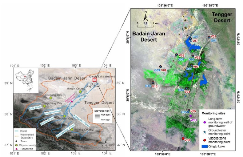
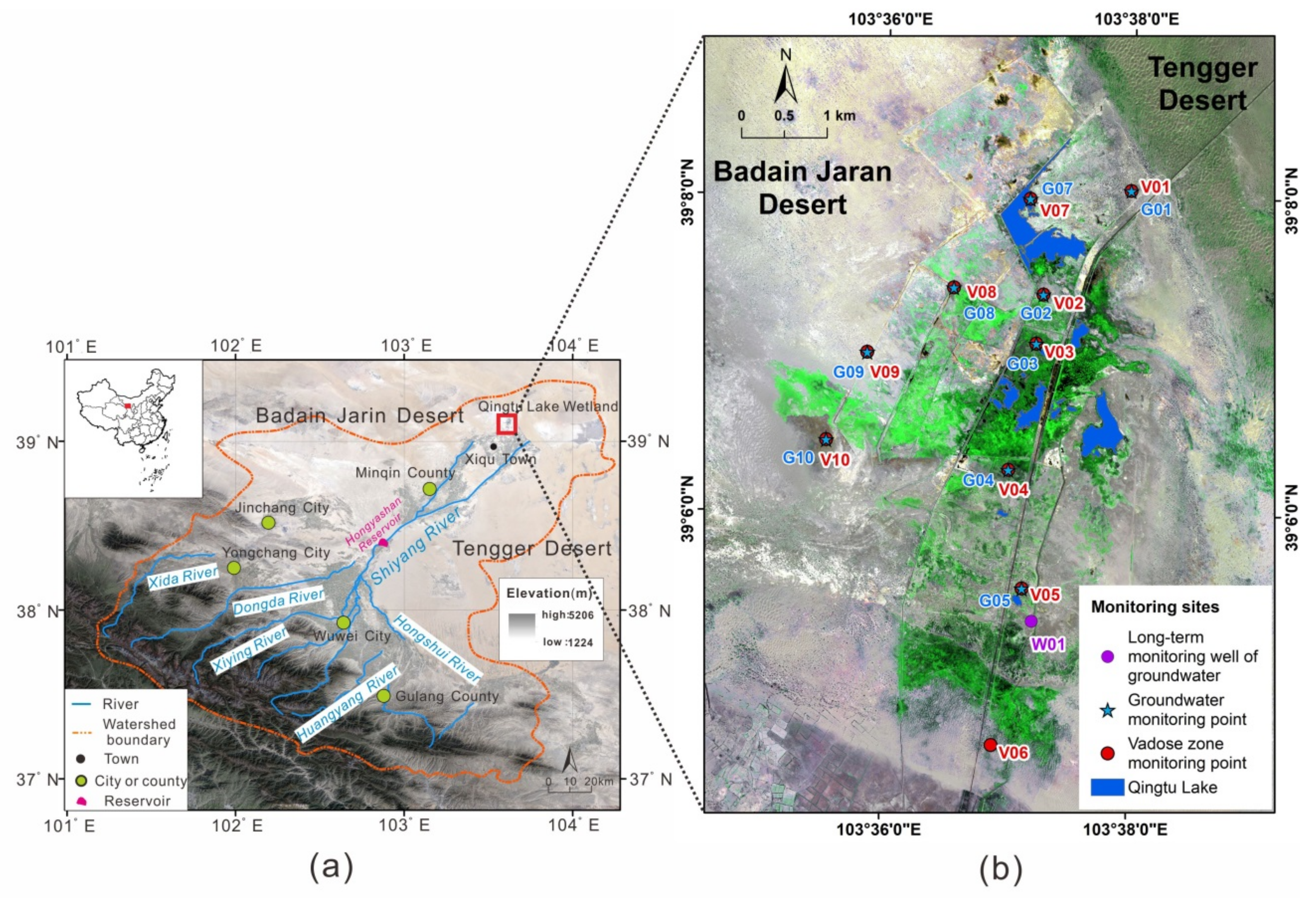
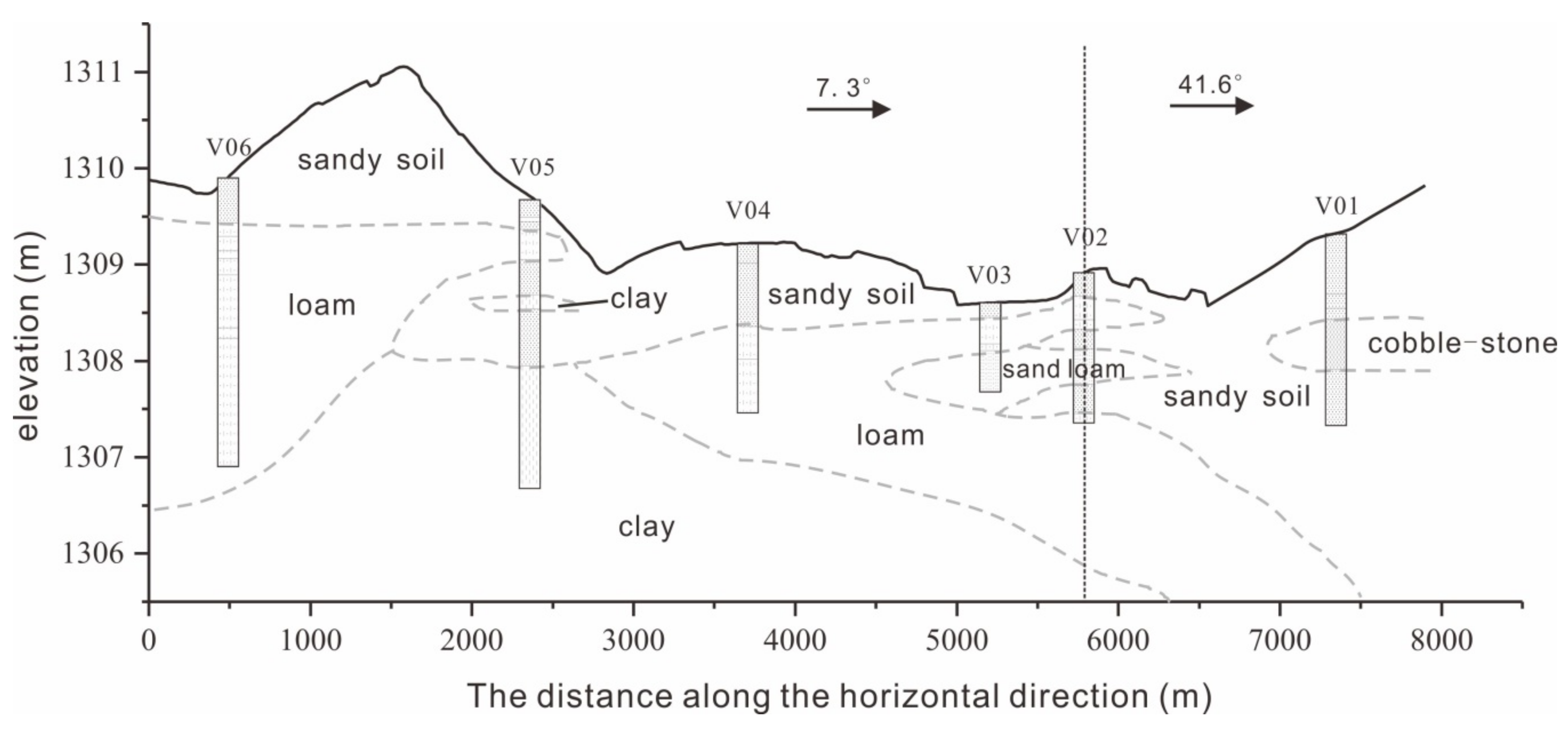
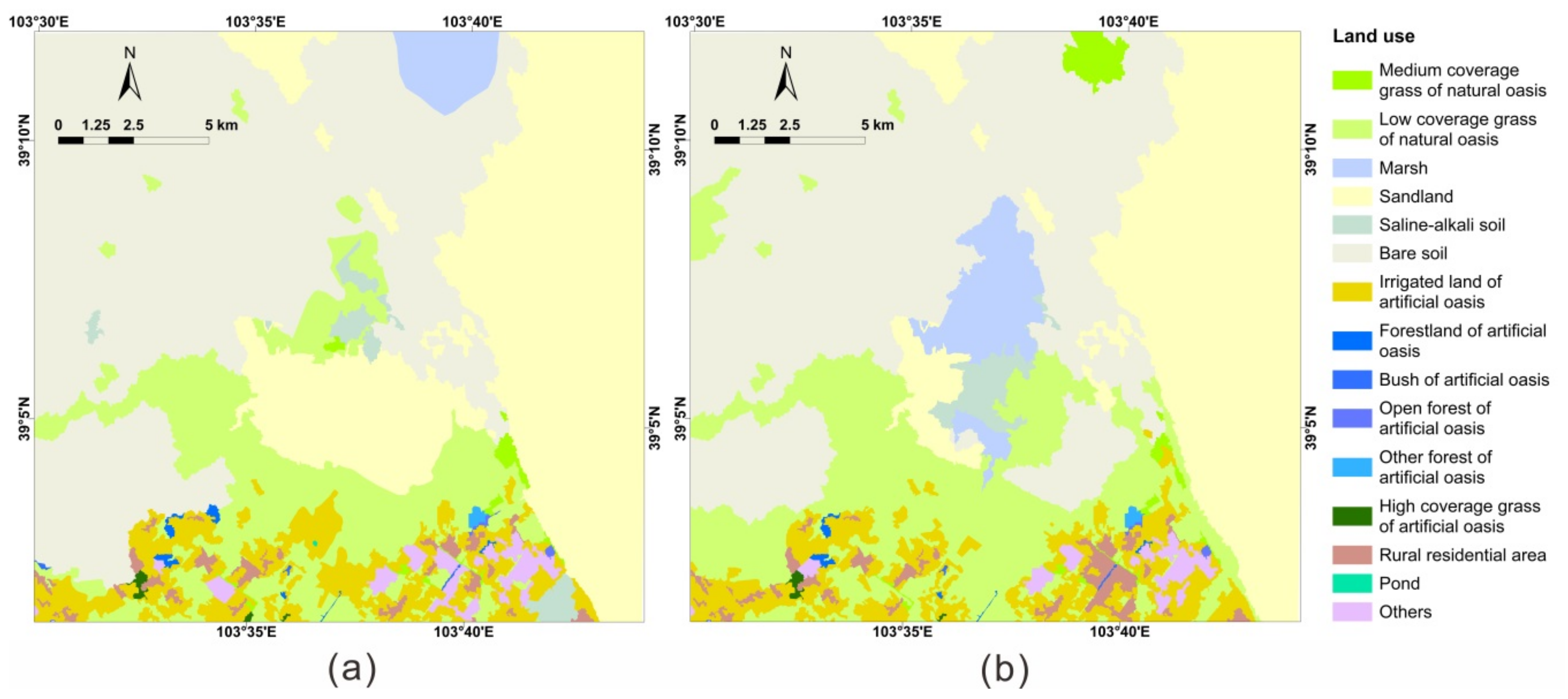
2. Study Area
3. Data and Methods
3.1. Data Sources and Preprocessing
3.2. Methods
3.2.1. Water Extraction Methods
3.2.2. Method for FVC Estimation
3.2.3. Classification Method of FVC
3.2.4. Correlation Analysis
4. Result
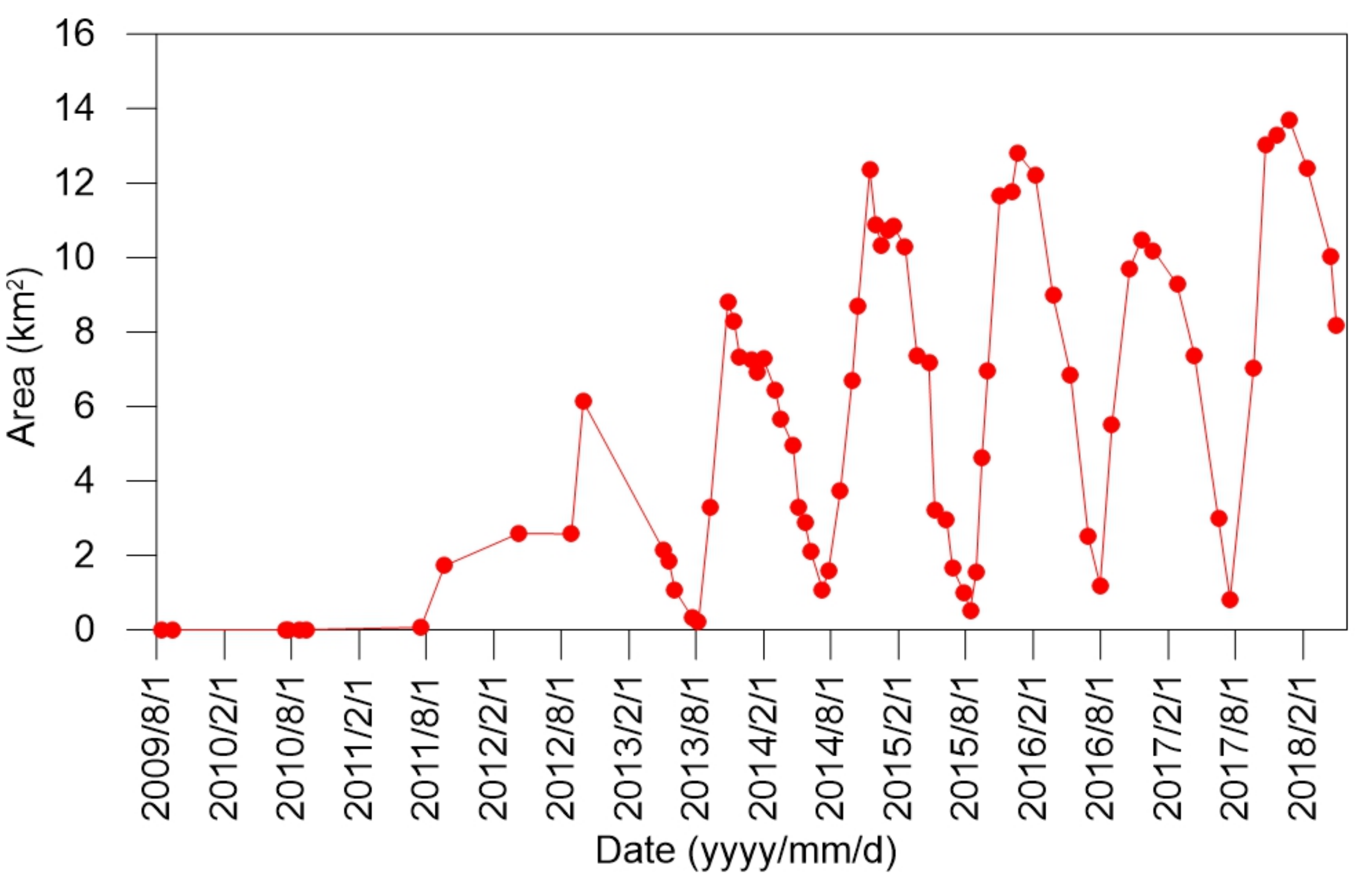
4.1. Spatial and Temporal Variations of the Water Body Area of Qingtu Lake from 2009 to 2018
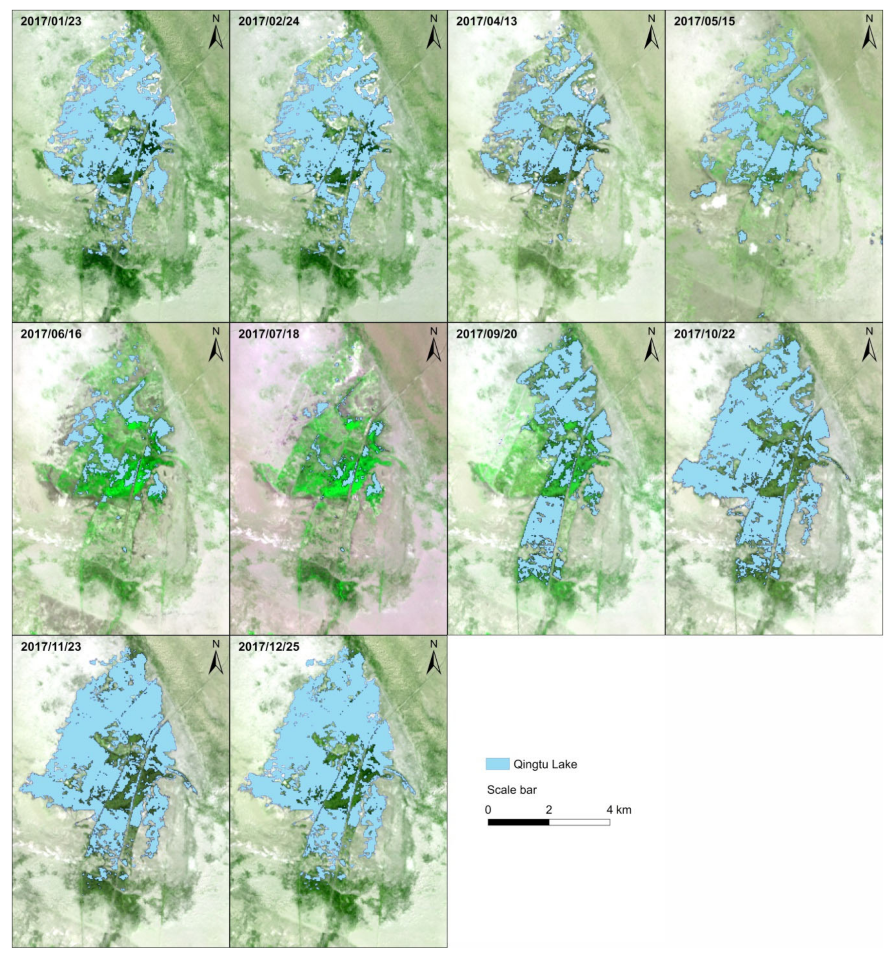
4.1.1. Temporal Change
4.1.2. Spatial Change
4.2. Variation of Groundwater Level and Soil Water Saturation in Qingtu Lake Wetland Area
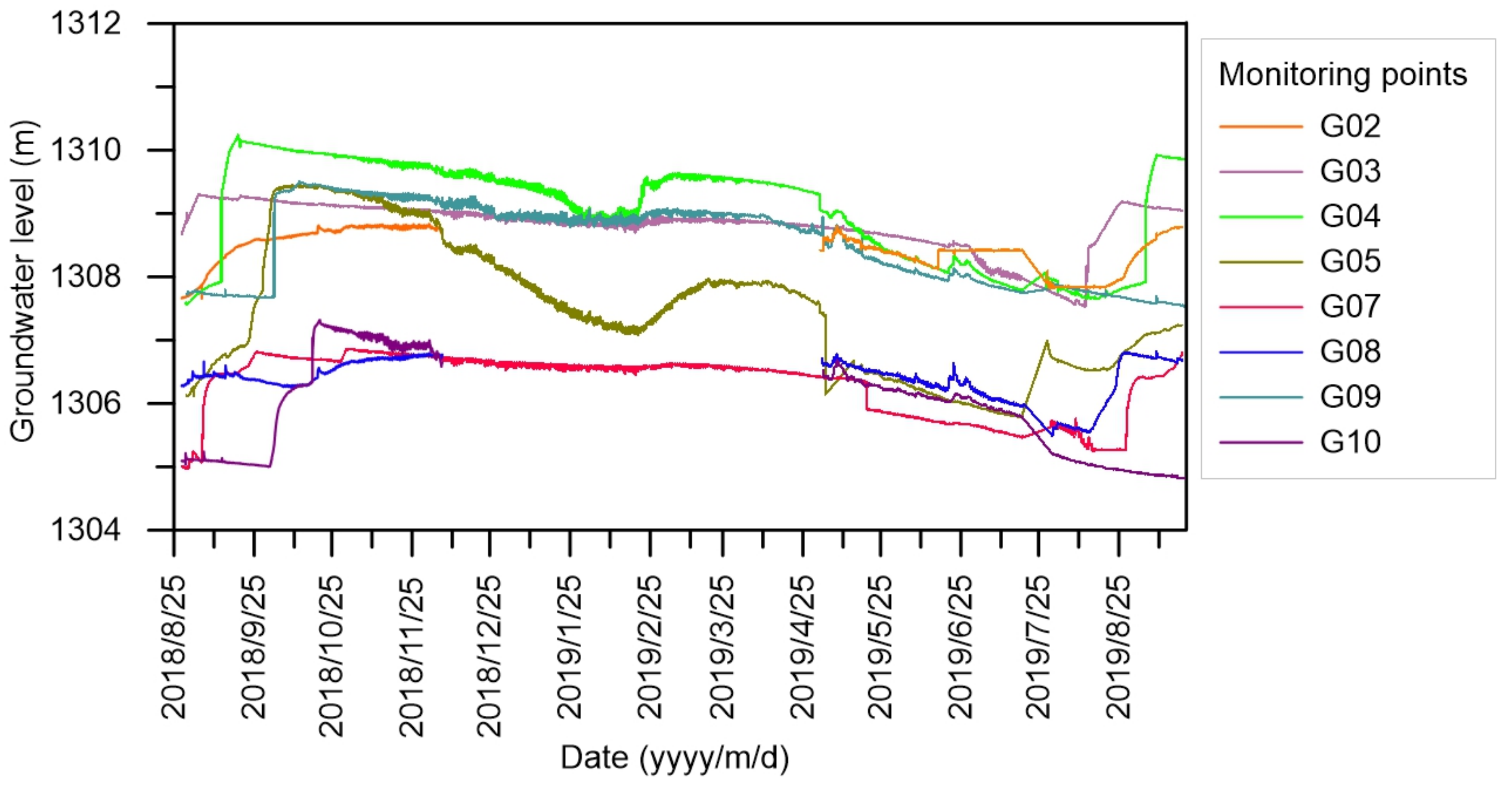
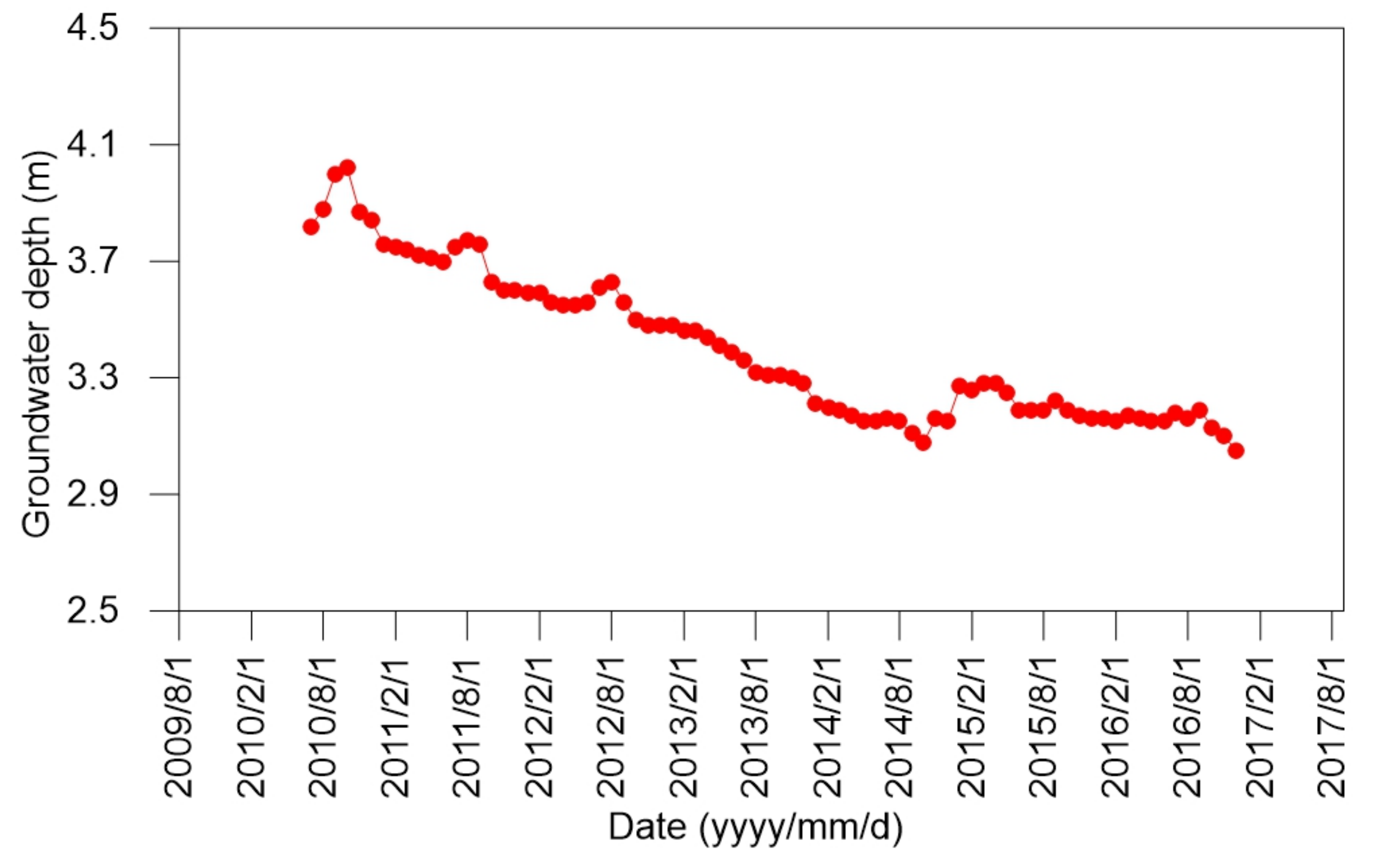
4.2.1. Variation of the Groundwater Level
4.2.2. Variation in Soil Water Saturation
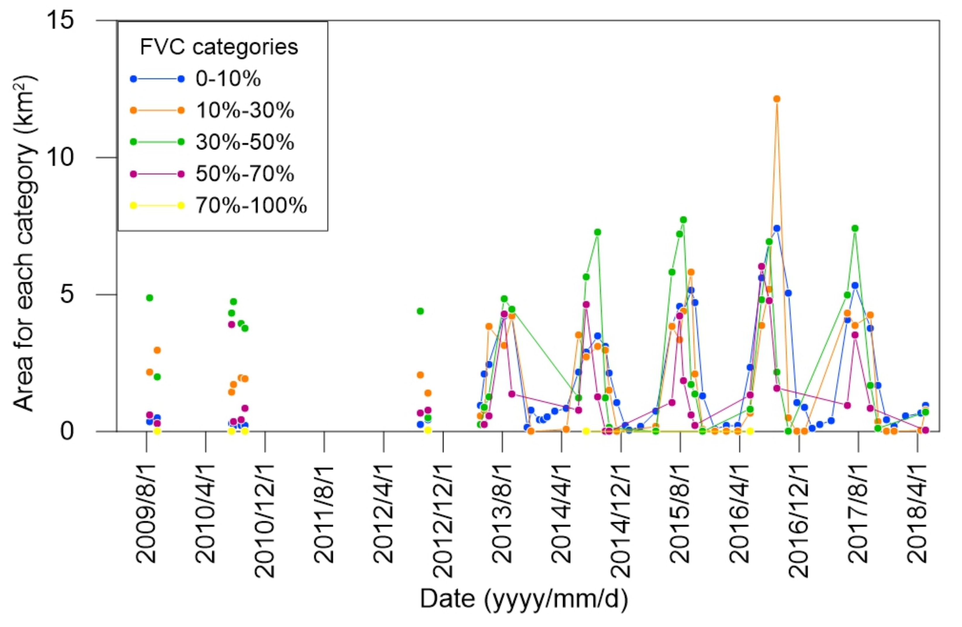
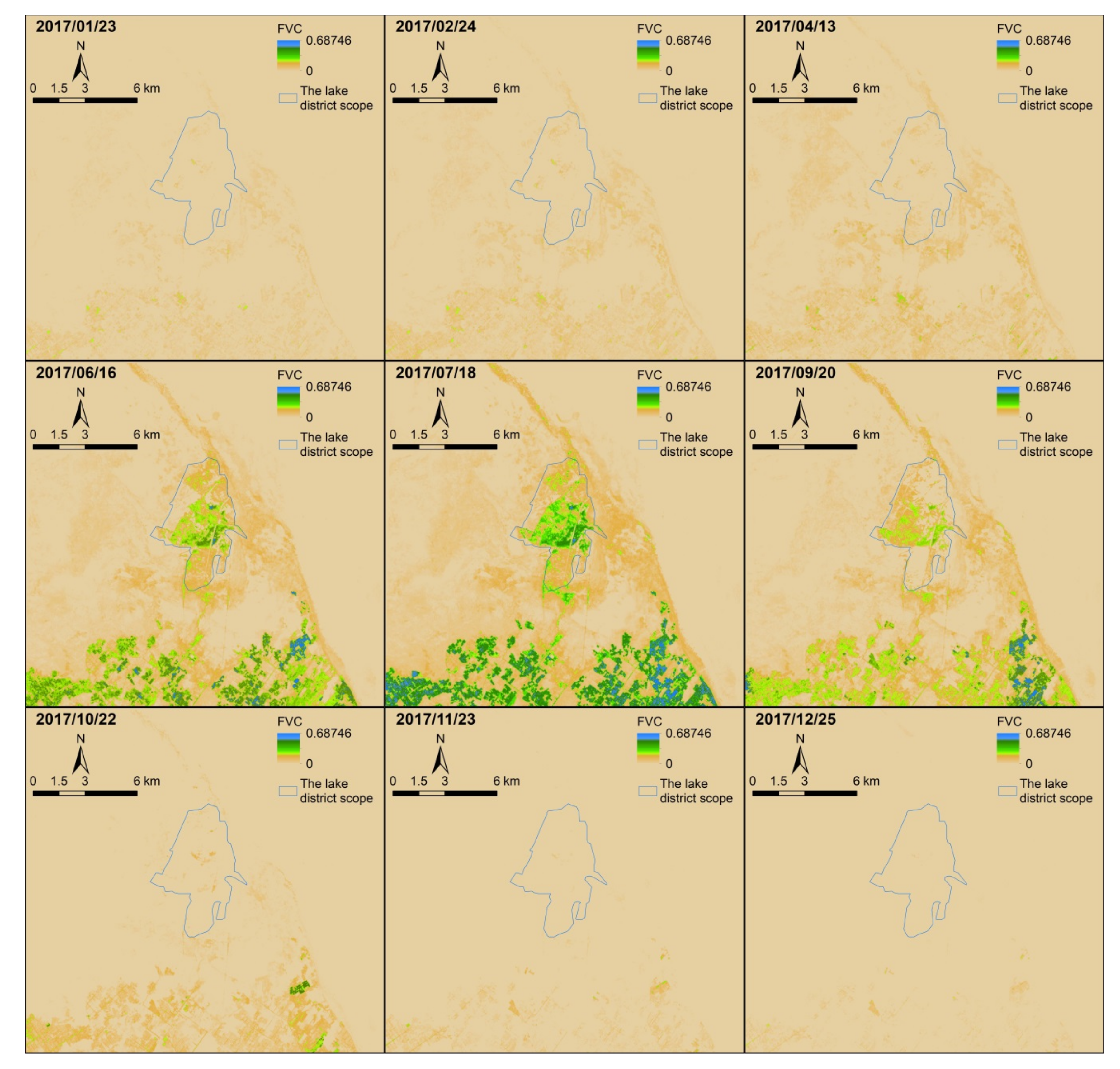
4.3. Variation in Vegetation Coverage around Qingtu Lake Wetland and Mingqin Basin
4.4. Spatial Distribution of Vegetation Coverage in Qingtu Lake Wetland Area
5. Discussion
6. Conclusions
Author Contributions
Funding
Acknowledgments
Conflicts of Interest
References
- Hou, X.; Zhang, J.; Huang, T. Rational exploitation of large wellfields based on ecological water demand in arid inland basins. Fresenius Environ. Bull. 2016, 25, 3003–3011. [Google Scholar]
- Xiu, L.; Yan, C.; Li, X.; Qian, D.; Feng, K. Changes in wetlands and surrounding land cover in a desert area under the influences of human and climatic factors: A case study of the Hongjian Nur region. Ecol. Indic. 2019, 101, 261–273. [Google Scholar] [CrossRef]
- Xu, W.; Su, X. Challenges and impacts of climate change and human activities on groundwater-dependent ecosystems in arid areas—A case study of the Nalenggele alluvial fan in NW China. J. Hydrol. 2019, 573, 376–385. [Google Scholar] [CrossRef]
- Yu, X.; Zhuge, Y.; Li, G.; Du, Q.; Zhang, D.; Tan, H.; Zhang, S. A Study of the Ecological Effects of Water Supplement Conditions in Ebinur Lake. Appl. Ecol. Environ. Res. 2018, 16, 7777–7790. [Google Scholar] [CrossRef]
- Brandis, K.J.; Bino, G.; Spencer, J.A.; Ramp, D.; Kingsford, R.T. Decline in colonial waterbird breeding highlights loss of Ramsar wetland function. Biol. Conserv. 2018, 225, 22–30. [Google Scholar] [CrossRef]
- Lopez-Porras, G.; Stringer, L.C.; Quinn, C.H. Corruption and conflicts as barriers to adaptive governance: Water governance in dryland systems in the Rio del Carmen watershed. Sci. Total Environ. 2019, 660, 519–530. [Google Scholar] [CrossRef]
- Mendez-Estrella, R.; Romo-Leon, J.; Castellanos, A.; Gandarilla-Aizpuro, F.; Hartfield, K. Analyzing Landscape Trends on Agriculture, Introduced Exotic Grasslands and Riparian Ecosystems in Arid Regions of Mexico. Remote Sens. 2016, 8, 664. [Google Scholar] [CrossRef]
- Lamsal, P.; Atreya, K.; Ghosh, M.K.; Pant, K.P. Effects of population, land cover change, and climatic variability on wetland resource degradation in a Ramsar listed Ghodaghodi Lake Complex, Nepal. Environ. Monit. Assess. 2019, 191, 415. [Google Scholar] [CrossRef]
- Mutiga, J.K.; Mavengano, S.T.; Zhongbo, S.; Woldai, T.; Becht, R. Water Allocation as a Planning Tool to Minimise Water Use Conflicts in the Upper Ewaso Ng’iro North Basin, Kenya. Water Resour. Manag. 2010, 24, 3939–3959. [Google Scholar] [CrossRef]
- Maleki, S.; Soffianian, A.R.; Koupaei, S.S.; Pourmanafi, S.; Saatchi, S. Wetland restoration prioritizing, a tool to reduce negative effects of drought; An application of multicriteria-spatial decision support system (MC-SDSS). Ecol. Eng. 2018, 112, 132–139. [Google Scholar] [CrossRef]
- Alibrahim, A. Excessive use of groundwater resources in Saudi Arabia: Impacts and policy options. Ambio 1991, 20, 34–37. [Google Scholar]
- Schlesinger, W.H.; Reynolds, J.F.; Cunningham, G.L.; Huenneke, L.F.; Jarrell, W.M.; Virginia, R.A.; Whitford, W.G.J.S. Biological Feedbacks in Global Desertification. Science. 1990, 247, 1043–1048. [Google Scholar] [CrossRef] [PubMed]
- Huang, F.; Chunyu, X.; Zhang, D.; Chen, X.; Ochoa, C.G. A framework to assess the impact of ecological water conveyance on groundwater-dependent terrestrial ecosystems in arid inland river basins. Sci. Total Environ. 2020, 709, 136155. [Google Scholar] [CrossRef] [PubMed]
- Liao, S.; Xue, L.; Dong, Z.; Zhu, B.; Zhang, K.; Wei, Q.; Fu, F.; Wei, G. Cumulative ecohydrological response to hydrological processes in arid basins. Ecol. Indic. 2020, 111, 106005. [Google Scholar] [CrossRef]
- Shi, L.; Tuerxun, H.; Han, G.H. Background, Benefits and Problems of Water Conveyance to the Lower Reaches of the Tarim River. Bull. Soil Water Conserv. 2008, 28, 176–180. [Google Scholar]
- Zhang, Y.; Yu, J.; Qiao, M.; Yang, H. Effects of eco-water transfer on changes of vegetation in the lower Heihe River Basin. J. Hydraul. Eng.-ASCE. 2011, 42, 757–765. [Google Scholar]
- Chen, Z.R.; Liu, S.Z.; Liu, S.J.; Sun, T. Response of Form. Phragmites australis and Form. Nitraria tangutorum after ecological water delivery to Qingtu Lake. Pratacult. Sci. 2015, 32, 32–40. [Google Scholar]
- Zhang, B.; Wang, K.; Li, F. Study of Shiyang River water resources scheduling and Qingtu Lake Ecological Restoration. Gansu Water Resour. Hydrop. Tech. 2017, 53, 11–14. [Google Scholar]
- Shi, W.; Liu, S.; Liu, S.; Yuan, H.; Ma, J.; Liu, H.; An, F. Influence analysis of artificial water transfer on the regional ecological environment of Qingtu Lake in the lower reaches of the Shiyang River. Acta Ecol. Sin. 2017, 37, 5951–5960. [Google Scholar]
- Chunyu, X.; Huang, F.; Xia, Z.; Zhang, D.; Chen, X.; Xie, Y. Assessing the Ecological Effects of Water Transport to a Lake in Arid Regions: A Case Study of Qingtu Lake in Shiyang River Basin, Northwest China. Int. J. Environ. Res. Public Health. 2019, 16, 145. [Google Scholar] [CrossRef]
- Liu, S.; Yuan, H.; Liu, S.; Ma, J. The desert vegetation succession at bank of Qintu Lake with water body formation. Ecol. Sci. 2017, 36, 64–72. [Google Scholar]
- Zhang, X.; Tao, H. Evolution and Conservation Policy of Wetland in Qingtuhu of the Minqin County. Gansu Sci. Technol. 2011, 27, 7–9. [Google Scholar]
- Zhang, Y.; Zhu, G.; Ma, H.; Yang, J.; Pan, H.; Guo, H.; Wan, Q.; Yong, L. Effects of Ecological Water Conveyance on the Hydrochemistry of a Terminal Lake in an Inland River: A Case Study of Qingtu Lake in the Shiyang River Basin. Water. 2019, 11, 1673. [Google Scholar] [CrossRef]
- Zhao, Q. Grain-size characteristics of qingtu lake sediments and its paleaoenvironment explaination. Arid Land Geogr. 2003, 26, 1–5. [Google Scholar]
- Yang, Y.; Li, J.; Chen, F.; Burgess, J.; Li, D.; Chang, G.; Li, Y. The human mechanism research of Minqin Oasis change in the lower reaches of the Shiyang River. Geogr. Res. 2002, 21, 449–458. [Google Scholar]
- Miao, J.; Zhou, X.; Huang, T.-Z.; Zhang, T.; Zhou, Z. A Novel Inpainting Algorithm for Recovering Landsat-7 ETM+ SLC-off Images Based on the Low-Rank Approximate Regularization Method of Dictionary Learning With Nonlocal and Nonconvex Models. IEEE Trans. Geosci. Remote Sensing. 2019, 57, 6741–6754. [Google Scholar] [CrossRef]
- Yang, J.; Zhao, J.; Zhu, G.; Wang, Y.; Ma, X.; Wang, J.; Guo, H.; Zhang, Y. Soil salinization in the oasis areas of downstream inland rivers—Case Study: Minqin oasis. Quat. Int. 2020, 537, 69–78. [Google Scholar] [CrossRef]
- Du, Y.; Zhang, Y.; Ling, F.; Wang, Q.; Li, W.; Li, X. Water Bodies’ Mapping from Sentinel-2 Imagery with Modified Normalized Difference Water Index at 10-m Spatial Resolution Produced by Sharpening the SWIR Band. Remote Sens. 2016, 8, 354. [Google Scholar] [CrossRef]
- Yang, X.; Qin, Q.; Grussenmeyer, P.; Koehl, M. Urban surface water body detection with suppressed built-up noise based on water indices from Sentinel-2 MSI imagery. Remote Sens. Environ. 2018, 219, 259–270. [Google Scholar] [CrossRef]
- Xu, H. A study on information extraction of water body with the modified normalized difference water index (MNDWI). J. Remote Sens. 2005, 9, 589–595. [Google Scholar]
- Mamat, A.; Halik, M.; Keram, A.; Song, Z. Remote Sensing Monitoring of Bosten Lake Water Resources and Its Driving Factor Analysis. Xinjiang Agric. Sci. 2017, 54, 184–192. [Google Scholar]
- Liu, D.; Jia, K.; Wei, X.; Xia, M.; Zhang, X.; Yao, Y.; Zhang, X.; Wang, B. Spatiotemporal Comparison and Validation of Three Global-Scale Fractional Vegetation Cover Products. Remote Sens. 2019, 11, 2524. [Google Scholar] [CrossRef]
- Jia, K.; Liang, S.; Gu, X.; Baret, F.; Wei, X.; Wang, X.; Yao, Y.; Yang, L.; Li, Y. Fractional vegetation cover estimation algorithm for Chinese GF-1 wide field view data. Remote Sens. Environ. 2016, 177, 184–191. [Google Scholar] [CrossRef]
- Zhang, X.; Liao, C.; Li, J.; Sun, Q. Fractional vegetation cover estimation in arid and semi-arid environments using HJ-1 satellite hyperspectral data. Int. J. Appl. Earth Obs. Geoinf. 2013, 21, 506–512. [Google Scholar] [CrossRef]
- Zhao, J.; Wang, X.; Li, D. Quantitative analysis on the vegetation coverage changes of Minqin Oasis based on MODIS. J. Arid Land Resour. Environ. 2012, 26, 91–96. [Google Scholar]
- Li, M.; Wu, B.; Yan, C.; Zhou, W. Estimation of Vegetation Fraction in the Upper Basin of Miyun Reservoir by Remote Sensing. Resour. Sci. 2004, 26, 153–159. [Google Scholar]
- Jun, Z.; Jian-xia, Y.; Guo-feng, Z. Effect of Ecological Water Conveyance on Vegetation Coverage in Surrounding Area of the Qingtu Lake. Arid Zone Res. 2018, 35, 1251–1261. [Google Scholar]
- Tao, H.; Wang, D. Change of Vegetation Coverage in Shiyang River Basin 2000–2014. Chin. Agric. Sci. Bull. 2017, 33, 66–74. [Google Scholar]
- Xu, H.; Deng, Y. Dependent Evidence Combination Based on Shearman Coefficient and Pearson Coefficient. IEEE Access. 2018, 6, 11634–11640. [Google Scholar] [CrossRef]
- Zhang, J. Problems and countermeasures of water resources schedule in hongyashan reservoir. J. Gansu Agric. Univ. 2015, 23–24. [Google Scholar]
- Ochsner, T.; Horton, R.; Ren, T. Simultaneous water content, air-filled porosity, and bulk density measurements with thermo-time domain reflectometry. Soil Sci. Soc. Am. J. 2001, 65, 1618–1622. [Google Scholar] [CrossRef]
- Xue, X.; Liao, J.; Hsing, Y.; Huang, C.; Liu, F. Policies, Land Use, and Water Resource Management in an Arid Oasis Ecosystem. Environ. Manage. 2015, 55, 1036–1051. [Google Scholar] [CrossRef] [PubMed]
- Chen, Y.; Chen, Y.; Xu, C.; Ye, Z.; Li, Z.; Zhu, C.; Ma, X. Effects of ecological water conveyance on groundwater dynamics and riparian vegetation in the lower reaches of Tarim River, China. Hydrol. Process. 2010, 24, 170–177. [Google Scholar] [CrossRef]
- Wang, Y.; Zheng, C.; Ma, R. Review: Safe and sustainable groundwater supply in China. Hydrogeol. J. 2018, 26, 1301–1324. [Google Scholar] [CrossRef]
- Cheng, G.; Li, X.; Zhao, W.; Xu, Z.; Feng, Q.; Xiao, S.; Xiao, H. Integrated study of the water–ecosystem–economy in the Heihe River Basin. Natl. Sci. Rev. 2014, 1, 413–428. [Google Scholar] [CrossRef]
- Chen, X.; Hu, Q. Groundwater influences on soil moisture and surface evaporation. J. Hydrol. 2004, 297, 285–300. [Google Scholar] [CrossRef]
- Yang, K.; Wang, C. Water storage effect of soil freeze-thaw process and its impacts on soil hydro-thermal regime variations. Agric. For. Meteorol. 2019, 265, 280–294. [Google Scholar] [CrossRef]
- Wang, T.; Li, P.; Li, Z.; Hou, J.; Xiao, L.; Ren, Z.; Xu, G.; Yu, K.; Su, Y. The effects of freeze-thaw process on soil water migration in dam and slope farmland on the Loess Plateau, China. Sci. Total Environ. 2019, 666, 721–730. [Google Scholar] [CrossRef]
- Yi, J.; Zhao, Y.; Shao, M.a.; Zhang, J.; Cui, L.; Si, B. Soil freezing and thawing processes affected by the different landscapes in the middle reaches of Heihe River Basin, Gansu, China. J. Hydrol. 2014, 519, 1328–1338. [Google Scholar] [CrossRef]
- Duan, L.; Huang, M.; Zhang, L. Use of a state-space approach to predict soil water storage at the hillslope scale on the Loess Plateau, China. Catena. 2016, 137, 563–571. [Google Scholar] [CrossRef]
- Sun, Z.; Long, X.; Ma, R. Water uptake by saltcedar (Tamarix ramosissima) in a desert riparian forest: Responses to intra-annual water table fluctuation. Hydrol. Process. 2016, 30, 1388–1402. [Google Scholar] [CrossRef]
- Moore, G.; Li, F.; Kui, L.; West, J. Flood water legacy as a persistent source for riparian vegetation during prolonged drought: An isotopic study ofArundo donaxon the Rio Grande. Ecohydrology 2016, 9, 909–917. [Google Scholar] [CrossRef]


| Class | Vegetation Coverage | Status of Fractional Vegetation Coverage (FVC) | Description |
|---|---|---|---|
| 1 | extremely low | FVC ≤ 10% | Intense desertified land, bare rock, bare soil, and waters |
| 2 | low | 10% < FVC ≤ 30% | Moderately desertified land, low yield grassland, and sparse woodland |
| 3 | medium | 30% < FVC ≤ 50% | Slightly desertified land, medium grassland, low canopy woodland, and cultivated land |
| 4 | medium and high | 50% < FVC ≤ 70% | Medium and high yield grassland, forest, and cultivated land |
| 5 | high vegetation | FVC > 70% | High yield grassland, forest, and cultivated land |
| FVC | 0–10% | 10–30% | 30–50% | 50–70% | All |
|---|---|---|---|---|---|
| Correlation coefficient | 0.853 | 0.788 | 0.982 | 0.437 | 0.839 |
© 2020 by the authors. Licensee MDPI, Basel, Switzerland. This article is an open access article distributed under the terms and conditions of the Creative Commons Attribution (CC BY) license (http://creativecommons.org/licenses/by/4.0/).
Share and Cite
Qiao, S.; Ma, R.; Sun, Z.; Ge, M.; Bu, J.; Wang, J.; Wang, Z.; Nie, H. The Effect of Water Transfer during Non-growing Season on the Wetland Ecosystem via Surface and Groundwater Interactions in Arid Northwestern China. Remote Sens. 2020, 12, 2516. https://doi.org/10.3390/rs12162516
Qiao S, Ma R, Sun Z, Ge M, Bu J, Wang J, Wang Z, Nie H. The Effect of Water Transfer during Non-growing Season on the Wetland Ecosystem via Surface and Groundwater Interactions in Arid Northwestern China. Remote Sensing. 2020; 12(16):2516. https://doi.org/10.3390/rs12162516
Chicago/Turabian StyleQiao, Shufeng, Rui Ma, Ziyong Sun, Mengyan Ge, Jianwei Bu, Junyou Wang, Zheng Wang, and Han Nie. 2020. "The Effect of Water Transfer during Non-growing Season on the Wetland Ecosystem via Surface and Groundwater Interactions in Arid Northwestern China" Remote Sensing 12, no. 16: 2516. https://doi.org/10.3390/rs12162516
APA StyleQiao, S., Ma, R., Sun, Z., Ge, M., Bu, J., Wang, J., Wang, Z., & Nie, H. (2020). The Effect of Water Transfer during Non-growing Season on the Wetland Ecosystem via Surface and Groundwater Interactions in Arid Northwestern China. Remote Sensing, 12(16), 2516. https://doi.org/10.3390/rs12162516