Preliminary Evaluation and Correction of Sea Surface Height from Chinese Tiangong-2 Interferometric Imaging Radar Altimeter


Abstract
1. Introduction
2. Data
2.1. InIRA Data
2.2. Traditional Altimeter Data
2.3. ECMWF Data
3. Evaluation
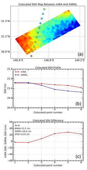
3.1. Case Sstudy
3.2. Total Colocations
4. Bias Correction
4.1. Systematic Bias Correction.
4.2. Parametric Bias Correction.
5. Discussion
6. Conclusions
Author Contributions
Funding
Acknowledgments
Conflicts of Interest
Appendix A
References
- Shum, C.; Ries, J.; Tapley, B. The accuracy and applications of satellite altimetry. Geophys. J. Int. 1995, 121, 321–336. [Google Scholar] [CrossRef]
- Chao, Y.; Fu, L. A comparison between the TOPEX/POSEIDON data and a global ocean general circulation model during 1992–1993. J. Geophys. Res. Ocean. 1995, 100, 24965–24976. [Google Scholar] [CrossRef]
- Oschlies, A.; Willebrand, J. Assimilation of Geosat altimeter data into an eddy-resolving primitive equation model of the North Atlantic Ocean. J. Geophys. Res. 1996, 101, 14175. [Google Scholar] [CrossRef]
- Wang, G.; Su, J.; Chu, P. Mesoscale eddies in the south China sea observed with altimetry. Geophys. Res. Lett. 2003, 30, 2121. [Google Scholar] [CrossRef]
- Jiang, X. Satellite microwave measurements of the global oceans and future missions. Sci. Technol. Rev. 2010, 28, 105–111. [Google Scholar] [CrossRef]
- Mitchum, G.T. Monitoring the stability of satellite altimeters with tide gauges. J. Atmos. Ocean. Technol. 1998, 15, 721–730. [Google Scholar] [CrossRef]
- Xu, X.; Xu, K.; Shen, H.; Liu, Y.; Liu, H. Sea surface height and significant wave height calibration methodology by a GNSS buoy campaign for HY-2A altimeter. IEEE J. Sel. Top. Appl. Earth Obs. Remote Sens. 2016, 9, 5252–5261. [Google Scholar] [CrossRef]
- Chen, C.; Zhu, J.; Zhai, W.; Yan, L.; Zhao, Y.; Huang, X.; Yang, W. Absolute calibration of HY-2A and Jason-2 altimeters for sea surface height using GPS buoy in Qinglan, China. J. Oceanol. Limnol. 2019, 5, 1533–1541. [Google Scholar] [CrossRef]
- Li, W.; Cardellach, E.; Fabra, F.; Ribo, S.; Rius, A. Assessment of spaceborne GNSS-R ocean altimetry performance using CYGNSS mission raw data. IEEE Trans. Geosci. Remote Sens. 2020, 58, 238–250. [Google Scholar] [CrossRef]
- Picot, N.; Case, K.; Desai, S.; Vincent, P. AVISO and PODAAC User Handbook: IGDR and GDR Jason Products, 2nd ed.; National Centre for Space Studies (CNES): Paris, France, 2003; Volume 107. [Google Scholar]
- Gómez-Enri, J.; Cipollini, P.; Gommenginger, C.; Martin-Puig, C.; Vignudelli, S.; Woodworth, P.; Villares, P. COASTALT: Improving radar altimetry products in the oceanic coastal area. SPIE Remote Sens. Ocean Sea Ice Large Water Reg. 2008, 7105. [Google Scholar] [CrossRef]
- Elachi, C.; Lm, K.E.; Li, F.K.; Rodriquez, E. Global digital topographic mapping with a synthetic aperture scanning radar altimeter. Int. J. Remote Sens. 1990, 11, 585–601. [Google Scholar] [CrossRef]
- Parsons, C.L.; Walsh, E.J.; Vandemark, D.C. Topographic mapping using a multibeam radar altimeter. IEEE Trans. Geosci. Remote Sens. 1994, 32, 1170–1178. [Google Scholar] [CrossRef][Green Version]
- Samuel, P. Performance Analysis of an Ice Topography Mission; Final Report. ESTEC Contract, 12124/96/NL/CN; NERSC: Berkeley, CA, USA, 1998. [Google Scholar]
- Raney, R.K. The delay/Doppler radar altimeter. IEEE Trans. Geosci. Remote Sens. 1988, 36, 1578–1588. [Google Scholar] [CrossRef]
- Le Roy, Y.; Deschaux-Beaume, M.; Mavrocordatos, C.; Aguirre, M.; Heliere, F. SRAL SAR radar altimeter for sentinel-3 mission. In Proceedings of the IEEE International Geoscience and Remote Sensing Symposium, Barcelona, Spain, 23–28 July 2007; pp. 23–28. [Google Scholar] [CrossRef]
- Fjortoft, R.; Gaudin, J.M.; Pourthie, N.; Lalaurie, J.C.; Mallet, A.; Nouvel, J.F.; Daniel, S. KaRIn on SWOT: Characteristics of near-nadir Ka-band interferometric SAR imagery. IEEE Trans. Geosci. Remote Sens. 2004, 52, 2172–2185. [Google Scholar] [CrossRef]
- Chevalier, L.; Desroches, D.; Laignel, B.; Fjørtoft, R.; Turki, I.; Allain, D.; Lyard, F.; Blumstein, D.; Salameh, E. High-Resolution SWOT simulations of the macrotidal seine estuary in different hydrodynamic conditions. IEEE Geosci. Remote Sens. Lett. 2019, 16, 5–9. [Google Scholar] [CrossRef]
- Ubelmann, C.; Fu, L.L.; Brown, S.; Peral, E.; Esteban-Fernandez, D. The effect of atmospheric water vapor content on the performance of future wide-swath ocean altimetry measurement. J. Atmos. Ocean. Technol. 2014, 31, 1446–1454. [Google Scholar] [CrossRef]
- Zhang, Y.; Jiang, J.; Zhang, H.; Zhang, D. Spaceborne imaging altimeter for topographic mapping. In Proceedings of the IEEE Geoscience and Remote Sensing Symposium, Honolulu, HI, USA, 24–28 July 2000; Volume 5, pp. 2349–2351. [Google Scholar] [CrossRef]
- Zhang, Y.; Jiang, J.; Zhang, X.; Xu, K.; Yan, J.; Jiang, C.; Lei, L. Design and preliminary experiment of China imaging altimeter. Microw. Remote Sens. Atmos. Environ. III 2003, 4894, 190–198. [Google Scholar] [CrossRef]
- Zhang, Y.; Zhang, X.; Meng, X.; Luo, W.; Zhou, Z.; Jiang, J. An interferometric imaging altimeter applied for both ocean and land observation. In Proceedings of the IEEE Geoscience and Remote Sensing Symposium, Barcelona, Spain, 23–28 July 2007; pp. 3821–3824. [Google Scholar] [CrossRef]
- Ren, L.; Yang, J.; Zheng, G.; Wang, J. Wind speed retrieval from Ku-band Tropical Rainfall Mapping Mission precipitation radar data at low incidence angles. J. Appl. Remote Sens. 2016, 10, 016012. [Google Scholar] [CrossRef]
- Yang, J.; Ren, L.; Zheng, G. The first quantitative ocean remote sensing by using Chinese interferometric imaging radar altimeter onboard TG-2. Acta Oceanol. Sin. 2017, 36, 122–123. [Google Scholar] [CrossRef]
- Ren, L.; Yang, J.; Jia, Y.; Dong, X.; Wang, J.; Zheng, G. Sea surface wind speed retrieval and validation of the interferometric imaging radar altimeter aboard the Chinese tiangong-2 space laboratory. IEEE J. Sel. Top. Appl. Earth Obs. Remote Sens. 2018, 99, 1–7. [Google Scholar] [CrossRef]
- Zhang, Y.; Dong, X.; Shi, X.; Zhai, W.; Yang, Q.; Li, D.; Jiang, J. Demonstration of ocean target detection by Tiangong-2 interferometric imaging radar altimeter. In Proceedings of the International Microwave and Radar Conference, Poznan, Poland, 14–17 May 2018; pp. 261–264. [Google Scholar] [CrossRef]
- Kong, W.; Chong, J.; Tan, H. Performance analysis of ocean surface topography altimetry by ku-band near-nadir interferometric SAR. Remote Sens. 2017, 9, 933. [Google Scholar] [CrossRef]
- Chen, Y.; Huang, M.; Wang, X.; Huang, H. Error analysis of dynamic sea surface height measurement by near-nadir interferometric SAR. J. Electron. Inf. Technol. 2020, 42, 547–554. [Google Scholar] [CrossRef]
- Dong, X.; Zhang, Y.; Zhai, W. Design and algorithms of the Tiangong-2 interferometric imaging radar altimeter processor. In Proceedings of the Progress in Electromagnetics Research Symposium, St. Petersburg, Russia, 22–25 May 2017; pp. 3802–3803. [Google Scholar] [CrossRef]
- Faugere, Y.; Dorandeu, J.; Lefevre, F.; Picot, N.; Femenias, P. Envisat ocean altimetry performance assessment and cross-calibration. Sensors 2006, 6, 100–130. [Google Scholar] [CrossRef]
- Labroue, S.; Boy, F.; Picot, N.; Urvoy, M.; Ablain, M. First quality assessment of the Cryosat-2 altimetric system over ocean. Adv. Space Res. 2012, 50, 1030–1045. [Google Scholar] [CrossRef]
- Bao, L.; Gao, P.; Peng, H.; Jia, Y.; Shum, C.K.; Lin, M.; Guo, Q. First accuracy assessment of the HY-2A altimeter sea surface height observations: Cross-calibration results. Adv. Space Res. 2015, 55, 90–105. [Google Scholar] [CrossRef]
- Jiang, M.; Xu, K.; Liu, Y.; Zhao, J.; Wang, L. Assessment of reprocessed sea surface height measurements derived from HY-2A radar altimeter and its application to the observation of 2015–2016 El Niño. Acta Oceanol. Sin. 2018, 37, 115–129. [Google Scholar] [CrossRef]
- Cui, W.; Wang, W.; Jie, Z.; Yang, J.; Jia, Y. Improvement of sea surface height measurements of HY-2a satellite altimeter using Jason-2. Mar. Geod. 2018, 41, 632–648. [Google Scholar] [CrossRef]
- Jiang, X.; Jia, Y.; Zhang, Y. Measurement analyses and evaluations of sea-level heights using the HY-2A satellite’s radar altimeter. Acta Oceanol. Sin. 2019, 38, 134–139. [Google Scholar] [CrossRef]
- Chelton, D.B. The sea state bias in altimeter estimates of sea level from collinear analysis of TOPEX data. J. Geophys. Res. Ocean. 1994, 99, 24995–25008. [Google Scholar] [CrossRef]
- Sun, X.; Zhang, Y.; Dong, X.; Zhai, W. Inversion of the baseline incline angle for Tiangong-2 Interferometric Imaging Radar Altimeter. Remote Sens. Technol. Appl. 2019, 34, 331–336. [Google Scholar] [CrossRef]


| Number | Traditional Altimeter Type | InIRA Time (UTC) | Traditional Altimeter Time (UTC) |
|---|---|---|---|
| 1 | Jason-2 | 2018-02-12 12:36:34 | 2018-02-12 13:20:23 |
| 2 | Jason-2 | 2017-07-22 08:24:36 | 2017-07-22 08:26:50 |
| 3 | Jason-2 | 2017-10-20 12:11:04 | 2017-10-20 12:38:25 |
| 4 | Saral/AltiKa | 2018-03-23 13:40:23 | 2018-03-23 13:44:47 |
| 5 | Saral/AltiKa | 2018-02-12 07:35:18 | 2018-02-12 08:09:06 |
| 6 | Saral/AltiKa | 2017-10-17 18:29:38 | 2017-10-17 18:43:19 |
| 7 | Jason-3 | 2018-03-23 13:40:23 | 2018-03-23 13:56:21 |
| Model Coefficient | ||||
|---|---|---|---|---|
| a0 | a1 | a2 | a3 | |
| (0.5, 1.5] | −178.94196323 | 103.3807699 | −20.09269648 | 1.24252407 |
| (1.5, 2.5] | −84.53051983 | 51.72502079 | −8.80839698 | 0.42226203 |
| (2.5, 3.5] | 21.70346396 | −11.44348505 | 4.25720119 | −0.46318078 |
| (3.5, 4.5] | 21.46840233 | 6.79459699 | −3.26950451 | 0.25112205 |
© 2020 by the authors. Licensee MDPI, Basel, Switzerland. This article is an open access article distributed under the terms and conditions of the Creative Commons Attribution (CC BY) license (http://creativecommons.org/licenses/by/4.0/).
Share and Cite
Ren, L.; Yang, J.; Dong, X.; Zhang, Y.; Jia, Y. Preliminary Evaluation and Correction of Sea Surface Height from Chinese Tiangong-2 Interferometric Imaging Radar Altimeter. Remote Sens. 2020, 12, 2496. https://doi.org/10.3390/rs12152496
Ren L, Yang J, Dong X, Zhang Y, Jia Y. Preliminary Evaluation and Correction of Sea Surface Height from Chinese Tiangong-2 Interferometric Imaging Radar Altimeter. Remote Sensing. 2020; 12(15):2496. https://doi.org/10.3390/rs12152496
Chicago/Turabian StyleRen, Lin, Jingsong Yang, Xiao Dong, Yunhua Zhang, and Yongjun Jia. 2020. "Preliminary Evaluation and Correction of Sea Surface Height from Chinese Tiangong-2 Interferometric Imaging Radar Altimeter" Remote Sensing 12, no. 15: 2496. https://doi.org/10.3390/rs12152496
APA StyleRen, L., Yang, J., Dong, X., Zhang, Y., & Jia, Y. (2020). Preliminary Evaluation and Correction of Sea Surface Height from Chinese Tiangong-2 Interferometric Imaging Radar Altimeter. Remote Sensing, 12(15), 2496. https://doi.org/10.3390/rs12152496