Semi-Supervised Deep Metric Learning Networks for Classification of Polarimetric SAR Data
Abstract
1. Introduction
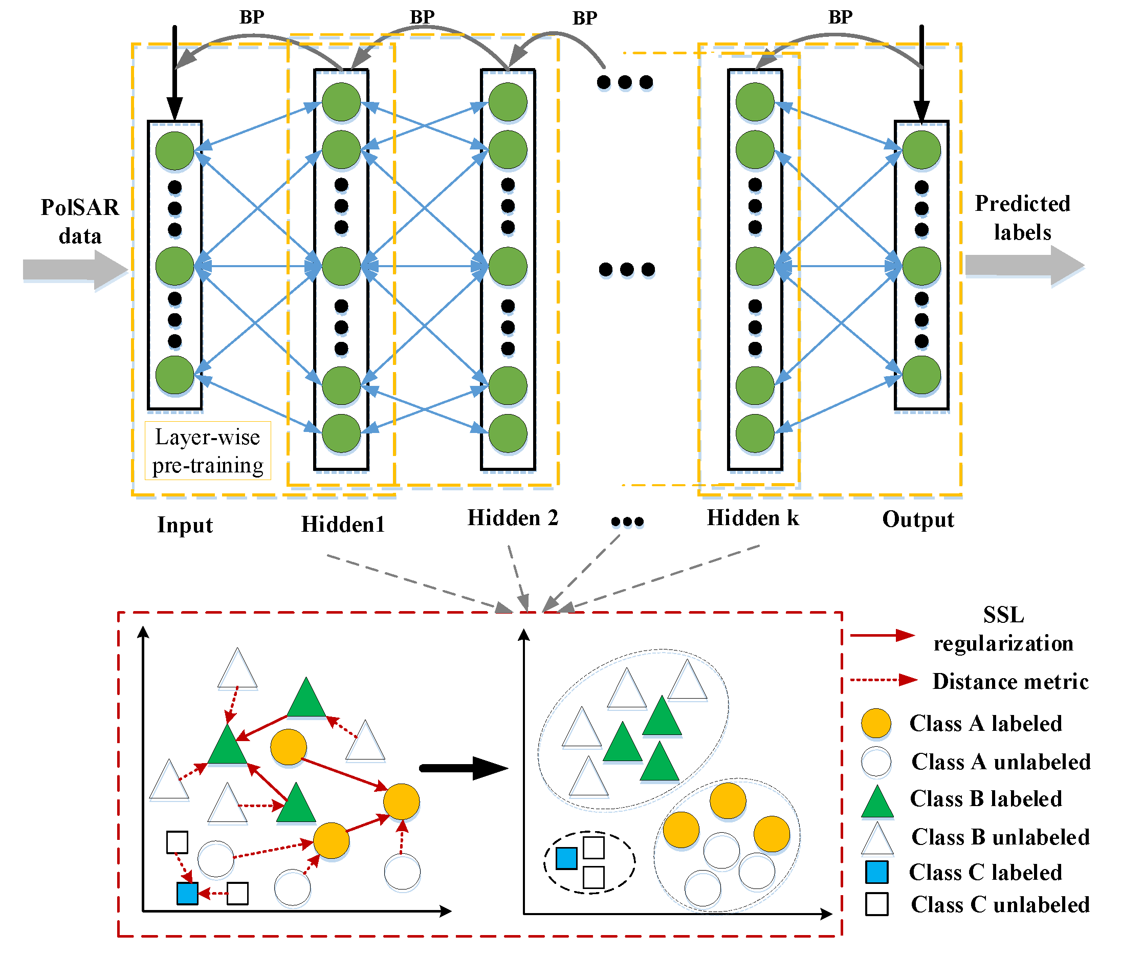
- A new deep semi-supervised metric learning network is proposed to learn the intuitive features from PolSAR data. SSDMLN maps the discriminative information from the classical metric learning into a layer-by-layer network, which enhances the classification capability of the proposed network.
- The new manifold regularization is constructed for our SSDMLN method, and it utilizes a great deal of unlabeled pixels to learn features with large discrimination capability, which greatly reduces the requirement for the labeled data for PolSAR classification.
- The proposed SSDMLN is evaluated on three datasets of the real-world PolSAR imagery from different radar sensors. It consistently improves the classification accuracy of both heterogeneous and homogeneous land types with limited labeled data.
2. Related Work
2.1. Classification Methods
2.2. Distance Metric Learning
3. Proposed Method
| Algorithm 1 SSDMLN for classification of PolSAR data |
Input:
A dataset of PolSAR with M dimensional features and N samples (L labeled samples , the rest are unlabeled ). The label denotes the vector of class labels, and V denotes the number of classes for terrains.
|
| Output: Classification result: the label matrix Y . |
4. Experimental Results and Discussions
4.1. Experimental Settings
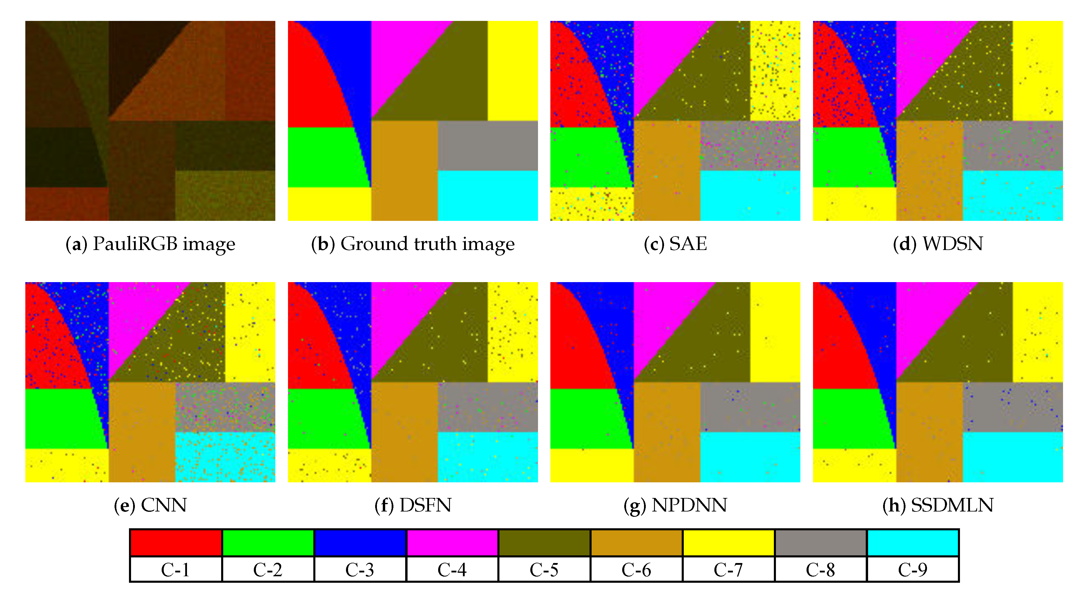
- The synthetic data is obtained by the Monte-Carlo method ([25] Ch.4.5.2) with a size of pixels, and it contains nine categories that are represented by C-1 to C-9, respectively.
- The Flevoland data set: This data set is acquired by the NASA/JPL AIRSAR system, and it is publicly available from the European Space Agency (ESA) (https://earth.esa.int/web/polsarpro/data-sources/sample-datasets). It is L-band four-look data, its resolution is 12 × 6 m, and the image size is pixels. It has 15 types of terrain: peas, stem beans, lucerne, forest, beet, potatoes, wheat, rapeseed, barley, bare soil, wheat2, grass, wheat3, buildings, and water.
- The San Francisco data set: This data set is from the RADARSAT-2 system, which is also publicly available from the ESA (https://earth.esa.int/web/polsarpro/spaceborne-data-sources). It is a C-band single-look full-polarization SAR data. The image size is pixels, which represents the bay of San Francisco with the golden gate bridge. It includes five classes: low-density urban, water, high-density urban, the developed, and vegetation.
- The Xi’an data set: This data set is imagery of the Xi’an city in China, and it is also acquired by RADARSAT-2, which is purchased by our institution. A sub-region in the western region is selected for the experiment, and the image size is pixels for our experiments.
- SAE [8]: The parameter for sparsity is between for each layer; the parameter of the sparsity penalty is set to 1; the learning rate or step-size is between .
- WDSN [9]: This network has two hidden layers, and the number of nodes for each is 50 and 100, respectively; the thresholds is , and is 0; the window size is ; and the learning rate is 0.01.
- CNN [10]: The network includes two convolutional layers, one fully connected layer and two max-pooling layers; the sizes of the first and the second convolutional filters are , and , respectively; the size of pooling is ; the momentum parameter is 0.9; the weight decay rate is .
- DSFN [16]: The rate of weight decay is chosen from the internal .
- NPDNN [17]: The nearest-neighbor number is chosen in the interval and the parameter of regularization is fixed at 1; the learning rate and weight decay rate are chosen in the range .
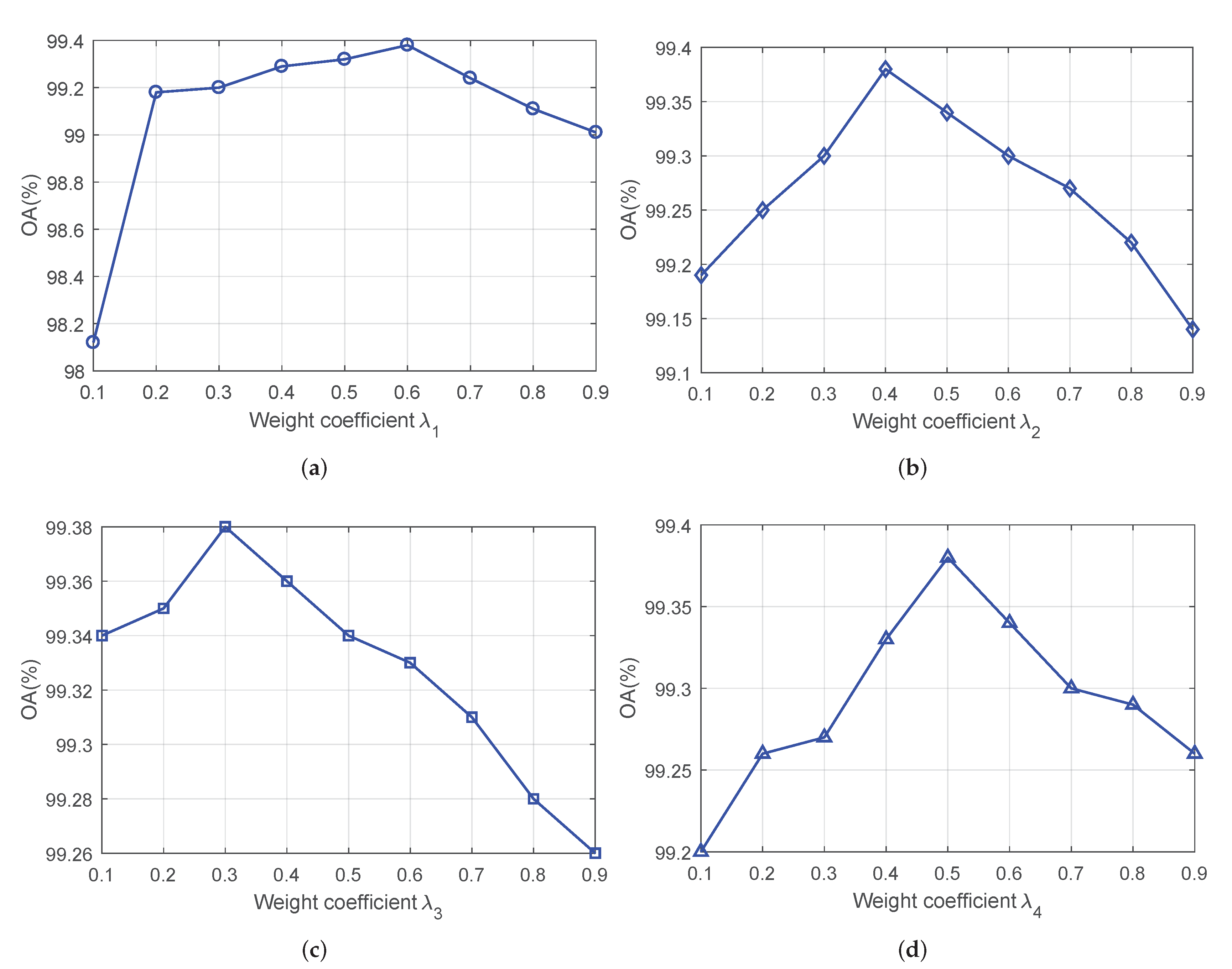
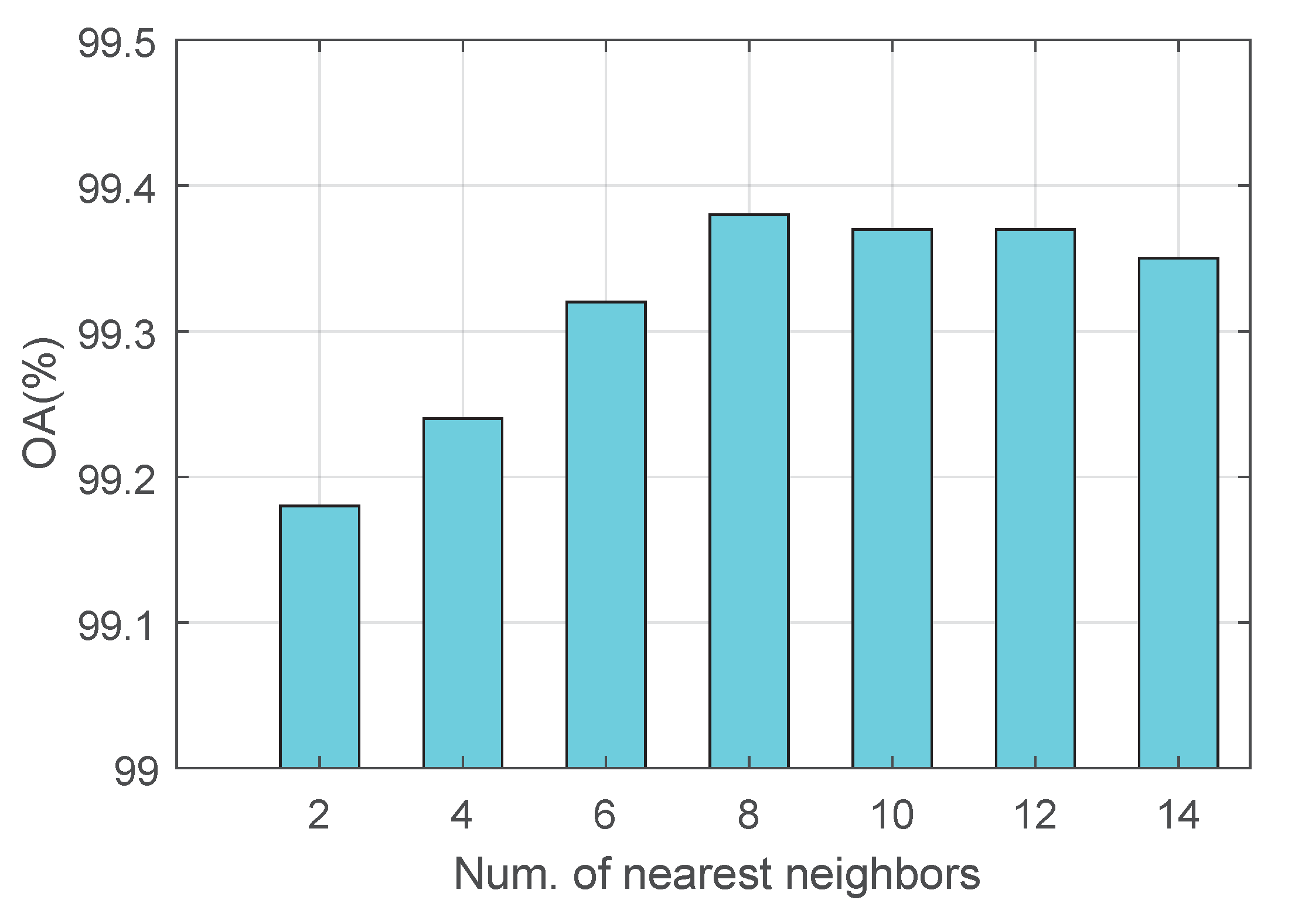
- The proposed SSDMLN: The learning rate is 0.2; the weight reduction factor is , and dropout rate is 0.5; the number of nearest neighbors is between , respectively.
4.2. Parameter Analysis
- (1)
- The weight coefficients , and
- (2)
- The number of nearest neighbors K
4.3. Experimental Results
5. Conclusions
Author Contributions
Funding
Acknowledgments
Conflicts of Interest
References
- Lee, J.S.; Grunes, M.R.; Ainsworth, T.L.; Du, L.J.; Schuler, D.L.; Cloude, S.R. Unsupervised classification using polarimetric decomposition and the complex Wishart classifier. IEEE Trans. Geosci. Remote Sens. 1999, 37, 2249–2258. [Google Scholar]
- Du, L.; Lee, J. Fuzzy classification of earth terrain covers using complex polarimetric SAR data. Int. J. Remote Sens. 1996, 17, 809–826. [Google Scholar] [CrossRef]
- Lee, J.S.; Grunes, M.R.; Pottier, E.; Ferro-Famil, L. Unsupervised terrain classification preserving polarimetric scattering characteristics. IEEE Trans. Geosci. Remote Sens. 2004, 42, 722–731. [Google Scholar]
- Liu, H.; Wang, S.; Wang, R.; Shi, J.; Zhang, E.; Yang, S.; Jiao, L. A framework for classification of urban areas using polarimetric SAR images integrating color features and statistical model. Int. J. Infrared Millim. Waves 2016, 35, 398–406. [Google Scholar]
- Fukuda, S.; Hirosawa, H. Polarimetric SAR image classification using support vector machines. IEICE Trans. Inf. Syst. 2001, 84, 1939–1945. [Google Scholar]
- Lardeux, C.; Frison, P.L.; Tison, C.; Souyris, J.C.; Stoll, B.; Fruneau, B.; Rudant, J.P. Support vector machine for multifrequency SAR polarimetric data classification. IEEE Trans. Geosci. Remote Sens. 2009, 47, 4143–4152. [Google Scholar] [CrossRef]
- Zou, T.; Yang, W.; Dai, D.; Sun, H. Polarimetric SAR image classification using multifeatures combination and extremely randomized clustering forests. EURASIP J. Adv. Signal Process. 2010, 2010, 465612. [Google Scholar] [CrossRef]
- Xie, H.; Wang, S.; Liu, K.; Lin, S.; Hou, B. Multilayer feature learning for polarimetric synthetic radar data classification. In Proceedings of the 2014 IEEE Geoscience and Remote Sensing Symposium, Quebec City, QC, Canada, 13–18 July 2014; pp. 2818–2821. [Google Scholar]
- Jiao, L.; Liu, F. Wishart deep stacking network for fast POLSAR image classification. IEEE Trans. Image Process. 2016, 25, 3273–3286. [Google Scholar] [CrossRef]
- Zhou, Y.; Wang, H.; Xu, F.; Jin, Y.Q. Polarimetric SAR image classification using deep convolutional neural networks. IEEE Geosci. Remote Sens. Lett. 2016, 13, 1935–1939. [Google Scholar] [CrossRef]
- Wei, B.; Yu, J.; Wang, C.; Wu, H.; Li, J. PolSAR image classification using a semi-supervised classifier based on hypergraph learning. Remote Sens. Lett. 2014, 5, 386–395. [Google Scholar] [CrossRef]
- Liu, H.; Wang, Y.; Yang, S.; Wang, S.; Feng, J.; Jiao, L. Large polarimetric SAR data semi-supervised classification with spatial-anchor graph. IEEE J. Sel. Top. Appl. Earth Obs. Remote Sens. 2016, 9, 1439–1458. [Google Scholar] [CrossRef]
- Liu, H.; Yang, S.; Gou, S.; Liu, S.; Jiao, L. Terrain classification based on spatial multi-attribute graph using polarimetric SAR data. Appl. Soft Comput. 2018, 68, 24–38. [Google Scholar] [CrossRef]
- Li, Y.; Xing, R.; Jiao, L.; Chen, Y.; Chai, Y.; Marturi, N.; Shang, R. Semi-Supervised PolSAR Image Classification Based on Self-Training and Superpixels. Remote Sens. 2019, 11, 1933. [Google Scholar] [CrossRef]
- Hua, W.; Wang, S.; Liu, H.; Liu, K.; Guo, Y.; Jiao, L. Semisupervised PolSAR image classification based on improved cotraining. IEEE J. Sel. Top. Appl. Earth Obs. Remote Sens. 2017, 10, 4971–4986. [Google Scholar] [CrossRef]
- Liu, H.; Min, Q.; Sun, C.; Zhao, J.; Yang, S.; Hou, B.; Feng, J.; Jiao, L. Terrain classification with polarimetric SAR based on deep sparse filtering network. In Proceedings of the 2016 IEEE International Geoscience and Remote Sensing Symposium (IGARSS), Beijing, China, 10–15 July 2016; pp. 64–67. [Google Scholar]
- Liu, H.; Yang, S.; Gou, S.; Zhu, D.; Wang, R.; Jiao, L. Polarimetric SAR feature extraction with neighborhood preservation-based deep learning. IEEE J. Sel. Top. Appl. Earth Obs. Remote Sens. 2017, 10, 1456–1466. [Google Scholar] [CrossRef]
- Yang, L.; Jin, R. Distance Metric Learning: A Comprehensive Survey; Michigan State Universiy: East Lansing, MI, USA, 2006; Volume 2, p. 4. [Google Scholar]
- Kulis, B. Metric Learning: A Survey. Found. Trends Mach. Learn. 2013, 5, 287–364. [Google Scholar] [CrossRef]
- Weinberger, K.Q.; Saul, L.K. Distance metric learning for large margin nearest neighbor classification. J. Mach. Learn. Res. 2009, 10, 207–244. [Google Scholar]
- Liu, H.; Zhu, D.; Yang, S.; Hou, B.; Gou, S.; Xiong, T.; Jiao, L. Semisupervised feature extraction with neighborhood constraints for polarimetric SAR classification. IEEE J. Sel. Top. Appl. Earth Obs. Remote Sens. 2016, 9, 3001–3015. [Google Scholar] [CrossRef]
- Liu, H.; Shang, F.; Yang, S.; Gong, M.; Zhu, T.; Jiao, L. Sparse Manifold-Regularized Neural Networks for Polarimetric SAR Terrain Classification. IEEE Trans. Neural Netw. Learn. Syst. 2019. [Google Scholar] [CrossRef]
- Liu, H.; Wang, F.; Yang, S.; Biao, H.; Licheng, J.; Yang, R. Fast Semi-supervised Classification Using Histogram-based Density Estimation for Large-scale Polarimetric SAR Data. IEEE Geosci. Remote Sens. 2019, 16, 1844–1848. [Google Scholar] [CrossRef]
- Liu, H.; Wang, Z.; Shang, F.; Yang, S.; Gou, S.; Licheng, J. Semi-supervised Tensorial Locally Linear Embedding for Feature Extraction using PolSAR Data. IEEE J-STSP 2018, 12, 1476–1490. [Google Scholar] [CrossRef]
- Lee, J.S.; Pottier, E. Polarimetric Radar Imaging: From Basics to Applications; CRC Press: Boca Raton, FL, USA, 2009. [Google Scholar]
- Lee, J.S.; Grunes, M.; de Grandi, G. Polarimetric SAR speckle filtering and its implication for classification. IEEE Trans. Geosci. Remote Sens. 1999, 37, 2363–2373. [Google Scholar]
- Bergstra, J.; Bengio, Y. Random search for hyper-parameter optimization. JMLR 2012, 13, 281–305. [Google Scholar]
- Beng, Y. Gradient-based optimization of hyperparameters. Neural Comput. 2000, 12, 1889–1900. [Google Scholar] [CrossRef]
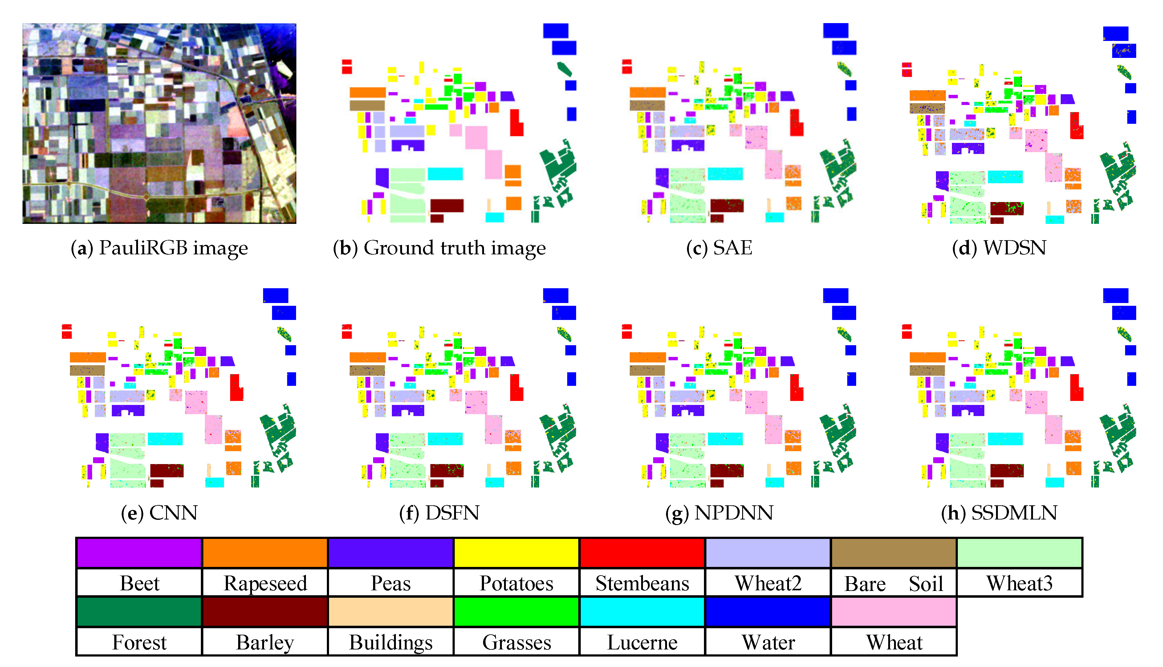

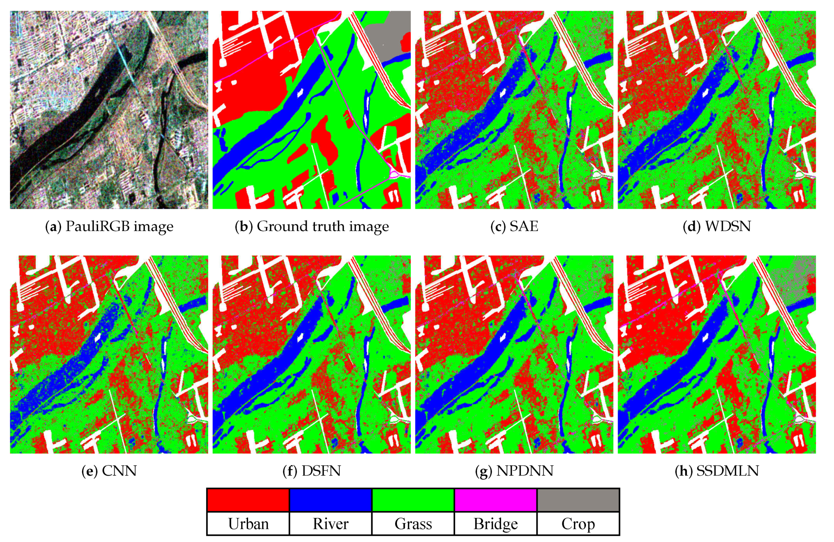
| Methods | C-1 | C-2 | C-3 | C-4 | C-5 | C-6 | C-7 | C-8 | C-9 | OA |
|---|---|---|---|---|---|---|---|---|---|---|
| SAE [8] | 96.14 | 99.47 | 92.36 | 100.0 | 98.72 | 98.99 | 92.57 | 92.21 | 99.66 | 96.15 |
| WDSN [9] | 95.37 | 98.36 | 89.56 | 97.21 | 94.38 | 89.76 | 89.32 | 90.47 | 91.89 | 92.36 |
| CNN [10] | 95.81 | 100.0 | 90.88 | 97.82 | 95.26 | 98.51 | 98.65 | 85.15 | 90.26 | 94.17 |
| DSFN [16] | 98.61 | 98.84 | 94.33 | 99.95 | 97.68 | 91.14 | 97.70 | 98.70 | 99.32 | 97.80 |
| NPDNN [17] | 98.77 | 99.85 | 96.80 | 99.95 | 98.81 | 94.98 | 99.35 | 98.37 | 99.49 | 98.70 |
| SSDMLN (ours) | 99.74 | 99.93 | 99.02 | 99.69 | 99.60 | 98.66 | 98.98 | 98.52 | 99.81 | 99.38 |
| Methods | SAE [8] | WDSN [9] | CNN [10] | DSFN [16] | NPDNN [17] | SSDMLN (ours) |
|---|---|---|---|---|---|---|
| Peas | 93.36 | 80.42 | 85.15 | 93.15 | 95.30 | 96.32 |
| Stembeans | 93.25 | 62.55 | 93.47 | 96.56 | 96.01 | 96.62 |
| Lucerne | 92.11 | 88.31 | 70.10 | 91.57 | 94.10 | 95.49 |
| Forest | 87.83 | 88.45 | 99.88 | 91.96 | 93.03 | 92.03 |
| Beet | 94.35 | 80.21 | 99.72 | 95.25 | 96.15 | 96.80 |
| Potatoes | 87.07 | 85.53 | 91.20 | 90.26 | 91.02 | 92.39 |
| Wheat | 90.24 | 79.66 | 94.99 | 91.56 | 90.46 | 92.57 |
| Rapeseed | 83.16 | 76.32 | 97.66 | 89.04 | 88.46 | 89.94 |
| Bare Soil | 94.54 | 87.89 | 97.68 | 93.14 | 97.70 | 97.54 |
| Wheat2 | 79.82 | 79.34 | 84.97 | 88.96 | 89.10 | 87.82 |
| Grasses | 73.11 | 78.06 | 45.20 | 90.53 | 82.58 | 93.08 |
| Wheat3 | 90.86 | 89.65 | 99.81 | 90.25 | 95.10 | 94.60 |
| Barley | 94.97 | 67.24 | 33.67 | 94.16 | 94.83 | 97.40 |
| Buildings | 87.59 | 86.35 | 87.35 | 91.24 | 90.35 | 92.62 |
| Water | 99.08 | 95.11 | 88.19 | 93.10 | 98.54 | 99.42 |
| OA | 88.12 | 83.41 | 88.12 | 92.25 | 93.57 | 94.85 |
| Methods | Water | Vegetation | L-Urban | H-Urban | Developed | OA |
|---|---|---|---|---|---|---|
| SAE [8] | 98.94 | 83.14 | 55.85 | 85.78 | 63.44 | 87.95 |
| WDSN [9] | 98.28 | 76.35 | 53.11 | 82.23 | 66.48 | 86.41 |
| CNN [10] | 98.84 | 81.70 | 53.71 | 85.31 | 62.28 | 87.96 |
| DSFN [16] | 99.90 | 91.62 | 55.92 | 86.46 | 68.59 | 90.00 |
| NPDNN [17] | 99.94 | 91.74 | 69.70 | 87.95 | 74.85 | 92.36 |
| SSDMLN (ours) | 99.98 | 93.55 | 75.91 | 91.15 | 81.23 | 94.49 |
| Methods | Urban | River | Grass | Bridge | Crop | OA |
|---|---|---|---|---|---|---|
| SAE [8] | 74.19 | 82.85 | 75.05 | 26.19 | 18.30 | 72.59 |
| WDSN [9] | 74.58 | 83.68 | 73.33 | 16.38 | 15.95 | 71.69 |
| CNN [10] | 75.54 | 76.01 | 74.23 | 85.31 | 12.12 | 71.40 |
| DSFN [16] | 77.01 | 86.68 | 80.79 | 17.31 | 13.78 | 76.48 |
| NPDNN [17] | 79.03 | 87.37 | 80.11 | 27.39 | 15.64 | 77.14 |
| SSDMLN (ours) | 84.43 | 86.77 | 80.59 | 34.30 | 40.13 | 82.10 |
© 2020 by the authors. Licensee MDPI, Basel, Switzerland. This article is an open access article distributed under the terms and conditions of the Creative Commons Attribution (CC BY) license (http://creativecommons.org/licenses/by/4.0/).
Share and Cite
Liu, H.; Luo, R.; Shang, F.; Meng, X.; Gou, S.; Hou, B. Semi-Supervised Deep Metric Learning Networks for Classification of Polarimetric SAR Data. Remote Sens. 2020, 12, 1593. https://doi.org/10.3390/rs12101593
Liu H, Luo R, Shang F, Meng X, Gou S, Hou B. Semi-Supervised Deep Metric Learning Networks for Classification of Polarimetric SAR Data. Remote Sensing. 2020; 12(10):1593. https://doi.org/10.3390/rs12101593
Chicago/Turabian StyleLiu, Hongying, Ruyi Luo, Fanhua Shang, Xuechun Meng, Shuiping Gou, and Biao Hou. 2020. "Semi-Supervised Deep Metric Learning Networks for Classification of Polarimetric SAR Data" Remote Sensing 12, no. 10: 1593. https://doi.org/10.3390/rs12101593
APA StyleLiu, H., Luo, R., Shang, F., Meng, X., Gou, S., & Hou, B. (2020). Semi-Supervised Deep Metric Learning Networks for Classification of Polarimetric SAR Data. Remote Sensing, 12(10), 1593. https://doi.org/10.3390/rs12101593


