FORCE—Landsat + Sentinel-2 Analysis Ready Data and Beyond


Abstract
1. Introduction
2. Product Level and Data Cube Definition
- The ‘grid’ as the regular spatial subdivision of the land surface in the target coordinate system.
- The ‘grid origin’ is the location, where the tile numbering starts with zero. Tile numbers increase toward the South and East. Although not recommended, negative tile numbers may be present if the tile origin is not North–West of the study area.
- The ‘tile’ is one entity of the grid, i.e., a grid cell with a unique tile identifier, e.g., X0003_Y0002. The tile is stationary, i.e., it always covers the same extent on the land surface.
- The ‘tile size’ is defined in target coordinate system units (most commonly in meters). Tiles are square.
- Each ‘original image’ is partitioned into several ‘chips’, i.e., any original image is intersected with the grid and then tiled into chips.
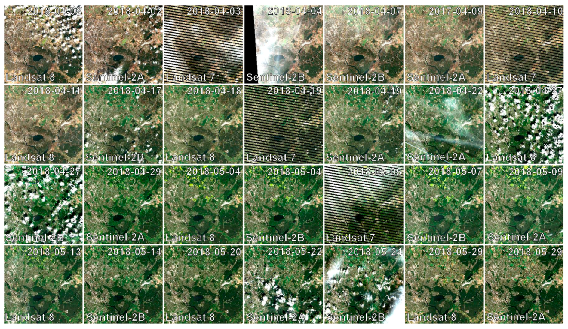
- Chips are grouped in ‘datasets’, which group data according to acquisition date and sensor. Each dataset contains several ‘products’. At minimum, a reflectance product and an accompanying quality product are generated.
- The ‘data cube’ groups all datasets within a tile in a time-ordered manner. The data cube may contain data from several sensors and different resolutions. Thus, the pixel size is allowed to vary, but the tile extent stays fixed. The data cube concept allows for non-redundant data storage and efficient data access, as well as simplified extraction of data and information.
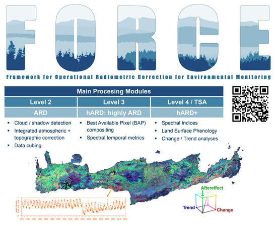
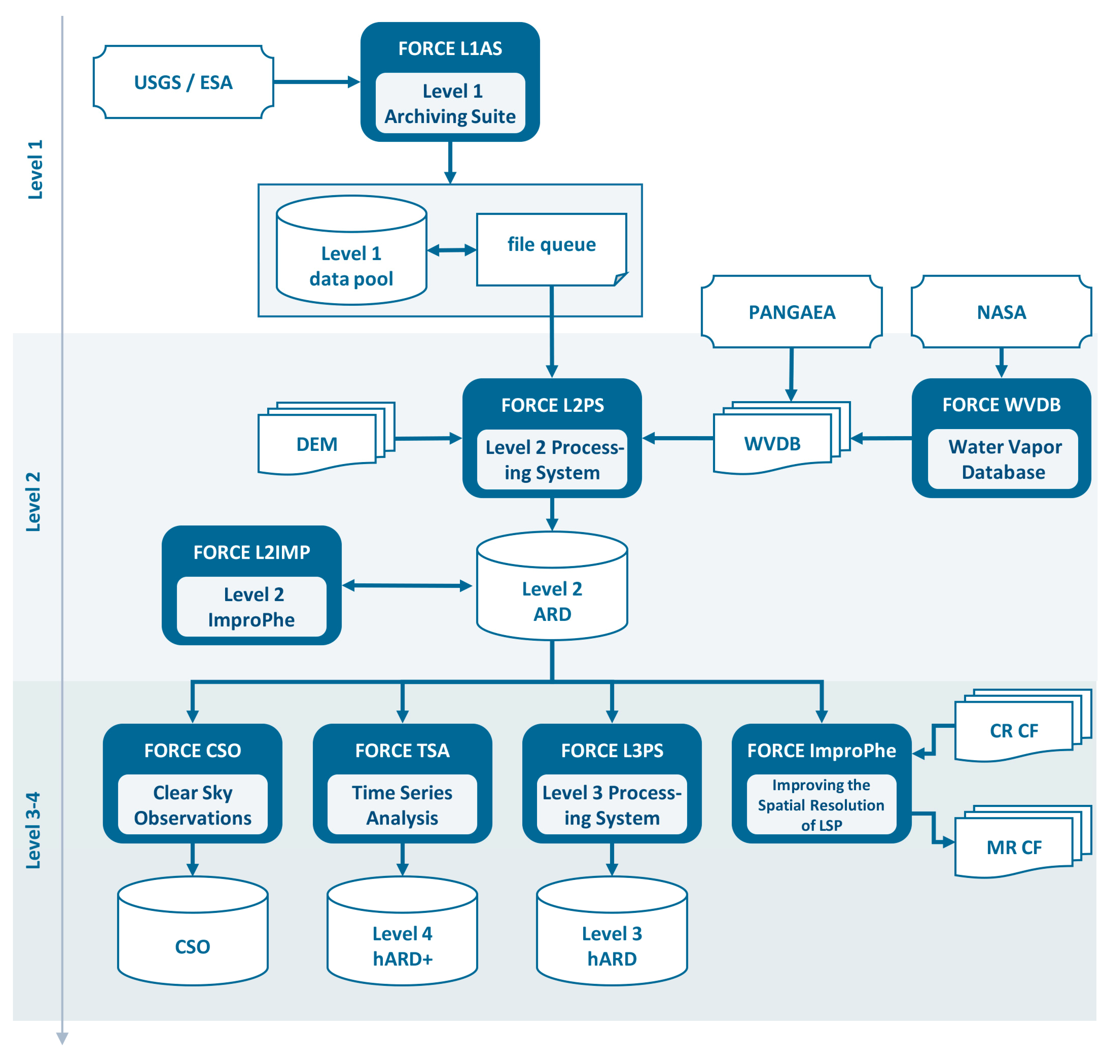
3. Processing Capability
3.1. Level 1
3.2. Level 2: Analysis Ready Data
3.2.1. Processing
3.2.2. Auxiliary Data
3.2.3. Output Format
3.3. Higher Level: Highly Analysis Ready Data
3.3.1. General Concept
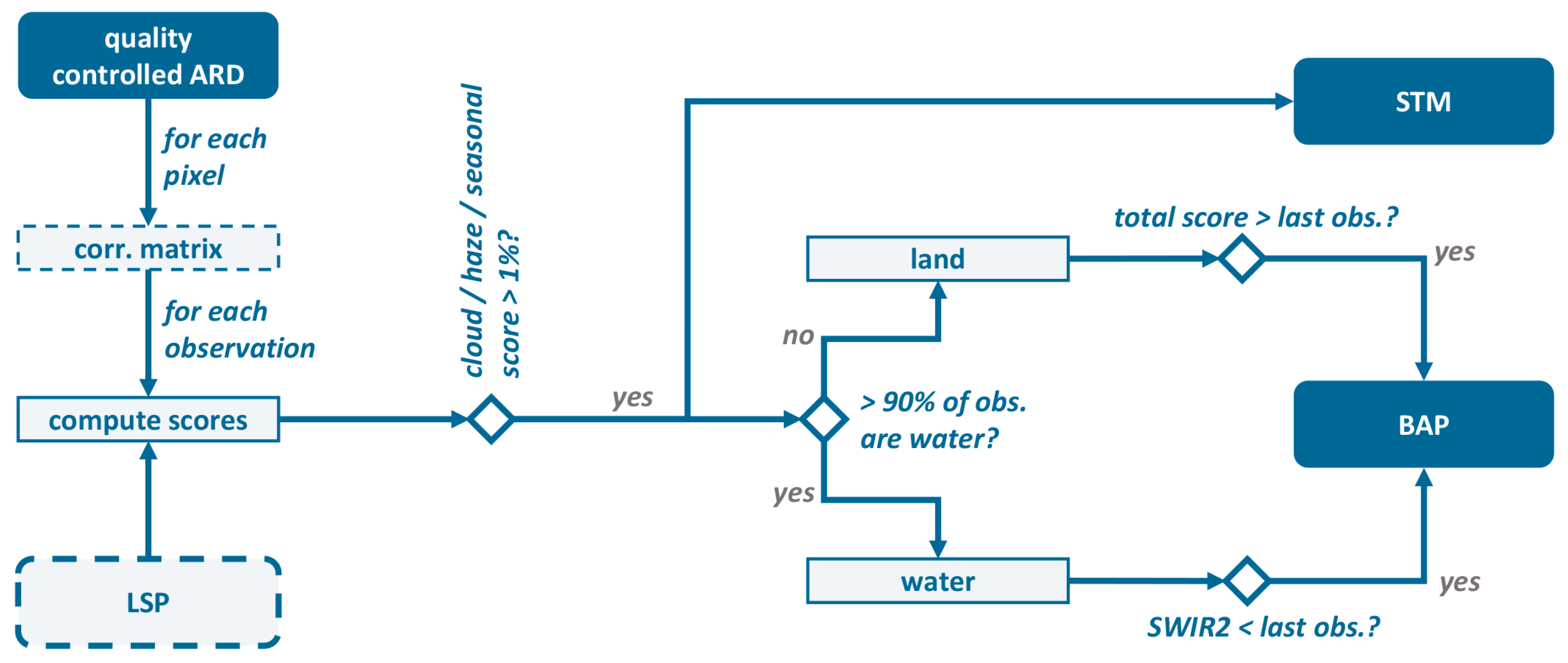
3.3.2. Clear Sky Observations
3.3.3. Level 3: Highly Analysis Ready Data
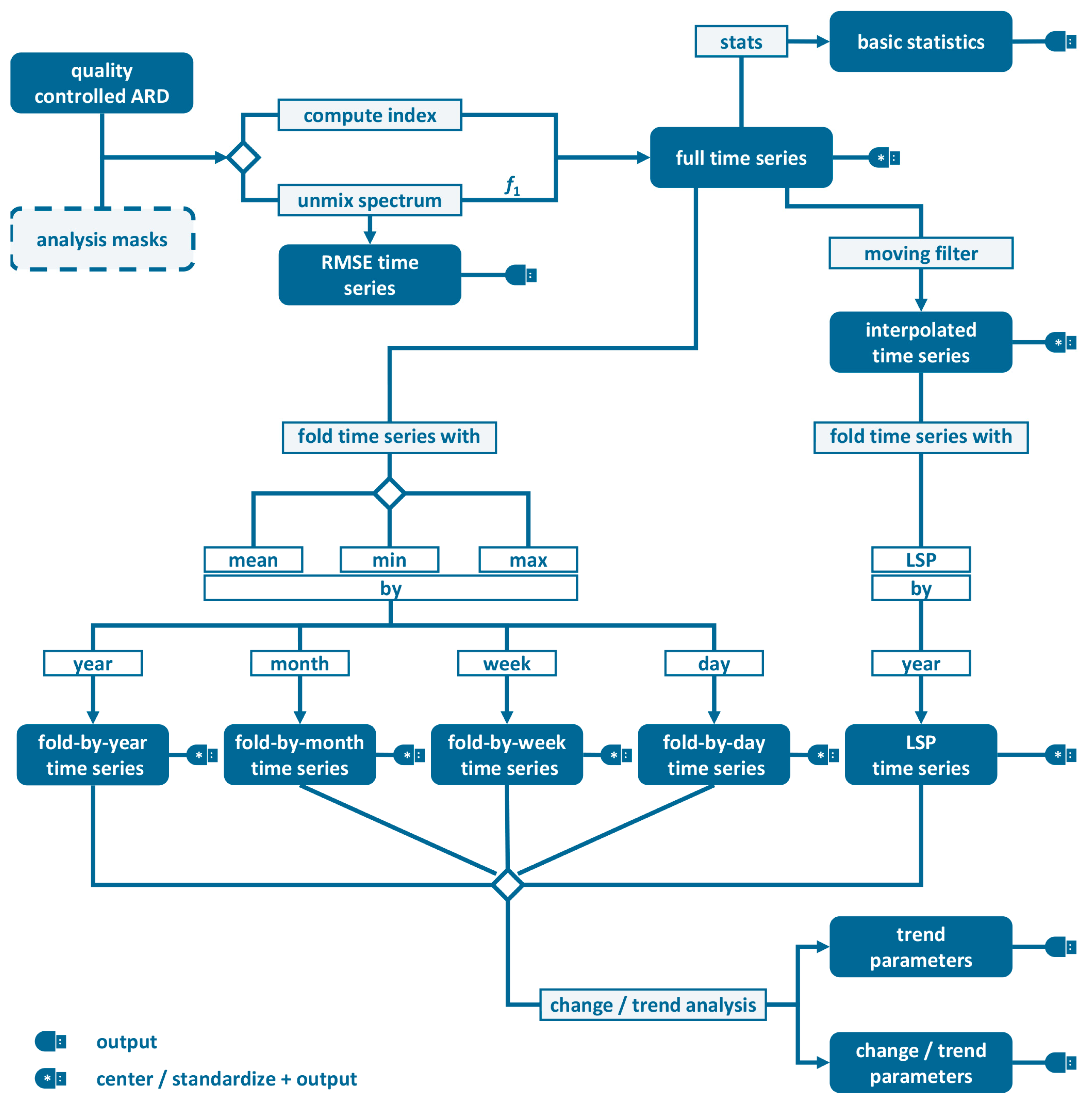
3.3.4. Time Series Analysis/Level 4 Highly Analysis Ready Data+
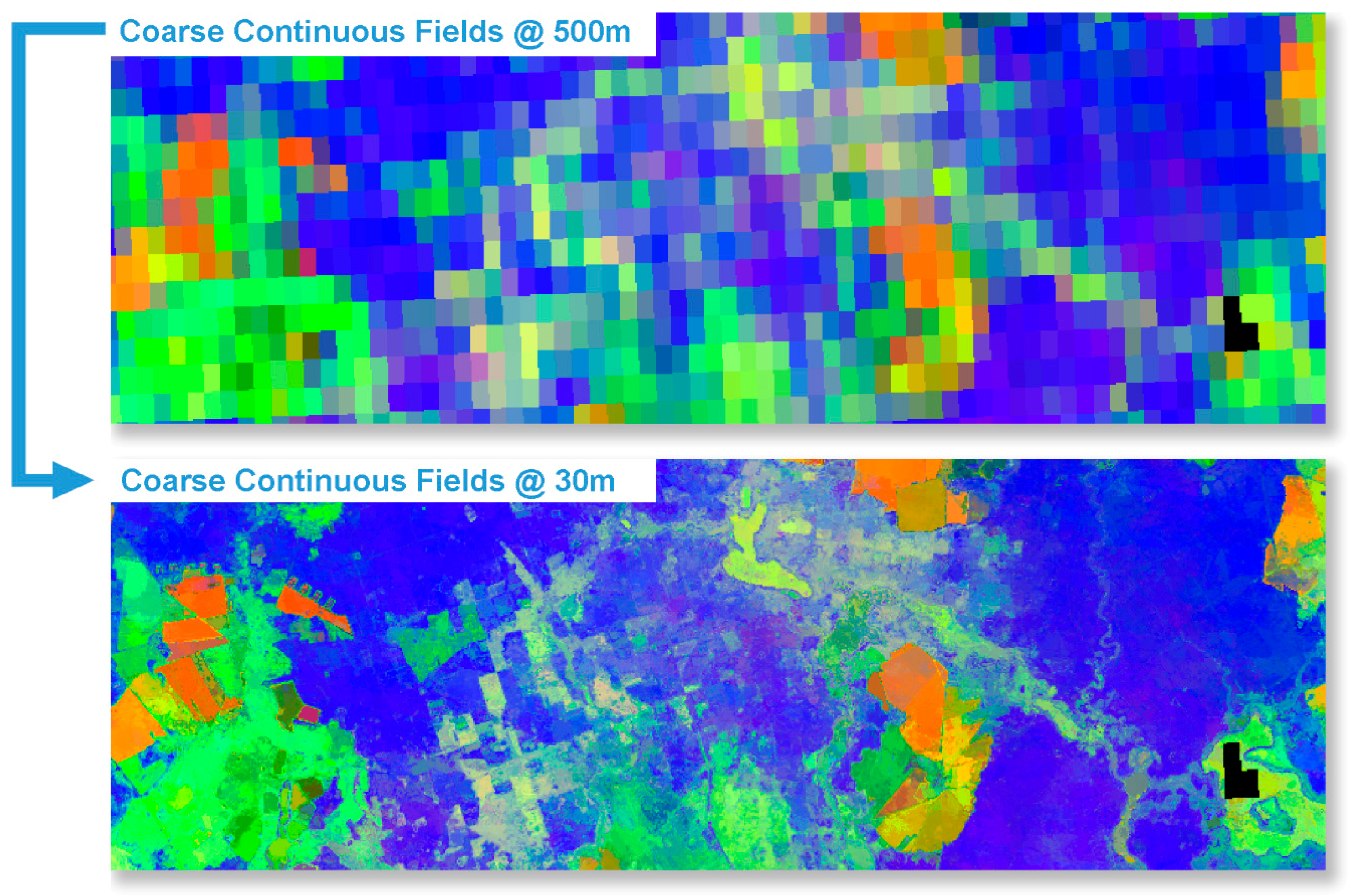
3.3.5. Data Fusion
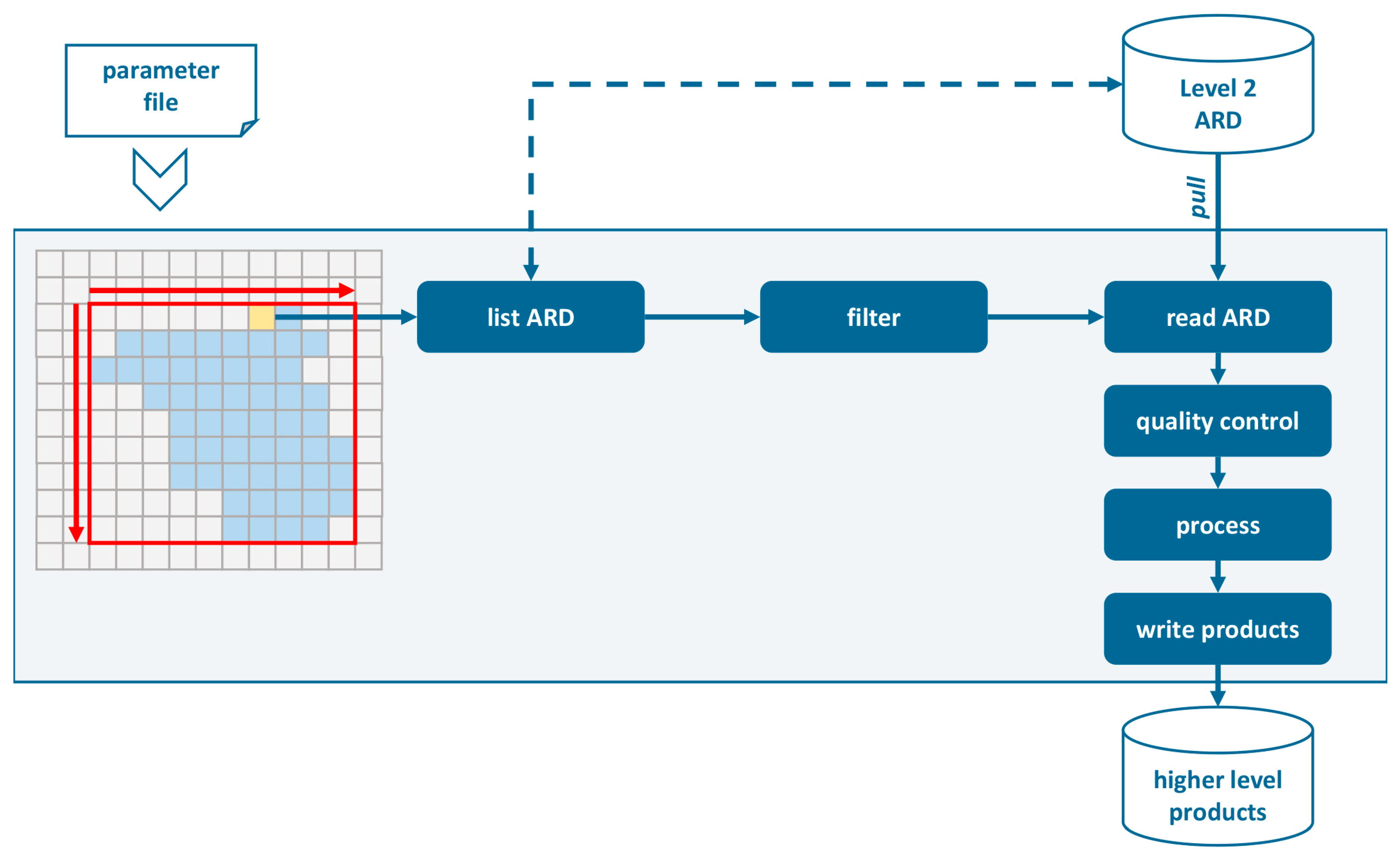
4. Implementation
5. Application
6. Outlook
Funding
Acknowledgments
Conflicts of Interest
References
- Woodcock, C.E.; Allen, R.; Anderson, M.; Belward, A.; Bindschadler, R.; Cohen, W.; Gao, F.; Goward, S.N.; Helder, D.; Helmer, E. Free Access to Landsat Imagery. Science 2008, 320, 1011a. [Google Scholar] [CrossRef]
- Wulder, M.A.; Masek, J.G.; Cohen, W.B.; Loveland, T.R.; Woodcock, C.E. Opening the Archive: How Free Data has Enabled the Science and Monitoring Promise of Landsat. Remote Sens. Environ. 2012, 122, 2–10. [Google Scholar] [CrossRef]
- Wulder, M.A.; Coops, N.C.; Roy, D.P.; White, J.C.; Hermosilla, T. Land cover 2.0. Int. J. Remote Sens. 2018, 39, 4254–4284. [Google Scholar] [CrossRef]
- Zhu, Z.; Wulder, M.A.; Roy, D.P.; Woodcock, C.E.; Hansen, M.C.; Radeloff, V.C.; Healey, S.P.; Schaaf, C.; Hostert, P.; Strobl, P.; et al. Benefits of the free and open Landsat data policy. Remote Sens. Environ. 2019, 224, 382–385. [Google Scholar] [CrossRef]
- Markham, B.L.; Helder, D.L. Forty-Year Calibrated Record of Earth-Reflected Radiance from Landsat: A Review. Remote Sens. Environ. 2012, 122, 30–40. [Google Scholar] [CrossRef]
- Drusch, M.; Del Bello, U.; Carlier, S.; Colin, O.; Fernandez, V.; Gascon, F.; Hoersch, B.; Isola, C.; Laberinti, P.; Martimort, P.; et al. Sentinel-2: ESA’s Optical High-Resolution Mission for GMES Operational Services. Remote Sens. Environ. 2012, 120, 25–36. [Google Scholar] [CrossRef]
- ESA. Sentinel-2 Images the Globe Every 5 Days. Available online: https://earth.esa.int/web/sentinel/missions/sentinel-2/news/-/asset_publisher/Ac0d/content/sentinel-2-images-the-globe-every-5-days (accessed on 18 March 2019).
- Roy, D.P.; Wulder, M.A.; Loveland, T.R.; Woodcock, C.E.; Allen, R.G.; Anderson, M.C.; Helder, D.; Irons, J.R.; Johnson, D.M.; Kennedy, R.; et al. Landsat-8: Science and Product Vision for Terrestrial Global Change Research. Remote Sens. Environ. 2014, 145, 154–172. [Google Scholar] [CrossRef]
- Wulder, M.A.; White, J.C.; Loveland, T.R.; Woodcock, C.E.; Belward, A.S.; Cohen, W.B.; Fosnight, E.A.; Shaw, J.; Masek, J.G.; Roy, D.P. The global Landsat archive: Status, consolidation, and direction. Remote Sens. Environ. 2016, 185, 271–283. [Google Scholar] [CrossRef]
- Pekel, J.-F.; Cottam, A.; Gorelick, N.; Belward, A.S. High-resolution mapping of global surface water and its long-term changes. Nature 2016, 540, 418. [Google Scholar] [CrossRef] [PubMed]
- Pesaresi, M.; Ehrlich, D.; Ferri, S.; Florczyk, A.; Freire, S.; Halkia, M.; Julea, A.; Kemper, T.; Soille, P.; Syrris, V. Operating procedure for the production of the Global Human Settlement Layer from Landsat data of the epochs 1975, 1990, 2000, and 2014. Publ. Off. Eur. Union 2016. [Google Scholar] [CrossRef]
- Gorelick, N.; Hancher, M.; Dixon, M.; Ilyushchenko, S.; Thau, D.; Moore, R. Google Earth Engine: Planetary-scale geospatial analysis for everyone. Remote Sens. Environ. 2017, 202, 18–27. [Google Scholar] [CrossRef]
- Dwyer, J.; Roy, D.; Sauer, B.; Jenkerson, C.; Zhang, H.; Lymburner, L. Analysis Ready Data: Enabling Analysis of the Landsat Archive. Remote Sens. 2018, 10, 1363. [Google Scholar] [CrossRef]
- Claverie, M.; Ju, J.; Masek, J.G.; Dungan, J.L.; Vermote, E.F.; Roger, J.-C.; Skakun, S.V.; Justice, C. The Harmonized Landsat and Sentinel-2 surface reflectance data set. Remote Sens. Environ. 2018, 219, 145–161. [Google Scholar] [CrossRef]
- Asrar, G.; Greenstone, R. (Eds.) MTPE EOS Reference Handbook; NASA/Goddard Space Flight Center: Greenbelt, MD, USA, 1995; p. 281.
- Hansen, M.C.; Loveland, T.R. A Review of Large Area Monitoring of Land Cover Change using Landsat Data. Remote Sens. Environ. 2012, 122, 66–74. [Google Scholar] [CrossRef]
- Frantz, D. Generation of Higher Level Earth Observation Satellite Products for Regional Environmental Monitoring. Ph.D. Thesis, Trier University, Trier, Germany, 2017. [Google Scholar]
- Frantz, D.; Röder, A.; Stellmes, M.; Hill, J. An Operational Radiometric Landsat Preprocessing Framework for Large-Area Time Series Applications. IEEE Trans. Geosci. Remote Sens. 2016, 54, 3928–3943. [Google Scholar] [CrossRef]
- Tange, O. GNU Parallel—The Command-Line Power Tool. USENIX Mag. 2011, 36, 42–47. [Google Scholar]
- Zhu, Z.; Woodcock, C.E. Object-Based Cloud and Cloud Shadow Detection in Landsat Imagery. Remote Sens. Environ. 2012, 118, 83–94. [Google Scholar] [CrossRef]
- Zhu, Z.; Wang, S.; Woodcock, C.E. Improvement and Expansion of the Fmask Algorithm: Cloud, Cloud Shadow, and Snow Detection for Landsats 4–7, 8, and Sentinel 2 Images. Remote Sens. Environ. 2015, 159, 269–277. [Google Scholar] [CrossRef]
- Frantz, D.; Röder, A.; Udelhoven, T.; Schmidt, M. Enhancing the Detectability of Clouds and Their Shadows in Multitemporal Dryland Landsat Imagery: Extending Fmask. IEEE Geosci. Remote Sens. Lett. 2015, 12, 1242–1246. [Google Scholar] [CrossRef]
- Frantz, D.; Haß, E.; Uhl, A.; Stoffels, J.; Hill, J. Improvement of the Fmask algorithm for Sentinel-2 images: Separating clouds from bright surfaces based on parallax effects. Remote Sens. Environ. 2018, 215, 471–481. [Google Scholar] [CrossRef]
- Gao, F.; Masek, J.; Schwaller, M.; Hall, F. On the Blending of the Landsat and MODIS Surface Reflectance: Predicting Daily Landsat Surface Reflectance. IEEE Trans. Geosci. Remote Sens. 2006, 44, 2207–2218. [Google Scholar] [CrossRef]
- Frantz, D.; Stellmes, M.; Röder, A.; Udelhoven, T.; Mader, S.; Hill, J. Improving the Spatial Resolution of Land Surface Phenology by Fusing Medium- and Coarse-Resolution Inputs. IEEE Trans. Geosci. Remote Sens. 2016, 54, 4153–4164. [Google Scholar] [CrossRef]
- Hill, J.; Diemer, C.; Udelhoven, T. A Local Correlation approach for the fusion of image bands with different spatial resolutions. Bull. Soc. Fr. Photogramm. Télédétect. 2003, 169, 26–34. [Google Scholar]
- Tanré, D.; Herman, M.; Deschamps, P.Y.; de Leffe, A. Atmospheric Modeling for Space Measurements of Ground Reflectances, Including Bidirectional Properties. Appl. Opt. 1979, 18, 3587–3594. [Google Scholar] [CrossRef]
- Tanré, D.; Deroo, C.; Duhaut, P.; Herman, M.; Morcrette, J.J.; Perbos, J.; Deschamps, P.Y. Description of a Computer Code to Simulate the Satellite Signal in the Solar Spectrum: The 5S Code. Int. J. Remote Sens. 1990, 11, 659–668. [Google Scholar] [CrossRef]
- Royer, A.; Charbonneau, L.; Teillet, P.M. Interannual Landsat-MSS Reflectance Variation in an Urbanized Temperate Zone. Remote Sens. Environ. 1988, 24, 423–446. [Google Scholar] [CrossRef]
- Hill, J. High Precision Land Cover Mapping and Inventory with Multi-Temporal Earth Observation Satellite Data: The Ardèche Experiment. Ph.D. Thesis, Trier University, Trier, Germany, 1993. [Google Scholar]
- Sobolev, V.V. Light Scattering in Planetary Atmospheres (Translation); Pergamon Press: Oxford, UK; New York, NY, USA, 1975; Volume 76. [Google Scholar]
- Kobayashi, S.; Sanga-Ngoie, K. The Integrated Radiometric Correction of Optical Remote Sensing Imageries. Int. J. Remote Sens. 2008, 29, 5957–5985. [Google Scholar] [CrossRef]
- Bach, H. Die Bestimmung Hydrologischer und Landwirtschaftlicher Oberflächenparameter aus Hyperspektralen Fernerkundungsdaten; Geobuch-Verlag: Munich, Germany, 1995; Volume B 21. [Google Scholar]
- Roy, D.P.; Zhang, H.K.; Ju, J.; Gomez-Dans, J.L.; Lewis, P.E.; Schaaf, C.B.; Sun, Q.; Li, J.; Huang, H.; Kovalskyy, V. A General Method to Normalize Landsat Reflectance Data to Nadir BRDF Adjusted Reflectance. Remote Sens. Environ. 2016, 176, 255–271. [Google Scholar] [CrossRef]
- Roy, D.P.; Li, J.; Zhang, H.K.; Yan, L.; Huang, H.; Li, Z. Examination of Sentinel-2A multi-spectral instrument (MSI) reflectance anisotropy and the suitability of a general method to normalize MSI reflectance to nadir BRDF adjusted reflectance. Remote Sens. Environ. 2017, 199, 25–38. [Google Scholar] [CrossRef]
- Roy, D.; Li, Z.; Zhang, H. Adjustment of Sentinel-2 Multi-Spectral Instrument (MSI) Red-Edge Band Reflectance to Nadir BRDF Adjusted Reflectance (NBAR) and Quantification of Red-Edge Band BRDF Effects. Remote Sens. 2017, 9, 1325. [Google Scholar] [CrossRef]
- Yin, H.; Tan, B.; Frantz, D.; Buchner, J.; Radeloff, V. Evaluation of topographic correction on forest mapping using Landsat imagery. (under review).
- Doxani, G.; Vermote, E.; Roger, J.-C.; Gascon, F.; Adriaensen, S.; Frantz, D.; Hagolle, O.; Hollstein, A.; Kirches, G.; Li, F.; et al. Atmospheric Correction Inter-Comparison Exercise. Remote Sens. 2018, 10, 352. [Google Scholar] [CrossRef]
- Baetens, L.; Desjardins, C.; Hagolle, O. Validation of Copernicus Sentinel-2 Cloud Masks Obtained from MAJA, Sen2Cor, and FMask Processors Using Reference Cloud Masks Generated with a Supervised Active Learning Procedure. Remote Sens. 2019, 11, 433. [Google Scholar] [CrossRef]
- Frantz, D.; Stellmes, M. Water vapor database for atmospheric correction of Landsat imagery. PANGAEA 2018. [Google Scholar] [CrossRef]
- Frantz, D.; Stellmes, M.; Hostert, P. A Global MODIS Water Vapor Database for the Operational Atmospheric Correction of Historic and Recent Landsat Imagery. Remote Sens. 2019, 11, 257. [Google Scholar] [CrossRef]
- Frantz, D. FORCE v. 2.0—Technical User Guide; ResearchGate: Berlin, Germany, 2018. [Google Scholar] [CrossRef]
- Ernst, S.; Lymburner, L.; Sixsmith, J. Implications of Pixel Quality Flags on the Observation Density of a Continental Landsat Archive. Remote Sens. 2018, 10, 1570. [Google Scholar] [CrossRef]
- Haß, E.; Frantz, D.; Mader, S.; Hill, J. Global Analysis of the Differences between the MODIS Vegetation Index Compositing Date and the Actual Acquisition Date. IEEE Geosci. Remote Sens. Lett. 2017, 14, 866–870. [Google Scholar] [CrossRef]
- Griffiths, P.; van der Linden, S.; Kuemmerle, T.; Hostert, P. A Pixel-Based Landsat Compositing Algorithm for Large Area Land Cover Mapping. IEEE J. Sel. Top. Appl. Earth Observ. Remote Sens. 2013, 6, 2088–2101. [Google Scholar] [CrossRef]
- Müller, H.; Rufin, P.; Griffiths, P.; Barros Siqueira, A.J.; Hostert, P. Mining dense Landsat time series for separating cropland and pasture in a heterogeneous Brazilian savanna landscape. Remote Sens. Environ. 2015, 156, 490–499. [Google Scholar] [CrossRef]
- Frantz, D.; Röder, A.; Stellmes, M.; Hill, J. Phenology-adaptive pixel-based compositing using optical earth observation imagery. Remote Sens. Environ. 2017, 190, 331–347. [Google Scholar] [CrossRef]
- Smith, M.O.; Ustin, S.L.; Adams, J.B.; Gillespie, A.R. Vegetation in deserts: I. A regional measure of abundance from multispectral images. Remote Sens. Environ. 1990, 31, 1–26. [Google Scholar] [CrossRef]
- Schwieder, M.; Leitão, P.J.; da Cunha Bustamante, M.M.; Ferreira, L.G.; Rabe, A.; Hostert, P. Mapping Brazilian savanna vegetation gradients with Landsat time series. Int. J. Appl. Earth Obs. Geoinf. 2016, 52, 361–370. [Google Scholar] [CrossRef]
- Schneibel, A.; Frantz, D.; Röder, A.; Stellmes, M.; Fischer, K.; Hill, J. Using Annual Landsat Time Series for the Detection of Dry Forest Degradation Processes in South-Central Angola. Remote Sens. 2017, 9, 905. [Google Scholar] [CrossRef]
- Melaas, E.K.; Friedl, M.A.; Zhu, Z. Detecting Interannual Variation in Deciduous Broadleaf Forest Phenology using Landsat TM/ETM+ Data. Remote Sens. Environ. 2013, 132, 176–185. [Google Scholar] [CrossRef]
- Mader, S. A Framework for the Phenological Analysis of Hypertemporal Remote Sensing Data Based on Polynomial Spline Models. Ph.D. Thesis, Trier University, Trier, Germany, 2012. [Google Scholar]
- Hostert, P.; Röder, A.; Hill, J. Coupling Spectral Unmixing and Trend Analysis for Monitoring of Long-Term Vegetation Dynamics in Mediterranean Rangelands. Remote Sens. Environ. 2003, 87, 183–197. [Google Scholar] [CrossRef]
- Sonnenschein, R.; Kuemmerle, T.; Udelhoven, T.; Stellmes, M.; Hostert, P. Differences in Landsat-Based Trend Analyses in Drylands due to the Choice of Vegetation Estimate. Remote Sens. Environ. 2011, 115, 1408–1420. [Google Scholar] [CrossRef]
- Hird, J.N.; Castilla, G.; McDermid, G.J.; Bueno, I.T. A Simple Transformation for Visualizing Non-seasonal Landscape Change from Dense Time Series of Satellite Data. IEEE J. Sel. Top. Appl. Earth Observ. Remote Sens. 2016, 9, 3372–3383. [Google Scholar] [CrossRef]
- Frantz, D. FORCE—Framework for Operational Radiometric Correction for Environmental Monitoring. v. 2.1. 2018. Available online: http://force.feut.de (accessed on 9 May 2019).
- GDAL. GDAL—Geospatial Data Abstraction Library; 2.2.2; Open Source Geospatial Foundation: Chicago, IL, USA, 2017; Available online: http://www.gdal.org (accessed on 9 May 2019).
- GSL. GSL—GNU Scientific Library; 1.2; Free Software Foundation: Boston, MA, USA, 2015; Available online: https://www.gnu.org/software/gsl/ (accessed on 9 May 2019).
- OpenMP. OpenMP—The OpenMP API Specification for Parallel Programming. 4.0. 2016. Available online: https://www.openmp.org/ (accessed on 9 May 2019).
- curl. curl—Command Line Tool and Library for Transferring Data with URLs. 7.47.0. 2016. Available online: https://curl.haxx.se/ (accessed on 9 May 2019).
- Mader, S. SPLITS—Spline Analysis of Time Series. v. 1.9. 2018. Available online: http://sebastian-mader.net/splits (accessed on 9 May 2019).
- Röder, A.; Stellmes, M.; Frantz, D.; Hill, J. Remote sensing-based environmental assessment and monitoring—generation of operational baseline and enhanced experimental products in southern Africa. In Biodiversity & Ecology 6—Climate Change and Adaptive Landmanagement in Southern Africa—Assessments, Changes, Challenges, and Solutions; Revermann, R., Krewenka, K.M., Schmiedel, U., Olwoch, J.M., Helmschrot, J., Jürgens, N., Eds.; University of Hamburg: Hamburg, Germany, 2018; pp. 344–354. [Google Scholar] [CrossRef]
- Schneibel, A.; Stellmes, M.; Röder, A.; Finckh, M.; Revermann, R.; Frantz, D.; Hill, J. Evaluating the Trade-Off between Food and Timber Resulting from the Conversion of Miombo Forests to Agricultural Land in Angola Using Multi-Temporal Landsat Data. Sci. Total Environ. 2016, 548–549, 390–401. [Google Scholar] [CrossRef]
- Schneibel, A.; Stellmes, M.; Röder, A.; Frantz, D.; Kowalski, B.; Haß, E.; Hill, J. Assessment of spatio-temporal changes of smallholder cultivation patterns in the Angolan Miombo belt using segmentation of Landsat time series. Remote Sens. Environ. 2017, 195, 118–129. [Google Scholar] [CrossRef]
- Parduhn, D.; Frantz, D. Seeing deforestation in Zambia—On the discrepancy between biophysical land-use changes and social perception. In Biodiversity & Ecology 6—Climate Change and Adaptive Landmanagement in Southern AFRICA—Assessments, Changes, Challenges, and Solutions; Revermann, R., Krewenka, K.M., Schmiedel, U., Olwoch, J.M., Helmschrot, J., Jürgens, N., Eds.; University of Hamburg: Hamburg, Germany, 2018; pp. 317–323. [Google Scholar] [CrossRef]
- Rufin, P.; Frantz, D.; Ernst, S.; Rabe, A.; Griffiths, P.; Özdoğan, M.; Hostert, P. Mapping Cropping Practices on a National Scale Using Intra-Annual Landsat Time Series Binning. Remote Sens. 2019, 11, 232. [Google Scholar] [CrossRef]
- Frantz, D.; Hostert, P.; Pflugmacher, D.; van der Linden, S.; Baumann, M.; Kümmerle, T.; Röder, A.; Griffiths, P. Land Use 2.0: The role of dense time series and phenometrics. In Proceedings of the Landsat Science Team Meeting, Boulder, CO, USA, 8–10 August 2018. [Google Scholar]
- Radeloff, V.; Yin, H.; Tan, B.; Frantz, D.; Buchner, J. Topographic Correction of Landsat imagery in the Caucasus Mountains. In Proceedings of the Landsat Science Team Meeting, Boulder, CO, USA, 8–10 August 2018. [Google Scholar]
- Hill, J.; Mader, S.; Frantz, D.; Stoffels, J.; Langshausen, J.; Dietz, J.; Averdung, C.; Göpfert, J. Sentinel4GRIPS: Copernicus als Baustein der Forstverwaltung. In Proceedings of the Nationales Forum für Fernerkundung und Copernicus, Berlin, Germany, 27–29 November 2018. [Google Scholar]
- Gascon, F.; Bouzinac, C.; Thépaut, O.; Jung, M.; Francesconi, B.; Louis, J.; Lonjou, V.; Lafrance, B.; Massera, S.; Gaudel-Vacaresse, A.; et al. Copernicus Sentinel-2A Calibration and Products Validation Status. Remote Sens. 2017, 9, 584. [Google Scholar] [CrossRef]
- Yan, L.; Roy, D.P.; Zhang, H.; Li, J.; Huang, H. An Automated Approach for Sub-Pixel Registration of Landsat-8 Operational Land Imager (OLI) and Sentinel-2 Multi Spectral Instrument (MSI) Imagery. Remote Sens. 2016, 8, 520. [Google Scholar] [CrossRef]
- ESA. CEOS-WGCV ACIX II—CMIX: Atmospheric Correction Inter-Comparison Exercise—Cloud Masking Inter-Comparison Exercise. Available online: https://earth.esa.int/web/sppa/meetings-workshops/acix (accessed on 18 March 2019).
- Poursanidis, D.; Traganos, D.; Reinartz, P.; Chrysoulakis, N. On the use of Sentinel-2 for coastal habitat mapping and satellite-derived bathymetry estimation using downscaled coastal aerosol band. Int. J. Appl. Earth Obs. Geoinf. 2019, 80, 58–70. [Google Scholar] [CrossRef]
- Jakimow, B. EO Time Series Viewer. v. 0.7.20181113T2117.develop. 2018. Available online: https://plugins.qgis.org/plugins/timeseriesviewerplugin/ (accessed on 9 May 2019).
- Rabe, A. Raster Timeseries Manager. v. 1.4. 2019. Available online: https://plugins.qgis.org/plugins/rastertimeseriesmanager/ (accessed on 9 May 2019).
- Rabe, A. Raster Data Plotting. v. 1.3. 2019. Available online: https://plugins.qgis.org/plugins/rasterdataplotting/ (accessed on 9 May 2019).


| Wavelength Designation | FORCE Level 2 Band LND0 [4,5,6,7,8] | FORCE Level 2 Band SEN2[AB] | USGS Level 1 Band Landsat 4/5/7 | USGS Level 1 Band Landsat 8 | ESA Level 1 Band Sentinel-2 A/B |
|---|---|---|---|---|---|
| BLUE | 1 | 1 | 1 | 2 | 2 |
| GREEN | 2 | 2 | 2 | 3 | 3 |
| RED | 3 | 3 | 3 | 4 | 4 |
| REDEDGE1 | - | 4 | - | - | 5 |
| REDEDGE2 | - | 5 | - | - | 6 |
| REDEDGE3 | - | 6 | - | - | 7 |
| BROADNIR | - | 7 | - | - | 8 |
| NIR | 4 | 8 | 4 | 5 | 8A |
| SWIR1 | 5 | 9 | 5 | 6 | 11 |
| SWIR2 | 6 | 10 | 7 | 7 | 12 |
| Bit No. | Parameter Name | Bit Comb. | Integer | State |
|---|---|---|---|---|
| 0 | Valid data | 0 | 0 | valid |
| 1 | 1 | no data | ||
| 1–2 | Cloud state | 00 | 0 | clear |
| 01 | 1 | less confident cloud (i.e., buffered cloud 300 m) | ||
| 10 | 2 | confident, opaque cloud | ||
| 11 | 3 | cirrus | ||
| 3 | Cloud shadow flag | 0 | 0 | no |
| 1 | 1 | yes | ||
| 4 | Snow flag | 0 | 0 | no |
| 1 | 1 | yes | ||
| 5 | Water flag | 0 | 0 | no |
| 1 | 1 | yes | ||
| 6–7 | Aerosol state | 00 | 0 | estimated (best quality) |
| 01 | 1 | interpolated (mid quality) | ||
| 10 | 2 | high (aerosol optical depth > 0.6, use with caution) | ||
| 11 | 3 | fill (global fallback, low quality) | ||
| 8 | Subzero flag | 0 | 0 | no |
| 1 | 1 | yes (use with caution) | ||
| 9 | Saturation flag | 0 | 0 | no |
| 1 | 1 | yes (use with caution) | ||
| 10 | High sun zenith flag | 0 | 0 | no |
| 1 | 1 | yes (sun elevation < 15°, use with caution) | ||
| 11–12 | Illumination state | 00 | 0 | good (incidence angle < 55°, best quality for top. correction) |
| 01 | 1 | medium (incidence angle 55°–80°, good quality for top. correction) | ||
| 10 | 2 | poor (incidence angle > 80°, low quality for top. correction) | ||
| 11 | 3 | shadow (incidence angle > 90°, no top. correction applied) | ||
| 13 | Slope flag | 0 | 0 | no (cosine correction applied) |
| 1 | 1 | yes (enhanced C-correction applied) | ||
| 14 | Water vapor flag | 0 | 0 | measured (best quality, only Sentinel-2) |
| 1 | 1 | fill (scene average, only Sentinel-2) | ||
| 15 | Empty | 0 | 0 | TBD |
© 2019 by the author. Licensee MDPI, Basel, Switzerland. This article is an open access article distributed under the terms and conditions of the Creative Commons Attribution (CC BY) license (http://creativecommons.org/licenses/by/4.0/).
Share and Cite
Frantz, D. FORCE—Landsat + Sentinel-2 Analysis Ready Data and Beyond. Remote Sens. 2019, 11, 1124. https://doi.org/10.3390/rs11091124
Frantz D. FORCE—Landsat + Sentinel-2 Analysis Ready Data and Beyond. Remote Sensing. 2019; 11(9):1124. https://doi.org/10.3390/rs11091124
Chicago/Turabian StyleFrantz, David. 2019. "FORCE—Landsat + Sentinel-2 Analysis Ready Data and Beyond" Remote Sensing 11, no. 9: 1124. https://doi.org/10.3390/rs11091124
APA StyleFrantz, D. (2019). FORCE—Landsat + Sentinel-2 Analysis Ready Data and Beyond. Remote Sensing, 11(9), 1124. https://doi.org/10.3390/rs11091124