High Spatial Resolution Remote Sensing for Salt Marsh Mapping and Change Analysis at Fire Island National Seashore

Abstract
1. Introduction
2. Materials and Methods
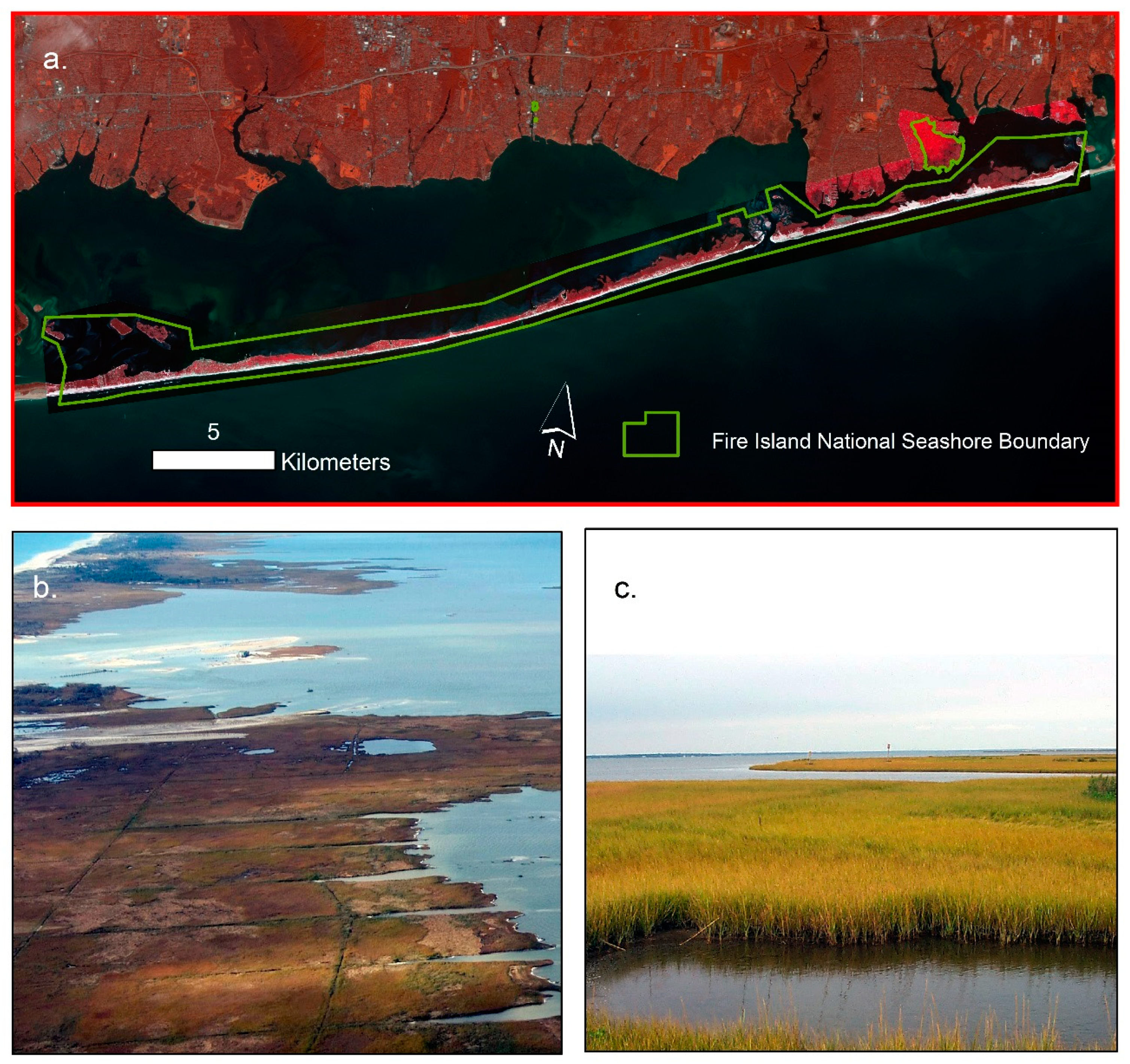
2.1. Study Area
2.2. Data
2.3. Tidal Stage Effects
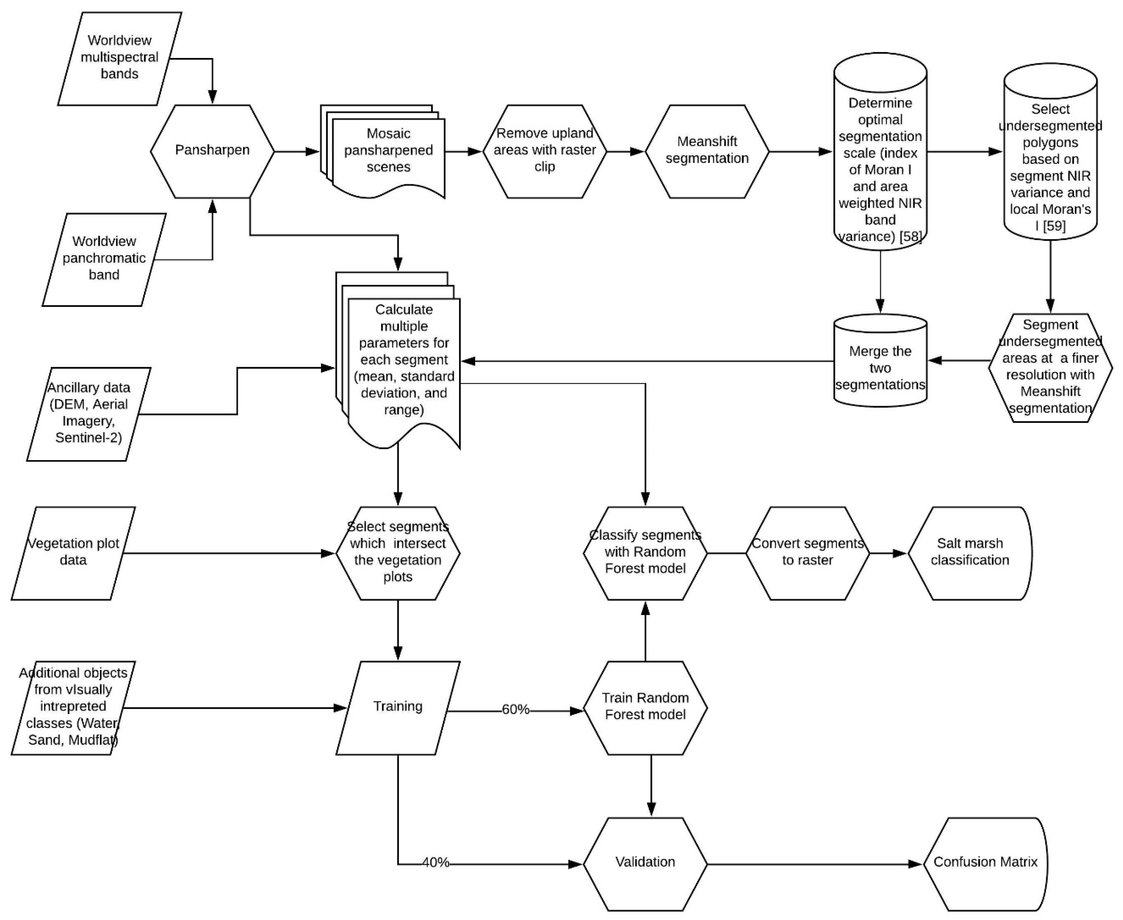
2.4. Object-Based Image Analysis
2.5. Change Analysis (1994–2017)
2.6. Statistical Analysis
3. Results
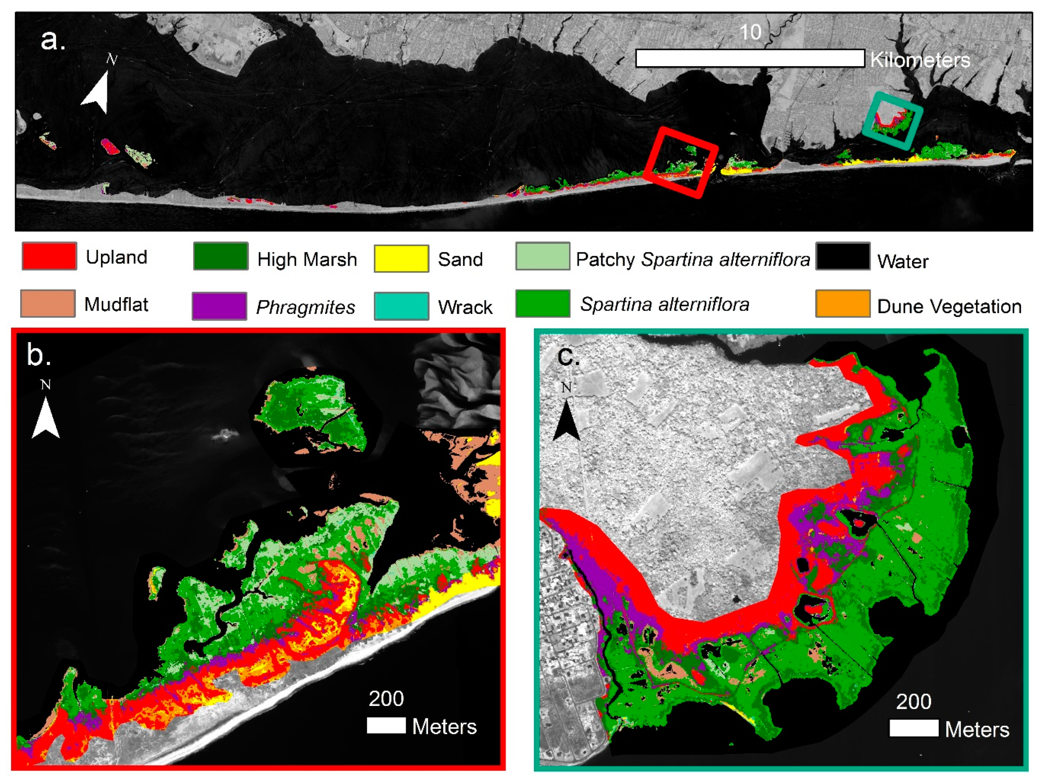
3.1. OBIA Classification
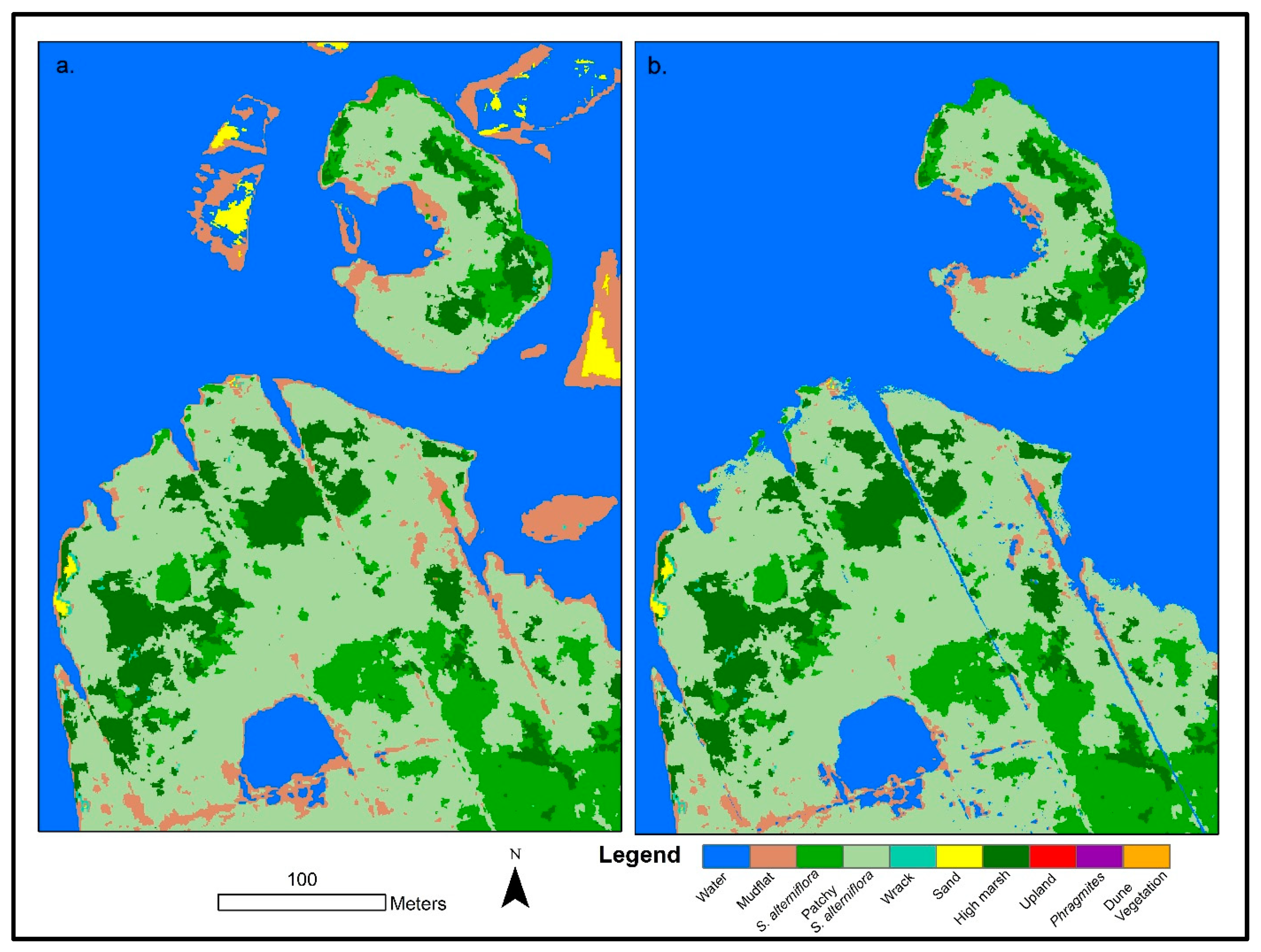
3.2. Tidal Stage Effect
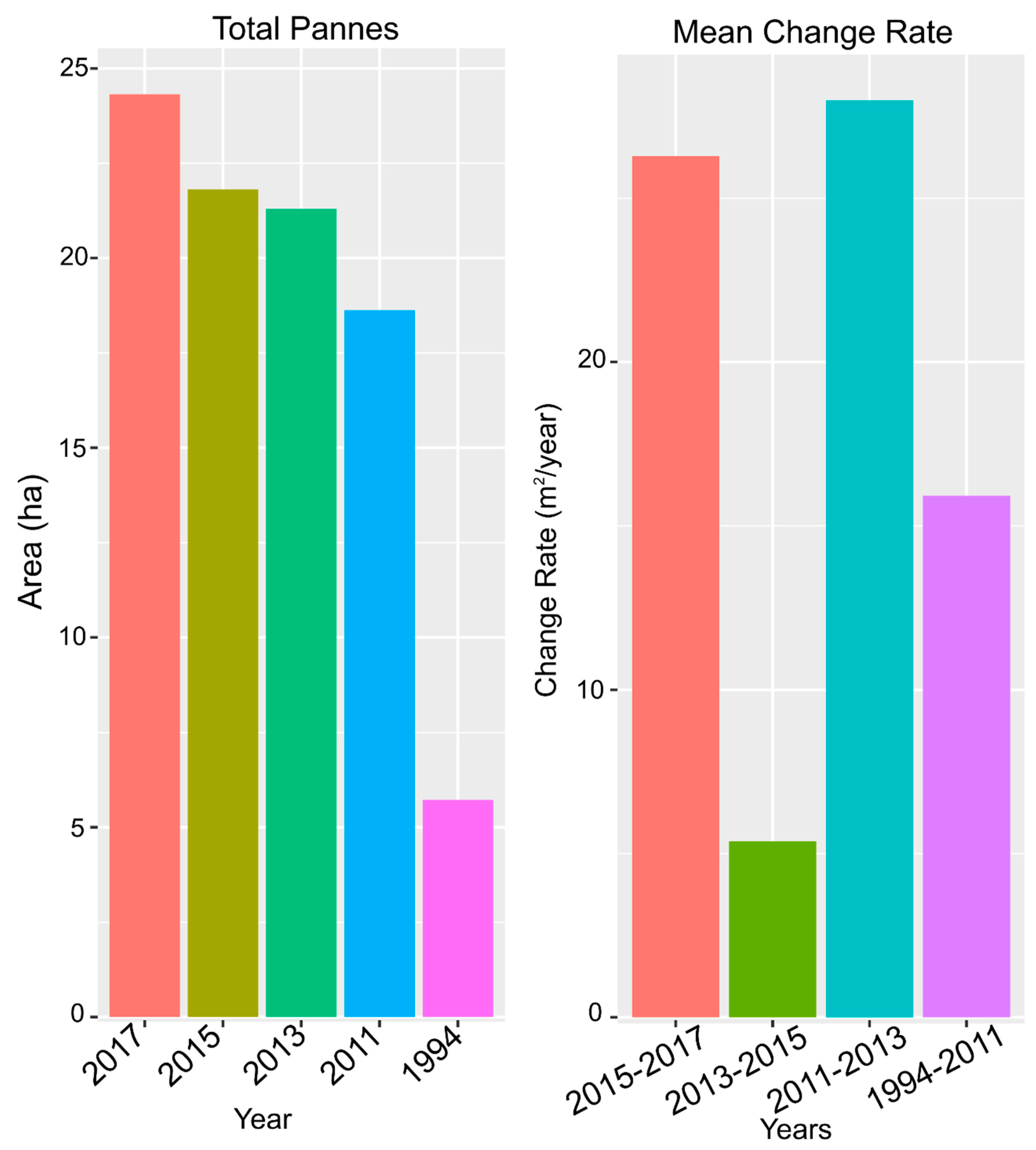
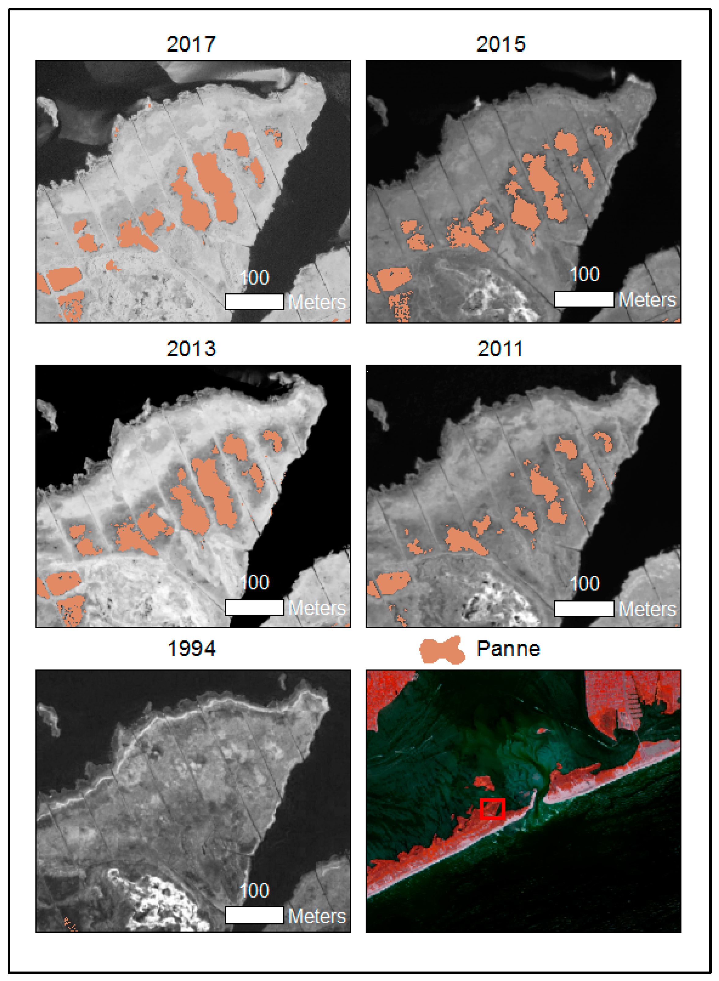
3.3. Change Analysis (1994–2017)
4. Discussion
5. Conclusions
Author Contributions
Funding
Acknowledgments
Conflicts of Interest
References
- Zedler, J.B.; Kercher, S. Wetland Resources: Status, Trends, Ecosystem Services, and Restorability. Annu. Rev. Environ. Resour. 2005, 30, 39–74. [Google Scholar] [CrossRef]
- Barbier, E.B.; Hacker, S.D.; Kennedy, C.; Koch, E.W.; Stier, A.C.; Silliman, B.R. The Value of Estuarine and Coastal Ecosystem Services. Ecol. Monogr. 2011, 81, 169–193. [Google Scholar] [CrossRef]
- Gedan, K.B.; Silliman, B.R.; Bertness, M.D. Centuries of Human-Driven Change in Salt Marsh Ecosystems. Annu. Rev. Mar. Sci. 2009, 1, 117–141. [Google Scholar] [CrossRef] [PubMed]
- Crain, C.M.; Gedan, K.B.; Dionne, M. Tidal Restrictions and Mosquito Ditching in New England Marshes. In Human Impacts on Salt Marshes: A Global Perspective; University of California Press: Berkeley, CA, USA, 2009; pp. 149–169. [Google Scholar]
- Crosby, S.C.; Sax, D.F.; Palmer, M.E.; Booth, H.S.; Deegan, L.A.; Bertness, M.D.; Leslie, H.M. Salt Marsh Persistence is Threatened by Predicted Sea-Level Rise. Estuar. Coast. Shelf Sci. 2016, 181, 93–99. [Google Scholar] [CrossRef]
- Watson, E.B.; Raposa, K.B.; Carey, J.C.; Wigand, C.; Warren, R.S. Anthropocene Survival of Southern New England’s Salt Marshes. Estuaries Coasts 2017, 40, 617–625. [Google Scholar] [CrossRef] [PubMed]
- Wigand, C.; Roman, C.T.; Davey, E.; Stolt, M.; Johnson, R.; Hanson, A.; Watson, E.B.; Moran, S.B.; Cahoon, D.R.; Lynch, J.C. Below the Disappearing Marshes of an Urban Estuary: Historic Nitrogen Trends and Soil Structure. Ecol. Appl. 2014, 24, 633–649. [Google Scholar] [CrossRef] [PubMed]
- Altieri, A.H.; Bertness, M.D.; Coverdale, T.C.; Herrmann, N.C.; Angelini, C. A Trophic Cascade Triggers Collapse of a Salt-marsh Ecosystem with Intensive Recreational Fishing. Ecology 2012, 93, 1402–1410. [Google Scholar] [CrossRef]
- Deegan, L.A.; Johnson, D.S.; Warren, R.S.; Peterson, B.J.; Fleeger, J.W.; Fagherazzi, S.; Wollheim, W.M. Coastal Eutrophication as a Driver of Salt Marsh Loss. Nature 2012, 490, 388–392. [Google Scholar] [CrossRef]
- Kirwan, M.L.; Guntenspergen, G.R. Influence of Tidal Range on the Stability of Coastal Marshland. J. Geophys. Res. Earth Surf. 2010, 115. [Google Scholar] [CrossRef]
- Kirwan, M.L.; Murray, A.B.; Boyd, W.S. Temporary Vegetation Disturbance as an Explanation for Permanent Loss of Tidal Wetlands. Geophys. Res. Lett. 2008, 35. [Google Scholar] [CrossRef]
- Holdredge, C.; Bertness, M.D.; Altieri, A.H. Role of Crab Herbivory in Die-Off of New England Salt Marshes. Conserv. Biol. 2009, 23, 672–679. [Google Scholar] [CrossRef]
- Kearney, M.S.; Rogers, A.S.; Townshend, J.R.; Rizzo, E.; Stutzer, D.; Stevenson, J.C.; Sundborg, K. Landsat Imagery shows Decline of Coastal Marshes in Chesapeake and Delaware Bays. EOS Trans. Am. Geophys. Union 2002, 83, 173–178. [Google Scholar] [CrossRef]
- Schepers, L.; Kirwan, M.; Guntenspergen, G.; Temmerman, S. Spatio-temporal Development of Vegetation Die-off in a Submerging Coastal Marsh. Limnol. Oceanogr. 2017, 62, 137–150. [Google Scholar] [CrossRef]
- Cameron Engineering and Associates. Long Island Tidal Wetlands Trends Analysis; New England Interstate Water Pollution Control Commission: Lowell, MA, USA, 2015; 207p. [Google Scholar]
- Watson, E.B.; Wigand, C.; Davey, E.W.; Andrews, H.M.; Bishop, J.; Raposa, K.B. Wetland Loss Patterns and Inundation-Productivity Relationships Prognosticate Widespread Salt Marsh Loss for Southern New England. Estuaries Coasts 2017, 40, 662–681. [Google Scholar] [CrossRef]
- Schieder, N.W.; Walters, D.C.; Kirwan, M.L. Massive Upland to Wetland Conversion Compensated for Historical Marsh Loss in Chesapeake Bay, USA. Estuaries Coasts 2018, 41, 940–951. [Google Scholar] [CrossRef]
- Schuerch, M.; Spencer, T.; Temmerman, S.; Kirwan, M.L.; Wolff, C.; Lincke, D.; McOwen, C.J.; Pickering, M.D.; Reef, R.; Vafeidis, A.T. Future Response of Global Coastal Wetlands to Sea-Level Rise. Nature 2018, 561, 231. [Google Scholar] [CrossRef]
- Marsh, A.; Blum, L.K.; Christian, R.R.; Ramsey, E.; Rangoonwala, A. Response and Resilience of Spartina Alterniflora. J. Coast. Conserv. 2016, 20, 335–350. [Google Scholar] [CrossRef]
- Alber, M.; Swenson, E.M.; Adamowicz, S.C.; Mendelssohn, I.A. Salt Marsh Dieback: An Overview of Recent Events in the US. Estuar. Coast. Shelf Sci. 2008, 80, 1–11. [Google Scholar] [CrossRef]
- Kearney, M.S.; Turner, R.E. Microtidal Marshes: Can these Widespread and Fragile Marshes Survive Increasing Climate–sea Level Variability and Human Action? J. Coast. Res. 2016, 32, 686–699. [Google Scholar] [CrossRef]
- Wilson, K.R.; Kelley, J.T.; Croitoru, A.; Dionne, M.; Belknap, D.F.; Steneck, R. Stratigraphic and Ecophysical Characterizations of Salt Pools: Dynamic Landforms of the Webhannet Salt Marsh, Wells, ME, USA. Estuaries Coasts 2009, 32, 855–870. [Google Scholar] [CrossRef]
- Cowardin, L.M.; Carter, V.; Golet, F.C.; LaRoe, E.T. Classification of Wetlands and Deepwater Habitats of the United States; U.S. Department of the Interior: Washington, DC, USA, 1979; 131p.
- Wilson, C.A.; Hughes, Z.J.; FitzGerald, D.M.; Hopkinson, C.S.; Valentine, V.; Kolker, A.S. Saltmarsh Pool and Tidal Creek Morphodynamics: Dynamic Equilibrium of Northern Latitude Saltmarshes? Geomorphology 2014, 213, 99–115. [Google Scholar] [CrossRef]
- Mariotti, G. Revisiting Salt Marsh Resilience to Sea Level Rise: Are Ponds Responsible for Permanent Land Loss? J. Geophys. Res. Earth Surf. 2016, 121, 1391–1407. [Google Scholar] [CrossRef]
- Hapke, C.J.; Brenner, O.; Hehre, R.; Reynolds, B.J. Coastal Change from Hurricane Sandy and the 2012–13 Winter Storm Season—Fire Island; Geological Survey Open-File Report; U.S. Geological Survey: Reston, VA, USA, 2013.
- Leatherman, S.P. Geomorphic and Stratigraphic Analysis of Fire Island, New York. Mar. Geol. 1985, 63, 173–195. [Google Scholar] [CrossRef]
- Friedrichs, C.T.; Perry, J.E. Tidal Salt Marsh Morphodynamics: A Synthesis. J. Coast. Res. 2001, 7–37. Available online: https://www.jstor.org/stable/25736162 (accessed on 15 January 2019).
- Courtemanche, R.P., Jr.; Hester, M.W.; Mendelssohn, I.A. Recovery of a Louisiana Barrier Island Marsh Plant Community Following Extensive Hurricane-Induced Overwash. J. Coast. Res. 1999, 15, 872–883. [Google Scholar]
- Roman, C.T.; King, D.R.; Cahoon, D.R.; Lynch, J.C.; Appleby, P.G. Evaluation of Marsh Development Processes at Fire Island National Seashore: Recent and Historic Perspectives; National Park Service: Boston, MA, USA, 2007.
- Silvestri, S.; D’Alpaos, A.; Nordio, G.; Carniello, L. Anthropogenic Modifications can significantly Influence the Local Mean Sea Level and Affect the Survival of Salt Marshes in Shallow Tidal Systems. J. Geophys. Res. Earth Surf. 2018, 123, 996–1012. [Google Scholar]
- Adamowicz, S.C.; Roman, C.T. New England Salt Marsh Pools: A Quantitative Analysis of Geomorphic and Geographic Features. Wetlands 2005, 25, 279–288. [Google Scholar] [CrossRef]
- Millette, T.L.; Argow, B.A.; Marcano, E.; Hayward, C.; Hopkinson, C.S.; Valentine, V. Salt Marsh Geomorphological Analyses Via Integration of Multitemporal Multispectral Remote Sensing with LIDAR and GIS. J. Coast. Res. 2010, 26, 809–816. [Google Scholar] [CrossRef]
- Smith, S.M. Vegetation Change in Salt Marshes of Cape Cod National Seashore (Massachusetts, USA) between 1984 and 2013. Wetlands 2015, 35, 127–136. [Google Scholar] [CrossRef]
- Campbell, A.; Wang, Y.; Christiano, M.; Stevens, S. Salt Marsh Monitoring in Jamaica Bay, New York from 2003 to 2013: A Decade of Change from Restoration to Hurricane Sandy. Remote Sens. 2017, 9, 131. [Google Scholar] [CrossRef]
- Sun, C.; Fagherazzi, S.; Liu, Y. Classification Mapping of Salt Marsh Vegetation by Flexible Monthly NDVI Time-Series using Landsat Imagery. Estuar. Coast. Shelf Sci. 2018, 213, 61–80. [Google Scholar] [CrossRef]
- McElroy, A.; Benotti, M.; Edinger, G.; Feldmann, A.; O’Connell, C.; Steward, G.; Swanson, R.L.; Waldman, J. Assessment of Natural Resource Conditions: Fire Island National Seashore; Natural Resource Report NPS/NRPC/NRR; National Park Service: Fort Collins, CO, USA, 2009.
- Hair, M.E.; Buckner, S. An Assessment of the Water Quality Characteristics of Great South Bay and Contiguous Streams; Adelphi University Institute of Marine Science: Garden City, NY, USA, 1973. [Google Scholar]
- Lentz, E.E.; Hapke, C.J. Geologic Framework Influences on the Geomorphology of an Anthropogenically Modified Barrier Island: Assessment of Dune/Beach Changes at Fire Island, New York. Geomorphology 2011, 126, 82–96. [Google Scholar] [CrossRef]
- Leonardi, N.; Ganju, N.K.; Fagherazzi, S. A Linear Relationship between Wave Power and Erosion Determines Salt-Marsh Resilience to Violent Storms and Hurricanes. Proc. Natl. Acad. Sci. USA 2016, 113, 64–68. [Google Scholar] [CrossRef]
- Aerts, J.C.; Lin, N.; Botzen, W.; Emanuel, K.; de Moel, H. Low-Probability Flood Risk Modeling for New York City. Risk Anal. 2013, 33, 772–788. [Google Scholar] [CrossRef]
- Wang, Y.; Traber, M.; Milstead, B.; Stevens, S. Terrestrial and Submerged Aquatic Vegetation Mapping in Fire Island National Seashore using High Spatial Resolution Remote Sensing Data. Mar. Geod. 2007, 30, 77–95. [Google Scholar] [CrossRef]
- U.S. Geological Survey (USGS). USGS Surface-Water Daily Data for New York. Watch Hill, NY, USA, 2017. Available online: https://waterdata.usgs.gov/ny/nwis/uv?site_no=01305575 (accessed on 15 January 2019).
- Morgan, K.L.M.; Krohn, M.D. Post-Hurricane Sandy Coastal Oblique Aerial Photographs Collected from Cape Lookout, North Carolina, to Montauk, New York, November 4–6, 2012; U.S. Geological Survey Data Series 858; U.S. Geological Survey: Reston, VA, USA, 2014. [CrossRef]
- Conservation Management Institute, NatureServe, and New York Natural Heritage Program. Fire Island National Seashore Vegetation Inventory Project—Spatial Vegetation Data; National Park Service: Denver, CO, USA, 2002. Available online: https://www.sciencebase.gov/catalog/item/541ca909e4b0e96537e0a41e (accessed on 15 January 2019).
- Klopfer, S.D.; Olivero, A.; Sneddon, L.; Lundgren, J. Final Report of the NPS Vegetation Mapping Project at Fire Island National Seashore; Conservation Management Institute—Virginia Tech: Blacksburg, VA, USA, 2002. [Google Scholar]
- U.S. Geological Survey (USGS). USGS Surface-Water Daily Data for New York. Lindenhurst, NY, USA, 2017. Available online: https://waterdata.usgs.gov/ny/nwis/uv?site_no=01309225 (accessed on 15 January 2019).
- Jensen, J.R.; Cowen, D.J.; Althausen, J.D.; Narumalani, S.; Weatherbee, O. The Detection and Prediction of Sea Level Changes on Coastal Wetlands using Satellite Imagery and a Geographic Information System. Geocarto Int. 1993, 8, 87–98. [Google Scholar] [CrossRef]
- Jensen, J.R.; Cowen, D.J.; Althausen, J.D.; Narumalani, S.; Weatherbee, O. An Evaluation of the CoastWatch Change Detection Protocol in South Carolina. Photogramm. Eng. Remote Sens. 1993, 59, 1039–1044. [Google Scholar]
- Campbell, A.; Wang, Y. Examining the Influence of Tidal Stage on Salt Marsh Mapping using High-Spatial-Resolution Satellite Remote Sensing and Topobathymetric Lidar. IEEE Trans. Geosci. Remote Sens. 2018, 56, 5169–5176. [Google Scholar] [CrossRef]
- Hay, G.J.; Castilla, G. Geographic Object-Based Image Analysis (GEOBIA): A new name for a new discipline. In Object-Based Image Analysis; Blaschke, T., Lang, S., Hay, G.J., Eds.; Springer: Berlin, Germany, 2008; pp. 75–89. [Google Scholar]
- Bo, S.; Ding, L.; Li, H.; Di, F.; Zhu, C. Mean Shift-based Clustering Analysis of Multispectral Remote Sensing Imagery. Int. J. Remote Sens. 2009, 30, 817–827. [Google Scholar] [CrossRef]
- Yang, G.; Pu, R.; Zhang, J.; Zhao, C.; Feng, H.; Wang, J. Remote Sensing of Seasonal Variability of Fractional Vegetation Cover and its Object-Based Spatial Pattern Analysis Over Mountain Areas. ISPRS J. Photogramm. Remote Sens. 2013, 77, 79–93. [Google Scholar] [CrossRef]
- Castillejo-González, I.L.; López-Granados, F.; García-Ferrer, A.; Peña-Barragán, J.M.; Jurado-Expósito, M.; de la Orden, M.S.; González-Audicana, M. Object- and Pixel-Based Analysis for Mapping Crops and their Agro-Environmental Associated Measures using QuickBird Imagery. Comput. Electron. Agric. 2009, 68, 207–215. [Google Scholar] [CrossRef]
- Myint, S.W.; Gober, P.; Brazel, A.; Grossman-Clarke, S.; Weng, Q. Per-Pixel vs. Object-Based Classification of Urban Land Cover Extraction using High Spatial Resolution Imagery. Remote Sens. Environ. 2011, 115, 1145–1161. [Google Scholar] [CrossRef]
- Lantz, N.J.; Wang, J. Object-Based Classification of Worldview-2 Imagery for Mapping Invasive Common Reed, Phragmites Australis. Can. J. Remote Sens. 2013, 39, 328–340. [Google Scholar] [CrossRef]
- Espindola, G.M.; Câmara, G.; Reis, I.A.; Bins, L.S.; Monteiro, A.M. Parameter Selection for Region-growing Image Segmentation Algorithms using Spatial Autocorrelation. Int. J. Remote Sens. 2006, 27, 3035–3040. [Google Scholar] [CrossRef]
- Johnson, B.; Xie, Z. Unsupervised Image Segmentation Evaluation and Refinement using a Multi-Scale Approach. ISPRS J. Photogramm. Remote Sens. 2011, 66, 473–483. [Google Scholar] [CrossRef]
- Rossum, G.V. Python Tutorial; Technical Report CS-R9526; Centrum voor Wiskunde en Informatica (CWI): Amsterdam, The Netherlands, 1995. [Google Scholar]
- Inglada, J.; Christophe, E. The Orfeo Toolbox Remote Sensing Image Processing Software. In Proceedings of the 2009 IEEE International Geoscience and Remote Sensing Symposium, Cape Town, South Africa, 12–17 July 2009; p. 736. [Google Scholar]
- Corman, S.S.; Roman, C.T.; King, J.W.; Appleby, P.G. Salt Marsh Mosquito-Control Ditches: Sedimentation, Landscape Change, and Restoration Implications. J. Coast. Res. 2012, 28, 874–880. [Google Scholar] [CrossRef]
- ESRI 2016—ArcGIS Desktop: Release 10.5; Environmental Systems Research Institute: Redlands, CA, USA, 2016.
- R Core Team. R: A Language and Environment for Statistical Computing; Version 3.5.0; R Foundation for Statistical Computing: Vienna, Austria, 2018. [Google Scholar]
- Johnston, R.J.; Grigalunas, T.A.; Opaluch, J.J.; Mazzotta, M.; Diamantedes, J. Valuing Estuarine Resource Services using Economic and Ecological Models: The Peconic Estuary System Study. Coast. Manag. 2002, 30, 47–65. [Google Scholar] [CrossRef]
- Vincent, R.E.; Burdick, D.M.; Dionne, M. Ditching and Ditch-Plugging in New England Salt Marshes: Effects on Hydrology, Elevation, and Soil Characteristics. Estuaries Coasts 2013, 36, 610–625. [Google Scholar] [CrossRef]
- Watson, E.B. Wetland Elevation Changes: Expansion of Pannes. Sound Update, Newsletter of the Long Island Sound Study 2015. Available online: http://longislandsoundstudy.net/wp-content/uploads/2015/06/SoundUpdate_TidalWetlandsLoss_forweb.pdf (accessed on 15 January 2019).
- Rasmussen, S.A.; Neil, A.J. Marsh Elevation Points for Assateague Island National Seashore, Fire Island National Seashore, and Gateway National Recreation Area-Sandy Hook Unit; Environmental Data Center: Kingston, RI, USA, 2017. [Google Scholar]
- Thomlinson, J.R.; Bolstad, P.V.; Cohen, W.B. Coordinating Methodologies for Scaling Landcover Classifications from Site-Specific to Global: Steps Toward Validating Global Map Products. Remote Sens. Environ. 1999, 70, 16–28. [Google Scholar] [CrossRef]


| Date | Spectral Resolution (nm) | Type | Spatial Resolution (m) | Tidal Stage (NAVD 1988) * |
|---|---|---|---|---|
| 8 April 1994 | R, G, B | NAPP | 1 | NA |
| 7 May 2011 | R, G, B, NIR | LEICA ADS-52 (NAIP) | 1 | 0.02 m |
| 21 June 2013–22 June 2013 | R, G, B, NIR | ADS40-SH51 (NAIP) | 1 | −0.21 m |
| 7 May 2015 | R (619–651), G (525–585), B (435–495), NIR (808–882) | Leica ADS-100 (NAIP) | 0.5 | −0.29 m |
| 9 August 2017 & 27 August 2017 | R (619–651), G (525–585), B (435–495), NIR (808–882) | Leica ADS-100 (NAIP) | 1 | 0.09 m |
| 25 May 2015 & 15 April 2015 | CB (400–450), B (450–510), G (510–580), Y (585–625), R (630–690), RE (705–745), NIR1 (770–895), NIR2 (860–1040) | Worldview-2/3 | 0.5 | −0.29 m |
| 8 January 2014–22 May 2014 | Green and NIR | Leica ALS 50-II & Riegl sensor 9999609 | 0.5 Digital Elevation Model | NA |
| Reference Data | ||||||||||||
|---|---|---|---|---|---|---|---|---|---|---|---|---|
| Class | Dune Vegetation | High Marsh | Mudflat | Phragmites | Sand | Patchy S. alterniflora | S. alterniflora | Upland | Water | Wrack | User’s Accuracy | |
| Classified data | Dune Veg. | 36 | 0 | 0 | 0 | 0 | 0 | 0 | 0 | 0 | 0 | 100 |
| High marsh | 0 | 61 | 0 | 1 | 0 | 0 | 6 | 2 | 0 | 0 | 87.1 | |
| Mudflat | 0 | 0 | 30 | 0 | 0 | 0 | 0 | 0 | 0 | 0 | 100 | |
| Phragmites | 0 | 0 | 0 | 15 | 0 | 0 | 0 | 0 | 0 | 0 | 100 | |
| Sand | 0 | 0 | 0 | 0 | 26 | 0 | 0 | 0 | 0 | 0 | 100 | |
| Patchy S. alterniflora | 0 | 0 | 0 | 0 | 0 | 34 | 14 | 0 | 0 | 0 | 70.8 | |
| S. alterniflora | 0 | 3 | 0 | 0 | 0 | 0 | 79 | 0 | 0 | 0 | 96.3 | |
| Upland | 0 | 0 | 0 | 0 | 0 | 0 | 0 | 40 | 0 | 0 | 100 | |
| Water | 0 | 0 | 0 | 0 | 0 | 0 | 0 | 0 | 40 | 0 | 100 | |
| Wrack | 0 | 1 | 0 | 0 | 1 | 0 | 0 | 0 | 0 | 10 | 83.3 | |
| Producer’s Accuracy | 100 | 93.8 | 100 | 93.8 | 96.3 | 100 | 79.8 | 95.2 | 100 | 100 | OA: 92.75 | |
| Year | Overall Accuracy (%) | Image Source | Spatial Resolution (m) |
|---|---|---|---|
| 2017 | 92.4 | NAIP | 1 |
| 2015 | 89.3 | NAIP | 0.5 |
| 2013 | 95.0 | NAIP | 1 |
| 2011 | 91.1 | NAIP | 1 |
| 1994 | 85.88 | NAPP | 1 |
| Years | 2017–2015 | 2015–2013 | 2013–2011 |
|---|---|---|---|
| 2015–2013 | p < 0.05 | ||
| 2013–2011 | p = 0.72 | p < 0.72 | |
| 2011–1994 | p < 0.001 | p < 0.72 | p < 0.001 |
© 2019 by the authors. Licensee MDPI, Basel, Switzerland. This article is an open access article distributed under the terms and conditions of the Creative Commons Attribution (CC BY) license (http://creativecommons.org/licenses/by/4.0/).
Share and Cite
Campbell, A.; Wang, Y. High Spatial Resolution Remote Sensing for Salt Marsh Mapping and Change Analysis at Fire Island National Seashore. Remote Sens. 2019, 11, 1107. https://doi.org/10.3390/rs11091107
Campbell A, Wang Y. High Spatial Resolution Remote Sensing for Salt Marsh Mapping and Change Analysis at Fire Island National Seashore. Remote Sensing. 2019; 11(9):1107. https://doi.org/10.3390/rs11091107
Chicago/Turabian StyleCampbell, Anthony, and Yeqiao Wang. 2019. "High Spatial Resolution Remote Sensing for Salt Marsh Mapping and Change Analysis at Fire Island National Seashore" Remote Sensing 11, no. 9: 1107. https://doi.org/10.3390/rs11091107
APA StyleCampbell, A., & Wang, Y. (2019). High Spatial Resolution Remote Sensing for Salt Marsh Mapping and Change Analysis at Fire Island National Seashore. Remote Sensing, 11(9), 1107. https://doi.org/10.3390/rs11091107