Article

Unmanned Aerial System Imagery, Land Data and User Needs: A Socio-Technical Assessment in Rwanda

1
University of Twente, Faculty of Geo-Information Science and Earth Observation (ITC), 7522 NB Enschede, The Netherlands
2
RMIT University, School of Science, Melbourne VIC 3000, Australia
3
KU Leuven, Public Governance Institute, 3000 Leuven, Belgium
4
INES-Ruhengeri, Institute of Applied Sciences, Musanze, Rwanda
5
Esri Rwanda Ltd., Kigali, Rwanda
6
Swinburne Business School, University of Technology Swinburne, Hawthorn VIC 3122, Australia
7
Kadaster International, 7311 KZ Apeldoorn, The Netherlands
*
Author to whom correspondence should be addressed.
Remote Sens. 2019, 11(9), 1035; https://doi.org/10.3390/rs11091035
Submission received: 14 March 2019 / Revised: 18 April 2019 / Accepted: 24 April 2019 / Published: 1 May 2019
(This article belongs to the Special Issue Remote Sensing for Land Administration)

Abstract

:
Unmanned Aerial Systems (UAS) are emerging as a tool for alternative land tenure data acquisition. Even though UAS appear to represent a promising technology, it remains unclear to what extent they match the needs of communities and governments in the land sector. This paper responds to this question by undertaking a socio-technical study in Rwanda, aiming to determine the match between stakeholders’ needs and the characteristics of the UAS data acquisition workflow and its final products as valuable spatial data for land administration and spatial planning. A needs assessment enabled the expression of a range of land information needs across multiple levels and stakeholder sectors. Next to the social study, three different UAS were flown to test not only the quality of data but the possibilities of the use of this technology within the current institutional environment. A priority list of needs for cadastral and non-cadastral information as well as insights into operational challenges and data quality measures of UAS-based data products are presented. It can be concluded that UAS can have a significant contribution to match most of the prioritized needs in Rwanda. However, the results also reveal that structural and capacity conditions currently undermine this potential.

Graphical Abstract

1. Introduction

Since the early 2000s, Unmanned Aerial Systems (UAS) have become increasingly significant for both scientific as well as commercial applications [1,2]. The advent of this low cost, reliable, and user-friendly platform, as well as recent developments in digital photogrammetry and structure from motion (SfM) image processing software solutions, create new opportunities for collecting timely, tailored, detailed, and high-quality geospatial information. Studies on the various surveying technologies provide evidence that UAS can fill the data acquisition gap between time-consuming but highly accurate ground surveys, and faster yet relatively expensive classical aerial surveys [3]. Evidence of numerous UAS-based data acquisition missions across the globe prove the capabilities of this innovative technique. The platform has been applied to various domains such as agriculture [4,5], geosciences [6,7,8,9,10], and disaster risk management [11,12]. [13] provides a detailed review of remote sensing applications based on UAS. General advantages of UAS as remote sensing platform are the flexibility regarding application and usage, the high resolution of images, the ease-of-use and the immediateness of the results. Common drawbacks are regulatory uncertainties [14] and time-consuming ground control measurements if real-time kinematic (RTK) or post-processing kinematic (PPK) based workflows are not an option. Resulting data products include true orthoimages, digital elevation models and 3D point clouds, which are increasingly harnessed as a spatial framework to accomplish land administration processes. The applicability of UAS for various cadastral purposes has been tested in various pilots, e.g., meeting juridical boundary requirements in western Europe [15,16,17], mapping customary land rights in Namibia [18], and boundary mapping in Indonesia [19]. All pilot studies remained at a small-scale, reaching from several households to entire neighbourhoods.
Compared to other remote sensing techniques such as satellite images or classical aerial images, UAS data has clear advantages in the resolution, which is often below 10 cm and provides a high level of detail. To reach low ground sampling distances, flight height is usually set to less than 100 m–a limitation which is mostly also given by the national UAS regulations. Thus, the scale of one UAS missions is very low, reaching from a few hectares up to hundreds of hectares, depending on the platform, the field of view of the sensor, image overlap and flight pattern. Thus, aerial/satellite images are more suitable for large-scale mapping. With a particular focus on land rights recording, [20] concluded additional advantages of UAS data collection workflows: reliability of the data, open and transparent data collection procedure and the ease of implementation. The latter parameters are of particular importance to the implementation of fit-for-purpose land administration tool with a strong focus on developing countries.
While UAS appear to be a promising technology, there has been little discussion in the literature as to what extent this technology can match the needs of communities and governments especially when land administration is absent, incomplete, or in a state of decay. A flexible and pragmatic approach to meet the needs of people and their relationship to land refers to the key principle of recent land administration approaches [21,22,23]. Unlike leveraging technical standards, these approaches advocate that the data acquisition method of the underlying spatial framework should have a strong focus on managing current land issues in a specific context. Little has been done to study how different innovative geospatial technologies fit different needs.
Therefore, this paper aims to critically examine the match between stakeholders’ needs and the characteristics of the UAS data acquisition workflow and its final products as valuable spatial information for land administration. This was achieved through undertaking a case study in Rwanda where a mixed methods approach was applied. First, the needs of potential end-users were investigated; second, the UAS technology was trialled in Rwanda and third, the performance of the entire UAS-based data acquisition workflow and its ability to match end-user requirements was assessed. A combined analysis of qualitative, as well as quantitative results, provides the empirical basis for discussing the degree of fitness of UAS technology for matching users’ needs. The integration of the results in a socio-technical discussion [24] makes this paper a significant contribution as it reveals the opportunities and limitations of UAS technology in the context of current discourses in land administration.
The remainder of this article is organized as follows. After a short overview of the study area in Rwanda, the third section describes the research methodology. The fourth section presents the results focusing on the needs assessment, the UAS test flight missions, and a synthesis, which ultimately debates the fitness of use of UAS technology to attain land administration and spatial planning processes. The discussion relates the results of this study to existing scientific investigations and further reflects on the significance of the work. The conclusion with opportunities and remaining challenges as well as a future outlook complete the article.

2. Study Area

Rwanda, with an area of over 26,000 km2 and a population of almost 12 million people, is the most densely populated country in Africa (467 per km2) [25]. The population of Rwanda is still mostly rural, with 83% living in rural areas [25] with the majority depending on subsistence farming although less than half the population own less than 0,5 ha of land or none at all [26]. Despite its land scarcity and prevalence of hilly landscapes, the country continues to be highly reliant on agriculture as a form of employment and subsistence, and an increasing population exerts a growing demand for housing and infrastructure. After independence in 1962, land ownership in the country has evolved from customary law to a system of state ownership. This shift was formalized with the implementation of a new land policy in 2004 and the Organic Land Law (OLL) in 2005, which aimed to improve tenure security through land registration, facilitate the development of an equitable land market in Rwanda and promote the sustainable use of land. In approximately 2013, a country-wide land tenure regularization program (LTRP) was completed where more than 11 million parcels were demarcated and almost 9 million parcels titled to offer Rwandan citizens a range of perceived social, legal and economic benefits. The LTRP used 96% aerial images captured in 2008 and 2009 and 4% satellite imagery as base data to demarcate and adjudicate parcel boundaries in a community-mapping exercise [27]. Geo-information derived from the LTRP has also enabled the development of a national cadastral map (title-based land administration system), which now underpins a range of purposes [28]. However, base data has not been updated since and geo-information is still based on orthoimages from 2008/2009.
When it comes to the organized use of UAS, Rwanda can be considered as progressive in comparison to other East African countries. At the 2017 World Economic Forum in Davos, high-level delegates from the Government of Rwanda promoted Rwanda as the first country to adopt performance-based UAS regulations. They further outline that development of infrastructure and policy frameworks will spur business growth and social impact. In October of 2016, Zipline and the Government of Rwanda launched the world’s first national drone delivery service to make on-demand emergency blood deliveries to transfusion clinics across the country. After initial difficulties to receive the permission to operate beyond visual line of sight, the business experienced constant growth. In addition to introducing new products, Zipline plans to build a second distribution centre in the country’s east [29]. Besides foreign businesses, local UAS companies such as Charis UAS Ltd. provide professional services in various UAS industries including mapping, crop monitoring, surveying and aerial photography.

3. Material and Methods

This paper employs a mixed methods approach including qualitative and quantitative data to assess the potential of UAS-technology to meet land administration requirements in developing countries. The research framework addresses both the social/institutional as well as the spatial/technical perspective (Figure 1). On the one hand, land information needs of various stakeholder groups are identified through a needs assessment process. On the other hand, case studies of multiple test flights provide input to evaluate the institutional environment and data quality of UAS-based orthoimages. Results are synthesized and jointly discussed to give a better understanding of UAS-technology as a fit-for-purpose tool in the context of land administration [21] and how policies can build on this.

3.1. Needs Assessment

Land information needs assessment for Rwanda was conducted using a form of group interview known as the Nominal Group Technique (NGT). NGT was selected as it facilitates a balanced input from all participants, taking advantage of individuals’ knowledge and experience to provide deep and meaningful results ranked by importance to the topic of interest [30]. NGT is an effective approach when an identified problem requires a group’s ideas and evaluation and therefore well-suited for conducting a needs assessment [31,32,33]. During the session, only one to two questions are posed to the group as each question takes around two hours to complete. A response to the question in terms of ideas are generated individually then gathered and combined as a group. Group consensus is reached through two rounds of individual voting, a process which prioritizes ideas and provides insight into the extent individual participants agree or disagree with the consensus vote. This structured process has been proven to be effective in addressing power imbalances or dominant behaviour in group data collection like some participants being more vocal than others [34,35,36].
Validity in the method is accounted for by recruiting participants who are considered experts on the topic [37]. Hence participants were identified by local land administration experts using purposive and snowball sampling. Thirty-eight organizations were contacted; of these, 22 participated (58% response rate). Three workshops were held at local and national levels. Invited organisations included national and local (district, sector and cell levels) public sector organisations associated with land (e.g., planning, housing, registration, infrastructure, development), non-statutory organisations, private sector organisations (e.g., leading geospatial consultancies), and several universities (Table 1). Invitations were sent to senior executives within organizations and it was left to the organization to send the most appropriate representative to the workshops. For national workshops, attending participants tended to be middle- or senior-level managers; at the local level, attending participants tended to be frontline operational staff.
At each workshop, one nominal question was posed (due to time limitations): “What land tenure and land-related information are still needed for sustainable urbanization?”. This was followed by a discussion on how UAS might meet these needs. Cell (smallest administrative entity in Rwanda) officials who could not attend the workshops were interviewed individually using an adapted version of the NGT. Data collection ceased after six interviews when no significantly different insights were gained after four interviews.

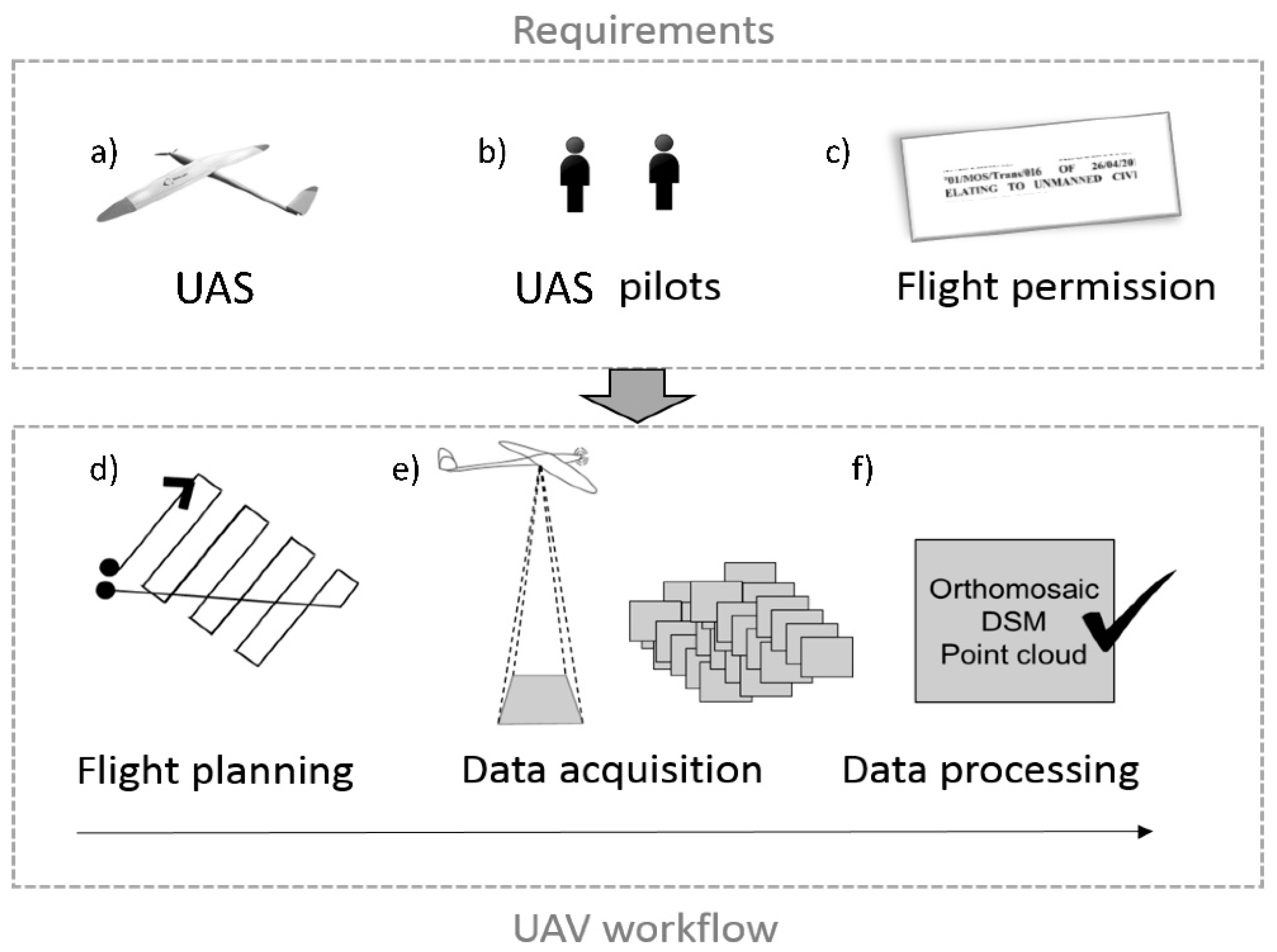
3.2. UAS Data Collection

In general, the UAS-based data acquisition workflow includes both technical and non-technical aspects. As shown in Figure 2, the UAS itself, the UAS pilots as well as the legal permission to conduct UAS flights refer to the main requirements to proceed with the data acquisition. In this research investigation, the UAS data collection aimed to provide an accurate orthophoto of the study area. Flight planning, data acquisition, and data processing were executed accordingly.

3.2.1. UAS Regulations in Rwanda

UAS related regulations are a vital requirement in the safe and successful use of UAS technology. In May 2016, the Ministerial Regulations N°01/MOS/Trans/016 relating to the use of UAS in Rwanda were officially gazetted [38]. Respective regulations are very prescriptive and contain subparts dealing with UAS registration and marking, privacy and safety, airworthiness certification, operating rules and pilot licensing [14]. Before any commencement of activities, the UAS needs to be registered and marked with a unique identifier. Furthermore, pilots, as well as operating agencies, need to hold specific licenses issued by Rwanda Civil Aviation Authority. These requirements demand a high standard of UAS professionality and make it a challenge for external companies and institutions to obtain legal flight permissions. At the time of writing, the authors were yet to complete the administrative procedure required (despite commencing the process in 2017) to operate UAS in Rwanda. Therefore all data collection flights were carried out by Charis UAS Ltd., a Rwandan company specialized in UAS services and the first UAS certified company in Rwanda. The experiences of the authors with the UAS regulations and respective governmental institutions point at very high institutional barriers for market entry. There is only one company which is a certified UAS operator (for land-related mapping) and arguably has a monopoly position. For the specific case related to the work at hand, processes were not transparent and slow with limited access and availability of authoritative, unambiguous and assured information. Although UAS regulations are in place, gaps and lack of capacity can be seen when it comes to both enforcement and implementation.
Besides requirements towards pilot certification, UAS registration, and operator certification, Rwandan UAS regulations outline several operational limitations that have to be taken into account during all UAS flight missions (Table 2). In general, most specifications reflect common restrictions [39] except for the lateral distance between the pilot and the UAS. Even though the visual line of sight remains undefined, the maximum lateral distance of the pilot to the UAS in operation was set to 300 m in 2016. This imposed a substantial constraint to UAS mapping projects. However, in the course of 2018, UAS regulations were revised, and the maximum lateral distance disappeared from the restrictions and the flight height was lifted to 120 m [40]. Specifications of restricted areas and requirements towards distances to structures and people are comparable to standard practice.

3.2.2. UAS Equipment

Three different types of UAS were tested in this study to assess the variety of UAS as a platform: one rotary-wing UAS (Inspire 2), one hybrid UAS (FireFLY 6) and one fixed-wing UAS (DT18). The consciously chosen platforms have different specifications in terms of operability, coverage, price, and necessity of ground control measurements. This study set-up reflected the broad spectrum of commonly used UAS and allowed to acknowledge these varieties within the assessment of the fitness of use. All platforms were equipped with an RGB sensor to capture nadir images (Table 3). The Inspire2 from DJI refers to semi-professional UAS with a focus for filmmaking. Both, the FireFLY6 and the DT18 PPK are survey-grade UAS of which the FireFLY6 presents a lower cost solution, and the DT18 PPK refers to a professional UAS with high-end components. The DT18 PPK is equipped with a combined Inertial Measurement Unit/ GNSS solution from Applanix (APX15) which allows direct georeferencing and minimizes the need for ground control measurements.
During flight planning, the first step for the UAS data collection, areas for take-off and landing, the UAS trajectory and the flying height are specified. A typical procedure to create the flight trajectory with strips is 80% forward overlap and 40–80% side overlap [1] since redundancy can compensate for aircraft instabilities. The flight planning configurations in this study were constraint by the regulations (operational limitations), requirements for accurate data in an urban environment and external flight conditions such as wind and illumination. Therefore, taking all these factors into account, the flight missions were carried out with 80% forward and 70% side overlap. According to the regulations, flight height was set to 100m above the surface. All UAS were equipped with a RGB sensor and resulting ground sampling distances varied between 2–3cm depending on the specification of the camera.
To emphasize the diversity of possible flight configurations, data collection included three different contexts–one urban study area, one peri-urban and one rural study area. The location of the study sites is visualized in Figure 3.
Due to the limited availability of open spaces, a hybrid UAS for the data collection of the densely populated urban environment in Muhoza Sector was chosen. In contrast, the rotary wing UAS was used to collect the images of the peri-urban area in Busogo Sector, as it is located on volcano slopes and highly affected by local wind systems which strongly influences the stability of fixed-wing UAS. Due to the regulatory restrictions and the difficulty to find sufficient large landing sites, the fixed-wing flight was conducted from a cricket stadium 20 km south of the City of Kigali. At the time of data acquisition, the maximum lateral distance of the pilot to the UAS was limited to 300m. Since only one area provided sufficient space for landing, the DT18 could only capture images over the cricket stadium which is embedded in a rural area in Gahanga Sector. Both, the Inspire 2 and the FireFLY6 were equipped with a consumer-grade GNSS antenna allowing geotagging of all images. However, the measurements of additional Ground Control Points (GCPs) indispensable. In contrast, the DT18 stood out for its high-quality navigation sensor that records precise attitude logs including both, angular observations (< 10 arcmins) as well as camera positions (<2.3 cm) [41]. However, former test flights showed, that the DT18 requires additional GCPs to correct for (minor) systematic errors [41], particularly when no GNSS corrections are applied.

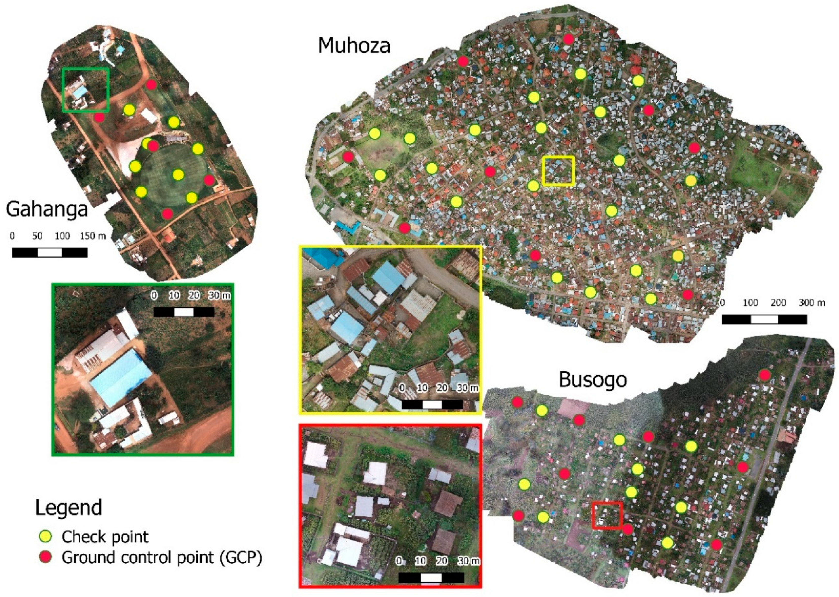
3.2.3. Ground Control Measurements

Reference points were deployed and measured in all three case locations to include known point coordinates for georeferencing as well as a means for quality control. Clearly visible ground marker had a quadratic shape with an edge length of 30 cm showing a black and white chess pattern (cf. Figure 4) which were evenly distributed in the area of interest. As specified in Table 4, ground truth measurements were carried out with two different GNSS devices. The first was a pair of Leica CS10 stations used in a base and rover set with a final RTK measurement accuracy of 2 cm. The second device used was a handheld Trimble GeoXH receiving RTK corrections via the Rwandan Continuously Operating Reference Station (CORS) GeoNet with a final measurement accuracy of 10 cm. Whereas GCPs were included as a weighted observation during the photogrammetric image processing [42], checkpoints were not taken into account during image processing and present as a classical way to evaluate the geometric accuracy. The georeferenced orthomosaic has been generated following two different block orientation methods. The Gahanga dataset was processed by means of an integrated sensor orientation method [43] that uses the information of camera positions and attitude as well as object coordinates of GCPs for the Bundle Block Adjustment. Since no attitude measurements were available for the FireFLY6 and for the Inspire 2, the block orientation of the Muhoza and Busogo dataset followed the GNSS-supported Aerial Triangulation method based on information on camera positions and object coordinates of GCPs [cf. 43].
Although less than ten reference points are sufficient to achieve high geometric accuracies, redundancy in deployed points has proven to be the preferable option as ground marker might get vanished or destroyed. Due to unforeseen administrative problems, the time between the deployment of the ground marker and the UAS flight itself was almost 5h. This can explain the fact that nearly 25% of all deployed points in the area of Muhoza were taken away. As summarised in Table 5, in the peri-urban and rural areas of Busogo and Gahanga the authors experienced less time delay as well as fewer losses of ground marker.

3.2.4. Software and Hardware Requirements

UAS data has been processed with the commercially available software Pix4D (www.pix4d.com) which refers to a well-established professional photogrammetric software. Next to commercially available software, freely available software for UAS image processing, such as Open Drone Map (www.opendronemap.org), offer viable alternatives. Open Drone Map follows a structure-from-motion pipeline which is based on Open SFM. Whereas previous open source software most often had the deficiency to not provide an intuitive, user-friendly user interface, Open Drone Map can be used as a command line tool, with a live USB or via a user-friendly Web-based graphical user interface. Recommended system requirements are similar for Pix4D and Open Drone Map, and refer to 16GB RAM for small projects over with 100–500 images, 32 GB RAM for projects over 500 images and 64 GB RAM for very large projects with over 2000 images. The photogrammetric processing in this paper was completed with Pix4D and took several hours for the Gahanga and Busogo dataset and more than a day for the Muhoza dataset.

4. Results

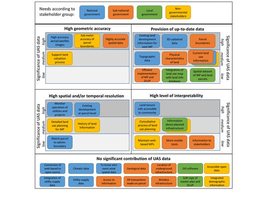
4.1. What Land Information do Rwandan Stakeholders Need?

The results of the needs assessment revealed that land information needs were not merely about data, but also other enabling requirements such as access, functionality and tool types. Table 6 and Table 7 show the outcomes of workshops with government and non-government stakeholders, and how final decisions around land information needs were prioritised. The column, ‘relative importance’ reflects the proportion of votes awarded to a specific need, while ‘popularity’ reflects the proportion of participants who voted for that need.

4.1.1. Government Stakeholders’ Needs

Spatial data with a high accuracy (although this was not quantified by participants) related to land tenure and other land information was a priority for both national and sub-national government stakeholders, attracting almost 20 and 30 percent of the total votes respectively. At both national and sub-national levels, the emphasis was less on land tenure information and more on other types of land information such as utilities, existing developments and land use, climatic and topographic data. Additionally, there was an emphasis on capacity needs (usability and accessibility), indicated in needs such as integration of land parcel other types of land information (e.g., utilities and administrative boundaries), the desire to transition to open source systems and have greater transparency around data custodianship and access rights, and implementation of the District Land Use Plan (DLUP) and masterplan.

4.1.2. Local Government and Communities’ Needs

Similar needs were identified by local government, who prioritized needs around digital data and supporting software, and a related desire for land tenure information to be more readily integrated with existing or planned land use and infrastructure. In general, land use tended to accord with the use defined on the title, but inconsistency is starting to be an issue in areas transitioning to more urban land use types. Here, it is common for the community to be found not using their land as zoned, or in some instances, attributed to the information on the title not being updated. For example, in one Cell, despite being rezoned for urban land use (residential), some land titles still reflected the previously planned agricultural land use. In these instances, it appeared that land records were only updated if the landowner formally seeks a building permit or other land-related services; otherwise, the land title remains unharmonised with the Master Plan. Also, although most of the land in Rwanda has been demarcated and titled during the LTRP, some plots (or owners who occupy the plots) remain untitled due to information gaps at the time of the LTRP, e.g.,, lack of identification, family disputes, etc. The use of general boundaries during the LTRP for demarcation for titling has also not been updated accurately due to the resolution of GPS receivers (3 meters) or lack of GPS receivers, leading to the on-ground practices like pacing by foot to resolve conflicts.
Lack of information, or lack of access to information, about the Master Plan (i.e., information about proposed new development) was identified. This inhibits the ability of local government to play a role in plan implementation. Additionally, given that the Master Plan plays a crucial role in setting out future development, it appears that local community consultation is ad hoc. For example, in some villages, local communities do not participate in the establishment of the master plan/LUP: in some others, only Cell officers are contacted, whereby it then falls onto them to inform the community; in yet others, local consultation has been undertaken.
In summary, it appears that at the Cell level, land information needs can be generalised as lack of access to development information (which affects land use practices and enforcement of intended land use types) and lack of up-to-date spatial and administrative information about individual parcels or persistent gaps in information.

4.1.3. Non-Government Stakeholders’ Needs

In contrast, non-government stakeholders’ needs were less focused on land tenure information and more on other information needs. Information needs like land value, land use, history of land, and proposed infrastructure were identified; the only tenure-related information was sub-meter accuracy of parcel boundaries in urban and peri-urban areas. It is no surprise that capacity needs around data accessibility, stakeholder engagement (e.g., consultation) and up-to-data web-based masterplans were all identified and prioritized.

4.2. What Data Quality can be Achieved with UAS-Technology?

The data quality can be derived from checkpoint residuals and a visual evaluation of the final orthomosaic. Final checkpoint residuals are outlined in Table 8. Almost pixel-level geometric accuracy was achieved with the Busogo dataset. Both Gahanga and Busogo show more than 10cm RMS error of horizontal residuals. Differences regarding final geometric accuracy can be attributed to the UAS equipment and sensor as well as to the device and conditions for the measurements of reference points. Nonetheless, obtained orthomosaics are of high geometric accuracy and comparable to results in other scientific contributions [44,45].
The visual evaluation revealed commonalities but also some differences in the datasets. Figure 5 presents the final orthomosaics of all three datasets. It is evident that sufficient overlap was considered during the flight missions as no gaps were present and the area of interest was entirely covered by the reconstructed scene. Differences of the visual quality are evident in the close-up views. Here, the image quality was best for the Muhoza dataset, as most features including rooftops, as well as vegetation, were well exposed in the orthomosaic. In contrast, the Busogo dataset showed a lower image quality, visible in over-exposed roofs and problems to fulfil a proper histogram matching during image processing. This can be attributed to the adverse lighting conditions during data capture. Even though meteorological conditions were perfect for flying during data capture of the Gahanga dataset, the sensor showed substantial difficulties to deal with bright and dark image features. Especially a large part of the parking area is very overexposed, even though the surface was covered with reddish gravel.

4.3. Can UAS Respond to the Needs Expressed by Different Stakeholders?

To draw conclusions on the ability of UAS data and UAS-based workflows to satisfy prioritized needs, the results of Table 6 and Table 7 were categorised and integrated in a matrix which distinguishes between (a) needs where UAS data has no significant contribution toward the achievement and (b) needs that can be matched with UAS data (Figure 6). The latter category was further associated to one of the four key characteristics of UAS data: high geometric accuracy, provision of up-to-date data, high spatial and/or temporal resolution, and high level of interpretability.
Figure 6 reveals that UAS data can have a significant contribution to match 27 out of 41 prioritised needs. The remaining 14 needs mainly refer to access to data, information, and software. A high and medium significance of UAS data was found mostly among national-level stakeholders, both governmental (eight needs) and non-governmental (seven needs) organisations. The needs of the local government could be met with medium (one need) or low (two needs) significant contributions of UAS data. Most of the prioritised needs of the sub-national government can only partially be fulfilled by UAS data (i.e., medium or low significance). A comparison of the four different characteristics shows that the provision of up to date data and the high level of interpretability are key in contributing to matching the stated needs. However, both aspects are highly interrelated to high geometric accuracy as well as high spatial resolution–otherwise, the data would not show such high level of detail which itself leads to high interpretability and its significant contribution to derive land use and topographic information. Although the quadrants in Figure 6 feature unique characteristics, all are interrelated and are therefore considered overlapping as well.
UAS regulations were found to have considerable impact on the scale of the utilisation of UAS in the context of land administration. Especially flight height and line of sight restrictions limit one data collection to several tens of hectares. Mapping larger areas would thus require constant moving of the ground control station with an adverse impact on the mapping efficiency. Geometric accuracy, was found to be less affected by UAS regulations. In contrast, the high level of interpretability and high spatial resolutions could be an issue when it comes to privacy and ethical constraints. Even though not the case in Rwanda, some countries demand public consent for the data collection of private property. A condition that requires sound data collection preparations and might put large restrictions on the UAS missions, particularly in urban and peri-urban areas.

4.3.1. High Geometric Accuracy

More specifically, the expressed need by government stakeholders for highly accurate spatial data can entirely be met by UAS imagery as shown by the low RMSE of checkpoint residuals in this study. Even though the national CORS in Rwanda cannot be considered as a source of GNSS corrections for PPK workflows, different means of georeferencing have proven to hit similar accuracies. This data characteristic facilitates the manual or digital delineation of parcel boundaries and support valuation and taxation processes–two needs which were prioritised by non-government stakeholders. The current cadastral map is based on the LTR programme which followed a general boundary approach which sometimes shows several meters offset to the correct location of the boundary. Most disputes arose during land transactions in densely populated areas, where plot sizes are small, and people depend on their land for subsistence farming. In those cases, UAS data ultimately facilitates a reliable and geometrically correct database to correct existing cadastral data.

4.3.2. Provision of up-to-Date Data

A comparison of the obtained UAS-based orthomosaic of Muhoza and the corresponding orthomosaic which is based on classical aerial photos from 2009 shows a high number of clearly visible changes (Figure 7), where 13 large buildings and 28 small buildings/annexes were newly constructed, 5 buildings were demolished, and 28 large buildings and 10 small buildings/annexes remained. Especially urban and peri-urban areas face numerous changes with regard to development and urbanization. The high level of detail and the immediate availability of aerial photos provide the geospatial basis to extract up-to-date land use, land development, and topographic information of small scale areas which is crucial to implement current urban development plans efficiently. Similarly, the timely provision of UAS data could support the delineation of parcel boundaries based on orthomosaics or regular base map updating activities. Especially up-to-date 3D point cloud data obtained from UAS images was identified as input for 3D cadastre. A data type, which can neither be provided by satellite images nor by aerial images.
A low significant contribution of UAS data can be seen in contributing to a multi-purpose spatial data infrastructure which enables the integration of different data, which can further support the implementation of spatial development plans. In general, UAS-based data acquisition workflows allow stakeholders to gradually upgrade existing base-maps at a small scale, without the need for significant financial outlay upfront–two fundamental aspects of fit-for-purpose approaches.

4.3.3. High Spatial and/or Temporal Resolution

The proven flexibility of UAS data acquisition supports the collection of a multi-temporal base data for on-going and current tasks such as the revision of the National Development Plans (i.e., Master Plans) for Secondary Cities or development plans for towns and villages. Frequent changes in land use projects can be tracked and monitored using repetitive UAS data collections, especially since plot sizes and administrative areas in Rwanda tend to be small and lend themselves well to UAS data capture. Additionally, disputes about former land ownership and land use can be solved more efficiently with evidence from a multi-temporal database (i.e., history of land information). Next to the temporal aspect, the high spatial resolution of UAS data allows users to extract information about developments at parcel level or a more detailed land use planning which also includes sub-uses in urban and peri-urban areas.

4.3.4. High Level of Interpretability

This fundamental characteristic is attributed to the high level of detail in the generated UAS products which itself allows for a straightforward interpretation of the aerial dataset. People are more likely to correctly interpret the orthophoto as they recognise specific textures of the surface or physical features such as bushes, hedges or particular buildings. This allows UAS data to have a significant contribution in providing the database for visualising land tenure data or planned infrastructure–an asset which supports participatory mapping activities for land administration or urban planning. The authors observed, that in many cases, de-jure land rights do not represent de-facto land rights as the cadastral maps show little details on the physical extent (except for the parcel boundary). The integration of an orthophoto in the cadastral map would support the alignment of de-facto and de-jure land rights as it would spatially outline adjudicated land rights that are easy to interpret even for laymen. Furthermore, UAS data could aid consultative processes of land use planning with clear and understandable background data. A profound significance of UAS data was found in support of maintaining a web-based spatial plan, promoting more mobile tools, and sharing information with stakeholders.

5. Discussion

This study was designed to determine the match between stakeholders’ needs and the characteristics of the UAS data acquisition workflow and its final products as useful spatial base data for land administration and spatial planning, particularly within the discourse of a more fit-for-purpose land administration.

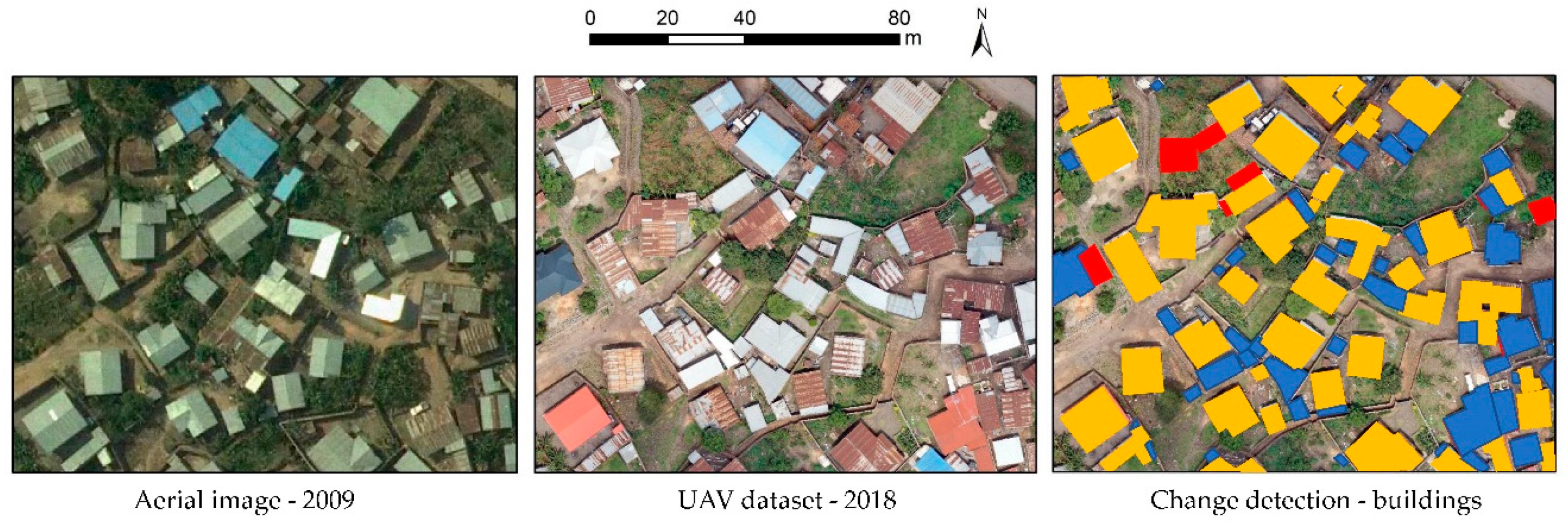
5.1. Opportunities of UAS Data Collection to Match Land Information Needs

The socio-technical assessment revealed that the technical capabilities of UAS-based data are well-placed to match most of the prioritised needs in Rwanda. These needs did not only reflect the type of data (e.g., land use data, geological data, utility supply data, etc.) but also on characteristics of data and processes (e.g., geometric accuracy, spatial resolution, custodian of data, data integration, accessibility, etc.). This enabled the matching of the characteristics of UAS data to a particular type of data as well as the specific requirements of the data such as temporal resolution or geometric accuracy. The synthesis as shown in Figure 6 demonstrates that there is a high number of needs where UAS data could potentially have a significant contribution. The results suggest that UAS as a data acquisition device could most likely be adopted by national-level stakeholders or sub-national government stakeholders, which can be attributed to the system in Rwanda where the national government is the main provider of geospatial data. However, with UAS as a low-cost and flexible data acquisition platform, sub-national or local government stakeholders could increase their share of data provision, especially with regard to small scale mapping or multi-temporal flight missions in a local context. This would facilitate the co-production of land information in a decentralized way, a finding that is also reflected by [19]. The opportunity of using UAS-based images to delineate or enhance the accuracy of parcel boundaries is in line with the guiding principles for building fit-for-purpose land administration systems in developing countries [46]. Here, UAS were specifically outlined to provide the large scale image maps to map spatial units in densely populated areas (urban central, informal settlements and small towns). Results further suggest that UAS data can fulfil multiple needs across different domains such as planning and surveying. This is contrary to conventional ground surveying with GNSS or total station, where acquired data only serves a single purpose. Although not explicitly prioritised as a need, the UAS test flights showed that the (nearly) immediate availability of orthophotos could promote citizen participation in the adjudication process, a critical result which was also outlined by [19,47]. Even though the Rwandan land administration information system is very advanced in comparison to other African countries, it was found that the digital nature of a generated UAS-based orthomosaic can easily be integrated in existing spatial data infrastructures to be used by numerous GIS applications, or if absent, support the modernization of current paper-based land registration systems.

5.2. Challenges of UAS Data Collection to Match Land Information Needs

Aside from those advantages, the UAS test flights in Rwanda also reveal four main challenges with regard to the implementation of UAS as a data acquisition tool to match land information needs.
Firstly, it needs to be noted that the terrain in Rwanda–the country of the thousand hills–is a very challenging testbed. Fixed wing drones have only limited climbing rates, and flight planning must be aligned with the physical environment. The availability of sufficient open space for appropriate landing strips is an essential precondition which was found to be challenging to fulfil. Hybrid UAS and rotary wing UAS are likely a more suitable instrument for small scale mapping activities. Current limitations with regard to battery capacity and flight time make hybrid UAS more effective for mapping tasks as they have aFRTK better flight endurance. In contrast, rotary wing UAS should be preferred to monitor the operation of utilities.
The second hurdle refers to the UAS regulations in Rwanda. With an operational limitation to fly only in visual line of sight, scaled application of UAS-mapping activities remain aspirational. Acknowledging the plans of the Government of Rwanda, legislation with a more performance-based orientation may soon be drafted and implemented more effectively. This development could pave the way for broader use of UAS-based data acquisition that supports land tenure recording, as well as extensive land information collection for development purposes, as envisaged in [48].
The third hurdle includes the topic of ground truthing. It has been shown that especially in an urban environment, the collection and measurement of reference points are challenging and means of ground marking should be context-specific. PPK and RTK capable UAS can provide an answer to this challenge as they minimise or even eliminate the need for ground control measurements. However, the availability of professional GNSS equipment or a national network of existing GNSS reference stations is an essential precondition for RTK or PPK-based workflows. If the national CORS is not reliable or not existing, other means of accurate GNSS measurements such as Precise Point Positioning should be taken into consideration.
The fourth challenge refers to soft- and hardware requirements for data processing. Experiences of the authors in Rwanda revealed that the majority of employees of the Rwanda Land Management and Use Authority have a machine which could be able to process smaller datasets up to 500 images. However, to facilitate the processing of the data of an entire township, machines with more RAM and disk space would be needed–ideally a server environment. Cloud-based processing is seen very critical, as internet connections are very often subject to outages. Financial barriers to purchase the required hardware and a commercial software such as Pix4D or similar were perceived as very high–costs that are likely to exceed the procurement costs of the UAS equipment. At the same time, current open source software cannot reproduce the same data quality as commercially available software. However, given the rapid development of Open Drone Map, and the increasing number of users, the software algorithm is likely to mature in the close future.

5.3. Limitations of this Research and Future Work

The scope of this study was limited regarding the validation of the UAS technology in a relevant environment but not in an operational environment as the UAS flights were only trialled without the direct implementation of the data. Thus, this study did not address gaps and challenges on how the expressed stakeholder needs were actually met in the context of Rwanda. Future work could address this with a strong focus on implementation to evaluate the fitness-of-use of UAS workflows with due consideration of the entire innovation chain including GIS applications. This could be coupled with the design and evaluation of appropriate governance and capacity building models to allow the prototype demonstration of UAS-based workflows in an operational environment. Additionally, further research will be needed to explore the role of UAS compared to other geospatial technologies such as satellite data and classical aerial photographs in providing base data that serves as a spatial framework for the various land administration functions [49].

6. Conclusions

The presented work highlights the capabilities of UAS technology to match the needs of land professionals in Rwanda. Results of a sound needs assessment across different stakeholder groups demonstrate prioritised demands of respective respondents. Although ranked differently, the need for high-resolution, up-to-date land information is consistently identified in the final lists of all group discussions. Across the globe, UAS have become an attractive technology and only the upcoming years will show whether multiple governmental and non-governmental stakeholders can capitalise on the numerous benefits of this data acquisition method. The flight missions in Rwanda showed that UAS as a platform to remotely capture images have clear advantages in terms of fit-for-purpose data provision by facilitating accurate, up-to-date data with a potentially high spatial as well as temporal resolution. However, the integration of the needs assessment and the UAS test flights indicates that structural and capacity conditions currently undermine the vast potential of the UAS data acquisition method. Therefore, a key policy priority should be to implement country-specific capacity development and governance strategies; otherwise, scaled implementation and increasing technology uptake might remain wishful thinking. Notwithstanding the outlined challenges, the results of this study show that UAS technology has the potential to be an appropriate land tool with a significant contribution in catering the base data for most of the prioritized land information needs in Rwanda.

Author Contributions

Conceptualization, C.S. (Claudia Stöcker), M.K., R.B. and J.Z.; Data curation, C.S. (Claudia Stöcker); Formal analysis, C.S. (Claudia Stöcker) and S.H.; Funding acquisition, R.B.; Investigation, C.S. (Claudia Stöcker), S.H., P.N. and C.S. (Cornelia Schmidt); Project administration, M.K.; Supervision, M.K. and J.Z.; Visualization, C.S. (Claudia Stöcker); Writing–original draft, C.S. (Claudia Stöcker) and S.H.; Writing–review & editing, C.S. (Claudia Stöcker), S.H., P.N., C.S. (Cornelia Schmidt), M.K., R.B. and J.Z.

Funding

The research described in this paper was funded by the research project “its4land,” which is part of the Horizon 2020 program of the European Union, project number 687828.

Acknowledgments

The authors thank Charis UAS Ltd. in Rwanda for the technical realization and support of all UAS test flights for this research investigation.

Conflicts of Interest

The authors declare no conflict of interest.

References

  1. Colomina, I.; Molina, P. Unmanned aerial systems for photogrammetry and remote sensing: A review. ISPRS J. Photogramm. Remote Sens. 2014, 92, 79–97. [Google Scholar] [CrossRef] [Green Version]
  2. Nex, F.; Remondino, F. UAV for 3D mapping applications: A review. Appl. Geomat. 2014, 6, 1–15. [Google Scholar] [CrossRef]
  3. Mesas-Carrascosa, F.J.; Notario-García, M.D.; de Larriva, M.D.N.G.; de la Orden, M.S.; Porras, A.G.F. Validation of measurements of land plot area using UAV imagery. Int. J. Appl. Earth Obs. Geoinf. 2014, 33, 270–279. [Google Scholar] [CrossRef]
  4. Honkavaara, E.; Kaivosoja, J.; Mäkynen, J.; Pellikka, I.; Pesonen, L.; Saari, H.; Salo, H.; Hakala, T.; Marklelin, L.; Rosnell, T. Hyperspectral Reflectance Signatures and Point Clouds for Precision Agriculture By Light Weight Uav Imaging System. Ann. Photogramm. Remote Sens. Spat. Inf. Sci. 2012, I-7, 353–358. [Google Scholar] [CrossRef]
  5. De Castro, A.I.; Torres-Sánchez, J.; Peña, J.M.; Jiménez-Brenes, F.M.; Csillik, O.; López-Granados, F. An automatic random forest-OBIA algorithm for early weed mapping between and within crop rows using UAV imagery. Remote Sens. 2018, 10, 285. [Google Scholar] [CrossRef]
  6. Eltner, A.; Kaiser, A.; Castillo, C.; Rock, G.; Neugirg, F.; Abellan, A. Image-based surface reconstruction in geomorphometry—Merits, limits and developments of a promising tool for geoscientists. Earth Surf. Dyn. Discuss. 2015, 1445–1508. [Google Scholar] [CrossRef]
  7. James, M.R.; Robson, S.; d’Oleire-Oltmanns, S.; Niethammer, U. Optimising UAV topographic surveys processed with structure-from-motion: Ground control quality, quantity and bundle adjustment. Geomorphology 2017, 280, 51–66. [Google Scholar] [CrossRef]
  8. Bemis, S.P.; Micklethwaite, S.; Turner, D.; James, M.R.; Akciz, S.; Thiele, S.T.; Bangash, H.A. Ground-based and UAV-Based photogrammetry: A multi-scale, high-resolution mapping tool for structural geology and paleoseismology. J. Struct. Geol. 2014, 69, 162–178. [Google Scholar] [CrossRef]
  9. Nikolakopoulos, K.G.; Kozarski, D.; Kogkas, S. Coastal areas mapping using UAV photogrammetry. Proc. SPIE 2017, 10428, 104280O. [Google Scholar]
  10. Szantoi, Z.; Smith, S.E.; Strona, G.; Koh, L.P.; Wich, S.A. Mapping orangutan habitat and agricultural areas using Landsat OLI imagery augmented with unmanned aircraft system aerial photography. Int. J. Remote Sens. 2017, 38, 2231–2245. [Google Scholar] [CrossRef] [Green Version]
  11. Adams, S.M.; Friedland, C.J. A Survey of Unmanned Aerial Vehicle (UAV) Usage for Imagery Collection in Disaster Research and Management. In Proceedings of the 9th International Workshop on Remote Sensing for Disaster Response, Stanfort University, Stanford, CA, USA, 15–16 September 2011. [Google Scholar]
  12. Erdelj, M.; Natalizio, E.; Chowdhury, K.R.; Akyildiz, I.F. Help from the Sky: Leveraging UAVs for Disaster Management. IEEE Pervasive Comput. 2017, 16, 24–32. [Google Scholar] [CrossRef]
  13. Pajares, G. Overview and Current Status of Remote Sensing Applications Based on Unmanned Aerial Vehicles (UAVs). Photogramm. Eng. Remote Sens. 2015, 81, 281–330. [Google Scholar] [CrossRef]
  14. Stöcker, C.; Bennett, R.; Nex, F.; Gerke, M.; Zevenbergen, J. Review of the current state of UAV regulations. Remote Sens. 2017, 9, 459. [Google Scholar] [CrossRef]
  15. Manyoky, M.; Theiler, P.; Steudler, D.; Eisenbeiss, H. Unmanned Aerial Vehicle in Cadastral Applications. ISPRS Int. Arch. Photogramm. Remote Sens. Spat. Inf. Sci. 2012, XXXVIII-1, 57–62. [Google Scholar] [CrossRef]
  16. Rijsdijk, M.; Van Hinsbergh, W.H.M.; Witteveen, W.; Buuren, G.H.M.; Schakelaar, G.A.; Poppinga, G.; Van Persie, M.; Ladiges, R. Unmanned Aerial Systems in the Process of Juridical Verification of Cadastral Border. Int. Arch. Photogramm. Remote Sens. 2013, XL, 4–6. [Google Scholar] [CrossRef]
  17. Barnes, G.; Volkmann, W. High-Resolution Mapping with Unmanned Aerial Systems. Surv. Land Inf. Sci. 2015, 74, 5–13. [Google Scholar]
  18. Mumbone, M.; Bennett, R.M.; Gerke, M.; Volkmann, W. Innovations in boundary mapping: Namibia, customary lands and UAVs. Proceedigs of the 16th Annual World Bank Conference on Land and Poverty 2015: Linking Land Tenure and Use for Shared Prosperity, Washington, DC, USA, 23–27 March 2015; Volume 1. [Google Scholar]
  19. Ramadhani, S.A.; Bennett, R.M.; Nex, F.C. Exploring UAV in Indonesian cadastral boundary data acquisition. Earth Sci. Inform. 2018, 11, 129–146. [Google Scholar] [CrossRef]
  20. Stöcker, C.; Koeva, M.; Bennett, R.; Zevenbergen, J. Evaluation of UAV-based technology to capture land rights in Kenya: Displaying stakeholder perspectives through interactive gaming. In Proceedings of the 20th Annual World Bank Conference on Land and Poverty 2019: Catalyzing Innovation, Washington, DC, USA, 25–29 March 2019. [Google Scholar]
  21. Enemark, S.; Bell, K.C.; Lemmen, C.; McLaren, R. Fit-For-Purpose Land Administration; World Bank and International Federation of Surveyors: Washington, DC, USA, 2014; ISBN 9788792853103. [Google Scholar]
  22. Zevenbergen, J.; De Vries, W.T.; Bennett, R.M. Advances in Responsible Land Administration; CRC Press: Boca Raton, FL, USA, 2015. [Google Scholar]
  23. Zevenbergen, J.; Augustinus, C.; Antonio, D.; Bennett, R. Pro-poor land administration: Principles for recording the land rights of the underrepresented. Land Use Policy 2013, 31, 595–604. [Google Scholar] [CrossRef]
  24. Ottens, M.; Stubkjær, E. A socio-technical analysis of cadastral systems. In Real Property Transactions; Zevenbergen, J., Frank, A., Stubkjær, E., Eds.; IOS Press: Clifton, VA, USA, 2007; p. 143. ISBN 9781586035815. [Google Scholar]
  25. Fourth Population and Housing Census, 2012 Census Atlas; National Institute of Statistics Rwanda (NISR): Kigali, Rwanda, 2014.
  26. Rwanda National Human Development Report 2014 (March 2015); UNDP and Government of Rwanda 2015: New York, NY, USA, 2015.
  27. Gillingham, P.; Buckle, F. Rwanda Land Tenure Regularisation Case Study; HTSPE Limited for Evidence on Demand and UK Department for International Development (DFID): Hertfordshire, UK, 2014.
  28. Ngoga, T.H. Rwanda’s Land Tenure Reform; CABI: Wallingford, UK, 2018. [Google Scholar]
  29. Rosen, J. MIT Technology Review. 2017. [Google Scholar]
  30. Delbecq, A.L.; Van de Ven, A.H.; Gustafson, D.H. Group Techniques for Program Planning: A Guide to Nominal Group and Delphi Processes; Green Briar Press: Denver, OR, USA, 1975; ISBN 9780673075918. [Google Scholar]
  31. Sink, D.S. Using the nominal group technique effectively. Natl. Product. Rev. 1983, 2, 173–184. [Google Scholar] [CrossRef]
  32. Witkin, B.R.; Altschuld, J.W. Planning and Conducting Needs Assessments: A Practical Guide; SAGE Publications Inc.: Thousand Oaks, CA, USA, 1995. [Google Scholar]
  33. World Bank Needs Assess. Knowl. Base; World Bank Institute Evaluation Group Nominal Group Technique: Washington, DC, USA, 2007.
  34. Delbecq, A.L.; Van de Ven, A.H. A group process model for problem identification and program planning. J. Appl. Behav. Sci. 1971, 7, 466–492. [Google Scholar] [CrossRef]
  35. Langford, B.E.; Schoenfeld, G.; Izzo, G. Nominal grouping sessions vs focus groups. Qual. Mark. Res. Int. J. 2002, 5, 58–70. [Google Scholar] [CrossRef]
  36. Lloyd, S. Applying the nominal group technique to specify the domain of a construct. Qual. Mark. Res. Int. J. 2011, 14, 105–121. [Google Scholar] [CrossRef]
  37. Cantrill, J.A.; Sibbald, B.; Buetow, S. The Delphi and nominal group techniques in health services research The Delphi technique. Int. J. Pharm. Pract. 1996, 4, 67–74. [Google Scholar] [CrossRef]
  38. RCAA Ministerial Regulations No 01/MOS/Trans/016 of 26/04/2016 Relating to Unmanned Civil Aircraft System; Rwanda Civil Aviation Authority: Kigali, Rwanda, 2016.
  39. Stöcker, C.; Ho, S.; Bennett, R.; Koeva, M.; Schmidt, C.; Nkerabigwi, P.; Zevenbergen, J. Towards UAV-based Land Tenure Data Acquisition in Rwanda: Needs Assessment and Technology Response. In Proceedings of the XXVI FIG Congress 2018: Embracing Our Smart World Where the Continents Connect: Enhancing the Geospatial Maturity of Societies, Istanbul, Turkey, 6–11 May 2018. [Google Scholar]
  40. RCAA Ministerial Regulations No 01/MOS/Trans/2018 of 23/01/2018 Relating to Unmanned Civil Aircraft System; Rwanda Civil Aviation Authority: Kigali, Rwanda, 2018.
  41. Stöcker, C.; Nex, F.; Koeva, M.; Gerke, M. Quality assessment of combined IMU/GNSS data for direct georeferencing in the context of UAV-based mapping. In Proceedings of the ISPRS 2017: International Conference on Unmanned Aerial Vehicles in Geomatics, Bonn, Germany, 4–7 September 2017; Volume 42. [Google Scholar]
  42. Remondino, F.; Barazzetti, L.; Nex, F.; Scaioni, M.; Sarazzi, D. Uav Photogrammetry for Mapping and 3D Modeling—Current Status and Future Perspectives. Int. Arch. Photogramm. 2011, XXXVIII, 14–16. [Google Scholar] [CrossRef]
  43. Benassi, F.; Dall’Asta, E.; Diotri, F.; Forlani, G.; di Cella, U.M.; Roncella, R.; Santise, M. Testing accuracy and repeatability of UAV blocks oriented with gnss-supported aerial triangulation. Remote Sens. 2017, 9, 172. [Google Scholar] [CrossRef]
  44. Gerke, M.; Przybilla, H.J. Accuracy Analysis of Photogrammetric UAV Image Blocks: Influence of Onboard RTK-GNSS and Cross Flight Patterns. Photogramm. Fernerkundung Geoinf. 2016, 17–30. [Google Scholar] [CrossRef]
  45. Agüera-Vega, F.; Carvajal-Ramírez, F.; Martínez-Carricondo, P. Assessment of photogrammetric mapping accuracy based on variation ground control points number using unmanned aerial vehicle. Meas. J. Int. Meas. Confed. 2017, 98, 221–227. [Google Scholar] [CrossRef]
  46. Enemark, S.; McLaren, R.; Lemmen, C.; Antonio, D.; Gitau, J. Guiding principles for building fit-for-purpose land administration systems in developing countries. In Proceedings of the Land and Poverty Conference 2016: Scaling up Responsible Land Governance, Washington, DC, USA, 14–18 March 2016. [Google Scholar]
  47. Widodo, S.; Safik, A.; Chaerani, M.; Pramudhiarta, N.; Hardiono, M.; Feld, S.; Barthel, K.; Rolfes, L.; Biringkanae, N.; Sugiri, A. Empowering Communities to Mark Boundaries and Map Resources with Geospatial Technology: Early Results of using UAVs in Participatory Village Boundary Setting/Resource Mapping (VBS/RM) activity in Indonesia. In Proceedings of the Land and Poverty Conference 2016: Scaling up Responsible Land Governance, Washington, DC, USA, 14–18 March 2016. [Google Scholar]
  48. NEPAD Drones on the Horizon—Transforming African’s Horizon; Union African: Addis Ababa, Ethiopia, 2018.
  49. Enemark, S. Building Land Information Policies. In Proceedings of the Special Forum on Building Land Information Policies in the Americas, Aguascalientes, Mexico, 26–27 October 2004. [Google Scholar]
Figure 1. Conceptual framework of the multi-disciplinary approach.
Remotesensing 11 01035 g001
Figure 2. Unmanned Aerial Systems (UAS) data collection–requirements and data acquisition workflow. (a) UAS equipment, payload and the ground control station; (b) trained staff to pilot and operate the UAS; (c) legal permission to conduct the UAS flight mission which can set its own requirements according to the national jurisdiction; (d) flight planning with an appropriate software and definition of flight characteristics; (e) acquisition of UAS images in the area of interest; (f) data cleansing and photogrammetric processing including quality assessment.
Remotesensing 11 01035 g002
Figure 3. Overview of UAS data collection sites in Rwanda.
Remotesensing 11 01035 g003
Figure 4. Measurement of reference points.
Remotesensing 11 01035 g004
Figure 5. Overview of the generated orthomosaics and GCP/checkpoint distribution.
Remotesensing 11 01035 g005
Figure 6. Prioritized needs classified by the ability of UAS data to match stated needs with further association to key characteristics of UAS data and ranking according to the significance of the contribution.
Remotesensing 11 01035 g006
Figure 7. Left: Orthomosaic based on aerial images from 2009; centre: Orthomosaic based on UAS images from 2018; right: Change detection of buildings (orange: buildings remained the same, red: buildings got demolished, blue: new building constructions).
Remotesensing 11 01035 g007
Table 1. Types of stakeholders participating in data collection workshops.
Stakeholder ClassOrganisations
ContactedParticipated
Public sector organizations specific to land administration (national, province, district, sector, cell levels)1212
Public sector organizations (adjacent domains to land)123
Non-statutory organizations11
Private sector organizations33
NGOs, Not-for-profit/Donors and Development partners;60
Research & Development (R&D)43
Table 2. Operational limitations for UAS flight missions in Rwanda according to Rwandan regulations [38,40].
Operational LimitationSpecification
Maximum take-off weight25 kg
Time for UAS operationOnly daylight operation
Minimum distance to aerodrome10 km
Maximum flight height100 m (increased to 120 m in 2018)
Visual Line Of SightRequired but undefined
Maximum lateral distance pilot to UAS300 m (abolished in 2018)
Minimum lateral distance to people, vessels, animals, building and structures30 m (increased to 100 m in 2018)
Restricted areasCongested areas of cities, towns or settlements
Ethics and privacyRespect privacy of oth ers, surveillance of peo ple and property with out their consent is pro hibited
Table 3. Specifications of UAS used in this study.
NameInspire 2 (DJI)FireFLY6 (BIRDSEYEVIEW)DT18 PPK (Delair Tech)
Remotesensing 11 01035 i001 Remotesensing 11 01035 i002 Remotesensing 11 01035 i003
TypeRotary wing UASHybrid UASFixed-wing UAS
SensorZenmuse X5SSONY A6000DT18 3Bands PPK
Sensor size13 x 17.3 mm23.5 x 15.6 mm8.45 x 7.07 mm
Pixel pitch2.48 µm3.92 µm3.45 µm
Sensor resolution5280 x 3956 (20.1MP)6000 x 4000 (24 MP)2448 x 2048 (5MP)
AreaBusogo (50 ha)–3 flightsMuhoza (94 ha)–2 flightsGahanga (14 ha)–1 flight
Data collection497 nadir images (total flight time: 45 min)991 nadir images
(total flight time: 60 min)
372 nadir images (total flight time: 20 min)
Main featuresVersality
Requires only small space for landing
Flight stability
Requires only small space for landing
Long endurance
Long flight endurance
PPK-capable
Automatic flight and landing mode
Table 4. Block orientation method and ground truthing information of all datasets.
DatasetBlock Orientation MethodGNSS Device for Ground Truthing MeasurementsCount GCPsCount Checkpoints
MuhozaGNSS-supported Aerial Triangulation (GNSS-AT)Leica CS10 and Trimble GeoXH920
BusogoGNSS-supported Aerial Triangulation (GNSS-AT)Leica CS1099
GahangaIntegrated Sensor OrientationTrimble GeoXH58
Table 5. Number of deployed reference points - count before and after the UAS flight.
AreaTeams DeployedReference Points Measured Pre-FlightReference Points Remained Post-FlightTime between Measurement and Final Collection of Ground Marker
Muhoza239305 h
Busogo122183 h
Gahanga113132 h
Table 6. Land information needs as identified by government stakeholders.
National Level GovernmentRelative ImportancePopularity
High accuracy satellite/aerial imagery18.70.8
To know who owns what spatial data 14.70.8
Current land use information9.30.4
3D cadastral data8.00.4
Utility supply data6.70.6
Convert existing web-based system to opensource6.70.2
Match land parcel to admin boundary6.70.2
Monitor operation of utilities and projects6.70.4
Integration of utility supply data6.70.4
Existing development at parcel level4.00.2
Sub-national level Government (District)
Highly accurate spatial data (incl. imagery)29.631.00
More mobile tools11.850.56
Physical characteristics of land11.850.44
Access to information10.370.56
Geological data8.150.33
Land use5.930.56
Implementation of masterplan and DLUP in an efficient way4.440.22
Parcel boundaries2.960.22
Location of underground infrastructure2.960.22
All transactions made on parcel1.480.11
Information to stakeholders 0.740.11
Wireless infrastructure0.740.11
Local level Government (Cell)
Spatial dataset of master plan and land parcels 0.67
GIS software 0.67
Soft copy of master plan 0.5
Soft copy of the DLUP 0.33
Integration of land use map with land information database 0.33
Information about planned infrastructure 0.17
Table 7. Land information needs identified by non-government stakeholders.
Non-GovernmentRelative ImportancePopularity
Value of land (valuation process)22.670.8
Accessible open data 18.670.6
Consultative process around land use planning12.000.4
More detailed (sub-use) land use planning in Master Plan10.670.6
Actual land use information 9.330.6
History of land Information to resolve conflict between infrastructure development and arable land9.330.6
Integrated demographic information6.670.6
Sub-meter accuracy of parcel boundaries (urban/peri-urban)6.670.4
Information about proposed infrastructure development and potential risks4.000.4
Maintained web-based Master Plans2.670.2
Table 8. Specifications of final results.
AreaGround Sampling DistanceRMS Error of CP Residuals (X/Y/Z)
Muhoza2.16 cm0.122m/0.086m/0.467m
Busogo2.18 cm0.033m/0.031m/0.349m
Gahanga2.63 cm0.127m/0.170m/0.244m

