Sentinel-1 SAR Amplitude Imagery for Rapid Landslide Detection

 ,
,  ,
,  and
and 
Abstract
1. Introduction
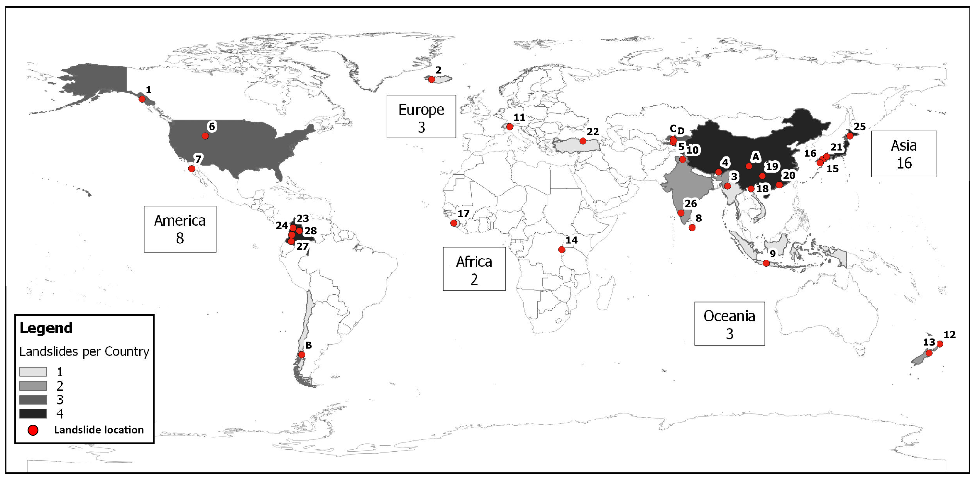
2. Test Cases
3. Data and Pre-Processing
3.1. Measures of Changes of between Pre- and Post-Event Images
3.2. Interpretation
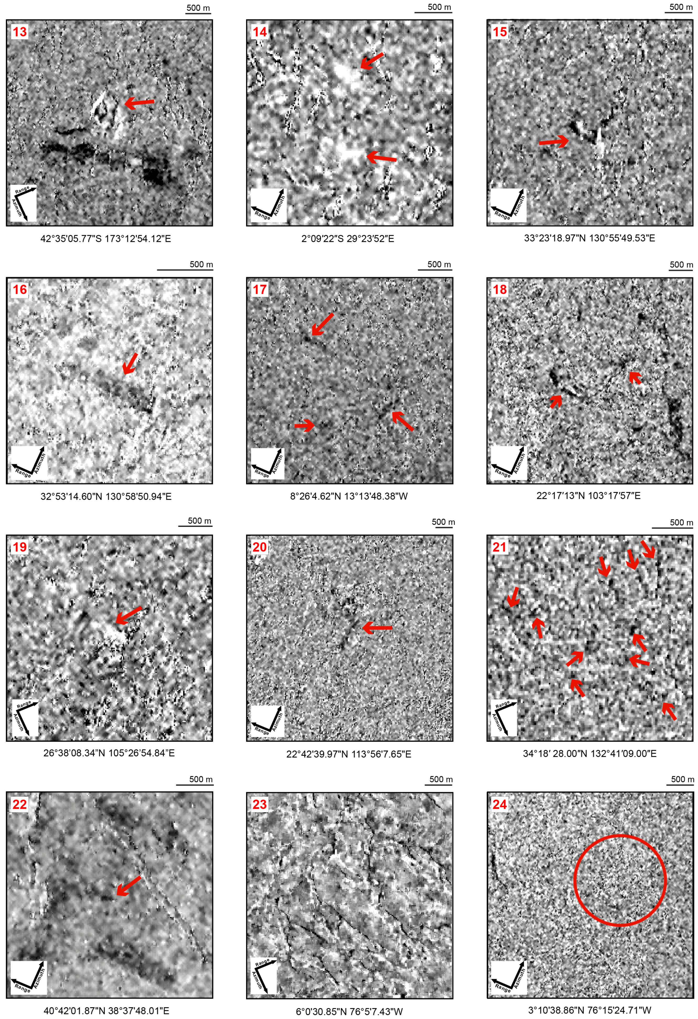
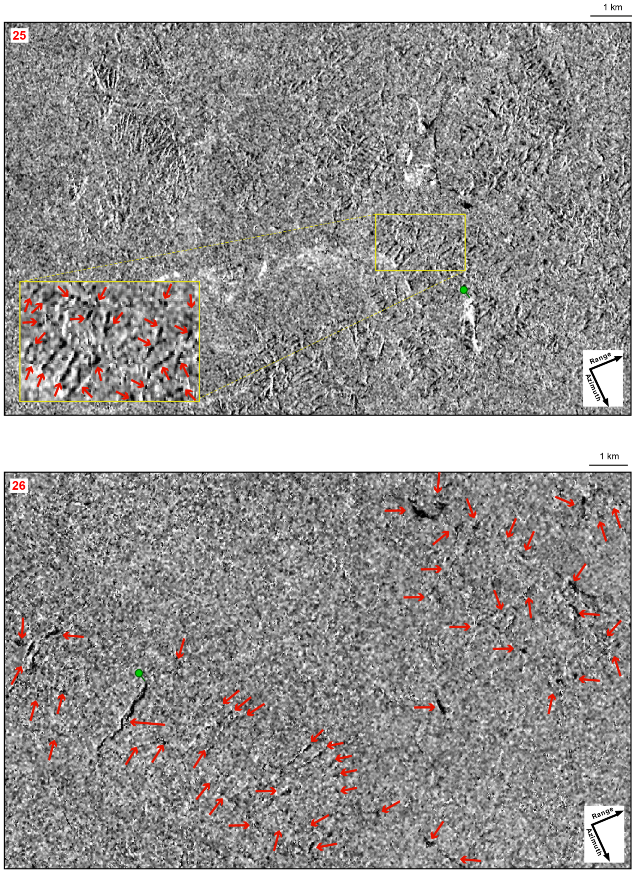
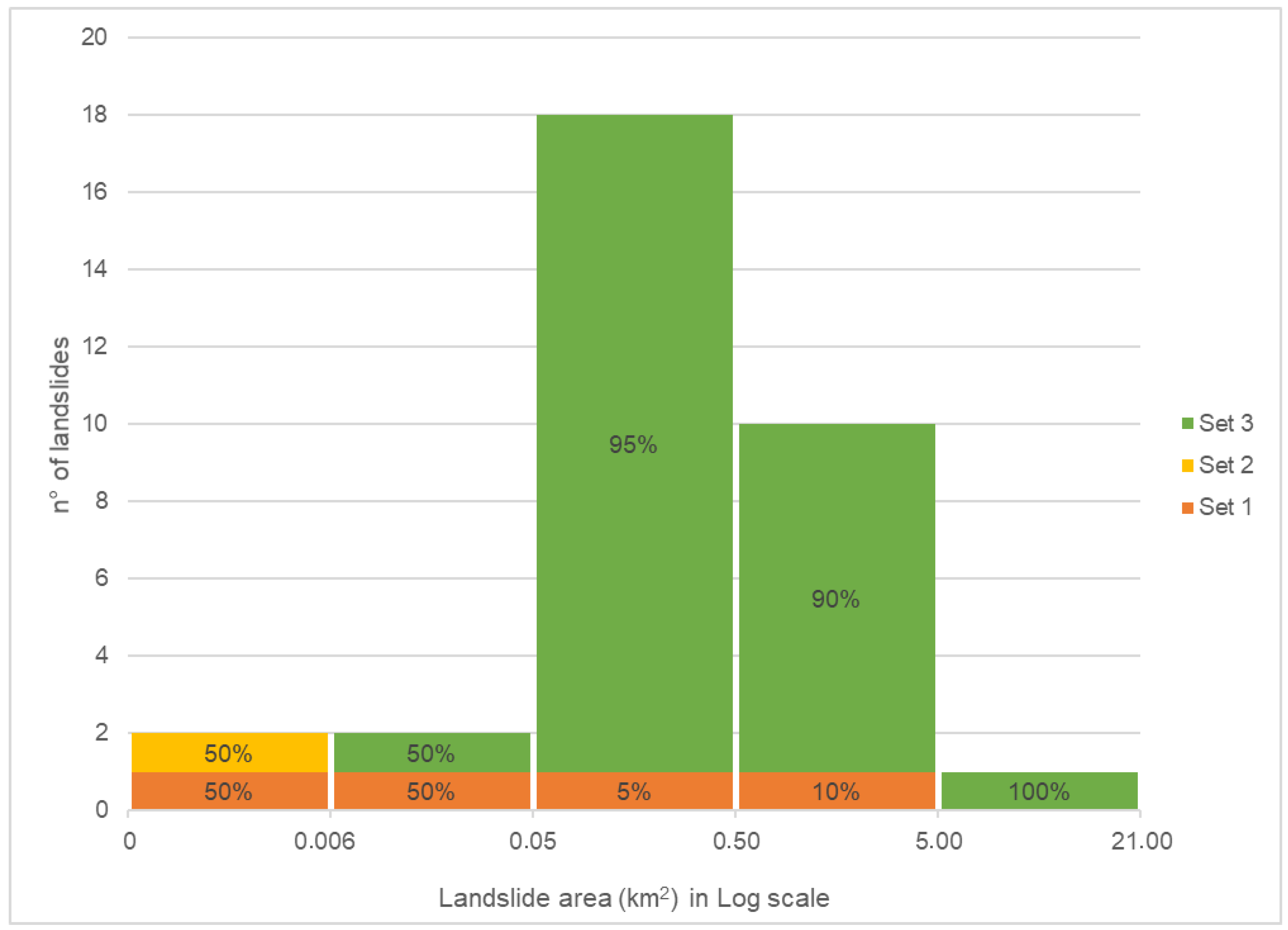
4. Results and Analysis
5. Discussion
6. Conclusions
Author Contributions
Funding
Acknowledgments
Conflicts of Interest
Appendix A

Appendix B

| ID | Track | Orbit | POST EVENT Image | PRE EVENT Image |
|---|---|---|---|---|
| 1 | 152 | Ascending | S1A_IW_SLC__1SSV_20160806T024605_20160806T024633_012474_0137F7_D97D | S1A_IW_SLC__1SSV_20160526T024600_20160526T024628_011424_011617_44DD |
| 2 | 16 | Ascending | S1A_IW_SLC__1SDV_20180717T185857_20180717T185924_022838_0279F5_B025 | S1A_IW_SLC__1SDV_20180623T185856_20180623T185923_022488_026F84_32C6 |
| 3 | 143 | Ascending | S1A_IW_SLC__1SSV_20150811T114745_20150811T114812_007215_009DE4_76C9 | S1A_IW_SLC__1SSV_20150718T114744_20150718T114811_006865_00942A_2799 |
| 4 | 4 | Descending | S1A_IW_SLC__1SDV_20171130T233727_20171130T233754_019501_02117D_7793 | S1A_IW_SLC__1SDV_20171118T233727_20171118T233754_019326_020C05_F81A |
| 5 | 5 | Descending | S1A_IW_SLC__1SSV_20160504T011247_20160504T011314_011102_010BB5_702B | S1A_IW_SLC__1SSV_20160410T011247_20160410T011313_010752_0100E1_B6A9 |
| 6 | 122 | Ascending | S1A_IW_SLC__1SDV_20170606T011848_20170606T011915_005923_00A638_1C81 | S1B_IW_SLC__1SDV_20170525T011847_20170525T011914_005748_00A123_B3E7 |
| 7 | 35 | Ascending | S1B_IW_SLC__1SDV_20170531T020608_20170531T020635_005836_00A3AE_1AA5 | S1B_IW_SLC__1SDV_20170519T020608_20170519T020635_005661_009EA1_7930 |
| 8 | 19 | Descending | S1A_IW_SLC__1SSV_20160716T002448_20160716T002516_012166_012DD0_1B6A | S1A_IW_SLC__1SSV_20160505T002441_20160505T002509_011116_010C15_C69F |
| 9 | 149 | Descending | S1A_IW_SLC__1SDV_20180304T222520_20180304T222548_020871_023CCB_9BD6 | S1A_IW_SLC__1SDV_20180220T222520_20180220T222548_020696_023742_C994 |
| 10 | 136 | Descending | S1A_IW_SLC__1SDV_20170824T005106_20170824T005133_018058_01E522_0F86 | S1A_IW_SLC__1SDV_20170812T005105_20170812T005132_017883_01DFD4_6567 |
| 11 | 66 | Descending | S1B_IW_SLC__1SDV_20170825T053412_20170825T053439_007092_00C7F7_8018 | S1B_IW_SLC__1SDV_20170813T053411_20170813T053438_006917_00C2E7_8739 |
| 12 | 175 | Descending | S1A_IW_SLC__1SDV_20180306T172124_20180306T172154_020897_023D98_F7AC | S1A_IW_SLC__1SDV_20180222T172124_20180222T172154_020722_02380F_4AEE |
| 13 | 73 | Descending | S1A_IW_SLC__1SSV_20161116T173100_20161116T173127_013970_016811_1786 | S1A_IW_SLC__1SSV_20160905T173100_20160905T173127_012920_0146D2_B6AC |
| 14 | 174 | Ascending | S1A_IW_SLC__1SDV_20180517T162025_20180517T162025_021946_025EAC_6C74 | S1A_IW_SLC__1SDV_20180505T162024_20180505T162051_021771_02591D_2CC1 |
| 15 | 156 | Ascending | S1B_IW_SLC__1SDV_20170714T091327_20170714T091402_006482_00B65B_40D7 | S1B_IW_SLC__1SDV_20170702T091326_20170702T091401_006307_00B16E_AE76 |
| 16 | 54 | Ascending | S1A_IW_SLC__1SDV_20160519T092157_20160519T092224_011326_0112E1_78CD | S1A_IW_SLC__1SDV_20151203T092153_20151203T092220_008876_00CB00_AB71 |
| 17 | 60 | Ascending | S1A_IW_SLC__1SDV_20170818T190805_20170818T190832_017982_01E2CF_BCD8 | S1A_IW_SLC__1SDV_20170806T190804_20170806T190831_017807_01DD81_C220 |
| 18 | 26 | Ascending | S1A_IW_SLC__1SDV_20180718T111440_20180718T111507_022848_027A43_386E | S1A_IW_SLC__1SDV_20180612T111438_20180612T111505_022323_026A94_19D0 |
| 19 | 164 | Descending | S1A_IW_SLC__1SDV_20170906T225727_20170906T225755_018261_01EB46_0B57 | S1A_IW_SLC__1SDV_20170825T225727_20170825T225755_018086_01E5F4_9E67 |
| 20 | 11 | Ascending | S1A_IW_SLC__1SDV_20151224T103309_20151224T103339_009183_00D39A_1C3B | S1A_IW_SLC__1SDV_20151212T103310_20151212T103340_009008_00CEA9_624B |
| 21 | 90 | Descending | S1A_IW_SLC__1SDV_20180710T210818_20180710T210846_022737_0276D8_9F2E | S1A_IW_SLC__1SDV_20180628T210818_20180628T210845_022562_0271AB_CB0A |
| 22 | 43 | Ascending | S1A_IW_SLC__1SDV_20160224T151754_20160224T151821_010090_00EDDE_760B | S1A_IW_SLC__1SDV_20150512T151748_20150512T151815_005890_00795C_FD88 |
| 23 | 142 | Descending | S1A_IW_SLC__1SSV_20150531T105025_20150531T105052_006164_00804A_A3BF | S1A_IW_SLC__1SSV_20150507T105023_20150507T105050_005814_0077A0_F26B |
| 24 | 48 | Ascending | S1B_IW_SLC__1SDV_20171115T232058_20171115T232125_008299_00EAEE_E985 | S1B_IW_SLC__1SDV_20171103T232058_20171103T232125_008124_00E5AE_F328 |
| 25 | 46 | Descending | S1A_IW_SLC__1SDV_20180905T204111_20180905T204139_023568_029131_BE2C | S1A_IW_SLC__1SDV_20180824T204111_20180824T204138_023393_028B99_998A |
| 26 | 63 | Descending | S1A_IW_SLC__1SDV_20180826T004813_20180826T004840_023410_028C24_DF28 | S1A_IW_SLC__1SDV_20180802T004811_20180802T004838_023060_0280E6_1133 |
| 27 | 142 | Descending | S1B_IW_SLC__1SSV_20170408T105103_20170408T105131_005068_008DD8_FE30 | S1B_IW_SLC__1SSV_20170327T105103_20170327T105131_004893_0088CA_547D |
| 28 | 150 | Ascending | S1B_IW_SLC__1SDV_20161103T231341_20161103T231409_002801_004BE6_7629 | S1B_IW_SLC__1SDV_20161010T231341_20161010T231409_002451_00422E_DE56 |
| A | 62 | Descending | S1A_IW_SLC__1SDV_20170713T230410_20170713T230437_017459_01D2E8_0F0C | S1A_IW_SLC__1SDV_20170619T230409_20170619T230436_017109_01C859_BEC5 |
| B | 83 | Descending | S1B_IW_SLC__1SDV_20171224T095748_20171224T095815_008859_00FC9E_99BC | S1B_IW_SLC__1SDV_20171212T095748_20171212T095815_008684_00F709_A672 |
| C | 5 | Descending | S1A_IW_SLC__1SSV_20160504T011247_20160504T011314_011102_010BB5_702B | S1A_IW_SLC__1SSV_20160410T011247_20160410T011313_010752_0100E1_B6A9 |
| D | 5 | Descending | S1A_IW_SLC__1SSV_20160504T011247_20160504T011314_011102_010BB5_702B | S1A_IW_SLC__1SSV_20160410T011247_20160410T011313_010752_0100E1_B6A9 |
References
- Cruden, D.M.; Varnes, D.J. Landslide types and processes. In Landslides, Investigation and Mitigation, Special Report 247; Turner, A., Schuster, R., Eds.; Transportation Research Board: Washington, DC, USA, 1996; pp. 36–75. [Google Scholar]
- Aleotti, P.; Chowdhury, R. Landslide hazard assessment: Summary review and new perspectives. Bull. Eng. Geol. Environ. 1999, 58, 21–44. [Google Scholar] [CrossRef]
- Guzzetti, F.; Mondini, A.C.; Cardinali, M.; Fiorucci, F.; Santangelo, M.; Chang, K.T. Landslide inventory maps: New tools for an old problem. Earth Sci. Rev. 2012, 112, 42–66. [Google Scholar] [CrossRef]
- Guzzetti, F.; Malamud, B.D.; Turcotte, D.L.; Reichenbach, P. Power-law correlations of landslide areas in central Italy. Earth Planet. Sci. Lett. 2002, 195, 169–183. [Google Scholar] [CrossRef]
- Malamud, B.D.; Turcotte, D.L.; Guzzetti, F.; Reichenbach, P. Landslide inventories and their statistical properties. Earth Surf. Process. Landf. 2004, 29, 687–711. [Google Scholar] [CrossRef]
- Rossi, M.; Guzzetti, F.; Reichenbach, P.; Mondini, A.C.; Peruccacci, S. Optimal landslide susceptibility zonation based on multiple forecasts. Geomorphology 2010, 114, 129–142. [Google Scholar] [CrossRef]
- Dikau, R. The recognition of landslides. In Floods and Landslides: Integrated Risk Assessment; Casale, R., Margottini, C., Eds.; Springer: Berlin/Heidelberg, Germany, 1999; pp. 39–44. [Google Scholar]
- Saba, S.B.; van der Meijde, M.; van der Werff, H. Spatiotemporal landslide detection for the 2005 Kashmir earthquake region. Geomorphology 2010, 124, 17–25. [Google Scholar] [CrossRef]
- Fiorucci, F.; Giordan, D.; Santangelo, M.; Dutto, F.; Rossi, M.; Guzzetti, F. Criteria for the optimal selection of remote sensing optical images to map event landslides. Nat. Hazards Earth Syst. Sci. 2018, 18, 405–417. [Google Scholar] [CrossRef]
- Kanevski, M.; Pozdnoukhov, A.; Timonin, V. Machine Learning for Spatial Environmental Data: Theory, Applications and Software; EPFL Press: Lausanne, Switzerland; Boca Raton, FL, USA, 2009; p. 377. [Google Scholar]
- Martha, T.R.; Kerle, N.; van Westen, C.J.; Jetten, V.; Kumar, K.V. Segment Optimization and Data-Driven Thresholding for Knowledge-Based Landslide Detection by Object-Based Image Analysis. IEEE Trans. Geosci. Remote Sens. 2011, 49, 4928–4943. [Google Scholar] [CrossRef]
- Mondini, A.C. Measures of Spatial Autocorrelation Changes in Multitemporal SAR Images for Event Landslides Detection. Remote Sens. 2017, 9, 554. [Google Scholar] [CrossRef]
- Plank, S.; Twele, A.; Martinis, S. Landslide Mapping in Vegetated Areas Using Change Detection Based on Optical and Polarimetric SAR Data. Remote Sens. 2016, 8, 307. [Google Scholar] [CrossRef]
- Wilson, A.M.; Jetz, W. Remotely Sensed High-Resolution Global Cloud Dynamics for Predicting Ecosystem and Biodiversity Distributions. PLoS Biol. 2016, 14, e1002415. [Google Scholar] [CrossRef]
- Li, J.; Roy, D.P. A Global Analysis of Sentinel-2A, Sentinel-2B and Landsat-8 Data Revisit Intervals and Implications for Terrestrial Monitoring. Remote Sens. 2017, 9, 902. [Google Scholar]
- Kovalskyy, V.; Roy, D. The global availability of Landsat 5 TM and Landsat 7 ETM+ land surface observations and implications for global 30m Landsat data product generation. Remote Sens. Environ. 2013, 130, 280–293. [Google Scholar] [CrossRef]
- Ju, J.; Roy, D.P. The availability of cloud-free Landsat ETM+ data over the conterminous United States and globally. Remote Sens. Environ. 2008, 112, 1196–1211. [Google Scholar] [CrossRef]
- Surendranath, M.; Ghosh, S.; Ghoshal, T.B.; Rajendran, N. Landslide Hazard Zonation in Darjeeling Himalayas: A Case Study on Integration of IRS and SRTM Data. In Remote Sensing and GIS Technologies for Monitoring and Prediction of Disasters; Nayak, S., Zlatanova, S., Eds.; Springer: Berlin/Heidelberg, Germany, 2008; pp. 121–135. [Google Scholar]
- Starkel, L. The Role of Catastrophic Rainfall in the Shaping of the Relief of the Lower Himalaya (Darjeeling Hills). Geogr. Polon. 1972, 21, 103–160. [Google Scholar]
- Williams, J.G.; Rosser, N.J.; Kincey, M.E.; Benjamin, J.; Oven, K.J.; Densmore, A.L.; Milledge, D.G.; Robinson, T.R.; Jordan, C.A.; Dijkstra, T.A. Satellite-based emergency mapping using optical imagery: Experience and reflections from the 2015 Nepal earthquakes. Nat. Hazards Earth Syst. Sci. 2018, 18, 185–205. [Google Scholar] [CrossRef]
- BGS. Ecuador Earthquake Disaster Response. 2016. Available online: https://www.bgs.ac.uk/research/earthHazards/epom/ecuadorEarthquake.html (accessed on 28 January 2019).
- Da Costa Freitas, C.; de Souza Soler, L.; Sant’Anna, S.J.S.; Dutra, L.V.; dos Santos, J.R.; Mura, J.C.; Correia, A.H. Land Use and Land Cover Mapping in the Brazilian Amazon Using Polarimetric Airborne P-Band SAR Data. IEEE Trans. Geosci. Remote Sens. 2008, 46, 2956–2970. [Google Scholar] [CrossRef]
- Lonnqvist, A.; Rauste, Y.; Molinier, M.; Hame, T. Polarimetric SAR Data in Land Cover Mapping in Boreal Zone. IEEE Trans. Geosci. Remote Sens. 2010, 48, 3652–3662. [Google Scholar] [CrossRef]
- Xu, H.; Steven, M.D.; Jaggard, K.W. Monitoring leaf area of sugar beet using ERS-1 SAR data. Int. J. Remote Sens. 1996, 17, 3401–3410. [Google Scholar] [CrossRef]
- Yang, Z.; Li, K.; Liu, L.; Shao, Y.; Brisco, B.; Li, W. Rice growth monitoring using simulated compact polarimetric C band SAR. Radio Sci. 2014, 49, 1300–1315. [Google Scholar] [CrossRef]
- Guneriussen, T.; Johnsen, H.; Sand, K. DEM corrected ERS-1 SAR data for snow monitoring. Int. J. Remote Sens. 1996, 17, 181–195. [Google Scholar] [CrossRef]
- Bernier, M.; Fortin, J. The potential of times series of C-Band SAR data to monitor dry and shallow snow cover. IEEE Trans. Geosci. Remote Sens. 1998, 36, 226–243. [Google Scholar] [CrossRef]
- Nagler, T.; Rott, H.; Ripper, E.; Bippus, G.; Hetzenecker, M. Advancements for Snowmelt Monitoring by Means of Sentinel-1 SAR. Remote Sens. 2016, 8, 348. [Google Scholar] [CrossRef]
- Li, F.; Wang, Z.; Zhang, S.; Zhang, Y. Glacier Frontal Line Extraction from SENTINEL-1 SAR Imagery in Prydz Area. ISPRS Int. Arch. Photogramm. Remote Sens. Spat. Inf. Sci. 2018, XLII-3, 801–805. [Google Scholar] [CrossRef]
- Nagler, T.; Rott, H.; Hetzenecker, M.; Scharrer, K.; Magnússon, E.; Floricioiu, D.; Notarnicola, C. Retrieval of 3D-glacier movement by high resolution X-band SAR data. In Proceedings of the 2012 IEEE International Geoscience and Remote Sensing Symposium, Munich, Germany, 22–27 July 2012; pp. 3233–3236. [Google Scholar]
- Lu, Z.; Meyer, D.J. Study of high SAR backscattering caused by an increase of soil moisture over a sparsely vegetated area: Implications for characteristics of backscattering. Int. J. Remote Sens. 2002, 23, 1063–1074. [Google Scholar] [CrossRef]
- Yang, L.; Feng, X.; Liu, F.; Liu, J.; Sun, X. Potential of soil moisture estimation using C-band polarimetric SAR data in arid regions. Int. J. Remote Sens. 2019, 40, 2138–2150. [Google Scholar] [CrossRef]
- Beaudoin, A.; Toan, T.L.; Goze, S.; Nezry, E.; Lopes, A.; Mougin, E.; Hsu, C.C.; Han, H.C.; Kong, J.A.; Shin, R.T. Retrieval of forest biomass from SAR data. Int. J. Remote Sens. 1994, 15, 2777–2796. [Google Scholar] [CrossRef]
- Bazi, Y.; Bruzzone, L.; Melgani, F. An unsupervised approach based on the generalized Gaussian model to automatic change detection in multitemporal SAR images. IEEE Trans. Geosci. Remote Sens. 2005, 43, 874–887. [Google Scholar] [CrossRef]
- Bovolo, F.; Bruzzone, L. A detail-preserving scale-driven approach to change detection in multitemporal SAR images. IEEE Trans. Geosci. Remote Sens. 2005, 43, 2963–2972. [Google Scholar] [CrossRef]
- Rignot, E.J.M.; van Zyl, J.J. Change detection techniques for ERS-1 SAR data. IEEE Trans. Geosci. Remote Sens. 1993, 31, 896–906. [Google Scholar] [CrossRef]
- Oberstadler, R.; Hönsch, H.; Huth, D. Assessment of the mapping capabilities of ERS-1 SAR data for flood mapping: A case study in Germany. Hydrol. Process. 1997, 11, 1415–1425. [Google Scholar] [CrossRef]
- Jenkins, L.K.; Bourgeau-Chavez, L.L.; French, N.H.F.; Loboda, T.V.; Thelen, B.J. Development of Methods for Detection and Monitoring of Fire Disturbance in the Alaskan Tundra Using a Two-Decade Long Record of Synthetic Aperture Radar Satellite Images. Remote Sens. 2014, 6, 6347–6364. [Google Scholar] [CrossRef]
- Gamba, P.; Dell’Acqua, F.; Lisini, G. Change Detection of Multitemporal SAR Data in Urban Areas Combining Feature-Based and Pixel-Based Techniques. IEEE Trans. Geosci. Remote Sens. 2006, 44, 2820–2827. [Google Scholar] [CrossRef]
- Burrows, K.; Walters, R.J.; Milledge, D.; Spaans, K.; Densmore, A.L. A New Method for Large-Scale Landslide Classification from Satellite Radar. Remote Sens. 2019, 11, 237. [Google Scholar] [CrossRef]
- Martinis, S.; Kersten, J.; Twele, A. A fully automated TerraSAR-X based flood service. ISPRS J. Photogramm. Remote Sens. 2015, 104, 203–212. [Google Scholar] [CrossRef]
- Meyer, F.; McAlpin, D.; Gong, W.; Ajadi, O.; Arko, S.; Webley, P.; Dehn, J. Integrating SAR and derived products into operational volcano monitoring and decision support systems. ISPRS J. Photogramm. Remote Sens. 2015, 100, 106–117. [Google Scholar] [CrossRef]
- Yun, S.; Agram, P.S.; Fielding, E.J.; Simons, M.; Webb, F.; Tanaka, A.; Lundgren, P.; Owen, S.E.; Rosen, P.A.; Hensley, S. Damage Proxy Map from InSAR Coherence Applied to February 2011 M6.3 Christchurch Earthquake, 2011 M9.0 Tohoku-oki Earthquake, and 2011 Kirishima Volcano Eruption. In AGU Fall Meeting Abstracts; AGU Publ.: San Francisco, CA, USA, 2011; p. NH31A-1533. [Google Scholar]
- Ajadi, O.A.; Meyer, F.J.; Webley, P.W. Change Detection in Synthetic Aperture Radar Images Using a Multiscale-Driven Approach. Remote Sens. 2016, 8, 482. [Google Scholar] [CrossRef]
- Singh, A. Review Article Digital change detection techniques using remotely-sensed data. Int. J. Remote Sens. 1989, 10, 989–1003. [Google Scholar] [CrossRef]
- Bruzzone, L.; Fernández-Prieto, D. Automatic analysis of the difference image for unsupervised change detection. IEEE Trans. Geosci. Remote Sens. 2000, 38, 1171–1182. [Google Scholar] [CrossRef]
- Dekker, R.J. Speckle filtering in satellite SAR change detection imagery. Int. J. Remote Sens. 1998, 19, 1133–1146. [Google Scholar] [CrossRef]
- Oliver, C.; Quegan, S. Understanding Synthetic Aperture Radar Images; SciTech Radar and Defense Series; SciTech Publ.: Raleigh, NC, USA, 2004. [Google Scholar]
- Sidle, R.C.; Ochiai, H. Landslides: Processes, Prediction, and Land Use; Water Resources Monograph; AGU Publ: Washington, DC, USA, 2006; p. 312. [Google Scholar]
- Jin, Y.Q.; Wang, D. Automatic Detection of Terrain Surface Changes After Wenchuan Earthquake, May 2008, From ALOS SAR Images Using 2EM-MRF Method. IEEE Geosci. Remote Sens. Lett. 2009, 6, 344–348. [Google Scholar]
- Raspini, F.; Ciampalini, A.; Del Conte, S.; Lombardi, L.; Nocentini, M.; Gigli, G.; Ferretti, A.; Casagli, N. Exploitation of Amplitude and Phase of Satellite SAR Images for Landslide Mapping: The Case of Montescaglioso (South Italy). Remote Sens. 2015, 7, 14576–14596. [Google Scholar] [CrossRef]
- Singhroy, V.; Mattar, K.; Gray, A. Landslide characterisation in Canada using interferometric SAR and combined SAR and TM images. Adv. Space Res. 1998, 21, 465–476. [Google Scholar] [CrossRef]
- Czuchlewski, K.R.; Weissel, J.K.; Kim, Y. Polarimetric synthetic aperture radar study of the Tsaoling landslide generated by the 1999 Chi-Chi earthquake, Taiwan. J. Geophys. Res. Earth Surf. 2003, 108, 6006. [Google Scholar] [CrossRef]
- Manconi, A.; Casu, F.; Ardizzone, F.; Bonano, M.; Cardinali, M.; De Luca, C.; Gueguen, E.; Marchesini, I.; Parise, M.; Vennari, C.; et al. Brief Communication: Rapid mapping of landslide events: The 3 December 2013 Montescaglioso landslide, Italy. Nat. Hazards Earth Syst. Sci. 2014, 14, 1835–1841. [Google Scholar] [CrossRef]
- Tessari, G.; Floris, M.; Pasquali, P. Phase and amplitude analyses of SAR data for landslide detection and monitoring in non-urban areas located in the North-Eastern Italian pre-Alps. Environ. Earth Sci. 2017, 76, 85. [Google Scholar] [CrossRef]
- Konishi, T.; Suga, Y. Landslide detection using COSMO-SkyMed images: A case study of a landslide event on Kii Peninsula, Japan. Eur. J. Remote Sens. 2018, 51, 205–221. [Google Scholar] [CrossRef]
- Kimura, H.; Yamaguchi, Y. Detection of landslide areas using satellite radar interferometry. PE&RS Photogramm. Eng. Remote Sens. 2000, 66, 337–344. [Google Scholar]
- Riedel, B.; Walther, A. InSAR processing for the recognition of landslides. Adv. Geosci. 2008, 14, 189–194. [Google Scholar] [CrossRef]
- Zhao, C.; Lu, Z.; Zhang, Q.; de la Fuente, J. Large-area landslide detection and monitoring with ALOS/PALSAR imagery data over Northern California and Southern Oregon, USA. Remote Sens. Environ. 2012, 124, 348–359. [Google Scholar] [CrossRef]
- Zhao, C.; Zhang, Q.; Yin, Y.; Lu, Z.; Yang, C.; Zhu, W.; Li, B. Pre-, co-, and post- rockslide analysis with ALOS/PALSAR imagery: A case study of the Jiweishan rockslide, China. Nat. Hazards Earth Syst. Sci. 2013, 13, 2851–2861. [Google Scholar] [CrossRef]
- Zhao, C.; Lu, Z. Remote Sensing of Landslides—A Review. Remote Sens. 2018, 10, 279. [Google Scholar] [CrossRef]
- Ugai, K.; Yagi, H.; Wakai, A. Earthquake-Induced Landslides: Proceedings of the International Symposium on Earthquake-Induced Landslides, Kiryu, Japan, 2012; Springer: Berlin/Heidelberg, Germany, 2012. [Google Scholar]
- Geudtner, D.; Torres, R.; Snoeij, P.; Davidson, M.; Rommen, B. Sentinel-1 System capabilities and applications. In Proceedings of the 2014 IEEE Geoscience and Remote Sensing Symposium, Quebec City, QC, Canada, 13–18 July 2014; pp. 1457–1460. [Google Scholar]
- Schlögel, R.; Doubre, C.; Malet, J.P.; Masson, F. Landslide deformation monitoring with ALOS/PALSAR imagery: A D-InSAR geomorphological interpretation method. Geomorphology 2015, 231, 314–330. [Google Scholar] [CrossRef]
- Dai, K.; Li, Z.; Tomás, R.; Liu, G.; Yu, B.; Wang, X.; Cheng, H.; Chen, J.; Stockamp, J. Monitoring activity at the Daguangbao mega-landslide (China) using Sentinel-1 TOPS time series interferometry. Remote Sens. Environ. 2016, 186, 501–513. [Google Scholar] [CrossRef]
- Kalia, A.; Frei, M.; Lege, T. A Copernicus downstream-service for the nationwide monitoring of surface displacements in Germany. Remote Sens. Environ. 2017, 202, 234–249. [Google Scholar] [CrossRef]
- Novellino, A.; Cigna, F.; Brahmi, M.; Sowter, A.; Bateson, L.; Marsh, S. Assessing the Feasibility of a National InSAR Ground Deformation Map of Great Britain with Sentinel-1. Geosciences 2017, 7, 19. [Google Scholar] [CrossRef]
- Barra, A.; Monserrat, O.; Mazzanti, P.; Esposito, C.; Crosetto, M.; Mugnozza, G.S. First insights on the potential of Sentinel-1 for landslides detection. Geomat. Nat. Hazards Risk 2016, 7, 1874–1883. [Google Scholar] [CrossRef]
- Barra, A.; Monserrat, O.; Crosetto, M.; Cuevas-Gonzalez, M.; Devanthéry, N.; Luzi, G.; Crippa, B. Sentinel-1 Data Analysis for Landslide Detection and Mapping: First Experiences in Italy and Spain; Advancing Culture of Living with Landslides; Mikoš, M., Arbanas, Ž., Yin, Y., Sassa, K., Eds.; Springer International Publishing: Cham, Switzerland, 2017; pp. 201–208. [Google Scholar]
- Intrieri, E.; Raspini, F.; Fumagalli, A.; Lu, P.; Del Conte, S.; Farina, P.; Allievi, J.; Ferretti, A.; Casagli, N. The Maoxian landslide as seen from space: Detecting precursors of failure with Sentinel-1 data. Landslides 2018, 15, 123–133. [Google Scholar] [CrossRef]
- Dai, K.; Chen, G.; Xu, Q.; Li, Z.; Qu, T.; Hu, L.; Lu, H. Potential Landslide Early Detection near Wenchuan by a Qualitatively Multi-Baseline DInSAR Method. ISPRS Int. Arch. Photogramm. Remote Sens. Spat. Inf. Sci. 2018, XLII-3, 253–256. [Google Scholar] [CrossRef]
- Delacourt, C.; Allemand, P.; Berthier, E.; Raucoules, D.; Casson, B.; Grandjean, P.; Pambrun, C.; Varel, E. Remote-sensing techniques for analysing landslide kinematics: A review. Bull. Société Géologique Fr. 2007, 178, 89–100. [Google Scholar] [CrossRef]
- Vöge, M.; Frauenfelder, R.; Ekseth, K.; Arora, M.K.; Bhattacharya, A.; Basin, R.K. The use of SAR interferometry for landslide mapping in the Indian Himalayas. ISPRS Int. Arch. Photogramm. Remote Sens. Spat. Inf. Sci. 2015, XL-7/W3, 857–863. [Google Scholar]
- Casagli, N.; Cigna, F.; Bianchini, S.; Hölbling, D.; Füreder, P.; Righini, G.; Conte, S.D.; Friedl, B.; Schneiderbauer, S.; Iasio, C.; et al. Landslide mapping and monitoring by using radar and optical remote sensing: Examples from the EC-FP7 project SAFER. Remote Sens. Appl. Soc. Environ. 2016, 4, 92–108. [Google Scholar] [CrossRef]
- Casagli, N.; Frodella, W.; Morelli, S.; Tofani, V.; Ciampalini, A.; Intrieri, E.; Raspini, F.; Rossi, G.; Tanteri, L.; Lu, P. Spaceborne, UAV and ground-based remote sensing techniques for landslide mapping, monitoring and early warning. Geoenviron. Disasters 2017, 4, 9. [Google Scholar] [CrossRef]
- Pepe, A.; Calò, F. A Review of Interferometric Synthetic Aperture RADAR (InSAR) Multi-Track Approaches for the Retrieval of Earth’s Surface Displacements. Appl. Sci. 2017, 7, 1264. [Google Scholar] [CrossRef]
- Luca, C.D.; Bonano, M.; Casu, F.; Fusco, A.; Lanari, R.; Manunta, M.; Manzo, M.; Pepe, A.; Zinno, I. Automatic and Systematic Sentinel-1 SBAS-DInSAR Processing Chain for Deformation Time-series Generation. Procedia Comput. Sci. 2016, 100, 1176–1180. [Google Scholar] [CrossRef]
- Plank, S. Rapid Damage Assessment by Means of Multi-Temporal SAR—A Comprehensive Review and Outlook to Sentinel-1. Remote Sens. 2014, 6, 4870–4906. [Google Scholar] [CrossRef]
- Bioresita, F.; Puissant, A.; Stumpf, A.; Malet, J.P. A Method for Automatic and Rapid Mapping of Water Surfaces from Sentinel-1 Imagery. Remote Sens. 2018, 10, 217. [Google Scholar] [CrossRef]
- Petley, D. The Landslide Blog. 2018. Available online: https://blogs.agu.org/landslideblog (accessed on 15 November 2018).
- Petley, D. Global patterns of loss of life from landslides. Geology 2012, 40, 927–930. [Google Scholar] [CrossRef]
- ESA. Copernicus Open Access Hub. 2018. Available online: https://scihub.copernicus.eu/dhus/#/home (accessed on 15 November 2018).
- ESA. Level-1 SLC Products. 2018. Available online: https://sentinel.esa.int/web/sentinel/technical-guides/sentinel-1-sar/\hskip.11emplus.33emminus.07emproducts-algorithms/level-1-algorithms/single-look-complex (accessed on 15 November 2018).
- El-Darymli, K.; McGuire, P.; Gill, E.; Power, D.; Moloney, C. Understanding the significance of radiometric calibration for synthetic aperture radar imagery. In Proceedings of the 2014 IEEE 27th Canadian Conference on Electrical and Computer Engineering (CCECE), Toronto, ON, Canada, 4–7 May 2014; pp. 1–6. [Google Scholar]
- ESA. POD Precise Orbit Ephemerides. 2018. Available online: https://qc.sentinel1.eo.esa.int/aux_poeorb/ (accessed on 30 November 2018).
- Frost, V.S.; Stiles, J.A.; Shanmugan, K.S.; Holtzman, J.C. A Model for Radar Images and Its Application to Adaptive Digital Filtering of Multiplicative Noise. IEEE Trans. Pattern Anal. Mach. Intell. 1982, PAMI-4, 157–166. [Google Scholar] [CrossRef]
- ESA. Scientific Exploitation of Operational Missions. 2018. Available online: http://seom.esa.int/ (accessed on 15 November 2018).
- ESA. Science Toolbox Exploitation Platform. 2018. Available online: http://step.esa.int/main/welcome/ (accessed on 15 November 2018).
- Santangelo, M.; Marchesini, I.; Bucci, F.; Cardinali, M.; Fiorucci, F.; Guzzetti, F. An approach to reduce mapping errors in the production of landslide inventory maps. Nat. Hazards Earth Syst. Sci. 2015, 15, 2111–2126. [Google Scholar] [CrossRef]
- Brardinoni, F.; Slaymaker, O.; Hassan, M.A. Landslide inventory in a rugged forested watershed: A comparison between air-photo and field survey data. Geomorphology 2003, 54, 179–196. [Google Scholar] [CrossRef]
- Santangelo, M.; Gioia, D.; Cardinali, M.; Guzzetti, F.; Schiattarella, M. Interplay between mass movement and fluvial network organization: An example from southern Apennines, Italy. Geomorphology 2013, 188, 54–67. [Google Scholar] [CrossRef]
- Ardizzone, F.; Cardinali, M.; Galli, M.; Guzzetti, F.; Reichenbach, P. Identification and mapping of recent rainfall-induced landslides using elevation data collected by airborne Lidar. Nat. Hazards Earth Syst. Sci. 2007, 7, 637–650. [Google Scholar] [CrossRef]
- Razak, K.; Straatsma, M.; van Westen, C.; Malet, J.P.; de Jong, S. Airborne laser scanning of forested landslides characterization: Terrain model quality and visualization. Geomorphology 2011, 126, 186–200. [Google Scholar] [CrossRef]
- Niculiţǎ, M. Automatic landslide length and width estimation based on the geometric processing of the bounding box and the geomorphometric analysis of DEMs. Nat. Hazards Earth Syst. Sci. 2016, 16, 2021–2030. [Google Scholar] [CrossRef]
- Giordan, D.; Manconi, A.; Tannant, D.D.; Allasia, P. UAV: Low-cost remote sensing for high-resolution investigation of landslides. In Proceedings of the 2015 IEEE International Geoscience and Remote Sensing Symposium (IGARSS), Milan, Italy, 26–31 July 2015; pp. 5344–5347. [Google Scholar]
- Schellenberger, T.; Ventura, B.; Zebisch, M.; Notarnicola, C. Wet Snow Cover Mapping Algorithm Based on Multitemporal COSMO-SkyMed X-Band SAR Images. IEEE J. Sel. Top. Appl. Earth Obs. Remote Sens. 2012, 5, 1045–1053. [Google Scholar] [CrossRef]
- Garzelli, A.; Zoppetti, C. Optimizing SAR change detection based on log-ratio features. In Proceedings of the 2017 9th International Workshop on the Analysis of Multitemporal Remote Sensing Images (MultiTemp), Brugge, Belgium, 27–29 June 2017; pp. 1–4. [Google Scholar]


| ID | Name | Location | Occurrence Date | Type | Trigger | Set |
|---|---|---|---|---|---|---|
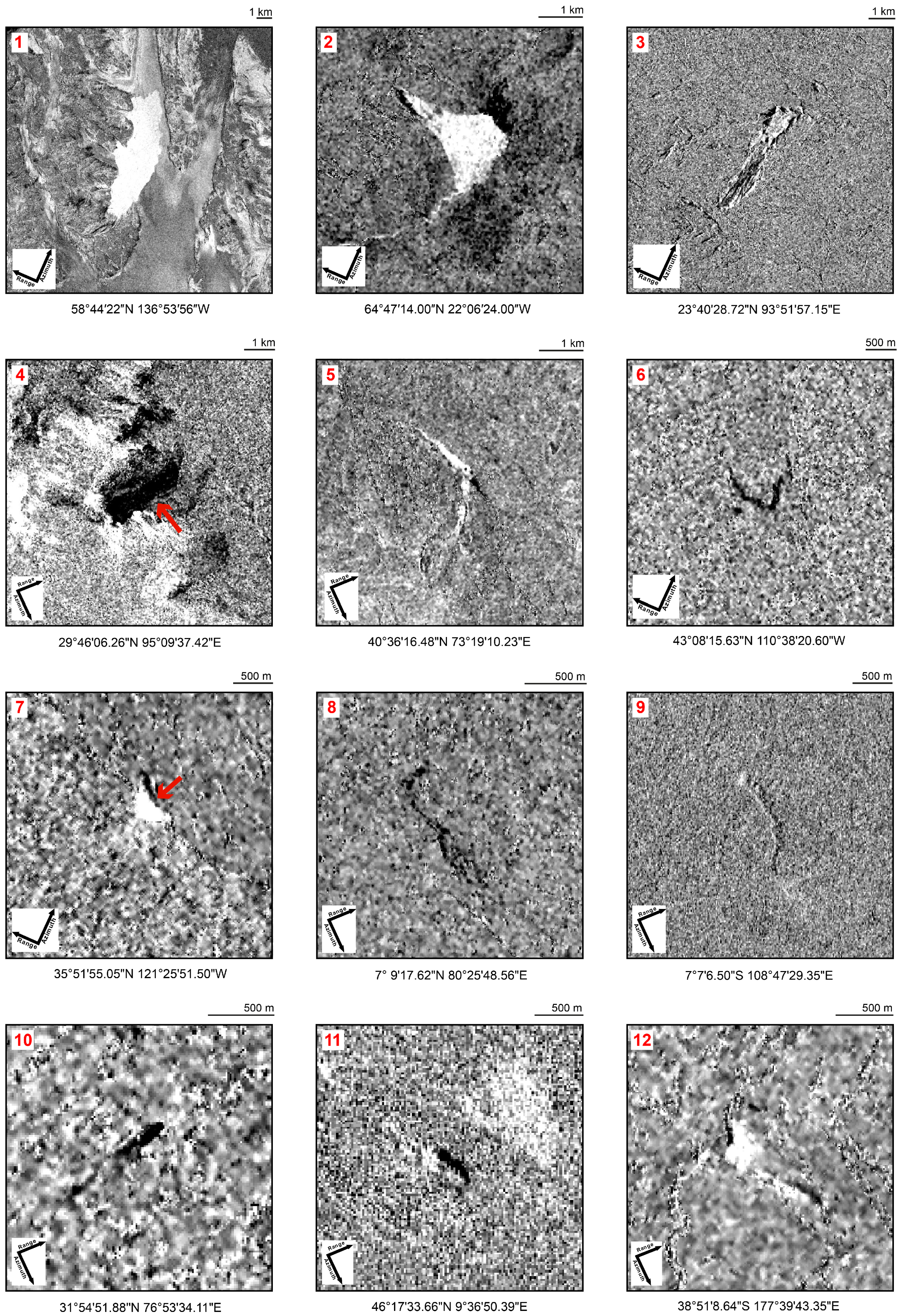
| 1 | Lamplugh glacier landslide | Alaska, USA | 28/07/2016 | Ra | U | 3 |
| 2 | Fagraskògarfjall landslide | Fagraskògarfjall, Iceland | 07/07/2018 | Df | R | 3 |
| 3 | Tonzang landslide | Chin Division, Myanmar | 18/07/2015–11/08/2015 | Es-Ef | R | 3 |
| 4 | Yarlung Tsangpo landslide | Tibet, China | 17/11/2017–25/11/2017 | Sa-Ra | E | 3 |
| 5 | Kurbu-Tash landslide | Uzgen Region, Kyrgyzstan | 29/04/2017 | Ef | RS | 3 |
| 6 | Willow Creek landslide | Wyoming, USA | 25/05/2017–06/06/2017 | Ef-Mf | U | 3 |
| 7 | Mud Creek Slide | California, USA | 20/05/2017 | Rs | U | 3 |
| 8 | Aranayake landslide | Sabaragamuwa Province, Sri Lanka | 17/05/2016 | Es-Df | R | 3 |
| 9 | Pasir Panjang landslide | Brebes, Indonesia | 22/02/2018 | Df | R | 3 |
| 10 | Kotrupi landslide | Himachal Pradesh, India | 13/08/2017 | Ds-Df | R | 3 |
| 11 | Bondo landslide | Val Bondasca Region, Switzerland | 23/08/2017 | Ra-Df | RS | 3 |
| 12 | Wairoa Landslide | North Island, New Zealand | 20/02/2018–24/02/2018 | Rs | U | 3 |
| 13 | Kaikoura landslide | South Island, New Zealand | 13/11/2016 | Sl | E | 3 |
| 14 | Bucyurabuhoro landslide | Karongi District, Rwanda | 06/05/2018 | Df-Mf | R | 3 |
| 15 | Hita landslide | Oita Prefecture, Japan | 05/07/2017 | Sl | R | 3 |
| 16 | Minamiaso landslide | Kumamoto prefecture, Japan | 16/04/2016 | Rs | E | 3 |
| 17 | Freetown landslide | Western Area, Sierra Leone | 14/08/2017 | Ef-Mf | R | 3 |
| 18 | Lai Chau landslide | Lai Chau Province, Vietnam | 26/06/2018 | Sl-Ef | R | 3 |
| 19 | Zhangjiawan landslide | Guizhou Province, China | 28/08/2017 | Rs | R | 3 |
| 20 | Shenzhen landslide | Guangdong Province, China | 20/12/2015 | Es-Ef | H | 3 |
| 21 | Kure landslides | Hiroshima prefecture, Japan | 09/07/2018 | Df | R | 3 |
| 22 | Yaglidere landslide | Giresun, Turkey | 04/02/2016 | Rs | RS | 2 |
| 23 | Salgar landslide | Antioquia Department, Colombia | 18/05/2015 | Df-Mf | R | 1 |
| 24 | Corinto landslide | Cauca Department, Colombia | 07/11/2017 | Mf | R | 1 |
| 25 | Hokkaido landslides | Hokkaido Prefecture, Japan | 06/09/2018 | Es-Ef | ER | 3 |
| 26 | Kodagu landslides | Karnataka Province, India | 14/08/2018–17/08/2018 | Es-Ef | R | 3 |
| 27 | Mocoa landslide | Putumayo Province, Colombia | 01/04/2017 | Df-Mf | R | 1 |
| 28 | Medellin landslide | Antioquia Department, Colombia | 26/10/2016 | Es-Ef | R | 1 |
| A | Maoxian landslide | Sichuan Province, China | 24/06/2017 | Ra | R | 3 |
| B | Villa Santa Lucia landslide | Los Lagos Region, Chile | 16/12/2017 | Rs-Mf | RS | 3 |
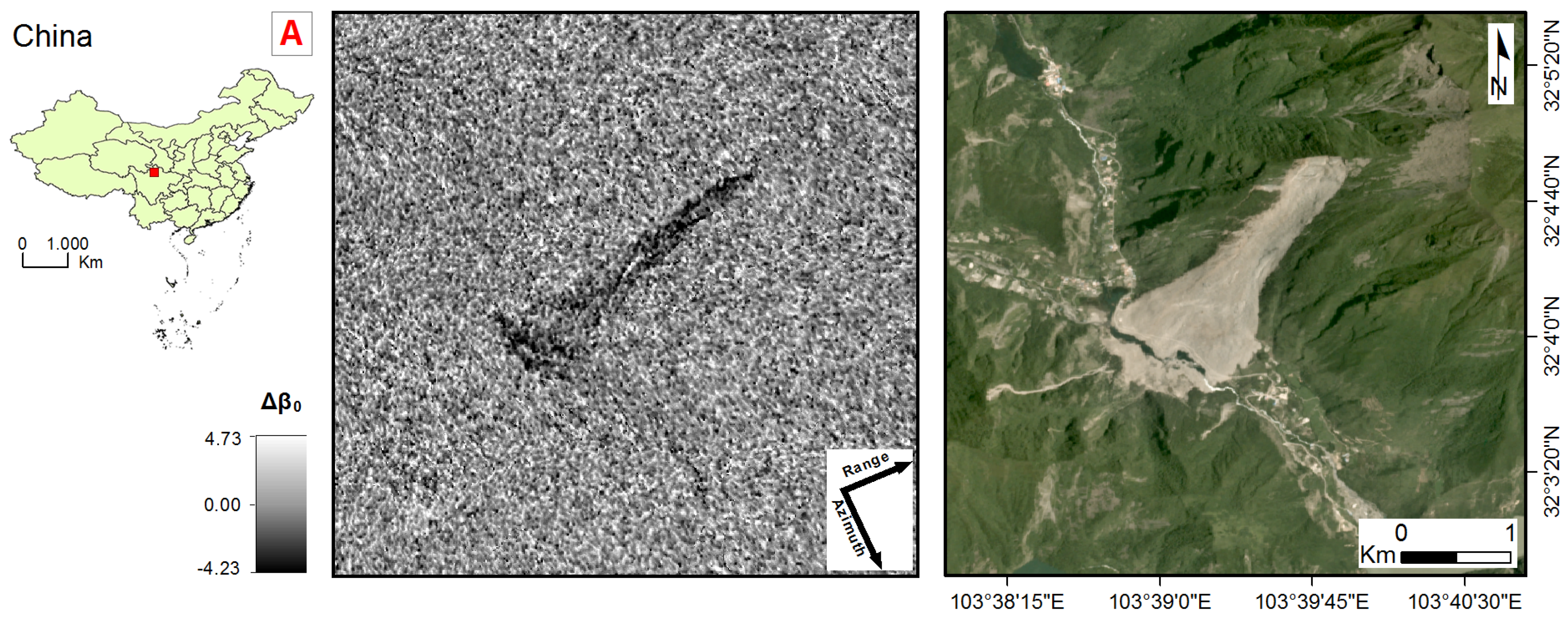
| C | Almaluu-Bulak | Suzak District, Kyrgyzstan | 27/04/2016 | Es-Ef | R | 3 |
| D | Kyzyl-Senir landslide | Suzak District, Kyrgyzstan | 10/04/2017–04/05/2017 | Es-Ef | R | 3 |
| ID | Area (Km) | Exposition | Land Cover | Slope (°) | Lithology | Climate Regime |
|---|---|---|---|---|---|---|
| 1 | 21.00 | N | Glacial | <10 | Ir | Dfc |
| 2 | 2.60 | SE | Bare | 10–15 | La | Cfc |
| 3 | 5.00 | NE | Vegetated | 10–15 | Fly | Aw |
| 4 | 2.50 | SE | Bare | >25 | Nsc | Dwb |
| 5 | 1.85 | SE | Bare | 10–15 | Uc | Dsa |
| 6 | 0.42 | SW | Vegetated | 10–15 | Fly | Dfb |
| 7 | 0.24 | SW | Bare | 15–25 | Cc | Csb |
| 8 | 0.50 | NE | Vegetated | 15–25 | Nsc | Af |
| 9 | 0.34 | SE | Vegetated | <10 | Py | Af |
| 10 | 0.15 | SW | Bare/vegetated | 15–25 | Sc | Cwa |
| 11 | 1.30 | NW | Vegetated | 15–25 | Sc-Ir | Dfb |
| 12 | 0.20 | NW | Vegetated | <10 | Fly | Cfb |
| 13 | 0.50 | SE | Vegetated | 10–15 | Fly | Cfb |
| 14 | 0.11 | SE | Vegetated | 15–25 | Fly-Mar | Aw |
| 15 | 0.26 | SE | Vegetated | 15–25 | La-Py | Cfa |
| 16 | 0.36 | SE | Vegetated | 15–25 | La-Py | Cfa |
| 17 | 0.20 | NW | Vegetated/built up | <10 | Ir | Am |
| 18 | 0.38 | SE | Vegetated | 10–15 | Car | Cwa |
| 19 | 0.26 | NW | Vegetated | 15–25 | Cc | Cwc |
| 20 | 0.25 | N | Waste dump | 10–15 | Ir | Cwa |
| 21 | 0.50 | NW | Vegetated | <10 | Py | Cfa |
| 22 | 0.006 | NW | Vegetated | >25 | Ir | Cfb |
| 23 | 0.40 | E | Vegetated/built up | <10 | Fly | Af |
| 24 | 1.00 | NW | Vegetated/built up | <10 | Uc | Am |
| 25 | 0.01 | ALL | Vegetated | 10–15 | Cc | Cfa |
| 26 | 0.30 | ALL | Vegetated | 10–15 | Uc | Cwa |
| 27 | 0.001 | ALL | Vegetated/built up | <10 | Ir | Af |
| 28 | 0.05 | W | Bare/vegetated | >25 | Nsc | Am |
| A | 1.50 | SW | Vegetated | 15–25 | Fly | Cfa |
| B | 5.00 | SE | Vegetated | <10 | Ch | Cfb |
| C | 0.18 | N | Bare | 10–15 | Uc | Dsa |
| D | 1.54 | SE | Bare | <10 | Uc | Dsa |
© 2019 by the authors. Licensee MDPI, Basel, Switzerland. This article is an open access article distributed under the terms and conditions of the Creative Commons Attribution (CC BY) license (http://creativecommons.org/licenses/by/4.0/).
Share and Cite
Mondini, A.C.; Santangelo, M.; Rocchetti, M.; Rossetto, E.; Manconi, A.; Monserrat, O. Sentinel-1 SAR Amplitude Imagery for Rapid Landslide Detection. Remote Sens. 2019, 11, 760. https://doi.org/10.3390/rs11070760
Mondini AC, Santangelo M, Rocchetti M, Rossetto E, Manconi A, Monserrat O. Sentinel-1 SAR Amplitude Imagery for Rapid Landslide Detection. Remote Sensing. 2019; 11(7):760. https://doi.org/10.3390/rs11070760
Chicago/Turabian StyleMondini, Alessandro C., Michele Santangelo, Margherita Rocchetti, Enrica Rossetto, Andrea Manconi, and Oriol Monserrat. 2019. "Sentinel-1 SAR Amplitude Imagery for Rapid Landslide Detection" Remote Sensing 11, no. 7: 760. https://doi.org/10.3390/rs11070760
APA StyleMondini, A. C., Santangelo, M., Rocchetti, M., Rossetto, E., Manconi, A., & Monserrat, O. (2019). Sentinel-1 SAR Amplitude Imagery for Rapid Landslide Detection. Remote Sensing, 11(7), 760. https://doi.org/10.3390/rs11070760