Mapping Climatological Bare Soil Albedos over the Contiguous United States Using MODIS Data


Abstract
1. Introduction
2. Materials and Methods
2.1. MODIS Albedo Anisotropy Products
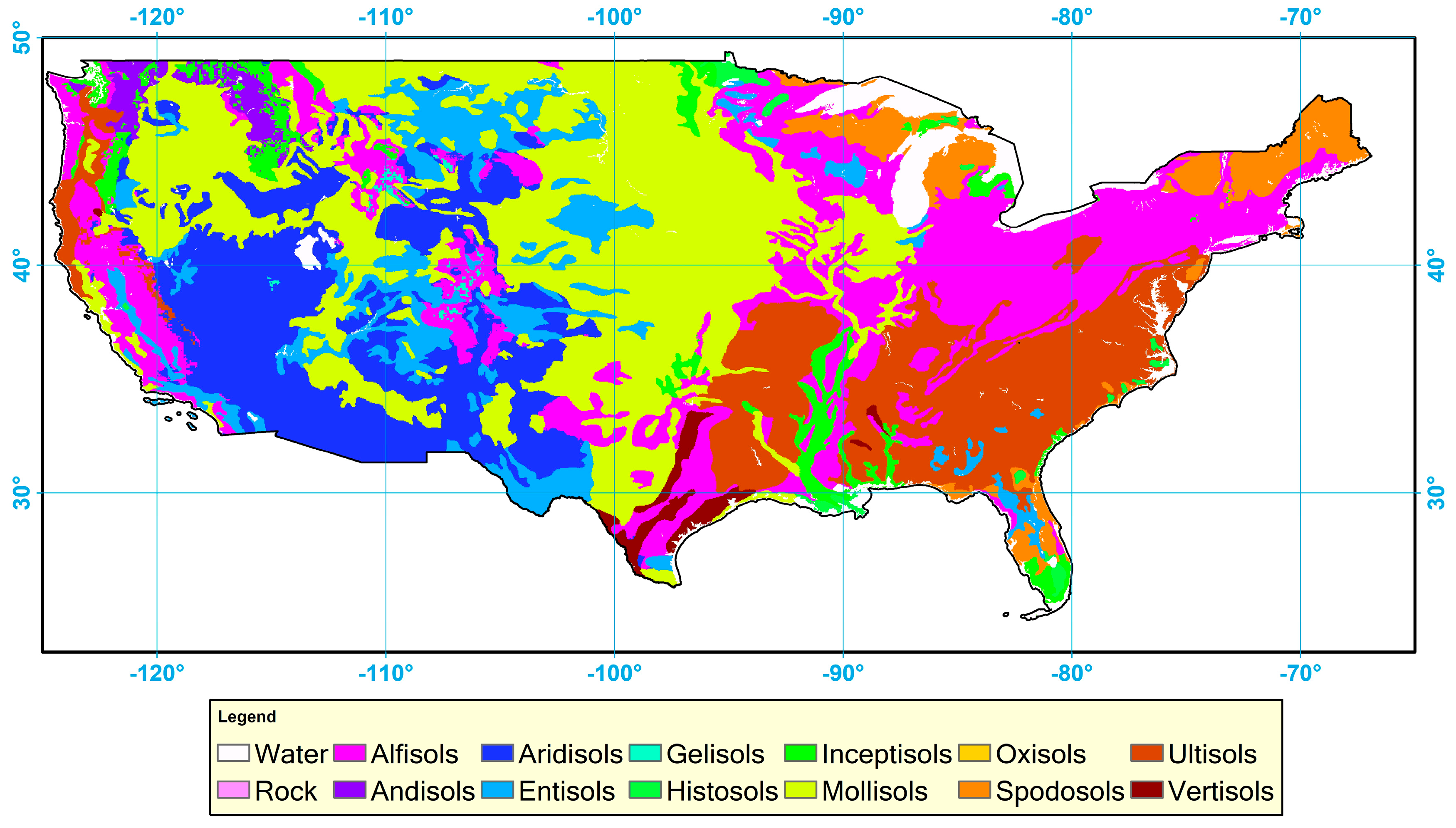
2.2. Soil Type Map
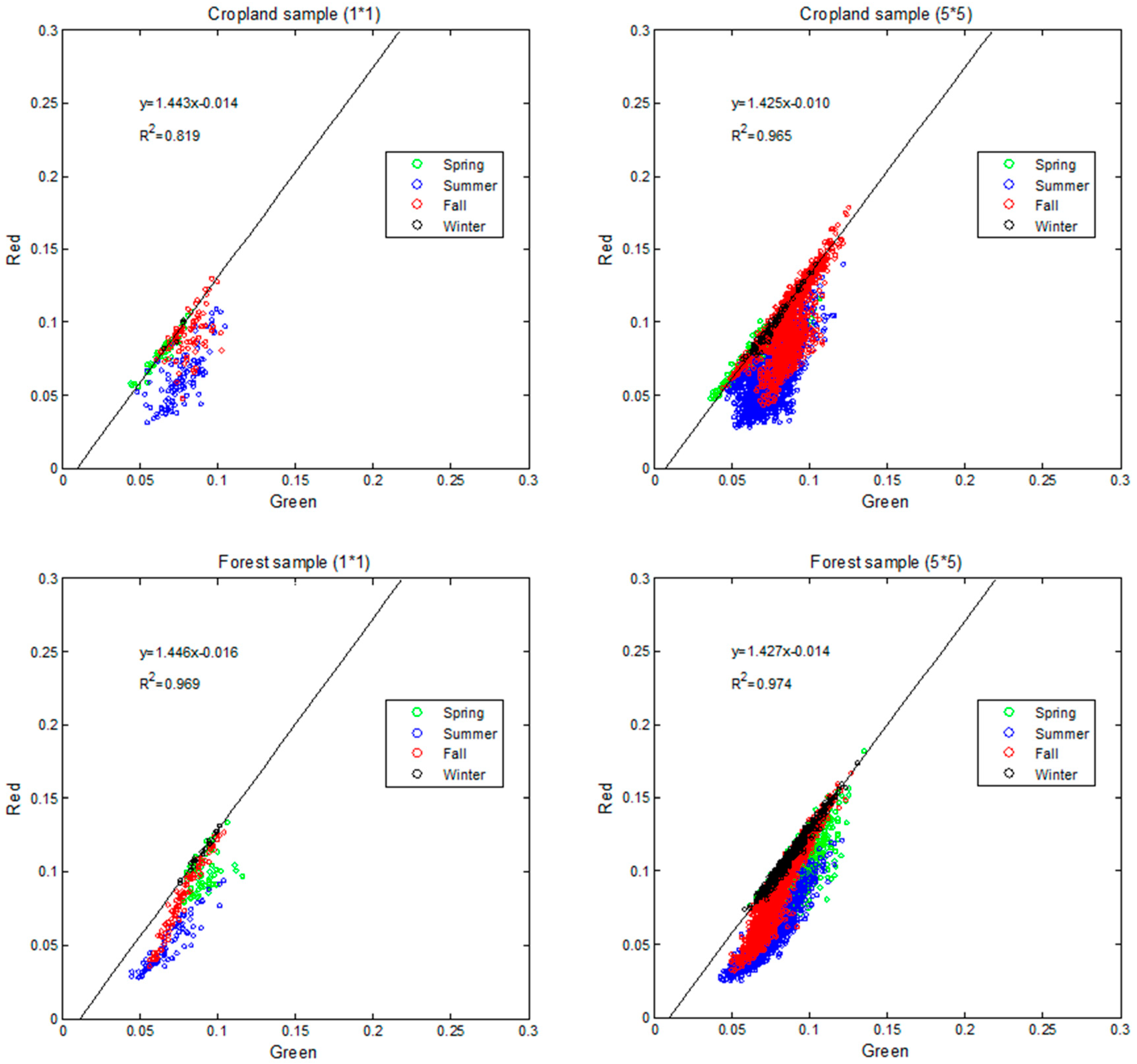
2.3. Using the Soil Line to Detect Bare Soil
3. Results and Discussion
3.1. Charateristics of Soil Lines Derived from MODIS Albedo
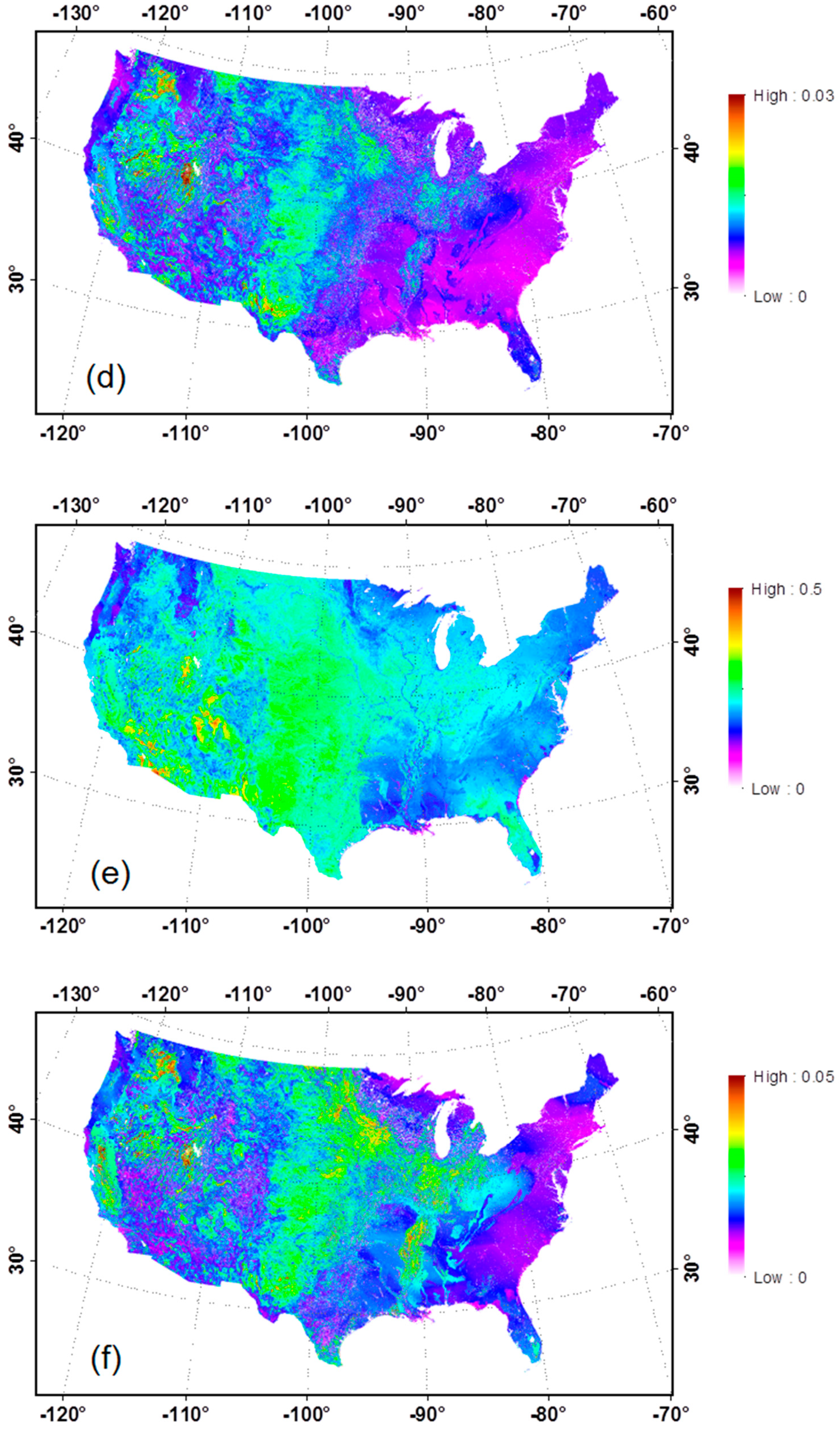
3.2. Validation of MODIS Bare Soil Albedo
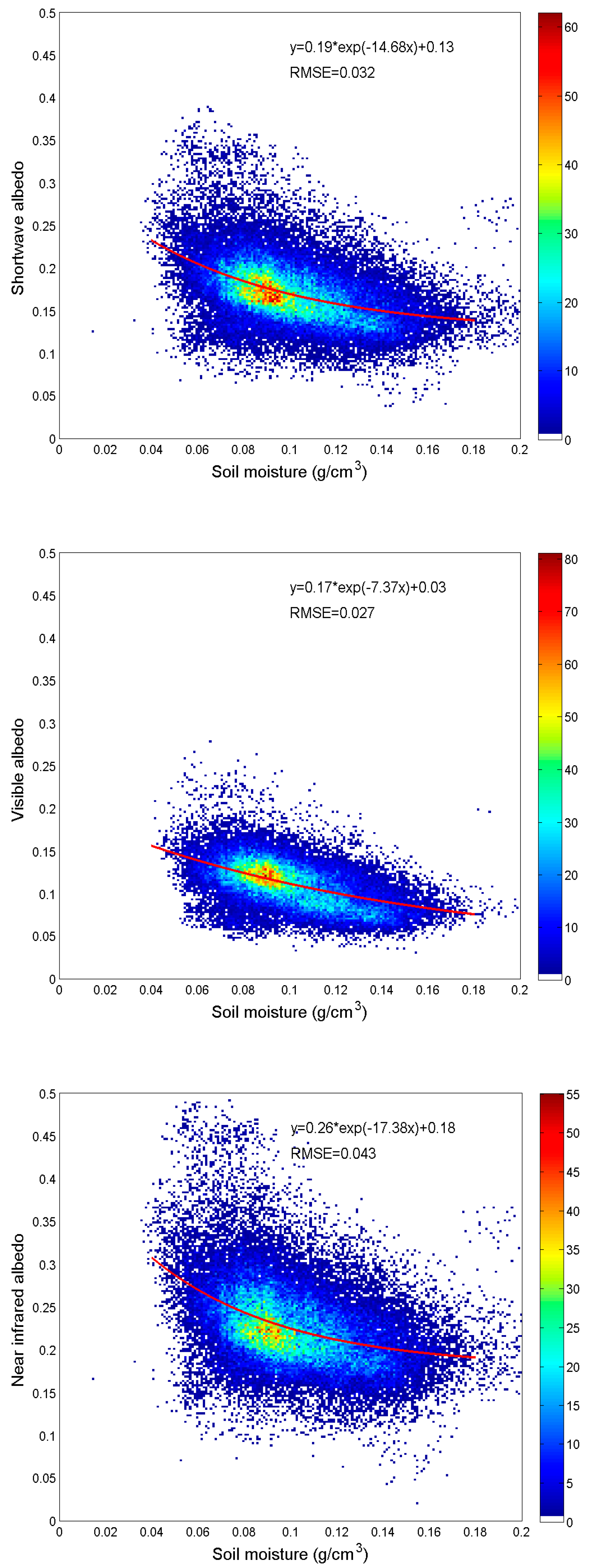
3.3. Impacts of Soil Moisture Content on Soil Albedo
3.4. Relationship of Bare Soil Albedo with Major Soil Types and Land Cover Types
4. Conclusions
Author Contributions
Acknowledgments
Conflicts of Interest
References
- Liang, S.L.; Wang, K.C.; Zhang, X.T.; Wild, M. Review on estimation of land surface radiation and energy budgets from ground measurement, remote sensing and model simulations. IEEE J. Sel. Top. Appl. Earth Obs. Remote Sens. 2010, 3, 225–240. [Google Scholar] [CrossRef]
- Liang, S.L.; Zhang, X.T.; He, T.; Cheng, J.; Wang, D. Remote sensing of the land surface radiation budget. In Remote Sensing of Energy Fluxes and Soil Moisture Content; CRC Press: Boca Raton, FL, USA, 2013; pp. 121–162. [Google Scholar] [CrossRef]
- Ganguly, S.; Nemani, R.R.; Zhang, G.; Hashimoto, H.; Milesi, C.; Michaelis, A.; Wang, W.L.; Votava, P.; Samanta, A.; Melton, F.; et al. Generating global Leaf Area Index from Landsat: Algorithm formulation and demonstration. Remote Sens. Environ. 2012, 122, 185–202. [Google Scholar] [CrossRef]
- Myneni, R.B.; Hoffman, S.; Knyazikhin, Y.; Privette, J.L.; Glassy, J.; Tian, Y.; Wang, Y.; Song, X.; Zhang, Y.; Smith, G.R.; et al. Global products of vegetation leaf area and fraction absorbed PAR from year one of MODIS data. Remote Sens. Environ. 2002, 83, 214–231. [Google Scholar] [CrossRef]
- Dickinson, R.E.; Henderson-Sellers, A.; Kennedy, P.J. Biosphere-Atmosphere Transfer Scheme (BATS) version 1e as coupled to the NCAR Community Climate Model. NCAR Technical Note NCAR/TN-387+STR; National Center for Atmospheric Research: Boulder, CO, USA, 1993. [Google Scholar]
- Bonan, G.B. A Land Surface Model (LSM Version 1.0) for Ecological, Hydrological, and Atmospheric Studies: Technical Description and User’s Guide. NCAR Technical Note NCAR/TN-417+STR; National Center for Atmospheric Research: Boulder, CO, USA, 1996. [Google Scholar]
- Post, D.F.; Fimbres, A.; Matthias, A.D.; Sano, E.E.; Accioly, L.; Batchily, A.K.; Ferreira, L.G. Predicting soil albedo from soil color and spectral reflectance data. Soil Sci. Soc. Am. J. 2000, 64, 1027–1034. [Google Scholar] [CrossRef]
- Liu, H.Z.; Wang, B.M.; Fu, C.B. Relationships between surface albedo, soil thermal parameters and soil moisture in the semi-arid area of Tongyu, Northeastern China. Adv. Atmos. Sci. 2008, 25, 757–764. [Google Scholar] [CrossRef]
- Gascoin, S.; Ducharne, A.; Ribstein, P.; Perroy, E.; Wagnon, P. Sensitivity of bare soil albedo to surface soil moisture on the moraine of the Zongo glacier (Bolivia). Geophys. Res. Lett. 2009, 36, L02405. [Google Scholar] [CrossRef]
- Irons, J.R.; Ranson, K.J.; Daughtry, C.S.T. Estimating big bluestem albedo from directional reflectance measurements. Remote Sens. Environ. 1988, 25, 185–199. [Google Scholar] [CrossRef]
- Matthias, A.D.; Fimbres, A.; Sano, E.E.; Post, D.F.; Accioly, L.; Batchily, A.K.; Ferreira, L.G. Surface roughness effects on soil albedo. Soil Sci. Soc. Am. J. 2000, 64, 1035–1041. [Google Scholar] [CrossRef]
- Zhou, L.; Dickinson, R.E.; Tian, Y.; Zeng, X.; Dai, Y.; Yang, Z.L.; Schaaf, C.B.; Gao, F.; Jin, Y.; Strahler, A.; et al. Comparison of seasonal and spatial variations of albedos from Moderate-Resolution Imaging Spectroradiometer (MODIS) and Common Land Model. J. Geophys. Res.-Atmos. 2003, 108. [Google Scholar] [CrossRef]
- Kala, J.; Evans, J.P.; Pitman, A.J.; Schaaf, C.B.; Decker, M.; Carouge, C.; Mocko, D.; Sun, Q. Implementation of a soil albedo scheme in the CABLEv1.4b land surface model and evaluation against MODIS estimates over Australia. Geosci. Model Dev. 2014, 7, 2121–2140. [Google Scholar] [CrossRef]
- Fensholt, R.; Sandholt, I.; Rasmussen, M.S. Evaluation of MODIS LAI, fAPAR and the relation between fAPAR and NDVI in a semi-arid environment using in situ measurements. Remote Sens. Environ. 2004, 91, 490–507. [Google Scholar] [CrossRef]
- Weiss, M.; Baret, F.; Garrigues, S.; Lacaze, R. LAI and fAPAR CYCLOPES global products derived from VEGETATION. Part 2: validation and comparison with MODIS collection 4 products. Remote Sens. Environ. 2007, 110, 317–331. [Google Scholar] [CrossRef]
- Pisek, J.; Chen, J.M. Mapping forest background reflectivity over North America with Multi-angle Imaging SpectroRadiometer (MISR) data. Remote Sens. Environ. 2009, 113, 2412–2423. [Google Scholar] [CrossRef]
- Pinty, B.; Clerici, M.; Andredakis, I.; Kaminski, T.; Taberner, M.; Verstraete, M.M.; Gobron, N.; Plummer, S.; Widlowski, J.L. Exploiting the MODIS albedos with the Two-stream Inversion Package (JRC-TIP): 2. Fractions of transmitted and absorbed fluxes in the vegetation and soil layers. J. Geophys. Res.-Atmos. 2011, 116. [Google Scholar] [CrossRef]
- Gascoin, S.; Ducharne, A.; Ribstein, P.; Lejeune, Y.; Wagnon, P. Dependence of bare soil albedo on soil moisture on the moraine of the Zongo glacier (Bolivia): Implications for land surface modeling. J. Geophys. Res.-Atmos. 2009, 114. [Google Scholar] [CrossRef]
- Zhou, L.M.; Dickinson, R.E.; Tian, Y.H. Derivation of a soil albedo dataset from MODIS using principal component analysis: Northern Africa and the Arabian Peninsula. Geophys. Res. Lett. 2005, 32. [Google Scholar] [CrossRef]
- Liang, X.Z.; Xu, M.; Gao, W.; Kunkel, K.; Slusser, J.; Dai, Y.J.; Min, Q.L.; Houser, P.R.; Rodell, M.; Schaaf, C.B.; et al. Development of land surface albedo parameterization based on Moderate Resolution Imaging Spectroradiometer (MODIS) data. J. Geophys. Res.-Atmos. 2005, 110. [Google Scholar] [CrossRef]
- Houldcroft, C.J.; Grey, W.M.F.; Barnsley, M.; Taylor, C.M.; Los, S.O.; North, P.R.J. New vegetation albedo parameters and global fields of soil background albedo derived from MODIS for use in a climate model. J. Hydrometeorol. 2009, 10, 183–198. [Google Scholar] [CrossRef]
- Jasinski, M.F. Sensitivity of the normalized difference vegetation index to subpixel canopy cover, soil albedo, and pixel scale. Remote Sens. Environ. 1990, 32, 169–187. [Google Scholar] [CrossRef]
- Pettorelli, N.; Vik, J.O.; Mysterud, A.; Gaillard, J.M.; Tucker, C.J.; Stenseth, N.C. Using the satellite-derived NDVI to assess ecological responses to environmental change. Trends Ecol. Evol. 2005, 20, 503–510. [Google Scholar] [CrossRef]
- Kaptue, T.A.T.; Roujean, J.L.; Faroux, S. ECOCLIMAP-II: An ecosystem classification and land surface parameters database of Western Africa at 1 km resolution for the African Monsoon Multidisciplinary Analysis (AMMA) project. Remote Sens. Environ. 2010, 114, 961–976. [Google Scholar] [CrossRef]
- Rechid, D.; Raddatz, T.; Jacob, D. Parameterization of snow-free land surface albedo as a function of vegetation phenology based on MODIS data and applied in climate modelling. Theor. Appl. Climatol. 2009, 95, 245–255. [Google Scholar] [CrossRef]
- Carrer, D.; Meurey, C.; Ceamanos, X.; Roujean, J.-L.; Calvet, J.-C.; Liu, S. Dynamic mapping of snow-free vegetation and bare soil albedos at global 1 km scale from 10-year analysis of MODIS satellite products. Remote Sens. Environ. 2014, 140, 420–432. [Google Scholar] [CrossRef]
- Anderson, M.C.; Kustas, W.P.; Alfieri, J.G.; Gao, F.; Hain, C.; Prueger, J.H.; Evett, S.; Colaizzi, P.; Howell, T.; Chavez, J.L. Mapping daily evapotranspiration at Landsat spatial scales during the BEAREX’08 field campaign. Adv. Water Resour. 2012, 50, 162–177. [Google Scholar] [CrossRef]
- Lobell, D.B.; Asner, G.P. Moisture effects on soil reflectance. Soil Sci. Soc. Am. J. 2002, 66, 722–727. [Google Scholar] [CrossRef]
- Liu, W.D.; Baret, F.; Gu, X.F.; Tong, Q.X.; Zheng, L.F.; Zhang, B. Relating soil surface moisture to reflectance. Remote Sens. Environ. 2002, 81, 238–246. [Google Scholar]
- Wang, K.C.; Wang, P.C.; Liu, J.M.; Sparrow, M.; Haginoya, S.; Zhou, X.J. Variation of surface albedo and soil thermal parameters with soil moisture content at a semi-desert site on the western Tibetan Plateau. Bound.-Layer Meteorol. 2005, 116, 117–129. [Google Scholar] [CrossRef]
- Guan, X.D.; Huang, J.P.; Guo, N.; Bi, J.R.; Wang, G.Y. Variability of soil moisture and its relationship with surface albedo and soil thermal parameters over the Loess Plateau. Adv. Atmos. Sci. 2009, 26, 692–700. [Google Scholar] [CrossRef]
- Liu, S.; Roujean, J.-L.; Kaptue Tchuente, A.T.; Ceamanos, X.; Calvet, J.-C. A parameterization of SEVIRI and MODIS daily surface albedo with soil moisture: Calibration and validation over southwestern France. Remote Sens. Environ. 2014, 144, 137–151. [Google Scholar] [CrossRef]
- Guerschman, J.P.; Scarth, P.F.; McVicar, T.R.; Renzullo, L.J.; Malthus, T.J.; Stewart, J.B.; Rickards, J.E.; Trevithick, R. Assessing the effects of site heterogeneity and soil properties when unmixing photosynthetic vegetation, non-photosynthetic vegetation and bare soil fractions from Landsat and MODIS data. Remote Sens. Environ. 2015, 161, 12–26. [Google Scholar] [CrossRef]
- Baret, F.; Jacquemoud, S.; Hanocq, J.F. About the soil line concept in remote sensing. Adv. Space Res. 1993, 13, 281–284. [Google Scholar] [CrossRef]
- Gitelson, A.A.; Stark, R.; Grits, U.; Rundquist, D.; Kaufman, Y.; Derry, D. Vegetation and soil lines in visible spectral space: a concept and technique for remote estimation of vegetation fraction. Int. J. Remote Sens. 2002, 23, 2537–2562. [Google Scholar] [CrossRef]
- Huete, A.R. A Soil-Adjusted Vegetation Index (SAVI). Remote Sens. Environ. 1988, 25, 295–309. [Google Scholar] [CrossRef]
- Pickup, G.; Chewings, V.H.; Nelson, D.J. Estimating changes in vegetation cover over time in arid rangelands using Landsat MSS data. Remote Sens. Environ. 1993, 43, 243–263. [Google Scholar] [CrossRef]
- Cui, S.; Rajan, N.; Maas, S.J.; Youn, E. An automated soil line identification method using relevance vector machine. Remote Sens. Lett. 2014, 5, 175–184. [Google Scholar] [CrossRef]
- Fox, G.A.; Sabbagh, G.J.; Searcy, S.W.; Yang, C. An automated soil line identification routine for remotely sensed images. Soil Sci. Soc. Am. J. 2004, 68, 1326–1331. [Google Scholar] [CrossRef]
- Schaaf, C.; Wang, Z. MCD43A1 MODIS/Terra+Aqua BRDF/Albedo Model Parameters Daily L3 Global-500m V006; NASA EOSDIS Land Processes DAAC: Sioux Falls, SD, USA, 2015. [CrossRef]
- Gao, B.C. NDWI - A normalized difference water index for remote sensing of vegetation liquid water from space. Remote Sens. Environ. 1996, 58, 257–266. [Google Scholar] [CrossRef]
- Lawrence, P.J.; Chase, T.N. Representing a new MODIS consistent land surface in the Community Land Model (CLM 3.0). J. Geophys. Res.-Biogeosci. 2007, 112. [Google Scholar] [CrossRef]
- USDA. Soil Taxonomy: A Basic System of Soil Classification for Making and Interpreting Soil Survey, 2nd ed.; U.S. Department of Agriculture Handbook 436; Soil Survey Staff, Ed.; Natural Resources Conservation Service: Washington, DC, USA, 1999.
- Baldridge, A.M.; Hook, S.J.; Grove, C.I.; Rivera, G. The ASTER spectral library version 2.0. Remote Sens. Environ. 2009, 113, 711–715. [Google Scholar] [CrossRef]
- Clark, R.N.; Swayze, G.A.; Wise, R.; Livo, E.; Hoefen, T.; Kokaly, R.; Sutley, S.J. USGS digital spectral library splib06a. U.S. Geol. Surv. Digit. Data Ser. 231 2007. [Google Scholar]
- Nguy-Robertson, A.; Gitelson, A.; Peng, Y.; Walter-Shea, E.; Leavitt, B.; Arkebauer, T. Continuous monitoring of crop reflectance, vegetation fraction, and identification of developmental stages using a four band radiometer. Agron. J. 2013, 105, 1769–1779. [Google Scholar] [CrossRef]
- Gitelson, A.A.; Gritz, Y.; Merzlyak, M.N. Relationships between leaf chlorophyll content and spectral reflectance and algorithms for non-destructive chlorophyll assessment in higher plant leaves. J. Plant Physiol. 2003, 160, 271–282. [Google Scholar] [CrossRef]
- He, T.; Liang, S.L.; Wang, D.; Shuai, Y.; Yu, Y. Fusion of satellite land surface albedo products across scales using a multiresolution tree method in the north central United States. IEEE Trans. Geosci. Remote Sens. 2014, 52, 3428–3439. [Google Scholar] [CrossRef]
- Masek, J.G.; Vermote, E.F.; Saleous, N.E.; Wolfe, R.; Hall, F.G.; Huemmrich, K.F.; Gao, F.; Kutler, J.; Lim, T.K. A Landsat surface reflectance dataset for North America, 1990–2000. IEEE Geosci. Remote Sens. Lett. 2006, 3, 68–72. [Google Scholar] [CrossRef]
- Fry, J.A.; Xian, G.; Jin, S.M.; Dewitz, J.A.; Homer, C.G.; Yang, L.M.; Barnes, C.A.; Herold, N.D.; Wickham, J.D. Completion of the 2006 National Land Cover Database for the Conterminous United States. Photogramm. Eng. Remote Sens. 2011, 77, 858–864. [Google Scholar]
- Njoku, E.G.; Jackson, T.J.; Lakshmi, V.; Chan, T.K.; Nghiem, S.V. Soil moisture retrieval from AMSR-E. IEEE Trans. Geosci. Remote Sens. 2003, 41, 215–229. [Google Scholar] [CrossRef]
- Njoku, E.G.; Chan, S.K. Vegetation and surface roughness effects on AMSR-E land observations. Remote Sens. Environ. 2006, 100, 190–199. [Google Scholar] [CrossRef]
- Eltahir, E.A.B. A soil moisture rainfall feedback mechanism 1. Theory and observations. Water Resour. Res. 1998, 34, 765–776. [Google Scholar] [CrossRef]
- Liu, Z.; Notaro, M.; Gallimore, R. Indirect vegetation-soil moisture feedback with application to Holocene North Africa climate. Glob. Chang. Biol. 2010, 16, 1733–1743. [Google Scholar] [CrossRef]
- Tao, X.; Liang, S.L.; He, T.; Jin, H.R. Estimation of fraction of absorbed photosynthetically active radiation from multiple satellite data: Model development and validation. Remote Sens. Environ. 2016, 184, 539–557. [Google Scholar] [CrossRef]


| Variable | Dataset | Temporal Coverage | Spatial Resolution |
|---|---|---|---|
| Surface albedo | MCD43A | 2001–2012 | 500 m |
| Soil type | Natural Resources Conservation Service (NRCS) soil suborder map | N/A | 4000 m |
| Land cover | MCD12Q | 2006 | 500 m |
| Land cover | National Land Cover Dataset (NLCD) | 2006 | 30 m |
| Soil moisture | AMSR-E L3 | 2002–2011 | 25 km |
| Soil Type | Soil Line: | ||||
|---|---|---|---|---|---|
| a | b | R2 | RMSE | N of Pixels | |
| Alfisols | 1.4830 ± 0.0057 | −0.0142 ± 0.0006 | 0.8407 | 0.0114 | 190525 |
| Andisols | 1.3557 ± 0.0075 | −0.0053 ± 0.0008 | 0.9393 | 0.0063 | 16682 |
| Aridisols | 1.3394 ± 0.0014 | −0.0028 ± 0.0002 | 0.9047 | 0.0132 | 134894 |
| Entisols | 1.3195 ± 0.0016 | −0.0027 ± 0.0002 | 0.9223 | 0.0112 | 99206 |
| Gelisols | 1.3058 ± 0.0599 | −0.0053 ± 0.0053 | 0.9888 | 0.0024 | 1472 |
| Histosols | 1.2052 ± 0.0204 | −0.0062 ± 0.0014 | 0.9400 | 0.0070 | 8340 |
| Inceptisols | 1.3661 ± 0.0089 | −0.0116 ± 0.0016 | 0.9145 | 0.0084 | 43997 |
| Mollisols | 1.3242 ± 0.0014 | −0.0017 ± 0.0002 | 0.9209 | 0.0077 | 262389 |
| Oxisols | 1.0827 ± 0.1283 | 0.0139 ± 0.0107 | 0.9394 | 0.0056 | 457 |
| Spodosols | 1.2062 ± 0.0265 | −0.0101 ± 0.0019 | 0.9559 | 0.0086 | 120682 |
| Ultisols | 1.4115 ± 0.0088 | −0.0177 ± 0.0007 | 0.9449 | 0.0079 | 105382 |
| Vertisols | 1.2849 ± 0.0082 | −0.0030 ± 0.0008 | 0.9017 | 0.0067 | 15343 |
| Soil Type | Visible | Near Infrared | Shortwave | |||
|---|---|---|---|---|---|---|
| Mean | SDEV | Mean | SDEV | Mean | SDEV | |
| Alfisols | 0.0796 | 0.0152 | 0.2060 | 0.0375 | 0.1479 | 0.0251 |
| Andisols | 0.0738 | 0.0190 | 0.1914 | 0.0457 | 0.1382 | 0.0314 |
| Aridisols | 0.1196 | 0.0376 | 0.2493 | 0.0553 | 0.1858 | 0.0433 |
| Entisols | 0.1013 | 0.0295 | 0.2330 | 0.0449 | 0.1695 | 0.0345 |
| Gelisols | 0.0801 | 0.0159 | 0.1804 | 0.0322 | 0.1357 | 0.0227 |
| Histosols | 0.0619 | 0.0158 | 0.1604 | 0.0465 | 0.1174 | 0.0299 |
| Inceptisols | 0.0704 | 0.0170 | 0.1820 | 0.0449 | 0.1310 | 0.0296 |
| Mollisols | 0.0915 | 0.0160 | 0.2258 | 0.0327 | 0.1623 | 0.0230 |
| Oxisols | 0.0674 | 0.0157 | 0.2138 | 0.0427 | 0.1460 | 0.0258 |
| Spodosols | 0.0691 | 0.0183 | 0.1702 | 0.0462 | 0.1257 | 0.0304 |
| Ultisols | 0.0739 | 0.0179 | 0.2004 | 0.0486 | 0.1429 | 0.0320 |
| Vertisols | 0.0800 | 0.0112 | 0.2248 | 0.0261 | 0.1550 | 0.0167 |
| Soil Type | Andisols | Aridisols | Entisols | Gelisols | Histosols | Inceptisols | Mollisols | Oxisols | Spodosols | Ultisols | Vertisols |
|---|---|---|---|---|---|---|---|---|---|---|---|
| Alfisols | *** | *** | *** | 0.78 | *** | *** | *** | 0.39 | *** | *** | *** |
| Andisols | *** | *** | *** | *** | *** | *** | 0.55 | ** | *** | *** | |
| Aridisols | *** | *** | *** | *** | *** | 0.36 | *** | *** | 0.40 | ||
| Entisols | 0.66 | *** | *** | *** | 0.40 | *** | *** | *** | |||
| Gelisols | *** | *** | 0.31 | 0.34 | *** | *** | *** | ||||
| Histosols | 0.28 | *** | 0.49 | *** | *** | *** | |||||
| Inceptisols | *** | 0.49 | *** | *** | *** | ||||||
| Mollisols | 0.39 | *** | *** | *** | |||||||
| Oxisols | 0.52 | 0.38 | 0.35 | ||||||||
| Spodosols | *** | *** | |||||||||
| Ultisols | * |
| IGBP Land Cover | Visible | Near Infrared | Shortwave | |||
|---|---|---|---|---|---|---|
| Mean | SDEV | Mean | SDEV | Mean | SDEV | |
| ENF | 0.0458 | 0.0147 | 0.1122 | 0.0296 | 0.0847 | 0.0210 |
| EBF | 0.0526 | 0.0193 | 0.1237 | 0.0460 | 0.0938 | 0.0304 |
| DNF | 0.0593 | 0.0139 | 0.1308 | 0.0272 | 0.1006 | 0.0191 |
| DBF | 0.0633 | 0.0124 | 0.1627 | 0.0265 | 0.1192 | 0.0184 |
| MIX | 0.0541 | 0.0134 | 0.1354 | 0.0330 | 0.1009 | 0.0222 |
| CSH | 0.0664 | 0.0161 | 0.1692 | 0.0334 | 0.1217 | 0.0234 |
| OSH | 0.1096 | 0.0315 | 0.2386 | 0.0512 | 0.1764 | 0.0393 |
| WSV | 0.0669 | 0.0142 | 0.1780 | 0.0338 | 0.1283 | 0.0234 |
| SAV | 0.0723 | 0.0144 | 0.1911 | 0.0368 | 0.1366 | 0.0252 |
| GRA | 0.0987 | 0.0192 | 0.2318 | 0.0341 | 0.1682 | 0.0245 |
| WET | 0.0489 | 0.0135 | 0.1081 | 0.0301 | 0.0847 | 0.0204 |
| CRO | 0.0893 | 0.0136 | 0.2255 | 0.0311 | 0.1610 | 0.0218 |
| URB | 0.0868 | 0.0191 | 0.1937 | 0.0324 | 0.1428 | 0.0238 |
| CRC | 0.0814 | 0.0127 | 0.2090 | 0.0291 | 0.1504 | 0.0200 |
| GLA | 0.0925 | 0.0519 | 0.1590 | 0.0663 | 0.1290 | 0.0548 |
| BRN | 0.1939 | 0.0551 | 0.3267 | 0.0813 | 0.2561 | 0.0627 |
© 2019 by the authors. Licensee MDPI, Basel, Switzerland. This article is an open access article distributed under the terms and conditions of the Creative Commons Attribution (CC BY) license (http://creativecommons.org/licenses/by/4.0/).
Share and Cite
He, T.; Gao, F.; Liang, S.; Peng, Y. Mapping Climatological Bare Soil Albedos over the Contiguous United States Using MODIS Data. Remote Sens. 2019, 11, 666. https://doi.org/10.3390/rs11060666
He T, Gao F, Liang S, Peng Y. Mapping Climatological Bare Soil Albedos over the Contiguous United States Using MODIS Data. Remote Sensing. 2019; 11(6):666. https://doi.org/10.3390/rs11060666
Chicago/Turabian StyleHe, Tao, Feng Gao, Shunlin Liang, and Yi Peng. 2019. "Mapping Climatological Bare Soil Albedos over the Contiguous United States Using MODIS Data" Remote Sensing 11, no. 6: 666. https://doi.org/10.3390/rs11060666
APA StyleHe, T., Gao, F., Liang, S., & Peng, Y. (2019). Mapping Climatological Bare Soil Albedos over the Contiguous United States Using MODIS Data. Remote Sensing, 11(6), 666. https://doi.org/10.3390/rs11060666