High-Resolution Spaceborne, Airborne and In Situ Landslide Kinematic Measurements of the Slumgullion Landslide in Southwest Colorado


Abstract

1. Introduction
2. Data and Methods
2.1. In Situ GNSS
2.2. Dense Pixel Offsets
2.2.1. High-Resolution SAR
2.2.2. Lidar-Derived Shaded Relief
2.2.3. UAS-Derived Shaded Relief
3. Results
3.1. In Situ GNSS
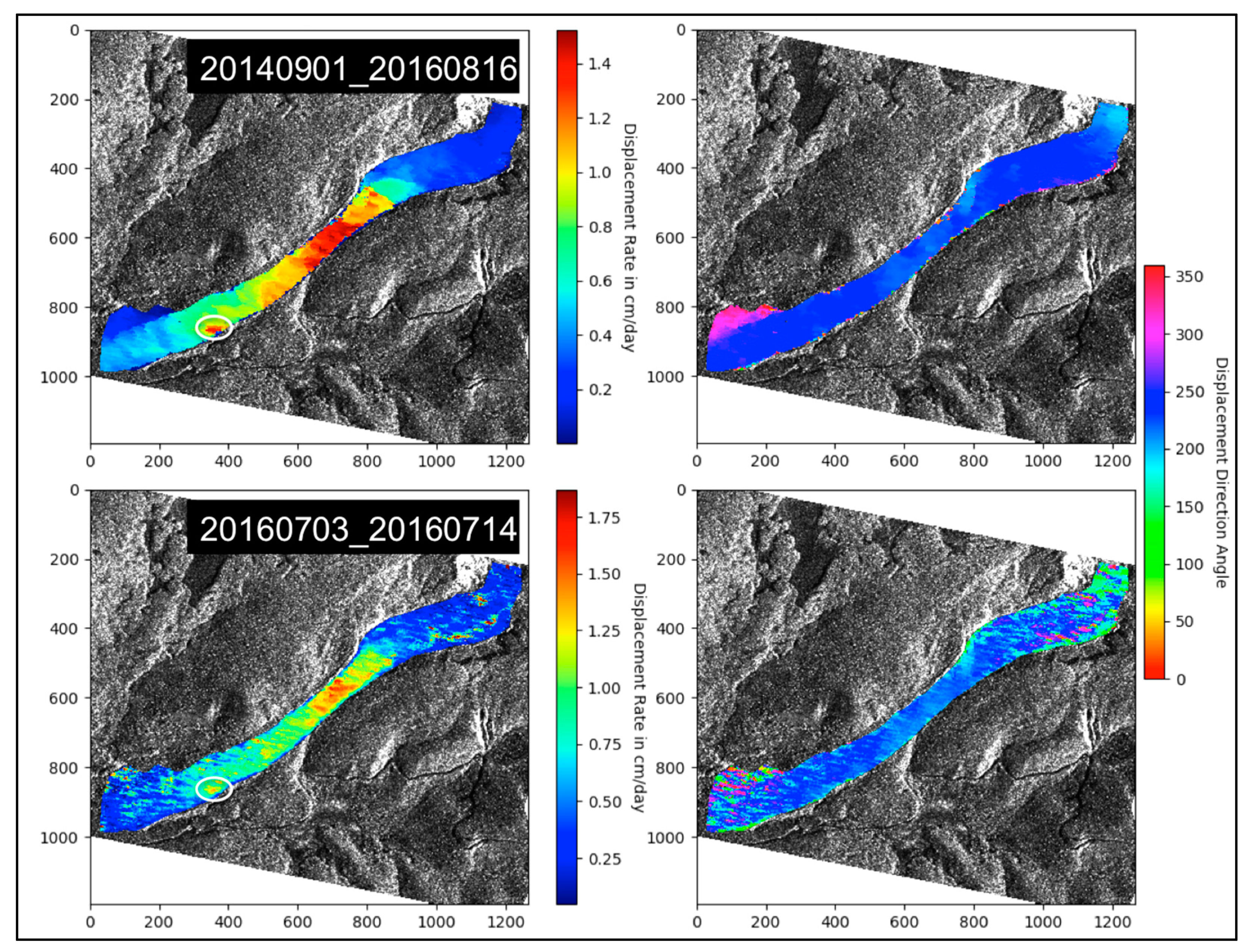
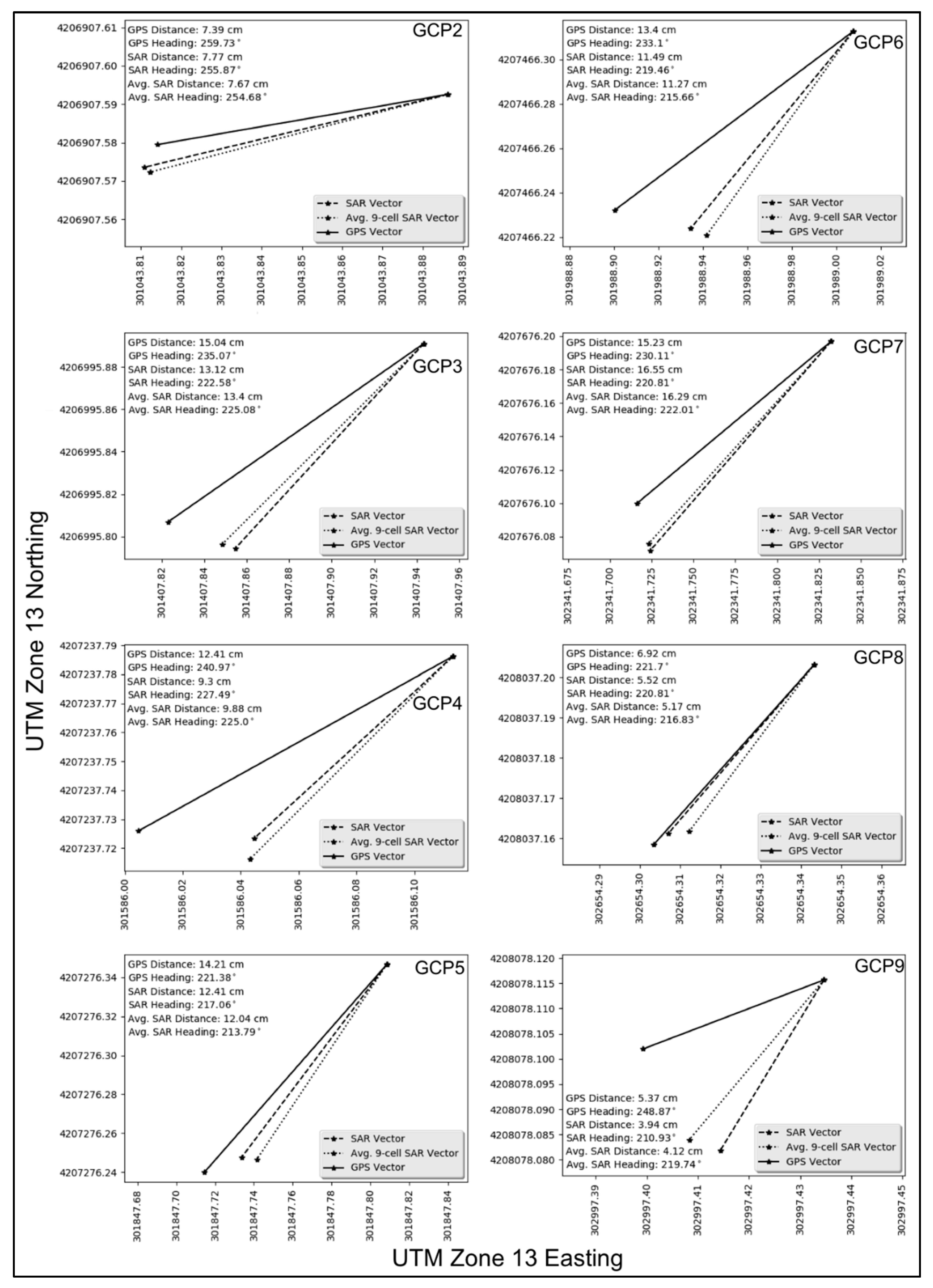
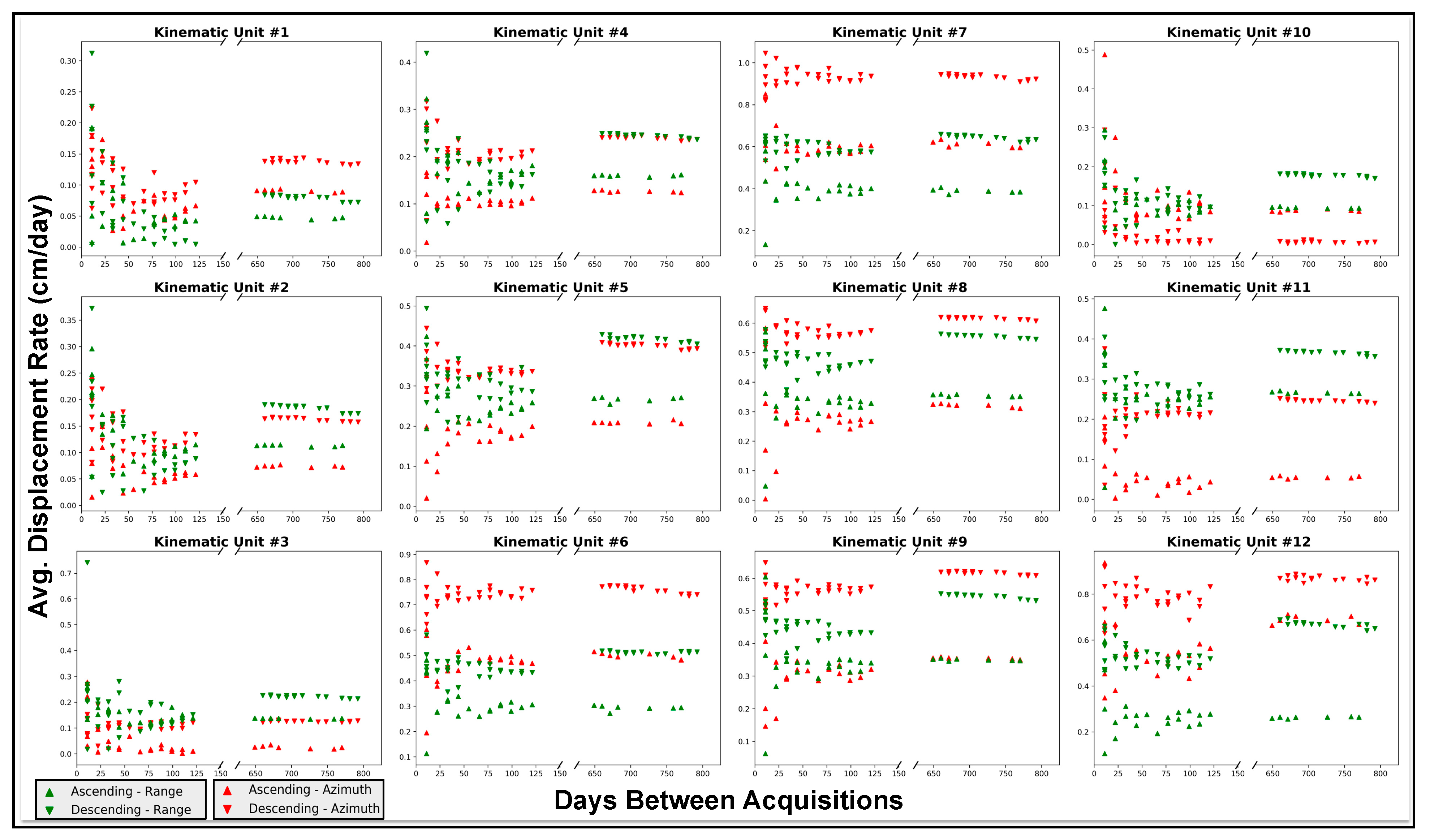
3.2. SAR Offsets
3.3. Lidar/UAS Offsets
4. Discussion
5. Conclusions
Supplementary Materials
Author Contributions
Funding
Acknowledgments
Conflicts of Interest
References
- Varnes, D.J.; Savage, W.Z. The Slumgullion Earth Flow; a Large-Scale Natural Laboratory; USGPO: Washington, DC, USA, 1996.
- Parise, M.; Guzzi, R. Volume and Shape of the Active and Inactive Parts of the Slumgullion Landslide, Hinsdale County, Colorado; US Geological Survey: Reston, VI, USA, 1992.
- Fleming, R.W.; Baum, R.L.; Giardino, M. Map and Description of the Active Part of the Slumgullion Landslide, Hinsdale County, Colorado; US Department of the Interior, US Geological Survey: Reston, VI, USA, 1999.
- Parise, M. Observation of surface features on an active landslide, and implications for understanding its history of movement. Nat. Hazards Earth Syst. Sci. 2003, 3, 569–580. [Google Scholar] [CrossRef]
- Schuster, R. Landslide dams in the western United States. In Proceedings of the IVth International Conferenceand Field Workshop on Landslides, Tokyo, Japan, 23–31 August 1985; pp. 411–418. [Google Scholar]
- Delbridge, B.G.; Burgmann, R.; Fielding, E.; Hensley, S.; Schulz, W.H. Three-dimensional surface deformation derived from airborne interferometric UAVSAR: Application to the Slumgullion Landslide. J. Geophys. Res. Solid Earth 2016, 121, 3951–3977. [Google Scholar] [CrossRef]
- Coe, J.A.; Ellis, W.L.; Godt, J.W.; Savage, W.Z.; Savage, J.E.; Michael, J.A.; Kibler, J.D.; Powers, P.S.; Lidke, D.J.; Debray, S. Seasonal movement of the Slumgullion landslide determined from Global Positioning System surveys and field instrumentation, July 1998–March 2002. Eng. Geol. 2003, 68, 67–101. [Google Scholar] [CrossRef]
- Mohlenbrock, R.H. Slumgullion Slide, Colorado. Nat. Hist. 1989, 98, 34–37. [Google Scholar]
- Gomberg, J.; Bodin, P.; Savage, W.; Jackson, M.E. Landslide Faults And Tectonic Faults, Analogs—The Slumgullion Earthflow, Colorado. Geology 1995, 23, 41–44. [Google Scholar] [CrossRef]
- Chleborad, A.F.; Diehl, S.F.; Cannon, S.H. Geotechnical properties of selected materials from the Slumgullion Landslide in The Slumgullion Earth Flow: A Large-scale Natural Laboratory. US Geol. Surv. Bull. 1996, 2130, 35–39. [Google Scholar]
- Diehl, S.F.; Schuster, R.L.; Varnes, D.; Savage, W. Preliminary geologic map and alteration mineralogy of the main scarp of the Slumgullion Landslide in The Slumgullion Earth Flow: A Large-scale Natural Laboratory. US Geol. Surv. Bull. 1996, 2130, 13–19. [Google Scholar]
- Schulz, W.H.; Kean, J.W.; Wang, G.H. Landslide movement in southwest Colorado triggered by atmospheric tides. Nat. Geosci. 2009, 2, 863–866. [Google Scholar] [CrossRef]
- Baum, R.; Reid, M. Ground water isolation by low-permeability clays in landslide shear zones. In Proceedings of the 8th International Symposium on Landslides in Research, Theory and Practice, Cardiff, UK, 26–30 June 2000; pp. 139–144. [Google Scholar]
- Bennett, G.L.; Roering, J.J.; Mackey, B.H.; Handwerger, A.L.; Schmidt, D.A.; Guillod, B.P. Historic drought puts the brakes on earthflows in Northern California. Geophys. Res. Lett. 2016, 43, 5725–5731. [Google Scholar] [CrossRef]
- Handwerger, A.L.; Roering, J.J.; Schmidt, D.A. Controls on the seasonal deformation of slow-moving landslides. Earth Planet. Sci. Lett. 2013, 377, 239–247. [Google Scholar] [CrossRef]
- Jiang, Y.A.; Liao, M.S.; Zhou, Z.W.; Shi, X.G.; Zhang, L.; Balz, T. Landslide Deformation Analysis by Coupling Deformation Time Series from SAR Data with Hydrological Factors through Data Assimilation. Remote Sens. 2016, 8, 179. [Google Scholar] [CrossRef]
- Schulz, W.H.; McKenna, J.P.; Kibler, J.D.; Biavati, G. Relations between hydrology and velocity of a continuously moving landslide-evidence of pore-pressure feedback regulating landslide motion? Landslides 2009, 6, 181–190. [Google Scholar] [CrossRef]
- Schulz, W.H.; Jeffrey, A.C.; Pier, P.R.; Gregory, M.S.; Brett, L.S.; Joanna, P.; Eric, S.J. Data Related to a Ground-Based InSAR Survey of the Slumgullion Landslide, Hinsdale County, Colorado, 26 June 2010–1 July 2010. 2016. Available online: http://dx.doi.org/10.5066/F7TX3CFW (accessed on 12 December 2018).
- Schulz, W.; Coe, J.; Shurtleff, B.; Panosky, J.; Farina, P.; Ricci, P.; Barsacchi, G. Kinematics of the Slumgullion landslide revealed by ground-based InSAR surveys. In Proceedings of the Landslides and Engineered Slopes: Protecting Society through Improved Understanding—The 11th International and 2nd North American Symposium on Landslides and Engineered Slopes, Banff, AB, Canada, 3–8 June 2012; pp. 3–8. [Google Scholar]
- Wang, C.; Cai, J.; Li, Z.; Mao, X.; Feng, G.; Wang, Q. Kinematic Parameter Inversion of the Slumgullion Landslide Using the Time Series Offset Tracking Method with UAVSAR Data. J. Geophys. Res. Solid Earth 2018. [Google Scholar] [CrossRef]
- Corsini, A.; Bonacini, F.; Mulas, M.; Petitta, M.; Ronchetti, F.; Truffelli, G. Long-term continuous monitoring of a deep-seated compound rock slide in the Northern Apennines (Italy). In Engineering Geology for Society and Territory-Volume 2; Springer: Berlin/Heidelberg, Germany, 2015; pp. 1337–1340. [Google Scholar]
- Corsini, A.; Mulas, M. Use of ROC curves for early warning of landslide displacement rates in response to precipitation (Piagneto landslide, Northern Apennines, Italy). Landslides 2017, 14, 1241–1252. [Google Scholar] [CrossRef]
- Mulas, M.; Ciccarese, G.; Ronchetti, F.; Truffelli, G.; Corsini, A. Slope dynamics and streambed uplift during the Pergalla landslide reactivation in March 2016 and discussion of concurrent causes (Northern Apennines, Italy). Landslides 2018, 15, 1881–1887. [Google Scholar] [CrossRef]
- Viero, A.; Teza, G.; Massironi, M.; Jaboyedoff, M.; Galgaro, A. Laser scanning-based recognition of rotational movements on a deep seated gravitational instability: The Cinque Torri case (North-Eastern Italian Alps). Geomorphology 2010, 122, 191–204. [Google Scholar] [CrossRef]
- Bichler, A.; Bobrowsky, P.; Best, M.; Douma, M.; Hunter, J.; Calvert, T.; Burns, R. Three-dimensional mapping of a landslide using a multi-geophysical approach: The Quesnel Forks landslide. Landslides 2004, 1, 29–40. [Google Scholar] [CrossRef]
- Intrieri, E.; Gigli, G.; Mugnai, F.; Fanti, R.; Casagli, N. Design and implementation of a landslide early warning system. Eng. Geol. 2012, 147, 124–136. [Google Scholar] [CrossRef]
- Benoit, L.; Briole, P.; Martin, O.; Thom, C.; Malet, J.-P.; Ulrich, P. Monitoring landslide displacements with the Geocube wireless network of low-cost GPS. Eng. Geol. 2015, 195, 111–121. [Google Scholar] [CrossRef]
- Fielding, E.J.; Handwerger, A.L.; Burgmann, R.; Liu, Z. Slow, fast, and post-collapse displacements of the Mud Creek landslide in California from UAVSAR and satellite SAR analysis. In Proceedings of the 2017 AGU Fall Meeting, New Orleans, LA, USA, 11–15 December 2017. [Google Scholar]
- Glenn, N.F.; Streutker, D.R.; Chadwick, D.J.; Thackray, G.D.; Dorsch, S.J. Analysis of LiDAR-derived topographic information for characterizing and differentiating landslide morphology and activity. Geomorphology 2006, 73, 131–148. [Google Scholar] [CrossRef]
- Handwerger, A.L.; Rempel, A.W.; Skarbek, R.M.; Roering, J.J.; Hilley, G.E. Rate-weakening friction characterizes both slow sliding and catastrophic failure of landslides. Proc. Natl. Acad. Sci. USA 2016, 113, 10281–10286. [Google Scholar] [CrossRef] [PubMed]
- Jaboyedoff, M.; Oppikofer, T.; Abellán, A.; Derron, M.-H.; Loye, A.; Metzger, R.; Pedrazzini, A. Use of LIDAR in landslide investigations: A review. Nat. Hazards 2012, 61, 5–28. [Google Scholar] [CrossRef]
- Lucieer, A.; Jong, S.M.D.; Turner, D. Mapping landslide displacements using Structure from Motion (SfM) and image correlation of multi-temporal UAV photography. Prog. Phys. Geogr. 2014, 38, 97–116. [Google Scholar] [CrossRef]
- Turner, D.; Lucieer, A.; De Jong, S.M. Time series analysis of landslide dynamics using an unmanned aerial vehicle (UAV). Remote Sens. 2015, 7, 1736–1757. [Google Scholar] [CrossRef]
- Wang, G.; Bao, Y.; Cuddus, Y.; Jia, X.; Serna, J.; Jing, Q. A methodology to derive precise landslide displacement time series from continuous GPS observations in tectonically active and cold regions: A case study in Alaska. Nat. Hazards 2015, 77, 1939–1961. [Google Scholar] [CrossRef]
- Thiebes, B.; Tomelleri, E.; Mejia-Aguilar, A.; Rabanser, M.; Schlögel, R.; Mulas, M.; Corsini, A. Assessment of the 2006 to 2015 Corvara landslide evolution using a UAV-derived DSM and orthophoto. In Proceedings of the 12th International Symposium on Landslides, Napoli, Italy, 12–19 June 2016; pp. 1897–1902. [Google Scholar]
- Roering, J.J.; Mackey, B.H.; Handwerger, A.L.; Booth, A.M.; Schmidt, D.A.; Bennett, G.L.; Cerovski-Darriau, C. Beyond the angle of repose: A review and synthesis of landslide processes in response to rapid uplift, Eel River, Northern California. Geomorphology 2015, 236, 109–131. [Google Scholar] [CrossRef]
- Cascini, L.; Fornaro, G.; Peduto, D. Advanced low-and full-resolution DInSAR map generation for slow-moving landslide analysis at different scales. Eng. Geol. 2010, 112, 29–42. [Google Scholar] [CrossRef]
- Berardino, P.; Fornaro, G.; Lanari, R.; Sansosti, E. A new algorithm for surface deformation monitoring based on small baseline differential SAR interferograms. IEEE Trans. Geosci. Remote Sens. 2002, 40, 2375–2383. [Google Scholar] [CrossRef]
- Ferretti, A.; Prati, C.; Rocca, F. Permanent scatterers in SAR interferometry. IEEE Trans. Geosci. Remote Sens. 2001, 39, 8–20. [Google Scholar] [CrossRef]
- Bayer, B.; Simoni, A.; Mulas, M.; Corsini, A.; Schmidt, D. Deformation responses of slow moving landslides to seasonal rainfall in the Northern Apennines, measured by InSAR. Geomorphology 2018, 308, 293–306. [Google Scholar] [CrossRef]
- Guzzetti, F.; Manunta, M.; Ardizzone, F.; Pepe, A.; Cardinali, M.; Zeni, G.; Reichenbach, P.; Lanari, R. Analysis of ground deformation detected using the SBAS-DInSAR technique in Umbria, Central Italy. Pure Appl. Geophys. 2009, 166, 1425–1459. [Google Scholar] [CrossRef]
- Sansosti, E.; Berardino, P.; Bonano, M.; Calò, F.; Castaldo, R.; Casu, F.; Manunta, M.; Manzo, M.; Pepe, A.; Pepe, S. How second generation SAR systems are impacting the analysis of ground deformation. Int. J. Appl. Earth Obs. Geoinf. 2014, 28, 1–11. [Google Scholar] [CrossRef]
- Schlögel, R.; Thiebes, B.; Mulas, M.; Cuozzo, G.; Notarnicola, C.; Schneiderbauer, S.; Crespi, M.; Mazzoni, A.; Mair, V.; Corsini, A. Multi-Temporal X-Band Radar Interferometry Using Corner Reflectors: Application and Validation at the Corvara Landslide (Dolomites, Italy). Remote Sens. 2017, 9, 739. [Google Scholar] [CrossRef]
- Calabro, M.; Schmidt, D.; Roering, J. An examination of seasonal deformation at the Portuguese Bend landslide, southern California, using radar interferometry. J. Geophys. Res. Earth Surf. 2010, 115. [Google Scholar] [CrossRef]
- Dai, K.; Li, Z.; Tomás, R.; Liu, G.; Yu, B.; Wang, X.; Cheng, H.; Chen, J.; Stockamp, J. Monitoring activity at the Daguangbao mega-landslide (China) using Sentinel-1 TOPS time series interferometry. Remote Sens. Environ. 2016, 186, 501–513. [Google Scholar] [CrossRef]
- Daehne, A.; Corsini, A. Kinematics of active earthflows revealed by digital image correlation and DEM subtraction techniques applied to multi-temporal LiDAR data. Earth Surf. Process. Landf. 2013, 38, 640–654. [Google Scholar] [CrossRef]
- Le Bivic, R.; Allemand, P.; Quiquerez, A.; Delacourt, C. Potential and limitation of SPOT-5 ortho-image correlation to investigate the cinematics of landslides: The example of “Mare à Poule d’Eau”(Réunion, France). Remote Sens. 2017, 9, 106. [Google Scholar] [CrossRef]
- Raspini, F.; Ciampalini, A.; Del Conte, S.; Lombardi, L.; Nocentini, M.; Gigli, G.; Ferretti, A.; Casagli, N. Exploitation of amplitude and phase of satellite SAR images for landslide mapping: The case of Montescaglioso (South Italy). Remote Sens. 2015, 7, 14576–14596. [Google Scholar] [CrossRef]
- Stumpf, A.; Malet, J.-P.; Delacourt, C. Correlation of satellite image time-series for the detection and monitoring of slow-moving landslides. Remote Sens. Environ. 2017, 189, 40–55. [Google Scholar] [CrossRef]
- Stumpf, A.; Michéa, D.; Malet, J.-P. Improved Co-Registration of Sentinel-2 and Landsat-8 Imagery for Earth Surface Motion Measurements. Remote Sens. 2018, 10, 160. [Google Scholar] [CrossRef]
- Casu, F.; Manconi, A.; Pepe, A.; Lanari, R. Deformation Time-Series Generation in Areas Characterized by Large Displacement Dynamics: The SAR Amplitude Pixel-Offset SBAS Technique. IEEE Trans. Geosci. Remote Sens. 2011, 49, 2752–2763. [Google Scholar] [CrossRef]
- Singleton, A.; Li, Z.; Hoey, T.; Muller, J.P. Evaluating sub-pixel offset techniques as an alternative to D-InSAR for monitoring episodic landslide movements in vegetated terrain. Remote Sens. Environ. 2014, 147, 133–144. [Google Scholar] [CrossRef]
- Sun, L.Y.; Muller, J.P. Evaluation of the Use of Sub-Pixel Offset Tracking Techniques to Monitor Landslides in Densely Vegetated Steeply Sloped Areas. Remote Sens. 2016, 8, 659. [Google Scholar] [CrossRef]
- Aydin, A.; Eker, R.; Fuchs, H. Lidar Data Analysis With Digital Image Correlation (Dic) In Obtaining Landslide Displacement Fields: A Case Of Gschliefgraben Landslide-Austria. Online J. Sci. Technol. 2017, 7, 139–145. [Google Scholar]
- Travelletti, J.; Oppikofer, T.; Delacourt, C.; Malet, J.-P.; Jaboyedoff, M. Monitoring landslide displacements during a controlled rain experiment using a long-range terrestrial laser scanning (TLS). Int. Arch. Photogramm. Remote Sens. 2008, 37, 485–490. [Google Scholar]
- Delacourt, C.; Allemand, P.; Casson, B.; Vadon, H. Velocity field of the “La Clapière” landslide measured by the correlation of aerial and QuickBird satellite images. Geophys. Res. Lett. 2004, 31. [Google Scholar] [CrossRef]
- Coe, J.; Godt, J.; Ellis, W.; Savage, W.; Savage, J.; Powers, P.; Varnes, D.; Tachker, P. Seasonal Movement of the Slumgullion Landslide as Determined from GPS Observations, July 1998–July 1999; US Geological Survey: Reston, VI, USA, 2000.
- Takasu, T.; Yasuda, A. Development of the low-cost RTK-GPS receiver with an open source program package RTKLIB. In Proceedings of the International Symposium on GPS/GNSS, Jeju, Korea, 4–6 November 2009; pp. 4–6. [Google Scholar]
- Noll, C.E. The crustal dynamics data information system: A resource to support scientific analysis using space geodesy. Adv. Space Res. 2010, 45, 1421–1440. [Google Scholar] [CrossRef]
- Briechle, K.; Hanebeck, U.D. Template matching using fast normalized cross correlation. In Proceedings of the Optical Pattern Recognition XII; Society of Photo Optical: Bellingham, WA, USA, 2001; pp. 95–103. [Google Scholar]
- Lewis, J.P. Fast template matching. In Proceedings of the Vision Interface; Canadian Image Processing and Pattern Recognition Society, Quebec City, QC, Canada, 15–19 May 1995; pp. 120–123. [Google Scholar]
- Yoo, J.-C.; Han, T.H. Fast normalized cross-correlation. Circuits Syst. Signal Process. 2009, 28, 819. [Google Scholar] [CrossRef]
- Rosen, P.A.; Gurrola, E.; Sacco, G.F.; Zebker, H. The InSAR scientific computing environment. In Proceedings of the 9th European Conference on Synthetic Aperture Radar, Piscataway, NJ, USA, 23–26 April 2012; pp. 730–733. [Google Scholar]
- Fielding, E.J.; Lundgren, P.R.; Taymaz, T.; Yolsal-Çevikbilen, S.; Owen, S.E. Fault-slip source models for the 2011 M 7.1 Van earthquake in Turkey from SAR interferometry, pixel offset tracking, GPS, and seismic waveform analysis. Seismol. Res. Lett. 2013, 84, 579–593. [Google Scholar] [CrossRef]
- Hu, X.; Wang, T.; Liao, M. Measuring coseismic displacements with point-like targets offset tracking. IEEE Geosci. Remote Sens. Lett. 2014, 11, 283–287. [Google Scholar] [CrossRef]
- Manconi, A.; Casu, F.; Ardizzone, F.; Bonano, M.; Cardinali, M.; De Luca, C.; Gueguen, E.; Marchesini, I.; Parise, M.; Vennari, C. Brief communication: Rapid mapping of landslide events: The 3 December 2013 Montescaglioso landslide, Italy. Nat. Hazards Earth Syst. Sci. 2014, 14, 1835–1841. [Google Scholar] [CrossRef]
- Mouginot, J.; Rignot, E.; Scheuchl, B.; Millan, R. Comprehensive annual ice sheet velocity mapping using Landsat-8, Sentinel-1, and RADARSAT-2 data. Remote Sens. 2017, 9, 364. [Google Scholar] [CrossRef]
- Mouginot, J.; Scheuchl, B.; Rignot, E. Mapping of ice motion in Antarctica using synthetic-aperture radar data. Remote Sens. 2012, 4, 2753–2767. [Google Scholar] [CrossRef]
- Fialko, Y.; Simons, M.; Agnew, D. The complete (3-D) surface displacement field in the epicentral area of the 1999 Mw7. 1 Hector Mine earthquake, California, from space geodetic observations. Geophys. Res. Lett. 2001, 28, 3063–3066. [Google Scholar] [CrossRef]
- Strozzi, T.; Luckman, A.; Murray, T.; Wegmuller, U.; Werner, C.L. Glacier motion estimation using SAR offset-tracking procedures. IEEE Trans. Geosci. Remote Sens. 2002, 40, 2384–2391. [Google Scholar] [CrossRef]
- Breit, H.; Fritz, T.; Balss, U.; Lachaise, M.; Niedermeier, A.; Vonavka, M. TerraSAR-X SAR processing and products. IEEE Trans. Geosci. Remote Sens. 2010, 48, 727–740. [Google Scholar] [CrossRef]
- Mittermayer, J.; Wollstadt, S.; Prats-Iraola, P.; Scheiber, R. The TerraSAR-X staring spotlight mode concept. IEEE Trans. Geosci. Remote Sens. 2014, 52, 3695–3706. [Google Scholar] [CrossRef]
- Towns, J.; Cockerill, T.; Dahan, M.; Foster, I.; Gaither, K.; Grimshaw, A.; Hazlewood, V.; Lathrop, S.; Lifka, D.; Peterson, G.D. XSEDE: Accelerating scientific discovery. Comput. Sci. Eng. 2014, 16, 62–74. [Google Scholar] [CrossRef]
- Stewart, C.A.; Cockerill, T.M.; Foster, I.T.; Hancock, D.Y.; Merchant, N.; Skidmore, E.; Stanzione, D.; Taylor, J.; Tuecke, S.; Turner, G.W. Jetstream: A self-provisioned, scalable science and engineering cloud environment. In Proceedings of the XSEDE, St. Louis, MO, USA, 26–30 July 2015; pp. 29:21–29:28. [Google Scholar]
- Sansosti, E.; Berardino, P.; Manunta, M.; Serafino, F.; Fornaro, G. Geometrical SAR image registration. IEEE Trans. Geosci. Remote Sens. 2006, 44, 2861–2870. [Google Scholar] [CrossRef]
- Lee, H. Slumgullion Landslide, Colorado Airborne Lidar. National Center for Airborne Laser Mapping (NCALM), Distributed by OpenTopography. 2015. Available online: https://doi.org/10.5069/G91834KD (accessed on 10 October 2018).
- NCALM. NCALM Data Collection & Processing Summary. Available online: http://ncalm.cive.uh.edu/sites/ncalm.cive.uh.edu/files/files/data/NCALM_Data_Collection_Processing_Summary.pdf (accessed on 10 December 2018).
- Agisoft, L. Agisoft PhotoScan User Manual: Professional Edition. Available online: https://www.agisoft.com/pdf/photoscan-pro_1_4_en.pdf (accessed on 10 December 2018).
- Lowe, D.G. Object recognition from local scale-invariant features. In Proceedings of the Seventh IEEE International Conference on Computer Vision, Kerkyra, Greece, 20–27 September 1999; pp. 1150–1157. [Google Scholar]
- Ullman, S. The interpretation of structure from motion. Proc. R. Soc. Lond. B 1979, 203, 405–426. [Google Scholar]
- Milillo, P.; Fielding, E.J.; Shulz, W.H.; Delbridge, B.; Burgmann, R. COSMO-SkyMed Spotlight Interferometry Over Rural Areas: The Slumgullion Landslide in Colorado, USA. IEEE J. Sel. Top. Appl. Earth Obs. Remote Sens. 2014, 7, 2919–2926. [Google Scholar] [CrossRef]
- Delbridge, B.; Burgmann, R.; Fielding, E.; Hensley, S.; IEEE. Kinematics Of The Slumgullion Landslide From Uavsar Derived Interferograms. In Proceedings of the 2015 IEEE International Geoscience and Remote Sensing Symposium, Milan, Italy, 26–31 July 2015; pp. 3842–3845. [Google Scholar]


| Ascending | Descending |
|---|---|
| 09202014 | 09012014 |
| 06302016 | 09122014 |
| 07112016 | 07032016 |
| 07222016 | 07142016 |
| 08022016 | 07252016 |
| 09152016 | 08052016 |
| 10182016 | 08162016 |
| 10292016 | 09182016 |
| n/a | 10212016 |
| n/a | 11012016 |
| GCP Name | XY RMSE | Z Error | XYZ RMSE |
|---|---|---|---|
| GCP1 | 0.142 cm | 1.205 cm | 1.213 cm |
| GCP2 | 1.374 cm | −0.570 cm | 1.488 cm |
| GCP3 | 2.256 cm | −2.926 cm | 3.695 cm |
| GCP4 | 3.233 cm | 1.169 cm | 3.438 cm |
| GCP5 | 5.925 cm | 5.398 cm | 8.016 cm |
| GCP6 | 2.061 cm | 0.348 cm | 2.091 cm |
| GCP7 | 1.663 cm | −0.288 cm | 1.688 cm |
| GCP8 | 1.916 cm | 0.254 cm | 1.933 cm |
| GCP9 | 2.527 cm | −0.005 cm | 2.527 cm |
| GCP10 | 1.280 cm | 0.059 cm | 1.282 cm |
| GCP11 | 6.024 cm | −1.375 cm | 6.179 cm |
| GCP12 | 2.785 cm | −2.736 cm | 3.904 cm |
| Total | 3.100 cm | 2.051 cm | 3.717 cm |
| 07032016–07082016 | 07032016–07142016 | 07032016–07182016 | |
|---|---|---|---|
| GCP1 | NO DATA | NO DATA | NO DATA |
| GCP2 | 1.14 cm/dy | 05.69 cm 1.82 mm | 240° | 0.67 cm/dy | 07.39 cm 0.89 mm | 259° | 0.69 cm/dy | 10.41 cm 1.30 mm | 241° |
| GCP3 | 1.49 cm/dy | 07.47 cm 0.53 mm | 237° | 1.37 cm/dy | 15.04 cm 0.99 mm | 235° | 1.44 cm/dy | 21.65 cm 1.51 mm | 235° |
| GCP4 | 1.49 cm/dy | 07.46 cm 1.23 mm | 236° | 1.13 cm/dy | 12.41 cm 1.78 mm | 240° | 1.13 cm/dy | 17.02 cm 3.19 mm | 240° |
| GCP5 | 1.70 cm/dy | 08.52 cm 0.90 mm | 222° | 1.29 cm/dy | 14.21 cm 2.25 mm | 221° | 1.37 cm/dy | 20.55 cm 0.97 mm | 224° |
| GCP6 | 1.00 cm/dy | 05.01 cm 0.50 mm | 234° | 1.22 cm/dy | 13.40 cm 0.39 mm | 233° | 1.41 cm/dy | 21.16 cm 1.97 mm | 229° |
| GCP7 | 1.33 cm/dy | 06.63 cm 3.73 mm | 217° | 1.38 cm/dy | 15.23 cm 0.99 mm | 230° | 1.53 cm/dy | 23.02 cm 0.57 mm | 232° |
| GCP8 | 1.13 cm/dy | 05.64 cm 0.79 mm | 192° | 0.63 cm/dy | 06.92 cm 0.37 mm | 221° | 0.69 cm/dy | 10.28 cm 1.85 mm | 225° |
| GCP9 | 0.75 cm/dy | 03.73 cm 1.73 mm | 249° | 0.49 cm/dy | 05.37 cm 0.43 mm | 248° | 0.50 cm/dy | 07.51 cm 0.56 mm | 240° |
| GCP11 | NO DATA | NO DATA | NO DATA |
| GCP12 | NO DATA | NO DATA | NO DATA |
| 07082016–07142016 | 07082016–07182016 | 07142016–07182016 | |
|---|---|---|---|
| GCP1 | NO DATA | 0.50 cm/dy | 05.04 cm 2.83 mm | 259° | NO DATA |
| GCP2 | 0.50 cm/dy | 03.00 cm 1.45 mm | 303° | 0.48 cm/dy | 04.76 cm 1.86 mm | 242° | 1.05 cm/dy | 04.20 cm 0.92 mm | 208° |
| GCP3 | 1.27 cm/dy | 07.64 cm 0.90 mm | 232° | 1.44 cm/dy | 14.35 cm 1.42 mm | 234° | 1.70 cm/dy | 06.80 cm 1.89 mm | 235° |
| GCP4 | 0.85 cm/dy | 05.11 cm 1.46 mm | 247° | 0.96 cm/dy | 09.60 cm 2.87 mm | 243° | 1.22 cm/dy | 04.86 cm 3.42 mm | 239° |
| GCP5 | 0.97 cm/dy | 05.82 cm 2.49 mm | 219° | 1.22 cm/dy | 12.15 cm 1.21 mm | 225° | 1.60 cm/dy | 06.41 cm 2.56 mm | 230° |
| GCP6 | 1.40 cm/dy | 08.40 cm 0.45 mm | 232° | 1.62 cm/dy | 16.18 cm 2.03 mm | 228° | 1.96 cm/dy | 07.82 cm 1.91 mm | 224° |
| GCP7 | 1.48 cm/dy | 08.89 cm 4.10 mm | 239° | 1.68 cm/dy | 16.79 cm 3.68 mm | 238° | 2.00 cm/dy | 07.98 cm 0.94 mm | 237° |
| GCP8 | 0.50 cm/dy | 02.98 cm 0.90 mm | 273° | 0.72 cm/dy | 07.24 cm 2.38 mm | 247° | 1.31 cm/dy | 05.25 cm 1.96 mm | 230° |
| GCP9 | 0.77 cm/dy | 04.59 cm 1.78 mm | 239° | 0.39 cm/dy | 03.91 cm 1.90 mm | 232° | 1.48 cm/dy | 05.92 cm 0.60 mm | 232° |
| GCP11 | NO DATA | 1.07 cm/dy | 10.71 cm 2.20 mm | 230° | NO DATA |
| GCP12 | NO DATA | 1.15 cm/dy | 11.53 cm 1.53 mm | 226° | NO DATA |
| 20140901–20160816 | 20160703–20160714 | |||||||
|---|---|---|---|---|---|---|---|---|
| Kin. Unit | Avg. Rate | St. Dev. | Avg. Angle | St. Dev. | Avg. Rate | St. Dev. | Avg. Angle | St. Dev. |
| 1 | 0.17 cm/day | 0.75 mm | 219° | 26° | 0.39 cm/day | 3.88 mm | 189° | 57° |
| 2 | 0.25 cm/day | 0.52 mm | 238° | 10° | 0.34 cm/day | 1.91 mm | 216° | 45° |
| 3 | 0.26 cm/day | 0.61 mm | 252° | 13° | 0.51 cm/day | 4.26 mm | 207° | 68° |
| 4 | 0.35 cm/day | 0.82 mm | 234° | 19° | 0.43 cm/day | 2.33 mm | 217° | 32° |
| 5 | 0.59 cm/day | 1.38 mm | 237° | 13° | 0.56 cm/day | 1.71 mm | 219° | 21° |
| 6 | 0.96 cm/day | 3.31 mm | 217° | 35° | 1.00 cm/day | 2.58 mm | 214° | 18° |
| 7 | 1.16 cm/day | 4.32 mm | 219° | 41° | 1.18 cm/day | 2.69 mm | 216° | 09° |
| 8 | 0.84 cm/day | 1.82 mm | 232° | 19° | 0.82 cm/day | 2.22 mm | 224° | 18° |
| 9 | 0.84 cm/day | 2.85 mm | 230° | 26° | 0.80 cm/day | 2.52 mm | 221° | 20° |
| 10 | 0.20 cm/day | 1.22 mm | 289° | 41° | 0.46 cm/day | 3.43 mm | 206° | 85° |
| 11 | 0.44 cm/day | 0.94 mm | 244° | 23° | 0.42 cm/day | 2.26 mm | 218° | 44° |
| 12 | 1.12 cm/day | 2.85 mm | 226° | 23° | 1.03 cm/day | 2.14 mm | 214° | 10° |
| 20150707–20160707 | ||||
|---|---|---|---|---|
| Kin. Unit | Avg. Rate | St. Dev. | Avg. Angle | St. Dev. |
| 1 | 0.37 cm/day | 2.5 mm | 305° | 13° |
| 2 | 0.26 cm/day | 0.3 mm | 277° | 14° |
| 3 | 0.23 cm/day | 0.4 mm | 253° | 18° |
| 4 | 0.37 cm/day | 1.2 mm | 245° | 23° |
| 5 | 0.71 cm/day | 1.5 mm | 224° | 10° |
| 6 | 1.11 cm/day | 2.5 mm | 226° | 18° |
| 7 | 1.33 cm/day | 4.1 mm | 229° | 22° |
| 8 | 0.84 cm/day | 1.9 mm | 236° | 21° |
| 9 | 0.86 cm/day | 2.4 mm | 233° | 12° |
| 10 | 0.23 cm/day | 0.9 mm | 283° | 35° |
| 11 | 0.47 cm/day | 0.9 mm | 229° | 11° |
| 12 | 1.03 cm/day | 1.3 mm | 238° | 5° |
| GCP Name | SAR Magnitude | SAR 9-cell Magnitude | GNSS Magnitude | SAR Angle | SAR 9-cell Angle | GNSS Angle |
|---|---|---|---|---|---|---|
| GCP2 | 07.77 cm | 07.67 cm | 07.39 cm | 255.87° | 254.68° | 259.73° |
| GCP3 | 13.12 cm | 13.40 cm | 15.04 cm | 222.58° | 225.08° | 235.07° |
| GCP4 | 09.30 cm | 09.88 cm | 12.41 cm | 227.49° | 225.00° | 240.97° |
| GCP5 | 12.41 cm | 12.04 cm | 14.21 cm | 217.06° | 213.79° | 221.38° |
| GCP6 | 11.49 cm | 11.27 cm | 13.40 cm | 219.46° | 215.66° | 233.10° |
| GCP7 | 16.55 cm | 16.29 cm | 15.23 cm | 220.81° | 222.01° | 230.11° |
| GCP8 | 05.52 cm | 05.17 cm | 06.92 cm | 220.81° | 216.83° | 221.70° |
| GCP9 | 03.94 cm | 04.12 cm | 05.37 cm | 210.93° | 219.74° | 248.87° |
| GCP Name | HS Magnitude | HS 9-cell Magnitude | GNSS Magnitude | HS Angle | HS 9-cell Angle | GNSS Angle |
|---|---|---|---|---|---|---|
| GCP1 | 0.39 cm/day | 0.39 cm/day | 0.49 cm/day | 230° | 230° | 260° |
| GCP2 | 0.54 cm/day | 0.53 cm/day | 0.46 cm/day | 224° | 222° | 243° |
| GCP3 | 1.07 cm/day | 1.08 cm/day | 1.38 cm/day | 232° | 232° | 234° |
| GCP4 | 0.85 cm/day | 0.85 cm/day | 0.93 cm/day | 228° | 228° | 244° |
| GCP5 | 1.15 cm/day | 1.15 cm/day | 1.17 cm/day | 239° | 238° | 225° |
| GCP6 | 1.18 cm/day | 1.18 cm/day | 1.56 cm/day | 234° | 234° | 229° |
| GCP7 | 1.69 cm/day | 1.69 cm/day | 1.62 cm/day | 209° | 209° | 238° |
| GCP8 | 0.51 cm/day | 0.51 cm/day | 0.70 cm/day | 237° | 236° | 248° |
| GCP9 | 0.16 cm/day | 0.16 cm/day | 0.38 cm/day | 259° | 259° | 232° |
| GCP11 | 0.92 cm/day | 0.92 cm/day | 1.03 cm/day | 231° | 231° | 230° |
| GCP12 | 1.13 cm/day | 1.13 cm/day | 1.11 cm/day | 240° | 240° | 227° |
© 2019 by the authors. Licensee MDPI, Basel, Switzerland. This article is an open access article distributed under the terms and conditions of the Creative Commons Attribution (CC BY) license (http://creativecommons.org/licenses/by/4.0/).
Share and Cite
Madson, A.; Fielding, E.; Sheng, Y.; Cavanaugh, K. High-Resolution Spaceborne, Airborne and In Situ Landslide Kinematic Measurements of the Slumgullion Landslide in Southwest Colorado. Remote Sens. 2019, 11, 265. https://doi.org/10.3390/rs11030265
Madson A, Fielding E, Sheng Y, Cavanaugh K. High-Resolution Spaceborne, Airborne and In Situ Landslide Kinematic Measurements of the Slumgullion Landslide in Southwest Colorado. Remote Sensing. 2019; 11(3):265. https://doi.org/10.3390/rs11030265
Chicago/Turabian StyleMadson, Austin, Eric Fielding, Yongwei Sheng, and Kyle Cavanaugh. 2019. "High-Resolution Spaceborne, Airborne and In Situ Landslide Kinematic Measurements of the Slumgullion Landslide in Southwest Colorado" Remote Sensing 11, no. 3: 265. https://doi.org/10.3390/rs11030265
APA StyleMadson, A., Fielding, E., Sheng, Y., & Cavanaugh, K. (2019). High-Resolution Spaceborne, Airborne and In Situ Landslide Kinematic Measurements of the Slumgullion Landslide in Southwest Colorado. Remote Sensing, 11(3), 265. https://doi.org/10.3390/rs11030265